 Jessica A. Jenkins
 Martin D. Gallivan
95% of researchers rate our articles as excellent or good
Learn more about the work of our research integrity team to safeguard the quality of each article we publish.
Find out more
HYPOTHESIS AND THEORY article
Front. Hum. Dyn. , 05 April 2024
Sec. Institutions and Collective Action
Volume 6 - 2024 | https://doi.org/10.3389/fhumd.2024.1360290
This article is part of the Research Topic The Socioeconomic Dynamics of Settling Down View all 8 articles
Transformative social change occurred in the Chesapeake region with the intensification of oyster harvesting and the establishment of central places in estuarine settings at the outset of the Middle Woodland period (ca. A.D. 200). Accompanying the pivot toward estuarine living was the spread of shell-tempered ceramics indexing regional social networks from the Delaware Bay to the mouth of the Chesapeake Bay. Survey and excavation data from the Naval Weapons Station Yorktown (NWSY) on the York River trace this process on Virginia’s lower York River. Here, Middle Woodland populations established central places around the lower embayed portions of tidal creeks. Communal shell middens anchoring these central places offer evidence of intensive oyster harvesting and a history of periodic overharvesting, adjustment, and long-term sustainability. We hypothesize that common pool resource management, i.e., collective action and stewardship in the management of the oyster fishery, was an important part of Native societies’ settling down in this region.
Transitions from mobile to sedentary lifeways represent a longstanding focus of archeological research that has traditionally relied on evolutionary models assuming a close linkage between settlement patterns and subsistence modalities (e.g., Childe, 1936; Steward, 1949). As Feinman and Neitzel’s (2023) reevaluation of “settling down” makes clear, the shift to larger, more permanent communities was not always tied to increased reliance on domesticated plants or even on limited mobility. This study underscores the need to consider social relationships influencing decisions about community affiliation and residential stability rather than solely environmental and demographic factors. The transition to sedentism requires considering how individuals and households navigated social relational challenges and opportunities, opening divergent paths toward greater residential permanence. In their analysis, Feinman and Neitzel demonstrate that as communities increased in size and interactive densities surpassed demographic thresholds, diverse interpersonal realignments ensued. These developments were often non-linear and oscillating, reflecting the dynamic nature of social organization and decision-making. The choices made by individuals and households in response to challenges posed by larger, more permanent settlements could lead to a range of outcomes, from year-round settlement to an outright refusal to settle down.
Along North America’s Atlantic coast, for example, studies have found evidence that villages arose with the establishment of collective action organized around the harvesting of fish and shellfish (e.g., Andrus and Thompson, 2012; Thompson, 2018, 2023; Garland and Thompson, 2023). For example, shell rings on the Georgia Coast represented early examples of village communities in North America, Thompson (2018, p. 22) suggests, rather than solely monumental or ceremonial sites. Village formation here and elsewhere presented collective action challenges related to longer coresidence and larger populations. Some Late Archaic forager-fishers made the decision to affiliate with shell ring villages as a way of cooperatively managing maritime resources, including locally available fish and shellfish. Canoe travel and the twice-daily tides fostered the collection of oysters and clams from a variety of salinity habitats, enabling shell ring villagers to manage resources effectively, avoiding overexploitation of any single shellfish bed.
As detailed in the following, we see evidence that a parallel historical process unfolded in the Chesapeake region to the north, though the evidence for a transition to larger and more permanent estuarine communities appears significantly later here. During the Mockley Phase (AD 200–900) of the Middle Woodland period, Native communities in the Chesapeake Coastal Plain settled down with a decisive pivot toward estuarine resources and riverine communities (Custer, 1989, pp. 141–184; Stewart, 1992; Potter, 1993, p. 103; Nash, 2020). At the same time, Mockley Phase communities constructed a regional scale network of social connectivity indexed by the spread of shell-tempered ceramics (Table 1). Coastal forager-fishers within this network reorganized their socioeconomic structures, settlement patterns, and technological modalities from the mouth of the Chesapeake to the Delaware Bay.
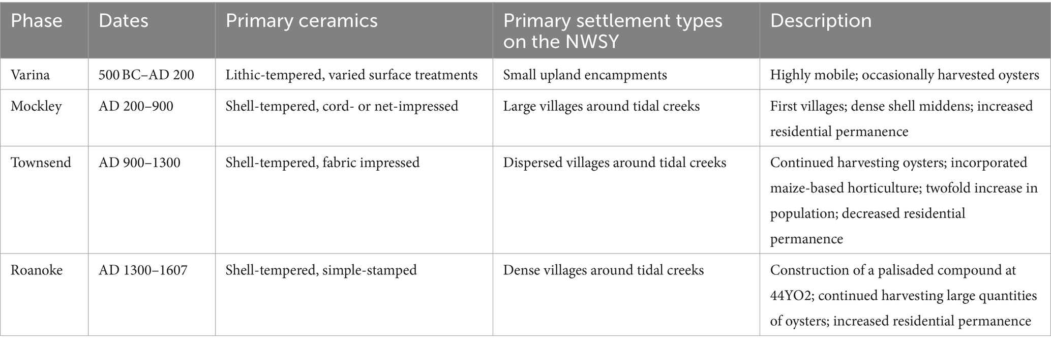
Table 1. Cultural phases in the study area.
The Mockley Phase witnessed the creation of settlements with considerably higher levels of residential stability in conjunction with the first pan-Chesapeake material tradition, shell-tempered Mockley ceramics. Residential stability refers here to the span of time spent at a location during the annual cycle, which may range from less than a single day to an entire year (Gallivan, 2002). The Mockley Phase increase in residential stability predated the arrival of domesticates and of horticulture by centuries, and the social dynamics that followed influenced coastal communities through the colonial era. Mockley Phase villages appeared first in the southern part of the Chesapeake within the Outer Coastal Plain (i.e., the lower portion of the estuary closest to the Chesapeake Bay) in locations accessible to oyster reefs and fishing grounds. Archeologists have long hypothesized that the process of settling down in the Chesapeake began in areas where forager-fishers gathered around settings with rich, diverse, and predictable resources (e.g., Gardner, 1982: Nash, 2020, p. 138). A remaining question concerns how the social relationships that formed around these estuarine resources changed during the Mockley Phase in ways that encouraged communities to form persistent places on the water.
The case study below considers the historical process of settling down in the lower York River area of the Chesapeake’s Outer Coastal Plain (Figure 1). We rely on an archeological survey of the Naval Weapons Station Yorktown (NWSY), a 14,000-acre military facility (Blanton et al., 2005) and an analysis of archeological shell from midden deposits within the base (Jenkins and Gallivan, 2020). The comprehensive survey of a landscape on this scale allows for “non-site” approaches to settlement patterns (Dunnell and Dancey, 1983) that highlight changing mobility practices and the establishment of persistent places along tidal waterways. Rather than relying on site boundaries, a non-site approach draws on shovel test data to consider the distributions and concentrations of materials across a landscape. Represented visually, these data allow for inferences regarding the places people dwelled and the pathways through which they traveled. Forager-fishers in the lower York constructed enduring communities around the lower embayed portions of tidal creeks that flow into the York River, establishing dispersed settlements anchored by large, community-scale shell middens. Analysis of the oyster shells deposited in these middens leads us to hypothesize that settling down in this part of the Chesapeake began as forager-fishers developed new social relationships around the collective management of the oyster fishery. Analyses of oyster shells presented here include comparisons of morphometric measurements (e.g., height, length, presence/absence of attachment scars, and presence/absence of epibionts) and the amount of oyster and other shellfish species across samples excavated from various deposits.
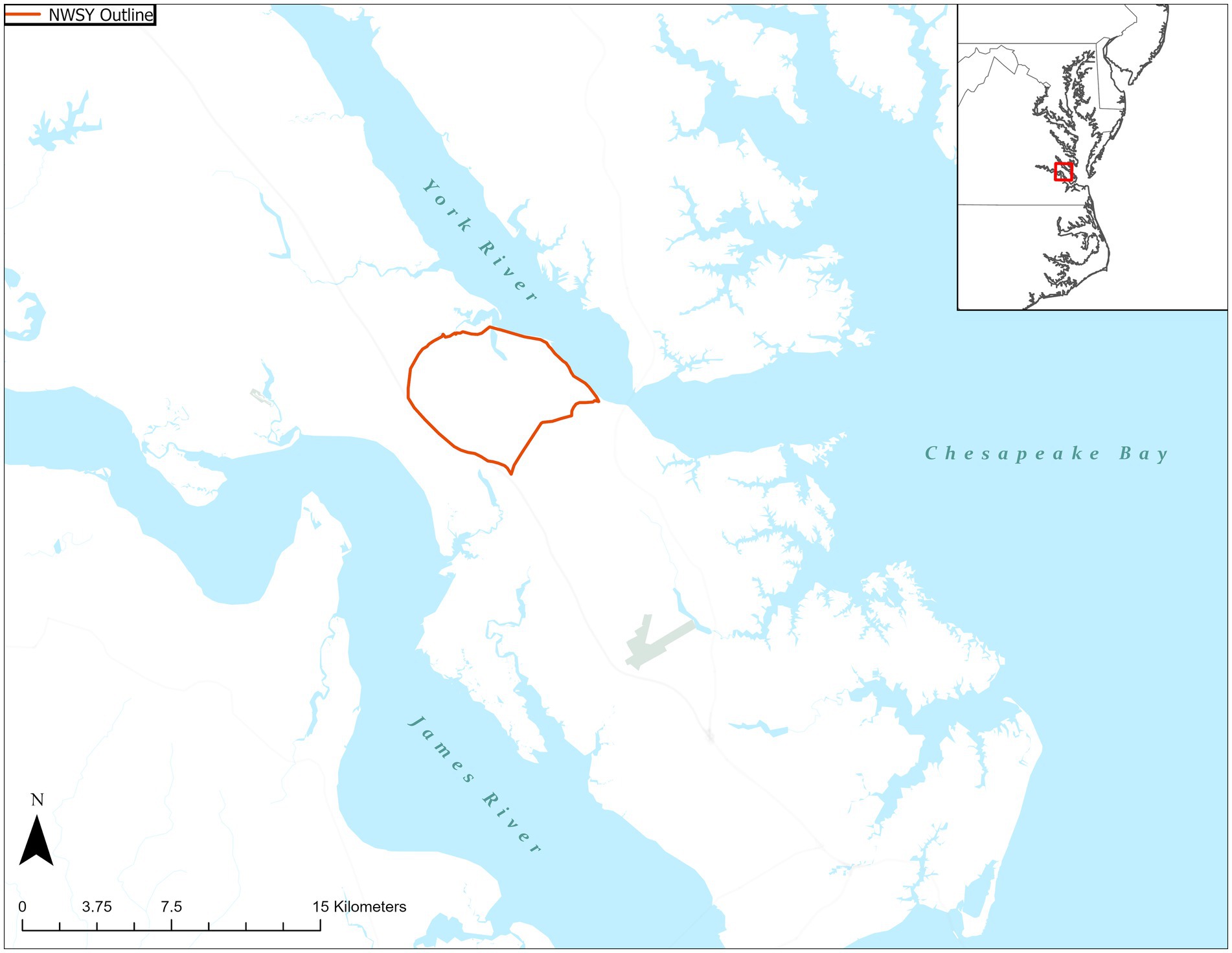
Figure 1. Map showing the location of the Naval Weapons Station Yorktown, Virginia. Map created by Sophie Thacker-Gwaltney.
Preliminary evidence presented here points toward management practices that included selective harvesting of the fishery, a system of marine tenure, enhancement of oyster habitat, and shifts in the ratios of harvested shellfish species. Collectively, these practices represent a form of common pool resource management. Common pool resources are natural or man-made features like fisheries, forests, or irrigation systems shared by a community that require collective management to prevent overuse and depletion (e.g., Lansing et al., 2014; Aiuvalasit, 2019). As detailed in the scholarship of Ostrom (2002, 2019), local communities often establish norms, rules, and institutional frameworks around these resources to foster equity and to block “free riders” from depleting these resources. The archeological and paleoenvironmental records from the NWSY suggest that collective action was aimed at maintaining the productivity of common pool resources, including the oyster fishery.
We see evidence that forager-fishers’ decisions to settle down along the waterways of the lower York were accompanied by a suite of practices tied to resource management. Drawing from historical and ethnographic sources, Ostrom (2019) observed that around the world, common pool resources are often effectively governed by local community-led institutions, independent of political authority or private ownership. Given the opportunity for cooperation and an effective set of rules, environmental degradation was by no means the inevitable result of collective use of the commons. Within the lower York (Jenkins and Gallivan, 2020) and across the wider Chesapeake (Rick et al., 2016; Reeder-Myers et al., 2022) coastal communities harvested the oyster fishery intensively and sustainably on a millennial timescale.
Mockley Phase changes in the lower York River marked a significant social transformation in the ways Native people engaged with estuarine resources, moved through the landscape, interacted with one another, and experienced their world. As detailed below, not everyone in the Coastal Plain made the decision to settle down. Even as some individuals and households chose to reside in larger, more permanent estuarine settlements, others chose to maintain high mobility, small settlements, and a “traditional” socioeconomic orientation toward upland resources (Blanton et al., 2005, p. 252). These generalist hunter-gatherers continued to produce lithic-tempered ceramics for the first four centuries of the Mockley Phase, regularly encountering the forager-fishers living along the water (Blanton and Pullins, 2004; Gallivan, 2016, p. 72). The product of socially complex and historically contingent factors, the Mockley Phase in the Chesapeake represents an important and formative shift toward “settling down.” The following traces the historical process of settling down in the Chesapeake through a consideration of the Coastal Plain during the Mockley Phase, a case study of the Naval Weapons Station Yorktown, and an interpretation of the sociality of management on the lower York River.
Named for its distinctive shell-tempered pottery, the Mockley Phase encompasses the latter half of the Middle Woodland period in coastal areas from the mouth of the Chesapeake to the Delaware Bay (Blanton, 1992; Stewart, 1992; Potter, 1993, pp. 103–114; Gallivan, 2011, pp. 289–294: Nash, 2020). Mockley Phase settlements were marked by shell-tempered pottery, an estuarine subsistence orientation, and dispersed riverine settlements, a suite of practices that remained in place through the early colonial period in the Chesapeake region.
Mockley ware vessels are coil-constructed jars with rounded bottoms tempered with crushed shell, typically oyster (Egloff and Potter, 1982, p. 103) (Figure 2). Prior to the Mockley Phase, ceramics in the Chesapeake included a dizzying array of lithic and sand tempers, surface treatments, and vessel forms with localized distributions, highlighting small-scale, closed interaction networks.
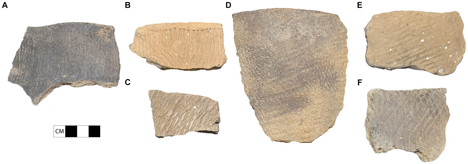
Figure 2. Diagnostic pottery in the research area. (A) Varina pottery (sand-tempered, cord-marked); (B,C) Mockley pottery (shell-tempered; cord-marked); (D) Townsend pottery (shell-tempered; fabric-impressed); (E,F) Roanoke pottery (shell-tempered; simple-stamped).
Studies of shell-tempering indicate that the practice offers functional advantages to ceramic vessels while also demanding more precise control over the firing process, making it challenging to produce (Feathers, 2006; Feathers and Peacock, 2008; Herbert, 2008; Rick and Lowery, 2013). Shell-tempering offers improved resistance to thermal shock and vessel strength over sand-, lithic-, or grog-tempered wares. Successfully producing a shell-tempered pot requires reducing the firing atmosphere and precisely controlling the burn. Lime spalling (i.e., when fragments flake away from the vessel body), may occur when the firing temperatures exceeds a threshold. Additionally, if shell-tempered pottery is not sufficiently fired, it can negatively affect vessel strength.
Even with the advantage of increased vessel strength offered by shell-tempered pottery, some communities in the Chesapeake Coastal Plain continued to make sand- and lithic-tempered pottery for several centuries into the Mockley horizon. Sand- and lithic-tempered ceramics, including Varina ware, continued to appear within small, interior sites through AD 600 (Gallivan, 2016, p. 72). Given this selective adoption and the challenges of producing shell-tempered vessels, the shift to shell-tempering appears to have been as much a social innovation as a practical one. Estuarine-oriented communities’ shell-tempered pottery may have served as a marker of their relational identity within a landscape where at least two social traditions coexisted. The shell-tempered ceramic tradition united coastal dwellers from the mouth of the Chesapeake Bay to the Delaware Bay within a large estuarine “interaction sphere” (Custer, 1990). The process of settling down in the Chesapeake evidently included a shift from small-scale, closed social networks toward open networks of marriage and alliance that eventually stretched across the Middle Atlantic coast. The earliest shell-tempered pottery appeared first alongside oyster reefs in the southern Chesapeake (Rick and Lowery, 2013) representing a “home grown” innovation accompanied by a suite of socioeconomic changes, including new settlement and subsistence patterns, community affiliations, and regional ties (Nash, 2020, p. 127). Mockley pottery incorporated crushed particles of the very shells around which estuarine communities gathered, raising the possibility that the ware was emblematic of the practices and places linking estuarine communities across the coastal Middle Atlantic.
Mockley Phase sites in the Chesapeake highlight an historic process of settling down around rich and predictable estuarine resources (Custer, 1990; Blanton, 1992; Potter, 1993; Dent, 1995; Nash, 2020). The settlement pattern data from this period point to a seasonal round—or perhaps two connected seasonal rounds—scheduled to capitalize on the peak availability of productive staples such as shellfish, anadromous fish, mast, and deer. Communities using Mockley ceramics focused on the estuarine and riverine portions of this landscape. Places of seasonal aggregation containing dense concentrations of Mockley ceramics included locations in the lower, brackish portion of the estuary near oyster reefs and clam beds harvested during the fall and winter months. Other large Mockley Phase sites were located upriver, marking spring and summer gatherings located near anadromous fish runs. Where the settlement round of Mockley forager-fishers aligned with the linear pathways of the Chesapeake estuary, communities producing Varina pots continued to make repeated use of interior encampments with ready access to mast and deer. Circa AD 200–600, hunter-gatherer groups using Varina ceramics continued to circulate between upland encampments in the same mobile settlement pattern used in previous centuries. Where these groups came into contact, the archeological record hints that foods may have been exchanged as a result of the “mutualism” of different hunter-gatherer groups (Blanton and Pullins, 2004).
Along with an increased settlement focus on the Outer Coastal Plain, large Mockley Phase settlements also appeared in some Inner Coastal Plain locations, including areas associated with anadromous fish runs. Anadromous fish live most of their lives in the ocean, returning to freshwater to spawn. In the Chesapeake, striped bass, sturgeon, alewife, and herring migrated in large numbers to the Inner Coastal Plain during the spring. These species provided a rich and predictable resource for those communities with the requisite traditional ecological knowledge and willingness to act collectively to construct weirs in the freshwater shallows of tidal creeks (Holmes, 1907).
Located in the James River’s Inner Coastal Plain, the Maycock’s Point site represents a large Mockley Phase settlement near the mouth of a freshwater creek (Opperman, 1992; Makin, 2018). The site is marked by a dense Mockley Phase midden containing faunal material from a range of terrestrial and riverine species, including eastern elliptio (Elliptio complanata), a freshwater mussel. This site’s substantial size and resource-rich location make it a prime example of settling down in the Inner Coastal Plain alongside freshwater mollusks and anadromous fish runs (Nash, 2020, p. 142). Faunal analysis of Maycock’s Point’s midden deposits suggests a warm weather occupation (Opperman, 1992, p. 90), aligning with the understanding that anadromous fish runs drew residents to the location on a seasonal basis.
Alongside the Mockley ceramics recovered from Maycock’s Point’s midden are similar shell-tempered ceramics decorated with elaborately incised linear designs (Makin, 2018) (Figure 3). The designs on these Abbott zone-decorated ceramics include combinations of horizontal and vertical lines incised into the vessel, sometimes in the form of nested triangles, diamonds or cross-hatching in distinct zones below the rim. Abbott zoned-decorated ceramics occur as a minority ware on Middle Woodland sites from Virginia through Massachusetts in locations of seasonal aggregation where communities fished and harvested shellfish, leaving behind thick midden deposits (Stewart, 1998). In the Chesapeake, similar zone-decorated ceramics have been found at five sites in the James and York River drainages. Abbott zone-decorated vessels were likely used on special occasions when seasonal fish runs gathered large groups for seasonal aggregations during warm weather months. The intricate incised designs on Abbott ceramics appear to represent fish and fishing-related equipment, including nets and weirs (Lattanzi et al., 2015). The designs on these ceramics may have played a role in establishing and reinforcing social identities in the context of feasting events and collective action to build and repair fish traps (Hantman and Gold, 2000).
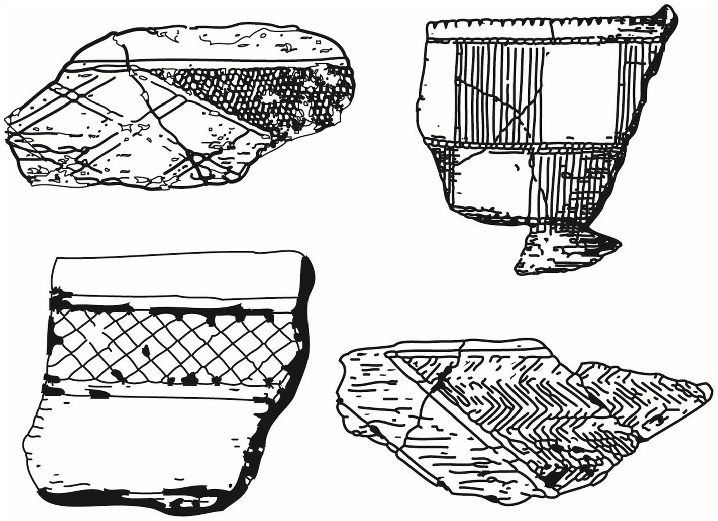
Figure 3. Examples of Abbott zoned incised pottery.
Where Maycock’s Point offers evidence of a Mockley Phase settlement in the Inner Coastal Plain, the pathway toward greater residential permanence in the coastal Chesapeake may be examined through a case study of the Naval Weapons Station Yorktown (NWSY), a military base on the lower York River covering more than 33,000 hectares (see Figure 1). Archeological survey and excavation on the NWSY offers a detailed view of precolonial settlement history in the Outer Coastal Plain (Blanton et al., 2005). The 246 sites identified by the NWSY survey represent almost the entire span of the human past in eastern North America. Sites dating from before 1000 B.C. were oriented toward higher elevations and interior locations, away from the York River and the tidal creeks. During the Varina phase (500 BC–AD 600) the number of sites on the NWSY increased significantly, especially small, single component encampments in interior settings away from the creeks and the York. Circa A.D. 200, at the outset of the Mockley Phase, the number of sites along the York River and lower portions of the tidal creeks again increased with a pivot toward estuarine settings that continued through Contact. The survey data highlight increasing population during the Mockley Phase and the creation of a new settlement form, the creek-based dispersed village community, spread around the lower embayed portions of Indian Field and Felgates creeks.
Starting during the Mockley Phase, a series of spatially separate but socially connected sites overlooking Indian Field creek comprised one of these dispersed creek-side villages (Figure 4). Domestic spaces with associated shell middens dating from AD 200 to the early seventeenth century wrapped around the creek where it empties into the York, and two large shell middens at sites 44YO2 and 44YO687 were located near the creek’s confluence with the York (see Figure 4). Excavation at site 44YO2 has revealed a palisade and ditch feature dating to the subsequent Townsend phase (AD 900–1300), when maize-based horticulture was incorporated into subsistence practices (Figure 5). The colonial era town of Kiskiak starts to come into view on Indian Field Creek during the following Roanoke phase (AD 1300–1607). Bluff-top locations overlooking Indian Field Creek and the York River contain dense midden deposits and domestic structures dating to these centuries, highlighting continued population growth. By the early colonial era, Kiskiak appears on colonist Smith’s (1986) Map of Virginia as a “King’s House,” one of about 30 regional political centers within the Powhatan paramount chiefdom. Across the river from Kiskiak, Smith’s map depicts Cantauncack and Capahosic, two “Ordinary houses” lacking Kiskiak’s political authority.

Figure 4. Map showing the location of sites around Indian Field Creek and Felgates Creek on the Naval Weapons Station Yorktown. Map created by Sophie Thacker-Gwaltney.
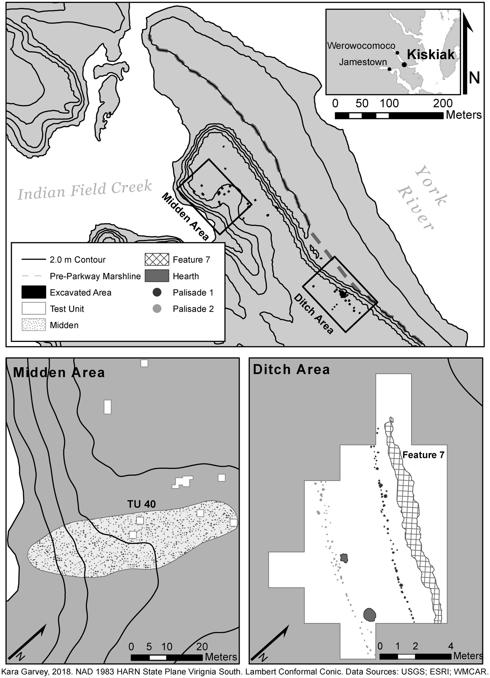
Figure 5. Map showing excavated areas and features at site 44YO2 on Indian Field Creek on the Naval Weapons Station Yorktown.
Reevaluation of the comprehensive shovel test survey of the Naval Weapons Station (Blanton et al., 2005) has allowed us to take a non-site approach to interpreting people’s movement throughout the lower York River landscape. The archeological sites identified within the area imply discreet and spatially bounded areas of human activity (see Figure 4). While this visualization of cultural resources is quite valuable for modern land management, bounded polygons do not accurately reflect past human movement through and engagement with the landscape (Dunnell, 1992). By considering the results of shovel testing without the imposition of site boundaries, we can consider landscape-scale distributions of artifacts and ecofacts that provide insights into movement, mobility, and residential stability (Foley, 1981). This approach allows us to think of past people and their worlds as in motion, and to consider how past practices and social relationships created the archeological record in relation to the landscape.
Using a non-site approach, our research team mapped the distribution of temporally diagnostic pottery and oyster shell density within the NWSY (Figure 6). Focusing on Indian Field Creek and Felgates Creek, several patterns emerge:
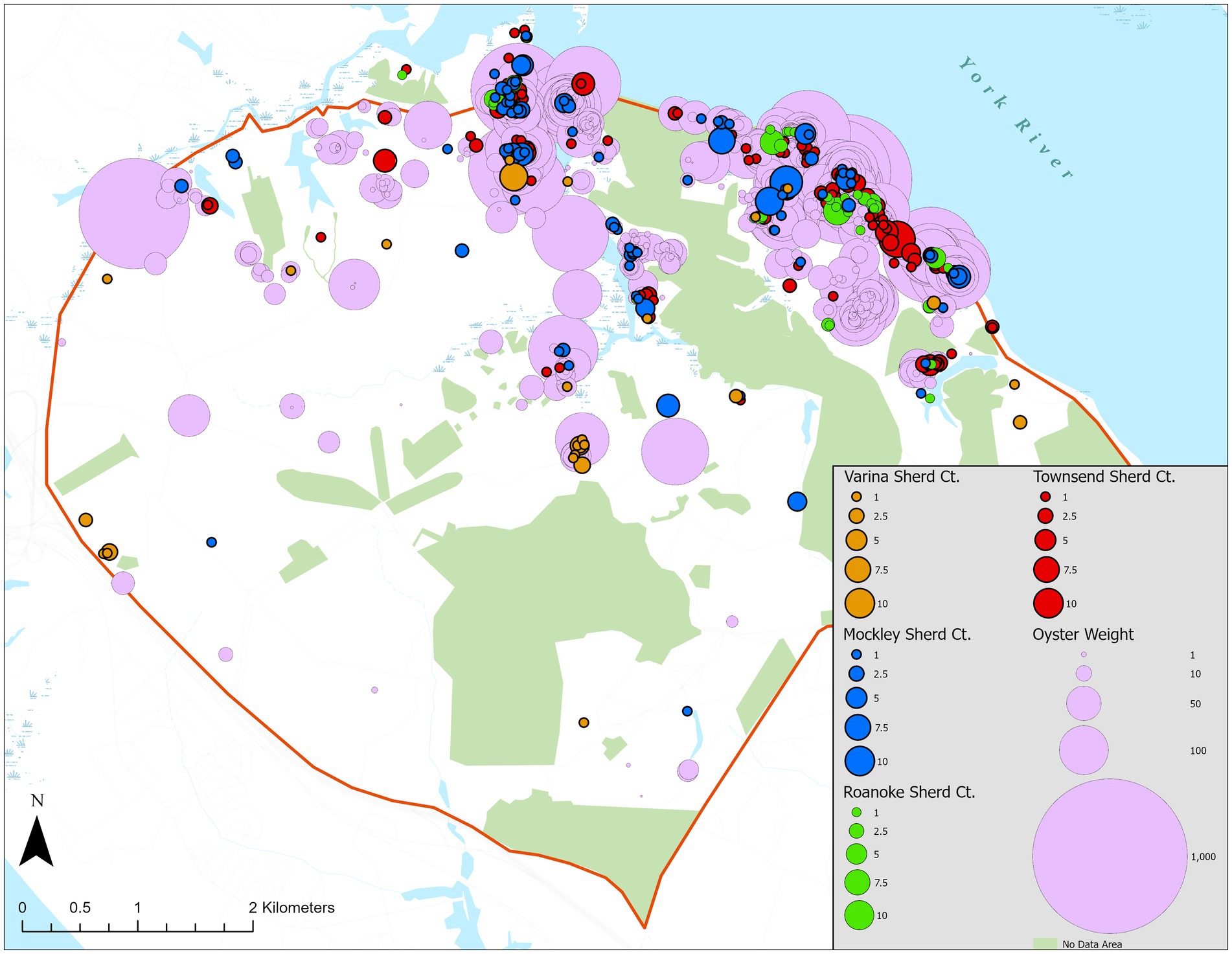
Figure 6. Map showing the distribution of diagnostic pottery and oyster (measured in grams) encountered during shovel testing on the Naval Weapons Station Yorktown. Map created by Sophie Thacker-Gwaltney.
1. There is a significant increase in the number of diagnostic sherds between the Varina and Mockley Phases and again between the Mockley and Townsend phases.
2. Distributions of diagnostic pottery overlap at many locations.
3. Mockley pottery’s distribution includes large concentrations of sherds spread out along the creek and riverbanks.
4. Townsend pottery is ubiquitous, but less concentrated than Mockley pottery, covering a larger geographic extent.
5. The geographic scope of Roanoke pottery becomes restricted once again, with dense concentrations near the mouths of creeks.
While these patterns likely index increased population through time, they also shed light on the creation of persistent places and the movement of people within the landscape. Specifically, these patterns offer evidence of high levels of mobility associated with hunter gatherers using Varina ceramics, place-making and settling down into dispersed creek-side villages during the Mockley Phase, and a shift toward decreased residential permanence in the following Townsend phase. In the final Roanoke phase, the limited distribution of sherds across the landscape almost mirrors the settlement patterns of the Mockley Phase and coincides with the creation of a palisaded compound on the east side of Indian Field Creek (see Figure 5). At this time, it appears that Kiskiak’s residents once again increased their residential stability while restricting much of their movement to the bluffs overlooking the York River and tidal creeks.
The overlap in diagnostic ceramics on the landscape offers evidence of some continuity in landscape usage after AD 200. However, one of the drawbacks of shovel test data is the lack of tight temporal control. While diagnostic artifacts help us interpret change over time, there is also a considerable overlap in the date ranges of diagnostic types in the region (see Table 1). Therefore, the presence of both Varina and Mockley pottery in one place could indicate the location of a persistent place that was occupied or visited across centuries, a place of social interaction between two contemporaneous communities between AD 200 and 600, or both. Further excavation and research at these sites will help to parse out this ambiguity. There are also several places across the NWSY landscape with both Mockley and Townsend pottery. However, whereas most places with Mockley pottery also have Townsend sherds, not all places with Townsend pottery also have Mockley sherds. We suspect that this represents a transformation of settlement practices, where people moved more often during the Townsend phase as agricultural fields were cleared and others were left fallow. In fact, when English colonists arrived in the region in the seventeenth century, they observed that Powhatan communities in the area routinely moved their settlements as they cleared new agricultural fields, with towns moving “amoebalike” up and down waterways (Rountree et al., 2007, p. 33).
Shovel test data show that oyster shell is distributed across the landscape in variable densities. The highest oyster concentrations on land are found on the east sides of creek mouths alongside dense concentrations of Mockley and Townsend sherds (see Figure 6). Excavation at creek-side villages on the lower York River have revealed three types of oyster-rich deposits: the King’s House Midden at 44YO2, community middens on sloping landscapes leading to the creeks, and ephemeral household middens in upland areas (Jenkins et al., 2023). Oyster shells are also found within short-term or special use deposits such as oyster roasting pits or the oyster-filled ditch feature associated with the thirteenth-century palisaded compound at 44YO2. The largest identified shell midden on the NWSY is located on the east side Indian Field Creek and measures 50 by 25 meters with a depth of over two meters (see Figure 5). We have labeled this deposit as the King’s House Midden due to its proximity to Kiskiak’s palisaded compound. Other large concentrations of oyster shell along the edges of creeks appear to represent community-scale middens created by routine and extensive oyster harvesting and consumption by settled, creek-side villagers. The lighter distribution of oyster shell identified by shovel test survey in blufftop areas appears to represent household middens located alongside domestic spaces.
Based on the excavation of the King’s House Midden at 44YO2, we have estimated that the number of oysters harvested between AD 200 and 1600 by forager-fishers settled at this location likely exceeded 70,000,000 (Jenkins and Gallivan, 2020, p. 19). When this number is extended to include the estimate of oysters deposited in other middens (i.e., household middens and community middens) and shell-rich deposits around Indian Field Creek, the number of oysters harvested by this single settled community likely exceeded 200,000,000. If we consider this estimate alongside historical ethnography indicating that oysters were only harvested during half the year, then our evidence suggests that the community settled around Indian Field Creek likely collected 5,000 oysters per week, primarily from the waters surrounding the settlement. With an estimated 150 residents living in distributed settlements around Indian Field Creek circa 1607, this amounts to a consumption rate of about five oysters per person per day, which is not only reasonable, but likely at the low end of the actual harvesting and consumption rates given historical accounts of regular oyster consumption punctuated by communal feasts centered on large quantities of shellfish.
Feinman and Neitzel’s (2023) model draws attention to social realignments linked to the stresses and cognitive limits of larger, more permanent communities and the types of resources available to those electing to settle down. In the Chesapeake during the Mockley Phase, community and intercommunity relationships were renegotiated as people settled into creek-side villages, and the distribution of oysters and fish runs were integral to the resulting social arrangements. Following Thompson (2018, p. 27), we suspect that Mockley Phase settlement shifts meant that people residing along waterways throughout the Chesapeake encountered one other on a more regular basis as they moved throughout the new waterscape, exploited estuarine species, and gathered at places of social and cosmological importance. A series of creek-side villages appeared during the Mockley Phase in close proximity on the lower York River, and canoes facilitated fast travel between Indian Field and Felgates creeks and across the river to Cantauncack and Capahosic, the “Ordinary Houses” within Kiskiak’s orbit. With the significantly larger populations of the Mockley period and the connectivity afforded by the Chesapeake estuary, we suspect that a new set of rules or principles were established governing access to and management of estuarine resources within these waterways. As detailed below, patterns and practices related to collective management on the lower York River may be considered in terms of selective harvesting of resource patches, a system of marine tenure, deliberate enhancement of resource habitat, and shifts in the ratios of targeted shellfish species.
Archeological evaluations of the sites that comprised the dispersed creek-side village at NWSY included excavations on the east side of Indian Field Creek (Blanton et al., 2005, pp. 27–70; Gallivan, 2016, pp. 68–103). This portion of Kiskiak, designated site 44YO2, was bounded by a ditch and palisade feature constructed in the thirteenth century AD along the bluff above the York River (see Figure 5). Located 400 meters west of this feature along the water’s edge, a stratified shell midden along Indian Field Creek extends approximately 50 by 25 meters in plan and two meters in depth. Our preliminary assessment of oyster management at Kiskiak centered on a comparison of the shells deposited in this large midden and in the ditch feature (Jenkins and Gallivan, 2020). The shells in the midden and in the ditch represented different sets of harvesting and consumption practices, with the ditch oysters likely associated with feasting practices distinct from the regular consumption of oysters deposited in the midden. Our analysis indicated that Kiskiak’s residents harvested primarily nearshore oysters, even though they were fully capable of taking deepwater oysters and did so occasionally to provision feasts. These selective harvesting practices likely contributed to the sustainability of the oyster fishery. Nearshore oysters represent net sink populations (i.e., reefs that cannot sustain themselves without individuals migrating in from source populations, such as the parent reefs located in offshore, deepwater settings).
Our study of oysters deposited in the King’s House Midden demonstrates that the intensive level of harvesting described above was sustainable, with mean oyster height (i.e., size) decreasing marginally during the initial zenith of oyster harvesting (circa A.D. 600), and then rebounding in the following centuries, even as people continued to extensively harvest nearshore reefs (Jenkins and Gallivan, 2020, p. 15). Given the evidence of substantial population increases in the area and continued residence in creek-side settlements, this pattern suggests that forager-fishers likely engaged in management of this valuable resource.
On the NWSY, Mockley Phase creek-side villages were arranged along the bluffs overlooking creeks tributary to the York River. These distributed settlements formed a U-shape oriented around a central body of water. Large, dense shell middens accumulated on the slopes at creek mouths. Similar to plazas in other North American Indigenous settlements, creeks served as central places of collective action within communities, including shellfish gathering and fishing using weirs. We hypothesize that a system of marine tenure was set in place at the start of the Mockley Phase. Within this system, creek-side villages maintained control over fish weirs and shellfish within the creek along which they settled, while offshore reefs in the York River channel were regulated as a shared resource governed by rules that limited harvesting to special occasions.
In this way, we suspect that offshore reefs represented public goods in contrast to the intertidal reefs controlled by creek-side communities. A public good refers to a resource that is non-excludable and non-rivalrous, meaning that it is impractical to exclude others from accessing it and the consumption of the resource by one individual does not reduce its availability to others. As well as solving a collective action problem around access to public goods, this arrangement likely functioned as an effective management strategy whereby nearshore intertidal oyster populations were regularly harvested, and offshore populations were mostly conserved and left to spawn.
Evidence for a system of marine tenure and management is supported by patterning within a subsistence column from site 44YO2’s midden, which contains stratified deposits spanning the Late Archaic period through colonial contact (Jenkins and Gallivan, 2020). Recovered material included vertebrate faunal remains (bird, deer, drum, and small fish vertebra), lithics, and oyster and clam shells. The recovery of the remains of small fish from the midden points toward the use of fish weirs during the Mockley Phase. As described by Jamestown’s colonists (e.g., Strachey, 1953, p. 68), fish weirs in the Chesapeake consisted of complex enclosures made from woven reeds:
…their weares in which they take their fish, which are certaine inclosures made of reedes, and framed in the fashion of a laborinth or maze sett a fathome deepe in the water, with divers chambers or bedds, out of which the entangled fish cannot returne or gett out, being once in. Well maye a great one, by chaunce, breake the reedes and so escape, otherwise he remaines a pray to the fishermen the next lowe water, which they fish with a nett at the end of a pole.
The construction, maintenance, and monitoring of fish weirs required collaboration and cooperation among villagers residing nearby (Thompson, 2018, pp. 25–26). Moreover, if controlled by individual creek-side villages, the use of weirs may have afforded fishing rights associated with specific communities (Reitz, 2014; Thompson, 2018, p. 26).
Our analysis of oyster shells excavated from the subsistence column at 44YO2 presented in Jenkins and Gallivan (2020) indicates that they are, on average, relatively small (less than 60 millimeters in height), 2–3 years old, and most were harvested from intertidal reefs located nearby, along the water’s edge. During the Mockley Phase, about 20 percent of the oysters show evidence that they were harvested from offshore reefs, indicating limited access to these reefs, possibly as a result of agreed-upon principles governing access to these resources as public goods. Conversely, oysters from a feasting deposit within Kiskiak’s palisaded compound are significantly larger than those in the midden and most show evidence that they were harvested from offshore, subtidal reefs (Jenkins and Gallivan, 2020, p. 16).
To better understand the archeological signature of marine tenure, we developed a model of the morphology and bioindicators of oyster shells local to the lower York area. As part of this effort, we assembled a team of interdisciplinary researchers consisting of archeologists, geologists, and marine scientists to sample and measure modern oysters from different resource niches that spanned tidal and salinity zones (i.e., nearshore versus offshore, shallow water versus deep water) of the lower York River. Preliminary results indicate that oyster morphology and bioindicators vary in statistically significant ways by tidal zone and across creeks in accordance with salinity, water depth, stream flow rates, and available substrate (Jenkins and Gallivan, 2022). These results confirm our hypotheses as well as the work of Kent (1988) and Lawrence (1988), demonstrating that it is possible to infer which oyster resource patch was harvested by past people through analyses of oyster shell morphometrics and bioindicators (Figure 7).
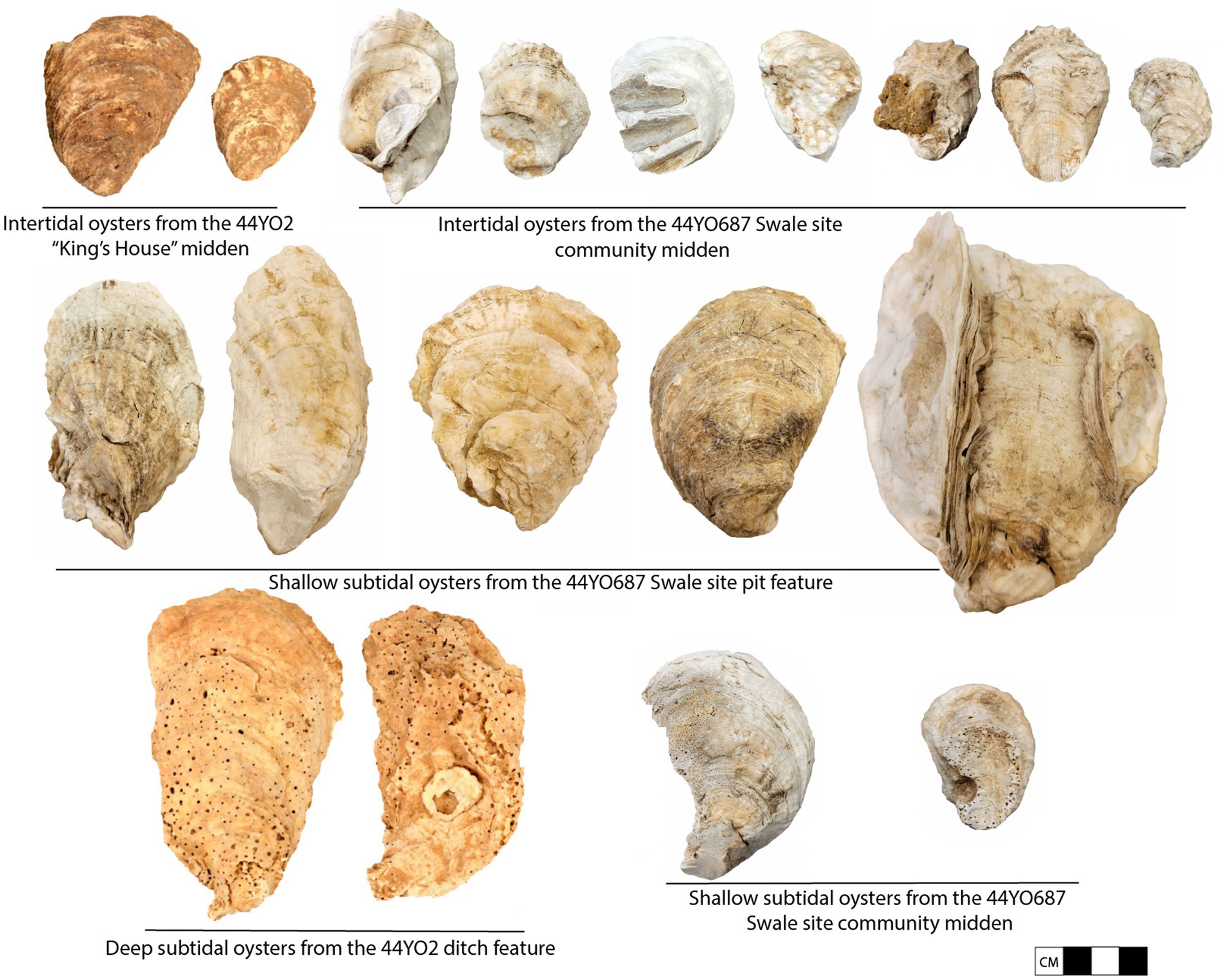
Figure 7. Examples of oysters excavated from sites on the Naval Weapons Station Yorktown and their inferred resource patch.
Alongside evidence of marine tenure and selective harvesting, our research suggests that past people enriched the local oyster habitat around Indian Field Creek by mobilizing fossilized scallop shells (Chesapecten jeffersonius) as substrate for nearshore oyster spat attachment (Jenkins and Gallivan, 2020, p. 14). During the Mockley Phase, nearly 50 percent of oysters deposited in the midden at 44YO2 have attachment scars in the form of fossilized scallop shells. Importantly, fossilized scallop shells are only found in eroding outcrops of the Yorktown Formation geological strata and there is no natural Yorktown Formation outcrop proximate to 44YO2. Moreover, none of the modern oysters harvested from the intertidal or shallow subtidal zones of Indian Field Creek during the summer of 2022 have fossilized scallop shell attachment scars, whereas modern oysters from the intertidal zones of the three creeks proximate to Yorktown Formation outcrops were marked by such scars. Fossilized scallop shells are heavier than oyster shells and can better withstand the tidal environment of Indian Field Creek, acting as an effective anchor for juvenile oysters to attach to as they mature prior to harvesting. Fragments of fossilized scallop shells likely ended up in midden deposits as a biproduct of oyster harvesting in the intertidal zone. Evidence of substrate creation using these fossils is further supported by the increased ratio of fossilized shell to oyster shell during the Mockley Phase documented in survey data reported by Blanton et al. (2005, p. 235) (Figure 8). Our data, as well as those compiled by Blanton and colleagues, point toward the mobilization of fossilized shell as substrate even prior to the Mockley Phase, as people settled down along Indian Field Creek and harvested oysters, demonstrating a deep-seated tradition and long-term ecological knowledge associated with oyster harvesting and propagation in this location.
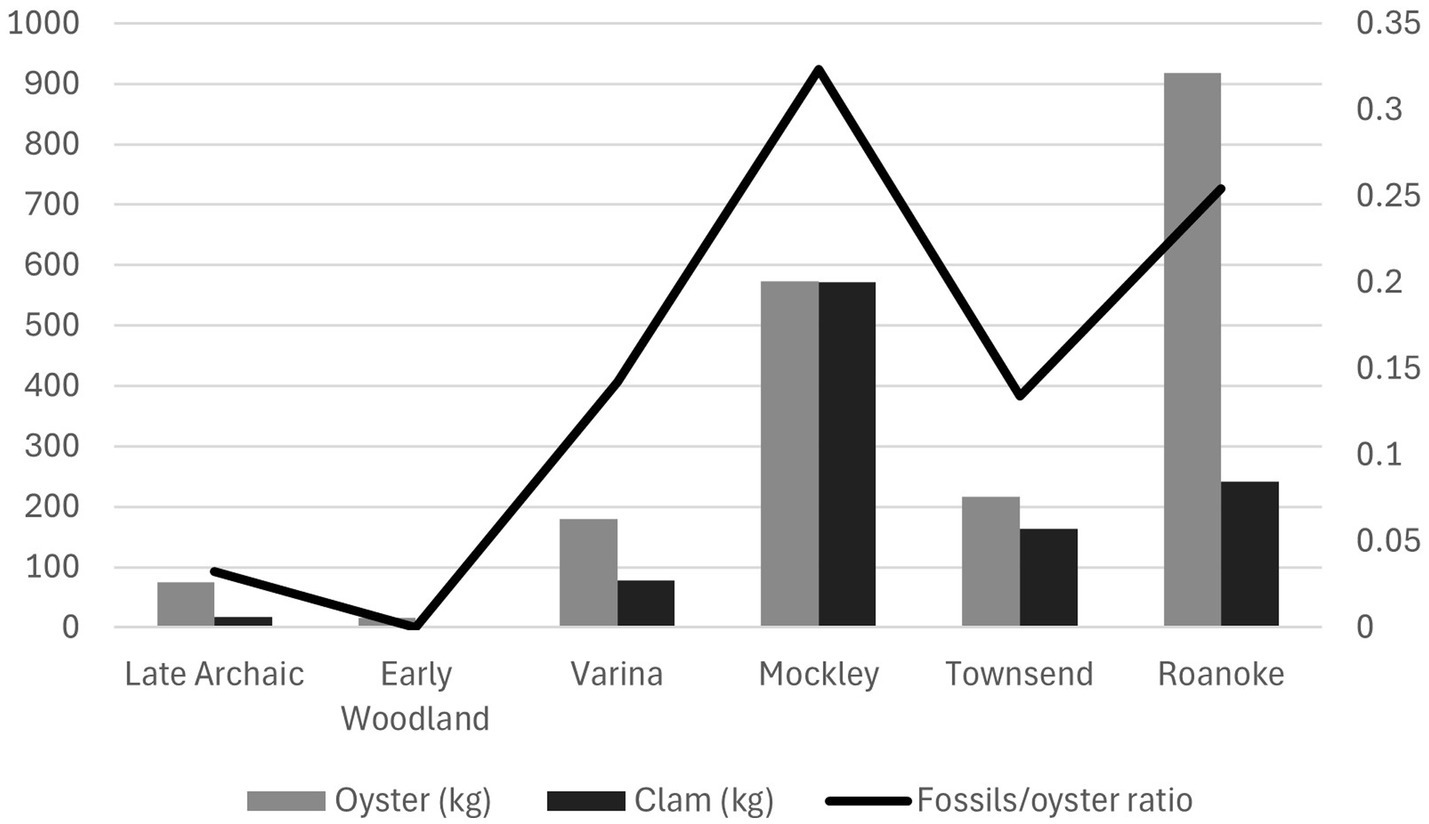
Figure 8. The ratio of fossilized scallop shell to oyster and changes in oyster and clam weight during different cultural phases on the Naval Weapons Station Yorktown (data from Blanton et al., 2005, p. 35).
A final line of evidence suggesting management of the oyster fishery during the Mockley Phase can be seen in the ratio of shellfish species found in midden deposits. Shell weight data compiled by Blanton et al. (2005, p. 235) documents a three-fold increase in oyster shell deposited in creek side middens between the Varina and Mockley Phases alongside a roughly equal amount of clam (Mercenaria mercenaria) shells (see Figure 8). This is the first and only time in the history of shellfishing on the NWSY where the weight of clam shells is roughly equivalent to the weight of oyster shells recovered from creek-side middens. Clams were harvested from Indian Field Creek both before and after the Mockley Phase in lower quantities, signaling their availability throughout Kiskiak’s occupational history. Indian Field Creek is located in the high-density zone for clams on the York River, with a salinity of approximately 15–18 parts per thousand (ppt) (Roegner and Mann, 1990, p. 5). The Chesapeake Bay estuary was essentially complete by about 3,000 years ago (Dent, 1995, p. 84), with only modest shifts in salinity regimes since then.
The significant increase in clam harvesting during the Mockley Phase may relate to environmental changes that triggered alterations in clam habitat, however it seems more likely that this pattern was the product of changing harvesting practices. Whether the result of intentional management strategy or not, the Mockley Phase deposits document increasing comparable relative abundance in weight (kg) in targeted shellfish, even while the number of identified shellfish taxa remained low. A shift away from a heavy reliance primarily on oysters likely allowed shellfish resources to be harvested at a high rate while distributing the predation pressure between two species, reducing the chances of overharvesting and population decline of either one.
While we still have much to learn about the history of settling down in the Chesapeake region, we see evidence that collective action by creek-side villagers during the Mockley Phase played a vital role in this historical process. Evidence points toward selective harvesting of resource patches, a system of marine tenure, habitat enhancement, and shifting shellfish species ratios. While some of these strategies may have been employed by earlier people, our evidence suggests that formal institutions of common pool resource management were instantiated during the Mockley Phase. Between AD 200 and 900, community size and residential stability increased, and creek-side villagers focused their resource procurement on estuarine species, including fish and shellfish. Management of the fisheries was a social process that required collective decision making, cooperation, and collaboration. Resource management and new social arrangements afforded by settling down increased interaction within and among communities as they moved throughout the land- and waterscapes of the lower York River.
Archer (1998, p. 119), one of the Jamestown Colony’s original settlers, wrote of the Chesapeake region as a land of braided streams that abounded with fish and forests:
Here be many small rivers of brooks which unlade themselves into this main river at several mouths, which veins divide the savage kingdoms in many places, and yield pleasant seats in all the country by moistening the fruitful mold [i.e. land]. The main river abounds with sturgeon very large and excellent good, having also at the mouth of every brook and in every creek both store and exceeding good fish of divers kinds; and in the large sounds near the sea are multitudes of fish, banks of oysters, and many great crabs rather better in taste than ours…. It is generally replenish’d with wood of all kinds and the fairest, yea, and best that ever any of us (traveler or workman) ever saw.
Writing in 1607, Archer was struck by the Chesapeake’s resource richness, as well as the ways estuarine waterways defined Native political territories. These densely populated “kingdoms” were built upon estuarine towns settled by earlier generations around oyster beds and fish weirs.
A deep history of Native settlement in the Coastal Plain suggests that fishery management powered by traditional ecological knowledge played an instrumental role in the historical process of settling down in the Chesapeake. Anchored by shell middens and fish weirs, Mockley settlements represent the first large and enduring communities in the region. Evidence from Mockley shell middens suggests that collective action aimed at conserving and enhancing the productivity of local fisheries played a role in the establishment of creek-side villages occupied for centuries.
As in other places, settling down in the Chesapeake was not tied to the adoption of domesticated plants, as maize-based horticulture arrived centuries later in the Chesapeake (circa AD 1100). Nor did settling down in the Chesapeake bring an end to individual or household mobility. Mockley Phase communities appear to have embraced a seasonal pattern of movement up and down the region’s rivers, gathering around shellfish beds and anadromous fish runs at alternating times of year. Riverine travel allowed residents of these communities to cover considerable distances, and canoe-borne mobility likely played a role in the spread of the Mockley tradition from its origins in the southern Chesapeake to the north side of the Delaware Bay. An expanding social network resulted in the Mockley interaction sphere, bringing shell-tempered ceramics and estuarine-oriented lifeways to communities across an expansive region. This process was not unidirectional or irreversible, as indicated by the dispersal of small farmsteads with the arrival of maize during the subsequent Townsend phase. Residential mobility appears to have increased during this period, as residential settlements dispersed across the landscape and shifted locations more frequently.
Archeological evidence from the lower York River suggests that settling down in the Chesapeake resulted from a set of decisions to focus on estuarine resources and a reorganization of social relationships. Not only did shell-tempered ceramics index a new settlement orientation, but the ware also traced an opening up of social networks and a broadening of regional ties. Even with the expanding scope of coastal settlements incorporated within the Mockley interaction sphere, some groups opted out of the decision to affiliate with creek-side villages. In the lower York River, the coexistence of distinct material traditions and divergent settlement rounds from AD 200 to AD 600 suggests that not everyone in the area chose to pivot toward waterfront living, even when they could do so. These contrasting patterns bring into sharp relief the importance of decision-making and agency in the history of settling down in the Chesapeake. During the critical Middle Woodland centuries when communities first settled down in the Chesapeake, the decision to affiliate with creek-side villages was evidently one that some individuals and households made willingly, whereas highly mobile foragers continued to focus their settlement and subsistence practices on upland resources for generations into the Mockley Phase.
Our ability to infer from the archeological record the collective action, harvesting guidelines, and institutional arrangements of Mockley Phase forager-fishers is admittedly limited, though the evidence points toward a suite of practices that sustained the oyster fishery across centuries of intensive harvesting. Selective harvesting of the oyster fishery left the deep-water reefs largely intact, even as communities exploited this resource patch occasionally. Forager-fisher communities appear to have adopted a system of marine tenure structured around the lower, embayed portions of tidal creeks, starting with the Mockley Phase. Communities in the lower York also enhanced oyster habitat by adding substrate to the waterways in the form of fossilized shell. A shift in the ratios of harvested shellfish species accompanied the Mockley Phase, highlighting practices that alleviated harvesting pressure on these resources. The archeological record of these practices indicates that they became more prominent during the Mockley Phase, during the centuries after groups in the Outer Coastal Plain elected to settle down. Our future research will include evaluating and incorporating further lines of evidence, including isotopic sclerochronology to address seasonality and refining the chronology through additional radiocarbon dates and Bayesian modeling of settlement histories.
Collective action and successful stewardship of the oyster fishery in the lower York River required locally organized techniques, decision-making structures, and rule frameworks that defined user communities, organized extraction, and maintained yields and harvests (Robbins, 2020, p. 53). The archeological evidence highlights the management practices of Mockley Phase forager-fishers, in part due to the durability of oyster shells and their accumulation in stratified midden contexts. Once they elected to settle down, Native people in the Chesapeake did more than simply manage and consume oysters. Understanding the broader scope of collective action in the Chesapeake and its relationship to the establishment of persistent places will require expanding our gaze to include other domains and data sets. As colonist Gabriel Archer’s quotation above suggests, the estuary supported a rich and diverse range of fisheries beyond oysters as well as highly productive forests. Rather than a pristine wilderness with a sparse population and minimal Native impact, we see evidence of management that produced the highly productive estuarine waterscape and landscape described at contact.
The raw data supporting the conclusions of this article will be made available by the authors, without undue reservation.
JJ: Conceptualization, Writing – original draft, Writing – review & editing. MG: Conceptualization, Writing – original draft, Writing – review & editing.
The author(s) declare financial support was received for the research, authorship, and/or publication of this article. Funding for open-access publication of this research was provided by Flagler College.
The authors declare that the research was conducted in the absence of any commercial or financial relationships that could be construed as a potential conflict of interest.
All claims expressed in this article are solely those of the authors and do not necessarily represent those of their affiliated organizations, or those of the publisher, the editors and the reviewers. Any product that may be evaluated in this article, or claim that may be made by its manufacturer, is not guaranteed or endorsed by the publisher.
Aiuvalasit, M. J. (2019). “Identifying common Pool resources in the archaeological record: a case study of water commons from the north American southwest” in Global perspectives on long term community resource management. eds. L. R. Lozny and T. H. McGovern (Cham: Springer), 281–306.
Andrus, C. F., and Thompson, V. D. (2012). Determining the habitat of mollusk collection at the Sapelo Island Shell ring complex, Georgia, USA using oxygen isotope Sclerochronology. J. Archaeol. Sci. 39, 215–228. doi: 10.1016/j.jas.2011.08.002
Archer, G. (1998). “The description of the Now-Discovered River and country of Virginia” in Jamestown narratives: Eyewitness accounts of the Virginia colony. ed. E. W. Haile (Champlain, Virginia: Round House), 118–121.
Blanton, D. B. (1992). “Observations on the middle woodland period of Virginia: a middle Atlantic region perspective” in Middle and late woodland archaeology in Virginia: A synthesis. eds. T. R. Reinhart and M. E. N. Hodges (Richmond: Dietz Press), 65–96.
Blanton, D. B., and Pullins, S. C. (2004) Middle woodland settlement and environment in the chisel run/Powhatan Creek drainage: Archaeological data recovery at sites 44JC127 and 44JC850. William and Mary Center for Archaeological Research, Williamsburg, Virginia.
Blanton, D. B., Underwood, J. R., Birkett, C., and Moore, W. H. (2005) Archaeological evaluation of eight prehistoric-native American sites at naval Weapons Station Yorktown. William & Mary Center for Archaeological Research, Williamsburg, VA.
Custer, J. F. (1989) Prehistoric cultures of the Delmarva Peninsula: An archaeological study. University of Delaware Press, Newark.
Custer, J. F. (1990). The woodland I-woodland II transition in the Delmarva Peninsula and Southeast Pennsylvania. North Am. Archaeol. 11, 273–287. doi: 10.2190/HKN7-TPHE-UWXX-7MDA
Dent, R. J. (1995). “Interdisciplinary contributions to archaeology” in Chesapeake prehistory: Old traditions, new directions (New York: Plenum Press)
Dunnell, R. C. (1992). The Notion Site In Space, Time, and Archaeological Landscapes, edited by Jaqueline Rossingnol and LuAnn Wandsnider, pp. 21–41. Springer, Boston.
Dunnell, R. C., and Dancey, W. S. (1983). “The Siteless survey: a regional scale data collection strategy” in Advances in archaeological method and theory (Berkley, California: Elsevier), 267–287.
Egloff, K. T., and Potter, S. R. (1982). Indian ceramics from coastal plain Virginia. Archaeol. East. N. Am. 10, 95–117.
Feathers, J. K. (2006). Explaining Shell-tempered Pottery in Prehistoric Eastern North America. J. Archaeol. Method Theory 13, 89–133. doi: 10.1007/s10816-006-9003-3
Feathers, J. K., and Peacock, E. (2008). Origins and spread of Shell-tempered ceramics in the eastern woodlands: conceptual and methodological frameworks for analysis. Southeast. Archaeol. 27, 286–293.
Feinman, G. M., and Neitzel, J. E. (2023). The social dynamics of settling down. J. Anthropol. Archaeol. 69:101468. doi: 10.1016/j.jaa.2022.101468
Foley, R. (1981). A Model of Regional Archaeological Structure. Proceedings of the Prehistoric Society. 47, 1–47.
Gallivan, M. D. (2002). Measuring sedentariness and settlement population: accumulations research in the middle Atlantic region. Am. Antiq. 67, 535–557. doi: 10.2307/1593825
Gallivan, M. D. (2011). The archaeology of native societies in the Chesapeake: new investigations and interpretations. J. Archaeol. Res. 19, 281–325. doi: 10.1007/s10814-010-9048-4
Gallivan, M. D. (2016) The Powhatan landscape: An archaeological history of the Algonquian Chesapeake. University Press of Florida, Gainesville.
Gardner, W. M. (1982). “Early and middle woodland in the middle Atlantic: an overview” in Practicing environmental archaeology: Methods and interpretations. ed. R. Moeller (American Indian Archaeological Institute: Washington, CT), 53–86.
Garland, C. J., and Thompson, V. D. (2023). Collective action and shellfish harvesting practices among late archaic villagers of the South Atlantic bight. J. Anthropol. Archaeol. 69:101483. doi: 10.1016/j.jaa.2022.101483
Hantman, J. L., and Gold, D. (2000). “The woodland in the middle Atlantic: ranking and dynamic political stability” in The woodland southeast. eds. D. G. Anderson and J. M. Robert C (Tuscaloosa: University of Alabama Press)
Herbert, J. M. (2008). The history and practice of Shell tempering in the middle Atlantic: a useful balance. Southeast. Archaeol. 27, 265–285.
Holmes, W. H. (1907). Aboriginal Shell-heaps of the middle Atlantic Tidewater region. Am. Anthropol. 9, 113–128. doi: 10.1525/aa.1907.9.1.02a00080
Jenkins, J. A., and Gallivan, M. D. (2020). Shell on earth: oyster harvesting, consumption, and deposition practices in the Powhatan Chesapeake. J. Island Coast. Archaeol. 15, 384–406. doi: 10.1080/15564894.2019.1643430
Jenkins, J. A., and Gallivan, M. D. (2022). An interdisciplinary study of woodland and protohistoric oyster harvesting in the lower Chesapeake estuary. Current 9, 4–5.
Jenkins, J. A., Gallivan, M. D., and Han, E. (2023). Roast ‘em, shuck ‘em, stick ‘em in a Stew: oyster harvesting and processing practices at a woodland and Protohistoric Village site (44YO687) in the Chesapeake. J. Middle Atlantic Archaeol. 39, 103–120.
Kent, B. (1988) Making dead oysters talk: Techniques for analyzing oysters from archaeological sites. Maryland Historic Trust, Annapolis.
Lansing, J. S., Cheong, S. A., Chew, L. Y., Cox, M. P., Ho, M.-H. R., and Arthawiguna, W. A. (2014). Regime shifts in balinese subaks. Curr. Anthropol. 55, 232–239. doi: 10.1086/675429
Lattanzi, G., Michael Stewart, R., and Pevarnik, G. (2015) It fell from the sky: style, messaging, and information exchange in middle woodland Abbott zoned ceramics. In: Conference paper, middle Atlantic archaeological conference, Ocean City, MD.
Lawrence, D. R. (1988). Oysters as Geoarchaeologic objects. Geoarchaeology 3, 267–274. doi: 10.1002/gea.3340030403
Makin, D. (2018) Zone-decorated pots at the hatch site (44PG51): A late woodland manifestation of an ancient tradition. MA thesis Department of Anthropology, William & Mary, Williamsburg.
Nash, C. (2020). “Middle woodland research in Virginia: a review of Post-1990 studies” in The archaeology of Virginia’s first peoples. eds. E. A. Moore and B. K. Means (Richmond: Archeological Society of Virginia), 123–160.
Opperman, A. F. (1992) Middle woodland subsistence at Maycock’s point (44PG40), Prince George County, Virginia. MA thesis Department of Anthropology, University of Tennessee, Knoxville.
Ostrom, E. (2019) Governing the commons: The evolution of institutions for collective action. Canto Classics, Cambridge University Press: Cambridge.
Potter, S. R. (1993) Commoners, tribute, and chiefs: The development of Algonquian culture in the Potomac Valley. University Press of Virginia, Charlottesville.
Reeder-Myers, L., Braje, T. J., Hofman, C. A., Elliott, E. A., Smith, C. J., Garland, M. G., et al. (2022). Indigenous oyster fisheries persisted for millennia and should inform future management. Nat. Commun. 13:2383. doi: 10.1038/s41467-022-29818-z
Reitz, E. J. (2014). Continuity and resilience in the Central Georgia bight fishery between 2760 BC and AD 1580. J. Archaeol. Sci. 41, 716–731. doi: 10.1016/j.jas.2013.10.004
Rick, T. C., and Lowery, D. L. (2013). Accelerator mass spectrometry 14C dating and the antiquity of Shell-tempered ceramics from the Chesapeake Bay and middle Atlantic. Am. Antiq. 78, 570–579. doi: 10.7183/0002-7316.78.3.570
Rick, T. C., Reeder-Myers, L. A., Hofman, C. A., Breitburg, D., Lockwood, R., Henkes, G., et al. (2016). Millennial-scale sustainability of ancient Chesapeake Bay oysters. Proc. Natl. Acad. Sci. 113, 6568–6573. doi: 10.1073/pnas.1600019113
Robbins, P. (2020) Political ecology: A critical introduction. Wiley-Blackwell, Hoboken, New Jersey.
Roegner, G. C., and Mann, R. (1990) Habitat requirements for the hard clam, Mercenaria mercenaria, in the Chesapeake Bay. Virginia Institute of Marine Science, Gloucester Point, VA.
Rountree, H. C., Clark, W. E., and Mountford, K. (2007) John Smith's Chesapeake voyages, 1607–1609. University Press of Virginia, Charlottesville.
Smith, J. (1986). “A map of Virginia” in The complete works of captain John Smith (1580–1631). ed. P. L. Barbour (Chapel Hill: University of North Carolina Press), 131–177.
Steward, J. H. (1949). Cultural causality and law: a trial formulation of the development of early civilizations. Am. Anthropol. 51, 1–27. doi: 10.1525/aa.1949.51.1.02a00020
Stewart, R. M. (1992). “Observations on the middle woodland period of Virginia: a middle Atlantic region perspective” in Middle and late woodland archaeology in Virginia: A synthesis. eds. T. R. Reinhart and M. E. N. Hodges (Richmond: Dietz Press), 1–38.
Stewart, R. M. (1998). Unraveling the mystery of zoned decorated pottery: implications for middle woodland Society in the Middle Atlantic Region. J. Middle Atlantic Archaeol. 14, 161–182.
Strachey, W. (1953) The Historie of Travell into Virginia Britania. London: Printed for the Hakluyt Society.
Thompson, V. D. (2018). “Collective action and village life during the late archaic on the Georgia coast” in The archaeology of villages in eastern North America. eds. J. Birch and V. D. Thompson (Gainesville: University Press of Florida), 20–35.
Keywords: settling down, Woodland period, Chesapeake archeology, shell midden studies, shell-tempered pottery, common pool resource management
Citation: Jenkins JA and Gallivan MD (2024) The oyster revolution: shell middens, shell temper, and settling down in North America’s Chesapeake region. Front. Hum. Dyn. 6:1360290. doi: 10.3389/fhumd.2024.1360290
Edited by:
Victor D. Thompson, University of Georgia, United StatesReviewed by:
Carey James Garland, University of Georgia, United StatesCopyright © 2024 Jenkins and Gallivan. This is an open-access article distributed under the terms of the Creative Commons Attribution License (CC BY). The use, distribution or reproduction in other forums is permitted, provided the original author(s) and the copyright owner(s) are credited and that the original publication in this journal is cited, in accordance with accepted academic practice. No use, distribution or reproduction is permitted which does not comply with these terms.
*Correspondence: Jessica A. Jenkins, amFqZW5raW5zQGZsYWdsZXIuZWR1
Disclaimer: All claims expressed in this article are solely those of the authors and do not necessarily represent those of their affiliated organizations, or those of the publisher, the editors and the reviewers. Any product that may be evaluated in this article or claim that may be made by its manufacturer is not guaranteed or endorsed by the publisher.
Research integrity at Frontiers
Learn more about the work of our research integrity team to safeguard the quality of each article we publish.