 Roland Fletcher
 Kirrily White1
 Dan Penny
- 1Department of Archaeology, The University of Sydney, Sydney, NSW, Australia
- 2School of Geosciences, The University of Sydney, Sydney, NSW, Australia
Settlements operate across a wide range of densities and do so for every socio- economic mode of life from those based on hunter-gatherer economies to those which are based on industrial production. Human beings also live across a range of residential densities from very high to very low. Why they do so is a function of many factors, especially differing socio-cultural ways of managing interaction and communication and the associated social and political practices of the communities. Settlement forms are seen as a derivative of many factors because they are. But they are not thereby an epiphenomenon - especially as they become larger, more durable, and bulkier. That gives them inertia and, as a consequence, they become an agency in their own right which produces outcomes with consequences for the communities, which inhabit them. They are not a neutral background. Instead, their materiality, their sizes, and their densities have an impact on the viability of social life. This paper considers the outcomes generated by the regional networks of low-density, urban settlements larger than 100 sq km in extent. The implications of what happened to agrarian-based low-density urban settlements, like Greater Angkor and the Classic Maya settlements, such as Caracol, are of consequence for the risk faced by the regional networks of present-day, low-density urban giants – the megalopoleis and desa-kota. A further perspective is provided by placing these great cities of the past and the present in the larger context of the trajectories and outcomes of smaller low-density settlements over the previous six millennia. The concern is the implications for the viability of low-density urbanism in contexts of the rapid, extreme climate change we are now beginning to experience. The implications are ominous, yet the past also indicates that social and cultural systems are robust, that human beings can survive, and that they retain and continue to remake their social traditions as they adjust to seriously changing circumstances.
Introduction
Humankind faces the existential risk of severe climate change, which is already visible and being experienced. We are acutely aware that increasing planetary temperatures will melt the ice sheets and raise sea level. We are also acutely aware that because many of our major cities are concerned with trade, they are on coastlines to make use of maritime transport and are thus located close to sea level. Recent storm surges and the extreme rainfall of Hurricane Ida in 2021, which sluiced tons of water into the New York underground, were very visible signals that mass infrastructure in our industrial cities may be seriously vulnerable.
We are aware that humankind is urbanizing very rapidly with more than 50% of the population now living in cities [United Nations Department of Economic Social Affairs (UN DESA), 2018]. We are somewhat less aware that our largest cities are gigantic, sprawling, low-density urban aggregates – the huge megalopolies and desa kota, such the East Coast Megalopolis of the USA and the Pearl River Delta complex around Guangzhou in China. This is an additional factor to add to our present-day, existential risk (Fletcher, 1999, 2018).
The form of our cities is not a neutral variable. We do not merely face a situation in which our huge, dispersed, low-density cities in the Americas, Europe, and Asia, and increasingly in Africa, suffer damage and will cope and recover in-place, like the robust, compact cities of the past. While the networks of compact, higher-density occupation settlements can be demonstrably rugged despite political and social upheaval (see below p. 6), a network of lower-density settlements, which contain more patchy or more dispersed occupation, displays no such resilience - as has been demonstrated in the archaeological record (see below p. 7, 8). The demise of the large, agrarian-based low-density cities is part of the disintegration of their associated regional networks.
What we have begun to understand, especially since the late twentieth century, is that low-density urbanism is not a unique feature of the industrial world (Fletcher, 2012). There were great, agrarian-based low-density cities in Mesoamerica, which ceased to operate before the ninth–tenth century CE and in SE Asia whose demise occurred in the fourteenth-fifteenth century CE – at the transitions into and out of the period of anomalous warmth known as the Medieval Climate Anomaly (see Scheffer et al., 2009). When the major settlements, such as Caracol for the Classic Maya in the ninth century and Greater Angkor in the Khmer Empire in the fourteenth century, ceased to function or decreased markedly in size and complexity, during those severely unstable periods, the vast regional settlement networks in which they were embedded also came apart.
Context
The context for the comparison of differing magnitudes of low-density settlements is provided by a frame of reference in which the relative sizes and overall densities of settlements of varied magnitudes can be observed and compared directly to other settlements (Figure 1) (Fletcher, 2020; Fletcher et al., 2021). The Interaction-Communication matrix (I-C matrix) allows the range of internal settlement density from high-to-low to be plotted against settlement size and residential population. Using the Interaction-Communication model (Fletcher, 1995), this frame of reference allows the dynamics of trajectories and trends of settlement growth to be compared, interrelated, and interpreted in terms of consistent material indices. This enables comparisons across many scales of settlement magnitude with substantial implications for the significance of past settlement trajectories and their outcomes for the present and the future. In this study, the issue is the implications of what has happened to the lower-density settlements of past millennia, for our understanding of the prospects of present-day, low-density cities and risks associated with them which we now confront.
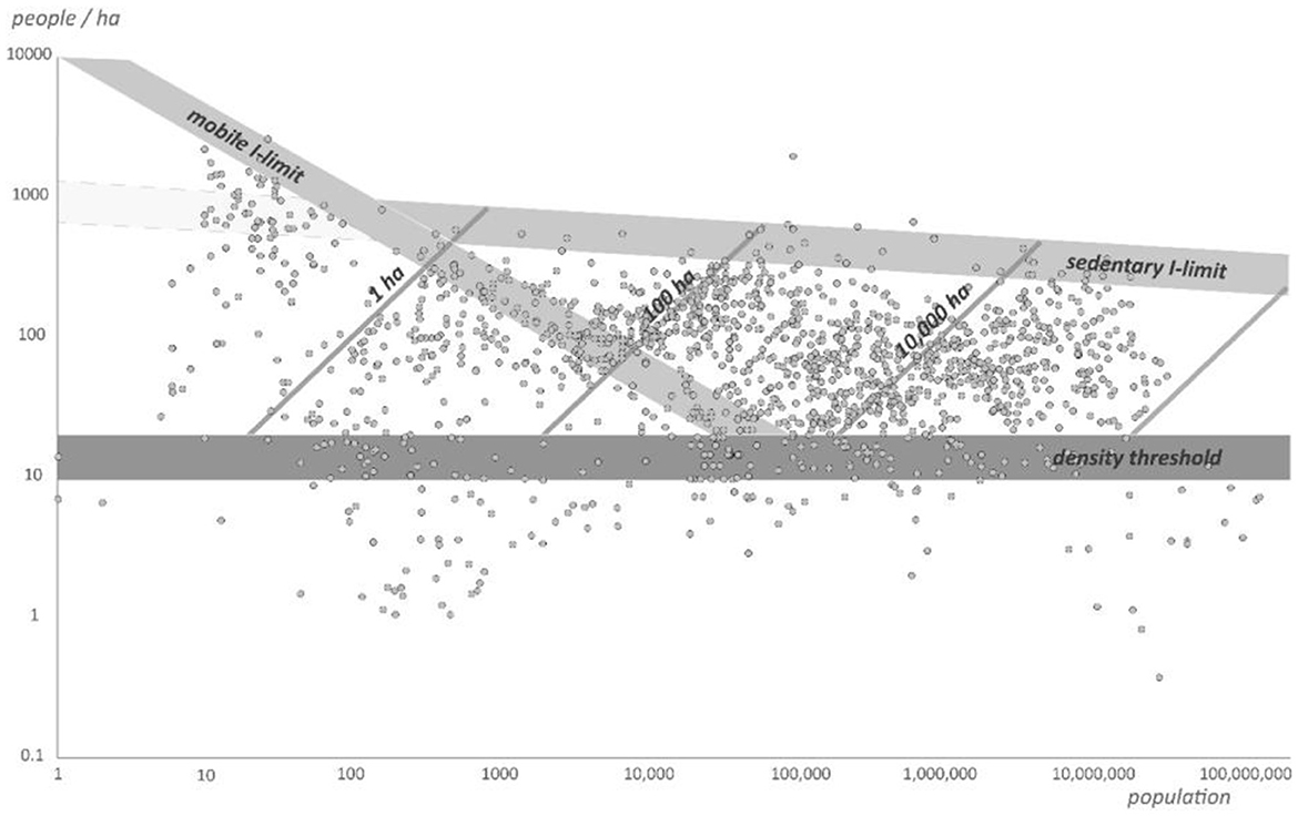
Figure 1. Interaction-communication matrix. The points are the overall density for individual settlements (see Fletcher, 1995, 2020; Fletcher and Hawken, 2021; Fletcher et al., 2021 and Supplementary Information; White and Fletcher, 2023; Image prepared by White).
In the I-C model, density is a variable in its own right. By plotting the population of settlements on the x-axis and density (population/area) on the y-axis, the diagonals of the I-C matrix are a constant area. When plotted on a diagonal of constant area, a small residential population generates a low-density, dispersed settlement, and a larger residential population produces a high-density, compact settlement. It is important to note that settlement area and residential population do not correlate. The same area of overall settlement space can carry populations ranging from small to large. Neither population nor area is a dependent variable. There is no standard residential density for any settlement size. What the I-C matrix enables is the presentation of a frame of reference in which any residential density can be plotted and can then be compared to any other residential density relative to settlement area and residential population. Each settlement size and density point can then be associated with a set of characteristics, for example, durable walling or clocks or a specific economy, and can be located in a trajectory of the successive sizes and densities of a settlement. What is important to note is that any one settlement can display a change in its residential density over time, for example, rising to higher density as it becomes larger and then dropping toward lower densities as it becomes even larger again (Figure 2).
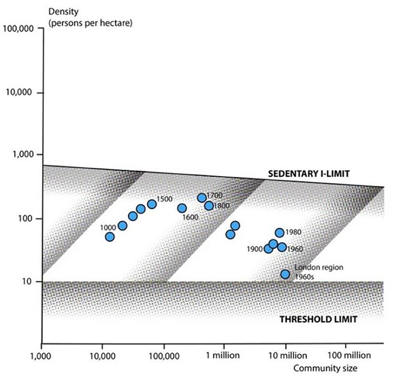
Figure 2. London. Density trajectory 1000 to 1950 CE (see Fletcher, 1995; Image prepared by White).
For the purposes of this paper population and area within settlements are used which have been provided by the work of regional specialists. A cross-cultural study of this sort must necessarily accept the data provided by regional specialists who must be presumed to be knowledgeable about the settlement sizes. This includes divergences of opinion between regional specialists (e.g., see Great Zimbabwe, cf. Huffman, 2010 and Chirikure et al., 2017). Accepting the information which has been proposed is necessary because if globalists second-guess regional specialists, they risk, first of all, being in error, and secondly, they risk the criticism that they are just modifying the figures to fit a prior globalist assumption. A globalist comment must be a review of the available regionalist data, offering an opinion about the general pattern of the data provided by regional specialists and any divergences from it or the significance of its relationship to the frame of reference provided by the I-C matrix. For example, on that basis, a global commentator might then remark that a set of population estimates are too high.
In due course, cross-regional comparison will need to be based on indices of occupation density specified in material terms, instead of population density. This will require a major, global research program to develop such indices and a lot of cross-regional discussion and dispute. However, broad observations can be made that the occupation density of a given settlement location varies from that of another. A settlement of densely packed, multi-story residential buildings can reasonably be described as having a higher occupation density than a settlement with large areas of open space between widely spaced water tanks and detached, single-story residential buildings (Figure 3). More surface area of water in numerous domestic/household water tanks per unit area of settlement space can reasonably be referred to as a feature of a denser occupation than an equivalent area with only a few scattered small tanks or one small tank or perhaps none at all (Figure 4).
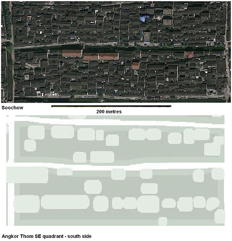
Figure 3. Dense housing in Suzhou, China in the present-day cf. distribution of water tanks (pale green) in Angkor Thom in Angkor, Cambodia, SE Asia in the twelfth-thirteenth centuries or the sixteenth century. Note: housing in Angkor Thom was in the spaces around the tanks, marked in the darker green. The houses in Angkor had one residence level raised on posts. By contrast, the houses in Suzhou are usually two-story, residential structures (Sources Google Earth and KALI lidar survey).
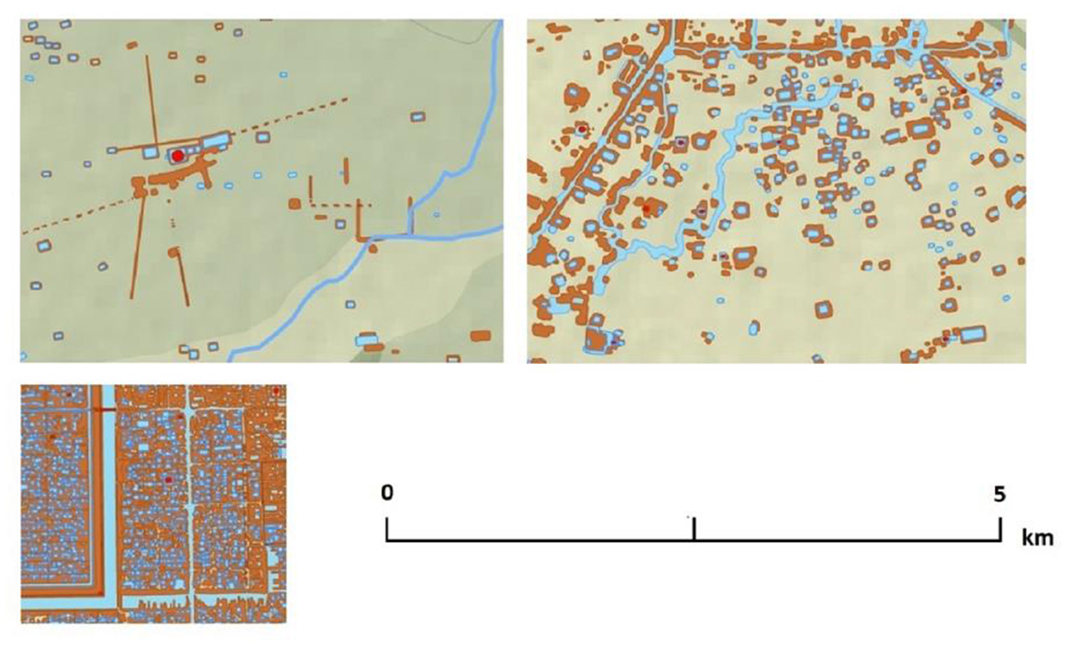
Figure 4. Dense and sparse distributions of tanks in Greater Angkor, Cambodia, SE Asia. Source is the Greater Angkor Project and the KALI lidar survey.
Low-density settlements
Conventionally, urban sprawl, the aggregate low-density dispersed urbanism of megalopolies and desa kota of the modern world, has been considered to be unique to the industrial urbanism of the past 200 years. These urban giants cover areas larger than 10,000 sq km and have reached areas as large as 400,000 sq km (Figure 5) (Fletcher and Hawken, 2021). However, there have been two other earlier sets of substantial, lower density settlements. There is an earlier trajectory to low-density, agrarian-based urbanism (e.g., see Fletcher, 2012, 2020; Graham and Isendahl, 2018) predominantly between the fourth century BCE and the fifteenth century CE. In the 1960s, the Maya cities of the Central American lowlands were the first examples of this urban form that was observed and carefully mapped (Bullard, 1960). Then, in the 1990s, they were radically referred to as “green cities” by Graham (1999), though even then they were not formally specified as low-density. A famous example is ninth century CE Tikal - which features as the rebel base in the first Star Wars movie. The class of low-density agrarian urbanism was specified from the Interaction-Communication model (Fletcher, 1995, p. 91–95; Fletcher, 2001, p. 3, 4), was initially observed in the research of Pottier (1999), and was formally identified in 2001 from NASA-JPL, space-borne, radar data on Greater Angkor (Fletcher, 2001, p. 2, 5). The circa 1000 sq km capital of the Khmer Empire in the twelfth–thirteenth century CE (Figure 6) was mapped in detail from aerial radar and air-photos, by Evans and Pottier in a collaboration which began in 2002 (Fletcher et al., 2003; see Evans et al., 2007), within its circa 3000 sq km urban region (Klassen et al., 2021).
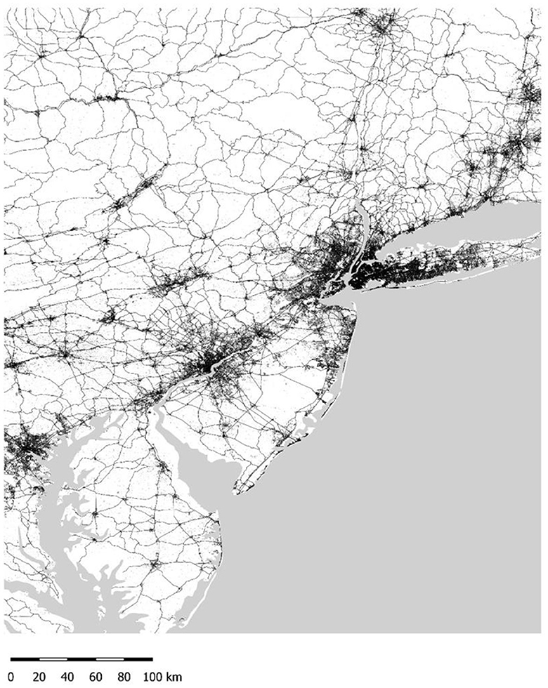
Figure 5. East Coast Megalopolis, USA, North America in the 1960s (see Fletcher and Hawken, 2021).
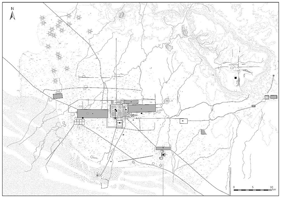
Figure 6. Greater Angkor, Cambodia, SE Asia in the twelfth-thirteenth centuries (see Fletcher and Pottier, 2021).
This class of low-density urbanism can produce settlements that exceed 100 sq km and may reach the size of Greater Angkor. They can have very low overall occupation densities, as do the modern examples which range down to overall densities of < 1 person/ha (see Figure 1 and Fletcher et al., 2021). The agrarian-based settlements have characteristic patchy, repeatedly consistent patterns of domestic occupation distributed across an agricultural landscape, so much so that Hawken (2011) refers to Greater Angkor as a “Metropolis of Rice Fields.” They do not display a hierarchy of occupation concentrations as occurs in the hinterland around a distinct, compact settlement.
The occupation areas of low-density urban settlements do, however, contain subsidiary centers (Marken and Arnauld, 2023), as can be seen very clearly in Classic Maya Caracol and in Tikal. These subsidiary centers can be linked by large routeways, whether channels and road embankments in SE Asia or raised causeways – the sacbe – in the Maya world. The central area of a large low-density city is a concentration of large, often spectacular monuments, commonly surrounded by extensive open plazas or empty spaces, and dispersed occupation further out. While the central areas of the very large settlements are obvious and the subsidiary centers are clearly visible and interconnected, smaller settlements, such as Pagan in Myanmar (Iannone, 2020), had a more distributed pattern of large and medium structures of similar size spread across the landscape. All low-density settlements merge into the overall density of their surrounding region and do not have clearly defined edges – again a characteristic which they share with their present-day counterparts.
Since 2010, another trajectory to a range of smaller low-density settlements, specified in Fletcher (1995, p. 198–203) has been recognized worldwide (Fletcher et al., 2023), from as early as the 6th millennium BCE, becoming rare after the sixteenth century CE (White and Fletcher, 2023). These were much smaller, exceeding 1 sq in extent and reaching sizes as large as 70 sq km and occasionally over 100 sq km. They existed in varied environments (Figure 7A), experienced varied climate vicissitudes, and had varied economies (White and Fletcher, 2023). Famous examples (see Fletcher et al., 2023) (Figure 7B) are Great Zimbabwe in Southern Africa (c. 1200–1700 CE), which had a mixed pastoral and agricultural economy, Cahokia in Illinois (c. 1000–1350 CE) with an agricultural and hunting basis, and the Celtic oppida of Western Europe (second century BCE–first century CE) with animal and plant agriculture. They have been referred to by varied labels, including urban, large villages, mega-sites, and anomalous giants (White, 2022, p. 43–69). In this paper, we will use the convention LLODS (Large Low Occupation Density Settlement) as it is only a descriptor and does not impute specific status or ambiguity to this diverse range of sites.
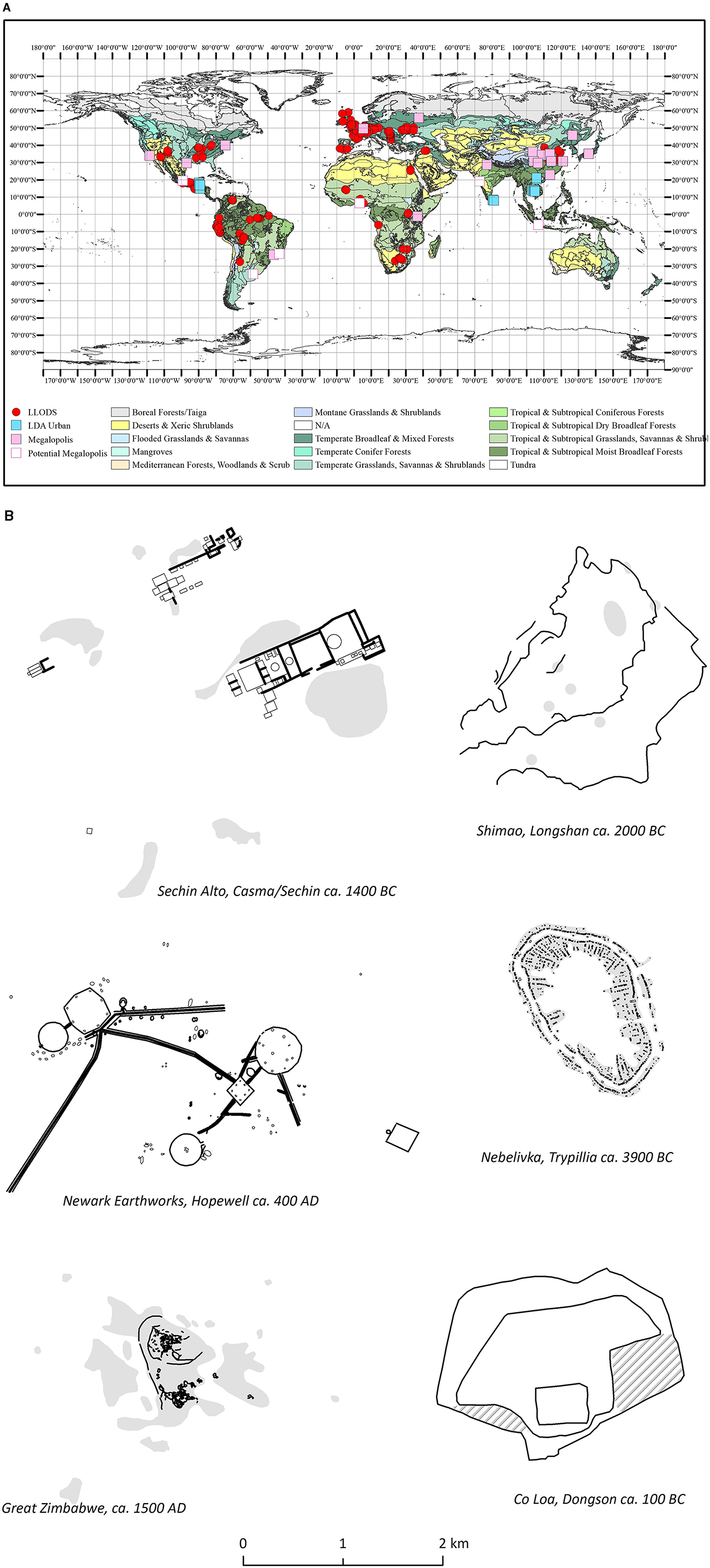
Figure 7. (A) LLODS worldwide by environment. Note Megalopolies and desa kota plotted as pink squares labeled megalopolis (Courtesy White). (B) LLODS worldwide examples of settlement plans (Courtesy White).
These three sets of lower-density settlements, the industrial-based megalopoleis - desa kota, the agrarian-based, large low-density cities, and the varied-economy-based LLODS form a band along the lower density registers of the I-C matrix (Figure 8). They contrast with the settlements which can reach much higher densities, varying in size from campsites less than a hectare in extent, to the conventionally recognized villages of agrarian sedentary communities which can frequently reach sizes up to 15–30 ha in extent, the classic compact urban settlements which can be as large as 90–100 sq km in extent, and reach densities as high as 500–600 person/ha, to the initial, compact industrial cities which began to exceed areas of more than 100 sq km at densities between about 100 and 500 person/ha. The agrarian-based forms of these higher-density settlements have displayed a capacity for long continuities, including transformations between profoundly different forms of settlement organization. Compact, conventionally defined villages have transformed into compact agrarian-based urban settlements larger than 1 sq km in different regions in both the Eastern and Western hemispheres between about 3000 BCE and the early centuries CE. Agrarian-based cities in Europe made the initial transformation to industrial-based cities in the nineteenth century. And since then, compact agrarian-based cities, all over the world, have made that change. As an epitome, Rome is conventionally known as a group of small villages before 509 BCE (Fulminante, 2014), then as a great agrarian-based capital city which then decreased in size and survived the end of its empire in the fifth century CE. In due course, it again became a major European capital from the eighth century onwards and in the nineteenth century expanded into an industrial city (Insolera et al., 2021; Kalas and van Dijk, 2021). There are substantial continuities between these varied scales and modes of compact settlement.
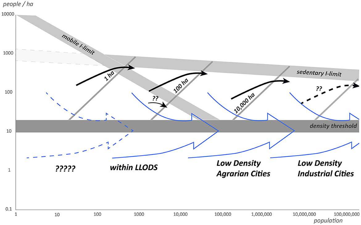
Figure 8. Band of trends of lower-density settlements on the Interaction - Communication matrix (image prepared by White).
In profound contrast, none of the modern low-density industrial cities derive from any of the agrarian-based low-density cities. All the present-day megalopoleis and desa-kota derive from much smaller, immediately antecedent, compact industrial cities. And while we know of over 200 LLODS – and there are surely many more – the great agrarian-based low-density cities that used literary, such as Angkor, did not apparently derive from a LLODS - the large form of the preceding scale of low-density settlement. And in Mesoamerica, the great Middle Pre-Classic settlements of Mirador (Hansen et al., 2022) and Kaminaljuyu (Arroyo, 2020) are about 500 and 200 km respectively from their adjacent Early Pre-Classic major Olmec (Blomster, 2017) and Mokaya sites, such as La Blanca (Love and Guernsey, 2011), displaying another form of this disjunction.
The general point to note from this big-picture overview is that low-density settlements do not appear to possess the rugged endurance which produces the continuities displayed in the networks of compact settlements. Though particular compact settlements have finite lives – for example, Uruk in Mesopotamia is now a long-abandoned place – some large compact settlements have been in use for more millennia, among them Rome, and have continued in use despite profound socio-political changes, as with Constantinople-Istanbul. In addition to this robust longevity and versatility, the networks of compact settlements are also very rugged. An obvious regional example, which has received attention from analysts of urban networks and archaeological inquiry is Western Europe (Donnelly Aquilina, 2022). Dalgaard et al. (2018) and Michaels and Rauch (2018) have remarked on and illustrated the persistence of the urban networks from the Roman Empire through to the modern world, even remarking that some French towns of Roman ancestry are now essentially in the “wrong” place (Michaels and Rauch, 2018, p. 409). And even in the British Isles, where Michaels and Rauch perceive more change than in continental Europe, the major routes and the key towns of England prior to the nineteenth century originated in the Roman Empire. The center of post-Roman London moved to the west of walled Londinium but never moved outside the Roman road nexus that converged on the town. And by the ninth century, the center of the urban area had moved back inside the Roman walls. Donnelly Aquilina (2022) has shown that although repeated change and re-configuring occurred in specific towns in Western Europe after 500 CE, the overall urban networks did not change despite profound upheaval during the migration period as the Roman Empire broke down and through the incessant changes in the political structure of Europe between the sixth and the eleventh century CE.
The demise of low-density, agrarian-based urban settlements
By contrast the networks of low-density occupation, agrarian urbanism did not persist after the demise of the major settlements. Only one low-density urban network – in Vietnam – is now known to have persisted after 1500 CE (Vo Thi Phuong et al., 2021) having commenced in the tenth century. Its main urban settlements transformed into compact industrial cities during the twentieth century. The significance of this specific regional example will be considered further in the discussion below.
In SE Asia Greater Angkor, the network of the Khmer Empire, began to decline at some time during the thirteenth and the early fourteenth century and there are no inscription records of it from 1328 until the mid-sixteenth century. Indices of activity in central Angkor began to decrease precipitously in the first half of the thirteenth century during a steep decline in the monsoons through to the mid- thirteenth century and continued to decline until stabilization during the late sixteenth century (Penny et al., 2019; Penny and Beach, 2021). The distribution of occupation across Greater Angkor contracted southwards toward the edge of the lake and the quantity of occupation indicators, in this case Chinese elite trade wares, decreased into the fifteenth century (Brotherson, 2019). This decline and the effective demise of the urban complex of Greater Angkor coincided with a period of severe climate fluctuation between mega monsoons and severe droughts from the mid-fourteenth to the early sixteenth century (Buckley et al., 2010) as the change from the Medieval Climate Anomaly to what would become the Little Ice Age accelerated (Fagan, 2008, p. 17, 43–44; Mann et al., 2009; Zhou et al., 2020). In Angkor, in the middle of the fourteenth century, the main canal that ran N-S through the urban area eroded down to more than 5 m below the former channel bed and the displaced sediment flowed southwards, filling the southern 4–5 km of the canal with more than 2 m of sand (Fletcher et al., 2017, p. 299, 300). Damage caused by this erosion and sedimentation cascaded throughout the entire water management system, shattering it functionally (Penny et al., 2018). By tradition, the elite are said to have moved southeast to the region around present-day Phnom Penh when the forces of Ayutthaya took Angkor in the early fifteenth century. Thereafter, the center of political power remained in that region.
Although the Khmer state again began to use Angkor Wat in the sixteenth century, historically, the occupation of the old central enclosure of Angkor Thom is considered to have ceased by the late sixteenth century (Groslier, 2006). Between the seventeenth and the nineteenth century, the great route network of the Khmer Empire ceased to function. The four embanked roads that connected to Angkor had, by the end of the eighteenth century, been replaced by a myriad of different routes north and south of the Tonle Sap, as recorded in the Thai Royal maps of 1801 (Figure 9A) (Santanee and Stott, 2004). In addition, the location of the post-Angkorian towns lay around the periphery of the former heartland of the Khmer Empire (Lucero et al., 2015, p. 1148, 1149). Though a movement of some people from Angkor to the south-east is recorded, as noted earlier, as yet we have no information on the dispersal of the bulk of the populace. While the effect is associated with the demise of Angkor, additional factors within the Khmer regional network, such as regional population movements, expansionist states and religious changes, were also involved (Fletcher et al., 2017, p. 305).
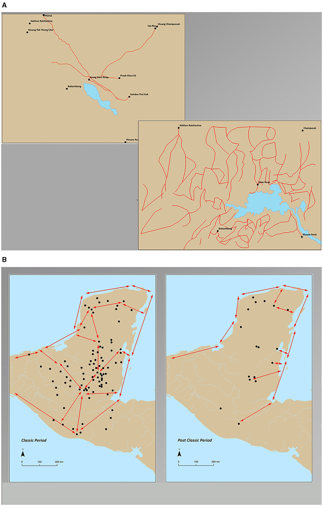
Figure 9. (A) Routes around the Tonle Sap during and after Angkor. Note different mapping conventions (after Hendrickson and Santanee and Stott; image prepared by White). (B) Mesoamerican trade route change from the Classic to the Post-Classic periods (after mayamaps; image prepared by White).
In Mesoamerica, the demise of the Classic Maya low-density cities occurred in the ninth-tenth century CE at the start of the Medieval Climate Anomaly. The demise of the Classic Maya cities has been ascribed to the impact of severe drought as the Medieval Climate Anomaly began to develop in the ninth century CE (Turner and Sabloff, 2012; Schmitt et al., 2020; Bhattacharya et al., 2023). This may be the clearest component of the fluctuating climatic conditions which occur during planetary-scale climate change. The consequent demise of the Classic Maya cities was an irregular network cascade beginning in the mid-ninth and continuing into the tenth century and is well-known as a network transformation (Figure 9B). The major cities, like Tikal and Caracol, erected their last royal stelae in the 850s and 860s (Lucero, 2003, p. 821; Tsubasa et al., 2021), though Calakmul began to break down earlier (Martin and Grube, 2000, p. 115). Some smaller places held on, some were vigorously defended and fell to extreme violence, such as Dos Pilas in the earlier ninth century (Inomata, 2008). Conflict between cities persisted through the period of decline. In the central region, the urban populations were largely gone by the mid-tenth century, with the last buildings in the mid-eleventh century as in Caracol (Chase and Chase, 2020). The concentration of settlements moved north into the Puuc apparently with a migration of people from the old heartland. Further north, Chichen Itza had declined by 1100 CE (Hoggarth et al., 2016). Thereafter, the towns of the peninsula were increasingly compact and clustered along or near the coast, with a small number inland ones on the big lakes (Lucero et al., 2015). A few places, like Lamanai (Howie, 2016), which began as a Pre-Classic (c. 2500 BCE – 200 CE) settlement, continued through to the Post-Classic (c. 950–1500 CE).
What had been riverine and inland routes within the peninsula along which trade goods were distributed, with links out to the coasts in the Pre-Classic and Classic periods, shifted to peripheral routes along the coasts, with some spur routes running a short way inland. The heartland network of the great low-density settlements of the sixth–ninth-tenth centuries faded away and was replaced by compact settlements predominantly around the periphery, engaging with maritime trade (Golitko et al., 2012).
For Sri Lanka, the role of weather and climate in the demise of the dispersed urban complex of Anuradhapura is less clear, though the same pattern of regional urban dispersal is apparent. An already weakened Anuradhapura was invaded by the Cholas in the mid-ninth and the early tenth century, with the final defeat occurring in the late tenth century (Strickland, 2017, p. 149). While this overlaps with the general period of temperature increase at the start of the Medieval Climate Anomaly, a clear association to a period of severe unstable climate change is not yet definitive. What is clear, however, is that the demise of Anuradhapura, followed by the short ascension and then the demise of Polonnaruva (Manuel et al., 2021), ended the era of major urban occupation of the Dry Zone of Sri Lanka.
Interestingly, Manuel et al. (2021) have shown that Polonnaruva, which developed in the twelfth century CE after the demise of Anuradhapura, had components of such a hierarchical pattern of occupation, in contrast to Anuradhapura which does not display such a size hierarchy within its several 100 sq km area (Coningham and Gunawardhana, 2013). This suggests that after the demise of the low-density, dispersed urban form at Anuradhapura, the Sinhalese began to move toward the more compact, regionally differentiated urban form, though still within an overall lower-density form.
In the following centuries, the urban centers of the island moved into the more mountainous south and out to the coasts in the northern and southern halves of the island. The old urban heartland located in the low-lying, center-north of the island was replaced by dominantly peripheral towns on the coasts (Lucero et al., 2015) and later by the establishment of Kandy in the fifteenth–sixteenth century, inland up in the mountains, as the capital of the Kingdom of Kandy. The regional network of Sri Lanka shifted to a coastal focus with inland connections, moving further south, away from the old network centered on the old Buddhist capital heartland (Lucero et al., 2015).
What we can see in SE Asia, and as discussed below in Mesoamerica and in Sri Lanka, is a dispersal of urbanism away from the old centers (Figure 10A) (Lucero et al., 2015). The demise of major, agrarian-based low-density urban settlements in three separate regions of the world generated the demise of the entire network in each region of which they were part. In the two cases where a detailed analysis of climate proxies has been carried out, Mesoamerica and SE Asia, the impact of severe climate instability has been implicated (Lucero et al., 2015). In Sri Lanka, the definitive proxies are not yet available. However, the demise of the Buddhist cities does coincide with the start of the Medieval Climate Anomaly and therefore was liable to have occurred in a period of severe climate instability.
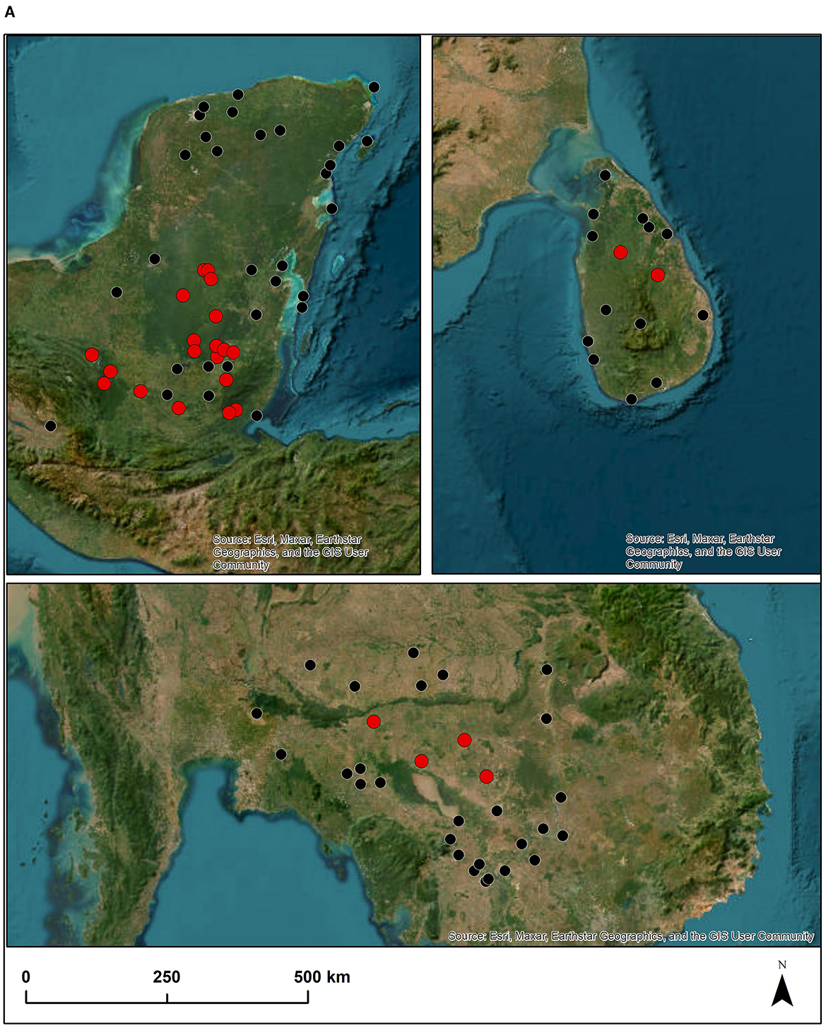
Figure 10. (A) Agrarian low-density heartland abandonment in SE Asia, Sri Lanka and lowland Mesoamerica. Red dots – the largely abandoned, heartland low-density cities. Black dots – the later, compact peripheral, small, compact urban settlements (after Lucero et al., 2015; Image prepared by White). (B) Industrial low-density risk – a future of heartland abandonment imposed on the current planetary urban light signature. The arcs are a schematic representation of peripheral re-location zones for the post, low-density settlements (Source for base image – NASA).
While unstable climate may be ascribed a consequential role, it is important to note both that the specific socio-political effects were not determined by the climate and that they were different in each region. Furthermore, the royal-based Khmer state survived the demise of its more than 1 million sq km empire, retained the continuity of its traditions and literacy, and continued to rule Cambodia through vicissitudes of internal conflict and external attack to the present day. There was no collapse of Khmer civilization despite the demise of its largest, agrarian-based low-density city. While the society was resilient, the experience of the fourteenth and fifteenth centuries cannot have been pleasant. In Sri Lanka, the land area dominated by Anuradhapura of about 65,000 sq km had fragmented into numerous small political units by the fifteenth century (De Silva, 2005). In this case, the old ruling elite lost its dominance and there was no long-term continuity of its political power. However, new ruling political elites did appear, and the traditions and literacy of the Tamils and the Sinhalese continued. By contrast, the demise of the small Maya states with maximum areas of ~500–700 sq km led to the disappearance of the ruling families and, in due course, to the disappearance of states and kings throughout the interior of the peninsula. Small political entities continued along the coasts and around the big inland lakes and some knowledge of the glyphic script of the Classic period continued into the period of Spanish colonization in the sixteenth–seventeeth century, though in many areas it had ceased to be used (Jones, 1998; Fry, 2001).
Significance
The impact of severe climate change on the great agrarian low-density cities was not deterministic. Though the heartland networks ceased to operate and were superseded by new networks connected to the former periphery of the heartland, this material condition did not correlate with one form of socio-political transformation. The people in each cultural tradition made their own unique way into their future. Because great cities cease and their regional networks are markedly reconfigured does not mean that the socio-political systems that operated with them will also fail. Instead, the outcomes in each region were demonstrations of human versatility and the creative consequences of human agency, very likely in difficult circumstances.
This reality is vigorously demonstrated by the endurance of the low-density state, regional capitals, and the socio-political structure of the Vietnamese between the tenth and nineteenth century CE. After the Chinese domination of the region around the Red River delta from 111 BCE to the tenth century CE, the Vietnamese broke free and established a new capital at Hua Lu in 968 CE (Vo Thi Phuong, 2022). From then, until the establishment of Hue in the nineteenth century, the Vietnamese created large cities with central enclosed areas, referred to as citadels, surrounded by extensive, irregular enclosures which were delimited by combinations of embankments, modified natural water channels, and natural rivers. What is crucial is that this low-density urban form persisted through the climate instability of the fourteenth and fifteenth centuries. Since this instability was identified in the tree rings of the Fokeinia cypress in Vietnam (Buckley et al., 2010), the climate impact must have been substantial along the eastern side of mainland SE Asia, as well as further to the west.
Plainly, specific circumstances or socio-political behavior can affect the degree to which severe climate change will have an impact. There are perhaps some clues in the archaeological record. The most obvious is that the largest socio-political entity, the Khmer Empire, appears to have provided Khmer state power with some resilience or leeway to cope with its changing circumstances. By contrast, the Vietnamese large settlements (Vo Thi Phuong et al., 2021) had a different and distinct advantage in the post-fifteenth century world because they - unlike the other tropical-environment, low-density cities which were far inland - were established near the coast from the tenth century onwards. Furthermore, the population of the coasts of modern Vietnam, the Chams in the center-south and the Vietnamese in the north, already had well-established maritime trade connections (see Do Truong, 2016). In mainland SE Asia, after the fifteenth century, other major urban settlements were relocating nearer to the coasts and the new trade opportunities which was stimulated by the arrival of the European traders (Reid, 1993). The new Vietnamese capitals were already in place. Therefore, in future research, the fourteenth and fifteenth century capitals, primarily Thang Long (modern Hanoi), become a crucial test of the degree to which the fourteenth-fifteenth century climate crisis adversely affected them but in the absence of additional factors encouraging relocation, they were able, socio-politically, to stay in place and outlast the crisis. The past provides many, varied lessons which need to be brought together.
Implications
The past tells us that a severe climate crisis can be an extreme risk for low-density settlements and their regional networks, and also that very specific circumstances may facilitate the resilience of societies coping with such risk. While we are not, therefore, inevitably doomed by the impact of unstable climate change on industrial-based, low-density urbanism, we should consider the implications of what we now know. The consequences could potentially be very serious, the resilience of our societies worldwide may be threatened and though humankind is likely to survive, the experience could be harrowing and fatal for millions of people. There is a potentially serious threat that our low-density cities may lack resilience, and if they begin to break down, we risk the demise of entire regional networks and a profound relocation of urban settlements which may be taking up a new compact form. If this risk has some probability, its consequences would be so severe that we might seriously consider the need for remedial action – though what that might be is, itself, problematic.
We know from the large-scale disjunction between the three magnitudes of low-density settlement that previous low-density forms have not had transformational futures. They did not develop into the next magnitude of the same spatial form of settlement (see Figure 8). They rarely transformed into any other substantial settlement form, though the LLODS predecessors of the nineteenth century Yoruba towns of Nigeria are a notable and rare exception (White and Fletcher, 2023). The implication is that our current, giant, low-density megalopoleis and desa kota may also be a terminal phenomenon. They may persist for some time. Previous low-density giant settlements and their networks were capable of long durations (White and Fletcher, 2023). But they may not possess the capacity to endure and transform, especially if they are vulnerable to the impact of severe climate variability and change. In the case of the industrial giants, the immediate risk would be due to the potential consequences of rising sea level on urban infrastructure, such as the New York or Tokyo underground railways.
Almost all the megalopoleis and desa kota are at sea level. If, therefore, the rising sea level took out transport infrastructure and the giant cities began to break down, we have to envisage that a cascade effect would begin that propagates through the regional network links between cities connected to the low-density giants. If the consequent changes occur in the same way as the movement of urbanism out to the periphery of the existing heartlands of the agrarian low-density giants, the operational consequences would be dire (Figure 10B). If the largest low-density cities and their networks break down, then the east coasts of the USA, China, and Japan, the North Sea coasts of Europe, and the islands of SE Asia would suffer a massive decline in their urban landscape. And new arcs of urban centers, presumably more compact, if again the agrarian low-density regional demise is repeated, would re-form hundreds of kilometers further inland, re-making the economic and socio-political landscape of their world.
Conclusions
If the apparent vulnerabilities of the agrarian low-density cities and their networks are repeated, due to the impact of global warming on our present-day, industrial urban giants, the implication is that the damage would not be restricted just to the major megalopoleis and desa kota. That alone might be manageable. Instead, if the effect propagates throughout their regional networks, the socio-political and economic consequences would be very severe, creating radically different regional urban landscapes and profound changes to the routes which connect our world. To assess whether this might occur, we have to depend upon an analysis of our past experience, the record of what has happened to our settlements over the previous 7,000 to 8,000 years. As well as further assessment of the settlement trajectories in Mesoamerica, South Asia, and SE Asia, we now also need additional information about the more than 200 smaller, lower-density settlements, recently referred to as the Anomalous Giants all over the world, across that timespan. We can use these settlements to further assess the degree to which their demise significantly intersected with severe climate change, the degree to which they did not generate new, cultural traditions with the same settlement form, and the degree to which their settlement networks did not persist. A critical test is available to allow us to assess what risks our gleaming and dirty industrial, sprawling giant cities and their regions may face.
Data availability statement
Publicly available datasets were analyzed in this study. This data can be found at: Supplementary data attached to paper by RF, KW, and Dhamendra, “The Naming of Parts: Integrating Urban Difference.” 2022 Journal of Urban Archaeology 5.
Author contributions
RF: Conceptualization, Funding acquisition, Investigation, Methodology, Project administration, Writing – original draft. KW: Data curation, Visualization, Writing – review & editing. DP: Investigation, Methodology, Writing – review & editing.
Funding
The author(s) declare financial support was received for the research, authorship, and/or publication of this article. The funding of the research for this paper was provided by the Australian Research Council Discovery grant scheme for the Greater Angkor Project. The funding for additional research and the collaborative meetings from which this paper derives were funded by The University of Sydney -The University of Edinburgh Partnership Collaboration Awards in 2022–23.
Acknowledgments
The work and the research reported in this paper derives from many years of collaboration with many colleagues world-wide. My thanks to all the members of the research teams of the Greater Angkor Project and to my numerous colleagues in the universities and museums where I have been fortunate to spend productive times as a visiting researcher over many years. My especial thanks to colleagues and friends who have had a major role in the development of this paper and the issues it considers. First and particularly to KW and DP my co-authors. To Christophe Pottier my profound thanks for many years of friendship and working together in Angkor. To Lisa Lucero and Robin Coningham and Scott Hawken for the work on the prospects of low-density urbanism. To John Chapman and Bisserka Gaydarska for many years of discussion and debate about the Tripyllia sites. To the staff and directors of Para Limes at Nayang University, the Amerind Foundation, the University of Durham Institute of Advanced Study and Urbnet at Aarhus University my deep appreciation of the opportunities they gave me to think about low-density urbanism and its implications for our future. The University of Sydney has given me a life-long opportunity to carry out this research and the place where I have found the colleagues and friends needed for me to do it.
Conflict of interest
The authors declare that the research was conducted in the absence of any commercial or financial relationships that could be construed as a potential conflict of interest.
The author(s) declared that they were an editorial board member of Frontiers, at the time of submission. This had no impact on the peer review process and the final decision.
Publisher's note
All claims expressed in this article are solely those of the authors and do not necessarily represent those of their affiliated organizations, or those of the publisher, the editors and the reviewers. Any product that may be evaluated in this article, or claim that may be made by its manufacturer, is not guaranteed or endorsed by the publisher.
References
Arroyo, B. (2020). “The Maya highlands and the late preclassic: kaminaljuyu as a case study,” in The Maya World, eds. S. Hutson and T. Ardren (London: Routledge), 81–101.
Bhattacharya, T., Krause, S., Penny, D., and Wahl, D. (2023). Drought and water management in ancient Maya society. Prog. Phys. Geography Earth Environ. 47, 189–204. doi: 10.1177/03091333221129784
Blomster, J. P. (2017). The Early Olmec and Mesoamerica: The Material Record. Cambridge: Cambridge University Press.
Brotherson, D. J. (2019). Commerce, the Capital, and Community: Trade Ceramics, Settlement Patterns and Continuity Throughout the Demise of Angkor. PhD Thesis. Sydney, NSW: The University of Sydney.
Buckley, B. M., Anchukaitis, K. J., Penny, D., Fletcher, R., Cook, E. R., Sano, M., et al. (2010). Climate as a contributing factor in the demise of Angkor, Cambodia. PNAS 107, 6748–6752. doi: 10.1073/pnas.0910827107
Bullard, W. R. (1960). Maya settlement pattern in Northeastern Petén, Guatemala. Am. Antiq. 25, 355–372. doi: 10.2307/277519
Chase, A. F., and Chase, D. Z. (2020). Final moments: contextualizing on-floor archaeological materials from Caracol, Belize. Ancient Mesoam. 31, 77–87. doi: 10.1017/S0956536119000063
Chirikure, S., Moultrie, T., Bandama, F., Dandara, C., and Manyanga, M. (2017). What was the population of Great Zimbabwe (CE1000 - 1800)? PLoS ONE 12:e0178335. doi: 10.1371/journal.pone.0178335
Coningham, R., and Gunawardhana, P. (2013). Anuradhapura III: The Hinterland. BAR International Series 2568. Oxford: BAR.
Dalgaard, C. J., Kaarsen, N., Olsson, O., and Selaya, P. (2018). Roman Roads to Prosperity: Persistence and Non-Persistence of Public Goods Provision. CEPR Discussion Paper Series, DP12745.
Do Truong, G. (2016). Diplomacy, trade and networks: champa in the asian commercial context (7th-10th centuries). Social Sci. Res. SE Asia 27, 59–82. doi: 10.4000/moussons.3521
Donnelly Aquilina, H. (2022). The Significance of Continuities in Post-Roman Urbanism in Western Europe (5th-10th Century) from a Global Perspective. PhD Thesis. Sydney, NSW: The University of Sydney.
Evans, D., Pottier, C., Fletcher, R., Hensley, S., Tapley, I., Milne, A., et al. (2007). A comprehensive archaeological map of the world's largest pre-industrial settlement complex at Angkor, Cambodia. PNAS 104, 14277–14282. doi: 10.1073/pnas.0702525104
Fletcher, R. (2012). “Low-density, agrarian-based urbanism: Scale, power, and ecology,” in The Comparative Archaeology of Complex Societies, ed. M. E. Smith (Cambridge: Cambridge University Press), 285–320.
Fletcher, R., Buckley, B. M., Pottier, C., and Wang, S. Y. S. (2017). “Fourteenth to Sixteenth Centuries AD: the case of angkor and monsoon extremes in mainland Southeast Asia,” in Megadrought and Collapse: From Early Agriculture to Angkor, ed. H. Weiss (New York, NY: Oxford Academic),275–314.
Fletcher, R. J. (1995). The Limits of Settlement Growth. A Theoretical Outline. Cambridge: Cambridge University Press.
Fletcher, R. J. (1999). “Appraising the urban future: an archaeological time perspective,” in Time and Archaeology, ed. T. Murray (London: Routledge), 88–108.
Fletcher, R. J. (2018). “Sprawl at risk,” in Disrupted Balance. Society at Risk, ed. J. W. Vasbinder (Singapore: World Scientific Press), 48–51. doi: 10.1142/9789813239227_0011
Fletcher, R. J. (2020). Urban labels and settlement trajectories. J. Urb. Archaeol. 1, 31–48. doi: 10.1484/J.JUA.5-120877
Fletcher, R. J., Dharmendra, B., and White, K. (2021). The naming of parts: integrating urban difference. J. Urb. Archaeol. 5, 33–64. doi: 10.1484/J.JUA.5.129842
Fletcher, R. J., Evans, D., Barbetti, M., Penny, D., and Pottier, C. (2003). Redefining Angkor: structure and environment in the largest, low-density urban complex of the pre-industrial world. UDAYA 4, 107–121.
Fletcher, R. J., and Hawken, S. (2021). Dispersed urbanism: past and present. J. Urban Archaeol. 3, 29–50. doi: 10.1484/J.JUA.5.123674
Fletcher, R. J., and Pottier, C. P. (2021). “Angkor: a provisional map history of greater angkor from ancestry to transformation,” in The Oxford Handbook of Early Southeast Asia (Chapter 31), eds. C. F. W. Higham and N. C. Kim (New York, NY: Oxford University Press), 721–49.
Fry, R. (2001). “Postclassic Maya,” in Encyclopedia of Prehistory, eds. P. N. Peregrine and M. Ember (Boston, MA: Springer), 353–360.
Fulminante, F. (2014). The Urbanisation of Rome and Latium Vetus. Cambridge: Cambridge University Press.
Golitko, M., Meierhoff, J., Feinman, G. M., and Williams, P. R. (2012). Complexities of collapse: the evidence of Maya obsidian as revealed by social network graphical analysis. Antiquity 86, 507–523. doi: 10.1017/S0003598X00062906
Graham, E. (1999). “Stone cities, green cities,” in Complex Polities in the Ancient Tropical World eds. E. A. Bacus and L. J. Lucero (Washington, DC: American Anthropological Association), 185–194.
Graham, E., and Isendahl, C. (2018). “Neotropical cities as agro-urban landscapes: revisiting ‘low-density, agrarian-based urbanism',” in The Resilience of Heritage: Cultivating a Future of the Past: Essays in Honour of Professor Paul J.J. Sinclair, eds. A. Ekblom, C. Isendahl and K.-J. Lindholm (Uppsala: Uppsala Universitet),165–180.
Groslier, B. P. (2006). Angkor and Cambodia in the Sixteenth Century. According to Portuguese and Spanish Sources. Bangkok: Orchid Press.
Hansen, R. D., Morales-Aguilar, C., Thompson, J., Ensley, R., Hernández, E., Schreiner, T., et al. (2022). LiDAR analyses in the contiguous Mirador-Calakmul Karst Basin, Guatemala: an introduction to new perspectives on regional early Maya socioeconomic and political organization. Ancient Mesoam. 22, 1–40. doi: 10.1017/S0956536122000244
Hawken, S. (2011). Metropolis of Rice Fields: A Topographic Classification of a Dispersed Urban Complex. PhD Thesis. Sydney, NSW: The University of Sydney.
Hoggarth, J. A., Breitenbach, S. F., Culleton, B. J., Ebert, C. E., Masson, M. A., Kennett, D. J., et al. (2016). The political collapse of Chichen Itza in climatic and cultural context. Global Planetary Change 138, 25–42. doi: 10.1016/j.gloplacha.2015.12.007
Howie, L. (2016). Ceramic Change and the Maya Collapse: A Study of Pottery Technology, Manufacture and Consumption at Lamanai, Belize. Oxford: BAR Publishing.
Huffman, T. N. (2010). Revisiting great Zimbabwe. Azania: Archaeol. Res. Africa 45, 321–328. doi: 10.1080/0067270X.2010.521679
Iannone, G. (2020). “Entanglement and disentanglement at the medieval capital of Bagan, Myanmar,” in Detaching From Place: A World Archaeology Perspective to Settlement Abandonment, eds L.-S.-H. Maxime and A. M. Scott (Boulder, CO: University Press of Colorado), 164–177.
Inomata, T. (2008). Warfare and the Fall of a Fortified Center: Archaeological Investigations at Aguateca. Nashville, TN: Vanderbilt University Press
Insolera, I., Berdini, P., and De Lucia, V. (2021). Modern Rome: From Napoleon to the Twenty-First Century. Newcastle upon Tyne: Cambridge Scholars Publishing.
Jones, G. D. (1998). The Conquest of the Last Maya Kingdom. Stanford, CA: Stanford University Press. doi: 10.1515/9780804779326
Kalas, G., and van Dijk, A. (2021). Urban Developments in Late Antique and Medieval Rome. Revising the Narrative of Renewal. Amsterdam: Amsterdam University Press.
Klassen, S., Carter, A. K., Evans, D., Ortman, S. G., Stark, M. T., Loyless, A. A., et al. (2021). Diachronic modelling of the population within the medieval Greater Angkor Region settlement complex. Sci. Adv. 7:eabf8441. doi: 10.1126/sciadv.abf8441
Love, M., and Guernsey, J. (2011). “La Blanca and the soconusco middle formative,” in Early Mesoamerican Social Transformations. Archaic and Formative Lifeways in the Soconusco Region, ed. R. G. Lesure (Berkeley, CA: University of California Press.), 170–188.
Lucero, L. (2003). The collapse of the classic maya: a case for the role of water control. Am. Anthropol. 104, 814–826. doi: 10.1525/aa.2002.104.3.814
Lucero, L., Fletcher, R., and Coningham, R. (2015). From 'collapse' to urban diaspora: the transformation of low-density, dispersed agrarian urbanism. Antiquity 89, 1139–1154. doi: 10.15184/aqy.2015.51
Mann, M. E., Zhang, Z., Rutherford, S., Bradley, R. S., Hughes, M. K., Shindell, D., et al. (2009). Global signatures and dynamical origins of the little ice age and medieval climate anomaly. Science 326, 1256–1260. doi: 10.1126/science.1177303
Manuel, M., Gunawardhana, P., Namalgamuwa, H., Coningham, R. A. E., Davis, C., Rammungoda, U. R., et al. (2021). Low density urbanism in medieval Sri Lanka: exploring the Hinterland of Polonnaruva. Asian Persp. 60, 248–271. doi: 10.1353/asi.2021.0002
Marken, D. B., and Arnauld, M. C. (2023). Building an Archaeology of Maya Urbanism. Planning and Flexibility in the American Tropics. Denver, CO: University Press of Colorado.
Martin, S., and Grube, N. (2000). Chronicle of the Maya Kings and Queens: Deciphering the Dynasties of the Ancient Maya. London: Thames and Hudson.
Michaels, G., and Rauch, F. (2018). Resetting the urban network: 117-2012. The Econ. J. 128, 178–412. doi: 10.1111/ecoj.12424
Penny, D., and Beach, T. P. (2021). Historical socioecological transformations in the global tropics as an Anthropocene analogue. PNAS 118:e2022211118. doi: 10.1073/pnas.2022211118
Penny, D., Hall, T., Evans, D., and Polkinghorne, M. (2019). Geoarchaeological evidence from Angkor, Cambodia, reveals a gradual decline rather than a catastrophic 15th-century collapse. Proc. Nat. Acad. Sci. 116, 4871–4876. doi: 10.1073/pnas.1821460116
Penny, D., Zachreson, C., Fletcher, R., Lau, D., Lizier, J. T., Fischer, N., et al. (2018). The demise of Angkor: systemic vulnerability of urban infrastructure to climatic variations. Sci. Adv. 4:eaau4029. doi: 10.1126/sciadv.aau4029
Pottier, C. P. (1999). Carte Archéologique de la Région d'Angkor. Zone Sud. (PhD Thesis). Paris: UFR Orient et Monde Arab. Universite Paris III - Sorbonne Nouvelle.
Reid, A. (1993). Southeast Asia in the Age of Commerce 1450–1680, Vol. 2. Expansion and Crisis. Bangkok: Silkworm Books.
Santanee, P., and Stott, P. A. (2004). Royal Siamese Maps: War and Trade in Nineteenth Century Thailand. Bangkok: River Books.
Scheffer, M., Bascompte, J., Brock, W. A., Brovkin, V., Carpenter, S. R., Dakos, V., et al. (2009). Early warning signals for critical transitions. Nature 461, 53–59. doi: 10.1038/nature08227
Schmitt, D., Gischler, E., Birgel, D., Peckmann, J., Anselmetti, F. S., Vogel, H., et al. (2020). Great Blue Hole (Lighthouse Reef, Belize): a continuous, annually-resolved record of common era sea surface temperature, Atlantic multidecadal oscillation and cyclone-controlled run-off. Quaternary Sci. Rev. 247:106570. doi: 10.1016/j.quascirev.2020.106570
Strickland, K. M. (2017). A Time of Change: Questioning the Collapse of Anuradhapura, Sri Lanka. Oxford: Archaeopress.
Tsubasa, O., Chase, A. F., Nondédéo, P., and Arnauld, M. C. (2021). Maya Kingship: Rupture and Transformation from Classic to Postclassic Times. Gainesville, FL: University of Florida Press.
Turner, I. I. B. L., and Sabloff, J. (2012). Classic Period collapse of the Central Maya Lowlands: Insights about human–environment relationships for sustainability. Proc. Nat. Acad. Sci. 109, 13908–13914. doi: 10.1073/pnas.1210106109
United Nations Department of Economic and Social Affairs (UN DESA) (2018). Revision of World Urbanization Prospects. Available online at: https://www.un.org/development/desa/en/news/population/2018-revision-of-world-urbanization-prospects.html (accessed April 7, 2023).
Vo Thi Phuong, T. (2022). The Urban Landscape of Hoa Lu During the Tenth Century (PhD Thesis). Taiwan: National Dong Hwa University.
Vo Thi Phuong, T., Fletcher, R. J., and Ying-San, L. (2021). Extensive, low-density Vietnamese urban settlements - 10th to 19th century CE: redefining ancestry and organization in a Southeast Asian urban tradition. World Archaeol. 53, 345–368. doi: 10.1080/00438243.2021.2002717
White, K. (2022). From Trypillia to Tswana: A Global Perspective on Giant Low-Density Settlements. PhD Thesis. Sydney, NSW: The University of Sydney.
White, K., and Fletcher, R. J. (2023). Anomalous Giants: form, operation, differences and outcomes. J. Urb. Archaeol. 7, 275–311. doi: 10.1484/J.JUA.5.133459
Keywords: low-density settlements, urbanism, risk, climate change, outcomes
Citation: Fletcher R, White K and Penny D (2024) Risk and low-density dispersed urbanism. Front. Hum. Dyn. 6:1347157. doi: 10.3389/fhumd.2024.1347157
Received: 30 November 2023; Accepted: 11 March 2024;
Published: 15 May 2024.
Edited by:
Dries Daems, VU Amsterdam, NetherlandsReviewed by:
Francesca Fulminante, University of Bristol, United KingdomChristian Isendahl, University of Gothenburg, Sweden
Rodrigo Solinis-Casparius, University of Illinois Chicago, United States
Copyright © 2024 Fletcher, White and Penny. This is an open-access article distributed under the terms of the Creative Commons Attribution License (CC BY). The use, distribution or reproduction in other forums is permitted, provided the original author(s) and the copyright owner(s) are credited and that the original publication in this journal is cited, in accordance with accepted academic practice. No use, distribution or reproduction is permitted which does not comply with these terms.
*Correspondence: Roland Fletcher, cm9sYW5kLmZsZXRjaGVyQHN5ZG5leS5lZHUuYXU=