 Kunzes Angmo
 Bhupendra S. Adhikari2
 Gopal S. Rawat
94% of researchers rate our articles as excellent or good
Learn more about the work of our research integrity team to safeguard the quality of each article we publish.
Find out more
ORIGINAL RESEARCH article
Front. For. Glob. Change, 20 March 2025
Sec. Forest Management
Volume 8 - 2025 | https://doi.org/10.3389/ffgc.2025.1481219
This article is part of the Research TopicStructure and Functioning of Alpine Treeline EcosystemsView all 5 articles
Introduction: The Himalayan region is home to a rich array of wild medicinal plants that play a vital role in providing livelihoods and health security of the local communities. However, excessive exploitation of these plant resources driven by the growing demand from the market has resulted in rapid decline in several plant species. In this paper we provide the quantitative information on the population status and distribution pattern of the species frequently harvested from the wild in Western Ladakh, Indian Trans-Himalaya.
Methodology: A Conservation Priority Score (CPS) was used to rank the species according to their density, frequency, usage diversity, and extractive pressure. We generated distribution maps of key species with the help of participatory rural appraisal (PRA) and field surveys. GIS was used to create a habitat suitability map. The survey areas were divided into four suitability classes based on aspects, degree of slope, and land use/cover. In order to guide conservation efforts, the distribution and usage patterns of medicinal plants were recorded, and the model’s accuracy was assessed using the Boyce index.
Results: Of the 84 species of medicinal plants 33 species fall under the category I (high priority) and 51 in category II. The majority of category I species were found in Wakha-chu (14 species), Suru (18 species) and the Lower Indus (19 species) valley. Valley High conservation priority species have very limited biomass available for harvesting as indicated by their low density and regeneration. Species in greater demand exhibit low density (0.01 to 12.6 individuals per m2). Highly traded species have been compared in terms of wide and narrow distribution range.
Conclusion: Several high priority species are facing the risk of local extinction in the study area. Therefore, there is an urgent need to initiate community led conservation action including closure of certain sites for extraction for a few years, fixing the limits of harvest and self-regulated rotational harvest for other areas. Local healers, ecologists and local communities need to come on same platform to evolve sustainable harvest plans and initiate long term monitoring following citizen science approach.
Indigenous ethnic communities in many parts of the world especially in developing countries depend on wild medicinal plants for their health care and to earn cash income by selling them in market (Ved and Goraya, 2007; Kumar et al., 2021; Mishra et al., 2023). Dependence of local communities on the wild medicinal plants is particularly high in far flung areas of Himalayan mountains where modern health facilities are lacking but the local communities inherit a considerable traditional knowledge on the use of such plants (Rana and Rawat, 2024). It is seen that most of the high-altitude medicinal plants are slow growing and take a long time to mature due to a short growing season and harsh climatic conditions (Chandra et al., 2021). Over and premature harvest of medicinal plants from wild and resultant decline in their populations have been reported by several authors, (e.g., Jishtu et al., 2021; Gupta et al., 2013; Samant et al., 2007). Impact of extraction pressure is especially severe on the species in which roots, tubers or rhizomes used as medicine.
Ladakh, situated in the western Trans-Himalaya, harbors a wealth of wild medicinal plants that have long been integral to local traditions and commercial markets. Yet, unsustainable harvesting practices, driven by rising market demand, have caused rapid decline of populations of several high value species, necessitating urgent conservation efforts (Kala, 2005; Negi et al., 2018). Despite their ecological and economic importance, comprehensive data on species availability, use patterns, and conservation priorities remain scarce.
The challenges of effective conservation in the region are compounded by the lack of sufficient resources and tailored strategies. While several studies emphasize the importance of prioritizing species based on ecological, cultural, and economic criteria (Heywood and Dulloo, 2005; Diaz et al., 2020), a significant research gap persists in integrating these factors into actionable conservation frameworks specific to the region. Furthermore, past prioritization methodologies often lack consistency and fail to incorporate harvesting dynamics, population trends, and spatial distribution (Schwartz et al., 2018). Addressing these gaps requires detailed field investigation including patterns of extraction, availability in the wild using participatory resource mapping. Rugged terrain and remote locations of Indian Trans-Himalaya often pose challenges for detailed assessment of plant populations in the field. Hence, knowledge on the habitat and altitudinal range coupled with use of remote sensing and Geographic Information System (GIS) helps in preparing distribution maps of the species and predicting suitable habitats. GIS-based approaches, combined with ecological niche modeling based on environmental correlates such as topography, eco-climatic conditions and soil type help in preparing distribution maps (Phillips et al., 2006). Recent studies have highlighted the utility of GIS in biodiversity conservation, particularly in data-deficient regions (Kumar and Stohlgren, 2009; Underwood et al., 2018; Uddin et al., 2019). However, such applications remain underexplored in Ladakh, underscoring the need for site-specific geospatial analyses to inform conservation planning.
This research fills these gaps by categorizing medicinal plant species based on their harvesting potential and conservation priorities while mapping their distribution ranges using GIS. The objectives of the study were (i) to develop an integrated framework for prioritizing medicinal plant species for conservation in the western Ladakh, (ii) to map the spatial distribution of prioritized species using participatory process coupled with ecological and geo-spatial tools.
The findings will provide critical insights into balancing biodiversity conservation with sustainable resource management, ensuring the long-term preservation of Ladakh’s ethnobotanical heritage.
The study was conducted in Kargil district and also some parts of Leh districts of Ladakh. The study area falls within Indian Trans-Himalaya and is known for its unique biodiversity assemblages as flora, fauna, human resources, land, energy, and minerals. The study area is located between 32°44′ to 37°08′ North latitudes and 72°50′ to 80°23′ East longitudes. The three parallel trans-Himalayan ranges namely, Zanskar range, Ladakh range and Karakoram ranges are stretched across this region. The present study was carried out in Suru, Wakha-chu and Lower Indus valley which are located in the north Western part of Ladakh (Figure 1). These valleys are situated between 2,600-5,400 m above mean sea level. Suru watershed is spread over more than 3,013.59km2 and Wakha-chu watershed is spread over 1,935.02 km2 while Lower Indus watershed is spread over 1,581.23 km2.
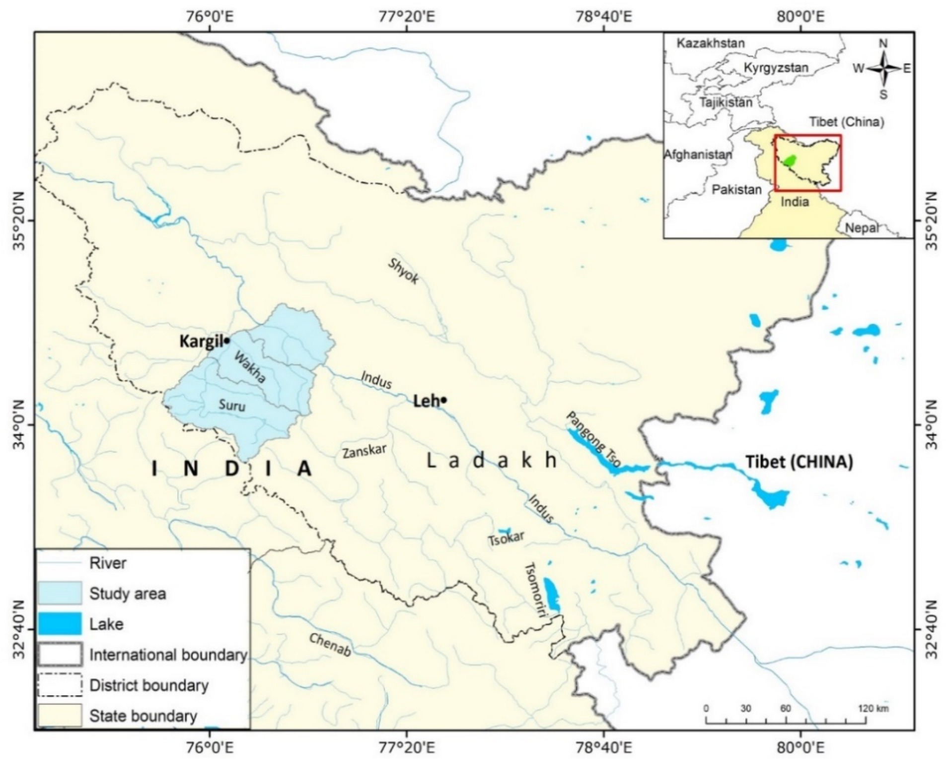
Figure 1. Location map of Suru, Wakha-chu and Lower Indus valley.
The priority ranking was developed based on the Conservation Priority Score (CPS) based on mode of harvesting (extractive pressure affecting populations), frequency of collection and diversity of uses following Mander et al. (1996) and Dzerefos and Witkowski (2001). The CPS was calculated for selected species based on four parameters, i.e., average density (within valley), extractive pressure affecting its regeneration (roots, flowers), the frequency of harvesting and the diversity of uses (Table 1).
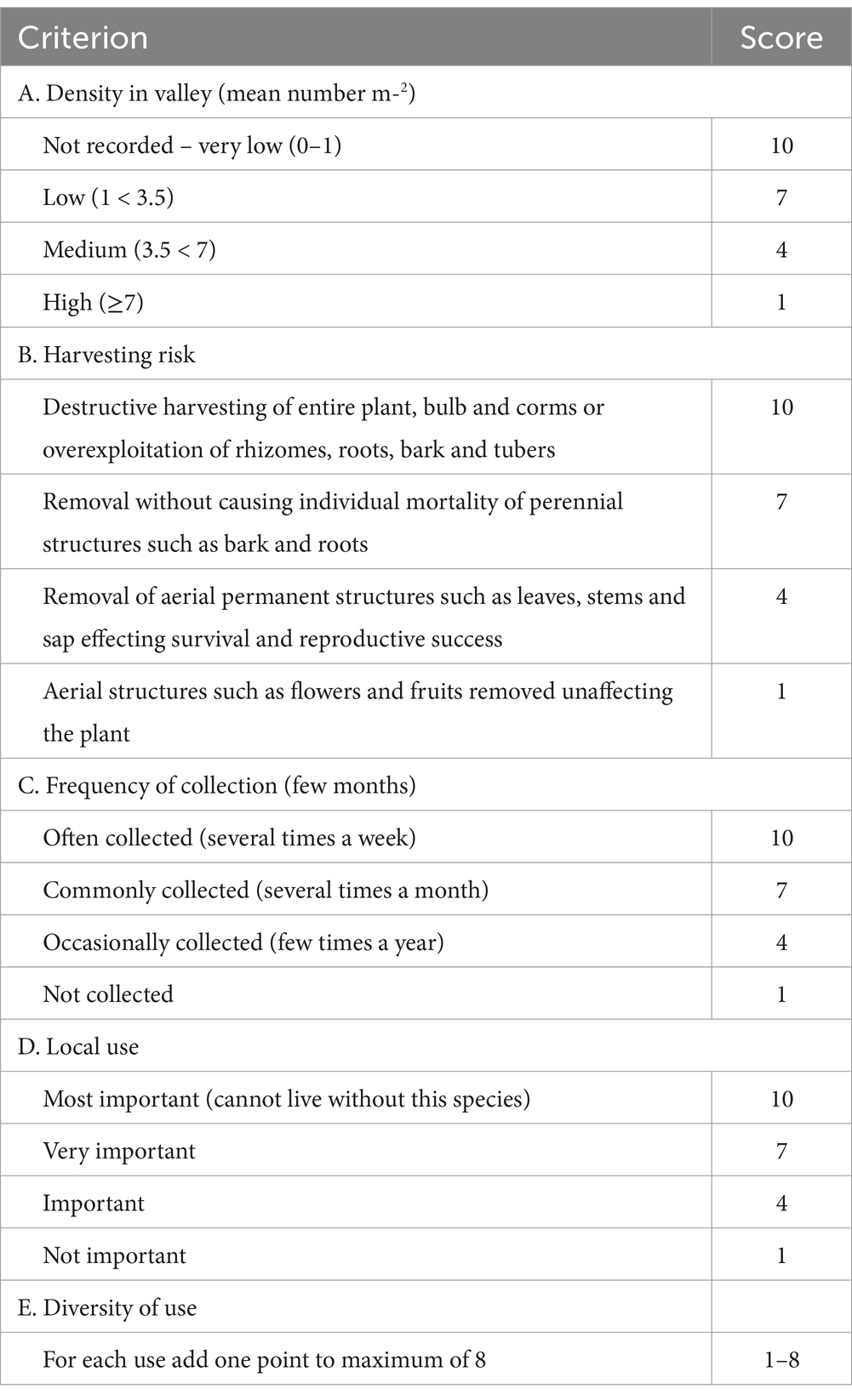
Table 1. Scoring criteria used for medicinal plants relating to plant density, harvesting risk, local importance and diversity of use (Dzerefos and Witkowski, 2001; Mander et al., 1996).
Conservation score was used to categorize the species according to their management needs which are as follows:
• Category I (CPS > 100) — Species that require immediate and strict conservation action and further study.
• Category II (CPS = 90–100) — These species also require conservation action on account of their very low density and can be harvested in limited quantity.
• Category III (CPS < 90) — These species have high potential of harvesting but may require some management initiatives to set up harvesting zones.
Information on the extractive pressure leading to depauperating of local populations and diversity of uses was collected using questionnaire surveys. The harvesting risk was assigned according to the plant part collected and its impact on regeneration. The diversity of uses of each species has been taken from Angmo et al. (2024). The frequency of collection has three broad categories, i.e., frequent (> 3 times a year), occasional (2–3 times a year) and annual collection (once a year).
Resource maps of the three valleys were prepared with the help of village head, healers and other participants in order to understand how the local residents viewed the present landscape. Participant rural appraisal (PRA) was done and the participants were explained the procedure and shown examples of resource maps from other studies (Kalibo and Medley, 2007; Nemarundwe and Richards, 2012). Firstly, a preliminary map with major landscape features (river, mountains) was prepared and later, the distribution of different plant resource was added with the help of herbal healers. Participants were provided A4 sized sheets of paper, pencils, erasers, and sharpeners. They were asked to show where they obtained their resources (fodder, fuel-wood, food, medicinal, ornamental, religious, dye and other) and also the protected areas by the village groups, which had been under strict rules. They provided descriptive captions that characterized features on the landscape and identified some opportunities and constraints for resource conservation.
Habitat suitability maps of priority species were prepared using habitat suitability (deductive) model in GIS domain. Five variables, i.e., slope, aspect, elevation, soil and land use/cover, were used to predict the potential habitat of species. The first three variables were derived from Aster Global Digital Elevation Model (AGDEM) which is available at 30 m resolution. Soil data were taken from Harmonized World Soil Database (FAO/IIASA/ISRIC/ISS-CAS/JRC, 2012). Since, the soil data are available at 1 km resolution, resampling was done at 30 m resolution before using it as input for the model. Land use/cover map was prepared from Landsat TM image of August 2009. Six major classes’ viz., plantation, agriculture, scrub, meadow, glacier and very sparse vegetation or bare ground, were derived using unsupervised classification. These classes were interpreted based on the field data collected during the survey work. Only three bands (2, 3 and 4) were used to perform classification. All the above-mentioned operations were carried out in ERDAS Imagine 9.3 software.
DEM derived variables were first categorized into discrete classes at equal interval and then each class was assigned a value from one of the four rating classes (0, 1, 2, 3) based on the proportion of its area falling within the 60 m buffer of presence locations. Consideration of buffer area is based on assumption that surrounding environment of presence location is more important compared to the microhabitat condition itself for large scale distribution mapping. Soil and land use/cover classes were also assigned ranks in the similar way. Derivation and ranking of elevation classes are based on mean value obtained within the buffer area. Finally, all the five layers were added together and the resultant map was classified in four suitability classes, i.e., unsuitable (1–9), least suitable (10–11), moderately suitable (12–13) and highly suitable (14–15), as shown (Figure 2).
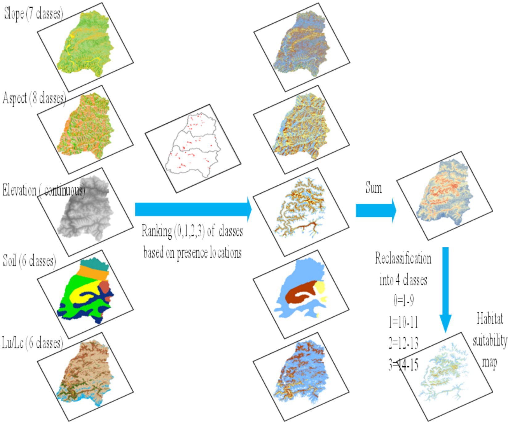
Figure 2. Schematic representation of processing Habitat suitability maps.
Performance of the suitability model was evaluated using Boyce index (Hirzel et al., 2006) which is a ratio between observed proportion (number of presence in a class/total presence location) and expected proportion (suitability class area/total area). Index was calculated for four suitability class and was plotted as graph. A large graph area above the value 1 indicates higher probability of finding a species in its suitable habitat than merely by chance. Half of the presence location of species was used to develop the model and remaining was used to calculate Boyce index.
Of all the 84 species of medicinal plants ranked using CPS scores, 33 species fall under the category I (high priority) and 51 in category II. Among 33 high priority (category I) species 19 was found in Lower Indus valley, 18 in the Suru valley and 16 in the Wakha-chu Valley (Table 2). Although, some of these species were previously listed threatened under various threat categories as per IUCN criteria (Nayar and Sastry, 1987; IUCN, 2001; Ved and Tandon, 1998), they do not fall under high priority in the present study area due to their moderate density and high frequency of occurrence. These species are Delphinium cashmerianum Meconopsis aculeata, Rhodiola heterodonta, Aconitum violaceum, Lancea tibetica, Lloydia serotina, Physochlaina praealta, Bergenia stracheyi, Podophyllum hexandrum, Clematis orientalis and Plantago himalaica. These species are collected less frequently but have a high diversity of use and harvesting risk (removal of entire plant) in comparison to other species. Unlike the studies by Kala (2005) and Tali et al. (2019) which prioritized the Himalayan medicinal plants based on the ethnobotanical importance and endemism, we used population status (availability), extractive pressures and diversity of uses for their conservation prioritization. This approach resonates with Mbelebele et al. (2024), which recommended prioritization of species based on the traditional ecological knowledge inherited by the local communities.
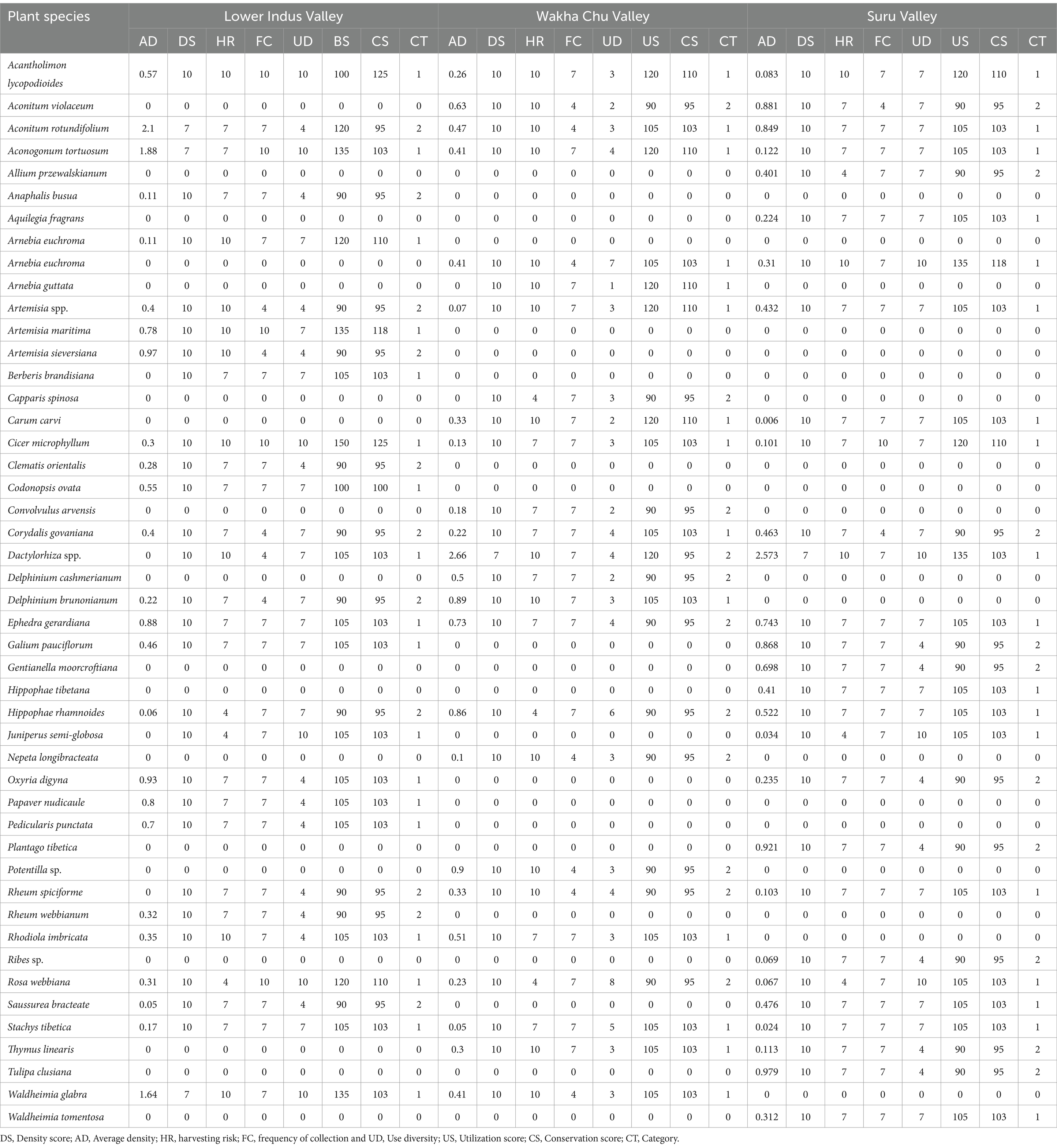
Table 2. Species of high conservation priority in Lower Indus valley, Wakha Chu and Suru Valley.
The following six species of high conservation priority were widely but sparsely distributed in all three valleys, viz., valley Acantholimon lycopodioides, Cicer microphyllum, Arnebia euchroma Stachys tibetica Dactylorhiza hatagirea and Aconogonum tortuosum. Carum carvi, Aconitum rotundifolium and Artemisia santolinifolia were present only in Suru and Wakha chu valleys. Juniperus semi-globosa, Rosa webbiana, and Ephedra gerardiana were present in Lower Indus and Suru valleys. Waldheimia glabra Rhodiola imbricata were present in Lower Indus and Wakha-chu Valleys. Further, in Lower Indus Valley two species Berberis brandisiana Dactylorhiza hatagirea were ranked among the most vulnerable species based on their absence in the quadrats and intensity of use. In Wakha-chu Valley, Arnebia guttata was the only species, which was not present in the quadrat sampling.
The study reveals that all the three valleys have different assemblages of medicinal plants. Corydalis govaniana was common only between Lower Indus and Suru valleys. Rheum webbianum was not recorded in any of the sampling plots and only few individuals were recorded from Lower Indus valley.
According to most of the informers, the local traders have been increasingly exploiting many species for commercial purpose in recent years that is the cause of serious concern valley.
Resource maps created by local communities reveal a diverse landscape with both manmade and natural features, including grazing lands in the mountains, shrubland in the lowlands, farms, settlements, roads, rivers, and rivulets. The maps also show plant resource collection sites and protected areas (Figure 3). The resource maps generated in this study are similar to those of Stosch et al. (2022) who used participatory mapping in catchments to identify areas of conflict and diverse stakeholder perceptions and broader land-use categories. This study also reveals that the place names often reflect unique habitats or geographical features, leading to similar names in different valleys, such as “Sari-chen,” where Sari (Cicer microphyllum) is collected, and “Lachu-tse,” known for Lachu (Rheum spiciforme and R. tibeticum).

Figure 3. Map drawn through participatory rural appaisal (PRA) by the participants of Suru valley (Top), Lower Indus valley (Middle) and Wakha-chu valley (Bottom) to indicate presence of natural resources and their collection sites.
In Lower Indus Valley the pasturelands in villages Chullichan village: (Wachara, Serchey brok, Mushbar), Shertsey(Mushbar, Serchey brok), Batalic (Serchey Brok, Gar-gar lungba, Lahlung dok), GarGardoh(Gargardoh lungba), Hurdas (Hurdas Lungba) Darchik (Shashi thang, Manta and Langtot), Beema (Lastiang dok, Sanit dok, Nirda, Yaldoh dok, Baldez lungba, Phildor lungba), Dha (Yaldor lungba, Nirda, Dha lungba), Garkon (Garkon lungba, Bararu, Yaldor, Nirda, Dah Lungba), Sanatse (Langtot, Manta), Hanugogma (Spangkhang, Dwazam, Chopodok, Phatalungba), Hanu yokma (Atakur, Chopodok, Khas-khas lungba Tsemomor, Stakpa lungba, Silmor, Spangkhang, Bila-gu), Hanu thang (Chopodok). In Wakha Chu valley Minji (Lamathang, Lunpo-zang, Thalichen) Baru (Baru-Rong), Paskum (Nangmikkok, Shakulekchey, Kapiloo, Kurbathang, Farki haltab), Lotsum (Lungbar, Kasbuchan, Stothang sandar), Darket (Darket Lungba, Skangbu, Ri-si thang, Bill billthang), Shargole (Dip, Sarichen), Karamba (Chumik - gu, Tsos- Tiang, Daser, Samer, Ralambapa, Thang bu), Khatsey (Tyan-doh, Apodong, Nei-ngos, Ka-chok, Tai-chu, Lora, Skimthang, Spangthang, Chaba-brok, Tapir), Phokar-Phu (Sapila, Chumi-gu, Gangma-go, Samikchan and yukpol), Mulbek (Mulbek rong, Kumber, Brak-kar, Tser-zey, Byang-sa, Mas-pus, khansar, Chomolung, Lungnis), Wakha (Kum-bar, Namikila, Lambar thang, Wakha Rong).
In Suru Valley in Tashi tongzey village (Rong, Stagabsa, Khosokla, Sheletokpo, Penzila, Doks), Yul-Doh (Stagabsa, Rong, Shapat nalla), Pharkachik (Phrka Ri, Shapat nalla), Tongol (Chubar, Thanak, Amaltik), Achambur and Kochik (Rong), Choskar (Pranti or Chokor lungba), Panikar (Chilling nala), Thulus Pursa (Nam-suru nalla), Kargee and Taisuru (Chilling nala), Namsuru (Chrkat nalla), Kwas (Zaltak,kunchung,gakschung,chu-ink, chudoktse spang, brok, Dambu, Brakmar), Yuljuk (Shangshing nalla), Putikchey (Spanglung, sailung, Kapaling, Naksbur shishing, sari Nagma, Shadmarigmo), Gailing (Phu), Sangra (Nakpo-sbrok), Karpokhar (Har-kor nalla, Stak-sok, Burtse thang, Diks, Lunrtse-thang), Thang-dumbur (Rongdumbur), Nakma, Kusar(Nakpo-chuRi, Ri nakpo), Karchey Khar (Ser-Ser mo, Sari-Brok, Gana brok, Yokma- gato khar, Che lasa), Thasgam-thuina-(Ri), Barsoo (Brokchong, Choo-brok, Nizar, Biangszgam, Dambutse), Thila (Thila Brok), Khandi(Khandi brok, Tik-Tik lungba, jongkhangsa, Zgangbar lungba), Shargandi (Rongtse), Ichhu(Icchu Lungba, wakha la), Pangbar (Chargot la, Rusi la), Lankerchey (Mesarsok,Dambutsrwa, Ritwrstwa, Sumdoh nalla, Shakring), Phurana (Laser, Gongpodoks, Brokchung, Kamburat), Selaskot(Spang, langma), Gon Mamgalpur (Rigabsa), Trespone (Sarichen la, Brok-chung, Dips), Kanor (Sapi nalla), Trambis (Saichen, Sharul), Sapi (John, brakar), Minji (Lamathang, Lunpo-zang, Thalichen), Baru (Baru-rong), Stakpa (Stakpa rirong).
Livestock husbandry has been one of the primary sources of livelihood for locals besides agricultural activities. The unique topography consists of distinct valleys and pasturelands that are integral to the region’s ecology and communities. Each village has designated summer and winter pastures for local use, essential for sustaining livestock, a primary livelihood for many. Most of the pastoral and agro-pastoral activities were traditionally performed on a cooperative basis by sharing the human resources on mutually agreed terms. Exchange of various services were integral part of equitable sharing of benefits arising from the pastoral and agro-pastoral practices locally termed as Tonglen/ Melak for agricultural related activities, Rarez and Barez (livestock and cattle rearing). In the Lower Indus Valley, rotational grazing is practiced to mitigate overgrazing. Hanu-yokma and Hanu gongma has privately owned summer pastures, reflecting diverse land ownership patterns. Chopodok, once the largest grazing land for the herders are now deteriorated due to army settlements, affecting its utility. Starkpuchan Lake, the largest and most culturally significant lake in the region, connects to Dha-Lungba, the second-largest grazing area in LIV. However, feral dogs in Chopodok pose a significant threat, killing up to 8–10% of livestock annually. In Wakha-chu Valley, residents practice both migratory and semi-migratory grazing. The valley is known for its larger livestock populations, faces a decline due to fodder shortages. Only Kanji village continues traditional migratory grazing, but even there, elders reported declining plant species in grazing sites like Rong and Lachu-tse. In Suru Valley, semi-migratory livestock practices dominate, except in Rangdum, where conditions are less amenable. Farmers commonly hire Gujars, (professional grazers) to lead livestock to sub-alpine and alpine pastures during summer (June–August), returning in autumn. This traditional practice supports the region’s agricultural cycle by integrating professional knowledge and seasonal movement.
The resource maps show different landform units based on their usage. Fuel wood and fodder are collected from the same pastureland used for grazing. The maps highlight fuel wood sources based on habitats, such as Juniperus polycarpous in high scrublands and Hippophae rhamnoides, Salix spp., and Myricaria elegans in riverine areas. Large quantities of fuel wood, about 60-100 kg per household monthly, are collected during the summer. The most commonly gathered fodder plants are Cicer microphyllum and Aconogonum tortuosum. Kanji, Sapi, Sangra, and Rangdum in Suru valley are key areas for medicinal plant collection. While local rules exist, with a fee of INR 60–100, there’s no restriction on the quantity of medicinal plants that can be collected. Figure 4. Shows the various kind of anthropogenic pressure in Western Ladakh.
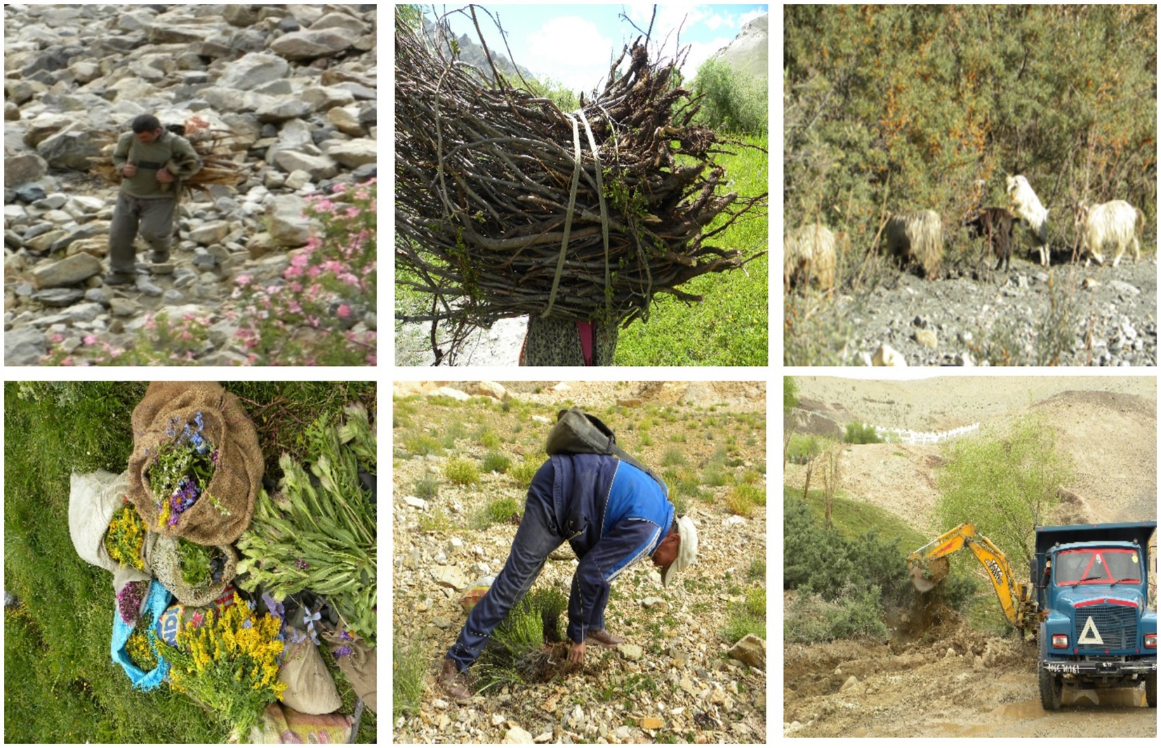
Figure 4. Various kind of anthropogenic pressure in Western Ladakh.
In Western Ladakh, officially, there are four protected areas notified as wildlife reserves (Randum, Brako and Kanji) and game reserves (Bodh Karbu). Other than that, in Lower Indus valley there are two locally protected areas managed by the local women group for 10 years on rotational basis. These areas are Ruray and Bunos Bar where collection of Junipers and any other plants were prohibited by the local communities. Other than these two protected areas, a few small areas are also protected because of their religious significance. These areas are marked pagoda by Juniper stem and a satin scarf placed on the hilltop with or without animal horns.
Protected area in Wakha-chu Valley includes Wakha-rong in Wakha village, Mulbek-rong in Mulbek, Phololing-chen, Gongma spangbu and yokma spangbu in Darket village are the community-protected valleys, which are partially restricted for 3–4 years from collection. Other than these, one sacred groove, Chomo shukpa, in Western Ladakh, in Phokar-Phu and consists of strictly protected stand of Junipers, supposed to be the abode for their deity. They believe that any destruction in the patch will leads to something bad not only to the individual person but also to the whole village. The people in this valley is strong believer of this deity (Shaman) (Angmo et al., 2022).
Category I includes species not found during the sampling in the Lower Indus valley but are listed as key species from the same valley, which is Dactylorhiza kafiriana and Berberis brandisiana (Adhikari et al., 2013). All the species in category I and category II have very low densities. However, conservation score was based on the utilization risk also.
Species categorized under high conservation priority have limited harvesting potential and they needed immediate attention from the healers, locals as well as conservation agencies. Species with limited use and medium conservation priority can be allowed to harvest after deciding their harvesting potential based on scientific guidelines. Species, kept under medium or low conservation priority (Table 2), can be harvested to meet the current local requirements but must be monitored regularly to ensure their healthy population size.
Harvesting potential of species depends on regeneration capacity of species, life form of plants (annual or perennial), and various other factors. Several species, e.g., Dactylorhiza hatagirea, D. kafiriana, Aconitum rotundifolium, Aconitum heterophyllum and Aconitum violaceum perennate through tubers and seeds. They can withstand exploitation if not harvested for tuber. But these species are harvested for tubers by the healers and upper stem by the locals for fodder. Harvesting after flowering and fruiting is suggested to increase both the yield and the quality of resources while this practice also ensures natural regeneration (Dzerefos and Witkowski, 2001). Perennial species such as Aster flaccidus, and Saussurea gnaphalodes face relatively less harvesting risk. The species such as Aconitum heterophyllum and Aconitum violaceum are threatened and do not need any specific conservation measure, but leaving at least one area (habitat) intact will ensure their continuous availability in future. Though livestock grazing per se does not affect the populations of medicinal plants (most of them being unpalatable), excessive grazing can lead to soil erosion and habitat degradation (Thapa and Chapman, 2010). It is noteworthy that more than 40,000 cattle and 50,000 sheep and goats use the pastures of western Ladakh every year and creates immense pressure on the plant resource available in the area. Obnoxious species such as Rumex nepalensis and Polygonum paronychioides grow in abundance on places where grazing intensity is high and these plants create hindrance in the growth of several dwarf medicinal herbs. Grazing pressure is low in Lower Indus valley as compared to other two valleys.
Providing alternatives to fuel wood and fodder species along with the cultivation of commercially important species may be helpful in conservation planning. There is immense potential to grow some wild species in home gardens in Western Ladakh. Efforts to cultivate some medicinally important species have not been fully successful in this region and more research and development is required.
Category III species such as Delphinium cashmerianum was found at high densities and is widely distributed across Suru valley, but is scarcely found in Lower Indus valley. Aconitum violaceum was found in Suru valley in field margin habitat with high density. Tulipa stellata are widely distributed across Suru valley but has low densities in Wakha-chu valley and was absent in Lower Indus valley. Average densities of harvestable species range from 12.6 individual’s m-2 to 0.01 individuals m-2 while non-harvestable species range from 0.8 individuals m-2 to 0.02 individuals m-2. The proposed harvesting zone in the Suru valley has high density of several harvestable species.
Habitat suitability map of 15 species out of 16 species predicted reasonable results as more species presence location was found in suitable habitats than unsuitable habitats, however in case of Dactylorhiza spp. (Dactylorhiza kafiriana and Dactylorhiza hatagirea) and Rhodiola sp. the performance of model was poor (Figure 5). Boyce index performs reasonable for species which are not very specific to a particular habitat (Hirzel et al., 2006), but it does not imply to Dactylorrhiza which was found growing in more diverse habitats than Rhodiola. Other possible reason of poor performance of model could be a lack of randomness in presence locations. Boyce index is shown in Figure 5 for habitat suitability map of different species. Number of species needing conservation assistance for survival is increasing day by day due to their reduced extent of distribution as a result of either change in environmental factors associated with their habitat or overexploitation by human beings. Human and financial resource available for conservation activities are limited and hence careful selection of approaches for conservation is necessary. In comparison to methods that require extensive data and are more time and resource consuming, the current method provides a fast and reliable approach to identify action priorities in geographical space with lesser information on species occurrence.
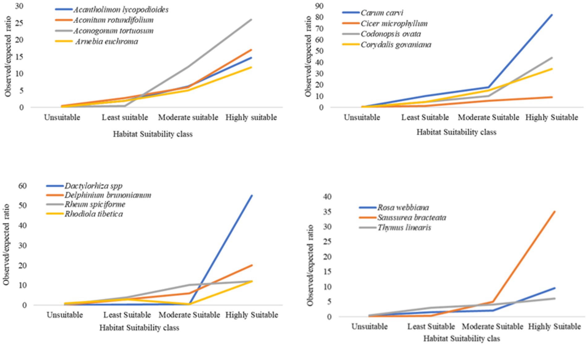
Figure 5. Boyce index for the habitat suitability map of different species.
Total geographic area covered under highly and moderately suitable class of different species suggests that 3 (Carum carvi, Codonopsis ovata, and Rheum moorcroftianum) out of 16 species have narrow geographic range (1–3% of total area) while 3 species (Rheum tibeticum, Rhodiola tibetica, and Arnebia euchroma) have wide range of distribution (10–16% of total area) Table 3.
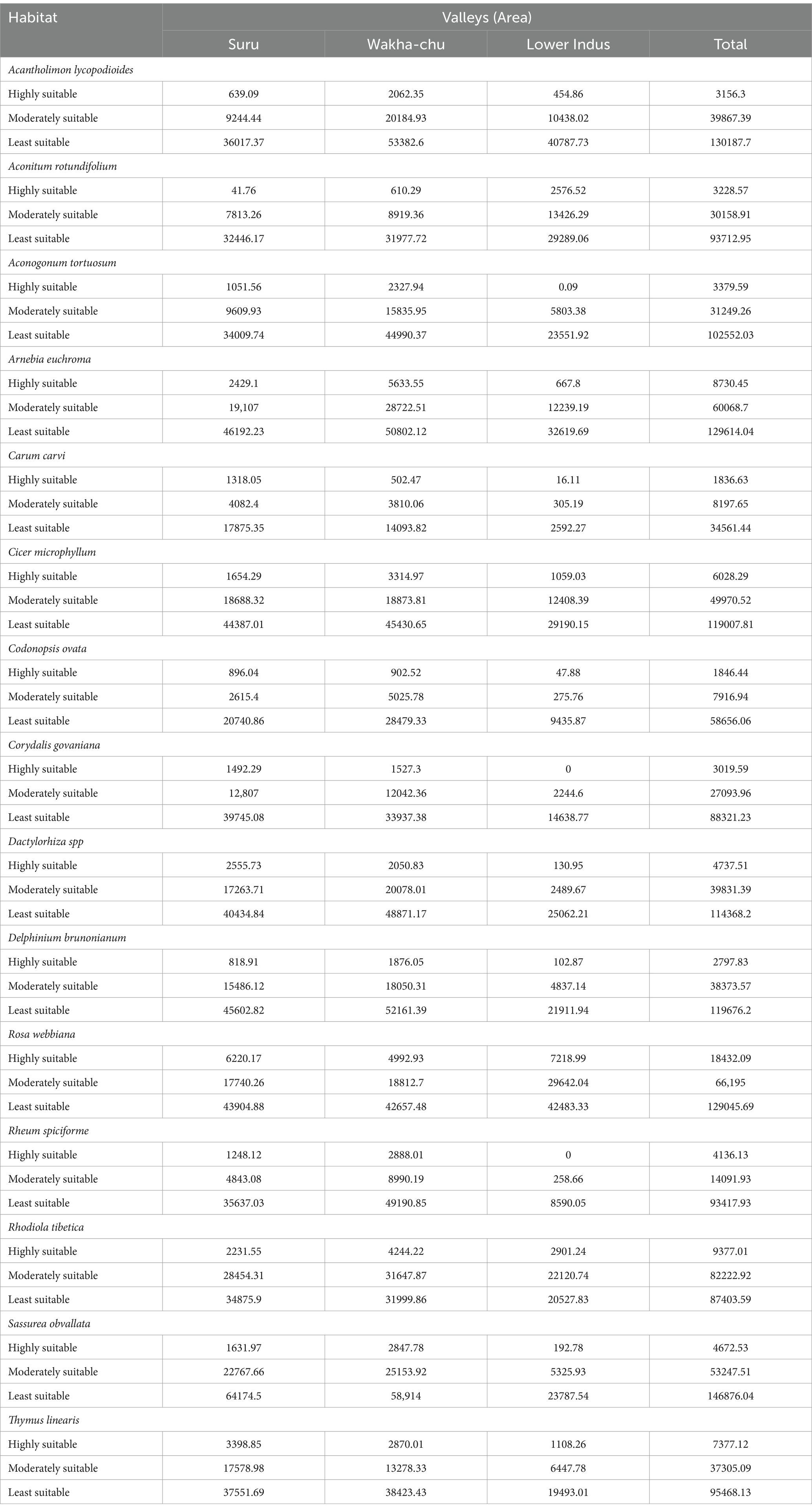
Table 3. Habitat suitability classes (area in hectare) of various species in the study area.
Orientation of mountain in different valleys greatly affect the proportion of aspect classes and hence the distribution of species as shown in many of studies where slope affects forest dynamics and the spatial pattern of trees (Baldeck et al., 2013; Ferry et al., 2010; Robert and Moravie, 2003). The most important topographic factors, slope aspect affects vegetation patterns and distribution by changing the micro-habitat (Åström et al., 2007). Different slope aspects determine the composition, species distribution, and ecosystem processes of plant communities due to variations in natural illumination, moisture, temperature, and soil (Bennie et al., 2008, Carletti et al., 2009; Gong et al., 2008, Landolt et al., 2010; Zhang et al., 2022). Wakha-chu and Lower Indus valleys have almost similar orientation with dominating North-East and South-West aspect while Suru valley has more East and North-West aspect. Most of the species are distributed on North and North-West aspect. Species, which has considerable area of its habitat on South-West aspect, includes Aconitum rotundifolium, Aconogonum tortuosum, Codonopsis clematidea, Dactylorhiza spp. and Rheum sp. The most preferred slope class for most of the species is 20–30° followed by 10–20° while, species such as Dactylorhiza hatagirea, Carum carvi, and Codonopsis ovata species preferred less than 10° slope. Species which were found on slopes steeper than 30° include Rheum moorcroftianum, Saussurea bracteata and Rhodiola tibetica. The areas with steeper slopes (20–40°) are present more in Suru valley, hence it consists more suitable habitat in comparison to other two valleys.
Elevation was considered as proxy for several environmental factors, most importantly temperature, hence it represents environmental limit that constitutes species habitat. Suitable habitats of most of the species are distributed within the elevation range of 3,500-4500 m. Species which are distributed at higher elevation (>4,000 m) includes Saussurea bracteata, Corydalis govaniana, Gentiana transalaica and Rheum moorcroftianum. While Carum carvi, Codonopsis ovata and Dactylorhiza spp. are distributed at comparatively lower elevation (<4,000 m). Areas above 4,500 m elevation are mainly present in Suru valley.
Composition of soil is different in three valleys which caused considerable spatial variation in the distribution of species across valleys. Cambisol of Suru valley is most suitable soil for 10 out of 16 species followed by Leptosol, which was preferred, by four species. Aconitum rotundifolium, Saussurea bracteata, Rhodiola tibetica and Delphinium brunonianum were also found on Acrisol soil which is mainly composed of rock. While number of presence location could have affected the class representation, it can be assumed that species has more chance to be encountered in most suitable habitat.
Land use/cover of an area represents both differences between natural and human dominated landscape as well as variation within each type. Three classes that were found associated with most of the species are alpine meadow, alpine scrub and areas with sparse vegetation. Presence of species in later class indicates their adaptation to more harsh condition than those species found in other two classes. 12 out 16 species occurred mainly in alpine meadow class. Codonopsis ovata and Dactylorhiza sp. has most of its suitable habitat under alpine scrub class while Acantholimon lycopodioides, Arnebia euchroma and Rheum moorcroftianum were found equally associated with alpine meadow and very sparse vegetated surface class. Carum carvi and Codonopsis ovata were distributed around agricultural field indicating that human intervention could have added to its regeneration status. Suitable range of temperature and availability of soil moisture are probably the most important factor for plant growth in high altitudes. The accuracy of present distribution map can be improved by incorporating these variables in the model. However, one can assume that all the three valleys fall within same climatic zone and hence there is no spatial variation due to climate. Some species show adaptation to a wide range of climatic condition such as Delphinium brunonianum was found from 3,200 to 4,600 m elevation range while Corydalis govaniana were found within a narrow range (3,900-4,600 m) of geographic and climatic parameters. Habitat suitability map (Figure 6) generated with the help of geographical variables provide a broad idea regarding the possible extent of species habitat. Despite several limitation of the adapted method, it has been used successfully to make a preliminary estimation of extent of occurrence of species. However, a further refinement in the mapped distribution is necessary to improve its accuracy, which can be done through verifying areas depicted in the map. The rapid loss of biodiversity worldwide, mainly due to anthropogenic activity, has led to the need to search areas of high conservation importance (Kati et al., 2004; García, 2006). However, identification of such areas is not enough and further assessment of different aspects such as the requirement of rapidly growing human population is also necessary (Cincotta et al., 2000). Human activities in all the three valleys are increasing day by day due to tourism and developmental activities, which need to be managed to add conservation efforts. Figure 7 shows the selected species and their habits in western Ladakh.
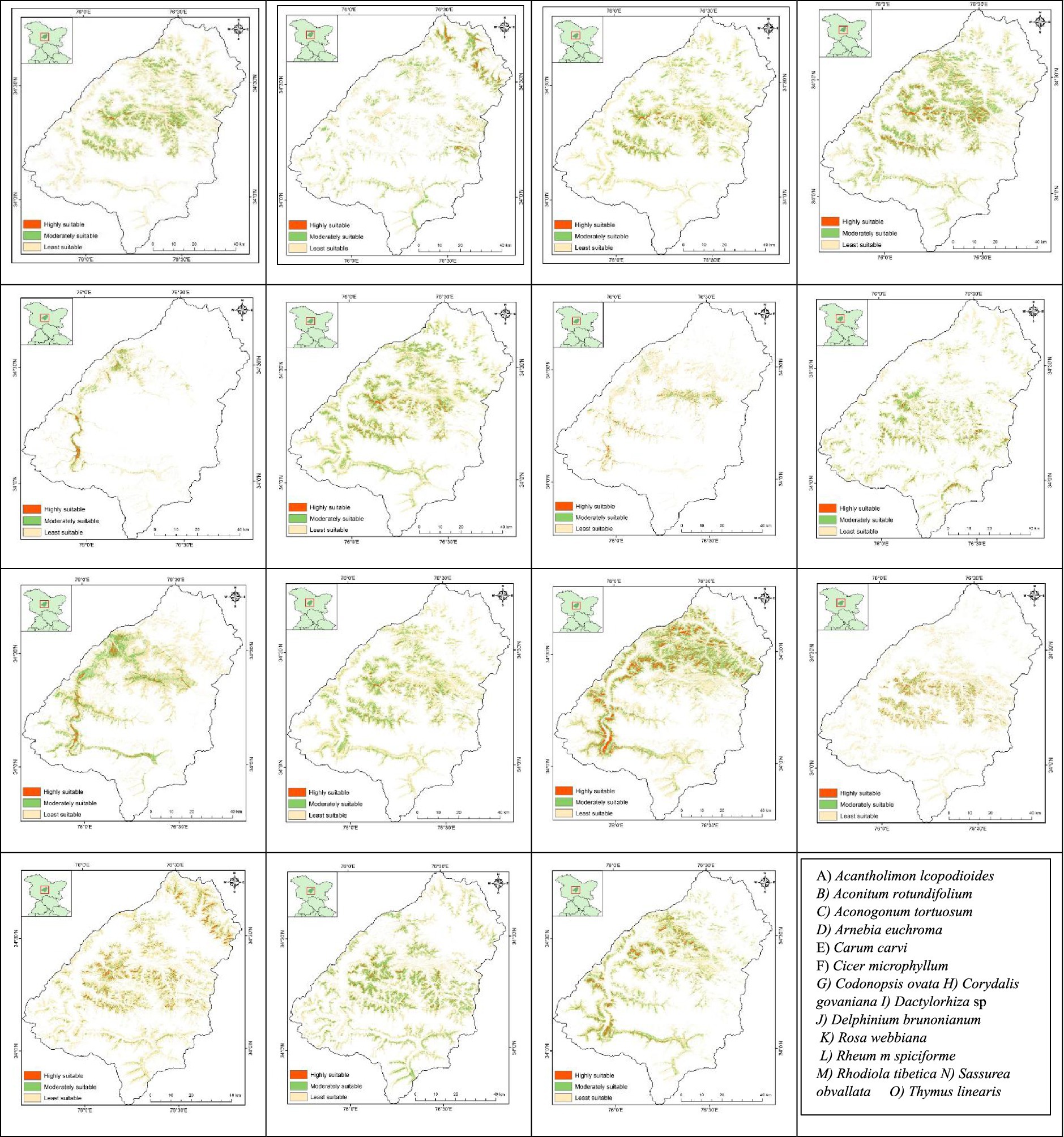
Figure 6. Habitat suitability map of different species.
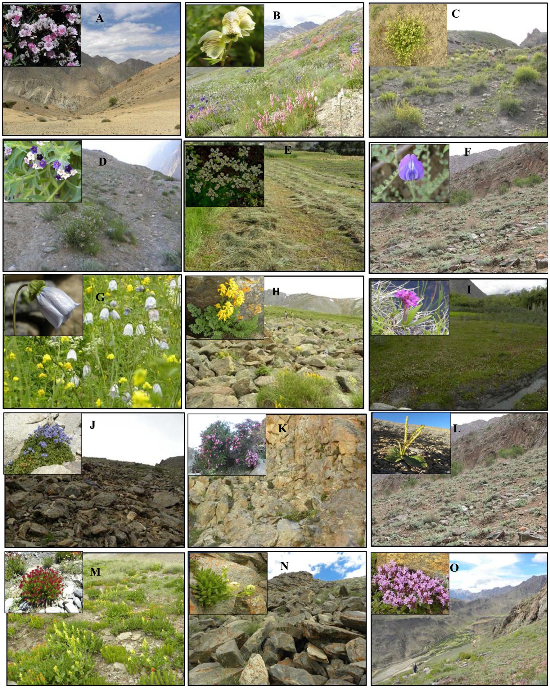
Figure 7. The Species and their habitat. (A) Acantholimon lcopodioides (B) Aconitum rotundifolium (C) Aconogonum tortuosum (D) Arnebia euchroma (E) Carum carvi (F) Cicer microphyllum (G) Codonopsis ovata (H) Corydalis govaniana (I) Dactylorhiza sp (J) Delphinium brunonianum (K) Rosa webbiana (L) Rheum spiciforme (M) Rhodiola tibetica (N) Sassurea obvallata (O) Thymus linearis.
Their description of Class rank of variables for different species habitat mapping is given in Tables 4–6.
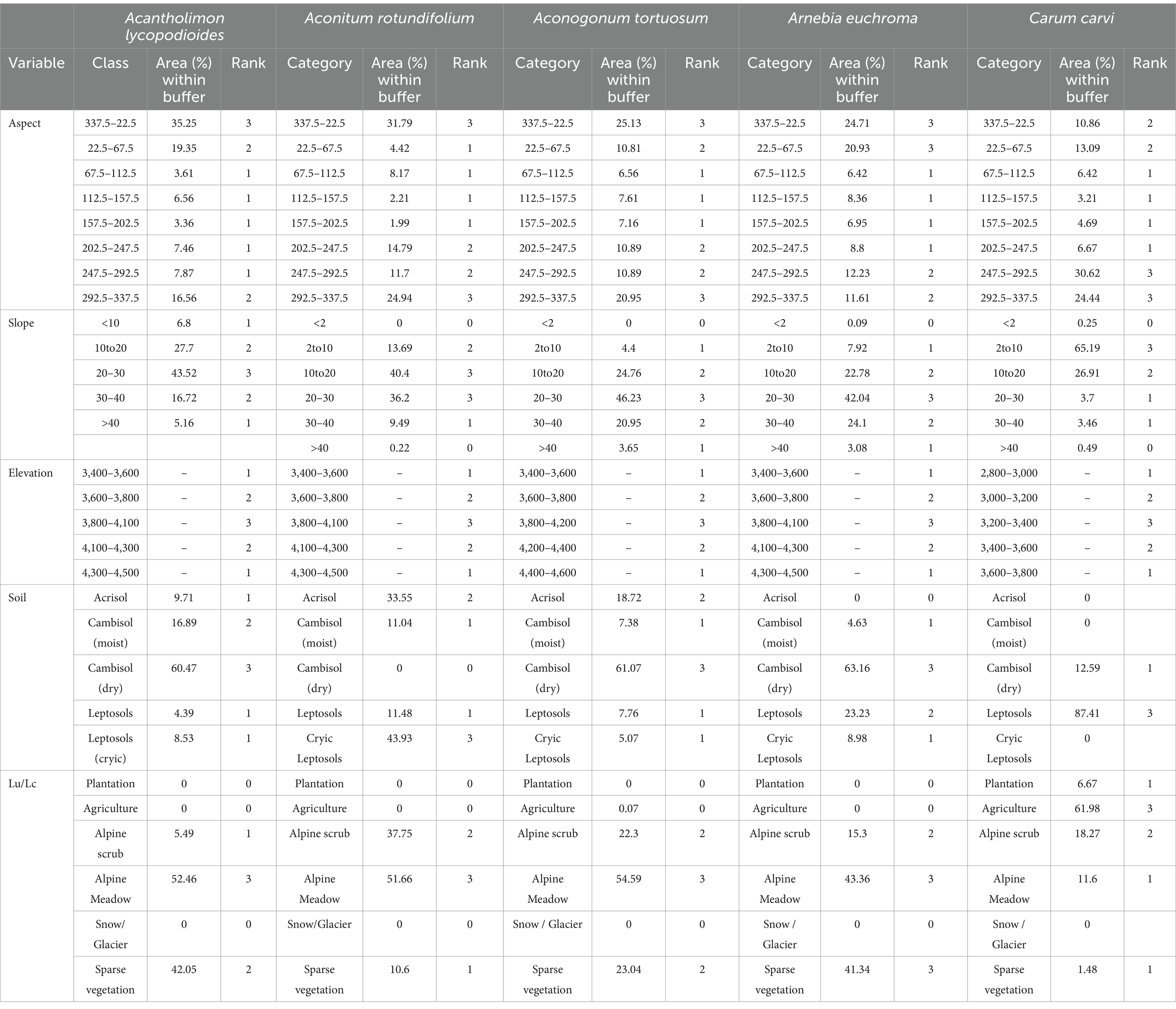
Table 4. Class rank of variables for different species habitat mapping.
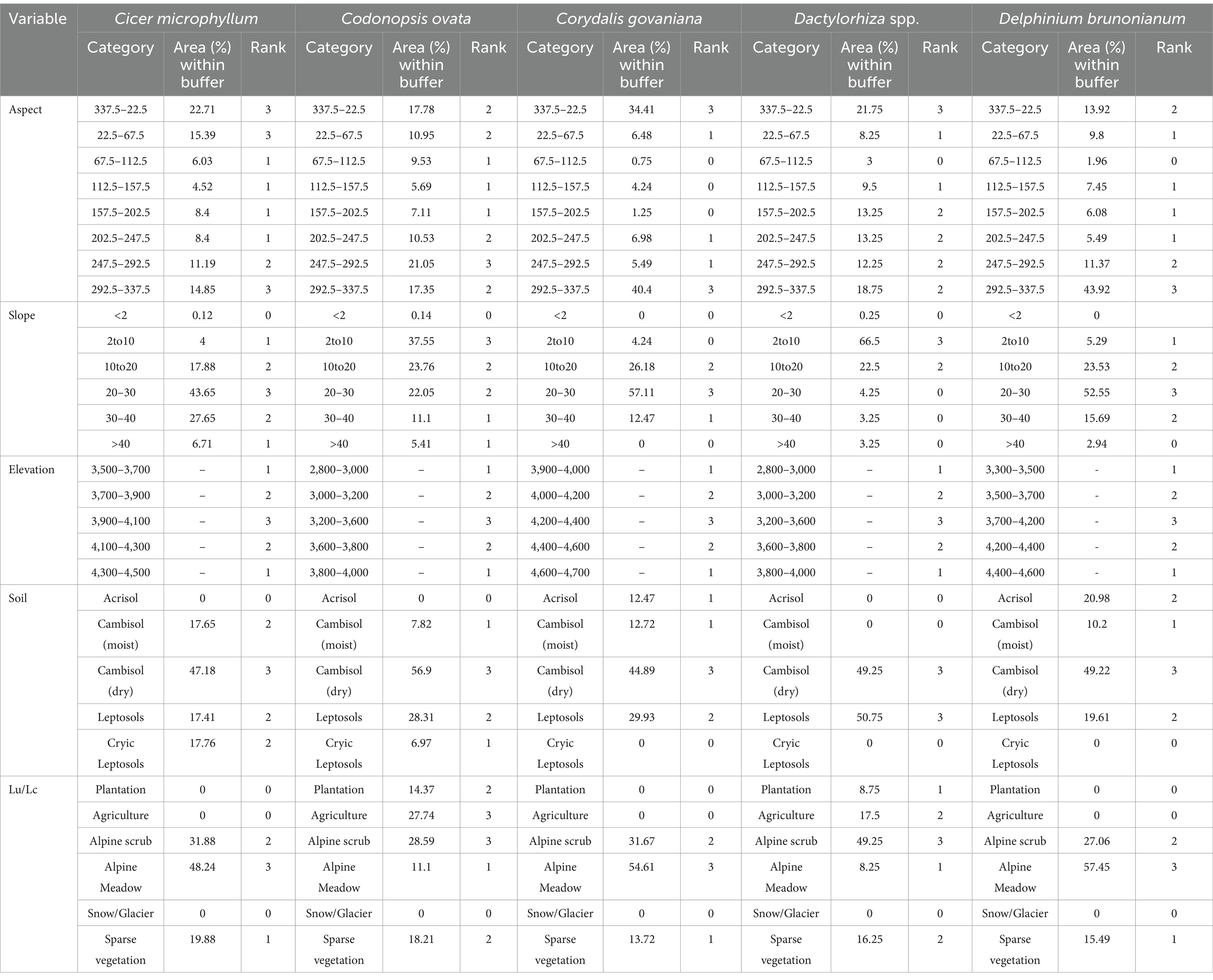
Table 5. Class rank of variables for different species habitat mapping.
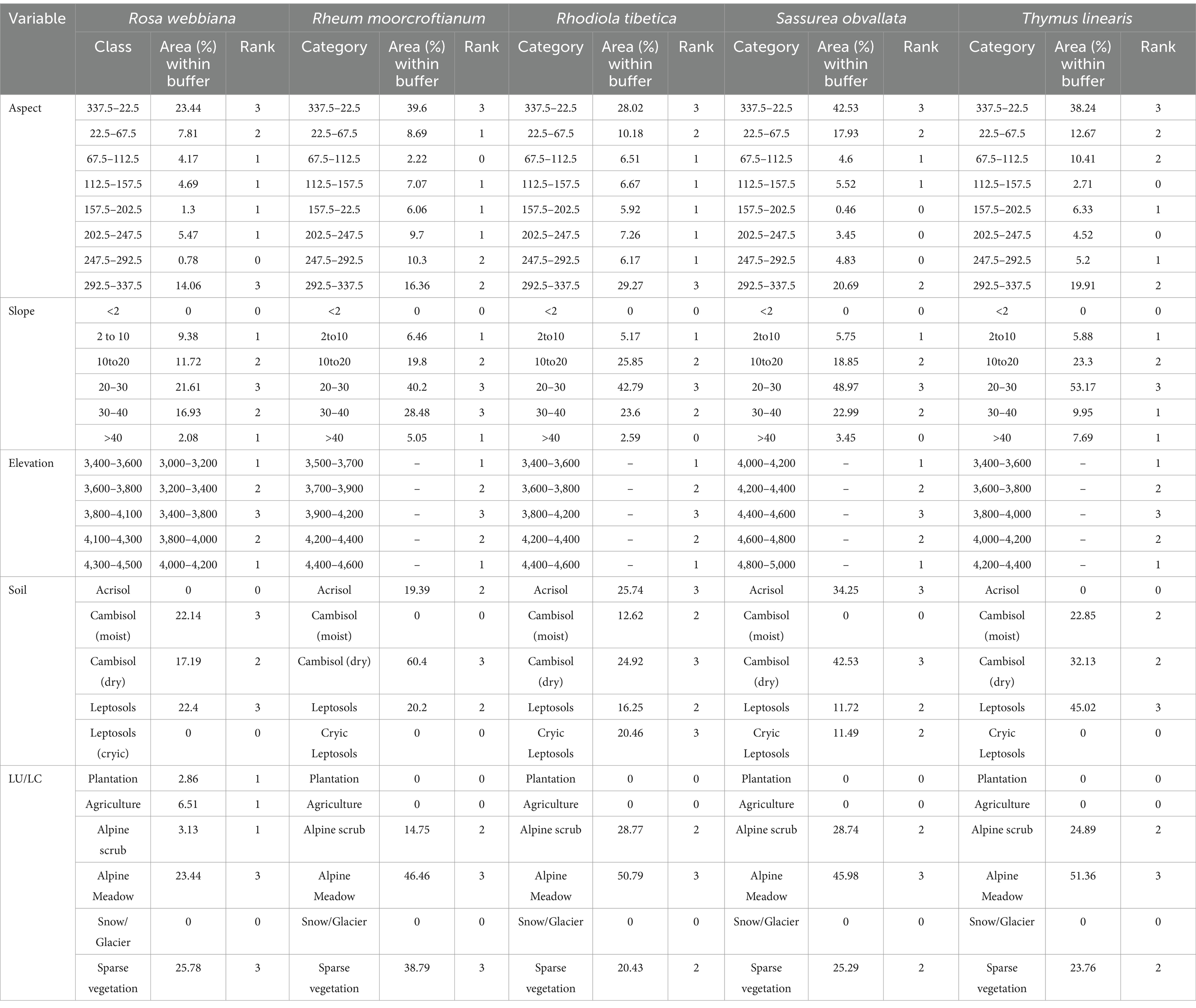
Table 6. Class rank of variables for different species habitat mapping.
The detailed description of species on habitat preference and its density in various land form units is as follows:
Acantholimon lycopodioides is commonly known as Longzey and are valued as one of the most important plants among the locals as firewood and fodder species. The species is distributed in all the three valleys. The presence of this species is mostly in the high elevations’ areas in stable and alpine meadows and may also occurs in cliff, stable slopes, at plateau table and scree slopes. The density (individuals m−2) of Acantholimon lycopodioides across different landform units in three valleys, Lower Indus valley (Alpine meadow 1.72 ± 0.69, Stable slope 2.28 ± 0.83, Bouldery 2.33 ± 0.39), in Wakha-chu valley (Moraine 0.87 ± 0.37, Stable slope 0.07 ± 0.07, Bouldery 2.33 ± 0.39) and in Suru valley (Alpine meadow 1.688 ± 0.71, Stable slope 0.01 ± 0.20).
Aconitum napellus var. rotundifolium is locally known as Boga and was encountered on the higher elevations in Western Ladakh mostly recorded above 3,800-4500 m, encountered in the high stable and alpine meadows in Suru valley, in stable and moranic slopes in Wakha-Chu valley and in boulder, stable and marsh meadows in Lower Indus valley. The plant appears in late June and flowers till early August–September. The density (individuals m−2) of the species across different landform units in Lower Indus valley (Alpine meadow 1.72 ± 0.69, Stable slope 2.28 ± 0.83, Bouldery 2.33 ± 0.3), in Wakha-chu valley (Moraine 0.87 ± 0.37, Stable slope 0.07 ± 0.07) and in Suru valley (Alpine meadow 1.688 ± 0.71, Stable slope 0.01 ± 0.20).
Aconogonum tortuosum is commonly known as Nyalo and are found along the elevation of 3,500-4,600 m in Stable and Moraine. It is used in fodder, religious, ornamental and medicine. The density (individuals m−2) of the species across different landform units in Lower Indus valley (Stable slope 1.49 ± 0.38, Moraine 2.26 ± 0.22), in Wakha-chu valley (Moraine 0.4 ± 0.18, Stable slope 0.79 ± 0.15, Scree 0.36 ± 0.16) and in Suru valley (Alpine meadow 0.10 ± 0.07, Plateau 0.15 ± 0.14, Rock and cliff 0.04 ± 0.07, Scree 0.12 ± 0.13, Stable slope 0.01 ± 0.20, Moraine 0.19 ± 0.13).
Arnebia euchroma is commonly known as Demok and are found along the elevation of 3,500-4600 m in stable, rock and cliff, moraine, scree and marshy meadows. It is used in food, fodder, fuelwood, ornamental, religious, dye, medicinal and other use categories. The density (individuals m−2) of the species across different landform units in Lower Indus valley (Rock and cliff 0.06 ± 0.08, Scree 0.15 ± 0.13), in Wakha-chu valley, (Stable slope 0.23 ± 0.08, Rock and cliff 0.58 ± 0.12, Moraine 0.4 ± 0.18, Scree 0.43 ± 0.19) and in Suru valley (Stable 0.002 ± 0.07, Rock and cliff 0.2 ± 0.12, Moraine 0.18 ± 0.07, Marsh meadow 0.85 ± 0.37).
Carum carvi is commonly known as Nyotse and are found along the elevation of 2,900-3,700 m in Field margins and Marsh meadow. It is used in food, fodder and medicinal categories. The density (individuals m−2) of the species across different landform units in Wakha-chu valley (Field margin 0.23 ± 0.15, Marsh meadow 0.42 ± 0.28) and in Suru valley (Field margin 1.47 ± 0.24, Marsh meadow 1.28 ± 0.54).
Cicer microphyllum is commonly known as Sari is one of the most important fodder species of Western Ladakh and had been extracted in bulk from the wild. It is used in Amchi system of medicine and also used locally by the people for curing ulcer in animals (Angmo et al., 2012). The pods and leaves are edible and eaten as local delicacy. It is distributed at an elevation of 3,500-4500 m. The density (individuals m−2) of the species across different landform units in Lower Indus valley (Bouldery 0.10 ± 0.07, Stable 0.13 ± 0.07 Scree 0.13 ± 0.08, Moraine 0.84 ± 0.12), in Wakha-chu valley (Stable slope 0.15 ± 0.35, Scree 0.17 ± 0.10, Field margin 0.06 ± 0.12) and in Suru valley (Bouldery 0.13 ± 0.10, Stable 0.002 ± 0.06, Rock and cliff 0.04 ± 0.06, Moraine 0.14 ± 0.06, Marsh meadow 0.17 ± 0.19).
Codonopsis ovata is commonly known as Lurdud dorjey and are found along the elevation of 2,700-4500 m. It is used in food, fodder, ornamental and medicine. The plant is mostly found in the fallow fields and field margins. The density (individuals m−2) of the species across different landform units in Lower Indusvalley (Bouldery 0.29 ± 0.35, Field margin 0.8 ± 0.25), in Wakha-chu valley (Alpine meadow 4.38 ± 2.69, Field margin 4.54 ± 0.67) and in Suru valley (Moraine 0.07 ± 0.08, Field margin 2.44 ± 0.52, Marsh meadow 1.27 ± 0.75).
Corydalis govaniana is commonly known as Makshang and is one of the frequently used herbs in Amchi system of medicine and also by the locals. The leaves are edible and are used as highly nutritious vegetable. The species found in high elevation varies from 3,500-4600 m. The density (individuals m−2) of the species across different landform units in Lower Indus valley (Bouldery 0.4 ± 0.19), in Wakha-chu valley (Stable slope 0.26 ± 0.10, Bouldery 0.25 ± 0.18, Moraine 0.28 ± 0.15) and in Suru valley (Alpine meadow 1 ± 0.61, Stable 0.01 ± 0.19, Bouldery 0.38 ± 0.12).
Dactylorhiza sp. is commonly known as Wanglak or Wangbolakpa is distributed across Suru valley in a continuous manner along the riverine area. Several large patches of this species had been destroyed in the valley due to construction of roads and other infrastructure development. It is distributed along the valley bottoms at an elevation of 2,700-4000 m. The density (individuals m−2) of the species across different landform units in Wakha-chu valley (Alpine meadow 0.64 ± 0.32, Marsh meadow 5.76 ± 0.59, Field margin 1.58 ± 0.49) and in Suru valley (Marsh meadow 3.47 ± 0.86, Field margin 1.67 ± 0.71).
Delphinium brunonianum is commonly known as Makhoting and found along the elevation of 3,200-4600 m in Plateau, Bouldery, Rock and cliff, Moraine and Stable areas. It is used in fodder, ornamental, medicinal and religious. The density (individuals m−2) of the species across different landform units in Lower Indus valley (Stable 0.11 ± 0.05, Bouldery 0.10 ± 0.16, Moraine 0.04 ± 0), in Wakha-chu valley (Stable 0.09 ± 0.07, Bouldery 1.70 ± 0.21, Moraine 0.87 ± 0.27) and in Suru valley (Plateau 0.16 ± 0.11, Bouldery 0.35 ± 0.13, Moraine 0.40 ± 0.47).
Rosa webbiana is commonly known as Sai and found along the elevation of 3,000-4500 m in Scree, Rock and cliff, Scree, Moraine, Field margin and Stable areas. It is used in fodder, fuelwood, ornamental, medicinal and religious. The density (individuals m−2) of the species across different landform units in Lower Indus valley (Rock and cliff 0.04 ± 0.0, Scree 0.07 ± 0.06, Moraine 0.82 ± 0.18), in Wakha-chu valley (Rock and cliff 0.13 ± 0.06, Stable 0.02 ± 0.14, Scree 0.02 ± 0.03) and in Suru valley (Rock and cliff 0.2 ± 0.12, Scree 0.02 ± 0, Field margin 0.05 ± 0.08).
Rheum moorcroftiana is commonly known as Khakol and found along the elevation of 3,500-4600 m in Plateau, Scree, Rock and cliff, Moraine and Stable areas. It is used in food, fodder, medicinal, dye and other categories. The density (individuals m−2) of the species across different landform units in Wakha-chu valley (Stable 0.12 ± 0.05, Rock and cliff 0.56 ± 0.13, Scree 0.32 ± 0.09) and in Suru valley (Stable 0.0001 ± 0.02, Plateau 0.09 ± 0.10, Scree 0.29 ± 0.09, Moraine 0.03 ± 0.12).
Rhodiola tibetica is commonly known as Rrolo and are found along the elevation of 3,800-5000 m. It is used in food, fodder, fuelwood and medicine. The density (individuals m−2) of the species across different landform units in Lower Indus valley (Alpine meadow 5.94 ± 1.57, Bouldery 2.3 ± 0.22, Moraine 0.08 ± 0.0, Stable 1.83 ± 0.25), in Wakha-chu valley (Alpine meadow 0.76 ± 0.21, Bouldery 1.3 ± 0.16, Moraine 0.93 ± 0.18, Stable slope 0.28 ± 0.08) and in Suru valley (Moraine 0.18 ± 0.07, Plateau 0.72 ± 0.28, Scree 1.10 ± 0.35).
Saussurea obvallata is commonly known as Jarbaq and is found across the elevation of 3,900-4600 m in Bouldery, Moraine and Stable slope. It is used in ornamental, fodder and medicinal. The density (individuals m−2) of the species across different landform units in Lower Indus valley (Bouldery 0.05 ± 0.07), in Wakha-chu valley (Bouldery 2.74 ± 0.33, Moraine 0.70 ± 0.16, Stable slope 0.2 ± 0.09) and in Suru valley (Moraine 0.37 ± 0.35, Bouldery 1.38 ± 0.12).
Thymus linearis is commonly known as Tumburu and is used as spice, vegetable in traditional meals (Thukpa) and nutritious drinks. It is also used as medicine and ornamental plant. The plant is mostly found in the alpine meadow, Rock and cliff, Stable slope, Moraine and Plateaus. The density (individuals m−2) of the species across different landform units in Lower Indus valley (Bouldery 0.09 ± 0.05, Stable 0.77 ± 0.35), in Wakha-chu valley (Plateau 0.02 ± 0.04, Stable slope 0.02 ± 0.04) and in Suru valley (Alpine meadow 0.15 ± 0.27, Stable 0.015 ± 0.22, Rock and cliff 0.24 ± 0.68, Moraine 0.04 ± 0.05).
There exist two approaches to harvesting and management of ethnoflora in the study area. First is sustainable harvesting, conducted by some Amchis and the second is destructive harvesting which is typical of exploitation of these plants by the locals or some local trader. In addition, other local management approaches applied on the site are as follows.
(i) Certain levels of controlled access to the harvesting sites;
(ii) Social and cultural rules limiting harvest to specific periods;
(iii) Transplanting of ramets in situ and ex-situ cultivation in home gardens; and
(iv) Rotational grazing of livestock. Rotational grazing of livestock is the only known management approach aimed at limiting pressure on pasture resources
Sustainable harvesting, mainly applied by Amchi, is based on their ethnobiological and ethnoecological knowledge. According to Amchi knowledge, the harvesting stage of medicinal plants depends upon the nature of diseases, nature of plant parts used, and recipes of the codified Amchi medicine. The periods chosen for harvesting of medicinal plants in general are determined first by availability of the target parts (e.g., spring for young leaves, summer for flowers and autumn for fruits, seeds, and rhizomes). Spring is said to be the best season for collecting tree bark, whereas autumn is considered to be the best season for collecting rhizomes. Kala (2005), highlights similar traditional practices where specific religious rituals and seasons dictate medicinal plant harvesting, reflecting deep cultural ties to conservation in the Himalayas. However, unsustainable exploitation by traders undermines these traditions, as also observed in our study. Over 91% of Amchis said that they harvest species during September and October. Harvesting of MPs by Amchi is also regulated by religious practices and beliefs. Harvesting is undertaken after a specific religious ritual was performed, in which they propitiate the menlha-medicine (men) diety (Lha/Shaman) prior to collecting the plants. Amchis also determine harvesting periods according to the cultural and religious calendar. The “tahangsung rikhi” is a specific period of about 7 days (in late September or early October) determined by the Tibetan calendar. This is the period when most of the alpine herbs’ growth completes their life cycle and hence is a perfect period for harvesting fodder grass for winter and high-altitude medicinal plants whose underground parts are used. The major hot spots for medicinal plant collection are Sapi, Kanji, Sanra, Rangdung and Panikar villages and also the important passes such as Kardhungla, Changla, North Pullu and South Pullu, where the Amchis from all over Ladakh travels to these hot spots for medicinal plants collection.
In Lower Indus valley, large-scale collection of some species was reported from the pasturelands. Collection of fodder and fuel-wood species were from the higher elevation areas. The exploitation of two other fodder species collected together is restricted to 2 days. Grass (Festuca sp.) and Aconogonum sp. collection allowed for 3 days. There is no temporal regulation on the collection of the two shrubs (Caragana versicolor, Betula utilis and Lonicera sp.) used for house building and fuel. However, the collection of Caragana versicolor is prohibited in approximately half of the pastures of Wakha-chu valley. All collection dates, pertaining to both dung and plants are restricted to periods with the lowest labor demands for agriculture and other activities, thus neutralizing to a substantial extent the potential disparity in access to these common resources. At the same time, no collection is allowed on days of festivity such as marriage celebrations, to ensure the participation and collective sharing of responsibilities during such occasions by the entire village. There are similar regulations on fodder collection in Suru and Wakha-chu valleys. Collection of Cousinia thomsonii nearby pastures and of Artemisia sp. (for fodder) in distant ones is restricted to the month of October. The village council decides the date of collection. In privately owned pastures, the owner families have exclusive rights for the first 5 days of collection, after which collection is open to all families.
This study emphasizes the importance of protecting high-priority 84 high-priority medicinal plants, which are integral to the regional economy and cultural heritage of Ladakh. Threatened by increasing development and tourism, these plants require urgent conservation measures. By employing GIS-based distribution mapping, participatory resource mapping, and ecological assessments, the research provides a robust framework for sustainable harvesting practices and conservation strategies tailored to the region’s unique challenges. The key findings emphasize the importance of bridging data gaps in species distribution, particularly for low-density and data-deficient species, to enhance habitat suitability models and prioritize conservation efforts effectively. Also highlights the significance of engaging local communities, including traditional healers, in participatory approaches to promote sustainable harvesting practices while preserving traditional knowledge and cultural practices. Future advantages lie in the integration of ecological restoration techniques, ex-situ conservation, and long-term monitoring programs for high-priority species. These strategies can reduce pressures on wild populations and ensure the sustainablity. Additionally, advancements in geospatial tools and ecological modeling can refine habitat predictions and support targeted conservation actions. The study calls on the scientific community to adopt holistic, community-driven approaches that balance biodiversity conservation with sustainable development. Collaboration with local stakeholders, capacity-building initiatives, and policy interventions are recommended to foster eco-friendly practices and ensure the preservation of both ecological and cultural assets. By addressing these challenges, the findings provide a roadmap for replicable and scalable conservation efforts in other biodiversity hotspots facing similar threats.
The raw data supporting the conclusions of this article will be made available by the authors, without undue reservation.
Ethical review and approval was not required for the study on human participants in accordance with the local legislation and institutional requirements. Written informed consent from the [patients/ participants OR patients/participants legal guardian/next of kin] was not required to participate in this study in accordance with the national legislation and the institutional requirements.
KA: Conceptualization, Data curation, Formal analysis, Funding acquisition, Methodology, Validation, Writing – original draft, Writing – review & editing. BA: Formal analysis, Funding acquisition, Investigation, Project administration, Supervision, Validation, Visualization, Writing – original draft, Writing – review & editing. GR: Funding acquisition, Investigation, Project administration, Software, Supervision, Validation, Visualization, Writing – original draft, Writing – review & editing.
The author(s) declare that financial support was received for the research and/or publication of this article. The study was funded through Rajiv Gandhi Fellowship to KA for her Ph.D. work. Rajiv Gandhi fellowship 14-632(ST)/2008-(SA-3).
The authors would like to thank the Director, WII and Dean, Wildlife Institute of India (WII) for their encouragement and support. Any opinion, finding, conclusion or recommendation expressed in this material is that of the authors and the RGNF and WII does not accept any liability in this regard.
The authors declare that the research was conducted in the absence of any commercial or financial relationships that could be construed as a potential conflict of interest.
All claims expressed in this article are solely those of the authors and do not necessarily represent those of their affiliated organizations, or those of the publisher, the editors and the reviewers. Any product that may be evaluated in this article, or claim that may be made by its manufacturer, is not guaranteed or endorsed by the publisher.
Adhikari, B. S., Angmo, K., Jalal, J. S., and Rawat, G. S. (2013). Rediscovery of Dactylorhiza kafiriana, a lesser known orchid from Suru valley, Jammu and Kashmir, India. Richardiana 8, 220–225.
Angmo, K., Adhikari, B. S., Bussmann, R. W., and Rawat, G. S. (2024). Harmony in nature: understanding the cultural and ecological aspects of plant use in Ladakh. J. Ethnobiol. Ethnomed. 20:34. doi: 10.1186/s13002-024-00670-3
Angmo, K., Adhikari, B. S., and Rawat, G. S. (2012). Changing aspects of traditional healthcare system in Western Ladakh, India. J. Ethnopharmacol. 143, 621–630. doi: 10.1016/j.jep.2012.07.017
Angmo, K., Gailson, L., Adhikari, B., Rawat, G., Bhat, J., Bussmann, R. W., et al. (2022). Prevailing traditional health care services in Western Ladakh, Indian trans-Himalaya. Ethnobot. Res. Appl. 24, 1–12. doi: 10.32859/era.24.22.1-12
Åström, M., Dynesius, M., Hylander, K., and Nilsson, C. (2007). Slope aspect modifies community responses to clear-cutting in boreal forests. Ecology 88, 749–758. doi: 10.1890/06-0613
Baldeck, C. A., Harms, K. E., Yavitt, J. B., John, R., Turner, B. L., Valencia, R., et al. (2013). Soil resources and topography shape local tree community structure in tropical forests. Proc. R. Soc. B Biol. Sci. 280:20122532. doi: 10.1098/rspb.2012.2532
Bennie, J., Huntley, B., Wiltshire, A., Hill, M. O., and Baxter, R. (2008). Slope, aspect and climate: spatially explicit and implicit models of topographic microclimate in chalk grassland. Ecol. Model. 216, 47–59. doi: 10.1016/j.ecolmodel.2008.04.010
Carletti, P., Vendramin, E., Pizzeghello, D., Concheri, G., Zanella, A., Nardi, S., et al. (2009). Soil humic compounds and microbial communities in six spruce forests as function of parent material, slope aspect and stand age. Plant Soil 315, 47–65. doi: 10.1007/s11104-008-9732-z
Chandra, N., Singh, G., Lingwal, S., Rai, I. D., and Tewari, L. M. (2021). Alpine medicinal and aromatic plants in the Western Himalaya, India: an ecological review. Indian J Ecol 48, 319–331. doi: 10.1080/10496475.2021.1963903
Cincotta, R. P., Wisnewski, J., and Engelman, R. (2000). Human population in the biodiversity hotspots. Nature 404, 990–992. doi: 10.1038/35010105
Diaz, S., Zafra-Calvo, N., Purvis, A., Verburg, P. H., Obura, D., Leadley, P., et al. (2020). Set ambitious goals for biodiversity and sustainability. Science 370, 411–413. doi: 10.1126/science.abe1530
Dzerefos, C. M., and Witkowski, E. T. F. (2001). Density and potential utilisation of medicinal grassland plants from Abe bailey nature reserve, South Africa. Biodivers. Conserv. 10, 1875–1896. doi: 10.1023/A:1013177628331
FAO/IIASA/ISRIC/ISS-CAS/JRC (2012). Harmonized world soil database (version 1.2). Rome, Italy and IIASA, Laxenburg, Austria: FAO.
Ferry, B., Morneau, F., Bontemps, J. D., Blanc, L., and Freycon, V. (2010). Higher treefall rates on slopes and waterlogged soils result in lower stand biomass and productivity in a tropical rain forest. J. Ecol. 98, 106–116. doi: 10.1111/j.1365-2745.2009.01604.x
García, A. (2006). Using ecological niche modelling to identify diversity hotspots for the herpetofauna of Pacific lowlands and adjacent interior valleys of Mexico. Biol. Conserv. 130, 25–46. doi: 10.1016/j.biocon.2005.11.030
Gong, X., Brueck, H., Giese, K. M., Zhang, L., Sattelmacher, B., and Lin, S. (2008). Slope aspect has effects on productivity and species composition of hilly grassland in the Xilin River basin, Inner Mongolia, China. J. Arid Environ. 72, 483–493. doi: 10.1016/j.jaridenv.2007.07.001
Gupta, S., Sharma, O., Raina, N., and Sehgal, S. (2013). Ethno-botanical study of medicinal plants of Paddar Valley of Jammu and Kashmir, India. Afr. J. Tradit. Complement. Altern. Med. 10, 59–65. doi: 10.4314/ajtcam.v10i4.10
Heywood, V. H., and Dulloo, M. E. (2005). In situ conservation of wild plant species – A critical global review of good practices. IPGRI technical bulletin no. 11. Rome: IPGRI.
Hirzel, A. H., Le Lay, G., Helfer, V., Randin, C., and Guisan, A. (2006). Evaluating the ability of habitat suitability models to predict species presences. Ecol. Model. 199, 142–152. doi: 10.1016/j.ecolmodel.2006.05.017
IUCN (2001). IUCN red list categories and criteria: Version 3.1.IUCN species survival commission. Gland, Switzerland and Cambridge, UK: IUCN.
Jishtu, V., Bhondge, S. W., Bhushan, B., Chauhan, M., and Chauhan, A. (2021). Threatened ethnomedicinal plants of Dodra-Kwar region of Himachal Pradesh, NW Himalaya. J Med Plants Stud 9, 151–159.
Kala, C. P. (2005). Health traditions of Buddhist community and role of amchis in trans-Himalayan region of India. Curr. Sci. 89, 1331–1338.
Kalibo, H. W., and Medley, K. E. (2007). Participatory resource mapping for adaptive collaborative management at Mt. Kasigau, Kenya. Landsc. Urban Plan. 82, 145–158. doi: 10.1016/j.landurbplan.2007.02.005
Kati, V., Dufrêne, M., Legakis, A., Grill, A., and Lebrun, P. (2004). Conservation management for Orthoptera in the Dadia reserve, Greece. Biol. Conserv. 115, 33–44. doi: 10.1016/S0006-3207(03)00091-0
Kumar, A., Sathyakumar, S., Goraya, G. S., and Rawat, G. S. (2021). Assessment of medicinal and aromatic plant species on their collection, usage, demand, markets, price trends and life cycle in Lahaul and Pangi landscape, Himachal Pradesh. Technical Report No. 2021/14. Wildlife Institute of India
Kumar, S., and Stohlgren, T. J. (2009). Maxent modeling for predicting suitable habitat for threatened and endangered tree Canacomyrica monticola in New Caledonia. J. Ecol. Nat. Environ. 1, 94–98.
Landolt, E., Bäumler, B., Erhardt, A., Hegg, O., Klötzli, F., Lämmler, W., et al. (2010). Flora Indicativa: Ecological inicator values and biological attributes of the flora of Switzerland and the Alps : Ökologische Zeigerwerte Und Biologische Kennzeichen Zur Flora Der Schweiz Und Der Alpen.
Mander, Ü., Lõhmus, K., Kuusemets, V., and Ivask, M. (1996). The potential role of wet meadows and grey alder forests as buffer zones. In: International Conference Buffer Zones: Their Processes and Potential in Water Protection, Woodstock, Oxfordshire(UK), 30 Aug-2 Sep 1996, pp. 24–25.
Mbelebele, Z., Mdoda, L., Ntlanga, S. S., Nontu, Y., and Gidi, L. S. (2024). Harmonizing traditional knowledge with environmental preservation: sustainable strategies for the conservation of indigenous medicinal plants (IMPs) and their implications for economic well-being. Sustain. For. 16:5841. doi: 10.3390/su16145841
Mishra, A. P., Kumar, A., and Yadav, S. N. (2023). Ecology and conservation of threatened medicinal plants in the trans-Himalayan region of Nanda Devi biosphere reserve, Western Himalaya. Trees For. People 14:100451. doi: 10.1016/j.tfp.2023.100451
Nayar, M. P., and Sastry, A. R. K. (1987). Red data book of Indian plants. Calcutta: VolumesI–III. Botanical Survey of India.
Negi, V., Kewlani, P., Pathak, R., Bhatt, D., Bhatt, I., Rawal, R., et al. (2018). Criteria and indicators for promoting cultivation and conservation of medicinal and aromatic plants in Western Himalaya, India. Ecol. Indic. 93, 434–446. doi: 10.1016/j.ecolind.2018.03.032
Nemarundwe, N., and Richards, M. (2012). “Participatory methods for exploring livelihood values derived from forests: potential and limitations” in Uncovering the hidden harvest. eds. B. M. Campbell and M. K. Luckert (Abingdon: Routledge), 168–197.
Phillips, S. J., Anderson, R. P., and Schapire, R. E. (2006). Maximum entropy modeling of species geographic distributions, ecological modelling. Ecol. Modell. 190, 231–259. doi: 10.1016/j.ecolmodel.2005.03.026
Rana, S. K., and Rawat, G. S. (2024). “Population assessment, conservation status and management of threatened medicinal plants in Chenab Valley, Jammu and Kashmir, India” in Diversity of plants and microbes. Conservation and traditional uses. ed. A. P. Das (Dehradun: BSMPS), 247–263.
Robert, A., and Moravie, M. A. (2003). Topographic variation and stand heterogeneity in a wet evergreen forest of India. J. Trop. Ecol. 19, 697–707. doi: 10.1017/S0266467403006096
Samant, S. S., Pant, S., Lal, M., Singh, A., Sharma, A., and Bhandari, S. (2007). Diversity, distribution pattern, indigenous uses and conservation prioritization of medicinal plants of Himachal Pradesh, India. Int. J. Biodivers. Sci. Manage. 3, 234–251. doi: 10.1080/17451590709618177
Schwartz, M. W., Cook, C. N., Pressey, R. L., Pullin, A. S., Runge, M. C., Salafsky, N., et al. (2018). Decision support frameworks and tools for conservation. Conserv. Lett. 11:e12385. doi: 10.1111/conl.12385
Stosch, K. C., Quilliam, R. S., Bunnefeld, N., and Oliver, D. M. (2022). Catchment-scale participatory mapping identifies stakeholder perceptions of land and water management conflicts. Land 11:300. doi: 10.3390/land11020300
Tali, B. A., Khuroo, A. A., Nawchoo, I. A., and Ganie, A. H. (2019). Prioritizing conservation of medicinal flora in the Himalayan biodiversity hotspot: an integrated ecological and socioeconomic approach. Environ. Conserv. 46, 147–154. doi: 10.1017/S0376892918000425
Thapa, S., and Chapman, D. S. (2010). Impacts of resource extraction on forest structure and diversity in Bardia National Park, Nepal. For. Ecol. Manag. 259, 641–649. doi: 10.1016/j.foreco.2009.11.023
Uddin, S., Khan, A., Hossain, M. E., and Moni, M. A. (2019). Comparing different supervised machine learning algorithms for disease prediction. BMC Med. Inform. Decis. Mak. 19, 1–16. doi: 10.1186/s12911-019-1004-8
Underwood, E., Taylor, K., and Tucker, G. (2018). The use of biodiversity data in spatial planning and impact assessment in Europe. Res. Ideas Outcomes 4:e28045. doi: 10.3897/rio.4.e28045
Ved, D. K., and Goraya, G. S. (2007). Demand and supply of medicinal plants in India. Bishen Singh, Mahendra pal Singh, Dehradun and FRLHT, Bangalore, India.
Ved, D. K., and Tandon, V. (1998). CAMP report for high altitude medicinal plants of Jammu-Kashmir and Himachal Pradesh. Bangalore, India: Foundation for Revitalization of Local Health Traditions.
Keywords: conservation, habitat suitability maps, harvesting pressure, medicinal plants, participatory resource mapping
Citation: Angmo K, Adhikari BS and Rawat GS (2025) Prioritizing conservation and participatory mapping of ethnomedicinal plant resources in Western Ladakh, Indian trans-Himalaya. Front. For. Glob. Change. 8:1481219. doi: 10.3389/ffgc.2025.1481219
Edited by:
Jahangeer A. Bhat, Fiji National University, FijiReviewed by:
Prashant Sharma, Dr. Yashwant Singh Parmar University of Horticulture and Forestry, IndiaCopyright © 2025 Angmo, Adhikari and Rawat. This is an open-access article distributed under the terms of the Creative Commons Attribution License (CC BY). The use, distribution or reproduction in other forums is permitted, provided the original author(s) and the copyright owner(s) are credited and that the original publication in this journal is cited, in accordance with accepted academic practice. No use, distribution or reproduction is permitted which does not comply with these terms.
*Correspondence: Kunzes Angmo, a3VuemRvbEB5YWhvby5jb20=
†ORCID: Kunzes Angmo, orcid.org/0000-0001-7304-7238
Disclaimer: All claims expressed in this article are solely those of the authors and do not necessarily represent those of their affiliated organizations, or those of the publisher, the editors and the reviewers. Any product that may be evaluated in this article or claim that may be made by its manufacturer is not guaranteed or endorsed by the publisher.
Research integrity at Frontiers
Learn more about the work of our research integrity team to safeguard the quality of each article we publish.