 Yuchen Zhou
 Juhua Hu3
95% of researchers rate our articles as excellent or good
Learn more about the work of our research integrity team to safeguard the quality of each article we publish.
Find out more
ORIGINAL RESEARCH article
Front. For. Glob. Change , 21 February 2025
Sec. Forest Management
Volume 8 - 2025 | https://doi.org/10.3389/ffgc.2025.1346224
Introduction: In southern China, four species of the Taxus genus are distributed, and identifying their suitable habitats plays an important role in species conservation.
Methods: This study used the MaxEnt model to simulate and predict the potential suitable habitat distribution for these four species. The prediction model utilized 257 occurrence points from the four yew species, along with historical climate and topographic data, and incorporated the distribution of nature reserves in China. The model’s accuracy was validated using the Area Under the Receiver Operating Characteristic Curve (AUC) to compare the effect of different function models on prediction accuracy.
Results: The results showed that the AUC values for all four yew species exceeded 0.9, indicating a high level of reliability in the model predictions. The high-suitability area for Taxus wallichiana var. chinensis is 13,943.62 km2, with nature reserves covering 7.49% of this area; Taxus wallichiana var. mairei has a high-suitability area of 11,950.97 km2, with a coverage rate of 2.44%; Taxus wallichiana has a high-suitability area of 9,784.43 km2, with a coverage rate of 10.52%; and Taxus yunnanensis has a high-suitability area of 7,226.57 km2, with a coverage rate of 6.47%. The high-suitability areas for T. wallichiana var. chinensis are concentrated in the Qinling, Wuyi, and Hengduan mountain ranges, while T. wallichiana var. mairei has a broader distribution, primarily in the Wuyi, Qinling, Hengduan, and southeastern Himalayas. The distributions of T. wallichiana and T. yunnanensis are concentrated in the Hengduan Mountains and southeastern Himalayas.
Discussion: The study suggests expanding the network of protected areas, constructing ecological corridors, and introducing cultivation efforts to enhance population stability within high-suitability zones. For T. wallichiana var. mairei and T. wallichiana var. chinensis, it is recommended to attempt more reintroduction efforts, while for T. wallichiana and T. yunnanensis, habitat protection should be prioritized. The establishment of additional natural protected areas and the construction of ecological corridors linking these protected areas are important ways to strengthen the conservation of yew species.
As one of the vast terrestrial ecosystems, forests play a crucial role in maintaining global ecological balance and ensuring a stable living environment for humanity. Since the Industrial Revolution, climate change and human activities have had long-term impacts on forest systems, leading to the fragmentation and degradation of plant habitats. These changes have severely affected the reproduction and growth of species, resulting in the destruction of plant resource diversity (Liu et al., 2021). Studies have indicated that habitat destruction is the primary cause of endangerment for 84.1% of rare species (Qin et al., 2020). Plant habitats are constrained by various environmental factors, with meteorological and topographical conditions being key determinants of habitat distribution and extent. Suitable climatic and topographical conditions can promote plant growth and reproduction, contributing to the expansion and stability of habitats (Zhao et al., 2021; Wu et al., 2020). Nowadays, the conservation of plant resource diversity and its sustainable development have become key research topics that are receiving significant attention from researchers worldwide (De Kort et al., 2021). Identifying potential suitable habitats based on environmental factors provides valuable insights for the formulation of conservation strategies for rare plants.
Species Distribution Models (SDMs) are tools that combine species’ spatial locations with environmental factor information to identify the relationship between species distribution patterns and environmental variables, and further simulate the potential distribution of species (Melo-Merino et al., 2020; Lee-Yaw et al., 2022; Chauvier et al., 2022). These models calculate the probability of species occurrence in space, which can be used to represent species’ adaptability to the environment (Li et al., 2020). The results can be extended to indicate the suitability of species’ habitats (Xu et al., 2019; Zhao et al., 2021). Common SDMs include the Biomod2 Model and the GARP Model (Genetic Algorithm for Rule-set Production). The Biomod2 model integrates multiple algorithms to comprehensively predict species distribution but requires high-quality data (Hao et al., 2019). The GARP model, based on genetic algorithms, has good adaptability and predictive power, although it may have limitations when dealing with complex environmental factors (Townsend Peterson et al., 2007) MaxEnt (Maximum Entropy) is one of the most widely used models in SDMs (West et al., 2016; Yan et al., 2020; Zhang et al., 2021; Khan et al., 2022; Tang et al., 2021; Fitzgibbon et al., 2022). Its advantages lie in its ability to achieve accurate simulation and prediction even when spatial distribution data for species is limited and the relationships between environmental factors are unclear (Gebrewahid et al., 2020; Jose V and Nameer, 2020) MaxEnt has demonstrated strong predictive capabilities in studies related to establishing nature reserves, predicting the potential habitat of invasive species, and assessing the impact of climate change on species (Elith et al., 2006; Gebrewahid et al., 2020; Jose V and Nameer, 2020; Yi et al., 2016). Compared to other models, MaxEnt constructs the spatial distribution model of target species by calculating the probability distribution in the state of maximum entropy. This method is advantageous because it can make more efficient use of limited data, thereby improving the accuracy and reliability of predictions.
China is home to five species of the genus Taxus, among which, except for the Taxus cuspidata., which is distributed in the high-latitude regions of China, the other four species—Taxus wallichiana var. chinensis, Taxus wallichiana var. mairei, Taxus wallichiana, and Taxus yunnanensis—are primarily found in the relatively rainfall-abundant southern regions. These species exhibit distinct differences in their distribution ranges (Wang et al., 2019). Due to their limited distribution and small existing population sizes, yew species are more vulnerable to the impacts of climate change, which increases their risk of extinction (Su et al., 2018; Wang et al., 2016). Taxus species have notable medicinal value, and research on them has primarily focused on plant characteristics at the micro level, such as the medicinal value of paclitaxel (Sun et al., 2021) and the synthesis mechanisms of paclitaxel (Wang et al., 2019). In studies related to the potential suitable habitats of yews, it has been shown that the suitable habitats of Taxus species in China are significantly affected by changes in climate and land use. Future human activities and climate change may lead to a 30.40–96.55% loss in the suitable habitat range for T. wallichiana var. mairei, (Wang et al., 2023), and the degradation of the suitable habitat for T. cuspidata may further threaten the survival of some endangered animals (Yan et al., 2020). Currently, there is no research that analyzes the conservation and reproduction status of Taxus species from the perspective of nature reserves.
To assess the potential habitat distribution of four types of Taxus species in southern China under current environmental conditions, this study collected 257 occurrence point coordinates for Taxus species. Through the simulation and classification of potential suitable habitats for these four species, the relationship between high-suitability areas for Taxus and nature reserves is discussed. This research aims to address the following scientific questions: (1) What are the main distribution characteristics of the potential suitable habitats for the four Taxus species? (2) What is the spatial relationship between nature reserves and the potential suitable habitats for Taxus, and which reserves could serve as key areas for Taxus conservation and reintroduction?
The spatial distribution data for yews used in this study were sourced from the Global Biodiversity Information Facility1 and the Chinese Virtual Herbarium.2 The distribution data consists of plant information and spatial coordinates. Spatial autocorrelation testing was used to eliminate data points that were too close to each other, resulting in a final yew spatial distribution dataset composed of 257 records (Figure 1), which includes 84 records for T. wallichiana, 104 for T. wallichiana var. mairei, 55 for T. wallichiana, and 14 for T. yunnanensis. Meteorological data were obtained from the WorldClim database (Khan et al., 2022).3 The meteorological data are categorized into four groups, consisting of 56 variables, covering the period from 1970 to 2000, with a resolution of 2.5 min, as detailed in Table 1. Digital elevation data were sourced from Earth Explorer4 with the same resolution of 30 m. The meteorological and elevation data were standardized through ArcGIS 10.6, involving coordinate system matching, resampling, and mask extraction. The coordinate system was uniformly projected to WGS_1984, raster data were converted to a resolution of 2.5 min, and a mask was applied to select the geographic boundary of China, resulting in an environmental dataset for the study area.
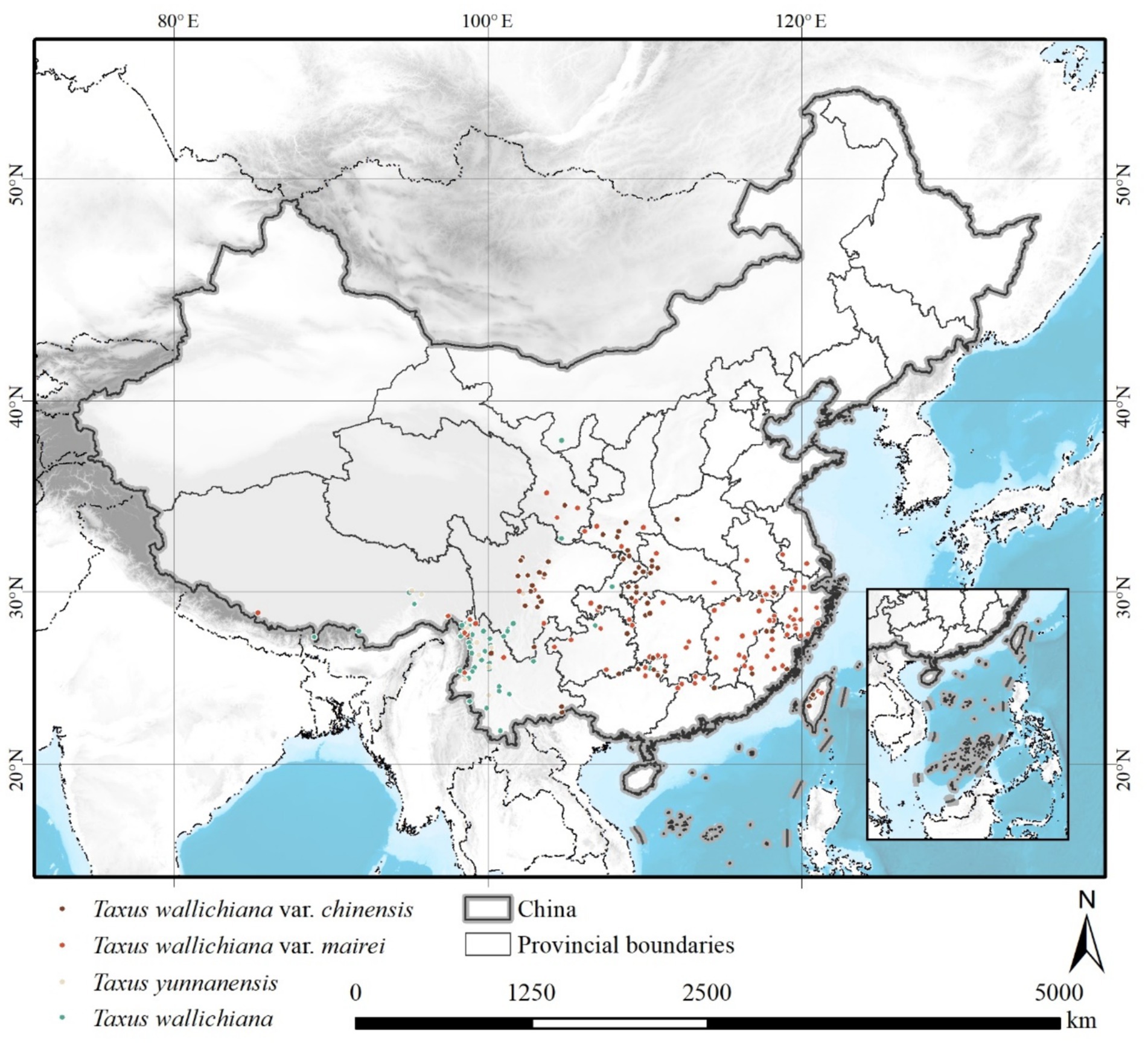
Figure 1. Distribution of occurrence points for four types of yew species.
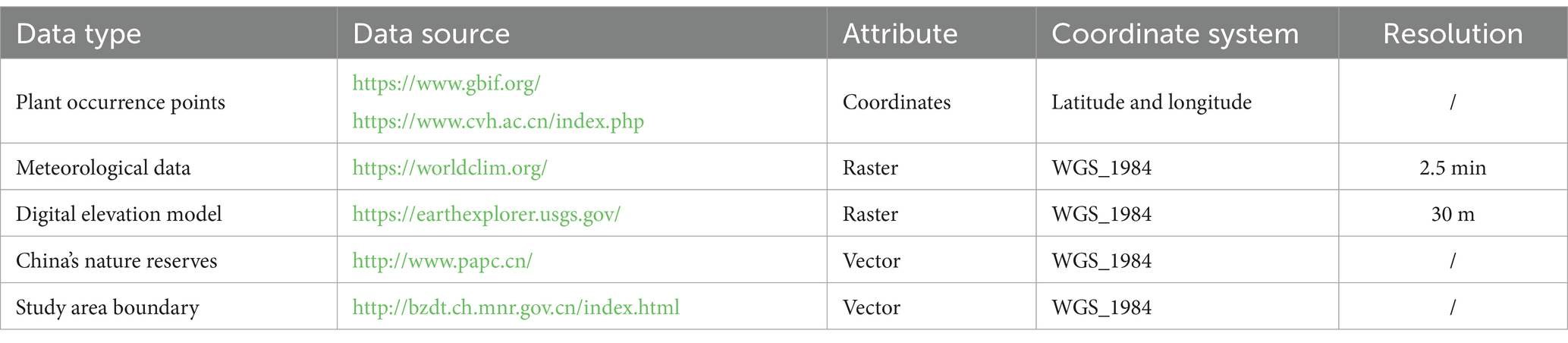
Table 1. Sources and attributes of research data.
This study uses spatial coordinate data of four types of yew species in southern China, along with 56 meteorological factors from 1970 to 2000, elevation and slope data, and the boundaries of China’s natural protected areas as the foundational data. The MaxEnt model is used to simulate the potential habitats of these four species. The model’s predictive accuracy is evaluated using the AUC curve, and the simulation results are classified into different levels. Finally, the classification results are overlaid with the boundaries of China’s natural protected areas, and the results are discussed. The research approach for this study is shown in Figure 2.
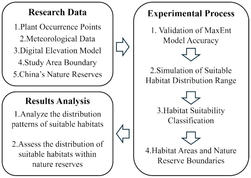
Figure 2. Research roadmap.
The concept of “Entropy” was first introduced in 1856 to describe the degree of disorder in a system. The entropy of a closed system increases over time, leading to a transition from order to disorder. In 1948, entropy was introduced into information theory by Shannon, used to represent the uncertainty of a source of information. Information entropy represents the average amount of information obtained when an event from the information source is received. Higher information content indicates greater uncertainty of the event. The mathematical expression for calculating information entropy is as follows (Equation 1):
In the formula, represents a random variable, and represents the probability distribution of the random variable.
In the theory of maximum entropy, a non-equilibrium living system must maintain its existence through the exchange of matter and energy with the environment. That is, any objectively existing living system is in a state of increasing system entropy, ultimately reaching equilibrium with the environment, where the system’s entropy is maximized (Tang et al., 2021). The MaxEnt model combines species distribution data with environmental factors, using Species Distribution Models (SDMs) to calculate the constraints of the species’ ecological niche (Yan et al., 2020; Khan et al., 2022). By calculating the probability distribution of the system in the state of maximum entropy, and based on this function, the distribution under the state of maximum entropy is fitted, constructing a spatial distribution model for the target species.
Let be the environmental factors, the number of environmental factors, with the constraint , being the number of constraints, where is the function of environmental factors, the constraints are represented as follows (Equation 2):
Using species distribution data to construct the function of environmental variables, the formula is as follows (Equation 3):
The formula for is given by Equation 4:
Based on the above function, to find the value of when reaches its maximum, the Lagrange multiplier method is used to solve this problem, thus constructing the function as follows (Equation 5):
The in Equation 5 is referred to as the Lagrange multiplier.
Next, we take the partial derivative of the function and set the partial derivatives equal to zero, resulting in the following set of equations (Equation 6):
Combine the constraint of Equation 2 with the set of equations in (6) to find the values of and when reaches its maximum. A larger value of indicates a higher likelihood of the target species’ presence in that area.
To ensure the accuracy of the MaxEnt model in predicting potential suitable habitats for the four types of Taxus species, this study used the Area Under the Receiver Operating Characteristic Curve (AUC) to evaluate the performance of different model parameters. The AUC value is an indicator of model prediction accuracy, with values closer to 1 indicating higher accuracy. In the parameter optimization process, occurrence data for Taxus species was combined with 56 climate data variables, as well as elevation and slope topographic data, to construct two explanatory variable models: a linear function model and a quadratic function model. The MaxEnt model was run using ArcGIS Pro 3.0 software, generating ROC curves for the two different function settings. The AUC values under different function conditions were calculated and compared. AUC values range from 0.5 to 1, with values closer to 1.0 indicating higher model accuracy; a value of 0.5 indicates the lowest accuracy and has no practical application.
Using Taxus distribution data and environmental factors, this study constructed a habitat suitability map for Taxus species in China. By overlaying this with the ranges of nature reserves across various regions, the study provides conservation recommendations from a macro-level geographic perspective. The methodology includes the MaxEnt model and overlay analysis, implemented using ArcGIS 10.6 and the MaxEnt model in ArcGIS Pro 3.0. By gathering the spatial location data of Taxus occurrences, the distribution data of potential suitable habitats for Taxus were constructed. The suitable habitats were then classified into different levels, and an overlay analysis was conducted with the boundaries of nature reserves. This identified nature reserves suitable for Taxus growth and assessed which reserves could serve as key areas for conservation and reintroduction of Taxus.
For the classification of suitable habitats, this study referred to the classification standards for species suitability evaluation set by the IPCC (Intergovernmental Panel on Climate Change). The MaxEnt model results for Taxus habitats were classified into four levels of suitability: habitat suitability (p) < 0.05 as unsuitable; 0.05 ≤ p < 0.33 as low suitability; 0.33 ≤ p < 0.66 as medium suitability; and p ≥ 0.66 as high suitability (Kong et al., 2021).
The ultimate goal of overlay analysis is typically to provide information for decision-making. Nature reserves in China are designated to protect biodiversity, representative natural ecosystems, and natural resources. Due to their inclusion within the boundaries of ecological protection red lines, these areas are less likely to be affected by social activities, and their natural environments generally exhibit strong stability. In this study, nature reserves were used as units, and the reserve boundaries were overlaid with the simulated potential suitable habitats for Taxus species to identify highly suitable reserve areas, providing a basis for targeted conservation decisions for Taxus species. Overlay Analysis is a spatial analysis method used to integrate multiple geographic datasets and generate results within a single dataset. Through overlay analysis, users can evaluate the spatial relationships between different datasets to support decision-making. The principle of overlay analysis essentially involves superimposing the features of one geographic dataset with those of another to determine their relationships or interactions (Unwin, 1996; Walke et al., 2012).
The occurrence points for the four types of yew species, along with all environmental variables, were input into the MaxEnt model in ArcGIS Pro 3.0. This included 56 sets of climate data, as well as digital models for elevation and slope. The explanatory variables were set as linear functions and quadratic functions, respectively. The accuracy of the MaxEnt model was evaluated using the Area Under the Curve (AUC) of the Receiver Operating Characteristic (ROC) curve (Phillips et al., 2017; Soilhi et al., 2022). By comparing the AUC values of each species under different explanatory variable functions, the most suitable model for this study was determined. The horizontal axis of the ROC curve represents the false positive rate (specificity), while the vertical axis represents the true positive rate (sensitivity) (Shcheglovitova and Anderson, 2013). A larger AUC value indicates higher precision and accuracy, and when the AUC value exceeds 0.8, the prediction is considered good. By calculating the ROC curves for the four yew species under the two different explanatory variable functions (Figure 3), it was found that the AUC values calculated using the quadratic function were significantly higher than those calculated using the linear function (Table 2). Therefore, this study selected the suitability range calculated using the quadratic function as the research result. The AUC values of the MaxEnt models for the four types of yew species were 0.9604 (T. wallichiana var. chinensis.), 0.9410 (T. wallichiana var. mairei.), 0.9777 (T. wallichiana.), and 0.9893 (T. yunnanensis.), indicating that the prediction results are reliable (Table 2).
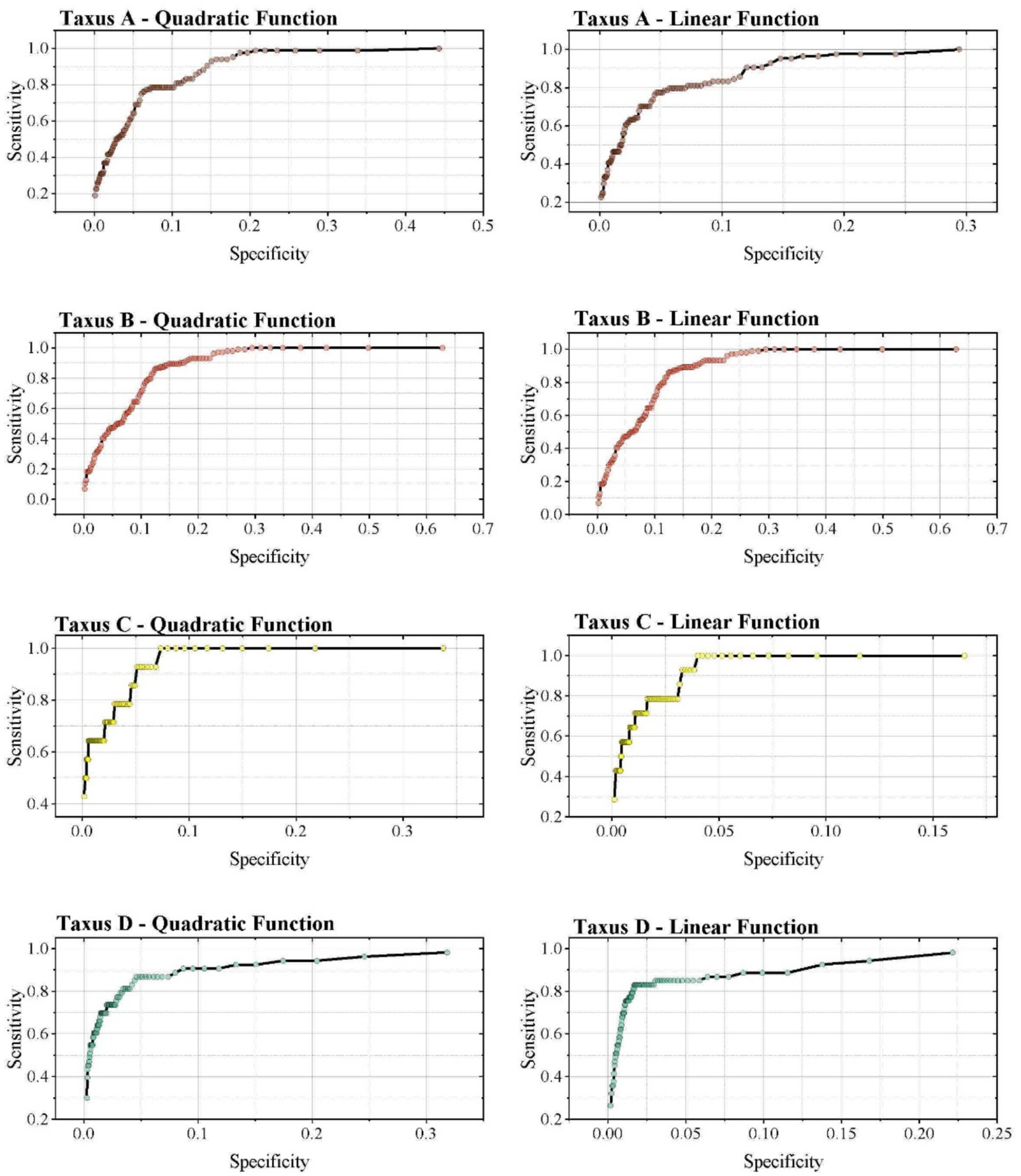
Figure 3. Characteristic curves of the four types of yew species under different function models. Taxus A-D represent, respectively: T. wallichiana var. chinensis, T. wallichiana var. mairei, T. wallichiana, and T. yunnanensis.
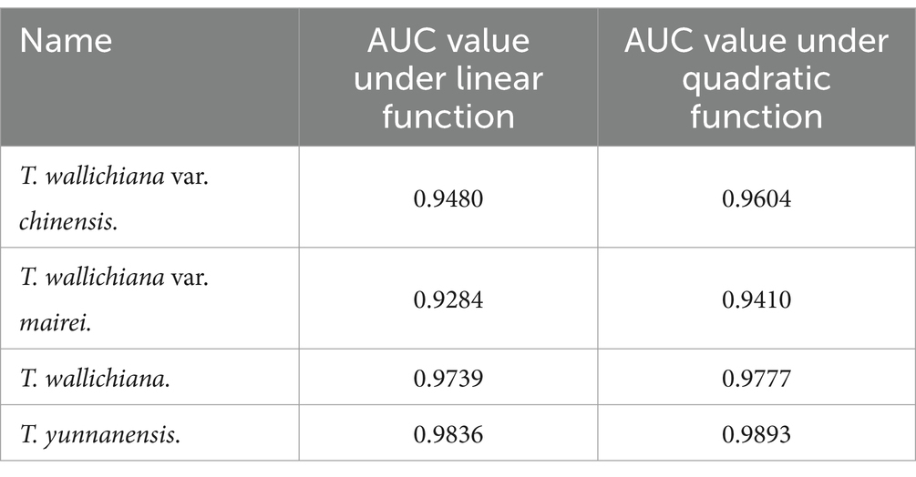
Table 2. AUC values of the four types of yew species under different function models.
Using the distribution records of yew species (Figure 1) and six key environmental factors, the MaxEnt model was applied to simulate the potential suitable habitats for the four Taxus species. The simulation results indicate that the potential suitable habitats for yews are predominantly located between 26°N and 31°N latitude, where the spatial heterogeneity of suitable habitats is quite high.
According to the IPCC’s classification standards for species suitability, the suitable habitats were divided into three levels: high suitability, medium suitability, and low suitability. In terms of habitat area, T. wallichiana var. mairei has the largest suitable habitat area in China, with a total area of 2,237,457.75 km2, including 490,320.25 km2 of high-suitability areas, 884,111.93 km2 of medium-suitability areas, and 863,025.57 km2 of low-suitability areas. T. wallichiana var. chinensis has the second largest suitable habitat area, with a total area of 1,365,378.06 km2, including 186,138.08 km2 of high-suitability areas, 381,170.26 km2 of medium-suitability areas, and 798,069.72 km2 of low-suitability areas. In comparison, the suitable habitat areas for T. wallichiana and T. yunnanensis are smaller and relatively similar. The total suitable habitat area for T. wallichiana is 497,992.74 km2, with 93,042.34 km2 of high-suitability areas, 121,033.5 km2 of medium-suitability areas, and 283,916.90 km2 of low-suitability areas. T. yunnanensis has a total suitable habitat area of 615,323.74 km2, including 111,707.75 km2 of high-suitability areas, 113,437.28 km2 of medium-suitability areas, and 390,178.71 km2 of low-suitability areas (Table 3). In terms of spatial distribution, T. wallichiana var. mairei has a broad suitable habitat range, covering Jiangxi, Fujian, Zhejiang, Chongqing, Hunan, Sichuan, Yunnan, and Tibet. The suitable habitat of T. wallichiana var. chinensis is concentrated in the Qinling-Daba Mountains (bordering Chongqing, Hubei, and Shaanxi), the Wuyi-Dabie-Nanling Mountains (surrounding Jiangxi), and the Hengduan Mountains in Sichuan. The distribution of T. wallichiana and T. yunnanensis is similar, primarily concentrated in the northwestern Hengduan Mountains in Sichuan and the southeastern Himalayas in Tibet. Overall, high-altitude mountainous regions are more suitable for the growth of Taxus species (Figure 4 and Table 4).
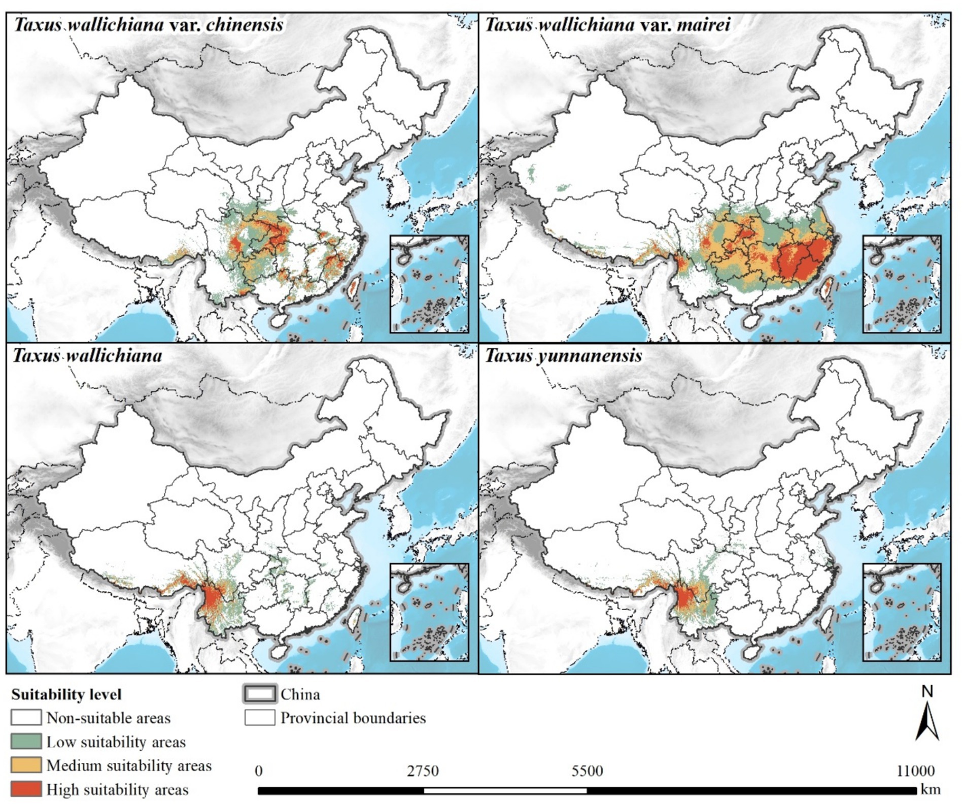
Figure 4. Distribution map of suitable habitats for the four types of yew species.
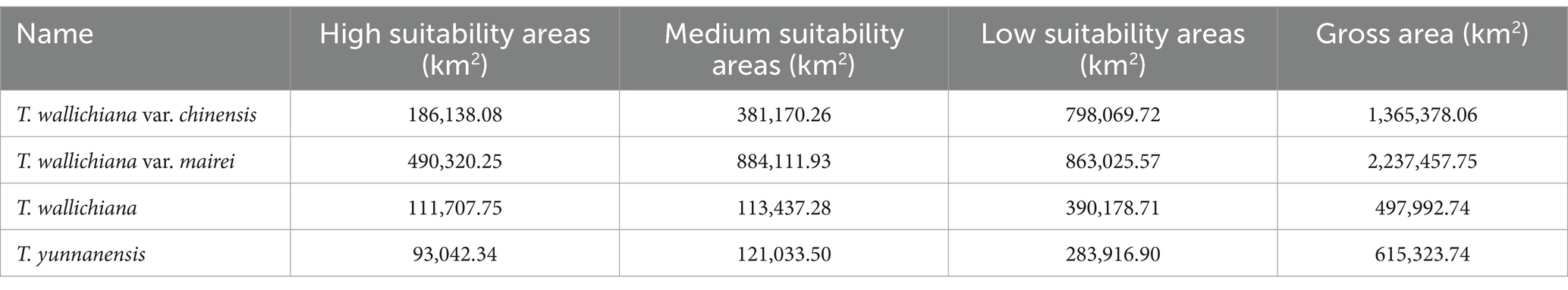
Table 3. Area of different suitability levels for the four types of yew species.
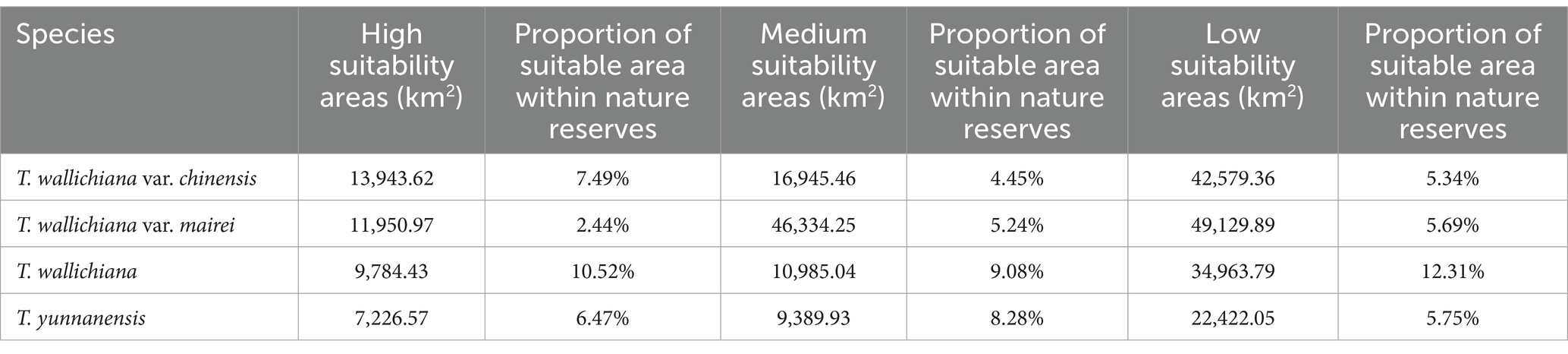
Table 4. Area of different suitability levels for the four types of yew species within nature reserves.
Nature reserves play a critical role in maintaining the most pristine and intact forest ecosystems, as well as the richest biodiversity. Protecting biodiversity through nature reserves can achieve significant results both in terms of ecosystem diversity and species and genetic diversity. To assess the relationship between the suitable habitats of yews and domestic nature reserves, an overlay analysis was conducted, superimposing the suitable habitat areas with the boundaries of nature reserves (Figure 5), and the distribution of high-suitability areas within each nature reserve was calculated. The calculation results show that the area of high-suitability zones for T. wallichiana var. chinensis within nature reserves is 13,943.62 km2, covering 7.49% of its high-suitability areas. The area of high-suitability zones for T. wallichiana var. mairei within nature reserves is 11,950.97 km2, covering 2.44%. For T. wallichiana, nature reserves cover 9,784.43 km2 of high-suitability areas, accounting for 10.52%, while for T. yunnanensis, reserves cover 7,226.57 km2, or 6.47%, of its high-suitability areas. T. wallichiana has the highest proportion of high-suitability zones within nature reserves, followed by T. wallichiana var. chinensis, then T. yunnanensis. T. wallichiana var. mairei has the lowest proportion, primarily due to the relatively large size of its overall suitable habitat (Table 4).
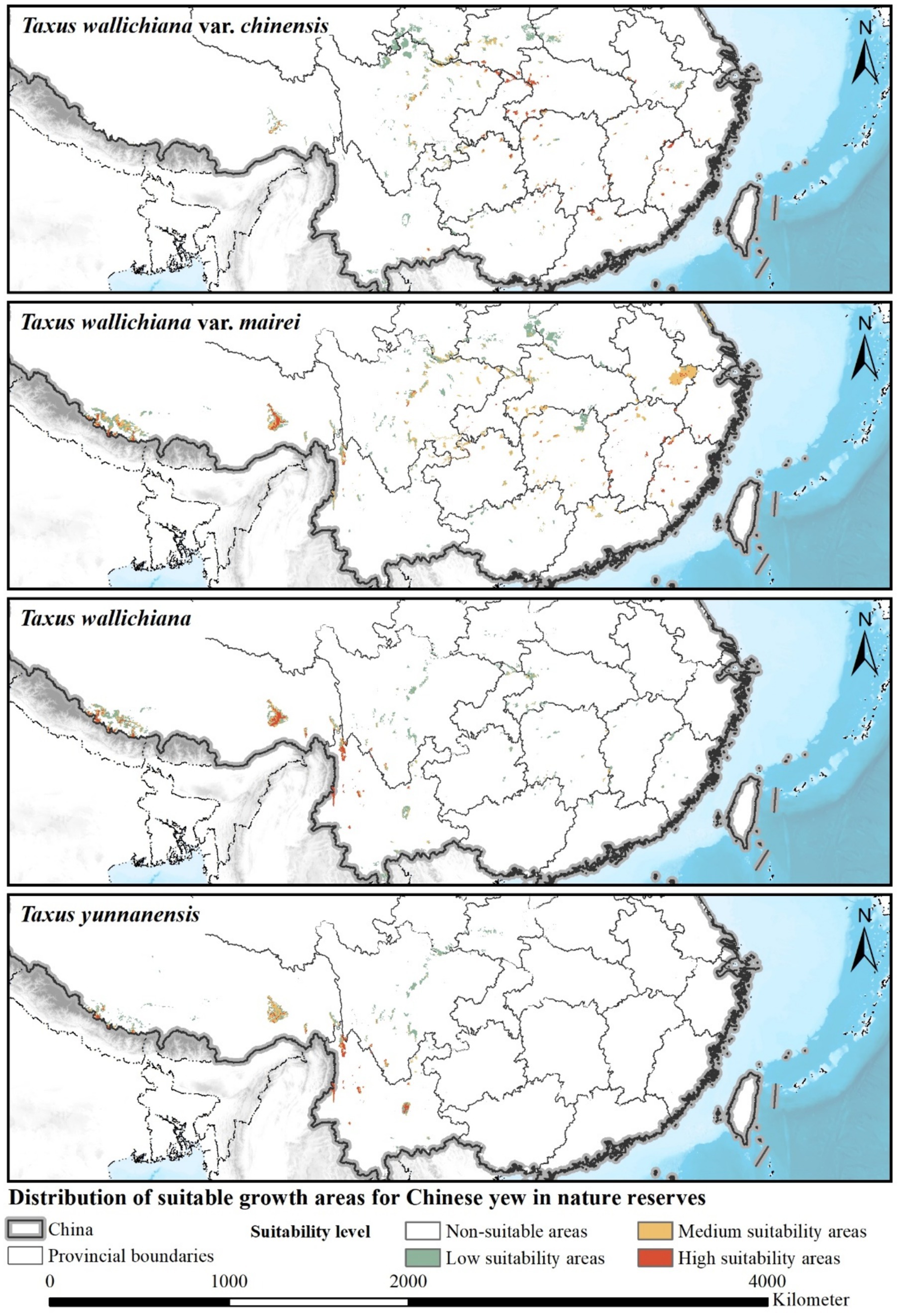
Figure 5. Distribution of suitable habitats for the four types of yew species within nature reserves.
The high-suitability areas of T. wallichiana var. chinensis covered by nature reserves are mainly concentrated in two regions: the Qinling and Dabie Mountain areas, and the Wuyi Mountains and Nanling region. However, the central Sichuan region of the Hengduan Mountains, where there is a broader distribution of high-suitability areas for T. wallichiana var. chinensis, has relatively low coverage by nature reserves. It is recommended to explore conservation and reintroduction efforts for T. wallichiana var. chinensis in this region, particularly in Sichuan Wolong National Nature Reserve, Sichuan Fengtongzhai National Nature Reserve, and Sichuan Baishuihe National Nature Reserve. The high-suitability areas for T. wallichiana var. mairei covered by nature reserves are mainly concentrated in the Wuyi Mountains and Nanling region. In southern Tibet, the Yarlung Zangbo Grand Canyon National Nature Reserve and the Qomolangma National Nature Reserve also have relatively high coverage. However, the high-suitability areas in the Qinling and Dabie Mountains, as well as the Hengduan Mountains, have relatively low coverage by nature reserves. The coverage of high-suitability areas for T. wallichiana and T. yunnanensis by nature reserves is similar. In southwestern Hengduan Mountains, nature reserves such as the Gaoligong Mountains National Nature Reserve, Yunlong Tianchi National Nature Reserve, and Cangshan Erhai National Nature Reserve, as well as the Yongde Snow Mountain National Nature Reserve, have a higher coverage of these areas. In southern Tibet, T. wallichiana enjoys a much higher degree of coverage compared to T. yunnanensis.
This study focuses on four species of yew in southern China and uses the MaxEnt model to simulate the distribution characteristics of their potential habitats. The simulation results indicate that T. wallichiana var. mairei and T. wallichiana var. chinensis have relatively wide distribution in suitable habitats within China, particularly concentrated in mountainous areas between latitudes 26°N and 31°N. These areas include the Wuyi Mountains, Dabie Mountains, Qinling Mountains, and Nanling Mountains ranges. Among these, T. wallichiana var. mairei has the broadest range, with high-suitability areas covering most of Jiangxi, Fujian, and Zhejiang provinces, and also forming a significant distribution around the Qinling region in Chongqing, Sichuan, and Yunnan. This distribution pattern reflects T. wallichiana var. mairei strong environmental adaptability and potential for reintroduction. The suitable habitat for T. wallichiana var. chinensis is primarily concentrated in the Qinling, Daba, and Wuyi Mountains. Although its distribution range and suitable habitat area are noticeably smaller than those of T. wallichiana var. mairei, the presence of multiple, non-contiguous areas demonstrates substantial potential for population expansion. In contrast, the suitable habitats of T. wallichiana and T. yunnanensis are more spatially restricted. Both are mainly distributed in the Hengduan Mountains in northwestern Sichuan and the southeastern Himalayas in Tibet, where these areas exhibit spatial connectivity and share similar climatic environments. Geographically, these regions are distant from major human activity areas. The harsh natural conditions and ecological sensitivity from the southeastern Himalayas to the northern Hengduan Mountains make these areas susceptible to social influences, creating a unique natural environment. The distinctive natural conditions and relatively extreme climate limit biological movement, constraining the distribution and suitable habitat range of these two yew species.
In summary, T. wallichiana var. mairei and T. wallichiana var. chinensis exhibit greater reintroduction potential and are suitable for expansion and propagation in a broader range of environments. In contrast, T. wallichiana and T. yunnanensis are restricted to specific environments and regions, with limited suitable habitat indicating a high dependence on their habitats. These findings have implications for developing targeted conservation strategies for different yew species. For the widely distributed T. wallichiana var. mairei and T. wallichiana var. chinensis, it is advisable to expand the protected area network to strengthen population stability. For the more restricted T. wallichiana and T. yunnanensis, habitat protection should be intensified to mitigate potential threats from external disturbances and environmental changes.
Based on the overlay analysis results in section 3.3, the overlap between potential Taxus habitats and domestic nature reserves was identified. The results indicate that nature reserves within major mountainous regions in southern China, primarily the Qinling, Hengduan, Wuyi, and Himalayan mountain ranges, provide ideal habitats for the survival and propagation of Taxus species. These reserves, characterized by rich biodiversity and intact forest ecosystems, offer a highly naturalized environment that provides stable growth space for flora and fauna and suitable natural conditions for Taxus propagation and reintroduction.
Specifically, T. wallichiana has the highest proportion of its high-suitability area covered by nature reserves (10.52%), followed by T. wallichiana var. chinensis at 7.49%, T. yunnanensis at 6.47%, and T. wallichiana var. mairei at 2.44%, which is lower due to its larger high-suitability area. Spatially, the high-suitability areas for T. wallichiana var. chinensis are primarily concentrated in the Qinling, Dabie, Wuyi, and Nanling mountain regions, with some areas located within existing nature reserves. However, central Sichuan’s Hengduan Mountains have less coverage in high-suitability areas. To increase conservation coverage for T. wallichiana var. chinensis in this region, it is recommended to implement reintroduction and cultivation efforts within national nature reserves such as Wolong, Fengtongzhai, and Baishuihe to support its expansion potential. The suitable habitat for T. wallichiana var. mairei is widely distributed, with major reserves located in the Wuyi Mountains, southeastern Himalayas, and Nanling. In southern Tibet, the Yarlung Zangbo Grand Canyon and Qomolangma National Nature Reserves cover large high-suitability areas for T. wallichiana var. mairei. For regions with numerous nature reserves, such as the Qinling, Wuyi, and Hengduan mountains, it is suggested to establish ecological corridors connecting the reserves to protect biodiversity and optimize the habitat for Taxus propagation.
Taxus wallichiana is mainly distributed in the southern Himalayas, where high altitude and ecological fragility make it dependent on reserves to maintain ecosystem stability. The coverage of T. wallichiana within reserves in this region is significantly higher than elsewhere, making the Yarlung Zangbo Grand Canyon and Qomolangma National Nature Reserves valuable seed sources for enhancing population stability and sustainability.
For T. yunnanensis, high-suitability areas are concentrated in the southwestern Hengduan Mountains, including reserves such as Gaoligongshan, Yunlong Tianchi, Cangshan Erhai, and Yongde Snow Mountain National Nature Reserves, providing ample space for T. yunnanensis propagation. It is recommended to continue reintroduction and conservation projects within these reserves to strengthen the population structure of T. yunnanensis.
Overall, nature reserves within Taxus suitable habitat ranges should be prioritized as key areas for Taxus population development. Nature reserves in the Qinling, Hengduan, southern Himalayas, and Wuyi Mountains should be targeted for Taxus reintroduction and cultivation. From the perspective of reserve management, enhancing protection within reserves, increasing biodiversity, and strengthening ecosystem stability will provide long-term protection for Taxus populations.
The research results indicate that the habitats of many species of yew are currently not effectively protected, and human activities have significantly impacted species distribution (Kong et al., 2021). Protected areas are an effective means of safeguarding species from the continuous threats of human activities, but changes in environmental factors can still lead to shifts in their distribution ranges (Gao et al., 2022). Landscape patches and habitat fragmentation can become obstacles to plant dispersal (Tucker et al., 2018), while the construction of ecological corridors can promote the spread of plants through animal propagation (Fricke et al., 2022). Therefore, natural protected areas within the suitable habitats of yew, especially in regions such as the Qinling Mountains, Hengduan Mountains, southern Himalayas, and Wuyi Mountains, should be prioritized as key areas for future yew population cultivation. Conservation efforts for yew species should not be limited to current protected area distributions; the establishment of small protected areas can increase the coverage of protected zones (Kong et al., 2021). For adjacent protected areas, constructing ecological corridors can enhance regional biodiversity and strengthen the stability of ecosystems.
The distribution of potential habitats for plants at large scales is the result of multiple factors. Temperature and precipitation are important factors influencing plant growth and reproduction. Previous studies have suggested that, compared to common species, endangered species are more vulnerable to climate change and human activities due to their small existing population sizes and limited habitat areas (Hetem et al., 2014; Köster et al., 2013). Relevant studies have shown that changes in temperature (Rathore et al., 2019), precipitation (Moir, 1999), and solar radiation (Dhar et al., 2006) can significantly affect the distribution of yew species, and changes in habitat can be considered a major alteration of forest site conditions (Falk and Mellert, 2011). Since forests play a crucial role in the global carbon cycle (Pan et al., 2011), research on suitable climate space changes and tree species distribution can provide valuable information for forest carbon management.
SDM models simulate the habitat range of target species, but they cannot represent the actual habitat distribution of the species (Falk and Mellert, 2011). The MaxEnt model used in this study, when predicting the potential habitat distribution of multiple species, did not fully consider various factors that affect species survival and reproduction, such as interspecies competition and the role of animals in aiding plant propagation and expansion (Deb et al., 2017). However, due to the lack of available data, some parameters that may influence the distribution of yew species in southern China were not considered. Therefore, the future direction of this study will involve multi-model coupling and the application of multi-source parameters (Elith et al., 2006).
This study conducted a systematic simulation of the potential suitable habitat distribution for four types of Taxus species in southern China and analyzed the coverage rate of high-suitability areas by nature reserves. The results showed that T. wallichiana var. mairei and T. wallichiana var. chinensis have a relatively wide distribution of suitable habitats, mainly concentrated in the Qinling, Wuyi, and Nanling mountain regions, with numerous areas available for reintroduction and propagation. In contrast, the suitable habitats for T. wallichiana and T. yunnanensis are more limited, primarily concentrated in the Hengduan and southern Himalaya mountain ranges. For future Taxus conservation efforts, the reserve network should be expanded to strengthen population stability for T. wallichiana var. mairei and T. wallichiana var. chinensis, with active efforts for reintroduction in multiple areas. For T. wallichiana and T. yunnanensis, habitat protection efforts should be intensified to address environmental changes and human activity disturbances. The coverage rate of high-suitability areas by nature reserves varies among the yew species, with T. wallichiana having the highest coverage rate, followed by T. wallichiana var. chinensis and T. yunnanensis, while T. wallichiana var. mairei has the lowest due to its widespread suitable habitat. Nature reserves provide a favorable environment for Taxus species, but the coverage of high-suitability areas remains insufficient. It is recommended to use high-suitability areas as a basis for expanding the reserve network, establishing ecological corridors, and implementing reintroduction and cultivation to enhance population stability. The limitations of this study are that the simulation results mainly rely on climate and topography data, without fully considering the impact of ecological factors such as human interference, soil factors, and interspecies competition on Taxus distribution. Future studies should integrate more environmental variables and use dynamic monitoring methods to further optimize the layout of nature reserves, providing more comprehensive scientific support for the sustainable conservation of Taxus species and the construction of ecological corridors.
The original contributions presented in the study are included in the article/supplementary material, further inquiries can be directed to the corresponding authors.
YZ: Writing – original draft, Writing – review & editing. JH: Data curation, Formal analysis, Supervision, Writing – review & editing. GX: Resources, Writing – review & editing. YS: Writing – review & editing. ML: Data curation, Formal analysis, Funding acquisition, Writing – review & editing.
The author(s) declare that no financial support was received for the research, authorship, and/or publication of this article.
The authors declare that the research was conducted in the absence of any commercial or financial relationships that could be construed as a potential conflict of interest.
All claims expressed in this article are solely those of the authors and do not necessarily represent those of their affiliated organizations, or those of the publisher, the editors and the reviewers. Any product that may be evaluated in this article, or claim that may be made by its manufacturer, is not guaranteed or endorsed by the publisher.
Chauvier, Y., Descombes, P., Guéguen, M., Boulangeat, L., Thuiller, W., and Zimmermann, N. E. (2022). Resolution in species distribution models shapes spatial patterns of plant multifaceted diversity. Ecography 2022:e05973. doi: 10.1111/ecog.05973
De Kort, H., Prunier, J., Ducatez, S., Honnay, O., Baguette, M., Stevens, V., et al. (2021). Life history, climate and biogeography interactively affect worldwide genetic diversity of plant and animal populations. Nat. Commun. 12:516. doi: 10.1038/s41467-021-20958-2
Deb, J. C., Phinn, S., Butt, N., and McAlpine, C. A. (2017). Climatic-induced shifts in the distribution of teak (Tectona grandis) in tropical Asia: implications for Forest management and planning. Environ. Manag. 60, 422–435. doi: 10.1007/s00267-017-0884-6
Dhar, A., Ruprecht, H., Klumpp, R., and Vacik, H. (2006). Stand structure and natural regeneration of Taxus baccata at ‘Stiwollgraben’ in Austria. Dendrobiology 56, 19–26.
Elith, J., Graham, C. H., Anderson, R. P., Dudik, M., Ferrier, S., Guisan, A., et al. (2006). Novel methods improve prediction of species’ distributions from occurrence data. Ecography 29, 129–151. doi: 10.1111/j.2006.0906-7590.04596.x
Falk, W., and Mellert, K. H. (2011). Species distribution models as a tool for forest management planning under climate change: risk evaluation of Abies alba in Bavaria. J. Veg. Sci. 22, 621–634. doi: 10.1111/j.1654-1103.2011.01294.x
Fitzgibbon, A., Pisut, D., and Fleisher, D. (2022). Evaluation of maximum entropy (Maxent) machine learning model to assess relationships between climate and corn suitability. Land 11:1382. doi: 10.3390/land11091382
Fricke, E. C., Ordonez, A., Rogers, H. S., and Svenning, J.-C. (2022). The effects of defaunation on plants’ capacity to track climate change. Science 375, 210–214. doi: 10.1126/science.abk3510
Gao, X., Liu, J., and Huang, Z. (2022). The impact of climate change on the distribution of rare and endangered tree Firmiana kwangsiensis using the Maxent modeling. Ecol. Evol. 12:e9165. doi: 10.1002/ece3.9165
Gebrewahid, Y., Abrehe, S., Meresa, E., Eyasu, G., Abay, K., Gebreab, G., et al. (2020). Current and future predicting potential areas of Oxytenanthera abyssinica (a. Richard) using MaxEnt model under climate change in northern Ethiopia. Ecol. Process. 9:6. doi: 10.1186/s13717-019-0210-8
Hao, T., Elith, J., Guillera-Arroita, G., and Lahoz-Monfort, J. J. (2019). A review of evidence about use and performance of species distribution modelling ensembles like BIOMOD. Divers. Distrib. 25, 839–852. doi: 10.1111/ddi.12892
Hetem, R. S., Fuller, A., Maloney, S. K., and Mitchell, D. (2014). Responses of large mammals to climate change. Temperature 1, 115–127. doi: 10.4161/temp.29651
Jose V, S., and Nameer, P. O. (2020). The expanding distribution of the Indian peafowl (Pavo cristatus) as an indicator of changing climate in Kerala, southern India: a modelling study using MaxEnt. Ecol. Indic. 110:105930. doi: 10.1016/j.ecolind.2019.105930
Khan, A. M., Li, Q., Saqib, Z., Khan, N., Habib, T., Khalid, N., et al. (2022). MaxEnt modelling and impact of climate change on habitat suitability variations of economically important Chilgoza pine (Pinus gerardiana Wall.) in South Asia. Forests 13:715. doi: 10.3390/f13050715
Kong, F., Tang, L., He, H., Yang, F., Tao, J., and Wang, W. (2021). Assessing the impact of climate change on the distribution of Osmanthus fragrans using Maxent. Environ. Sci. Pollut. Res. 28, 34655–34663. doi: 10.1007/s11356-021-13121-3
Köster, N., Kreft, H., Nieder, J., and Barthlott, W. (2013). Range size and climatic niche correlate with the vulnerability of epiphytes to human land use in the tropics. J. Biogeogr. 40, 963–976. doi: 10.1111/jbi.12050
Lee-Yaw, J. A., McCune, J. L., Pironon, S., and Sheth, S. N. (2022). Species distribution models rarely predict the biology of real populations. Ecography 2022:e05877. doi: 10.1111/ecog.05877
Li, Y., Li, M., Li, C., and Liu, Z. (2020). Optimized Maxent model predictions of climate change impacts on the suitable distribution of Cunninghamia lanceolata in China. Forests 11:302. doi: 10.3390/f11030302
Liu, L., Guan, L., Zhao, H., Huang, Y., Mou, Q., Liu, K., et al. (2021). Modeling habitat suitability of Houttuynia cordata Thunb (Ceercao) using MaxEnt under climate change in China. Eco. Inform. 63:101324. doi: 10.1016/j.ecoinf.2021.101324
Melo-Merino, S. M., Reyes-Bonilla, H., and Lira-Noriega, A. (2020). Ecological niche models and species distribution models in marine environments: a literature review and spatial analysis of evidence. Ecol. Model. 415:108837. doi: 10.1016/j.ecolmodel.2019.108837
Moir, A. K. (1999). The dendrochronological potential of modern yew (Taxus baccata) with special reference to yew from Hampton court palace, UK. New Phytol. 144, 479–488. doi: 10.1046/j.1469-8137.1999.00545.x
Pan, Y., Birdsey, R. A., Fang, J., Houghton, R., Kauppi, P. E., Kurz, W. A., et al. (2011). A large and persistent carbon sink in the World’s forests. Science 333, 988–993. doi: 10.1126/science.1201609
Phillips, S. J., Anderson, R. P., Dudík, M., Schapire, R. E., and Blair, M. E. (2017). Opening the black box: an open-source release of Maxent. Ecography 40, 887–893. doi: 10.1111/ecog.03049
Qin, H., Jin, X., and Zhao, L. (2020). “Rare and endangered plants in China” in Conservation and reintroduction of rare and endangered plants in China. ed. H. Ren (Singapore: Springer), 21–31.
Rathore, P., Roy, A., and Karnatak, H. (2019). Modelling the vulnerability of Taxus wallichiana to climate change scenarios in South East Asia. Ecol. Indic. 102, 199–207. doi: 10.1016/j.ecolind.2019.02.020
Shcheglovitova, M., and Anderson, R. P. (2013). Estimating optimal complexity for ecological niche models: a jackknife approach for species with small sample sizes. Ecol. Model. 269, 9–17. doi: 10.1016/j.ecolmodel.2013.08.011
Soilhi, Z., Sayari, N., Benalouache, N., and Mekki, M. (2022). Predicting current and future distributions of Mentha pulegium L. in Tunisia under climate change conditions, using the MaxEnt model. Eco. Inform. 68:101533. doi: 10.1016/j.ecoinf.2021.101533
Su, J., Yan, Y., Song, J., Li, J., Mao, J., Wang, N., et al. (2018). Recent fragmentation may not Alter genetic patterns in endangered Long-lived species: evidence from Taxus cuspidata. Front. Plant Sci. 9. doi: 10.3389/fpls.2018.01571
Sun, L., Ding, S., Luo, Q., Wang, P., Yang, X., Wu, L., et al. (2021). Taxus wallichiana var. chinensis (Pilg.) florin aqueous extract suppresses the proliferation and metastasis in lung carcinoma via JAK/STAT3 signaling pathway. Front. Pharmacol. 12:736442. doi: 10.3389/fphar.2021.736442
Tang, X., Yuan, Y., Li, X., and Zhang, J. (2021). Maximum entropy modeling to predict the impact of climate change on pine wilt disease in China. Front. Plant Sci. 12:652500. doi: 10.3389/fpls.2021.652500
Townsend Peterson, A., Papeş, M., and Eaton, M. (2007). Transferability and model evaluation in ecological niche modeling: a comparison of GARP and Maxent. Ecography 30, 550–560. doi: 10.1111/j.0906-7590.2007.05102.x
Tucker, M. A., Böhning-Gaese, K., Fagan, W. F., Fryxell, J. M., van Moorter, B., Alberts, S. C., et al. (2018). Moving in the Anthropocene: global reductions in terrestrial mammalian movements. Science 359, 466–469. doi: 10.1126/science.aam9712
Unwin, D. (1996). “Integration through overlay analysis” in Spatial analytical perspectives on GIS. Eds. Michael F. Goodchild, Michael J. Fisher, and David J. Unwin (London: Taylor & Francis). Available at: https://www.taylorfrancis.com/chapters/edit/10.1201/9780203739051-9/integration-overlay-analysis-david-unwin
Walke, N., Obi Reddy, G. P., Maji, A. K., and Thayalan, S. (2012). GIS-based multicriteria overlay analysis in soil-suitability evaluation for cotton (Gossypium spp.): a case study in the black soil region of Central India. Comput. Geosci. 41, 108–118. doi: 10.1016/j.cageo.2011.08.020
Wang, T., Chen, Y., Zhuang, W., Zhang, F., Shu, X., Wang, Z., et al. (2019). Transcriptome sequencing reveals regulatory mechanisms of Taxol synthesis in Taxus wallichiana var. Mairei. Int. J. Genomics 2019:e1596895. doi: 10.1155/2019/1596895
Wang, J., Qian, Q., Jia, X., Yu, B., Sun, C., and Tao, Q. (2023). The possible impact of human activity and climate change on the potential suitable habitats of Taxus wallichianavar. mairei (Taxaceae) evaluated by ensemble modeling techniques. Environ. Res. Commun. 5:105006. doi: 10.1088/2515-7620/acfdf9
Wang, C.-J., Wan, J.-Z., Zhang, Z.-X., and Zhang, G.-M. (2016). Identifying appropriate protected areas for endangered fern species under climate change. Springerplus 5:904. doi: 10.1186/s40064-016-2588-4
Wang, J., Wang, Y., Feng, J., Chen, C., Chen, J., Long, T., et al. (2019). Differential responses to climate and land-use changes in threatened Chinese Taxus species. Forests 10:766. doi: 10.3390/f10090766
West, A. M., Kumar, S., Brown, C. S., Stohlgren, T. J., and Bromberg, J. (2016). Field validation of an invasive species Maxent model. Eco. Inform. 36, 126–134. doi: 10.1016/j.ecoinf.2016.11.001
Wu, X., Wei, Y., Fu, B., Wang, S., Zhao, Y., and Moran, E. F. (2020). Evolution and effects of the social-ecological system over a millennium in China’s loess plateau. Sci. Adv. 6:eabc0276. doi: 10.1126/sciadv.abc0276
Xu, D., Zhuo, Z., Wang, R., Ye, M., and Pu, B. (2019). Modeling the distribution of Zanthoxylum armatum in China with MaxEnt modeling. Global Ecol. Conserv. 19:e00691. doi: 10.1016/j.gecco.2019.e00691
Yan, H., Feng, L., Zhao, Y., Feng, L., Wu, D., and Zhu, C. (2020). Prediction of the spatial distribution of Alternanthera philoxeroides in China based on ArcGIS and MaxEnt. Global Ecol. Conserv. 21:e00856. doi: 10.1016/j.gecco.2019.e00856
Yi, Y., Cheng, X., Yang, Z.-F., and Zhang, S.-H. (2016). Maxent modeling for predicting the potential distribution of endangered medicinal plant (H. riparia Lour) in Yunnan, China. Ecol. Eng. 92, 260–269. doi: 10.1016/j.ecoleng.2016.04.010
Zhang, Y., Tang, J., Ren, G., Zhao, K., and Wang, X. (2021). Global potential distribution prediction of Xanthium italicum based on Maxent model. Sci. Rep. 11:16545. doi: 10.1038/s41598-021-96041-z
Zhao, G., Cui, X., Sun, J., Li, T., Wang, Q., Ye, X., et al. (2021). Analysis of the distribution pattern of Chinese Ziziphus jujuba under climate change based on optimized biomod2 and MaxEnt models. Ecol. Indic. 132:108256. doi: 10.1016/j.ecolind.2021.108256
Keywords: Taxus species, MaxEnt model, habitat suitability simulation, nature reserve, Receiver Operating Characteristic Curve
Citation: Zhou Y, Hu J, Xie G, Shao Y and Liu M (2025) Simulation of potential suitable areas and analysis of natural reserves for four species of Taxus in southern China. Front. For. Glob. Change. 8:1346224. doi: 10.3389/ffgc.2025.1346224
Edited by:
Kourosh Ahmadi, Tarbiat Modares University, IranReviewed by:
Kevin Cianfaglione, Lille Catholic University, FranceCopyright © 2025 Zhou, Hu, Xie, Shao and Liu. This is an open-access article distributed under the terms of the Creative Commons Attribution License (CC BY). The use, distribution or reproduction in other forums is permitted, provided the original author(s) and the copyright owner(s) are credited and that the original publication in this journal is cited, in accordance with accepted academic practice. No use, distribution or reproduction is permitted which does not comply with these terms.
*Correspondence: Mu Liu, bGl1bXUwMzEyQGp4YXUuZWR1LmNu; Yakui Shao, c3lrMjI3ODE2X2dpc0AxNjMuY29t
Disclaimer: All claims expressed in this article are solely those of the authors and do not necessarily represent those of their affiliated organizations, or those of the publisher, the editors and the reviewers. Any product that may be evaluated in this article or claim that may be made by its manufacturer is not guaranteed or endorsed by the publisher.
Research integrity at Frontiers
Learn more about the work of our research integrity team to safeguard the quality of each article we publish.