 Lei Zhao
 Yi He
Yi He Wanqing Liu1,2*
95% of researchers rate our articles as excellent or good
Learn more about the work of our research integrity team to safeguard the quality of each article we publish.
Find out more
ORIGINAL RESEARCH article
Front. For. Glob. Change , 18 May 2023
Sec. Forest Hydrology
Volume 6 - 2023 | https://doi.org/10.3389/ffgc.2023.1187515
This article is part of the Research Topic Effects of Forest Disturbance on Hydrological Processes View all 4 articles
Introduction: The Danjiang River Basin has experienced significant alterations to its runoff patterns in recent years, primarily as a result of climate change and anthropogenic activities.
Methods: This study aims to investigate these factors’ influence on the basin’s runoff between 1960 and 2016 using the Mann–Kendall (M-K) test and Accumulative Anomaly Curve (AAC) to assess the abrupt change characteristics of runoff. Furthermore, the study evaluates the effects of climate and anthropogenic factors on runoff evolution using eight independent Budyko hypotheses.
Results: The findings indicate that annual precipitation in the basin remained stable (P > 0.1), while annual runoff decreases significantly to −4.08 mm/a (P < 0.05) and the annual potential evapotranspiration slightly decreases to −1.76 mm/a (P < 0.05). The study also reveales that the reduction of runoff is primarily attributable to anthropogenic activities, contributing between 133.66 and 147.50%, while climate change contributes between −33.66 and −47.50%.
Discussion: The increased vegetation cover in the basin is identified as the primary cause of the reduction in runoff production and increase in evapotranspiration. Additionally, the construction of hydraulic engineering facilities in the basin is found to have had some impact on reducing runoff. These findings have significant implications for water resource management and soil and water conservation in the Danjiang River Basin.
Access to water resources is essential for the economic, social, and sustainable development of human society. However, the current shortage of water resources has become a cause for concern. River runoff, as a critical component of water resources, significantly affects the water cycle (Ching and Mukherjee, 2015; Miao et al., 2016). Recently, the increasing influence of climate change and anthropogenic activities on water resources patterns has made it necessary to identify the main driving factors of changes in river runoff. As a result, numerous scholars have adopted various quantitative analysis methods to study changes in river runoff under the influence of climate change and anthropogenic activities (Brown et al., 2005; He et al., 2017, 2022; Wang et al., 2019; Yang et al., 2021). Research has shown that changes in runoff in the basin are mainly caused by the combined effects of anthropogenic activities and climate change. Climate change primarily includes precipitation and evapotranspiration, while anthropogenic activities mainly alter surface parameters such as afforestation, land use pattern changes, and hydraulic engineering construction, which affect the basin’s underlying surface parameters and thus influence runoff (Zhao et al., 2017; Qing et al., 2018; He et al., 2019; Zhou et al., 2020). Although hydrological models and Multiple Statistical Analysis (MSA) have been used to quantitatively analyze runoff variations in the basin, these methods can pose challenges in model and parameter calibration (Xu, 1999; Li et al., 2009). The hydrothermal coupling equilibrium equation theory, proposed by Budyko, is an effective means of analyzing long time series variations in watershed runoff. The theory’s simplicity and limited number of parameters in the equation reduce parameter uncertainty, and it has been widely used in recent years (Jiang et al., 2022).
The Danjiang River Basin is a crucial area for water resources management in China. This study’s results provide valuable information for decision-making and planning in the region. By analyzing the drivers of runoff changes using Budyko-based methods, this study can help identify key factors affecting runoff and inform effective water resource management strategies. The South-North Water Transfer Project, which heavily relies on the Danjiang River Basin as a water source, highlights the significance of this research in ensuring water security in the area. Furthermore, the study’s findings contribute to a broader understanding of how climate change and anthropogenic activities impact water resources and can potentially guide water resource management strategies in other watersheds facing similar challenges.
The Danjiang River Basin, which is situated in Shaanxi Province, China, covers an area between 33°05′−34°05′ N and 109°30′−110°05′ E (Figure 1). The basin is dominated by the Danjiang River, a prominent river that flows for 390 kilometers through the region. The river originates from the south of the Qinling Mountains and runs from northwest to southeast, passing through Shangzhou, Danfeng, and Shangnan before entering Henan Province, where it flows into the Danjiangkou Reservoir. The Jingzi Guan Hydrology Station is responsible for monitoring the basin, which has a drainage area of 7,060 km2, an average annual precipitation of 961.58 mm, and an average annual runoff of 1.54 billion m3. The basin’s topography results in precipitation primarily occurring during summer and autumn, with the heaviest rainfall taking place from June to September. The basin’s vegetation is predominantly vertically differentiated, consisting of coniferous forests and mixed forests. This information has been previously documented in studies by Zhang et al. (2016), Li et al. (2018), and Xu et al. (2019).
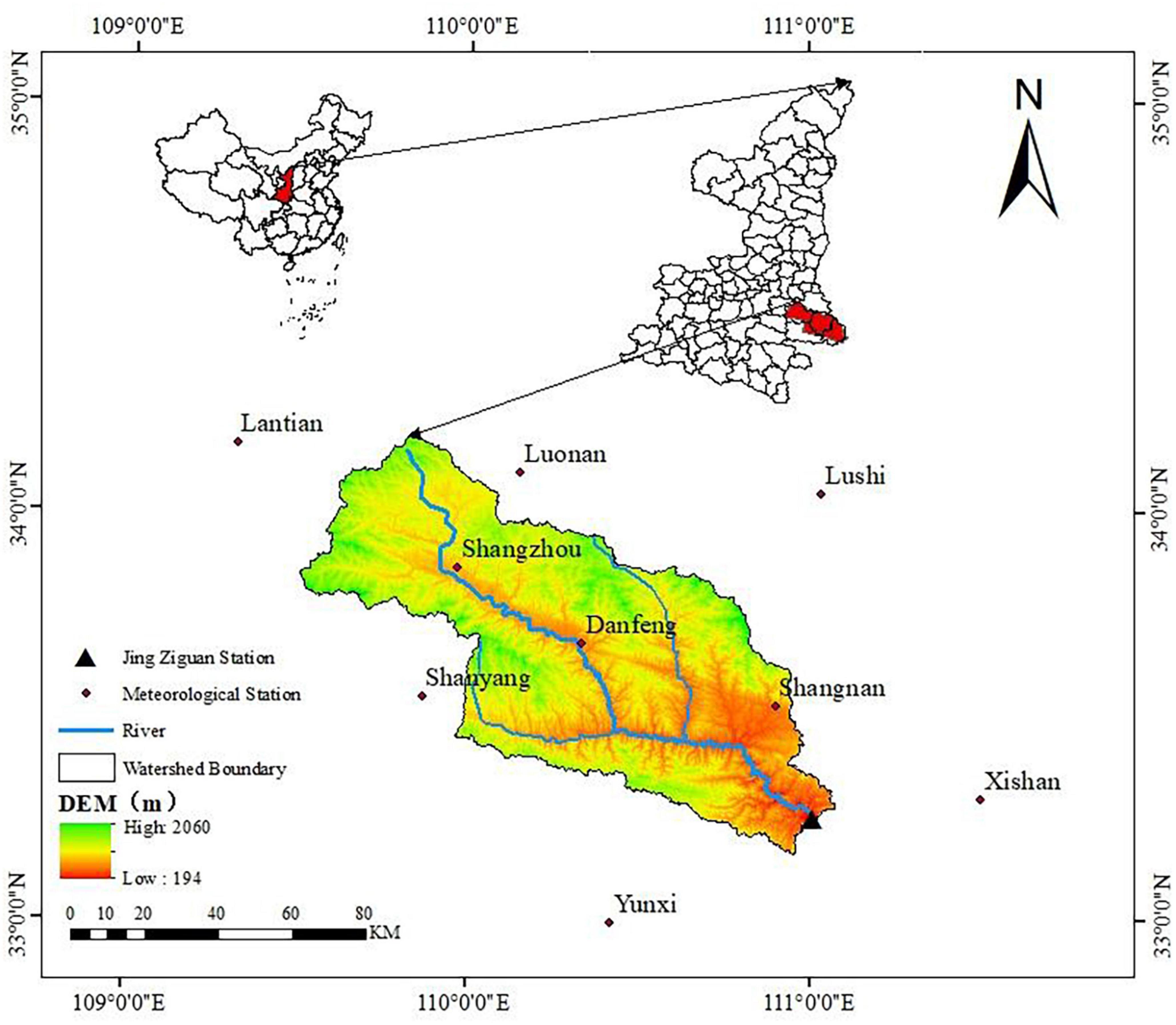
Figure 1. The location and research area of the meteorological station in this study (The coordinate frameofthemapisGCS_Xian_1980).
The meteorological data utilized in this study are sourced from the National Meteorological Information Centre (NMIC) and covered a time frame ranging from 1960 to 2016. To conduct this analysis, data from a total of nine meteorological stations situated within the Danjiang River Basin and surrounding regions are included. The daily runoff data for the Jingzi Guan Hydrological control Station are acquired from both the Hydrological Data of the Yangtze River Basin and the Hydrological Yearbook of the People’s Republic of China. The Digital Elevation Model (DEM) data utilized is retrieved from the Geospatial Data Cloud, and the spatial resolution is 30-meter. The Normalized Difference Vegetation Index (NDVI) data with a spatial resolution of 8 km spanning from 1982 to 2016 is sourced from the National Data Center for Earth System Science, Ministry of Science and Technology, China. Finally, the Land Use and Land Cover (LUC) data used in this research are obtained from the Data Center for Resources and Environmental Sciences, Chinese Academy of Sciences, and covered the period from 1980 to 2015, the spatial resolution of the LUC is 30-meter.
The study employes linear trend estimation and M-K test developed by Mann (1945) and Kendall (1975) to analyze the long-term trends of annual runoff depth, annual rainfall, and annual potential evapotranspiration in the Danjiang River Basin from 1960 to 2016. M-K test method has been widely used to test the trend and mutation point of annual runoff series in watershed (Liu et al., 2018). If the Z value of the statistic tested by M-K method is positive, the sequence shows an upward trend, otherwise it shows a downward trend. If |Z| > 1.96, it indicated that the temporal trend is significant at the 0.05 significance level. The Z value is calculated as follows (Lou et al., 2019):
First, construct an order column S for the time series xn, where, xi and xj are the observed value of time series i and j, respectively (i < j).
And:
When n > 10, the statistic S roughly followed the normal distribution, and the mean E(S) = 0, Var(S) = n(n−1) (2n+5)/18. The statistical variables were normalized as:
To better identify abrupt changes in interannual variation, the study used the AAC method developed by He et al. (2016) and the M-K test to identify abrupt change points in the runoff of the Danjiang River Basin. This approach allowed for the division of the basin into base and change periods, ensuring accurate and reasonable identification of abrupt changes in the basin. The M-K abrupt test expressed as follows:
Define the statistic Sk:
Where the mean and Var of Sk can be represented by the following formula:
Standardize Sk:
Where UF1 = 0, given the significance level α, if | UFk| > Uα, showed that the sequence had obvious trend change. Reference this method to the inverse sequence can get the UBk.
For a given watershed under a long time series, its balance equation of water quantity can be expressed as:
Where P, E, Q, and ΔS represented in annual precipitation, annual actual evaporation, runoff depth and the change of basin water storage, the ΔS for a given watershed can be neglected in a long time series (Hang and Guan, 2011).
This study utilizes eight Budyko-based methods, which are categorized into two types: non-parametric and parametric equations. Table 1 provides the detailed equations used in the analysis, where the first four are non-parametric and the last four are parametric, as outlined by Wu and Miao (2017). These equations use precipitation (P), potential evapotranspiration (E0), and runoff (Q) to calculate their respective parameters, as listed in Table 1. To determine the drought index Φ, the ratio of potential evapotranspiration to precipitation is calculated, with values greater than 1 indicating wetter regions and values less than 1 indicating drier areas, as per the definition provided by Liu and Zhang (2013).
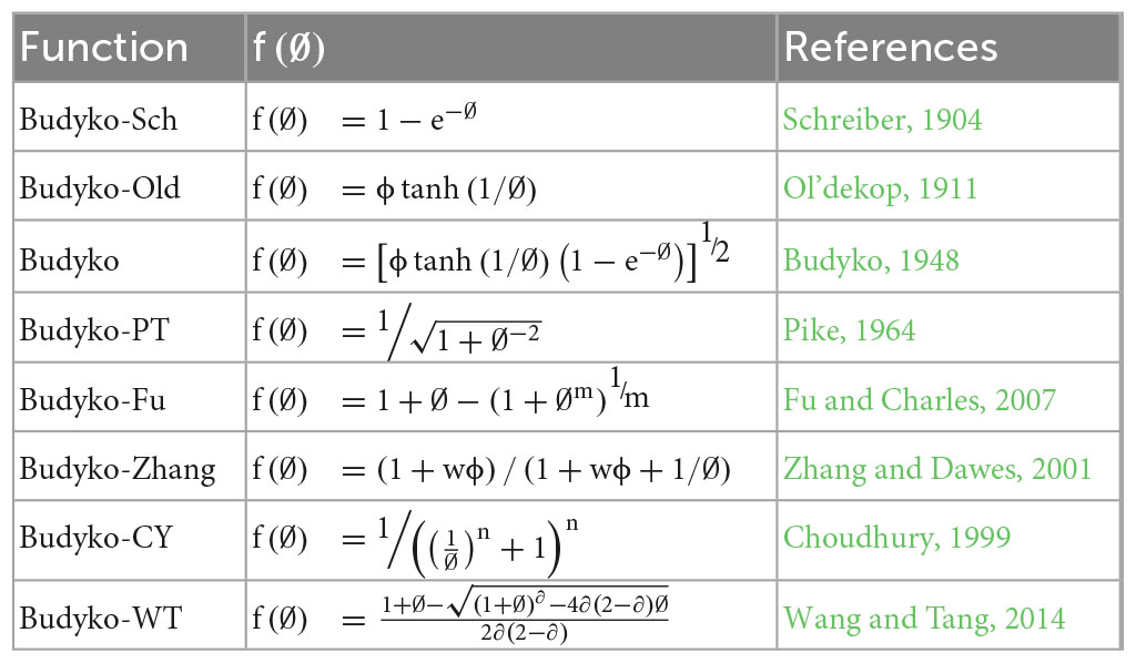
Table 1. The eight Budyko-Based equations and the n, m, w ∂ indicate the characteristic parameters of the subsurface of the basin.
Based on the equation for estimating actual evapotranspiration in the table, we could assume that P (precipitation) and E0 (potential evapotranspiration) are independent variables in the basin. Therefore, the change of watershed runoff caused by climate change can be expressed as follows:
The runoff elasticity coefficient of climate can be defined as:
Equation (9) can be expressed as:
Where, can be expressed as the precipitation elastic coefficient of runoff; is expressed as the potential evapotranspiration elastic coefficient of runoff. Where εP can be calculated according to the following formula:
Therefore, Equation (12) can be expressed as follows:
In the whole long time series, the period variation of runoff can be represented by the following formula:
represents the annual average runoff in the change period, represents the annual average runoff in the baseline period, and represents the total change in the period.
For a specific area, the total variation of runoff can also be expressed as:
is the runoff change that caused by climate and denotes the change in runoff from anthropogenic activities. On this basis, equations (18) and (19) are used to obtain the degree of influence of climate activities and anthropogenic activities on runoff change.
Recently, the acceleration of the water cycle in the Danjiang River Basin, caused by the increase in global temperature, has significantly impacted precipitation and evapotranspiration, ultimately affecting the runoff in the basin. Figure 2 presents the interannual variations of the hydrological elements in the basin between 1960 and 2016. Statistical analysis of the data indicates that the annual runoff depth in the basin decreased significantly at a rate of −4.083 mm/a (P < 0.05). The average annual runoff depth is 216.8/mm, with a maximum of 957.6/mm (in 1964), and a minimum of 44.5/mm (in 1999), demonstrating large inter-annual variation. However, the overall variation trend of annual precipitation in the basin is small and shows an insignificant downward trend (P > 0.1). The average annual precipitation is 730/mm, with a maximum of 1136.8/mm (in 1964) and a minimum of 528.7/mm (in 1986). Additionally, the annual potential evapotranspiration exhibites an insignificant decreasing trend, with a decreasing rate of −1.764 mm/a (P < 0.05). The average annual potential evapotranspiration is 961.58/mm, with an annual maximum potential evapotranspiration of 1124.8/mm (in 1978) and an annual minimum potential evapotranspiration of 825.1/mm (in 1989).
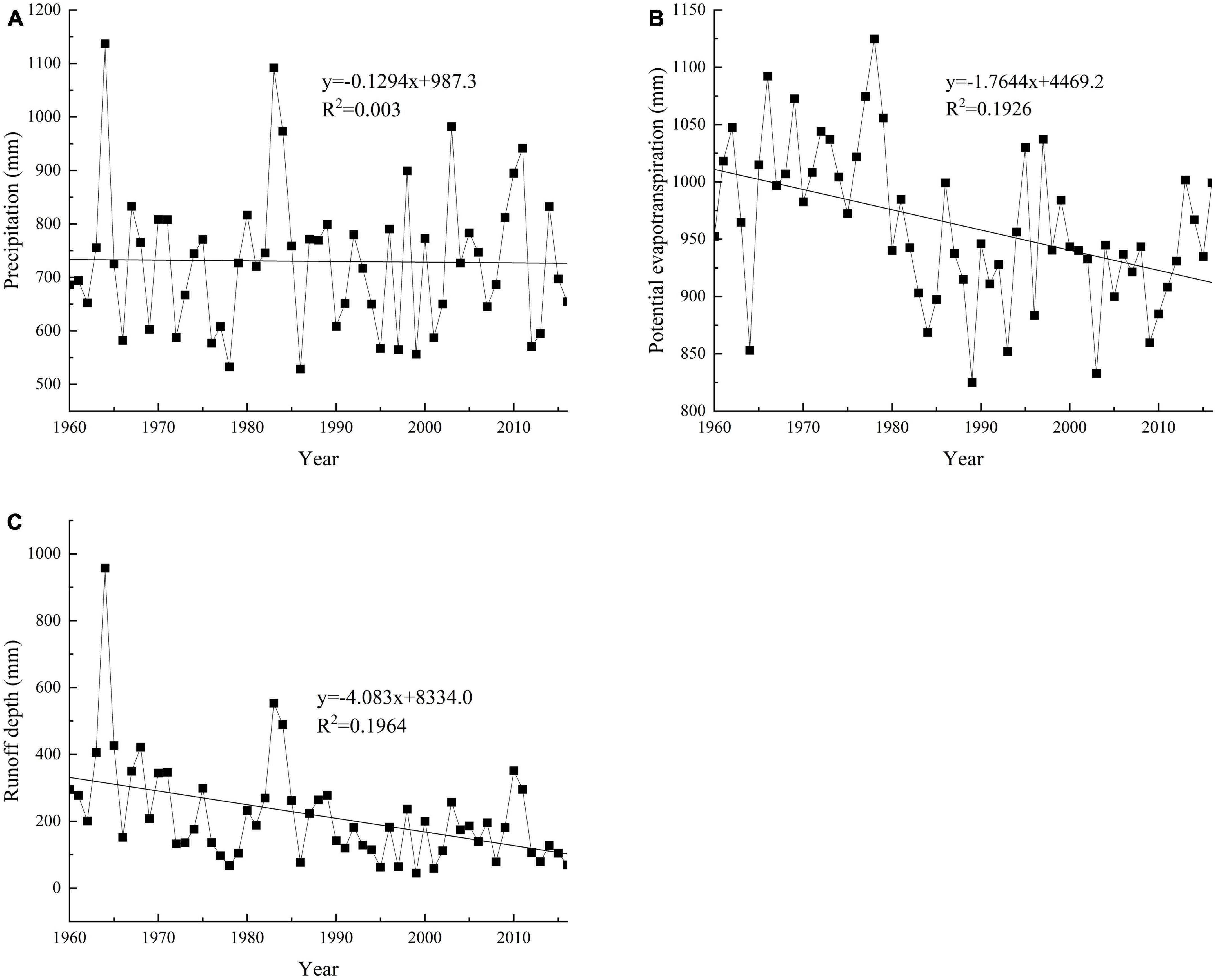
Figure 2. Statistical analysis of interannual variation of hydrometeorological elements in Danjiang River Basin: (A) precipitation, (B) potential evapotranspiration, (C) run off depth.
The identification of abrupt changes in runoff is achieved through the use of the AAC and M-K tests in the Danjiang River Basin. Figure 3 demonstrates that the runoff exhibited significant increases during 1960–1971 and 1981–1985, and significant decreases during 1972–1980 and 1989–2016. The M-K test is then employed to analyze the time series of the basin’s runoff from 1960 to 2016. The results of the test indicate that the runoff depth of the basin displayed a clear downward trend that surpassed the critical threshold of the significance level 0.05 between 1994 and 2016. The intersection analysis of UF (upper fluctuation) and UB (lower fluctuation) suggest that the mutation years of the long time series are 1975, 1982, and 1985. The combination of the results of the AAC and M-K test leads to the determination of the year of runoff mutation, which occurs in 1982.
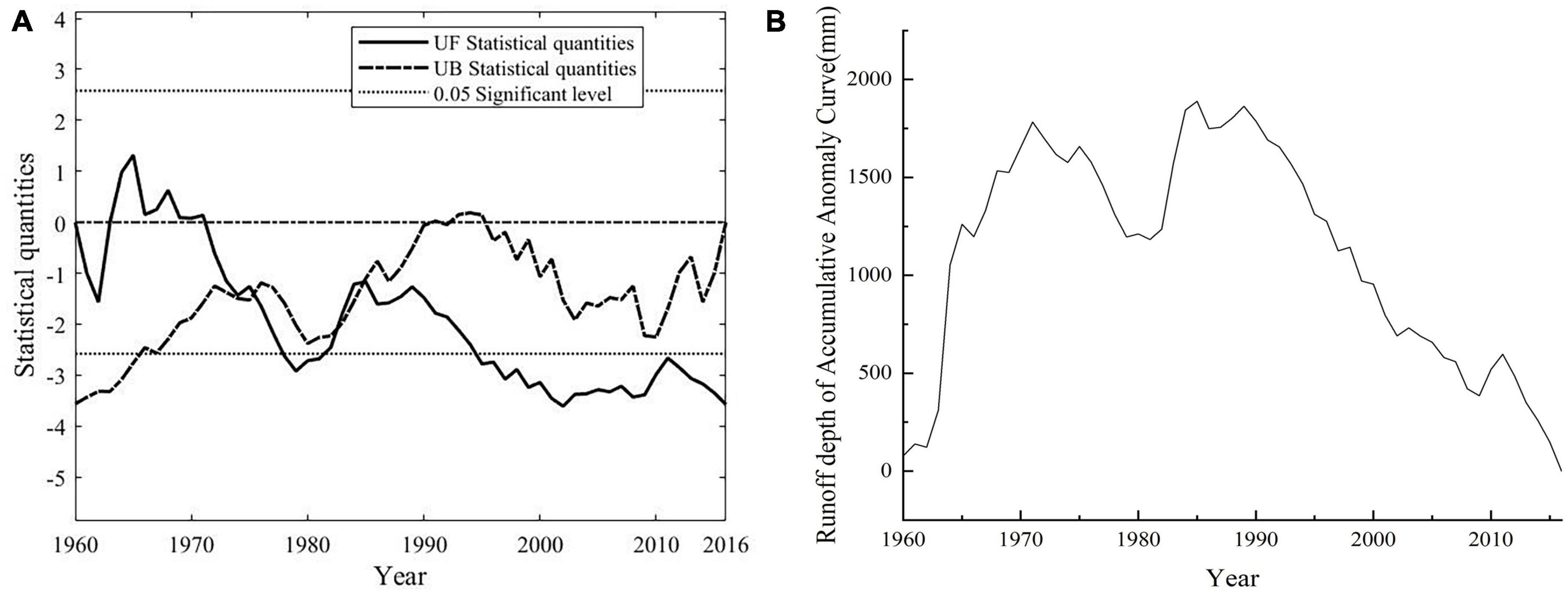
Figure 3. M-K test (A) and AAC (B) in the Danjiang River Basin during 1960–2016.
The available information suggests that significant changes have occurred in the hydrological elements of the Danjiang River Basin over the years (Table 2). The annual runoff depth has experienced a notable decline, while annual precipitation has shown a less pronounced downward trend. Although potential evapotranspiration has also decreased, the trend is not statistically significant. The application of the AAC and M-K tests facilitated the identification of abrupt change points in runoff, with the year 1982 being determined as the year of mutation. This event marks the division of the entire period into two parts: the base period (1960–1982) and the change period (1983–2016). Within the latter period, the mean annual precipitation and mean annual runoff depth decreased, while the mean annual evapotranspiration increased, and the drought index decreased.

Table 2. Characteristics of hydrometeorological elements in base period and change period.
The study also evaluates the Budyko-based methods by comparing the εp and εE0 values in the base period (1960–1982) and changing period (1983–2016) (Table 3). The value range of εp in the base period is 1.81–2.65, and the first four nonparametric Budyko-based methods is 2.45–2.65, the last four parametric Budyko-based methods in the base period is 1.79–1.84; The value range of εp in the changing period is 2.26–2.61, with the first four nonparametric Budyko-based methods is 2.31–2.61, and last four parametric Budyko-based methods is 2.26–2.43. The range of εE0 in the base period is −0.81–−1.65, with the first four nonparametric Budyko-based methods ranging from −1.45–−1.65 and the last four parametric Budyko-based methods ranging from −0.7−0.84. In the changing period, the range of εE0 is −1.26–−1.61, with the first four nonparametric Budyko-based methods ranging from −1.26–−1.61 and the last four parametric Budyko-based methods ranging from−1.26–−1.43. Comparison of εE0 values between the base period and the changing period show no significant differences in the eight Budyko-based methods, indicating that changes in E0 have little effect on the runoff changes in the basin.
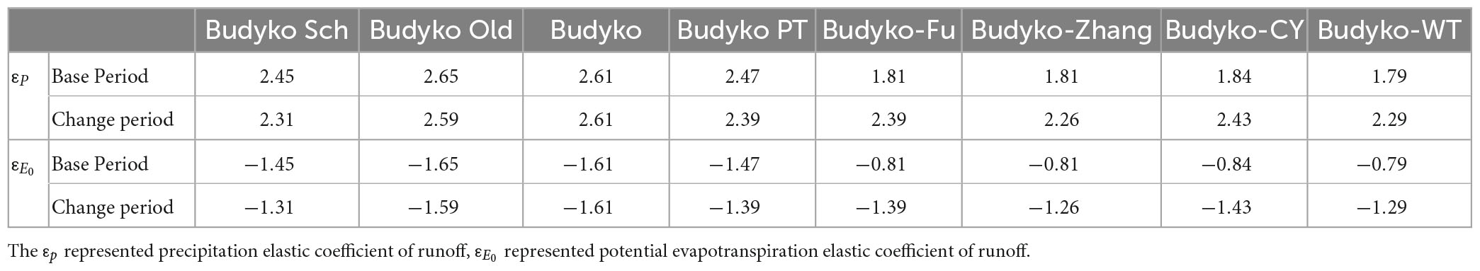
Table 3. The εp and εE0 of eight Budyko-based methods in base and change periods.
Based on our analysis, it can be deduced that precipitation (P) exhibits a significant positive correlation with runoff changes, while evapotranspiration (E0) displays a significant negative correlation with runoff changes in the Danjiang River Basin. The eight Budyko-based methods employed in this study have produced consistent outcomes with regards to the association between P, E0, and runoff changes, although the magnitudes of εE0 and εp have shown variability based on the specific approach employed. The implications of these findings are crucial for water resource management in the Danjiang River Basin and other similar regions, particularly in the context of climate change and its resulting variability.
Based on the data presented in the text, it is evident that the eight Budyko-based methods yield a range of values for the contribution of climate change to runoff change, spanning from −33.66 to −47.50% (Table 4). These results signify that climate change has been a restraining factor for the reduction of runoff in the Danjiang River Basin. In contrast, the contribution of anthropogenic activities to runoff changes ranged from 133.66 to 147.50%, indicating that human activities have been the primary driving force behind the reduction of runoff. The first four nonparametric methods yield Pc (climate change contribution) values ranging from −41.05 to −47.50%, while the Ph (anthropogenic contribution) values are between 141.05 and 147.50%. The Pc values for the last four parametric methods are −33.66 to −36.60%, and the Ph values range from 133.66 to 136.60%.
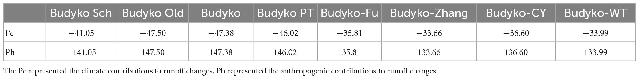
Table 4. Contributions of climate change and anthropological activities to runoff changes based on eight Budyko-based methods.
One possible explanation for the phenomenon observed in this study is the impact of anthropogenic activities on the hydrological processes and water balance of the watershed. Activities such as land use change and water resource utilization can significantly alter the water cycle. For instance, deforestation and urbanization can increase surface runoff and reduce infiltration, thus leading to changes in the water cycle. Similarly, dam construction and irrigation can directly affect the availability of water for runoff (Liao et al., 2018). These human activities can have a significant impact on runoff changes, and in some cases, their effect may outweigh that of climate change.
Normalized Difference Vegetation Index is a normalized index to measure the health of vegetation growth and could accurately describe the density of vegetation leaves. The increase of NDVI increases canopy interception and evapotranspiration of vegetation, and reduces watershed runoff (Lei et al., 2023). Therefore, this study analyses the NDVI of the Danjiang River Basin during the period of change. As shown in Figure 4, NDVI of the Danjiang River Basin shows an obvious upward trend during 1982–2016 (P < 0.05), with an increase rate of 0.0047/a, which peaks in the last year of the study period. This trend indicates that the Danjiang River Basin have a good vegetation cover, and also indicates that the runoff variation during the change period is affected by vegetation cover, which reduces the runoff of the basin. The observed increase in NDVI in the Danjiang River Basin aligns with previous research highlighting the crucial role of vegetation cover in regulating the hydrological cycle and mitigating runoff (Zhang et al., 2016). Various factors, including climate change, ecological restoration initiatives, and shifts in land use practices, may contribute to the rise in NDVI. However, further investigation is necessary to discern the underlying drivers of this trend and their implications for hydrological processes in the basin.
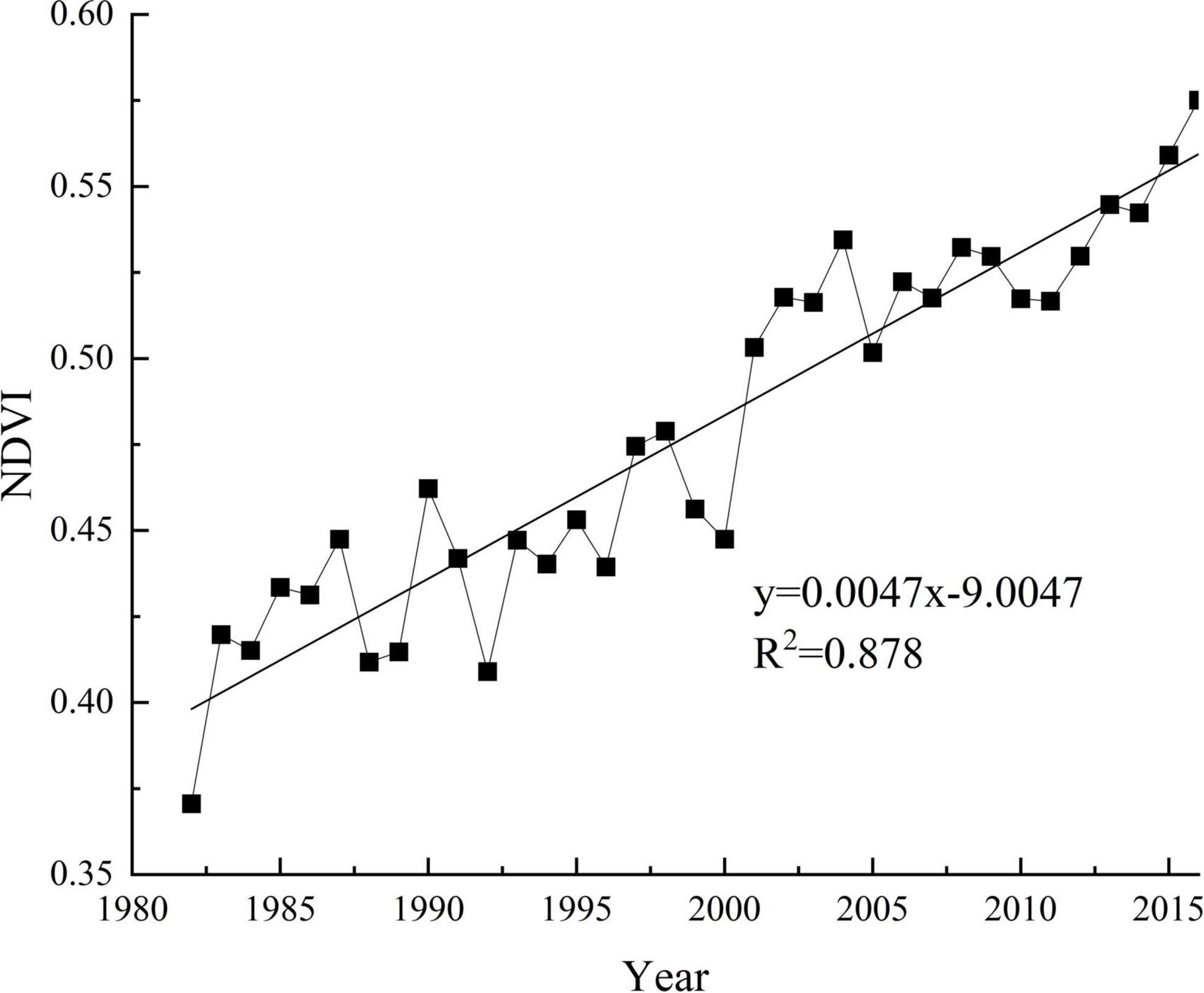
Figure 4. Variation trend of NDV in the Danjiang River Basin during 1982–2015.
The land use of the basin has also changed through the analysis of land use in Danjiang River Basin. It can be found from Table 5 that the land use is mainly arable land, grassland and forest, accounting for 95% of the total area. Forest and grassland are the most widely distributed, accounting for 76% of the total area, and there is a small amount of water and construction land. By comparing the land use ratio of the five periods from 1980 to 2015, it shows that the urban, rural, industrial, mining and residential land increase from 46.86 km2 in 1980 to 75.69 km2 in 2015, the construction land increases by 28.83 km2, and the land use of other types remained basically unchanged. This suggests that the expansion of urbanization and construction land has had a notable impact on the reduction of the basin’s runoff, as these land uses typically exhibit a lower infiltration rate and a higher surface runoff. Conversely, the rise in forest and grassland area may have played a part in the increase in NDVI and vegetation cover, ultimately resulting in a decrease in runoff. In sum, it is evident that land use changes have played a pivotal role in the reduction of runoff in the Danjiang River Basin.
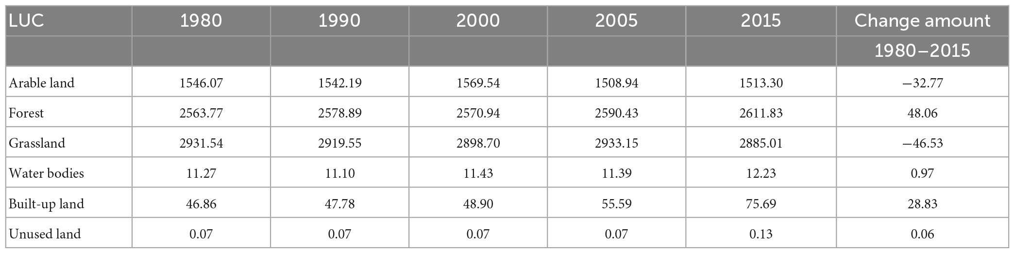
Table 5. Land cover change in the Danjiang River Basin during 1960–2016 (km2).
Based on the aforementioned analysis, it can be inferred that human activities, specifically land use change and the construction of hydraulic facilities, were the primary drivers of runoff reduction in the Danjiang River Basin during the period under investigation. Conversely, the impact of climate change on runoff reduction was found to be relatively minor. The increasing trend of NDVI in the basin suggests that vegetation cover played a role in reducing runoff. Nevertheless, it is important to acknowledge that this study did not fully investigate the influence of soil texture and landscape changes on runoff reduction, and thus, further research is warranted to comprehensively assess their contributions to runoff reduction in the basin.
This study employed the Budyko climate elasticity model to compare eight methods for quantitatively evaluating runoff in different periods of the Danjiang River Basin. The study aimed to examine the impacts of climate change and human activities on the runoff. Results showed that from 1960 to 2016, the basin exhibited a significant decreasing trend in runoff, with a rate of −4.083/a, while potential evapotranspiration showed a slight decreasing trend and precipitation remained stable. The study identified anthropogenic activities as the primary factor for the reduction in runoff, with a contribution rate in the range of 136.6 to 147.5%. Conversely, the contribution of climate change to the reduction in runoff ranged from −33.66 to −47.50%. The study concluded that while climate change hindered the reduction in runoff, anthropogenic activities contributed to it.
Publicly available datasets were analyzed in this study. This data can be found here: (http://data.cma.cn/ and http://www.gscloud.cn). (http://www.resdc.cn), Hydrological Data of the Yangtze River Basin, Hydrological Yearbook of the People’s Republic of China, The National Data Center for Earth System Science, Ministry of Science and Technology, China.
YH: conceptualization. YH and LZ: methodology. LZ: writing—original draft preparation and visualization. YH and WL: writing—review and editing. All authors have read and agreed to the published version of the manuscript.
This research was jointly supported by the Special Funds of the National Natural Science Foundation of China (Grant No. 42341102) and the National Science and Technology Basic Resource Investigation Program (Grant No. 2017FY100904).
The authors declare that the research was conducted in the absence of any commercial or financial relationships that could be construed as a potential conflict of interest.
All claims expressed in this article are solely those of the authors and do not necessarily represent those of their affiliated organizations, or those of the publisher, the editors and the reviewers. Any product that may be evaluated in this article, or claim that may be made by its manufacturer, is not guaranteed or endorsed by the publisher.
Brown, A. E., Zhang, L., and McMahon, T. A. (2005). A review of paired catchment studies for determining changes in water yield resulting from alterations in vegetation. J. Hydrol. 310, 28–61. doi: 10.1016/j.jhydrol.2004.12.010
Budyko, M. I. (1948). Evaporation under Natural Conditions, Gidrometeorizdat, Leningrad, English Translation by IPST, Jerusalem.
Ching, L., and Mukherjee, M. (2015). Managing the socio-ecology of very large rivers: Collective choice rules in IWRM narratives. Glob. Environ. Chang. 34, 172–184. doi: 10.1016/j.gloenvcha.2015.06.012
Choudhury, B. J. (1999). Evaluation of an empirical equation for annual evaporation using field observations and results from a biophysical model. J. Hydrol. 216, 99–110. doi: 10.1016/S0022-1694(98)00293-5
Fu, G. B., and Charles, S. P. (2007). A two-parameter climate elasticity of streamflow index to assess climate change effects on annual streamflow. Water. Resour. Res. 43, 1–12. doi: 10.1029/2007WR005890
Hang, Y. F., and Guan, D. X. (2011). Analysis of impacts of climate variability and human activity on streamflow for a river basin in northeast China. J. Hydrol. 410, 239–247. doi: 10.1016/j.jhydrol.2011.09.023
He, Y. F., Yang, D. W., and Tang, L. H. (2022). Attribution analysis of runoff change in the Bei Dasha River Basin. Water Resour. Protect. 38, 95–101.
He, Y., Qiu, H. J., and Song, J. X. (2019). Quantitative contribution of climate change and human activities to runoff changes in the Bahe River watershed of the Qingling Mountains, China. Sustain. Cities Soc. 51:101729. doi: 10.1016/j.scs.2019.101729
He, Y., Tian, P., and Mu, X. M. (2017). Changes in daily and monthly rainfall in the middle Yellow River. China. Thero. Appl. Climatol. 129, 139–148. doi: 10.1007/s00704-016-1763-4
He, Y., Wang, F., and Tian, P. (2016). Impact assessment of human activities on runoff and sediment of Beiluo river in the Yellow river based on paired years of similar Climate. Pol. J. Environ. Stud. 25, 121–135. doi: 10.15244/pjoes/60492
Jiang, X. M., Wang, G. Q., and Xue, B. L. (2022). Spatiotemporal variations and driving forces of actual evapotranspiration in Hunhe river basin based on Budyko theory and complementary model. Chinese J. Ecol. 41, 1361–1368.
Lei, Q., Hu, Z. W., and Wang, J. Z. (2023). Spatiotemporal dynamics of NDVI in China from 1985 to 2015: Ecosystem variation, regional differences, and response to climatic factors. Acta Ecol. Sin. 43, 1–14.
Li, X. G., Xue, W., and Zhu, M. (2018). Evaluation and regulation of river health based on analytic hierarchy process in Danjiang river basin. J. Shangluo Univ. 32, 44–49+54.
Li, Z., Liu, W. Z., and Zhang, X. C. (2009). Impacts of land use change andclimate variability on hydrology in an agricultural catchment on the Loess Plateau of China. J. Hydrol. 377, 35–42. doi: 10.1016/j.jhydrol.2009.08.007
Liao, W. T., Deng, H. B., and Li, R. N. (2018). Effects of dams on runoff in the lower reaches: A case study of the Gezhouba hydro-project and the Three Gorges project. Acta Ecol. Sin. 38, 1750–1757. doi: 10.5846/stxb201704070596
Liu, S. Y., Deng, W. P., and Ouyang, L. (2018). A quantitative study of impacts of rainfall and vegetation changes on runoff in Pengchongjian small watershed. Acta. Agr. Uni. JX. 40, 189–197.
Liu, X. M., and Zhang, D. (2013). Spatial and temporal changes in aridity index in northwest China: 1960 to 2010. Thero. Appl. Climatol. 112, 307–316. doi: 10.1007/s00704-012-0734-7
Lou, S. J., Mo, L., and Wang, Y. Q. (2019). Trend analysis of monthly and annual runoff based on a segmented M-K method in Fuhe River Basin, China. IOP Conf. Series Earth Environ. Sci. 344:012108. doi: 10.1088/1755-1315/344/1/012108
Mann, H. B. (1945). Non-parametric test against trend. Econometrika 13, 245–259. doi: 10.2307/1907187
Miao, C. Y., Kong, D. X., and Wu, J. W. (2016). Functional degradation of the water-sediment regulation scheme in the lower Yellow River: Spatial and temporal analyses. Sci. Total Environ. 55, 16–22. doi: 10.1016/j.scitotenv.2016.02.006
Ol’dekop, E. M. (1911). On Evaporation from the Surface of River Basins: Transactions on Meteorological Observations, Lur-Evskogo Report. Tartu: University of Tartu.
Pike, J. G. (1964). The estimation of annual run-off from meteorological data in a tropical climate. J. Hydrol. 2, 116–123. doi: 10.1016/0022-1694(64)90022-8
Qing, L. H., Zhou, J. X., and Li, X. Y. (2018). Attribution analysis of changes in runoff in the upstream of the Mayon Reservoir. Acta Ecol. Sonica 38, 1941–1951. doi: 10.5846/stxb201609301980
Schreiber, P. (1904). Uber die Beziehungen zwischen dem Niederschlag und der Wasserfu “hrung der Flu” ße in Mitteleuropa. Me-teorologische Zeitschrift. 21, 441–452.
Wang, D. B., and Tang, Y. (2014). A one-parameter Budyko model for water balance captures emergent behavior in Darwinian hydrologic models. GRE 41, 4569–4577. doi: 10.1002/2014GL060509
Wang, G. Q., Zhang, J. Y., and Bao, Z. X. (2019). Change in runoff within the Lan River Basin due to climate change and human activities. J. Irrig. Drain. Eeg. 38, 113–118.
Wu, J. W., and Miao, C. Y. (2017). Contribution analysis of the long-term changes in seasonal runoff on the Loess Plateau, China, using eight Budyko-based methods. J. Hydrol. 545, 263–275. doi: 10.1016/j.jhydrol.2016.12.050
Xu, C. Y. (1999). Climate change and hydrologic models: A review of existing gaps and recent research developments. Water Resour. Manag. 13, 369–382. doi: 10.1023/A:1008190900459
Xu, J. X., Ding, W. F., and Lin, Q. M. (2019). Characteristics analysis of runoff and sediment variation in Danjiang River Watershed. Resour. Environ. Yangtze Basin 28, 1956–1964.
Yang, D. W., Yang, Y. T., and Gao, G. Y. (2021). Water cycle and soil-water coupling processes in the Yellow river basin. Bull. Natil. Nat. Sci. Found. China 35, 544–551.
Zhang, J., Jia, C. R., and Li, P. (2016). NDVI spatial distribution and its correlation with land-use in DanRiver Watershed of Shaanxi Province. Sci. Soil Water Conserv. 14, 67–73.
Zhang, L., and Dawes, W. R. (2001). Response of mean annual evapotranspiration to vegetation changes at catchment scale. Water Resour. Res. 37, 701–708. doi: 10.1029/2000WR900325
Zhao, C. Y., Wang, Y. X., and Wen, Z. Z. (2017). Analysis of runoff variation and influencing factors in Pigling reach of Jing he river. J. Water Resour. Water Eng. 28, 36–41.
Keywords: Danjiang River Basin, Budyko hypothesis, climate change, anthropogenic activities, runoff changes
Citation: Zhao L, He Y and Liu W (2023) Attribution of runoff changes in the Danjiang River Basin in the Qinba Mountains, China. Front. For. Glob. Change 6:1187515. doi: 10.3389/ffgc.2023.1187515
Received: 16 March 2023; Accepted: 02 May 2023;
Published: 18 May 2023.
Edited by:
Licong Dai, Hainan University, ChinaReviewed by:
Baisha Weng, China Institute of Water Resources and Hydropower Research, ChinaCopyright © 2023 Zhao, He and Liu. This is an open-access article distributed under the terms of the Creative Commons Attribution License (CC BY). The use, distribution or reproduction in other forums is permitted, provided the original author(s) and the copyright owner(s) are credited and that the original publication in this journal is cited, in accordance with accepted academic practice. No use, distribution or reproduction is permitted which does not comply with these terms.
*Correspondence: Ye Hi, eWloZUBud3UuZWR1LmNu; Wanqing Liu, bGl1d3FpbmdAbnd1LmVkdS5jbg==
Disclaimer: All claims expressed in this article are solely those of the authors and do not necessarily represent those of their affiliated organizations, or those of the publisher, the editors and the reviewers. Any product that may be evaluated in this article or claim that may be made by its manufacturer is not guaranteed or endorsed by the publisher.
Research integrity at Frontiers
Learn more about the work of our research integrity team to safeguard the quality of each article we publish.