 Christoph Parsch1*†
 Benjamin Wagner2*†
 Margaretha Pangau-Adam3,4
 Craig Nitschke2
 Holger Kreft1,5
 Julian Schrader1,6
- 1Biodiversity, Macroecology and Biogeography, University of Göttingen, Göttingen, Germany
- 2Faculty of Science, School of Ecosystem and Forest Sciences, The University of Melbourne, Richmond, VIC, Australia
- 3Department of Conservation Biology, University of Göttingen, Göttingen, Germany
- 4Biology Department, Faculty of Natural Sciences and Mathematics, Cenderawasih University, UNCEN Waena Campus, Jayapura, Indonesia
- 5Centre of Biodiversity and Sustainable Land Use (CBL), University of Göttingen, Göttingen, Germany
- 6School of Natural Sciences, Macquarie University, Sydney, NSW, Australia
Land-use change has progressed rapidly throughout the Indonesian archipelago and is now intruding into western New Guinea (Tanah Papua), one of the world’s last wilderness areas with extensive tracts of pristine and highly diverse tropical rainforests. Tanah Papua has reached a crossroads between accelerating environmental degradation and sustainable development policies entailing landscape-scale conservation targets, pledged in the Manokwari Declaration. We assessed the representation of ecoregions and elevational zones within Tanah Papua’s protected area network to identify its shortcomings at broad spatial scales. Lowland ecoregions are less protected than mountainous regions, with half of the western and southern lowlands designated for land-use concessions. Under the direct threat from land-use change, the political motivation in Tanah Papua toward conservation- and culture-centered land management provides a window of opportunity for scientifically guided, proactive conservation planning that integrates sustainable development for the benefit of Indigenous communities.
Introduction
Southeast Asia is rich in biodiversity, but also a region of great conservation concern (Wilcove et al., 2013). In Indonesia in particular, land-use change and environmental degradation are progressing rapidly, leading to immense losses of forest cover, totaling ∼98,000 km2 (11% of Indonesia’s forest area) between 2001 and 2019 alone (Hansen et al., 2013; Gaveau et al., 2021b). While these processes are well advanced throughout most of Indonesia, its two easternmost provinces—Papua and Papua Barat on the island of New Guinea (hereinafter referred to as Tanah Papua—land of Papua)—still maintain a substantial amount of primary forests (83% of its ∼411,000 km2 land area). Therefore, Tanah Papua represents one of the largest remaining rainforest areas in the world. Nevertheless, land-use change and associated deforestation are also increasing, as Tanah Papua has emerged as a new frontier for economic development (Austin et al., 2017; Sloan et al., 2019). A complex network of land-use concessions facilitated by considerable infrastructure developments threatens vast areas of Tanah Papua’s diverse terrestrial ecosystems with conversion to oil palm or tree plantations and logging areas (Global Forest Watch, 2019; UNEP-WCMC and IUCN, 2019; Figure 1). However, the extent of many concessions is still subject to consolidation and legal disputes, with patchy and non-transparent availability to the public (Jong, 2021a). With the prospect of progressing forest loss, local aspirations for sustainable development in Tanah Papua were recently formulated in the Manokwari Declaration.
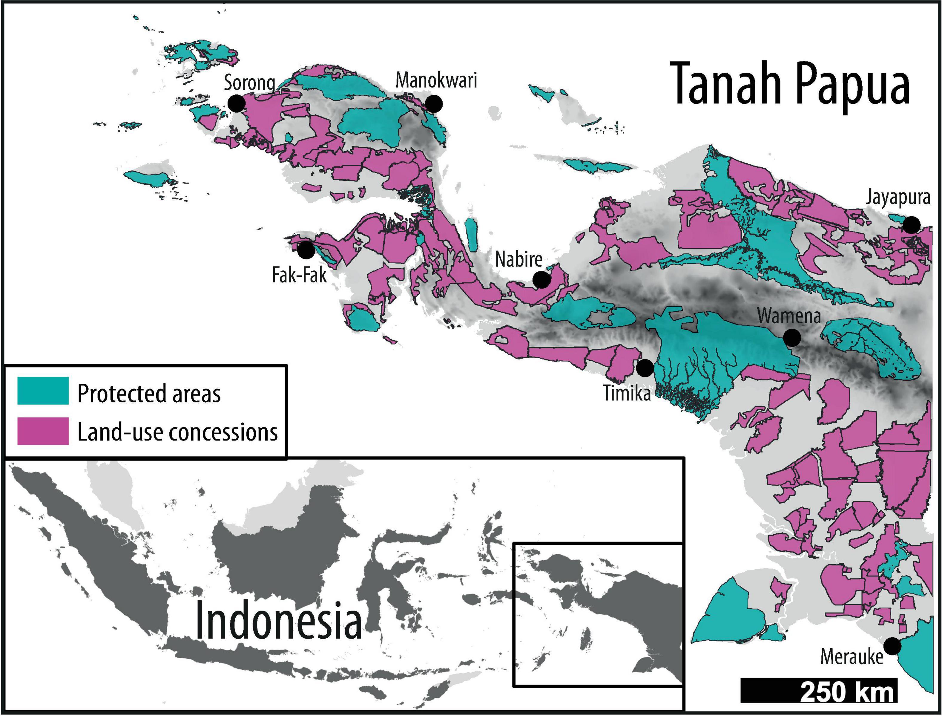
Figure 1. Tanah Papua, Indonesia with protected areas (UNEP-WCMC and IUCN, 2019) and publicly available land-use concessions (Global Forest Watch, 2019). Topography is illustrated in light gray (lowest elevation) to black (highest elevation at c. 4,900 m). Protected areas represent 20% of the study area, while assessed land-use concessions comprise 29%.”
This Memorandum of Understanding, signed by the governors of Papua and Papua Barat in 2018 aims to protect > 70% of Tanah Papua’s land area and ensure sustainable development for the benefit of Indigenous communities (Manokwari Declaration, 2018; Cámara-Leret et al., 2019b). Within this political context, the Indonesian social forestry permit scheme will play a key role in facilitating sustainable development in the region, while providing legal access to land for local communities (Fatem, 2019). The ability for social forestry to provide the desired benefits to local communities and biodiversity, will strongly depend, however, on the context and type of social forestry practices permitted (Meijaard et al., 2020; Sahide et al., 2020). Considering the ambitious conservation targets and progressing land-use change in the region, spatial allocation of conservation efforts and social forestry permits is gaining importance. Here, we outline the current state of biodiversity protection in Tanah Papua in the context of the Manokwari Declaration and discuss recent land-use changes and environmental trends. We assess the current distribution of protected areas and corresponding political developments, identify research needs and discuss systematic conservation planning approaches that have the potential to shape the future policy discourse in Tanah Papua.
Land-Use Change in Tanah Papua
Indonesia exhibits one of the highest deforestation rates worldwide, averaging 5,100 km2 per annum between 2001 and 2019 (Hansen et al., 2013; Gaveau et al., 2021b). The main drivers of deforestation include logging, expansion of oil palm (Elaeis guineensis), pulp and paper plantations, aquaculture, road construction, mining, and fires (Austin et al., 2019). The importance and spatio-temporal dynamics of these drivers vary among regions (Austin et al., 2019). Since 2016, decreasing deforestation rates were recorded Indonesia-wide, which were linked to decreasing crude palm oil prices and, subsequently, reduced oil palm expansion (Gaveau et al., 2021a). Nevertheless, absolute forest loss remains high nation-wide and increasing global demand for palm oil may facilitate future increases in forest loss (Gaveau et al., 2021a).
Tanah Papua contains ∼343,000 km2 of forest equal to 83% of its landmass and 42% of Indonesia’s remaining forest area (Gaveau et al., 2021b). Although its global importance for biodiversity and rainforest conservation is widely recognized (Brooks et al., 2006), oil palm-associated deforestation in Tanah Papua increased fivefold between 2010 and 2015, with two thirds of newly established oil palm plantations occurring at the expense of tropical forests (Austin et al., 2017). Over the last decade, the region has experienced a shift from small-scale clearings for timber harvesting and agriculture, to a large-scale plantation economy as the dominant driver of deforestation (Austin et al., 2019). Although forest conversion rates in Tanah Papua are much lower compared to other parts of Indonesia, considerable infrastructure developments in the region are paving the way for accelerated land conversion (Sloan et al., 2019; Gaveau et al., 2021b). National development agendas and infrastructure projects, such as the Papua mega-highway project, aiming to establish more than 4,000 km of roads, or the Merauke Integrated Food and Energy Estate, increase accessibility to remote forested areas (Sloan et al., 2019). Such megaprojects are known to entail social and ecological impacts and exacerbate challenges for conservation in Indonesia (Sloan et al., 2019; Laurance et al., 2020). While road access may benefit local communities, increasing accessibility facilitates the development of remote and previously inactive concessions and reinforce concerns of ecological impunity in the region (Ahmed and Cann, 2021). The extent of publicly available land-use concessions comprises oil palm or tree plantations and logging areas, which currently cover over 133,400 km2 (∼29%) of Tanah Papua (Figures 1, 2A). Data for mining concessions is not publicly available. Overall, the actual extent and allocation of land-use concessions is non-transparent and often conflicting.
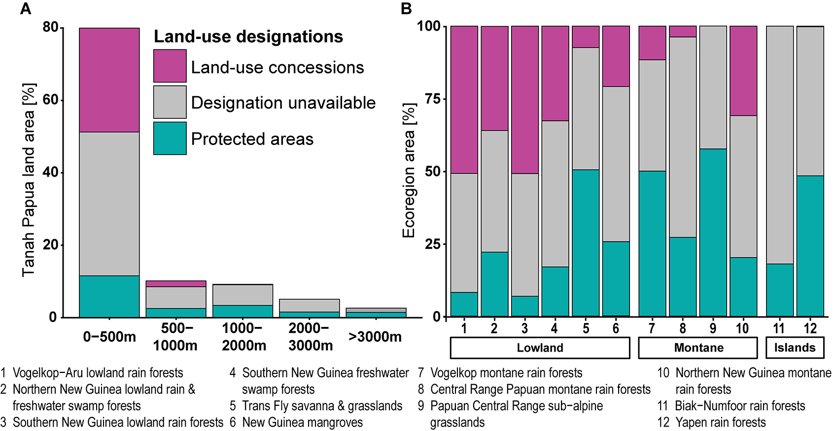
Figure 2. Representation of land-use concessions and protected areas in Tanah Papua for (A) elevation and (B) existing ecoregions (Dinerstein et al., 2017). See Supplementary Figure 1 for a map of Tanah Papua’s ecoregions adapted from Dinerstein et al. (2017).
The Manokwari Declaration
The Manokwari Declaration constitutes a Memorandum of Understanding signed by the governors of Papua and Papua Barat at the International Conference on Biodiversity, Ecotourism and Creative Economy in 2018. The Memorandum of Understanding formulates a common vision for Tanah Papua’s future “Tanah Papua Damai, Berkelanjutan, Lestari, dan Bermartabat” or “the land of Papua that is peaceful (socio-economically) sustainable (culturally and naturally) enduring, and dignified.” The Manokwari Declaration advocates for placing remarkable >70% (∼300,000 km2) of Tanah Papua’s land area under conservation protection, while simultaneously integrating customary rights to promote sustainable development and meet the aspirations of all Papuans (Manokwari Declaration, 2018). A central aspect of these conservation commitments is to facilitate local economic development agendas and Indigenous needs, rather than strict preservation per se. The Manokwari Declaration further includes a moratorium on permits for large-scale land-use concessions and calls for a fundamental review and restructuring of already issued concessions. The province of Papua Barat recently concluded a review of the existing palm oil concessions, in which the data and extent of the respective concessions were consolidated, leading to a seizure of ∼276,000 ha from 12 oil palm concessions due to administrative and legal violations (Jong, 2021b). Such efforts represent important steps toward the pledges of the Manokwari Declaration, while balancing the need to meet new national regulations that permit the conversion of protected forests to agriculture lands, to increase national food security (MoEF, 2020). The momentum of the Manokwari Declaration was further reinforced by the Special Regional Regulation (Perdasus) No. 10 of 2019 on sustainable development plans, which makes Papua Barat Indonesia’s first “conservation province,” as well as Perdasus No. 11/2019 on the customary rights of Indigenous people. The main outcomes of these policy developments was the placement of conservation, customary land rights, and sustainable development at the center of economic activities and development (Conservation International, 2019; Fatem, 2019). The Government of Papua province has also set the basis for conservation initiatives in regulations such as Perdasus No. 21/2008 on Sustainable Forest Management and 23/2008 on Customary Rights of Indigenous People and Individual Rights for Land. Providing Indigenous communities with access to land and encouraging bottom-up initiatives, such as community-based natural resource management through social forestry permits are of particular importance for realizing the vision of the Manokwari Declaration (Fatem, 2019). However, funding may represent a major barrier to implementing sustainable development and conservation aspirations and the effectiveness of formal protection measures.
Social Forestry in Tanah Papua
The Indonesian social forestry program encompasses five main permit types: (i) village forest (Hutan Desa), (ii) community-based forestry (Hutan Kemasyarakatan), (iii) community-based timber plantation (Hutan Tanaman Rakyat), (iv) customary forest (Hutan Adat), and (v) forestry partnership land (Kemitraan Kehutanan), which provide rural communities with access to forest resources. Siscawati et al. (2017) provide a detailed summary of the history, aims, and involved institutions of these different permit types. Indonesia has seen a succession of new forest policies over the last decades, however, former policies have rarely been adapted or annulled, resulting in a layering of policies, which can compromise regulation and enforcement of new policies (Erbaugh and Nurrochmat, 2019). While the Indonesian social forestry program aims at reducing poverty and deforestation by transferring rights to land and forest management responsibilities to Indigenous communities, it could further increase policy layering. The underlying paradigm shift from centralized, top-down forest management, toward decentralized responsibilities intends to foster empowerment and recognition of Indigenous communities (Erbaugh and Nurrochmat, 2019; Fisher et al., 2019). The social forestry program experienced a rapid expansion through the number of permits since 2012. But assessments of the social, cultural, and environmental impacts of operating social forestry permits are scarce and often biased toward western Indonesia (see e.g., Fisher et al., 2019; Meijaard et al., 2020; Rakatama and Pandit, 2020). While existing case studies indicate positive effects of social forestry permits regarding social and environmental benefits, their findings are dependent on sociocultural and biophysical contexts and their comparability is limited (Santika et al., 2019; Meijaard et al., 2020). Moreover, most studies have focused on social and economic perspectives rather than environmental impacts of established social forestry permits (Rakatama and Pandit, 2020). With regard to its rapid expansion, the social forestry program has also been criticized for its focus on the allocation of permits rather than their implementation, capacity building, and monitoring (Erbaugh and Nurrochmat, 2019; Fisher et al., 2019; Meijaard et al., 2020). Concerns include inequalities of beneficiaries and exclusion of forest users, intensified land tenure conflicts, and increased operation of commercial logging companies on customary land (Myers et al., 2017; Sloan et al., 2019; Sahide et al., 2020). To strengthen formal land planning decisions, endorsement by local stakeholders such as customary forest owners is crucial for the effectiveness of a land-use designation. Observations from the designation of the Lorentz National Park as a UNESCO World Heritage Site illustrate that if local landowners are indifferent toward new land designations, these regulations are likely to be ignored (Sloan et al., 2019). Social forestry, on the other hand, provides opportunities to include the needs and aspirations of local stakeholders, increasing the chance for support. Moreover, the benefits of social forestry permits for conserving biodiversity and forest area may still outweigh the negative impacts, if the alternatives result in the eviction of communities for the establishment of industrial-scale plantation operations. Nevertheless, considering the large scale (>70% of Tanah Papua’s land area) at which social forestry is foreseen to provide Indigenous communities access to land in the context of the Manokwari Declaration in Tanah Papua, central questions regarding bureaucratic procedures, extent of local participation, socioeconomic implications, and environmental impacts remain unresolved (Fatem, 2019; Fisher et al., 2019).
Community-based natural resource management in Tanah Papua has the potential to protect large areas, because land is a common asset in many local communities (Sheil et al., 2015). However, traditional resource management practices may differ from the objectives of governmentally issued social forestry permits (Fatem, 2019; Sahide et al., 2020). Social and environmental impacts of the current policy developments should be assessed to understand implications of the implementation process and adaptively manage future social forestry development. Furthermore, the processes of permit issuing and spatial allocation should become more transparent and structured to increase accessibility for local communities (Myers et al., 2017). Customary land claims as well as social forestry permits can overlap with existing land-use designations, and the resulting community rights, benefits, and challenges vary by land-use. Therefore, standardized impact evaluations of community forest management that adaptively monitor and evaluate sociocultural and environmental impacts of permits should be fostered (Meijaard et al., 2020). Competing land claims, a lack of synchronization in concession planning by different governmental agencies, and a complex fragmentation of forest governance responsibilities between the central- and provincial governments, likely complicate the progress of land-use planning and sustainable development policies in Tanah Papua (Fatem, 2019; Sloan et al., 2019).
Land-Use Planning
While forest loss and fragmentation are not yet advanced in Tanah Papua, developments in other parts of Indonesia have demonstrated how rapidly large, forested areas can be converted to agricultural lands (Laumonier et al., 2010; Austin et al., 2017). In the light of progressing economic development in the region, spatial planning, which considers landscape fragmentation, composition, and connectivity, will become increasingly important to reconcile aspirations of economic development and biodiversity conservation. In this context, the Manokwari Declaration represents a window of opportunity to developing biodiversity-friendly landscapes for the benefit of humans and nature. However, designing such landscapes is challenging (Arroyo-Rodriguez et al., 2020), and systematic conservation planning depends on a strong data foundation, such as comprehensive biodiversity data (Kujala et al., 2018). Biological surveys, however, have been scarce in Tanah Papua (Marshall and Beehler, 2007; Hughes et al., 2021) and in the absence of sufficient species-level data, ecoregional classifications (Supplementary Figure 1) or elevational zones may serve as useful proxies to support nature conservation at broad scales (Dinerstein et al., 2017; Smith et al., 2020). These metrics capture characteristics in climate, landform, and soil, which shape patterns of biodiversity at coarse scales (Turner and Gardner, 2015). As a first step toward more comprehensive systematic conservation planning, we analyzed the extent of protected areas and current land-use concessions in Tanah-Papua (for detailed methods see Supplementary Information). We found that publicly available land-use concessions for oil palm or tree plantations and logging areas covered ∼138,000 km2 (29% of total land area), while Tanah Papua’s protected area network currently covers ∼92,000 km2 (∼20%) (Figures 1, 2A; UNEP-WCMC and IUCN, 2019). The actual extent, however, might vary considerably due to inconsistent data availability for land-use concessions. Lowland ecoregions are less protected than remote mountainous areas. For example, two ecoregions of similar size, the Central Range Papuan Montane Rainforests and Southern New Guinea Lowland Rainforests were ∼27 and 7% protected, respectively (Figure 2A and Supplementary Tables 1, 2). Furthermore, most ecoregions that are currently less than one quarter under protection were located in the lowlands. The same pattern emerged for ecoregions that have >25% of their area designated to land-use concessions (Figure 2B). The ecoregions with the highest overlap with concessions (>50%) were in the west (Vogelkop-Aru Lowland Rainforest) and south, respectively (Southern New Guinea Lowland Rainforest). These two ecoregions cover ∼22% of Tanah Papua’s total land area and account for a major proportion of land-use concessions (57% of total concession area, Supplementary Table 2). Overall, we identified a geographical bias in the protected area network toward high elevations (Figure 2), while land conversion is primarily projected for the lowlands (Gaveau et al., 2021b). These findings for Tanah Papua are consistent with the biased global distribution of protected areas (Joppa and Pfaff, 2009). Still, some of the existing protected areas are threatened due to conflicts with road development projects or conversion to food estates (Sloan et al., 2019; MoEF, 2020). As ecoregions characterize geographic locations based on the homogeneity of their environmental and biodiversity features, negative trends in ecoregion intactness in Tanah Papua may indicate adverse environmental impacts on ecosystems and their associated functioning and biodiversity in the region (Beyer et al., 2019).
Elevational gradients represent strong proxies for plant endemism globally (Steinbauer et al., 2016), and for vertebrate species richness in New Guinea (Tallowin et al., 2017). These gradients represent species turnover within landscapes and ecoregions and the representative protection of ecosystems along elevational gradients is an important coarse-filter approach to conserving biodiversity in New Guinea (Cámara-Leret et al., 2020). Endemism is higher and range sizes of plants and animals smaller in mountainous regions compared to lowland regions (Jetz and Rahbek, 2002; Grenyer et al., 2006), which may justify a lower relative representation in Tanah Papua’s lowland forests. However, because elevational gradients are a significant predictor for plant and vertebrate richness throughout New Guinea (Tallowin et al., 2017; Cámara-Leret et al., 2020), their balanced representation should be vital for conservation planning. While mountainous ecoregions appear to be covered by protected areas to a great extent, Tanah Papua’s lowlands are more accessible, have higher potential for agricultural expansion and fragmentation of forests (Delzeit et al., 2017), and thus are at greater risk of degradation. Recent studies found that the spatial distribution of emerging environmental threats, such as climate change (Cámara-Leret et al., 2019a) and forest degradation along development frontiers (Sloan et al., 2019; Gaveau et al., 2021b), may have severe impacts on local communities and Tanah Papua’s unique biodiversity alike. As such, future assessments of conservation priorities at finer scales are needed to mitigate biodiversity loss in the face of potential land-use change. Future spatial planning in the region should proactively address emerging deforestation threats, integrate the objectives of Indigenous communities, and maintain landscape connectivity, while still possible throughout Tanah Papua’s diverse terrestrial ecosystems.
Conservation planning in the region will require the application of spatial conservation planning approaches that can balance the need to prioritize the protection and representativeness of the region’s biodiversity with determining how best to manage within and outside of these conservation areas. There are many conservation planning approaches, such as multi-objective prioritization (Strassburg et al., 2019; Venier et al., 2021), which explores spatial and economic trade-offs of different management and conservation scenarios. Integrated landscape approaches represent governance strategies that engage multiple stakeholders to identify trade-offs and synergies in sustainable development with the objective of balancing social and environmental objectives (Reed et al., 2020). Integrated landscape approaches can also provide valuable aspects for social-political engagement and set out a process of best-practice for landscape-level planning (Reed et al., 2020). Approaches based on multi-objective prioritization and governance strategies tend to focus on the threats, actions, and costs to conservation, while spatial action mapping aims to explicitly consider the uncertainty of the impacts and interventions through an adaptative planning framework (Tallis et al., 2021). Spatial action mapping provides valuable options for incorporating spatial and multiple objective prioritizations with participatory planning (Tallis et al., 2021). However, there are many approaches that can be used to facilitate conservation planning in Tanah Papua. These approaches have the potential to shape and direct the future policy discourse on how objectives of conservation, local livelihoods, and agricultural production can be achieved in Tanah Papua. These approaches allow conservation boundaries to be demarcated and adjusted while management strategies are developed, implemented, and refined. However, the risk of decision complacency “the non-use of evidence or systematic processes to make decisions” may neglect results of the most sophisticated systematic conservation planning approaches and thus hinder conservation in the region (Gardner et al., 2018).
Discussion
While Tanah Papua faces progressing environmental degradation, sustainable development policies entailing landscape-scale conservation targets, as pledged in the Manokwari Declaration, are emerging. We showed that strong biases exist in the allocation of land designations at broad scales by pointing out regions with low protection that overlap with areas of emerging threats to biodiversity. To implement the ambitious goals of the Manokwari Declaration and to mitigate negative effects of the looming land-use changes in Tanah Papua, urgent action is required. We argue that within the current political context, this can only be reached by holistically: (i) promoting social forestry, (ii) including aspirations of Indigenous communities; and, (iii) systematic conservation planning.
The social forestry program, despite concerns about the modus operandi, and its capacities to provide the desired benefits for local communities and the environment, was singled out by the provinces of Papua and Papua Barat to realize their aspirations expressed in the Manokwari Declaration (Fatem, 2019; Sahide et al., 2020). However, implementation in its current form may need improvements to ensure equity of access to the social forestry program, among and within local communities. Improved capacity building is required to aid in the application for and implementation of permits (Myers et al., 2017).
Interests and values of Indigenous communities need to be included in the process of establishing and implementing social forestry permits to acknowledge their land claims and capture their aspirations throughout the process, analogous to a global call for better inclusion of Indigenous custodians into conservation and planning (Garnett et al., 2018). Conventional top-down planning and management approaches typically do not focus on concerns of Indigenous communities (Wollenberg et al., 2009). Participatory approaches to mapping traditional land-use and tenure in Indonesia are still isolated cases and a transfer of such into spatial planning regulations remains limited. Sulistyawan et al. (2018) provide an encouraging example from Merauke district, Papua, of how local knowledge can affect spatial planning regulations on a small scale. Whether and how such approaches can be applied across Tanah Papua should be subject of future interdisciplinary research in the region. Considering the progressing land degradation, time is pressing to scale up such participatory approaches proactively, rather than reactively mapping remaining forests for local communities after large scale concession developments have already occurred.
Systematic conservation planning approaches should be implemented and include participatory planning outputs from the community level. This may facilitate designing a wider biodiversity-friendly landscape that promotes biodiversity conservation along with improvements in local people’s livelihoods. A key requirement for conservation planning to be successful is the acknowledgment that Indigenous peoples in the region have managed and shaped its ecosystems and biodiversity for millennia and that traditional practices within a conservation network may foster biodiversity conservation (Fletcher et al., 2021). Such an approach has the potential to safeguard regional conservation priorities by reducing rapid land-use change while maintaining local livelihoods.
To move toward evidence-based conservation planning, the environmental impacts of the various social forestry schemes in Tanah Papua need to be assessed by rigorous, transparent, and independent monitoring. Future conservation-centered research in Tanah Papua should further aim at identifying synergies between prosperity aspirations of local communities and regional conservation priorities, to maximize benefits for people and biodiversity. This knowledge will provide important information for reducing uncertainties in the application of land-use planning tools (Tallis et al., 2021). Pathways of participation for Indigenous communities in spatial planning should be developed to capture and support the needs and rights of local communities throughout the development process. However, the reconciliation of development and conservation objectives could be severely affected by unresolved conflicts of land ownership in the region, inconsistent availability of spatial data, and decision complacency (Gardner et al., 2018; Fatem, 2019; Sloan et al., 2019; Gaveau et al., 2021b). Tanah Papua has reached a crossroads between accelerating environmental degradation and sustainable development policies entailing landscape-scale conservation actions. The Manokwari Declaration opens a unique window of opportunity to develop a systematic conservation planning scheme, capable of mitigating future biodiversity loss in Tanah Papua, while strengthening rights and land-titles of Indigenous people. Time is pressing for governance actions envisioned in the Manokwari Declaration to be realized. We argue that representation of terrestrial ecosystems in the form of ecoregions and elevational gradients within the protected area network should be a focus of provincial spatial planning efforts in Tanah Papua in the absence of fine-scale biodiversity data. Without following up on the region’s envisioned course of strong environmental governance, the risk of a biodiversity crisis unfolding in Tanah Papua will increasingly put its forests and unique biodiversity on the gloomy path of severe forest loss and degradation already observed on other large Indonesian islands.
Data Availability Statement
Datasets are available on request: The raw data supporting the conclusions of this article will be made available by the authors, without undue reservation.
Author Contributions
CP, BW, and JS conceived the idea. CP and BW collated and analyzed data. CP, BW, and JS drafted the manuscript with contributions from MP-A, CN, and HK. All authors conceived of the study.
Funding
Funding for this study was provided by the German Academic Scholarship Foundation to CP and JS and the Melbourne Research Scholarship through the University of Melbourne to BW. CP and JS were supported by the German Academic Exchange Service (DAAD) with funds from the Federal Ministry for Economic Cooperation and Development (BMZ) (DAAD PPP grant no. 57445626 and project grant no. 57449230) and BW by UNIVERSITIES AUSTRALIA Australia-Germany Joint Research Co-operation Scheme (grant no. 57434417). JS acknowledges funding by the German Research Foundation with a research scholarship (grant no. SCHR1672/1-1). CN was funded through the Integrated Forest Ecosystem Research Program by the Department of Environment, Land, Water and Planning, State Government of Victoria, Australia.
Conflict of Interest
The authors declare that the research was conducted in the absence of any commercial or financial relationships that could be construed as a potential conflict of interest.
Publisher’s Note
All claims expressed in this article are solely those of the authors and do not necessarily represent those of their affiliated organizations, or those of the publisher, the editors and the reviewers. Any product that may be evaluated in this article, or claim that may be made by its manufacturer, is not guaranteed or endorsed by the publisher.
Acknowledgments
We thank Charlie D. Heatubun and Ahmad Maryudi for comments on a previous version of this work.
Supplementary Material
The Supplementary Material for this article can be found online at: https://www.frontiersin.org/articles/10.3389/ffgc.2022.763131/full#supplementary-material
References
Ahmed, N., and Cann, E. (2021). Road to Injustice: Ecological Impunity and Resistance in West Papua. UK: Routledge. 64–74.
Arroyo-Rodriguez, V., Fahrig, L., Tabarelli, M., Watling, J. I., Tischendorf, L., Benchimol, M., et al. (2020). Designing optimal human-modified landscapes for forest biodiversity conservation. Ecol. Lett. 23, 1404–1420. doi: 10.1111/ele.13535
Austin, K. G., Mosnier, A., Pirker, J., McCallum, I., Fritz, S., and Kasibhatla, P. S. (2017). Shifting patterns of oil palm driven deforestation in Indonesia and implications for zero-deforestation commitments. Land Use Policy 69, 41–48. doi: 10.1016/j.landusepol.2017.08.036
Austin, K. G., Schwantes, A., Gu, Y., and Kasibhatla, P. S. (2019). What causes deforestation in Indonesia? Environ. Res. Lett. 14:024007. doi: 10.1088/1748-9326/aaf6db
Beyer, H. L., Venter, O., Grantham, H. S., and Watson, J. E. M. (2019). Substantial losses in ecoregion intactness highlight urgency of globally coordinated action. Conserv. Lett. 13:e12692. doi: 10.1111/conl.12692
Brooks, T. M., Mittermeier, R. A., da Fonseca, G. A. B., Gerlach, J., Hoffmann, M., Lamoreux, J. F., et al. (2006). Global Biodiversity Conservation Priorities. Science 313, 58–61. doi: 10.1126/science.1127609
Cámara-Leret, R., Frodin, D. G., Adema, F., Anderson, C., Appelhans, M. S., Argent, G., et al. (2020). New Guinea has the world’s richest island flora. Nature 584, 579–583. doi: 10.1038/s41586-020-2549-5
Cámara-Leret, R., Raes, N., Roehrdanz, P., de Fretes, Y., Heatubun, C. D., Roeble, L., et al. (2019a). Climate change threatens New Guinea’s biocultural heritage. Sci. Adv. 5:eaaz1455. doi: 10.1126/sciadv.aaz1455
Cámara-Leret, R., Schuiteman, A., Utteridge, T., Bramley, G., Deverell, R., Fisher, L., et al. (2019b). The Manokwari Declaration: challenges ahead in conserving 70% of Tanah Papua’s forests. For. Soc. 3, 148–151. doi: 10.24259/fs.v3i1.6067
Conservation International (2019). Conservation International Applauds West Papua on Becoming First-Ever Conservation Province. Available online at: https://www.conservation.org/press-releases/2019/03/22/conservation-international-applauds-west-papua-on-becoming-first-ever-conservation-province (accessed April 1, 2019).
Delzeit, R., Zabel, F., Meyer, C., and Václavík, T. (2017). Addressing future trade-offs between biodiversity and cropland expansion to improve food security. Region. Environ. Change 17, 1429–1441. doi: 10.1007/s10113-016-0944-0
Dinerstein, E., Olson, D., Joshi, A., Vynne, C., Burgess, N. D., Wikramanayake, E., et al. (2017). An Ecoregion-Based Approach to Protecting Half the Terrestrial Realm. Bioscience 67, 534–545. doi: 10.1093/biosci/bix014
Erbaugh, J. T., and Nurrochmat, D. R. (2019). Paradigm shift and business as usual through policy layering: forest-related policy change in Indonesia (1999-2016). Land Use Policy 86, 136–146. doi: 10.1016/j.landusepol.2019.04.021
Fatem, S. (2019). Connecting social forestry to conservation policies in Tanah Papua. For. Soc. 3, 141–147. doi: 10.24259/fs.v3i1.5865
Fisher, M. R., Dhiaulhaq, A., and Sahide, M. A. K. (2019). The politics, economies, and ecologies of Indonesia’s third generation of social forestry: an introduction to the special section. For. Soc. 3:152. doi: 10.24259/fs.v3i1.6348
Fletcher, M.-S., Hamilton, R., Dressler, W., and Palmer, L. (2021). Indigenous knowledge and the shackles of wilderness. Proc. Natl. Acad. Sci. U. S. A. 118:e2022218118. doi: 10.1073/pnas.2022218118
Gardner, C. J., Waeber, P. O., Razafindratsima, O. H., and Wilmé, L. (2018). Decision complacency and conservation planning. Conserv. Biol. 32, 1469–1472. doi: 10.1111/cobi.13124
Garnett, S. T., Burgess, N. D., Fa, J. E., Fernández-Llamazares, Á, Molnár, Z., Robinson, C. J., et al. (2018). A spatial overview of the global importance of Indigenous lands for conservation. Nat. Sustain. 1, 369–374. doi: 10.1038/s41893-018-0100-6
Gaveau, D., Locatelli, B., Salim, M., Husnayaen, H., Manurung, T., Descals, A., et al. (2021a). Slowing deforestation in Indonesia follows declining oil palm expansion and lower oil prices. Res. Square. [Preprint]. doi: 10.21203/rs.3.rs-143515/v1
Gaveau, D., Santos, L., Locatelli, B., Salim, M. A., Husnayaen, H., Meijaard, E., et al. (2021b). Forest loss in Indonesian New Guinea (2001–2019): trends, drivers and outlook. Biol. Conserv. 261:109225. doi: 10.1016/j.biocon.2021.109225
Global Forest Watch (2019). World Resources Institute. Land-use Concessions. Available online at: www.globalforestwatch.org (accessed June 1, 2019).
Grenyer, R., Orme, C. D. L., Jackson, S. F., Thomas, G. H., Davies, R. G., Davies, T. J., et al. (2006). Global distribution and conservation of rare and threatened vertebrates. Nature 444, 93–96. doi: 10.1038/nature07834
Hansen, M. C., Potapov, P. V., Moore, R., Hancher, M., Turubanova, S. A., and Tyukavina, A. (2013). High-Resolution Global Maps of 21st-Century Forest Cover Change. Science 342, 850–853. doi: 10.1126/science.1244693
Hughes, A. C., Orr, M. C., Ma, K., Costello, M. J., Waller, J., Provoost, P., et al. (2021). Sampling biases shape our view of the natural world. Ecography 44, 259–1269. doi: 10.1111/ecog.05926
Jetz, W., and Rahbek, C. (2002). Geographic Range Size and Determinants of Avian Species Richness. Science 297, 1548–1551. doi: 10.1126/science.1072779
Jong, H. N. (2021a). Final Court ruling Orders Indonesian Government to Publish Plantation Data. California: Mongabay.
Jong, H. N. (2021b). West Papua Revokes Quarter of a Million Hectares of Land From Palm Oil. California: Mongabay.
Joppa, L. N., and Pfaff, A. (2009). High and Far: biases in the Location of Protected Areas. PLoS One 4:e8273–e8273. doi: 10.1371/journal.pone.0008273
Kujala, H., Lahoz-Monfort, J. J., Elith, J., Moilanen, A., and Lopez-Sepulcre, A. (2018). Not all data are equal: influence of data type and amount in spatial conservation prioritisation. Methods Ecol. Evol. 9, 2249–2261. doi: 10.1111/2041-210X.13084
Laumonier, Y., Uryu, Y., Stüwe, M., Budiman, A., Setiabudi, B., and Hadian, O. (2010). Eco-floristic sectors and deforestation threats in Sumatra: identifying new conservation area network priorities for ecosystem-based land use planning. Biodivers. Conserv. 19, 1153–1174. doi: 10.1007/s10531-010-9784-2
Laurance, W. F., Wich, S. A., Onrizal, O., Fredriksson, G., Usher, G., Santika, T., et al. (2020). Tapanuli orangutan endangered by Sumatran hydropower scheme. Nat. Ecol. Evol. 4, 1438–1439. doi: 10.1038/s41559-020-1263-x
Manokwari Declaration (2018). Manokwari Declaration: Customary-based Sustainable Development in Papua. Available online at: https://www.econusa.id/id/publication/manokwari-declaration (accessed August 4, 2020).
Marshall, A. J., and Beehler, B. M. (2007). The Ecology of Papua Part One. Singapore: Periplus Editions.
Meijaard, E., Santika, T., Wilson, K. A., Budiharta, S., Kusworo, A., Law, E. A., et al. (2020). Toward improved impact evaluation of community forest management in Indonesia. Conserv. Sci. Pract. 10:59. doi: 10.1111/csp2.189
MoEF. (2020). Ministry of Environment and Forestry (Indonesia). Tentang Penyediaan Kawasan Hutan Untuk Pembangunan Food Estate. Nomor p.24/menlhk/setjen/kum.1/10/2020. Available online at: http://jdih.menlhk.co.id/uploads/files/P_24_2020_PENYEDIAAN_KH_PEMBANGUNAN_FOOD_ESTATE_menlhk_11092020081519.pdf (accessed February 1, 2021).
Myers, R., Intarini, D., Sirait, M. T., and Maryudi, A. (2017). Claiming the forest: inclusions and exclusions under Indonesia’s ‘new’ forest policies on customary forests. Land Use Policy 66, 205–213. doi: 10.1016/j.landusepol.2017.04.039
Rakatama, A., and Pandit, R. (2020). Reviewing social forestry schemes in Indonesia: opportunities and challenges. For. Policy Econom. 111:102052. doi: 10.1016/j.forpol.2019.102052
Reed, J., Ickowitz, A., Chervier, C., Djoudi, H., Moombe, K., Ros-Tonen, M., et al. (2020). Integrated landscape approaches in the tropics: a brief stock-take. Land Use Policy 99:104822. doi: 10.1016/j.landusepol.2020.104822
Sahide, M. A. K., Fisher, M. R., Erbaugh, J. T., Intarini, D., Dharmiasih, W., Makmur, M., et al. (2020). The boom of social forestry policy and the bust of social forests in Indonesia: developing and applying an access-exclusion framework to assess policy outcomes. For. Policy Econom. 120:102290. doi: 10.1016/j.forpol.2020.102290
Santika, T., Wilson, K. A., Budiharta, S., Kusworo, A., Meijaard, E., Law, E. A., et al. (2019). Heterogeneous impacts of community forestry on forest conservation and poverty alleviation: evidence from Indonesia. People Nat. 1, 204–219. doi: 10.1002/pan3.25
Sheil, D., Boissière, M., and Beaudoin, G. (2015). Unseen sentinels: local monitoring and control in conservation’s blind spots. Ecol. Soc. 20:2. doi: 10.5751/ES-07625-200239
Siscawati, M., Banjade, M. R., Liswanti, N., Herawati, T., Mwangi, E., Wulandari, C., et al. (2017). Overview of Forest Tenure Reforms in Indonesia. Bogor: CIFOR. doi: 10.17528/cifor/006402
Sloan, S., Campbell, M. J., Alamgir, M., Engert, J., Ishida, F. Y., Senn, N., et al. (2019). Hidden challenges for conservation and development along the Trans-Papuan economic corridor. Environ. Sci. Policy 92, 98–106. doi: 10.1016/j.envsci.2018.11.011
Smith, J. R., Hendershot, J. N., Nova, N., and Daily, G. C. (2020). The biogeography of ecoregions: descriptive power across regions and taxa. J. Biogeogr. 47, 1413–1426. doi: 10.1111/jbi.13871
Steinbauer, M. J., Field, R., Grytnes, J.-A., Trigas, P., Ah-Peng, C., Attorre, F., et al. (2016). Topography-driven isolation, speciation and a global increase of endemism with elevation. Glob. Ecol. Biogeogr. 25, 1097–1107. doi: 10.1111/geb.12469
Strassburg, B. B. N., Beyer, H. L., Crouzeilles, R., Iribarrem, A., Barros, F., de Siqueira, M. F., et al. (2019). Strategic approaches to restoring ecosystems can triple conservation gains and halve costs. Nat. Ecol. Evol. 3, 62–70. doi: 10.1038/s41559-018-0743-8
Sulistyawan, B., Verweij, P., Boot, R., Purwanti, B., Rumbiak, W., Wattimena, M., et al. (2018). Integrating participatory GIS into spatial planning regulation: the case of Merauke District, Papua, Indonesia. Int. J. Commons 12, 26–59. doi: 10.18352/ijc.759
Tallis, H., Fargione, J., Game, E., McDonald, R., Baumgarten, L., Bhagabati, N., et al. (2021). Prioritizing actions: spatial action maps for conservation. Ann. N. Y. Acad. Sci. 1505, 118-141. doi: 10.1111/nyas.14651
Tallowin, O., Allison, A., Algar, A. C., Kraus, F., and Meiri, S. (2017). Papua New Guinea terrestrial-vertebrate richness. J. Biogeogr. 44, 1734–1744. doi: 10.1111/jbi.12949
Turner, M. G., and Gardner, R. H. (2015). Landscape Ecology in Theory and Practice: Pattern and Process, Second Edition. Germany: Springer. doi: 10.1007/978-1-4939-2794-4
UNEP-WCMC and IUCN (2019). Protected Planet: The World Database on Protected Areas (WDPA). Available online at: June 1, 2019, from www.protectedplanet.net
Venier, C., Menegon, S., Possingham, H. P., Gissi, E., Zanella, A., Depellegrin, D., et al. (2021). Multi-objective zoning for aquaculture and biodiversity. Sci. Total Environ. 785:146997. doi: 10.1016/j.scitotenv.2021.146997
Wilcove, D. S., Giam, X., Edwards, D. P., Fisher, B., and Koh, L. P. (2013). Navjot’s nightmare revisited: logging, agriculture, and biodiversity in Southeast Asia. Trends Ecol. Evol. 28, 531–540. doi: 10.1016/j.tree.2013.04.005
Keywords: Indonesia, Manokwari Declaration, New Guinea, ecoregions, conservation, conservation planning, Tanah Papua, land-use change
Citation: Parsch C, Wagner B, Pangau-Adam M, Nitschke C, Kreft H and Schrader J (2022) Papua at the Crossroads: A Plea for Systematic Conservation Planning in One of the Largest Remaining Areas of Tropical Rainforest. Front. For. Glob. Change 5:763131. doi: 10.3389/ffgc.2022.763131
Received: 23 August 2021; Accepted: 11 January 2022;
Published: 11 February 2022.
Edited by:
Patrick O. Waeber, ETH Zürich, SwitzerlandReviewed by:
Natasha Stacey, Charles Darwin University, AustraliaTimm Kroeger, The Nature Conservancy, United States
Copyright © 2022 Parsch, Wagner, Pangau-Adam, Nitschke, Kreft and Schrader. This is an open-access article distributed under the terms of the Creative Commons Attribution License (CC BY). The use, distribution or reproduction in other forums is permitted, provided the original author(s) and the copyright owner(s) are credited and that the original publication in this journal is cited, in accordance with accepted academic practice. No use, distribution or reproduction is permitted which does not comply with these terms.
*Correspondence: Christoph Parsch, Y3BhcnNjaEB1bmktZ29ldHRpbmdlbi5kZQ==; Benjamin Wagner, YmVuamFtaW4ud2FnbmVyQHVuaW1lbGIuZWR1LmF1
†These authors have contributed equally to this work and share first authorship