 Xuezheng Zong
 Xiaorui Tian
 Jialei Liu
- Key Laboratory of Forest Protection of National Forestry and Grassland Administration, Research Institute of Forest Ecology, Environment and Protection, Chinese Academy of Forestry, Beijing, China
Understanding fire regimes is central to fire management. In our study, we analyzed the fire weather and forest fire regime of China using fire data from satellite remote sensing and statistics from 2000 to 2020. The fire weather index system was calculated from observed weather data for 2007 to 2017. Using qualitative and quantitative methods, we created a zoning system for China based on the spatial distribution characteristics of fire regimes and vegetation. The fire seasons varied between regions because of differences in vegetation, climate and ignition sources. The fire seasons in the north were spring and autumn. In the south and southwest forest regions, the fire seasons were winter and spring. Most forest fires occurred in southern China, but the average burned area per fire was lower compared with fires in the northeast. The zoning system includes 13 forest fire regime zones with specific fire characteristics according to quantitative variables. These zones are further divided into 17 fire regime units based on qualitative variables. Each fire regime unit has unique characteristics for regime, climate and vegetation type. Human activity was the main cause of fires, especially in south China, where the population density is high. Fire management should be tailored to each fire regime type based on fire characteristics and management targets.
Introduction
Defining and classifying homogeneous zones is essential for environmental decision-making, monitoring and prediction (Snelder et al., 2010). Defining zones where fire regimes are homogeneous (and are likely to be in the future) is important because fire regimes affect large-scale patterns of biodiversity, carbon, vegetation and forest and fire management strategies (Boulanger et al., 2013). Fire regime zoning is the systematic expression of fire regime patterns based on the characteristics of the fire regime and fuel types. It reflects spatial variations in the fire regime (Wu et al., 2017).
The information derived from homogeneous fire regime (HFR) zoning can provide key insights into fire regimes and aid forest and fire management agencies using predefined administrative or ecological stratifications (Boulanger et al., 2013). HFR zoning can provide more spatially accurate estimates of future ecological patterns driven by fire than those obtained from large-scale multipurpose classification units (Boulanger et al., 2014). Maps of historic fire regimes provide critical baselines for sustainable forest management and wildfire risk assessments (Marcoux et al., 2013). They also reveal temporal and spatial variations in forest fire regime and environmental factors, which provides critical information for fire management.
Quantitative methods have been widely used to delineate zones (Erni et al., 2020). Systematic analysis and comprehensive integration methods are commonly used for geographical regionalization (Yang et al., 2005). Parametric statistical methods, such as system clustering or fuzzy clustering, and principal component analysis are also widely used (Gao et al., 2010). Erni et al. (2020) developed a hierarchical framework that uses both qualitative and quantitative approaches to create a two-level fire regime zoning system for Canada. Modern fire regime classifications should quantify variance across spatial scales based on remote sensing data (Scholtz et al., 2018). Chuvieco et al. (2008) used observation data to define fire regimes at a global scale with fire activity characteristics, such as density, season duration and interannual variability. Rollins et al. (2004) created predictive landscape maps of fuel and fire regimes using extensive field sampling, remote sensing, ecosystem simulation and biophysical gradient modeling approaches. Boulanger et al. (2014) also defined HFR zones for Canada based on the annual area burned and fire occurrence. Wu et al. (2015) identified the fire environment (climate, vegetation, topography, and human activity) zones across boreal forest landscapes in northeastern China using spatial clustering methods. Boulanger et al. (2012) used wildfire point data to define fire regime zones across Canada and produced two HFR zonations by spatially constrained clustering of cells and eco-districts. Forest fire is affected by vegetation, climate/weather, terrain and fire ignitions. Fires in different environments have different behaviors, such as the rate of spread, intensity and flame length. Fire management agencies need to prioritize regions with high or very high forest fire risk. Fire regime zoning systems are essential for fire management and research on fire activity and the effects of environmental factors (Hanes et al., 2019).
Several achievements have been made in classifying vegetation and climate by region in China. For vegetation, this is based on the dominant vegetation types (vegetation classification unit). Zoning indices have mainly used weather/climate elements with quantitative characteristics, such as rainfall, temperature, dryness, and annual accumulated temperature (Sun, 1998). The climate of China is divided into 12 temperature zones, 24 dry and wet zones, and 56 climate zones in a three-level regional system based on daily meteorological observation data from 1971 to 2000 (Zheng et al., 2010). The comprehensive regional classification for ecology was devised using an expert system and quantitative analysis (Fu et al., 1999). Jin et al. (2016) used canonical correspondence analysis and mean clustering methods to categorize the ecological geography of China based on meteorological, elevation, soil, environmental, and seasonal vegetation information from remote sensing.
Fire risk in China was divided into three levels for all administrative units (at the county level) according to tree species, population density, monthly average precipitation, monthly average temperature, and road network density (Huo et al., 2008). However, this level of regionalization for forest fire risk is insufficient for aiding forest fire management because many important factors are not considered. These include fire occurrence probability, fire weather index, and burned area. Therefore, a fire regime zoning system needs to be developed on a national scale to facilitate forest fire management in China and implement management policies.
Materials and Methods
Data Resources
The fire observations of MODIS-MCD64A1 (2000–2020, 500 m spatial resolution, and daily temporal resolution) were obtained from NASA (https://earthdata.nasa.gov). Land cover data, which included 22 land types, such as forest, water and grassland (2019, 300 m spatial resolution), were downloaded from the European Space Agency (https://www.esa-landcover-cci.org). The population density distribution map of China in 2020 (1 km spatial resolution) was obtained from the Socioeconomic Data and Applications Center (SEDAC) (https://sedac.ciesin.columbia.edu/).
Forest fire data from satellite monitoring for 2008 to 2020 were obtained from the National Forest Fire Monitoring Center. This included the date, latitude, longitude, continuity, land type and ground verification information for each fire. Historical forest fire records (2000–2020) were obtained from the Forest Fire Management Office of the National Forestry and Grassland Administration. The data included annual fire numbers and burned areas in forests by province. The historical hourly observed weather data (2007–2017) of 2,412 weather stations were obtained from the Meteorological Information Center. Hourly weather data included temperature, precipitation, relative humidity, wind speed and direction.
Methods
Vegetation Zones
Vegetation was divided into nine zones based on the eco-geographical system (Zheng, 2008) and the characteristics of forest fires (Tian et al., 2015). These are show in Figure 1:
• V1—deciduous coniferous forests in the humid region of the cold temperate zone.
• V2—coniferous and broad-leaved mixed forests in the humid region of the middle temperate zone.
• V3—coniferous forests in the arid desert region of the middle temperate zone.
• V4—grassland in the semi-arid region of the middle temperate zone.
• V5—deciduous broad-leaved forest and artificial vegetation in the humid/semi-humid region of the warm temperate zone.
• V6—grassland in the semi-arid/arid region of the middle temperate zone.
• V7—broad-leaved forest and artificial vegetation in the humid region of the middle and north subtropical zone.
• V8—broad-leaved forest and artificial vegetation in the humid region of the tropical and south subtropical zones.
• V0—rare vegetation region of the temperate desert climate zones.
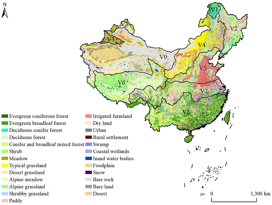
Figure 1. Forest cover in China.
Fire Occurrence and Burned Area Data
According to the fire season (Tian et al., 2015) and forest distribution for each vegetation zone, false hotspots were filtered from MCD64A1 data by using forest distribution maps and the fire seasons for each region. The spatial distribution of fires in each vegetation zone were analyzed. A fire density map was created using the kernel density method with a search radius of 100 km from the ignition points. High values of kernel density indicate a high frequency of fire occurrence (Berke, 2004). Fire density was divided into five classes using the Natural Breaks (Jenks) method (Yang et al., 2020): very low, low, moderate, high and very high. We used the Euclidean distance method to draw the distance distribution map of fires and densely populated areas, and used the Pearson correlation coefficient to analyze the correlation between fire density and population density in each vegetation zone.
Fires were classified into fire size (FS) according to the burned areas of each fire (State Council, 2008): <1,000 ha, 1,000–10,000 ha, and −≥10,000 ha. The percentage of different fire size classes in each vegetation zone was calculated. The average burned area per fire for each vegetation zone was calculated by total burned area divided by total forest fires.
The seasons were defined as spring (1 March−31 May), summer (1 June−31 August), autumn (1 September−30 November) and winter (1 December−28/29 February) (Wang et al., 2008). The fire seasons for every vegetation zone were determined according to the burn date derived from MCD64A1 data.
Climate Data Processing and Fire Weather Index Calculation
Stations were excluded from analyses if the amount of missing data exceeded 5% of the total during 2007–2017. We obtained data for the fire weather index calculation from 2,182 weather stations, accounting for 90% of total weather stations. The missing data of these stations were filled using the following method. For missing temperature, wind speed and relative humidity data, we used the sliding average of the previous and subsequent 5 days to replace the missing data. The missing precipitation data were replaced with values from neighboring meteorological stations.
Observations at noon were used to calculate the fire weather indices (FWI) according to the time zone of the weather station location, which were 15:00 (UTC/GMT+05:00), 14:00 (UTC/GMT+06:00), 13:00 (UTC/GMT+07:00), 12:00 (UTC/GMT+08:00) and 11:00 (UTC/GMT+09:00). We used the “cffdrs” (Canadian Forest Fire Danger Rating System) R package to calculate the daily FWI (Wang et al., 2017) based on noon temperature, relative humidity, wind speed and precipitation. This included the fine fuel moisture code, duff moisture code, drought code, initial spread index, buildup index, fire weather index, and daily severity rating (DSR) (VanWagner, 1987). We used the median of DSR (50th percentile) over an entire fire season to compute the seasonal severity rating (SSR), which provided a general proxy of the potential difficulty of fire control over an entire season (Dupuy et al., 2019). The SSR was calculated for every season (spring, summer, autumn and winter) because fire seasons can vary depending on vegetation zones. If the fire season included two or three natural seasons, we used the highest value of SSR. The spatial interpolation of these scenarios was carried out using ANUSPLIN 4.36 software (Hutchinson, 2006).
Fire Regime Zoning
Fire regime zones are generated from fire characteristics analysis. We classified areas with the same fire regime characteristics into one category (a fire regime zone code). However, fire behaviors in a fire regime zone differ due to forest type, burn season and climate/weather conditions. Therefore, we used a k-means clustering algorithm (Harrell, 2019) with quantitative variables to classify the fire regime zones, and adopted fire regime unit to give the final zoning results. If the regions had the same fire regime characteristics but a spread of different vegetation zones, we defined them with different fire regime units under a fire regime zone.
We calculated the fire season duration, average burned area per fire, and SSR for each vegetation zone. Those quantitative variables were normalized by formula (1) for building the fire regime zoning system, including the variables of fire density, average burned area per fire, fire season duration, and SSR.
y is the normalized value; x is the variable, and xmax and xmin correspond to the maximum and minimum values of variables, respectively.
The k-means clustering algorithm was used to conduct a clustering analysis based on the normalized indices. The core idea of the algorithm is to determine k central clustering points from n data so that the sum of the squares of the distances from the data points in each cluster to the clustering center is minimized (MacQueen, 1967). The initial value of k was set to 8 after experiments, the output index “sum of squares between groups divided by total sum of square” is 100%. We then classified the fire regime units by combining the clustering results (fire regime zones), vegetation regions, and fire seasons.
Results
Fire Characteristics Across China
The annual average number of fires in China between 2000 and 2020 was 6,283 (range from 1,153 to 14,144) and average burned area was 183,126 ha (range from 18,161 to 1,123,751). The maximum burned areas and average burned area per fire occurred in 2003, with 1,123,751 and 107.4 ha, respectively as shown in Figure 2A. The maximum annual number of fires (14,144) occurred in 2008, while the average burned area per fire was just 13 ha. The annual number of fires and burned area decreased significantly after 2010, but the average burned area per fire increased a little in 2020, as shown in Figure 2B.
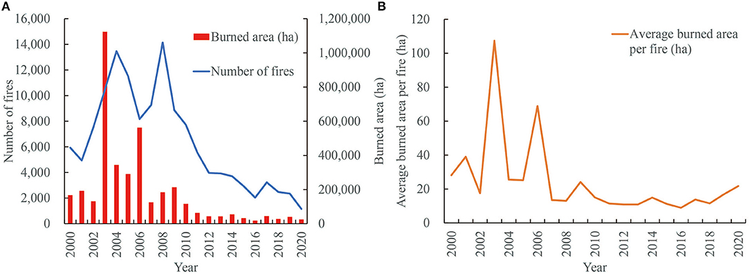
Figure 2. Annual fires, burned area and average burned area per fire during the period 2000–2020. (A) changes of annual fires and burned area; (B) changes of annual average burned area per fire.
Human-caused and lightning-caused fires accounted for 95.7% and 4.3% of all forest fires during the period 2000–2020, respectively. Fire density was positively correlated with population density (r > 0.5). Forest fires were primarily concentrated in southern China during the two decades, and the fire density was low in other regions. Areas with high (0.05–0.07) or very high (0.08–0.1) fire density accounted for 2.7 and 7.5% of the total, respectively, and were mainly distributed in southeastern and southwestern China—the regions with high population density (>4,351 person/km2) (Figure 3). Population density in northern of the V2 zone was less than one person/km2, but fire density was higher (0.02–0.04) because lightning fires were more frequent.
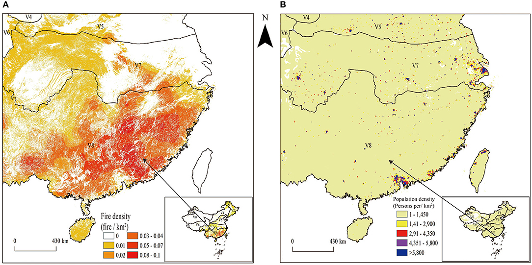
Figure 3. Spatial pattern of fire density and population density. (A) fire density map; (B) population density map.
Fires of <1,000 ha accounted for 99.9% of total fires from 2000 to 2020. These fires were concentrated in southern China and were less common in the northeast, as shown in Figure 4A. Fires of 1,000–10,000 ha were concentrated in northeastern China and were infrequent in the south, as shown in Figure 4A. Big fires (≥10,000 ha) only occurred in the northeast, as shown in Figure 4A. Fires of FS <1,000 ha in the V8 zone accounted for 59.8% of the total for the whole country. Those fires were mainly distributed in the southeastern and southwestern parts of the zone. However, the proportion of fires of 1,000–10,000 ha was <0.1%, and no big fires (>10,000 ha) occurred. The V2 zone had the most medium-sized fires and the largest burned areas, which included 57.1% of fires (1,000–10,000 ha) and 100% big fires (>10,000 ha). The proportion of fires with FS <1,000 ha in V3 and V6 was <1%, and no fires of FS>1,000 ha occurred in the period.
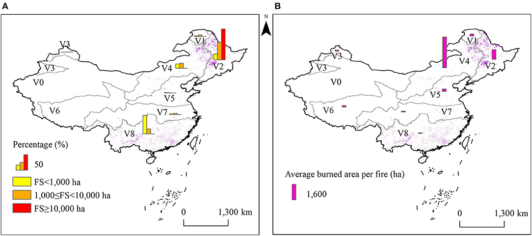
Figure 4. Percentage of fires in different fire size classes. (A) percentage of fires with different fire size; (B) average burned area per fire.
Fires of size >1,000 ha were the main determinant of the total burned area. The average burned areas per fire were relatively high in northeastern and northern China and low in the south, as shown in Figure 4B. The V4 zone had maximum (32,22.2 ha) of the burned areas per fire out of all the vegetation zones. Large fires mainly occurred in the V1 zone. The V8 zone had the minimum burned area per fire (65.4 ha).
Most vegetation zones had a long fire season (>6 months) (Table 1). The spatial distributions of burned area differed by season (Figure 5). Spring was a fire season for all vegetation zones and was also the season with the highest frequency of forest fires. The burned areas in spring were mainly distributed in the V2, V4, and V8 zones, which accounted for 43.9, 28.8, and 20.9% of the total, respectively. In summer, fires mainly occurred in V1 (30.9%) and V2 (65.3%), and only a few fires were documented in V4 (3.5%) and V3 (0.4%). The distribution of the burn area in autumn was like that of spring—mainly in V2 (55%), V4 (13.6%), and V8 (27.3%). The burned areas in winter were mainly in V8 (92.4%).
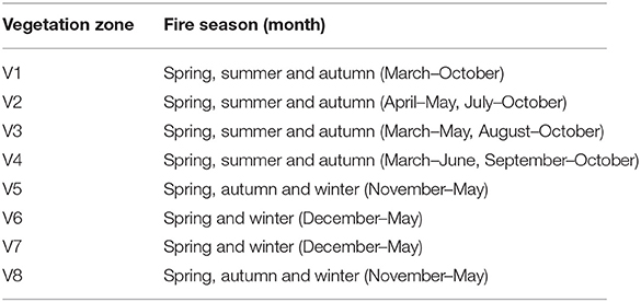
Table 1. Fire seasons for each vegetation zone.
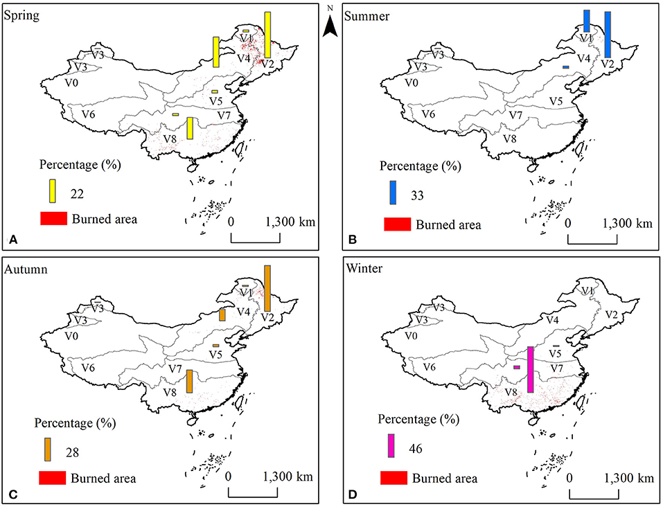
Figure 5. Percentage of burned area in different seasons. (A) percentage of burned area in spring; (B) percentage of burned area in summer; (C) percentage of burned area in autumn; (D) percentage of burned area in winter.
The median value of SSR in spring for the entire country was 10.3, which was significantly higher compared with other seasons (P < 0.01). SSR in the belt from southwest to northeast was higher compared with other regions, and SSR was higher in southwestern and northern China (Figure 6). In summer and autumn, high SSR was concentrated in the northwest (V3 and V4), and SSR was low in northeastern China (V1 and V2). The SSR distribution in southern and southwestern China showed a similar tendency in winter and spring. SSR was higher for V7 and V8 in the southwest compared with eastern China.
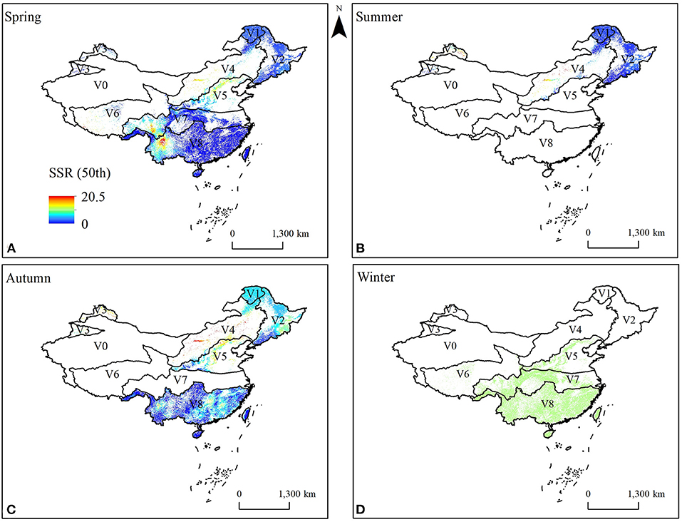
Figure 6. The spatial distribution of SSR 50th percentile for each season. (A) SSR 50th percentile in spring; (B) SSR 50th percentile in summer; (C) SSR 50th percentile in autumn; (D) SSR 50th percentile in winter.
Fire Regime Zones
We outlined 13 fire regime zones (FRZ) (17 fire regime units) across China based on the cluster results of the fire regime characteristics and vegetation types (Figure 7). FRZ I, II, III, and IV are distributed in the northeast and northwest and are characterized by large average burned areas per fire, a low frequency of fire occurrence, and a long fire season (including spring, summer and autumn). FRZ I had the largest burned areas over the two decades and very low population density (Table 2). In FRZ II, III, and IV, summer (July and August) is not part of the fire season because of the high amount of precipitation. The summer also overlaps with the plant growing season. FRZ VII 1, VIII, and IX are distributed in southeastern and south-central China, and are characterized by a higher frequency of fire and a fire season including winter and spring. FRZ IX has the highest FD and high average burned areas per fire. Although FRZ VIII and VII-1 have higher population densities than FRZ IX, they have smaller average burned areas per fire (<50 ha) because of differences in climate and vegetation. Both FRZ V and VII consist of two units—V-1 and V-2, and VII-1 and VII-2. The units within each type showed the same fire regime characteristics but differed in climate and vegetation type. FRZ X, XI, and XII are mainly distributed in southwestern China and have high median SSR values. FRZ X has a higher population density and fire density compared to FRZ XI and XII, but its average burned area per fire is lower compared to FRZ XI. FRZ XII has the highest SSR because of low precipitation, but its average burned area per fire was lowest because the region has sparse forest distribution. We attribute the areas characterized by scattered distribution of small forests and rare fires to FRZ XIII, made up of XIII-1, XIII-2, and XIII-3.
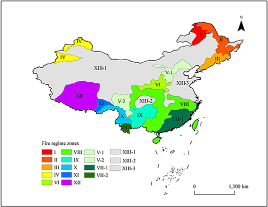
Figure 7. Fire regime zones in China. For detailed information on each FRZ see Table 2.
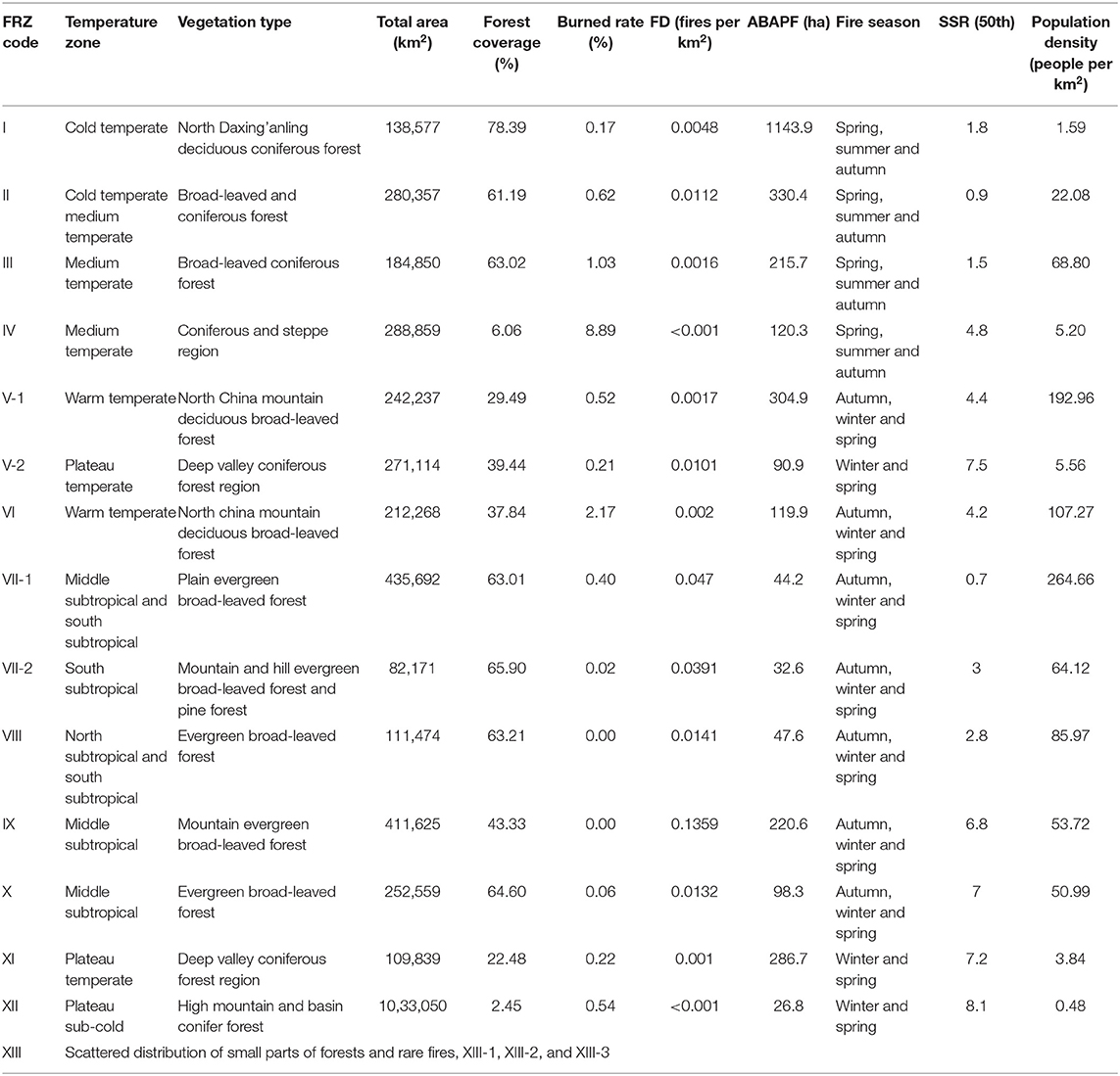
Table 2. Characteristics of each fire regime zone.
Discussion
We have established a fire regime zoning system for China based on fire regime features and vegetation type using qualitative and quantitative methods. Fire regime characteristics were classified by using a k-means clustering algorithm based on fire features (fire density and average burned area per fire) and fire weather (fire season duration and SSR). Forest fires mainly occurred in the southeastern, southwestern and northeastern forest regions. Fire occurrence was higher, and burned areas lower in southwest China. Fire density in northeast China was low, but fire size was large.
A fire regime zoning system is a useful framework for understanding the interaction between fire disturbance and ecosystem dynamics. It also helps explain the characteristics of fire regimes (Krawchuk et al., 2009; Parisien and Moritz, 2009), and allows for policies on fire management and suppression to be devised (Whitman et al., 2015; Stralberg et al., 2018; Erni et al., 2020). Fires with large burned areas and extreme fire behavior usually cause serious damage to forest resources and the social environment (Balshi et al., 2009). Fire agencies in these regions should have management strategies and take active measures on fire prevention, such as fuel treatment, firebreak construction, and improving fire suppression abilities, especially in northern China's boreal forests (Zong et al., 2021). In regions, such as southern China, with frequent fires but smaller burned areas, fire agencies should work to reduce the occurrence of fires caused by human activities (Tian et al., 2015). Overall, our fire regime zoning system provides accurate information on the fire regime of each region, which can be used to aid regional management of forest fires.
Human-caused ignitions are the main cause of forest fires in China; lightning fires are rare and are generally restricted to the northeastern region (mainly in V1). Most forests burn as surface fires (Zong and Tian, 2019); crown fires mainly occur in coniferous and mixed forest areas (Li et al., 2020), and ground fires only occur in small areas in the northeastern and northwestern forest regions (Zhang and Di, 2018). Previous studies have shown that the number of small fires in evergreen broad-leaved forests is higher in southern China, and large fires often occur in deciduous coniferous forests and mixed forests in the northeast (Tian et al., 2013, 2015; Wu et al., 2020). Fires in southern areas are mainly caused by human activities, and are easily discovered at an early stage due to the high population density (Tian et al., 2015). The mosaic of forests and farmlands in southern China is adverse to fire spread on large-scale (Yi et al., 1995). Lightning fires mainly occur in the northeastern forest region, especially in the natural forest areas of the V1 zone (Guo et al., 2009; Tian et al., 2009), and fires in remote mountain areas are difficult to discover and control (Fan and Wang, 2015; Zhang and Ding, 2019). The characteristics of fuel types, such as high-loading and fuel ladders in boreal forests help the spread of high-intensity surface fires and crown fires (Tian et al., 2005).
SSR reflects the fire risk of regions within a season. The southwestern region is affected by the dry summer monsoon, and its climate is divided into a dry and rainy season (Fan and Wang, 2015; Hu and Liang, 2015). Consequently, the SSR is high in the dry season. In winter, the precipitation in southern China is concentrated in the central and eastern regions, and the southwestern forest region has a relatively high SSR because of low precipitation and high temperature (Sun and Ao, 2013). Therefore, the northeastern and southwestern forest regions are a priority for forest fire management. Making full use of various parameters is central to improving the accuracy of fire regime zoning (Burton et al., 2009; Erni et al., 2020). We did not use the cause of fire and fire type as indices for fire regime zoning in this paper because of limitations in these data, but we do not expect that this would have significantly affected the fire regime zoning. The proposed FRZ in this paper was derived from the spatial information of burned areas and fire occurrence and statistical data over the past 20 years. This might be a short period in the context of fire regime research. Forest fires are greatly affected by management policies and management intensity in China. The factors affecting forest fire management were consistent throughout the study period. The zoning results represent the fire regime characteristics in the current stage. Although clustering methods can affect FRZ results (Boulanger et al., 2012), the differences are generally small (e.g., the boundary between zones). Although the boundary shows as a line between two adjacent fire regime zones, it is, in fact a belt with a certain width and may change as factors change (Wu and Yang, 2002). Fire regime zoning should be reexamined in the future using this method but with a greater period of data accumulation.
Conclusion
Fire regime characteristics were analyzed using forest fire data from multiple sources. The forest areas in China were divided into 13 fire regime zones (17 fire regime units) by combining qualitative and quantitative methods. Human activity causes most forest fires. There are a greater number of smaller fires in the southern and southwestern regions. Most large fires occur in northeast China—the region with the greatest burned area over the past two decades. The fire season in southern and southwestern China is mainly in winter and spring; in northeastern China, the fire season is mainly in spring and autumn.
Our FRZ results may help forest fire management in China, and the management policies and measures should be uniformly applied to regions within a fire regime type. Management based on fire regime zoning will help improve the efficiency of forest fire management. More studies of fire regime zoning are needed, especially those that integrate more data on vegetation, ecology and meteorology.
Data Availability Statement
The raw data supporting the conclusions of this article will be made available by the authors, without undue reservation.
Author Contributions
XZ: methodology, data processing, and writing—original draft. XT: conceptualization, methodology, resources, writing—review and editing, and supervision. JL: contributed manuscript formats. All authors contributed to the article and approved the submitted version.
Funding
This study received financial support from National Natural Science Foundation of China (31770695) and Fundamental Research Funds of CAF (CAFYBB2019ZB003).
Conflict of Interest
The authors declare that the research was conducted in the absence of any commercial or financial relationships that could be construed as a potential conflict of interest.
Publisher's Note
All claims expressed in this article are solely those of the authors and do not necessarily represent those of their affiliated organizations, or those of the publisher, the editors and the reviewers. Any product that may be evaluated in this article, or claim that may be made by its manufacturer, is not guaranteed or endorsed by the publisher.
References
Balshi, M. S., McGuire, A. D., Duffy, P., Flannigan, M., Kicklighter, D. W., and Melillo, J. (2009). Vulnerability of carbon storage in North American boreal forests to wildfires during the 21st century. Global. Change. Biol. 15, 1491–1510. doi: 10.1111/j.1365-2486.2009.01877.x
Berke, O. (2004). Exploratory disease mapping: kriging the spatial risk function from regional count data. Int. J. Health. Geogr. 3, 1–11. doi: 10.1186/1476-072X-3-18
Boulanger, Y., Gauthier, S., and Burton, P. J. (2014). A refinement of models projecting future Canadian fire regimes using homogeneous fire regime zones. Can. J. For. Res. 44, 365–376. doi: 10.1139/cjfr-2013-0372
Boulanger, Y., Gauthier, S., Burton, P. J., and Vaillancourt, M. A. (2012). An alternative fire regime zonation for canada. Int. J. Wildland. Fire 21, 1052–1064. doi: 10.1071/WF11073
Boulanger, Y., Gauthier, S., Gray, D. R., Legoff, H., Lefort, P., and Morissette, J. (2013). Fire regime zonation under current and future climate over eastern canada. Ecol. Appl. 23, 904–923. doi: 10.1890/12-0698.1
Burton, P. J., Parisien, M. A., Hicke, J. A., Hall, R. J., and Freeburn, J. T. (2009). Large fires as agents of ecological diversity in the North American boreal forest. Int. J. Wildland. Fire 17, 754–767. doi: 10.1071/WF07149
Chuvieco, E., Giglio, L., and Justice, C. (2008). Global characterization of fire activity: toward defining fire regimes from Earth observation data. Glob. Chang. Biol. 14, 1488–1502. doi: 10.1111/j.1365-2486.2008.01585.x
Dupuy, J. L., Fargeon, H., Martin-StPaul, N., Pimont, F., Ruffault, J., Guijarro, M., et al. (2019). Climate change impact on future wildfire danger and activity in southern Europe. Ann. Forest. Sci. 77, 1–24. doi: 10.20944/preprints201910.0200.v1
Erni, S. S., Wang, X., Taylor, S., Yan, B., and Parisien, M. A. (2020). Developing a two-level fire regime zonation system for canada. Can. J. Forest. Res. 50, 259–273. doi: 10.1139/cjfr-2019-0191
Fan, S. R., and Wang, W. J. (2015). Spatial-temporal changes of spring precipitation in southwest China. J. Arid. Meteor. 33, 740–747.
Fu, B. J., Chen, L. D., and Liu, G. H. (1999). The objectives, tasks and characteristics of China ecological regionalization. Acta Ecol. Sin. 5, 591–595.
Gao, J. B., Huang, J., Li, S. C., and Cai, Y. L. (2010). New advances and development trends in the study of physical geography in China. Prog. Phys. Geog. 29, 1400–1407. doi: 10.11820/dlkxjz.2010.11.032
Guo, F. T., Hu, H. Q., and Ma, Z. H. (2009). Spatial point process for spatial distribution pattern of lightning-caused forest fires in DaXing'an Mountains. Acta Ecol. Sin. 29, 6741–6747.
Hanes, C. C., Wang, X., Jain, P., Parisien, M. A., Little, J. M., Flannigan, M. D., et al. (2019). Fire-regime changes in Canada over the last half century. Can. J. Forest. Res. 49, 256–269. doi: 10.1139/cjfr-2018-0293
Harrell, F. E. (2019). Package ‘hmisc'. CRAN2018, 2019, 235–236. Available online at: https://cran.uib.no/web/packages/Hmisc/Hmisc.pdf (accessed July 29, 2021).
Hu, H. R., and Liang, L. (2015). Climatic characteristics and regionalization of rainfall in southwest China in the last 50 years. J. Southwest. Univ. 37, 146–154. doi: 10.13718/j.cnki.xdzk.2015.07.022
Huo, H. B., Liu, D. J., Han, Y. J., L, J., Wu, X. Q., et al. (2008). Rank of the Regionalization on Nationwide Forest Fire Risk (LY/T 1063-2008). Beijing: China Standard Press.
Hutchinson, M. F. (2006). ANUSPLIN Version 4.36 User Guide. Canberra, ACT: Centre for Resource and Environmental Studies.
Jin, J. X., Wang, Y., Jiang, H., Kong, Y., Lu, X. H., and Zhang, X. Y. (2016). Optimizing ecological geographical division based on remote sensing and canonical correspondence analysis methods-taking China as an example. Sci. Sin. Ter. 46, 1188–1196. doi: 10.1007/s11430-016-5297-5
Krawchuk, M. A., Moritz, M. A., Parisien, M. A., Van Dorn, J., and Hayhoe, K. (2009). Global pyrogeography: the current and future distribution of wildfire. PloS ONE 4:e5102. doi: 10.1371/journal.pone.0005102
Li, Y., Wang, W., Zeng, W., Wang, J., and Meng, J. (2020). Development of crown ratio and height to crown base models for masson pine in southern China. Forests 11:1216. doi: 10.3390/f11111216
MacQueen, J. (1967). “Some methods for classification and analysis of multivariate observations,” in Proceedings of the Fifth Berkeley Symposium on Mathematical Statistics and Probability. Available online at: https://www.researchgate.net/publication/220049032_Some_Methods_for_Classification_and_Analysis_of_MultiVariate_Observations
Marcoux, H. M., Gergel, S. E., and Daniels, L. D. (2013). Mixed-severity fire regimes: how well are they represented by existing fire-regime classification systems? Can. J. For. Res. 43, 658–668. doi: 10.1139/cjfr-2012-0449
Parisien, M. A., and Moritz, M. A. (2009). Environmental controls on the distribution of wildfire at multiple spatial scales. Ecol. Monogr. 79, 127–154. doi: 10.1890/07-1289.1
Rollins, M. G., Keane, R. E., and Parsons, R. A. (2004). Mapping fuels and fire regimes using remote sensing, ecosystem simulation, and gradient modeling. Ecol. Appl. 14, 75–95. doi: 10.1890/02-5145
Scholtz, R., Fuhlendorf, S. D., Leis, S. A., Picotte, J. J., and Twidwell, D. (2018). Quantifying variance across spatial scales as part of fire regime classifications. Ecosphere 9:e02343. doi: 10.1002/ecs2.2343
Snelder, T., Lehmann, A., Lamouroux, N., Leathwick, J., and Allenbach, K. (2010). Effect of classification procedure on the performance of numerically defined ecological regions. Environ. Manag. 45, 939–952. doi: 10.1007/s00267-010-9465-7
State Council. (2008). Forest Fire Protection Regulation. Available online at: http://www.gov.cn/gongbao/content/2008/content_1175820.htm
Stralberg, D., Wang, X., Parisien, M.-A., Robinne, F.-N., Sólymos, P., Mahon, C. L., et al. (2018). Wildfire-mediated vegetation change in boreal forests of Alberta, Canada. Ecosphere 9:e02156. doi: 10.1002/ecs2.2156
Sun, J. Q., and Ao, J. (2013). The response of winter precipitation and extreme precipitation in China to warming. Chin. Sci. Bull. 58, 674–679. doi: 10.1007/s11434-012-5542-z
Sun, S. Z. (1998). Concerning the vegetation Chinese regionalization map as a part of the natural geographical atlas of the peoples republic of China. J. Plant. Ecol. 6, 523–537.
Tian, X., Zhao, F., Shu, L., and Wang, M. (2013). Distribution characteristics and the influence factors of forest fires in China. Forest. Ecol. Manag. 310, 460–467. doi: 10.1016/j.foreco.2013.08.025
Tian, X. R., Shu, L. F., and Wang, M. Y. (2005). Influences of fire regime changes on the forest ecosystem in northeast China. Forest. Fire. Prev. 1, 21–25.
Tian, X. R., Shu, L. F., Wang, M. Y., and Zhao, F. J. (2009). Spatial and temporal distribution of lightning fire and forecasting model for daxing'anling region. Forest. Res. 22, 14–20.
Tian, X. R., Shu, L. F., Zhao, F. J., and Wang, M. Y. (2015). Fire regime analysis for ecological zones in Chinese mainland. Sci. Sil. Sin. 51, 74–80.
VanWagner, C. E. (1987). Development and Structure of the Canadian Forest Fire Weather Index System', Forestry Technical Report. Canadian Forestry Service Headquarters, Ottawa, ON.
Wang, H. L., Gan, Y., Wang, R. Y., Niu, J. Y., Zhao, H., Yang, Q. G., and Li, G. C. (2008). Phenological trends in winter wheat and spring cotton in response to climate changes in northwest China. Agr. Forest. Meteorol. 148, 1242–1251. doi: 10.1016/j.agrformet.2008.03.003
Wang, X., Wotton, B., Cantin, A., Parisien, M. A., Anderson, K., Moore, B., and Flannigan, M. (2017). An R package for the Canadian forest fire danger rating system. Ecol. Process. 6:5. doi: 10.1186/s13717-017-0070-z
Whitman, E., Batllori, E., Parisien, M.-A., Miller, C., Coop, J. D., and Krawchuk, M. A. (2015), The climate space of fire regimes in north-western North America. J. Biogeogr. 42, 1736–1749. doi: 10.1111/jbi.12533
Wu, S. H., Pan, T., Liu, Y. H., Deng, H. Y., Jiao, K. W., Lu, Q., et al. (2017). Comprehensive climate change risk regionalization of China. Acta. Geog. Sin. 72, 3–17. doi: 10.11821/dlxb201701001
Wu, S. H., and Yang, Q. Y. (2002). An index system for boundaries of eco-geographical regions of China. Prog. Phys. Geog. 21, 302–310. doi: 10.11820/dlkxjz.2002.04.002
Wu, Z., He, H. S., Keane, R. E., Zhu, Z., Wang, Y., and Shan, Y. (2020). Current and future patterns of forest fire occurrence in China. Int. J. Wildland. Fire 29, 104–119. doi: 10.1071/WF19039
Wu, Z., He, H. S., Yang, J., and Liang, Y. (2015). Defining fire environment zones in the boreal forests of northeastern China. Sci. Total. Environ. 518–519, 106–116. doi: 10.1016/j.scitotenv.2015.02.063
Yang, Q. Y., Zheng, D., Wu, S. H., and Ge, Q. S. (2005). Review and prospects: integrated physical geography in China since the 1950s. Geog. Res. 24, 899–910. doi: 10.11821/yj2005060009
Yang, S., Ge, M., Li, X., and Pan, C. (2020). The spatial distribution of the normal reference values of the activated partial thromboplastin time based on ArcGIS and GeoDA. Int. J. Biometeorol. 64, 779–790. doi: 10.1007/s00484-020-01868-2
Yi, H. R., He, X. P., Ji, P., and Zhang, Y. Z. (1995). Using NOAA/AVHRR data to monitor forest fires in southern forest areas. Remote Sens. Land Resour. 8, 24–30.
Zhang, J. L., and Di, X. Y. (2018). Research progress on underground fire and smoldering. Temp. For. Res. 1, 19–22+62.
Zhang, Y., and Ding, F. Y. (2019). Analysis on spatial distribution of forest disasters in China. J. B. Univ. For. 41, 68–79. doi: 10.13332/j.1000-1522.20180254
Zheng, D. (2008). Research on China's Ecological Geographical Region System. Beijing: The Commercial Press.
Zheng, J. Y., Yin, Y. H., and Li, B. Y. (2010). A new scheme for climate regionalization in China. Acta. Geog. Sin. 65, 3–12. doi: 10.11821/xb201001002
Zong, X. Z., and Tian, X. R. (2019). Research Progress in Forest Fire Behavior and Suppression Technology. World. Forestry. Res. 32, 31–36.
Keywords: fire regime, fire weather, forest fire, fire regime zonation, China
Citation: Zong X, Tian X and Liu J (2021) A Fire Regime Zoning System for China. Front. For. Glob. Change 4:717499. doi: 10.3389/ffgc.2021.717499
Received: 31 May 2021; Accepted: 15 September 2021;
Published: 20 October 2021.
Edited by:
Jose Ramon Gonzalez-Olabarria, Centre Tecnològic Forestal de Catalunya (CTFC), SpainReviewed by:
Lori D. Daniels, University of British Columbia, CanadaAdrián Jiménez Ruano, RMRS Missoula Fire Sciences Laboratory, United States Department of Agriculture (USDA), United States
Copyright © 2021 Zong, Tian and Liu. This is an open-access article distributed under the terms of the Creative Commons Attribution License (CC BY). The use, distribution or reproduction in other forums is permitted, provided the original author(s) and the copyright owner(s) are credited and that the original publication in this journal is cited, in accordance with accepted academic practice. No use, distribution or reproduction is permitted which does not comply with these terms.
*Correspondence: Xiaorui Tian, dGlhbnhyQGNhZi5hYy5jbg==