 Umer Abdela
 Dinku Shiferaw
 Seifeden Abdulsemed
 Mehasin Seid
94% of researchers rate our articles as excellent or good
Learn more about the work of our research integrity team to safeguard the quality of each article we publish.
Find out more
ORIGINAL RESEARCH article
Front. Environ. Sci., 25 March 2025
Sec. Ecosystem Restoration
Volume 13 - 2025 | https://doi.org/10.3389/fenvs.2025.1534850
This article is part of the Research TopicRestoring Our Blue Planet: Advances in Marine and Coastal RestorationView all 4 articles
The relationship between riverbank erosion and land use practices is a critical issue that impacting developing and developed nations and recognized as a significant environmental challenge, with human activities exacerbating it. In the same way, the floodplain of Weyb River in Agarfa district villages in southeast Ethiopia is confronting a significant challenge due to escalating riverbank erosion, posing a threat to the sustainability of this critical ecosystem. The findings from this study aim to evaluate the dynamics of riverbank erosion with land use practices and inform policymakers and stakeholders about the critical need for sustainable land use practices that mitigate erosion and enhance the resilience of affected communities. The study employed a mixed-methods approach, integrating quantitative and qualitative data collection techniques through field observations, community surveys and land-use land cover change analysis, this study has uncovered key insights into the complex relationship between land-use practices and erosion dynamics. Notably, the research identified significant erosion hotspots in villages such as Ambentu villages, Koloba Seada, and Harogoda, where 96.5% of respondents recognize drainage congestion along the river necessitating the operation of sluices. Moreover, Analysis reveals the intricate interplay between human activities and erosion dynamics. The study revealed critical causes of riverbank erosion, including excessive flooding and heavy rainfall upstream, and poor land cover along the riverbanks. Respondents identified that farming practices, particularly removing vegetation and farming near the riverbank, significantly contribute to erosion. Additionally, 92% of key informants agreed that agricultural activities such as seedlings rising near the river exacerbate erosion risks. The study recommends the development of river buffer zones, establishment of community conservation associations, implementation of riverbank rehabilitation measures, infrastructure development, community support and empowerment, deployment of developmental agents, and strengthening community adaptation to flood hazards. Urgent action is crucial to safeguard the Weyb River floodplain ecosystem and ensure long-term sustainability amid ongoing ecological changes and human interventions.
The relationship between riverbank erosion and land use practices is a critical issue that transcends geographical boundaries, impacting developing and developed nations. Globally, riverbank erosion is recognized as a significant environmental challenge, with human activities exacerbating it. For instance, Aslam et al. (2021) highlight that over 75% of the world’s ice-free land has been altered due to human activities, leading to increased vulnerability to erosion (Aslam et al., 2021). In developed countries, infrastructure development and urbanization have been linked to heightened erosion rates, as noted by Anthony et al. (2015), who reported significant sediment deficits in the Mekong Delta due to sand mining (Anthony et al., 2015). Conversely, the interplay between agricultural expansion and riverbank stability is particularly pronounced in developing countries. The removal of vegetation for farming purposes destabilizes soil structures, leading to increased erosion rates.
In Africa, the challenges posed by riverbank erosion are compounded by socio-economic factors and climate variability. The continent faces unique pressures, such as rapid population growth and land degradation, which exacerbate the impacts of erosion on livelihoods. Studies have indicated that removal of vegetation along riverbanks for agricultural expansion significantly increases soil erodibility. Furthermore, the intensification of extreme weather events, attributed climate change, poses a significant threat to riverbank stability across the continent. Increased precipitation can overwhelm riverbanks, thereby leading to accelerated erosion. Natural processes such as river flow, sediment transport, and vegetation dynamics play critical roles in shaping riverbanks. For instance, the bank erosion and accretion processes in alluvial Rivers are influenced by flow velocity, sediment supply, and bank material composition. Billah et al. (2022) observed that erosion and accretion patterns can vary significantly between riverbanks, with certain banks experiencing more pronounced erosion owing to their physical characteristics. Similarly, Nagy and Kiss (2020) noted that high flow velocities could exacerbate vertical erosion, particularly near revetments, leading to deeper channels and increased bank instability. Furthermore, the interaction between biotic factors, such as burrowing organisms, and abiotic factors contribute to the complexity of bank erosion processes. Studies by Sanders et al. (2021) demonstrate that the burrowing activities of signal crayfish can significantly increase bank erosion rates, highlighting the interplay between biological and physical processes in shaping riverbanks.
Human activities have been shown to exacerbate natural erosion processes, leading to accelerated bank erosion and its associated consequences. Activities such as sand mining, infrastructure development and land-use changes can disrupt the natural sediment balance and increase the vulnerability of riverbanks to erosion. For instance, Jordan et al. (2019) reported that sand mining in the Mekong Delta leads to significant sediment deficits, resulting in increased bank erosion and channel incision. Similarly, the construction of infrastructure, as discussed by Karmaker and Dutta (2016) can alter the hydrological dynamics of rivers, further contributing to bank instability. Moreover, anthropogenic factors such as vegetation loss have been linked to increased soil erodibility, as highlighted by Vázquez-Tarrío et al. (2024), which can exacerbate the effects of flowing water on bank stability.
Vegetation changes along riverbanks for agricultural and developmental purposes destabilized soil structures, which led to increased erosion rates and sediment transport (Dey and Mandal, 2022). Vegetation removal along river banks is a prevalent practice aimed at expanding agricultural land and facilitating development. However, this practice has direct effects on soil stability. Vegetation plays a crucial role in anchoring soil through root systems, which help to bind soil particles together. The absence of vegetation leads to increased soil susceptibility to erosion, as loose soil is more easily washed away by flowing water. Studies have shown that areas with intact vegetation experience significantly lower erosion rates compared to cleared areas (Wieting et al., 2023). The hydraulic properties of a river, including flow velocity and Water level fluctuations are critical in determining the rate of bank erosion. Strong currents exert substantial shear stress on the river banks, which can lead to mass failure and cantilever failure mechanisms (Aldefae et al., 2020). The interaction between hydraulic forces and sediment dynamics is complex; as sediment is eroded from the banks, it can be transported downstream, altering the river’s morphology and potentially leading to further erosion in other areas.
The intensification of extreme weather events, such as heavy rainfall and bank full discharge, has been linked to climate change and poses a significant threat to river bank stability. Increased precipitation can lead to rapid rises in water levels, overwhelming the capacity of river banks to withstand the hydraulic pressure. Research indicates that the frequency and intensity of such events are on the rise, further exacerbating the vulnerability of river banks to erosion (Babson, 2020). The cyclical nature of flooding and subsequent drying can also weaken soil structure, making it more prone to erosion. Cantilever failure occurs when a portion of the bank becomes unsupported due to erosion at its base, leading to the collapse of the overhanging material. This type of failure is particularly relevant in rivers with strong currents, where the hydraulic forces can undercut the bank. The interplay between hydraulic forces and the structural integrity of the bank material is a critical area of study for understanding erosion processes (Wilson et al., 2018). The hydraulic properties of a river, including flow velocity and turbulence, significantly influence erosion rates. Increased flow velocities can enhance the shear stress exerted on the bank, leading to higher erosion rates. Advanced modeling techniques incorporating data on water level fluctuations, sediment transport, and bank material properties have enabled researchers to predict erosion rates more accurately (Zhao et al., 2022). These models can identify vulnerable zones and inform targeted mitigation efforts.
Focusing specifically on Ethiopia, the Weyb River in the Agarfa District was selected as pertinent case study for understanding the dynamics of riverbank erosion and land use practices. The region is characterized by a complex interplay of natural and anthropogenic factors influencing erosion. The absence of stabilizing vegetation, coupled with loose soil composition, has resulted in significant erosion along the Weyb River. Moreover, the agricultural practices prevalent in the region, including the clearing of vegetation for crop production, further exacerbate the vulnerability of riverbanks to erosion In light of these considerations, the objectives of this study were 1) To examine the status of river bank erosion along the Weyb River and quantify land-use changes over a 30-year period (1991–2021) using multi-temporal Landsat satellite images and GIS techniques, and 2) To examine the relationship between bank erosion and agricultural land-use practices. The findings from this study aim to inform policymakers and stakeholders about the critical need for sustainable land use practices that mitigate erosion and enhance the resilience of affected communities.
The Weyb watershed, chosen as the focal point of this research, is situated in the upper part of the Weyb Sub-basin within the Genale-Dawa River basin in southeastern Ethiopia. This watershed lies specifically within the Oromia regional state, spanning latitudes 6°50′00′′ −7°25′00″N and longitudes 39°30′00″–40°34′00″E. Originating from the northern margins of the Bale Mountains, the main river courses through the Ethiopian Somali lands before eventually flowing into the Indian Ocean (Shawul et al., 2013). The watershed falls within the administrative boundaries of the Oromia regional state, primarily in the Bale zone, with some parts extending into the West Arsi zone. Notably, it encompasses seven districts from the Bale zone, including Agarfa, Dinsho, Sinana, Goba, Goro, Gasera, and Ginir, along with parts of the Adaba district from the West Arsi zone. The study area includes several key villages that are directly impacted by riverbank erosion along the Weyb River Ambentu villages, Harogoda, and Koloba Seada Village are Located near the banks of the Weyb River, and are characterized by their agricultural activities. The community primarily relies on farming for their livelihood. However, increased riverbank erosion has led to significant loss of arable land and reduced agricultural productivity. These villages are situated further downstream along the river and face similar challenges related to erosion. The residents of these areas engage in subsistence farming and are vulnerable to fluctuations in river dynamics that affect their crops and access to water resources. As a result, residents are increasingly concerned about food security and economic stability due to ongoing land loss.
The Weyb River originates from the Bale Mountains of Ethiopia, and its course has different characteristics. The mean bed slope, channel width, and bankfull discharge are not precisely available from the sources. The catchment drainage system of the Weyb watershed plays a critical role in managing water flow and sediment transport within the area. The drainage network consists of tributaries that feed into the Weyb River, contributing to its overall hydrology. These tributaries are essential for capturing rainfall runoff and directing it towards the main river channel. The catchment area is characterized by varying slopes that influence water movement; steeper slopes facilitate faster runoff, which can exacerbate erosion during heavy rainfall events. Understanding this drainage system is vital for assessing how land use practices such as deforestation and agricultural expansion impacts hydrological dynamics and contributes to riverbank erosion.
In general, the Weyb watershed, where the river flows, is characterized by gentle slopes, 73.65%, flat to undulating 23.70%, and limited steep hills and mountains of 2.65%. Materials constituting the bed and banks of the river probably originate from the surrounding geology and soils, which are mainly cambisol and luvisol. The exact composition of materials in the riverbed and bank, the mean bed slope, and the bankfull discharge will have to be defined with further field investigations and specific studies.
With respect to flow discharge, the average annual stream flow discharge in the Weyb River is 16.30 m3/second recorded from the Sofumer gauging station. In the absence of more data and studies pertaining specifically to hydraulic geometry, not much can be elaborated upon in terms of a detailed description regarding channel width and bankfull discharge. The bankfull discharge, which is the flow at which the river starts, overflowing into its banks, would require particular measurements of the cross-sectional area of the channel and the velocity of flow at that stage. The width of the channel would also change along the course of the river, due to variations in valley confinement, sediment supply, and flow regime (Dechasa et al., 2019). Further research is needed to obtain the measurements and data that will provide full characteristics of these aspects of the Weyb River.
The Weyb watershed features diverse topography characterized by plains and mountainous regions. Elevations within the watershed range from approximately 1,400 to 3,800 m above sea level, with about 61% of the area consisting of gently sloping plains and the remaining comprising rugged terrains and highland plateaus. This variation in elevation significantly influences local hydrology, land use practices, and agricultural productivity as different elevations affect microclimates and soil types.
The climate of the Weyb watershed is primarily characterized by a bimodal rainfall pattern, with two main rainy seasons: the long rains (Belg) occurring from March to May and the short rains (Kiremt) from June to September. Annual precipitation varies widely across the watershed, ranging from 400 mm to 1,200 mm. Seasonal variations in rainfall are critical for agricultural productivity since local farmers depend on these rains for crop cultivation. The average temperature ranges from 10°C to 25°C, creating favorable conditions for agricultural activities.
Hydrological, the watershed’s low regime was influenced by seasonal rainfall and topographical features. The annual flow rates of the Weyb River vary significantly, with extreme flow events occurring during peak rainy seasons. Historical data indicates that peak flow rates can exceed 500 m3/s during heavy rainfall, while low flow conditions may drop during dry months. These fluctuations impact not only water availability for irrigation but also contribute to riverbank erosion.
The soil within the Weyb watershed is predominantly composed of clayey and loamy textures, which are generally fertile but susceptible to erosion when exposed. Soil fertility varies across different areas due to land use practices; areas subjected to intensive agriculture often show signs of nutrient depletion. Soil erosion has led to significant loss of topsoil, further reducing agricultural productivity. Additionally, soil conservation practices are limited in this region, exacerbating erosion rates. The vegetation in the Weyb watershed consists mainly of mixed forests, grasslands, and agricultural lands. The highland areas are characterized by indigenous tree species that play a crucial role in maintaining soil stability and biodiversity. However, deforestation for agricultural expansion has led to habitat loss and increased vulnerability to erosion. The loss of vegetation cover reduces natural barriers against erosion and affects local ecosystems.
Land use within the Weyb watershed is primarily agricultural, with local communities engaging in subsistence farming. Key crops cultivated include linseed, wheat, barley, maize, green paper,and various vegetables. Agricultural practices are heavily influenced by seasonal rainfall patterns; farmers rely on rain-fed irrigation systems for their crops. The study area also includes grazing lands for livestock, which can contribute to soil compaction and erosion if not managed sustainably. The economic activity of residents in the Weyb watershed is predominantly agriculture. Approximately 70% of the households engaged in farming as their primary source of income. However, riverbank erosion has significantly impacted agricultural productivity, leading to an average income loss of 30% for the affected families. This economic strain has resulted in increased migration rates among residents seeking alternative livelihoods (Figure 1).
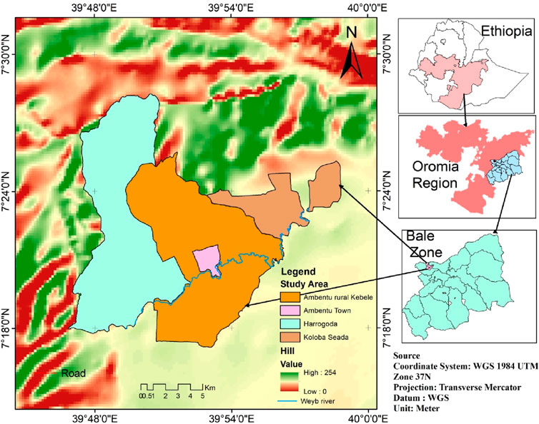
Figure 1. Location map of the study area
This research focuses on the Weyb River, located in the Agarfa District of Southeast Ethiopia. This region has been identified as particularly vulnerable to riverbank erosion, which poses significant threats to local communities, agricultural productivity, and overall ecosystem health. The Agarfa District is characterized by its reliance on agriculture and livestock, making the impacts of riverbank erosion, particularly critical for food security and livelihoods. The study employs a mixed-methods approach, integrating quantitative and qualitative data collection techniques to comprehensively assess the relationship between riverbank erosion and land use practices. The Weyb River is a vital water source for the surrounding communities, supporting irrigation and livestock needs. The area experiences seasonal flooding, which exacerbates erosion during heavy periods of heavy rainfall. Understanding these dynamics is essential for developing effective management strategies. To determine the appropriate sample size for the study, the following Cochran (1977) formula was utilized for estimating the required number of respondents (Equation 1).
Where: n = required sample size, Z = Z-value corresponding to the desired confidence level (e.g., 1.96 for a 95% confidence level), p = estimated proportion of the population (0.5 is used for maximum variability), and E = margin of error (e.g., 0.05). Using this formula, 250 farmers and households were approached, with 200 completed questionnaires returned, yielding a response rate of 80%. This sample size is sufficient to provide statistically significant insights into the dynamics of riverbank erosion and land use practices in the study area.
Data collection involved several methods to ensure the comprehensive coverage of the study objectives. The estimation of riverbank erosion is based on remote sensing and GIS techniques. The primary data were information from the topographic map of the study area at 1:250,000 scale for the year 1991–2021 used for base map preparation, four satellite images of Landsat images with 30 m spatial resolution for the years 1991, 2001, and 2022 were used for extracting bank lines for four different times and preparation of land use land cover maps (Chisti et al., 2023; Sarvjeet et al., 2024). Direct measurements of riverbank erosion and bank line shifting were conducted using surveying equipment, including erosion pins and GPS devices. Erosion pins were strategically placed along the riverbanks to monitor changes in bank position over time, while GPS devices were used to record the geographical coordinates of erosion sites. This quantitative data provides a robust foundation for understanding the dynamics of bank erosion along the Weyb River (Rosli et al., 2021). In addition, structured questionnaires were developed and administered to selected households to gather quantitative data regarding land use practices, perceptions of erosion, and socio-economic impacts. The questionnaires were designed based on study objectives and pre-tested for clarity and relevance. Questions include closed-ended items for quantitative analysis and open-ended items to capture qualitative insights. The data collected through questionnaires will be instrumental in identifying trends and correlations between land use practices and erosion rates.
Four focus group discussions (FGDs) were implemented, each group comprising six to eight participants, including local village leaders, district authorities, and zone representatives. These discussions aimed to gather qualitative insights into community perceptions of riverbank erosion and its impacts on livelihoods. The FGDs facilitated an interactive dialogue, allowing participants to express their views on the causes and consequences of erosion, as well as potential mitigation strategies (Bhuiyan et al., 2017). Semi-structured interviews with key informants including residents, agricultural experts, and environmental specialists, provided additional context and depth to quantify the findings. These interviews allowed for open-ended responses that could reveal nuanced perspectives on erosion dynamics and land use practices (Aslam et al., 2021). The insights gained from these interviews are crucial for understanding the socio-economic and environmental factors influencing riverbank erosion. Additional data were sourced from village authorities and other relevant institutions, including historical flood data, river erosion records, population demographics, and land use statistics. This data was complemented by literature reviews and online resources to provide a broader context for the findings. Historical records of flooding and erosion events are valuable for understanding the temporal dynamics of riverbank changes and the impact of climate variability on erosion processes (Nguyen and Khôi, 2020).
The collected data were systematically processed and analyzed using the Statistical Package for the Social Sciences (SPSS). This methodology involved several key steps to ensure a robust analysis and interpretation of the data related to riverbank erosion and land use practices. Descriptive statistics were used to summarize the demographic characteristics of the respondents, including age, gender, education level, and land ownership status. This involved calculating the frequencies and percentages for categorical variables. For instance, respondents’ ages were categorized into groups (e.g., 20–30, 31–40), and the percentage of respondents in each age group was calculated. In addition to demographic information, descriptive statistics were employed to present the prevalence of various land use practices among respondents. This included analyzing responses related to types of crops cultivated, distance from the riverbank, and farming methods employed. The satellite images were processed using the ERDAS Imagine 2015 software and mapping and analysis were performed using Arc GIS 10.7 software. The GIS method was used to model terrain evolution and landscape changes, which represented the basis for bank erosion intensity quantification. Comparative analyses were made, and images from 1992: A River bank area land use land cover change (LULCC) was calculated.
Furthermore, correlation analysis was conducted to examine relationships between land use practices (e.g., distance from the riverbank, type of crops) and riverbank erosion rates. The Pearson correlation coefficient was calculated to determine the strength and direction of this relationship. The following equation for Pearson correlation coefficient calculation was used:
Where: r = Pearson correlation coefficient = number of pairs = variable one (e.g., distance from river), y = variable two (e.g., erosion rate).
Moreover, regression analyses were conducted to identify significant predictors of erosion-based on land use practices. Multiple regression analysis helped assess how well independent variables (e.g., distance from riverbank, crop type) predicted the dependent variable (erosion rate) using the following equation for multiple regressions:
Where: Y = dependent variable (erosion rate),β0 = intercept, β1,β2,.,βn = coefficients for independent variables,X1,X2, ,Xn = independent variables (e.g., distance from riverbank), ϵ = error term.
The calculation of ANOVA (Analysis of Variance) is performed to determine if there are statistically significant differences in means across multiple groups, specifically in this study concerning erosion rates among different land use types. The ANOVA process begins by calculating the total sum of squares (SST), which measures the total variability in the data. This is followed by calculating the between-groups sum of squares (SSB) and the within-groups sum of squares (SSW). The degrees of freedom for each group are then determined. In addition, analysis was employed to interpret qualitative data obtained from Focus Group Discussions (FGDs) and semi-structured interviews. This process involved coding the data to identify key themes and patterns related to community perceptions, adaptive strategies, and socio-economic impacts of riverbank erosion (Langović, 2020). The qualitative insights will complement quantitative findings, providing a holistic understanding of the issues at hand.
The socio-economic conditions of the affected communities along the Weyb River reveal significant vulnerabilities that are closely tied to their demographic and educational profiles. A considerable portion of the population falls within the productive age range of 25–44 years; with 34.5% aged 25%–30% and 30.5% aged 35–44, which is crucial for agricultural productivity. However, many individuals in this demographic lack access to farmland, particularly in high-risk areas such as riverbanks and hillsides. This situation heightens their susceptibility to natural hazards, such as river overflow, which exacerbates their vulnerability and limits their capacity to adapt to erosion. Additionally, the gender distribution shows predominant male respondents (74%) compared to females (26%), suggesting traditional gender roles where men dominate agricultural activities while women primarily manage household responsibilities.
Despite this disparity, women do participate in farming, indicating an opportunity for increased involvement in decision-making processes related to land use and resource management. The data also highlighted critical issues related to marital status, education, and economic activities. With 80% of respondents being married, family responsibilities are significant, making any damage to crops or farmland due to erosion, particularly impactful on household wellbeing.
Educational attainment was notably low, with 57% of respondents lacking formal education, which limits their understanding of environmental hazards and effective adaptation strategies.
The distance of farmland from the riverbank during 1984 land distribution is based on the existence of arable land as there were wetlands of different sizes along the river. In the study area, the informant noticed that the rainfall intensity and distribution were declining. Consequently, the rainfall trend shows a decline, and other human activity affected the marsh area along the river; the wetlands dried up and finally converted to farmlands. This indicates that the distance of farmland from the river bank was wider during 1984 and after until the waterlogged area dried. However, the average farmland distance from the riverbank is only about 2.5 m. The implication of farming close to the riverbank increases the chance of damage to crops on the farmland. The research in line with this concept was conducted by Uddin et al. (2024) that state cropland is more vulnerable to potential flood risk compared to non-crop farmland. Studies show that proximity to rivers correlates with higher flood risk, necessitating better management strategies (Si-Nae et al., 2019). The table below shows the respondent’s perception of farming distance trends in the past and present (Table 1).
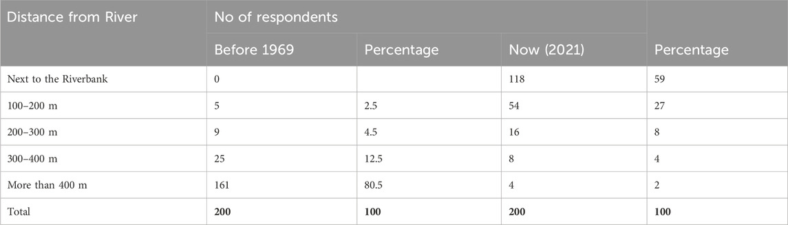
Table 1. Distance from river distribution.
In addition to farming along the river, there is intensive green paper seedling-raising activity. The seedling-raising activity is to plant on their farmland or for business objectives. The process of seedling production is not only conducted by farmers near the river but village residents and persons from others who live there for a temporary time. Although more than 50% of seedling works are conducted on the land under the Agarfa Technical and Vocational Education and Training College (ATVET) administration, it was much closer to the riverbank than farmlands on the side of study villages. The respondent justified that the closeness is for easily watering their seedling. In addition, 92% of key informants and 95% of focus group discussion participants agreed that seedling production practice is more degrading to river banks.
Furthermore, in case there is intensive rainfall in upper stream or highland areas of Agarfa and Dinsho districts, there is a high possibility of produced seedlings being taken by the river, and economic loss is high and forces the farmers to change what to cultivate on their farmland after 3–4 months effort. The majority (92%) of key informants believe that seedling production practices degrade riverbanks, leading to erosion and habitat loss. This finding is inconsistent with Muhammad et al. (2023) that the risk of seedlings being washed away during heavy rainfall events further exacerbates economic losses for farmers, forcing them to alter their cultivation practices after investing time and resources. Implementing sustainable seedling-raising methods, such as environmentally friendly materials and techniques, can mitigate some negative impacts on riverbanks (Zhao et al., 2019). Furthermore, this study finding is supported by more literature that shows the reduction in farmland distance from riverbanks, driven by land use changes and declining rainfall, poses significant risks to agricultural resilience. Historically, wetlands along riverbanks served as crucial buffers against flooding, but their conversion to farmland has decreased the average distance to riverbanks to about 2.5 m, increasing vulnerability to flood damage (Lin et al., 2023; Maoxin et al., 2023). Figure 2 below also supports the farming distance between villages.
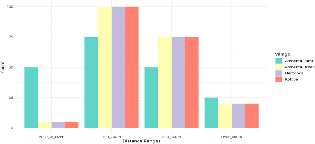
Figure 2. Farmland distance from the riverbank.
Respondents’ perceptions reflect shifting trends in farming distances from riverbanks. While historical data show that farmlands were farther away from the river; recent observations indicate a significant proportion located next to the riverbank. This spatial shift highlights the need for effective land-use planning to balance agricultural productivity with environmental sustainability (Xu et al., 2018). Sustainable land management strategies, informed by scientific research and community engagement are crucial for mitigating erosion risks in riverine areas (Huang et al., 2020).
Changes in farmland utilization patterns underscore the need for adaptive strategies to mitigate erosion risks and promote agricultural resilience. Shifts towards short-rotation crops and small-scale irrigation reflect farmers’ efforts to adapt to changing environmental conditions. However, the susceptibility of long-rotation crops to flooding highlights the importance of diversifying agricultural production systems and adopting climate-resilient crop varieties. This finding is consistent with Rajesh et al. (2024) and Chauhan (2024), that shows as implementing diverse cropping systems can reduce vulnerability to climate extremes and pests, as evidenced by successful case studies in various regions. Community-based initiatives, supported by scientific research and policy interventions are essential for fostering sustainable land management practices and enhancing the resilience of riverine agricultural systems (Gao et al., 2023). The findings highlight the complex interactions between land use changes, agricultural practices, and riverbank erosion.
Addressing the challenges related to farming proximity to riverbanks requires integrated approaches that encompass sustainable land management, community engagement, and policy support. Collaborative efforts between stakeholders, informed by scientific research and local knowledge, are essential for mitigating erosion risks and promoting the resilience of riverine agricultural systems. The finding aligns with other research reports that show Community-Based Initiatives through community involvement in sustainable land management practices foster resilience and ensure that strategies are contextually relevant (Vasavi and Nirmala, 2023; Rajesh et al., 2024) and Effective policies that promote multi-stakeholder partnerships are essential for scaling adaptive strategies and ensuring long-term sustainability (Feng et al., 2024; Chauhan, 2024).
The following comprehensive Table 2 detailing the land-use systems and vegetation status in the villages affected by riverbank erosion provides critical insights into the socio-economic and environmental challenges faced by the communities. The data indicates that 70% of the land use is dominated by grazing land, which is often waterlogged due to flooding from the Weyb River during the rainy season. This reliance on grazing land suggests that local livelihoods are heavily dependent on livestock, which can be severely impacted by flooding and erosion. The vulnerability of these lands to waterlogging not only threatens livestock health but also affects the availability of pasture, leading to potential food insecurity for both animals and humans. Therefore, there is an urgent need to implement sustainable grazing practices that minimize overgrazing and enhance soil health. Strategies such as rotational grazing could help maintain pasture quality and reduce soil compaction, thus improving resilience to flooding. Additionally, encouraging diversification into more resilient agricultural practices or alternative income sources may help mitigate risks associated with reliance on grazing.
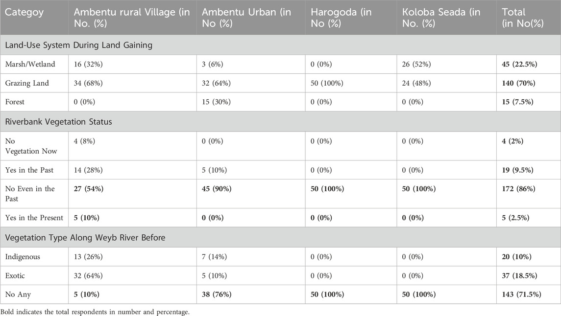
Table 2. Land use systems and vegetation status.
The findings also reveal a significant decline in natural riparian vegetation with many respondents indicating little to no significant riparian forest cover left along the riverbanks. The historical presence of hardwoods and grasses that once provided essential protection against erosion has diminished, leading to increased vulnerability of riverbanks during flood events. This situation underscores the critical need for reforestation initiatives targeted at restoring native riparian vegetation along the riverbanks. Such efforts can enhance soil stability and improve water quality, and provide habitat for local wildlife. Involving local communities in reforestation efforts can foster stewardship and increase awareness about maintaining healthy ecosystems.
Furthermore, the prevalence of exotic species, such as eucalyptus, has increased significantly, while indigenous species have decreased. This shift can disrupt local ecosystems, reduce biodiversity, and alter soil characteristics, potentially leading to further erosion issues. Therefore, strategies should be developed to manage and limit the spread of invasive exotic species while promoting the restoration of indigenous flora. This approach can help maintain ecological balance and support local biodiversity, recognizing the value of diverse ecosystems in enhancing ecosystem services such as flood regulation and soil fertility. The reliance on marshes and wetlands (22.5% of land use) highlights their importance for agriculture; however, these areas are also vulnerable to flooding. The data suggest a trend toward agricultural expansion into these sensitive areas, which may exacerbate erosion and reduce agricultural productivity. Developing integrated land use plans that consider flood risk management alongside agricultural needs is crucial. This could involve zoning regulations that protect sensitive areas while allowing for sustainable farming practices. Additionally, farmers should be supported in adopting adaptive strategies such as using short-rotation crops or implementing irrigation systems that can better withstand flooding conditions.
This study used spectral images from Landsat TM, ETM+, for the year 1991, 2001, and 2021 to evaluate land use and land cover changes in the study area. The methodology collects training samples to create classifications of satellite images using ERDAS Imagine software. The resulting land-use/land-cover maps for the specified years are shown in Figure 3. Initially, the images were classified into seven land cover classes: forestland, agricultural land, grassland, and shrubland. The extent of land use/land cover types along with respective percentages were summarized in Table 3. Table 3 shows changes in land use from 1991 to 2021. For instance, the area classified as Forest Land increased from 831 ha in 1991 to 1,483 ha in 2001 but then decreased to 173.08 ha by 2021, suggesting a trend of deforestation or conversion of forested areas to other uses over time. Agricultural Land saw a notable increase from 3,455 ha in 1991–10,640.72 ha in 2021, showing a substantial expansion of agricultural activities in the region.
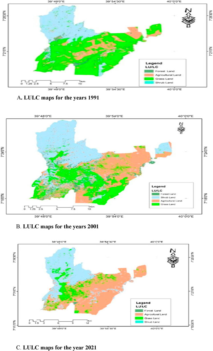
Figure 3. (A) LULC maps for the years 1991. (B) LULC maps for the years 2001. (C) LULC maps for the year 2021. ABC- LULC maps for the years 1991, 2001, and 2021 of the study area.
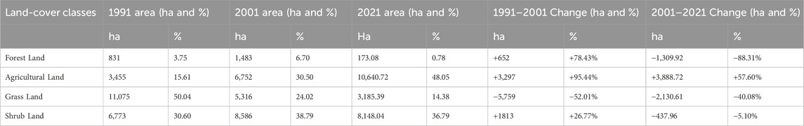
Table 3. Land-use/land-cover areas during 1991, 2001 and 202 in hectare and percentage.
Conversely, grasslands experienced a decline from 11,075 ha in 1991–3,185.395 ha in 2021, suggesting that these areas may have been converted to agricultural use or affected by other environmental changes. Shrub Land showed a slight increase from 6,773 ha in 1991–8,148.044 ha in 2021, which may reflect natural regrowth or changes in land management practices. The historical context reveals that wetlands along riverbanks serve as crucial buffers against flooding but have been increasingly converted into farmland due to declining rainfall patterns and human activities. This conversion has led to a decrease in the average distance between farmlands and riverbanks, increasing vulnerability to flood damage.
In the study area, the farmers especially those who know and farm that area recognized and realized contributors to the Weyb River overflow cause damage. They can be classified as there is a natural and man-made contributor to the Weyb River overflow to cause damage. As a result, the respondents listed, ranked, and agreed on the contributor of the Weyb River overflow causing damage to their farmlands and crops. The natural contributor to Weyb River overflow damage listed and proved by the respondent includes river channel curvature many times and flatness of lands on which rivers flow and farmland exists. The other cause of anthropogenic contributors to Weyb River overflowing damage is one-side river bank modification by Agarfa TVET College and related issues like the shift of the river bank and sedimentation from soil excavated. The next contributor to the Weyb River overflows to cause damage is people farming close to the river removing riparian vegetation from their side. According to the informant’s attitude, in addition to sedimentation from the college activity, the improper soil and water conservation practices in the upper stream, especially at Agarfa and Dinsho districts highland have contributed to the soil being carried by flood and being added to the river and increasing the sediment. In Harogoda village, there is no damage to river overflow history. This is due to the moderate slope and healthy river banks on both sides; however, there is a high volume of floodwater flowing from flood canals locally known as Jalba, Bore, and Kesiba causing topsoil removal from farmlands. As a result of topsoil removal, there is a patch of farmlands left empty of the soil. The flood from outside and finally added to the river damage also causes high damage at certain places where such collected flooding exists. For instance, there is damage to farmers’ land and crops in Kabar-Mude and Chalalaka areas (Supplementary Appendix Picture SA1, SA6).
Riverbank erosion occurs both naturally and through human activities. Rivers and streams are dynamic systems as they are constantly changing. The report revealed that the primary causes of riverbank erosion in the study area include excessive flooding, heavy rainfall upstream, poor land cover, soil structure, river morphology, and topography of both the river and adjacent areas. These factors collectively contribute to riverbank degradation, leading to significant ecological and economic consequences for local communities. This pattern of flooding is exacerbated by the rainfall upstream, which increases water flow into the river system. The lack of adequate vegetation along the riverbanks further compounds the problem, as it diminishes the natural barriers that help stabilize the soil. The lack of adequate vegetation along the riverbanks further compounded this problem, as it diminishes the natural barriers that help stabilize soil and prevent erosion. The report highlights that loose soil and silt composition along the banks make them particularly vulnerable to erosion when subjected to strong risk.
This study also points to poor land cover practices as a significant contributor to erosion. As agricultural activities expand closer to the riverbank, averaging only 2.5 m from the water’s edge, natural vegetation, once protected, the banks are removed. This shift not only increases vulnerability to erosion but also disrupts local ecosystems. These findings align with those of Li et al. (2020), which showed how both natural factors and human activities drive erosion processes.
Moreover, river morphology and topography play crucial roles in determining with the flat terrain in areas such as Ambentu Rural Village and Ambentu Urban promotes sediment deposition, which increases the risk of flooding. The geographical configuration of these villages creates conditions where floodwaters exert pressure on riverbanks, leading to further bank erosion. In addition to these environmental factors, human activities have significantly affected the health of the Weyb River ecosystem. Practices such as riparian vegetation removal for agriculture and green paper seedlings were raised close to the riverbank, indicating widespread recognition of their detrimental effects on riverbank stability.
The report revealed that the causes of riverbank erosion in the study area were excessive flood, heavy rainfall upstream, poor land cover along with the line, soil structure, river morphology, topography of the river and adjacent areas, and floods. The respondent observed and reported that the Weyb River experiences elevated levels of bank erosion and channel migration caused by its strong current, lack of riverbank vegetation, and loose soil and silt, which compose its banks. In addition, as illustrated in the figure below, the flatness of the three villages’ topography, the Geographical location of the villages, especially farmlands, and sedimentation contributed to the river damage (Figure 4).
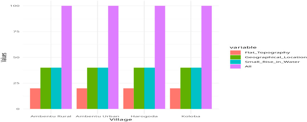
Figure 4. Contributors for the river to cause damage.
The results regarding erosion occurrence frequency across the villages of Ambentu Rural, Ambentu Urban, Harogoda, and Koloba Seada provide local perceptions of river impacts. According to the data, 21 respondents (42%) from Ambentu Urban and 31 respondents (62%) from Koloba Seada reported experiencing bank line erosion annually. In contrast, Harogoda reported no instances of annual erosion, indicating the village may have effectively managed practices or geographical factors that mitigate erosion risks. The data also showed that 24 respondents (48%) from Ambentu Rural and 29 respondents (58%) from Ambentu Urban indicated that erosion sometimes occurred. Notably, all 50 respondents (100%) from Harogoda acknowledged that erosion occurred occasionally, suggesting a heightened awareness of erosion issues in that area. The “Other” category received minimal responses, showing that most residents are aligned in their perceptions regarding the frequency of erosion events (Table 4).
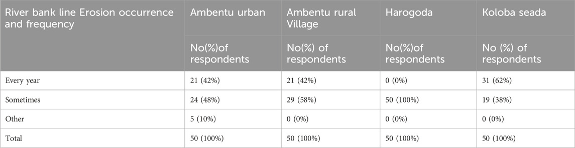
Table 4. Bank line erosion and flooding occurrence frequency.
The identified causes of riverbank erosion, including excessive flooding and poor land cover, were consistent with findings by Li et al. (2020), who highlighted the role of natural factors and anthropogenic activities in driving erosion processes. Studies by Calixto et al. (2024) further underscored the importance of vegetation in stabilizing riverbanks and mitigating erosion risks, emphasizing the need for sustainable land management practices.
Measurements for the items listed in Table 5 were obtained using a structured questionnaire administered to respondents within the study area. Each respondent was asked to rate the perceived impact of specific human activities on the Weyb riverbank ecosystem using a Likert scale ranging from one to 5, where one indicated “Not at all significant” and five indicated “Extremely significant.” These items included riparian vegetation removal for agricultural practices, farming close to the riverbank, and green paper seedling production close to the riverbank. The mean scores for each item were calculated by averaging the ratings provided by respondents, whereas standard deviations were computed to assess the variability of responses around the mean. For instance, “Collection of firewood” received a mean score of 1.86 with a standard deviation of 0.455, showing that respondents perceive this activity as having a minimal impact on riverbank health compared to other activities. This systematic approach allowed us to quantify community beliefs and identify which human activities were viewed as most detrimental to the riverbank ecosystem.
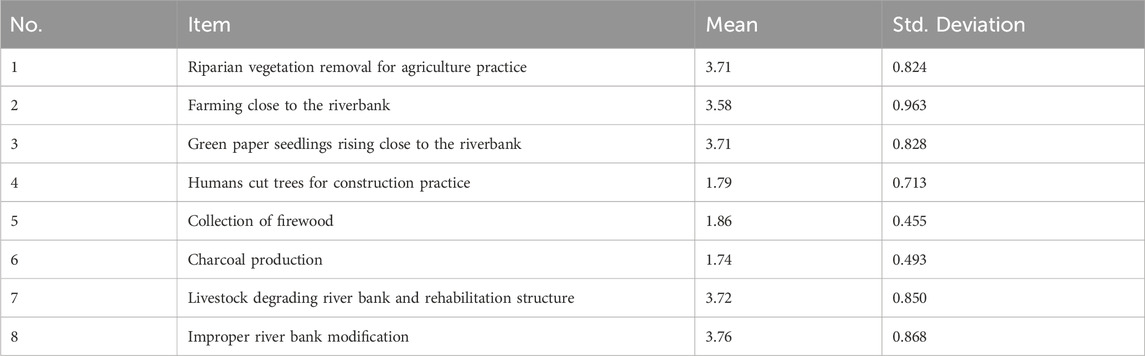
Table 5. Respondent’s view on the impacts of human activities in Weyb Riverbank Ecosystem.
Accordingly, the results from Table 5 indicate that human activities significantly impacting riverbank health are primarily related to agricultural practices. Activities such as “Riparian vegetation removal for agriculture practice” and “Green paper seedling raising close to the riverbank” received high mean scores of 3.71, suggesting that respondents perceived these practices as prevalent and detrimental to riverbank stability. Additionally, “Farming close to the riverbank” also scored notably high at 3.58, highlighting concerns about the proximity of agricultural activities to sensitive riparian zones. These findings emphasize the critical role that agricultural practices play in the degradation of river ecosystems. In contrast, activities such as “Humans cut trees for construction practice,” “Collection of firewood,” and “Charcoal production” received lower mean scores, indicating that respondents view these practices as significant contributors to riverbank degradation, with means ranging from 1.74 to 1.86. However, concerns remain regarding livestock management, as indicated by the mean score of 3.72 for “Livestock degrading river bank and rehabilitation structure,” and 3.76 for “Improper river bank modification.” The relatively low standard deviations across most items suggest a consensus among respondents regarding the impacts of these activities on riverbank health.
In the study area, farmers have identified both natural and anthropogenic factors contributing to Weyb River overflow and subsequent damage. Natural contributors include river channel curvature and the flatness of surrounding lands, which can exacerbate flooding (Xu et al., 2023). Anthropogenic contributors, such as riverbank modifications by Agarfa TVET College and farming close to riverbanks further compounds the risk of flooding and damage to farmlands (Xu et al., 2023). Improper soil and water conservation practices in upstream areas also contribute to sedimentation and soil erosion, increasing the severity of flooding events (Li et al., 2020). Respondents’ perceptions of the impacts of human activities on the Weyb Riverbank ecosystem reveal significant concerns. The removal of riparian vegetation for agriculture, farming near riverbanks, and intensive seedling-raising activities are identified as key factors contributing to ecosystem degradation (Yue et al., 2019).
Additionally, activities such as tree cutting for construction, collection of firewood, and livestock grazing further exacerbates riverbank erosion (Kimani, 2024). Improper riverbank modifications exacerbate erosion risks and compromise ecosystem resilience (Yan et al., 2024). These findings underscore the urgent need for sustainable land management practices and community-based conservation efforts to mitigate the impacts of human activities on river ecosystems.
This comprehensive table summarizes the status of riverbank erosion and observed incidences in the study area (Table 6). It highlights that soil erosion is a significant issue, reported by 74.5% of respondents, particularly in Ambentu Urban and Harogoda (Table 6). Bank failure and riverbank caving are also notable concerns, with riverbank slides affecting 11.5% of respondents. In terms of river channel changes, the data reveals that half of the respondents in Ambentu Rural Village and a significant majority in Ambentu Urban report widening channels, indicating potential changes in hydrology and sediment transport dynamics. Conversely, narrowing channels were reported by only 16.5%, suggesting varied perceptions among respondents regarding the stability and morphology of the river.
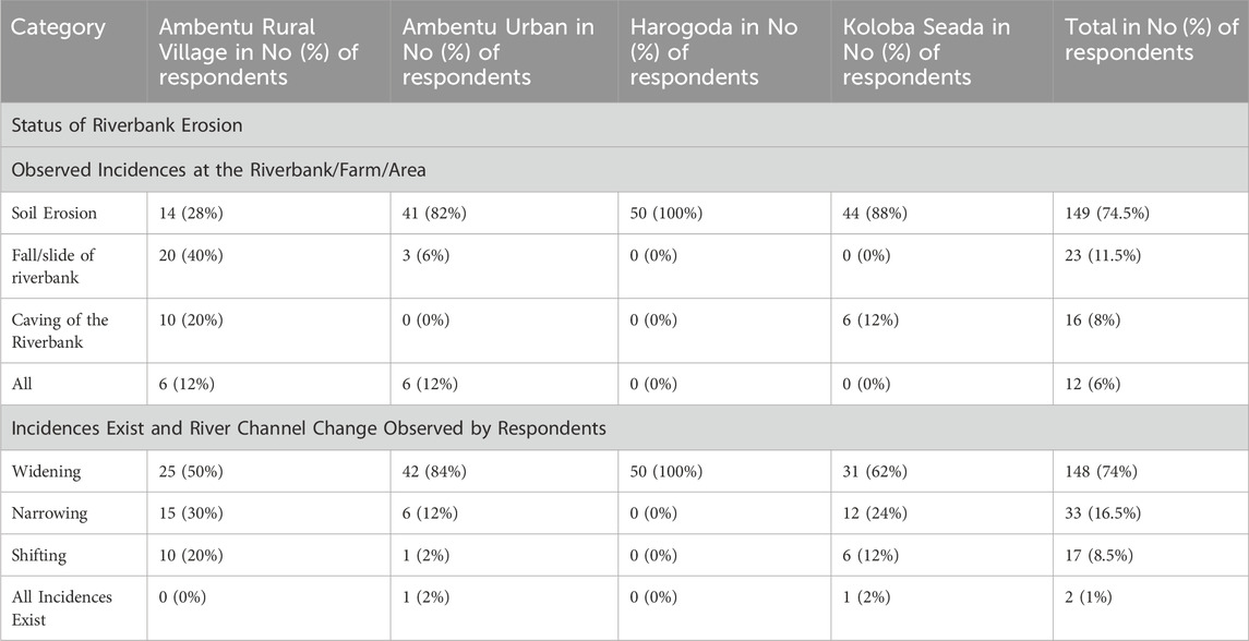
Table 6. Status of riverbank erosion and observed incidences.
The villages of Ambentu (urban and rural) and Koloba Seada are facing severe riverbank erosion, which aligns with findings from previous studies. Research by Singha et al. (2020) in neighboring regions highlighted similar patterns of erosion, emphasizing the vulnerability of riparian areas to frequent flooding and soil instability. Furthermore, the observed incidents of soil erosion, landslides, and riverbank caving resonate with studies by Wang et al. (2024), who identified these as common consequences of riverbank degradation in similar environments.
The data presented in Table 7 indicates significant variability in riverbank erosion rates across different locations along the Weyb River, largely influenced by land use practices. Ambentu Urban Village shows erosion rates of 0.95–1.25 m per year due to intensive agricultural activities. This suggests that the combination of soil disturbance from farming and increased runoff leads to bank loss. Koloba seada, with erosion rates of 1.02–1.3 m per year, reflects a mixed land use scenario, indicating that both agriculture and grazing contribute to destabilization. This highlights the need for integrated land management practices that consider the impacts of multiple land uses. Ambentu rural, where erosion reaches up to 2 m per year, demonstrates the effects of natural river dynamics exacerbated by human activity. The severe undercutting observed here suggests that certain geomorphological features can significantly amplify erosion when combined with anthropogenic factors. In contrast, relatively stable areas (Harogoda) exhibited minimal erosion (0.3–0.8 m per year), indicating that natural vegetation plays a crucial role in maintaining bank stability. This reinforces the importance of preserving natural ecosystems along riverbanks.
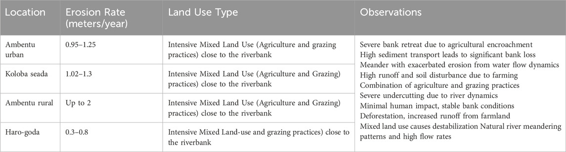
Table 7. Quantitative data on the rate of riverbank erosion.
There is significant variation in the average annual erosion rates observed across the Blackwater Catchment in Northern Ireland-from a low of 0.21 cm/year (0.0021 m) to 79.19 cm/year (0.7919 m) at one site (Hayes et al., 2024). This substantial range highlights how local conditions and land use practices can lead to different erosion outcomes within the same catchment area. The annual erosion rates recorded in Urban Village are significantly higher than those recorded in the Blackwater catchment. They range between 0.95 and 1.25 m a year, which is much higher than the minimum rates of erosion recorded in the Blackwater catchment but is below the maximum. This means that Urban Village is seriously eroding due to intensive agricultural activities, but certain sites in the Blackwater catchment are facing far more serious erosion, possibly due to specific local factors such as livestock access to riverbanks and changes in soil composition.
The findings indicate that intensive agricultural practices in Agarfa Village lead to high erosion rates per year aligns with similar studies conducted in various regions. For instance, a study by Shahab et al. (2022) found that soil erosion is significantly exacerbated by conventional agricultural practices, which disturb soil structure and then ease runoff. This similarity highlights a common trend where agricultural intensification negatively impacts soil stability and riverbank health. Conversely, research by Timothée et al. (2024) emphasizes sustainable agricultural practices, such as cover cropping and reduced tillage, which can mitigate erosion rates effectively. Their findings suggest that implementing such practices could reduce erosion by up to 50%, contrasting sharply with the high rates observed in Agarfa village. This indicates a critical need for adopting sustainable land management practices in the Weyb River floodplain to combat erosion.
The results in Table 8 reveal significant seasonal variations in erosion rates along the Weyb River, with critical implications for land management practices. Rainy Season (June to August) indicates a heightened vulnerability of riverbanks to erosion due to heavy rainfall and increased runoff. The dry season (December to February) shows lower erosion, suggesting that the absence of heavy rainfall allows for recovery of vegetation and soil stability.
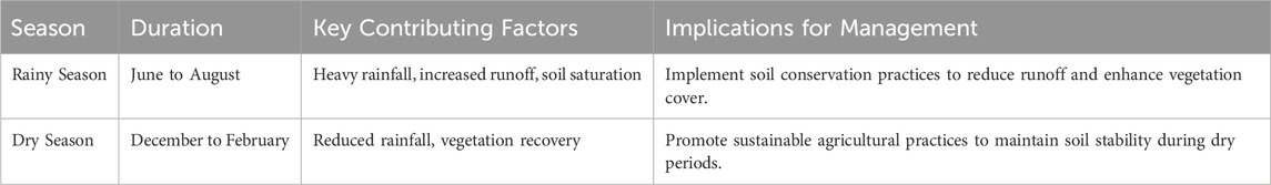
Table 8. Seasonal variations in erosion rates.
The results in Table 8 reveal significant seasonal variations in erosion rates along the Weyb River seasons, with critical implications for land management practices. This finding aligns with research conducted by Ziadat and Taimeh (2013), which demonstrated that heavy rainfall exacerbates soil erosion, particularly in areas with disturbed soils from agricultural practices. Their study highlighted that increased runoff during wet seasons can lead to significant soil loss; similar to what is observed in Agarfa Village. This approach is supported by García-Ruiz et al. (2013), who found integrating conservation techniques can significantly reduce erosion rates during peak rainfall periods. The observation of significant undercutting suggests that lower sections of the riverbank are eroding faster than upper sections, creating overhangs that are prone to collapse. This dynamic is consistent with findings by Leopold et al. (2020), who documented how river morphology influences sediment transport and bank stability. Their work illustrates that meandering rivers are particularly susceptible to erosion at bends, especially when human activities disturb natural vegetation. In addition, the slumping occurrence indicates a loss of structural integrity likely exacerbated by human activities such as deforestation or intensive agriculture.
The correlation between erosion rates and land use practices was calculated using the Pearson correlation coefficient (Equation 2). This statistical measure quantifies the strength and direction of a linear relationship between two variables: erosion rates and specific land-use practices, such as agricultural land use, grazing intensity, and urban development. The strong positive correlation between agricultural land use (r = 0.85, p < 0.01) and erosion rates indicates that as agricultural activities increase, erosion rates also rise significantly (Table 9). This finding aligns with existing literature that emphasizes the impact of intensive agricultural practices on soil stability, highlighting the urgent need to promote sustainable agricultural practices such as crop rotation and reduced tillage to mitigate erosion. The moderate positive correlation observed between grazing intensity (r = 0.65, p < 0.05) suggests that increased grazing is associated with higher erosion, consistent with research which indicates that overgrazing leads to soil compaction and reduced vegetation cover. The weak positive correlation between urban development (r = 0.40, p < 0.10) indicates that while urban expansion has a lesser impact on erosion, it still contributes to localized increases in soil loss. These findings align with those of Uday and Singh (2024) and Si-Nae et al. (2019), who highlighted the significant role of land use in shaping erosion dynamics and emphasized the need for sustainable land management strategies to mitigate erosion risks in vulnerable riverbank ecosystems.
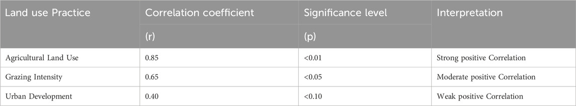
Table 9. Correlation coefficients for land use practices and erosion rates.
The multiple regression analysis used to evaluate the influence of land use practices on erosion rates was calculated by regressing various independent variables against the dependent variable, which in this case was the erosion rate (Equation 3). Accordingly, bank erosion was the dependent variable, while agricultural area, grazing intensity, and urban development were the independent variables. The coefficients indicate the expected change in erosion rates for a one-unit increase in each land-use practice. The multiple regression analysis emphasizes the significant influence of land use practices on erosion rates, with agricultural area (coefficient = 0.50, p < 0.01) having the most substantial effect, followed by grazing intensity (coefficient = 0.30, p < 0.05). This suggests that targeted interventions in agricultural practices should be prioritized to effectively reduce overall erosion rates in the region (Table 10). The analysis revealed that the agricultural area has a coefficient of 0.50 with a significance level of p < 0.01, indicating a strong positive relationship between agricultural land use and erosion rates. Similarly, grazing Intensity has a coefficient of 0.30 (p < 0.05), suggesting a moderate positive correlation, while urban development shows a weaker effect with a coefficient of 0.10 (p < 0.10).
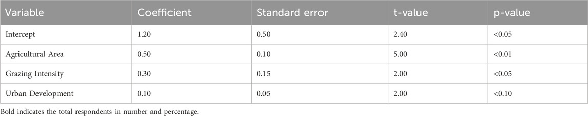
Table 10. Multiple regression analysis results.
The findings from the multiple regression analysis underscore the significant impact of land use practices on erosion rates within the study area. The analysis revealed that agricultural area has the most substantial effect on erosion rates, with a coefficient of 0.50 and a significance level of p < 0.01. This strong positive correlation suggests that as agricultural land use increases, erosion rates are likely to rise significantly. This aligns with previous research by Uday and Singh (2024), which indicates that cropland is more vulnerable to flood risks compared to non-crop farmland, highlighting the critical need for sustainable agricultural practices to mitigate erosion risks.
Moreover, grazing intensity contributes to erosion, with a coefficient of 0.30 (p < 0.05), indicating a moderately positive correlation between increased grazing and higher erosion rates. This finding is consistent with studies that emphasize the detrimental effects of livestock grazing on soil stability and vegetation cover along riverbanks (Calixto et al., 2024). In contrast, urban development shows a weaker relationship with erosion rates, evidenced by a coefficient of 0.10 (p < 0.10), suggesting that while urban activities may impact erosion, their effect is less pronounced than that of agricultural and grazing practices.
The ANOVA results indicate statistically significant differences in erosion rates among different land use types (F-value = 5.67, p < 0.01), the F-value of 5.67 indicates that the variability between groups (land use types) is significantly greater than the variability within groups. This statistical significance (p < 0.01) supports the assertion that land use type has a meaningful impact on erosion rates, underscoring the need for tailored management strategies for each land use type to address their specific contributions to erosion (Table 11). Overall, these findings highlight the complex relationships between land use practices and erosion rates along the Weyb River, emphasizing the importance of adopting effective land management strategies aimed at reducing erosion and protecting river ecosystems in the region. These findings are supported by existing literature that emphasizes the complex relationships between land use practices and erosion dynamics, indicating that effective land management strategies are essential for protecting river ecosystems (Uday and Singh, 2024; Si-Nae et al., 2019).
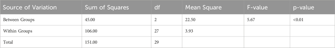
Table 11. ANOVA results for erosion rates across land use types.
This study acknowledges several limitations affecting the interpretation and generalizability of its findings. The reliance on qualitative data from focus groups and interviews introduces potential sampling bias and subjective interpretations, while temporal scale satellite image analysis can easily miss the most important erosion events that might fall between certain years. While focusing on a set of villages within the Weyb River floodplain clearly limits the broader applicability of such results. Besides problems in lack of bank line shift measurement, monetary valuation, the economic assessment also faces challenges with respect to the direct losses evaluated, where indirect economic impacts or social costs are not fully captured.
This study provides a comprehensive analysis of the factors influencing riverbank erosion and the implications of land use practices along the Weyb River. The findings underscore the complex interplay between agricultural activities, environmental conditions, and socio-economic impacts, highlighting several critical areas that require attention. The research indicates a significant reduction in the distance of farmland from the riverbank over time, now averaging only 2.5 m, compared to historical distances where farmlands were located much farther away. In 1984, most farmland was situated more than 400 m from the river, but recent data shows that 59% of respondents now report farming directly next to the riverbank. This shift has increased vulnerability to flooding and erosion, as proximity to the river correlates with higher flood risk. The conversion of wetlands to farmland has exacerbated this issue, leading to a decline in natural buffers against flooding. These findings highlight the urgent need for effective land-use planning that balances agricultural productivity with environmental sustainability.
Changes in farmland utilization patterns reflect farmers’ adaptive strategies to mitigate erosion isks and enhance agricultural resilience. The study highlights a trend towards short-rotation crops and small-scale irrigation as responses to changing environmental conditions. Approximately 70% of farmers reported shifting towards more resilient cropping practices in response to increased flooding events. However, long-rotation crops remain susceptible to flooding, emphasizing the importance of diversifying agricultural systems with climate-resilient crop varieties. Community-based initiatives are essential for fostering sustainable land management practices that can enhance resilience against climate extremes.
The findings reveal that 70% of land use is dominated by grazing land, which is often waterlogged due to flooding from the Weyb River during the rainy season. This reliance on grazing land suggests that local livelihoods are heavily dependent on livestock, which can be severely impacted by flooding and erosion. The vulnerability of these lands to waterlogging threatens livestock health and affects pasture availability, leading to potential food insecurity for both animals and humans. There is an urgent need to implement sustainable grazing practices that minimize overgrazing and enhance soil health.
Moreover, the study identifies both natural and anthropogenic contributors to flooding and riverbank erosion, including river channel curvature, sedimentation from human activities, and poor land cover practices. Approximately 37.5% of respondents indicated that river overflow occurs every year due to heavy rainfall upstream, while 58% reported it happening sometimes during high rainfall events. Understanding these contributors is vital for developing targeted interventions that address the root causes of flooding and protect local livelihoods. Human activities significantly impacting riverbank health are primarily related to agricultural practices.
Activities such as “riparian vegetation removal for agriculture” and “green paper seedling raising close to the riverbank” received high mean scores of 3.71, suggesting these practices are prevalent and detrimental to riverbank stability. In contrast, activities like “tree cutting for construction” received lower mean scores (1.74), indicating they are perceived as less significant contributors to degradation. However, livestock management remains a concern due to its contribution to bank degradation.
The analysis also highlights significant land use/land cover changes (LULCC) in the study area, particularly the conversion of river nearby wetlands into agricultural land, which has critical implications for both erosion rates and local biodiversity. Approximately 22.5% of land use is classified as marsh or wetland; however, these areas are increasingly being encroached upon by agriculture due to their perceived fertility. This trend not only increases erosion risks but also reduces biodiversity by eliminating natural habitats. The study underscores the criticality of addressing riverbank erosion and aggradation resulting from changing agricultural land-use practices in the floodplain of the Weyb River. While notable erosion activities are observed, there is a gradual decrease in these phenomena over time, albeit at a small rate. Specifically, soil erosion and riverbank erosion/aggradation activities due to agricultural land-use practices are remarkable but demonstrate a gradual decrease. Bank erosion in the study area exhibits variability on different sides at different times. Furthermore, the study indicates a concerning trend of increasing human interventions in floodplain areas, primarily driven by agricultural activities. The most affecting land-use class is agriculture, highlighting the significant impact of human activities on the ecosystem. This trend is expected to continue due to the projected population growth in the region, exacerbating environmental challenges and directly affecting the livelihoods of floodplain dwellers. The findings also reveal frequent and large-scale changes experienced in the floodplains of the study region, reflecting the dynamic nature of rivers and their impact on land use, particularly in agriculture.
Based on the findings of the investigation, the following recommendations are proposed to address the challenges posed by riverbank erosion and promote sustainable management of the floodplain ecosystem: Relevant sectors such as the agricultural office, river administration bodies, and academic institutions like Madda Walabu University and Agarfa TVET College, along with non-governmental organizations (NGOs), should collaborate to implement river buffer zone development interventions. This initiative would involve creating buffer zones along the riverbanks to mitigate erosion and preserve the ecological integrity of the floodplain. Encourage the formation of conservation associations within local communities and provide support for initiatives aimed at conserving riverbanks through plantation and soil and water conservation activities. These associations can play a crucial role in mobilizing community participation and fostering a sense of ownership over conservation efforts.
The key to effective riverbank rehabilitation is a balanced approach that attempts to provide immediate control over erosion while ensuring ecological health in the long term. While the removal of sediments and small islands from river channels may benefit the restoration of some natural flow dynamics, this must be weighed against the impacts that may occur due to sediment transport and resulting downstream erosion. Thus, a blend of strategies that focuses on sustainability alongside any essential structural interventions. This includes selective management of sediments whereby sites are chosen and considered for removal in order to restore flow dynamics while protecting the sediment supply necessary for downstream stability. Construct riverbank structures using durable materials such as stone or concrete blocks at water spill-off areas prone to erosion. Reinforcing vulnerable sections of the riverbanks with robust infrastructure will enhance their resilience to erosive forces and minimize damage during flooding events.
Mitigating the impacts of riverbank erosion, promoting sustainable land management practices, and enhancing the resilience of communities living in flood-prone areas of the Weyb River floodplain should be given due attention by all relevant stakeholders at all levels. Conduct comprehensive studies to evaluate the economic consequences of bank erosion on local communities, focusing on agricultural productivity losses and infrastructure damage. To effectively mitigate these challenges, it is essential to implement targeted interventions that focus on sustainable agricultural practices and community engagement. Future research should prioritize long-term monitoring of erosion rates about land use changes and evaluate the effectiveness of conservation measures implemented in the region. Additionally, assessing the economic impacts of bank erosion on local communities will provide valuable insights for developing comprehensive management strategies. Furthermore, research should be conducted on lateral channel migration during different time phases (long-term and short-term migration rates) and calculate the economic consequences caused by bank erosion on the community. Future research should explore long-term monitoring of erosion rates about land use changes, investigate the effectiveness of implemented conservation measures and assess community perceptions regarding these interventions.
The raw data supporting the conclusions of this article will be made available by the authors, without undue reservation.
UA: Conceptualization, Data curation, Formal Analysis, Funding acquisition, Investigation, Methodology, Project administration, Resources, Software, Supervision, Validation, Visualization, Writing–original draft, Writing–review and editing. DS: Data curation, Funding acquisition, Investigation, Supervision, Validation, Visualization, Writing–review and editing. SA: Conceptualization, Data curation, Funding acquisition, Investigation, Methodology, Software, Supervision, Writing–review and editing. MS: Investigation, Methodology, Project administration, Resources, Supervision, Validation, Visualization, Writing–review and editing.
The author(s) declare that financial support was received for the research, authorship, and/or publication of this article. We would like to express our sincere gratitude to Madda Walabu University for providing the necessary funding and support for conducting our research entitled “Relation of Riverbank Erosion with Land Use Practices on Floodplain of Weyb River at Agarfa District Villages, South East Ethiopia.” This financial assistance was crucial in facilitating our data collection efforts and enabling us to engage with local communities effectively.
We appreciate the university’s commitment to advancing research that addresses significant environmental challenges and contributes to the sustainable development of the region. Your support has been instrumental in enhancing our understanding of the complex interactions between riverbank erosion and land use practices, ultimately aiming to inform policy and management strategies that benefit both the environment and local livelihoods.
The authors declare that the research was conducted in the absence of any commercial or financial relationships that could be construed as a potential conflict of interest.
The author(s) declare that Generative AI was used in the creation of this manuscript. Language edition.
All claims expressed in this article are solely those of the authors and do not necessarily represent those of their affiliated organizations, or those of the publisher, the editors and the reviewers. Any product that may be evaluated in this article, or claim that may be made by its manufacturer, is not guaranteed or endorsed by the publisher.
The Supplementary Material for this article can be found online at: https://www.frontiersin.org/articles/10.3389/fenvs.2025.1534850/full#supplementary-material
Aldefae, A. H., Al-Khafaji, R. A., Shamkhi, M. S., and Kumar, H. Q. (2020). Erosion, sediments transport and riverbank stability: a review. IOP Conf. Ser. Mater. Sci. Eng. 901 (1), 012014. doi:10.1088/1757-899X/901/1/012014
Anthony, E., Brunier, G., Besset, M., Goichot, M., Dussouillez, P., and Nguyen, V. (2015). Linking rapid erosion of the Mekong River delta to human activities. Sci. Rep. 5 (1), 14745. doi:10.1038/srep14745
Aslam, R. M. S., Mayo, S. M., Ahmad, I., Ahmad, N., and Arif, H. (2021). Riverbank erosion and consequent land settlement issues: a case of river Chenab, district hafizabad. Int. J. Innovations Sci. Technol. 3 (4), 152–165. doi:10.33411/ijist/2021030402
Babson, S. (2020). Assessment of the interlinkages between coastal flooding, erosion, and cultural ecosystem services in ada. Ghana: Doctoral Dissertation, University Of Ghana.
Bhuiyan, M. A. H., Islam, S., and Azam, G. (2017). Exploring impacts and livelihood vulnerability of riverbank erosion hazard among rural household along the river Padma of Bangladesh. Environ. Syst. Res. 6 (1), 25. doi:10.1186/s40068-017-0102-9
Billah, M. M., Majumdar, A., Rahman, S. M. A., Hossain, M. J., and Talukder, J. (2022). Impact of riverbank erosion on rural food security in Bangladesh. doi:10.20944/preprints202207.0186.v1
Calixto, N. J. C., Castaño, A. G., and Contreras-Ropero, J. E. (2024). Bibliometric analysis of river erosion control measures: examination of practices and barriers in Colombia. Hydrology 11 (9), 139. doi:10.3390/hydrology11090139
Chisti, M., Samsunnahar, P., Islam, Md., Shafiqul, A., Selim, R., Mustafizur, R., et al. (2023). Quantifying River bank erosion and accretion patterns along the gorai River in kushtia, Bangladesh: a geospatial analysis utilizing GIS and remote sensing techniques. J. Geogr. Inf. Syst. 16 (01), 70–88. doi:10.4236/jgis.2024.161006
Dechasa, S., Koteswararao, B., and Unduche, F. S.Research Scholar, Mechanical Engineering Department, Koneru Lakshmaiah Education Foundation, Vaddeswaram, Guntur, A.P, India (2019). Biophysical characteristics of weyb watershed, bale mountainous area of the Southeastern Ethiopia. management 9, 515–521. doi:10.35940/ijitee.I7725.078919
Dey, S., and Mandal, S. (2022). Riverbank erosion hazards and channel morphodynamics: a perspective of fluvial geomorphology. India: Routledge. doi:10.4324/9781003276685
Feng, Q., Yang, H., Liu, Y., Liu, Z., Xia, S., and Wu, Z. (2024). Interdisciplinary perspectives on forest ecosystems and climate interplay: a review. Environ. Rev. 33, 1–21.
Gao, L., Mei, J., Li, J., Zhang, W., and Lai, C. (2023). Effect of intense rainfall and high riverine water level on compound flood hazards in a river-valley city: a case study of Yingde, China. J. Hydrol. 625, 130044.
García-Ruiz, J. M., Nadal-Romero, E., Lana-Renault, N., and Beguería, S. (2013). Erosion in Mediterranean landscapes: changes and future challenges. Geomorphology 198, 20–36. doi:10.1016/j.geomorph.2013.05.023
Hayes, E., Higgins, S., Mullan, D., and Geris, J. (2024). High-resolution assessment of riverbank erosion and stabilization techniques with associated water quality implications. Int. J. River Basin Manag. 22 (4), 611–625. doi:10.1080/15715124.2023.2214866
Huang, J., Reneau Jr, R. B., and Hagedorn, C. (2000). Nitrogen removal in constructed wetlands employed to treat domestic wastewater. Water Res. 34 (9), 2582–2588.
Jordan, C., Tiede, J., Lojek, O., Visscher, J., Apel, H., Nguyen, H. Q., et al. (2019). Sand mining in the Mekong Delta revisited - current scales of local sediment deficits. Sci. Rep. 9 (1), 17823. doi:10.1038/s41598-019-53804-z
Karmaker, T., and Dutta, S. (2016). Prediction of short-term morphological change in large braided river using 2D numerical model. J. Hydraulic Eng. 142 (10), 04016039. doi:10.1061/(ASCE)HY.1943-7900.0001167
Kimani, C. K. (2024). An assessment of the causes and effects of degradation on riparian ecosystems of the eastern semi-arid region of Kenya; A case study of Kaiti river, Makueni County (Doctoral dissertation). doi:10.9734/jalsi/2024/v27i3647
Langović, M. (2020). Investigation of the lateral channel migration: a case study of the south Morava river (Serbia). Glas. Srp. Geogr. Drustva 100 (1), 1–21. doi:10.2298/gsgd2001001l
Leopold, L. B., Wolman, M. G., Miller, J. P., and Wohl, E. E. (2020). Fluvial processes in geomorphology. Courier Dover Publications.
Li, Q., Wang, L., Ma, X., and Nie, R. (2020). Experimental study of effects of riverbed composition on the riverbank erosion process. Proc. Institution Civ. Engineers-Water Manag. 173 (4), 199–207. doi:10.1680/jwama.19.00058
Lin, J., Hui, W., Saige, W., and Wen, Z. (2023). Process analysis and mitigation strategies for wetland degradation caused by increasing agricultural water demand: an ecology economy nexus perspective. Ecol. Process. 12, 1–13. doi:10.1186/s13717-023-00452-x
Maoxin, Z., Ge, Z., He., , and Cifang, Wu (2023). A growing global threat: long-term trends show cropland exposure to flooding on the rise. Sci. Total Environ. 899, 165675. doi:10.1016/j.scitotenv.2023.165675
Muhammad, A., Niluh, P., and Evvy, R. (2023). Pelestarian Lingkungan dengan Konsep Penghijauan di Desa Kaliburu. J. Ris. Rumpun Ilmu Tanam. 2 (1), 01–07. doi:10.55606/jurrit.v2i1.1229
Nagy, J., and Kiss, T. (2020). Point-bar development under human impact: case study on the lower tisza river, Hungary. Geogr. Pannonica 24 (1), 1–12. doi:10.5937/gp24-23011
Nguyen, L. D. H., and Khôi, Đ. N. (2020). Using landsat satellite images for assessing riverbank changes in the Mekong and Bassac rivers in the an Giang province. Sci. and Technol. Dev. J. - Eng. Technol. 2 (SI2), First. doi:10.32508/stdjet.v2isi2.444
Rajesh., , Abhishek, J., Krithika, M., Pooja, B., Prasad, R. S., Anil., , et al. (2024). A review on adaptive strategies for climate resilience in agricultural extension services in India. Archives Curr. Res. Int. 24 (6), 140–150. doi:10.9734/acri/2024/v24i6772
Rosli, N. A. M. M. M., Ibrahim, S. S. L., Handan, R., and Salleh, N. (2021). Measurement of erosion rates of Pusu River using the erosion pinspins method. Int. JournalInternational J. Int. J. Integr. Eng. 13 (3). doi:10.30880/ijie.2021.13.03.017
Sanders, H., Rice, S. P., and Wood, P. J. (2021). Signal crayfish burrowing, bank retreat and sediment supply to rivers: a biophysical sediment budget. Earth Surf. Process. Landforms 46 (4), 837–852. doi:10.1002/esp.5070
Sarvjeet, K., Manish, P., and Anoo Kumar, S. (2024). Spatio-temporal analysis of riverbank changes using remote sensing and geographic information system. Phys. Chem. Earth 136, 103692. doi:10.1016/j.pce.2024.103692
Shahab, A., Malik, A.-W., Mohammad, R., Mehrdad, G., Mohammad, A., Jan, A., et al. (2022). “Soil erosion in the United States,” in Present and future. arXiv.org, 2020–2050. doi:10.48550/arXiv.2207.06579
Shawul, A. A., Alamirew, T., Melesse, A. M., and Chakma, S. (2016). “Climate change impact on the hydrology of Weyb River watershed, Bale mountainous area, Ethiopia,” in Landscape dynamics, soils and hydrological processes in varied climates, 587–613.
Si-Nae, K., Sang-Min, J., Hyunji, L., Soonho, H., and Moon, S. (2019). Establishment of inundation probability DB for forecasting the farmland inundation risk using. Weather Forecast Data 62 (4), 33–43. doi:10.5389/KSAE.2020.62.4.033
Singha, P., Das, P., Talukdar, S., and Pal, S. (2020). Modeling livelihood vulnerability in erosion and flooding-induced river island in Ganges riparian corridor, India. Ecol. Indic. 119, 106825. doi:10.1016/j.ecolind.2020.106825
Timothée, C., Charles, B., and Aurore, D. (2024). How much do conservation cropping practices mitigate runoff and soil erosion under Western European conditions: a focus on conservation tillage, tied ridging, and winter cover crops. Soil Use Manag. 40. doi:10.1111/sum.13047
Uday, P., and Singh, C. (2024). Climate change mitigation and adaptation strategies in agriculture. Indian Sci. J. Of Res. Eng. And Manag. 08 (06), 1–5. doi:10.55041/ijsrem35837
Uddin, M. R., Khandaker, M. U., Ahmed, S., Abedin, M. J., Hossain, S. M. M., and Al Mansur, M. A. (2024). Assessment of coastal river water quality in Bangladesh: Implications for drinking and irrigation purposes. Plos one 19 (4), e0300878.
Vasavi, R., and Nirmala, N. (2023). Enhancing resilience to climate change through prospective strategies for climate-resilient agriculture to improve crop yield and food security. Plant Sci. Today. doi:10.14719/pst.2140
Vázquez-Tarrío, D., Ruiz-Villanueva, V., Garrote, J., Benito, G., Calle, M., Lucía, A., et al. (2024). Effects of sediment transport on flood hazards: lessons learned and Remaining challenges. Geomorphology 446, 108976. doi:10.1016/j.geomorph.2023.108976
Wang, P., Wang, H., Hu, G., Liu, T., Qin, J., Wang, Y., et al. (2024). Catastrophic outburst floods along the middle Yarlung Tsangpo River: responses to coupled fault and glacial activity on the Southern Tibetan Plateau. Earth Planet. Sci. Lett. 646, 119004. doi:10.1016/j.epsl.2024.119004
Wieting, C., Friedman, J. M., and Rathburn, S. (2023). River channel response to invasive plant treatment across the American Southwest. Earth Surf. Process. Landforms 48 (3), 569–581. doi:10.1002/esp.5503
Wilson, G. V., Wells, R., Kuhnle, R., Fox, G., and Nieber, J. (2018). Sediment detachment and transport processes associated with internal erosion of soil pipes. Earth Surf. Process. Landforms 43 (1), 45–63. doi:10.1002/esp.4147
Xu, H., Brown, D. G., Moore, M. R., and Currie, W. S. (2018). Optimizing spatial land management to balance water quality and economic returns in a Lake Erie watershed. Ecol. Econ. 145, 104–114.
Xu, K., Wang, C., and Bin, L. (2023). Compound flood models in coastal areas: a review of methods and uncertainty analysis. Nat. Hazards 116 (1), 469–496. doi:10.1007/s11069-022-05683-3
Yan, C., Boota, M. W., Soomro, S. E. H., Xia, H., Qin, Y., Azeem, S. S., et al. (2024). Predicting possible bank erosion and bed incision in Zhengzhou Reach of Yellow River with hydrodynamic modeling. J. Water Clim. Change, jwc2024372. doi:10.2166/wcc.2024.372
Yue, S., Zhou, Y., Zhang, Y., Xu, S., Gu, R., Xu, S., et al. (2019). Effects of salinity and temperature on seed germination and seedling establishment in the endangered seagrass Zostera japonica Asch. and Graebn. in northern China. Mar. Pollut. Bull. 146, 848–856. doi:10.1016/j.marpolbul.2019.07.037
Zhao, G., Chang, R., Sun, Y., Zhang, H., and Wen, Z. (2019). Seedling cultivating method by adopting chemical soaking paper pot seedling cultivating block and square hole seedling cultivating hole tray.
Zhao, K., Coco, G., Gong, Z., Darby, S. E., Lanzoni, S., Xu, F., et al. (2022). A review on bank retreat: mechanisms, observations, and modeling review on bank retreat: mechanisms, observations, and modeling. Rev. Geophys., 60(2),e2021RG000761. doi:10.1029/2021RG000761
Keywords: riverbank erosion, land use practices, floodplain management, agricultural impact, environmental sustainability
Citation: Abdela U, Shiferaw D, Abdulsemed S and Seid M (2025) Relation of riverbank erosion with land use practices on floodplain of Weyb River at Agarfa District villages, south east Ethiopia. Front. Environ. Sci. 13:1534850. doi: 10.3389/fenvs.2025.1534850
Received: 26 November 2024; Accepted: 17 February 2025;
Published: 25 March 2025.
Edited by:
Agustin Sanchez-Arcilla, Universitat Politecnica de Catalunya, SpainReviewed by:
David Santillan, Polytechnic University of Madrid, SpainCopyright © 2025 Abdela, Shiferaw, Abdulsemed and Seid. This is an open-access article distributed under the terms of the Creative Commons Attribution License (CC BY). The use, distribution or reproduction in other forums is permitted, provided the original author(s) and the copyright owner(s) are credited and that the original publication in this journal is cited, in accordance with accepted academic practice. No use, distribution or reproduction is permitted which does not comply with these terms.
*Correspondence: Umer Abdela, dW1lcmFiZGVsYTIwMTRAZ21haWwuY29t
Disclaimer: All claims expressed in this article are solely those of the authors and do not necessarily represent those of their affiliated organizations, or those of the publisher, the editors and the reviewers. Any product that may be evaluated in this article or claim that may be made by its manufacturer is not guaranteed or endorsed by the publisher.
Research integrity at Frontiers
Learn more about the work of our research integrity team to safeguard the quality of each article we publish.