 Le Yang1
 Jixuan Yan1*Guang Li2Weiwei Ma2Tao Li3Pengcheng Gao1
 Qiang Li1Xiangdong Yao1Jie Li1Wenning Wang1
- 1College of Water Conservancy and Hydropower Engineering, Gansu Agricultural University, Lanzhou, China
- 2College of Forestry, Gansu Agricultural University, Lanzhou, China
- 3Gansu Coal Geology Bureau Comprehensive Survey, Tianshui, China
The farming-pastoral ecotone in Gansu Province, a crucial green barrier in northwestern China, faces a conflict between economic development and environmental fragility. Scientifically assessing the landscape ecological risks in this region is essential for developing an early warning system for ecological security and ensuring the sustainable management of regional ecosystems. This study systematically analyzes the dynamic evolution patterns and clustering characteristics of landscape ecological risk along the topographic gradient in the area, using Land-Use and Land-Cover Change (LUCC) data from five periods (each period representing 10 years) between 1980 and 2020, as well as Digital Elevation Model (DEM) data. Methods such as CA-Markov and the Topographic Position Index (TPI) were employed to assess these risks. Additionally, the study simulates the spatial distribution patterns of ecological risks in future years. The results reveal that from 1980 to 2020, the area of built-up land in the farming-pastoral ecotone of Gansu Province increased by approximately 82%, with roughly 21% of the expansion occurring at the expense of grasslands and 53% from arable land. Ecological risk in the study area exhibits a spatial distribution pattern characterized by lower risk in the southwest and higher risk in the northeast. Overall, ecological risk initially increased and then decreased. The area of high-risk zones has steadily decreased by approximately 50% since 2010, primarily in regions with low topographic gradients and high human activity. In other areas, high-risk levels are directly proportional to the topographic gradient, showing a high degree of spatial clustering. Consequently, land-use planning should be tailored to local conditions, and a long-term monitoring mechanism should be established. This study provides novel insights into the spatiotemporal changes in landscape ecological risk in ecologically vulnerable areas, focusing on topographic gradients.
1 Introduction
Ecological security is fundamental to human survival and development, directly influencing the stability and balance of the global ecosystem (Liu et al., 2014). In recent years, the intensification of human activities, coupled with climate change and other contributing factors, has posed significant challenges to the ecological environment (Yang et al., 2014). Issues such as deforestation, biodiversity loss, soil pollution, and water scarcity have become increasingly prominent, causing substantial damage to the structure and functions of ecosystems and a gradual decline in ecosystem services. Given the severity of these ecological issues, it is crucial to conduct a comprehensive assessment of landscape ecological risk. Studying landscape ecological risk can deepen our understanding of the risks facing ecosystems and their spatiotemporal variations, providing essential guidance for formulating effective ecological protection and management strategies. This, in turn, helps mitigate ecological risks, maintain ecosystem health and stability, and achieve harmonious coexistence between humans and nature (Leuven and Gne, 2010).
Landscape ecological risk assessment has garnered significant attention in recent years and has become a research hotspot in related fields (Hou et al., 2020). Early studies primarily focused on assessing individual receptors and risk sources, failing to effectively connect regional landscape structure, multiple pressures, receptors, and habitats (Lange et al., 2010). This early research paradigm, to some extent, restricted a comprehensive and in-depth understanding of landscape ecological risk and hindered the accurate identification of the complex change mechanisms in regional ecosystems. Recently, research has shifted toward a regional perspective, with continuous innovation in comprehensive landscape ecological risk assessment frameworks based on spatial patterns. By integrating land-use change and landscape patterns, researchers can more comprehensively simulate and evaluate the spatiotemporal characteristics of landscape ecological risks, particularly in areas with intensive human activities (Cui et al., 2018). This shift marks the transition of landscape ecological risk assessment research toward a more systematic and comprehensive approach, providing powerful methodological support for the in-depth exploration of ecological risk status in complex regions. However, studies on landscape ecological risks in farming-pastoral ecotones remain limited, and there is a lack of in-depth consideration of their geographical and ecological characteristics (Ma et al., 2019). Farming-pastoral ecotones feature fragile and complex ecosystems, and regions situated at the intersection of three major plateaus exhibit diverse topography, making them vulnerable to both human activities and natural disturbances. This threatens ecosystem functionality, necessitating a systematic study of landscape ecological risk assessment from the perspective of topographic gradients.
Topographic gradients play a crucial role in the formation and evolution of landscape ecological risks (Ispikoudis et al., 1993). Variations in topography, including fluctuations in elevation and slope, directly affect material cycles and energy flows within ecosystems. Different topographic gradients lead to the redistribution of ecological factors such as water, heat, and soil nutrients, which in turn influences vegetation distribution, growth conditions, and community structures, resulting in varying degrees of ecological risk (Xue et al., 2019). However, existing research predominantly focuses on either elevation or slope, overlooking the combination of these two factors into a comprehensive topographic position index (Liang et al., 2023). Such one-dimensional analysis fails to accurately capture the true status and changing patterns of landscape ecological risks in complex terrain (Zhang and Ren, 2016).
Therefore, this study focuses on the farming-pastoral ecotone of Gansu Province. By utilizing LUCC and DEM data, it analyzes the dynamic evolution patterns and clustering characteristics of landscape ecological risks across topographic gradients and simulates the spatial distribution of ecological risks in future years. The specific objectives of this study are: 1) to analyze the distribution characteristics and transition processes of LUCC in the farming-pastoral ecotone of Gansu Province from 1980 to 2040; 2) to reveal the spatiotemporal variations and clustering characteristics of landscape ecological risks in the region during this period using the ERI and Moran’s I index; and 3) to analyze the spatial distribution of landscape ecological risks across different topographic gradients using the topographic position index. This study aims to provide suggestions and insights for future landscape ecological risk assessment in ecologically fragile areas.
2 Study area and data sources
2.1 Overview of the study area
The farming-pastoral ecotone of Gansu Province is located at the confluence of three major plateaus: the Loess Plateau, the Qinghai-Tibet Plateau, and the Inner Mongolia Plateau (Figure 1). It is situated in the central-southern and eastern regions of Gansu Province, spanning coordinates from 36°40′N to 37°54′N and 101°55′E to 108°34′E. The elevation of the study area decreases from southwest to northeast, ranging from 1,099 m to 5,393 m, with the terrain predominantly characterized by plateau mountains. The climate is relatively arid, with average annual temperatures ranging from 1°C to 11°C. Precipitation is scarce and highly variable, with annual rainfall ranging from 200 mm to 800 mm, exhibiting an uneven seasonal distribution. The region enjoys abundant sunlight, with annual sunshine hours ranging from approximately 1,700 to 3,300 h. Solar radiation is intense, providing ample light and heat resources. Gansu Province represents a key distribution area within China’s farming-pastoral ecotone, encompassing 34 counties across 7 cities (or prefectures) (Lu et al., 2021).
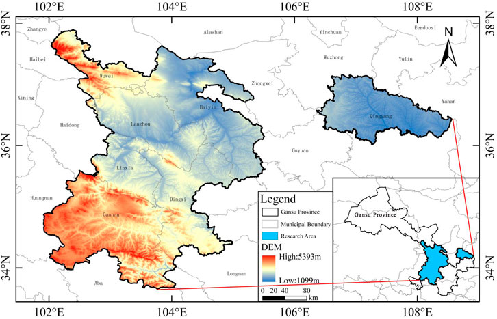
Figure 1. Location of study area.
2.2 Data sources
The primary data used in this study include: 1) LUCC (Land-Use and Land-Cover Change) data: The LUCC data for 1980, 1990, 2000, 2010, and 2020 were obtained from the Resource and Environment Science Data Center of the Chinese Academy of Sciences (http://www.resdc.cn). The overall accuracy of these data exceeds 85% and consists of 25 secondary categories. For this study, in accordance with the national standard “Classification of Current Land Use,” the data were reclassified into six LUCC types: farmland, forest, grassland, water, urban, and bareland (Figure 2). 2) DEM (Digital Elevation Model) and slope data: The DEM data, with a spatial resolution of 30 m, were sourced from the Geospatial Data Cloud (http://www.gscloud.cn), and the slope was derived from the DEM.
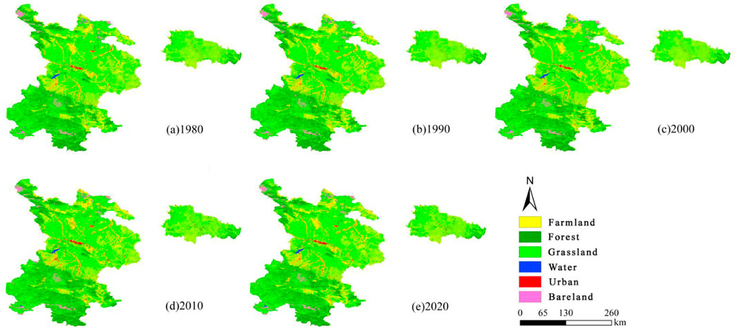
Figure 2. LUCC distribution in the farming-pastoral ecotone of Gansu Province from 1980 to 2020. Note: (A) LUCC distribution in the farming-pastoral ecotone of Gansu Province in 1980. (B) LUCC distribution in the farming-pastoral ecotone of Gansu Province in 1990. (C) LUCC distribution in the farming-pastoral ecotone of Gansu Province in 2000. (D) LUCC distribution in the farming-pastoral ecotone of Gansu Province in 2010. (E) LUCC distribution in the farming-pastoral ecotone of Gansu Province in 2020.
3 Materials and methods
3.1 CA-Markov model
The transitions between land use types over a specified time period are modeled as “possible states” in a Markov process, with the area of these transitions represented as a transfer probability matrix (Karim et al., 2018). The calculation formula is Equation 1:
Where,
In the formula,
3.2 LUCC analysis method
3.2.1 Single dynamic attitude
This method can quantitatively reflect the magnitude and rate of change of each land use type in the study area, thereby facilitating the analysis of the overall change and structural dynamics of land use types (Wang and Bao, 1999). The calculation formula is Equation 3:
Where,
3.2.2 Land use transfer matrix
The GIS database was established to analyze the dynamic changes in land use characteristics within the agricultural-pastoral ecotone of Gansu Province. By employing a land use transition matrix, the areas of conversion among different land use types from 1980 to 2040 can be assessed, thereby reflecting the degree of mutual transformation among various land types during this period (Xie et al., 2010). The calculation formula is Equation 4:
Where,
3.3 Landscape ecological risk district division
To further investigate the spatial distribution patterns of landscape ecological risk, existing methodologies were consulted, and the study area was divided into 3,490 risk zones based on the criterion that the average patch area is 2–5 times larger (Tian et al., 2018). This subdivision was carried out using the fishnet tool within the ArcGIS 10.5 environment, with each zone measuring 5 km × 5 km. Subsequently, the ecological risk index was calculated for each grid, and the results were assigned to the central points of the respective risk zones (Figure 3).
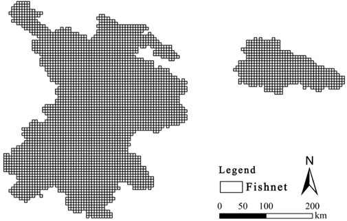
Figure 3. Landscape ecological risk area in the study area.
3.4 Landscape ecological risk index
The ecological risk index of landscape structure types was constructed by using the LUCC data from 1980 to 2020 and the predicted data from 2030 to 2040 (Li et al., 2019). It is used to describe the relative size of comprehensive ecological risks in the region, so as to transform landscape spatial structure into spatial ecological risk variables through sampling method. The calculation formula is Equation 5:
Where,
3.5 Spatial autocorrelation analysis
Spatial autocorrelation analysis quantitatively describes the interdependence among spatial attribute values. The Moran’s I index is one of the most widely used indices in spatial autocorrelation analysis, owing to its broad applicability and versatility. It effectively measures the spatial distribution characteristics of physical or ecological variables and the degree to which they impact the region. Applicable to various types of data and diverse research fields, Moran’s I is crucial for analyzing complex spatial phenomena such as landscape ecological risks. In this study, GeoDa software was used to calculate both global and local Moran’s I indices to quantitatively analyze the degree of spatial autocorrelation and explore the landscape ecological risk aggregation model (Bosso et al., 2017). Global Moran’s I reflects the overall spatial attribute value of the study area, with values ranging from −1 to 1. Moran’s I > 0, <0 and = 0 respectively indicate the spatial distribution of landscape ecological risks in clustered, discrete and random states. Local Moran’s I (
3.6 Topographic gradient analysis
(1) Slope and elevation are two of the most significant topographic factors influencing landscape ecological risk. The Topographic Position Index is a comprehensive index that integrates both slope and elevation attributes. It can effectively reveal the spatial distribution of landscape ecological risk along topographic gradients, addressing the limitations of using a single topographic factor (such as elevation or slope) to reflect landscape ecological risk patterns (Tong et al., 2016). The calculation formula is Equation 6:
Where,
(2) The Topographic Distribution Index method exhibits strong comparability and universality. It can be applied to analyses across different research regions, ecological risk types, and topographic conditions. This index was utilized to describe the distribution characteristics of landscape ecological risk types at various gradient levels of the Topographic Position Index (Gong et al., 2017). The calculation formula is Equation 7:
Where,
3.7 Topographic data classification
To analyze the spatial distribution patterns of landscape ecological risk across different topographic gradients, the elevation, slope, and terrain position in the agricultural-pastoral ecotone of Gansu Province were divided into five levels using the natural breaks method. These levels were then labeled as 1, 2, 3, 4, and 5 based on their respective values (Dorner et al., 2002). As shown in Table 1.
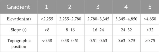
Table 1. Topographic factor gradient classification.
4 Result analysis
4.1 LUCC dynamic simulation
Based on the land use maps from 2000 to 2010, a suitability atlas was constructed, and the CA-Markov model was applied to generate a simulated land use map for 2020. The overall Kappa index between the actual and simulated land use maps for 2020 was 0.84, with an overall accuracy (OA) of 0.863, a user accuracy (UA) of 0.817, and a producer accuracy (PA) of 0.896. These results indicate that both the CA-Markov model and the suitability atlas achieved a relatively high level of accuracy in simulating the various land use types. Furthermore, using the land use maps from 2010 to 2020, spatial data for land use in 2030 and 2040 were successfully predicted.
The primary land use types in the agro-pastoral ecotone of Gansu Province are grassland, followed by farmland and forest, with these three types collectively accounting for more than 95% of the total area (Figure 4). From 1980 to 2040, urban land, bareland, and forest areas exhibited an increasing trend, while the area of water bodies remained relatively stable. Farmland decreased by 1,789.52 km2 over the 60-year period, representing the largest reduction, with substantial conversion into grassland and urban land. Grassland also decreased by 205.17 km2, with the primary conversions occurring to farmland and forest (Figure 5). Urban land expanded by 1,240.90 km2, driven by urban construction and economic development in Gansu. The change in water body area was minimal compared to other land types, with a reduction of 16.82 km2, mainly converted into grassland and farmland.
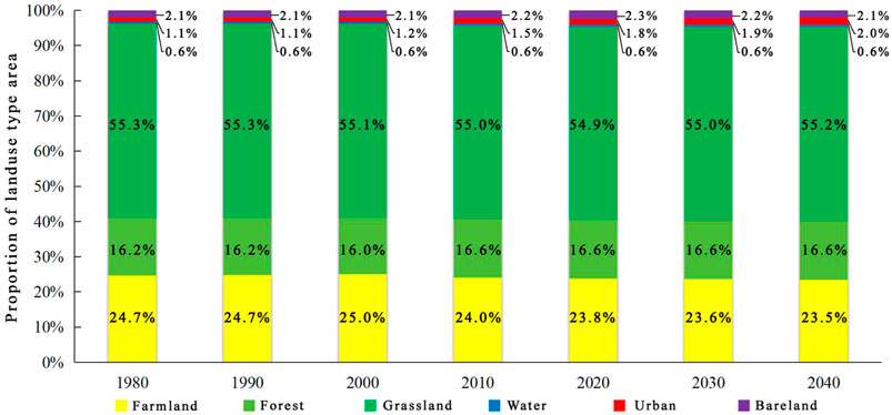
Figure 4. Proportion of land use type area in the farming-pastoral ecotone of Gansu Province.
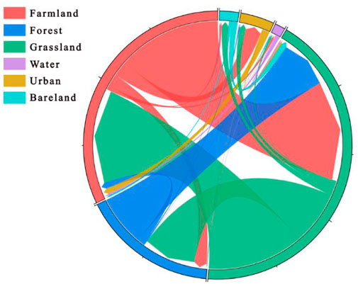
Figure 5. String map of land use transfer in the farming-pastoral ecotone of Gansu Province.
As shown in Figure 6, there are notable differences in the dynamics of land use in the Gansu pastoral-agricultural ecotone across different time periods. From 1980 to 2000, land use changes were relatively slow, with farmland, water bodies, and urban land exhibiting positive growth, particularly urban land, which experienced a rapid increase, while other land use types remained relatively stable. Between 2000 and 2020, water bodies, urban land, and bareland continued to show positive growth, although urban land growth slowed significantly, while forest and grassland areas experienced negative growth. From 2020 to 2040, urban land and water bodies showed a slight but consistent increase, while bareland transitioned to negative growth, and changes in other land types were minimal. Over the 60-year period, grassland showed the least dynamic change. The most pronounced increase was in urban land, with a dramatic rise starting between 2000 and 2020. Bareland also transitioned to negative growth starting in 2020.
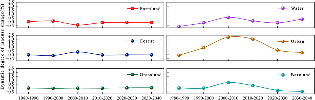
Figure 6. Dynamic stacking map of land use in the farming-pastoral ecotone of Gansu Province.
4.2 Spatial and temporal change analysis of landscape ecological risk
The spatial distribution of ecological risk in the agricultural-pastoral ecotone of Gansu Province shows significant differences, generally following a pattern of lower risk in the southwest and higher risk in the northeast, as illustrated in Figure 7. High-risk areas are concentrated in the central and northern regions of the agricultural-pastoral ecotone, while higher risk and middle risk zones are primarily located in the eastern part of the ecotone. Conversely, lower risk and lowest risk areas are mainly found in the southern region. Specifically, high-risk and higher risk zones are predominantly situated in the western part of Wuwei City, the central area of Linxia Hui Autonomous Prefecture, the northern region of Baiyin City, a small portion of the central area of Gannan Tibetan Autonomous Prefecture, and the northwestern part of Qingyang City. Middle risk areas are primarily located in the northeastern part of Gannan Tibetan Autonomous Prefecture, the northwestern part of Dingxi City, the eastern part of Lanzhou City, the western part of Wuwei City, and some regions in the western part of Baiyin City. Lower risk zones are primarily distributed in most of the central region of Gannan Tibetan Autonomous Prefecture, the eastern part of Lanzhou City, most of the central region of Wuwei City, and the peripheral areas of central Qingyang City. The lowest risk areas are mainly found in the southern part of Gannan Tibetan Autonomous Prefecture, in the districts of Xigu, Anning, Qilihe, and Chengguan in Lanzhou City, parts of Zhongchuan Town, some areas of Baiyin City, the southern part of Wuwei City, and parts of the southern area of Dingxi City.
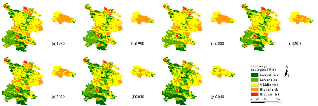
Figure 7. Spatial and temporal distribution of landscape ecological risk in the study area. Note: (A) Landscape ecological risk value in 1980. (B) Landscape ecological risk value in 1990. (C) Landscape ecological risk value in 2000. (D) Landscape ecological risk value in 2010. (E) Landscape ecological risk value in 2020. (F) Landscape ecological risk value in 2030. (G) Landscape ecological risk value in 2040.
Calculating the average values of the Ecological Risk Index (ERI) for each year reveals the following trend: 2040
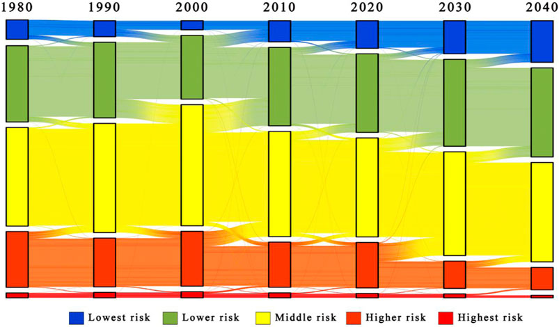
Figure 8. Sankey diagram of landscape ecological risk transfer in the study area.
The artificial landscapes consist of farmland landscapes and urban landscapes, while the natural landscapes include forest landscapes, grassland landscapes, water landscapes, and bareland landscapes. By calculating the spatial distribution and area proportions of ecological risks across different landscape types from 1980 to 2040, the following results were obtained. The ecological risk of artificial landscapes has generally stabilized, with high-risk areas in both farmland and urban landscapes each accounting for less than 2%, while higher risk areas range from approximately 30%–40%. In contrast, the ecological risk of natural landscapes shows a decreasing trend, particularly with significant increases in high-risk areas for forest landscapes, grassland landscapes, and bareland landscapes by the year 2000. Forest and grassland landscapes predominantly exhibit middle-risk areas, followed by lower and higher risk areas. Bareland landscapes are primarily categorized as high and higher risk, with middle risk areas coming next. Water landscapes mainly fall into high, higher, and middle risk categories. The ecological risk values for various land use types, ranked from highest to lowest, are as follows: bareland landscapes > water landscapes > farmland landscapes > urban landscapes > grassland landscapes > forest landscapes (Figure 9).
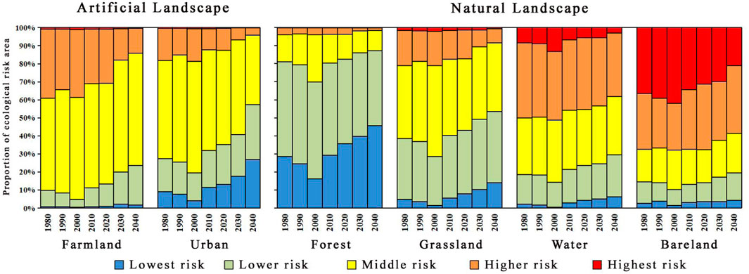
Figure 9. The proportion of ecological risk area in different landscape classes from 1980 to 2040.
The global and local spatial autocorrelation analysis of landscape ecological risks from 1980 to 2040 was conducted. The results indicate that the global autocorrelation index (Moran’s I) for the years 1980–2040 is consistently greater than 0.6, suggesting that high-risk areas are surrounded by corresponding high-risk units, while low-risk areas generally have lower risk levels. Local autocorrelation analysis reveals a regional clustering of landscape ecological risks in the Gansu agricultural-pastoral ecotone between 1980 and 2040, with predominant clustering patterns identified as H-H and L-L. Both H-H and L-L patterns have shown a decreasing trend over the 60-year period. The H-H pattern is primarily distributed in regions such as Baiyin and Qingyang in eastern Gansu, while the L-L pattern is mainly found in the southwestern areas of Gannan and Longnan (Figure 10).
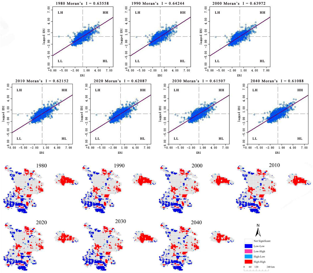
Figure 10. Spatial autocorrelation analysis of landscape ecological risk from 2000 to 2040.
4.3 Landscape ecological risk distribution characteristics based on topographic gradient
The distribution patterns of ecological risk levels in the Gansu farming-pastoral ecotone from 1980 to 2040 showed no significant changes along the topographical gradient. High-risk zones were primarily concentrated in low-lying, flat areas, with an increasing area of high-risk distribution as the elevation gradient rose; the distribution index for high-risk areas was consistently greater than 2. The predominant distribution zones for higher and middle-risk levels were mainly located in mid to high elevation areas, with distribution indices exceeding 1. Conversely, the dominant distribution zones for lower and lowest-risk levels were found in low elevation areas, with distribution indices greater than 1.5. From 1980 to 2040, the distribution index for middle-high risk levels showed a yearly increasing trend in low elevation areas, while the distribution index for middle-high risk levels first rose and then fell in mid to high elevation areas, stabilizing after 2010. The distribution index for lowest-risk levels initially increased and then decreased within the mid-low elevation range, peaking at 2.68 in 2000. In terms of distribution structure, low-risk, lower risk, and high-risk areas were mainly found in the 1–2 elevation range, with lower distribution indices for middle and higher risk levels. In the 3–5 elevation range, the distribution was primarily composed of middle, higher, and high-risk areas, with distribution indices positively correlated with elevation levels, while lower and lowest-risk areas were less represented, with distribution indices below 1 (Figures 11, 12).
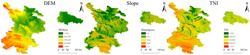
Figure 11. Gradient map of topographic factors.
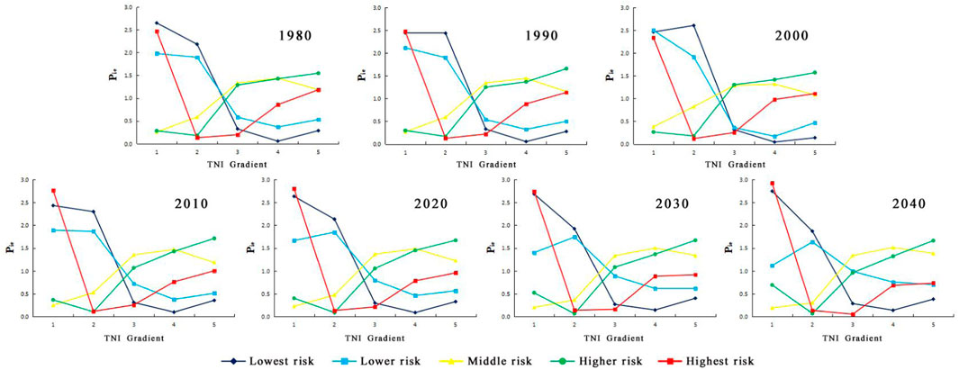
Figure 12. The distribution index of each ecological risk level on the topographic gradients.
5 Discussion
5.1 Landscape ecological risk changes
In the farming-pastoral ecotone of Gansu Province, high-risk, higher-risk, and middle-risk areas are primarily characterized by farmland and urban land. These regions face certain natural limitations, including terrain and soil conditions. For instance, some areas, despite relatively flat terrain, experience soil fertility loss, which undermines the stable maintenance of the natural ecosystem. Human activities exacerbate these challenges. Population growth and urbanization have driven the expansion of built-up land, while unsustainable agricultural practices have further degraded the environment. Consequently, farmland and urban areas have encroached upon other landscape types, leading to inefficient land use patterns and heightened human interference, thereby increasing ecological risks. Since 2010, policies promoting the conversion of farmland to forest and grassland have been implemented, improving the structure and function of ecosystems in these areas. Furthermore, large-scale land consolidation and ecological restoration projects have been pursued in high-risk zones, increasing the land’s ecological carrying capacity. As a result, the ecological risk levels in Gansu’s farming-pastoral ecotone have decreased, reflecting a notable improvement in the region’s ecological environment (Gong et al., 2014).
Middle-risk and lower-risk areas in the farming-pastoral ecotone are mainly characterized by less vulnerable forest and grassland landscapes. This shift can be attributed to the implementation of ecological environment supervision and grassland ecological compensation policies in the Gannan Tibetan Autonomous Prefecture. Behaviors such as overgrazing and illegal reclamation have been strictly restricted, facilitating a transition toward lower-risk zones. The lower-risk areas in the farming-pastoral ecotone are predominantly forest landscapes, where tree roots penetrate deep into the soil, effectively conserving water and preventing soil erosion, which helps regulate water conservation and reduce ecological risks. Since 2010, regions that have transitioned to lower ecological risk zones have adopted policies such as mountain closure for afforestation. These policies, coupled with protected areas and increased forest inspections, have reduced human interference and gradually improved vegetation community structures. In addition, areas such as Gannan and Linxia have transformed their agricultural production methods by promoting ecological and sustainable agriculture in zones surrounding forested areas. This transition has restructured agricultural practices and reduced encroachment on forested land, further improving the ecological environment in regions of middle and lower ecological risk (Li et al., 2018).
In recent years, effective regional ecological protection measures and the deepening of sustainable development concepts have contributed to a general decline in ecological risk in the study area. Artificial landscape patches have maintained a high level of stability due to scientific planning and management, experiencing minimal external interference and primarily exhibiting middle to low risk (Wang et al., 2023). The negative impacts of human activities on natural landscapes have gradually diminished, thanks to ecological restoration projects and environmental protection policies. Specifically, industrial pollution discharge has been effectively controlled, and the use of agricultural chemicals has been reduced, leading to continuous improvements in environmental quality (Zhang et al., 2013). The ecological risk index for landscapes in the farming-pastoral ecotone of Gansu Province shows a significant positive spatial correlation, which provides compelling evidence for the integrity and interconnectedness of the region’s ecosystem. This spatial clustering effect indicates that ecological risks are not isolated; rather, they are interconnected spatially, with high-risk areas being adjacent to other high-risk zones. Consequently, ecological risk prevention and control should not focus solely on individual risk points, but rather consider them within a broader spatial context (Meng et al., 2012). The risk aggregation patterns in the study area are characterized by two primary clusters: H-H and L-L, both of which have exhibited a decreasing trend over the past 60 years. In H-H distribution areas, natural factors challenge ecosystem stability. Complex terrains, such as mountainous and ravine-rich areas, disrupt ecological corridors and hinder species migration and dispersal. Variable climatic conditions, including extreme temperature and precipitation changes, exceed the adaptive capacity of many species, affecting their survival and reproduction. Anthropogenic factors further exacerbate these risks. Over-exploitation of resources, such as mining and logging, and inappropriate land use, such as converting natural habitats into agricultural or urban areas, have damaged ecosystem structures and functions, intensifying ecological risks. In future development, such areas should focus on enhancing the specificity of ecological protection and restoration efforts. In contrast, L-L distribution areas exhibit significant ecological advantages. Extensive grassland landscapes in Gannan and Longnan, coupled with the region’s steep topography, limit human interference. The challenging terrain hinders large-scale development, thus reducing ecosystem damage and resulting in lower risk levels. It is essential to maintain these ecological advantages by strengthening monitoring and protection efforts for natural ecosystems. For example, advanced monitoring equipment can be installed, and the frequency of ecological assessments can be increased. Additionally, development plans should be scientifically sound, ensuring that any utilization of ecological resources is conducted in a manner that does not harm the environment (Yan et al., 2020).
5.2 Effect of topographic gradient on landscape ecological risk distribution
Topographic conditions are one of the primary limiting factors affecting land use and land cover change (LUCC). Given the close relationship between LUCC and ecological issues, the impact of topography on the ecological environment is significant and should not be overlooked. In areas with low topographic position gradients, human activities such as the expansion of built-up land and large-scale agricultural practices are commonly carried out to meet production and living needs. In low topographic position areas, such as river alluvial plains, urban construction and farmland reclamation are frequent, leading to changes in land use and landscape patterns, with various landscape types interspersed across the region. From an ecological perspective, the hydrothermal conditions in low-gradient areas are generally favorable. However, human activities have disrupted the natural ecological balance. For example, wetland destruction has diminished the region’s water regulation capacity, while alterations to soil structure have affected nutrient cycles, leading to an increase in ecological risks and the formation of middle to high-risk zones (Yuan et al., 2020). In areas with lower topographic position gradients, the ecosystem structure is relatively simple, and the processes of energy and material exchange are more stable. Due to the limited terrain undulations, ecological factors such as water, heat, and soil nutrients are distributed more evenly, resulting in greater ecological stability and lower risk levels. In moderate-gradient areas, the dynamics of ecological risk are influenced by both natural and human activities. While the risk of natural disasters is moderate, these areas are more susceptible to geological hazards such as landslides and debris flows compared to high-gradient areas. However, their vulnerability to flooding and other natural disasters is relatively lower than that in low-gradient areas, resulting in the establishment of moderate-risk zones. In high-gradient areas, harsh climatic conditions and poor soil quality weaken the ecosystem’s self-repair capacity, leading to relatively lower ecosystem stability and ecological risk. The rugged terrain in high-gradient areas is characterized by well-developed natural vegetation, with forests and grasslands forming the main landscape features. This continuous vegetation cover acts as a natural ecological barrier, aiding in the stability of material cycling and energy flow within the ecosystem. The roots of vegetation help fix the soil, mitigating soil erosion, while the leaves absorb and convert solar energy, promoting energy flow, resulting in lower ecological risk levels in these areas (Liu et al., 2018). However, the southwestern high-gradient areas of the farming-pastoral ecotone of Gansu Province, despite having extensive grasslands, forests, and bareland, exhibit moderate to high ecological risk due to their inherent vulnerability and fragmentation. Long-term cumulative impacts of environmental changes, such as variations in vegetation growth cycles due to climate fluctuations and extreme weather damage to vegetation, have exacerbated ecological risks in this region. Although human activity in these areas is relatively minimal, the ecological risks primarily stem from challenges posed by natural factors (Shi et al., 2018). Therefore, governance strategies for high-risk areas must be tailored to address their specific causes. In low-gradient areas, land consolidation and ecological restoration projects should be prioritized, focusing on improving ecological functions through measures such as wetland restoration and the reclamation of abandoned land. In areas with high topographic gradients, monitoring and research on the natural environment should be strengthened. Long-term monitoring stations should be established, and specialized research should be conducted to understand the patterns and trends in environmental changes, facilitating the implementation of adaptive management strategies (Wang et al., 2014).
5.3 Limitations and future research directions
This study integrates multiple scientific research methods, including the CA-Markov model, Ecological Risk Index (ERI), and topographic position index, to comprehensively analyze the dynamic evolution patterns and aggregation characteristics of landscape ecological risk along the topographic gradient in the farming-pastoral ecotone of Gansu Province. However, certain uncertainties exist within the research. First, the results of landscape ecological risk assessment heavily depend on the accuracy of land use and land cover change (LUCC) data, which may not be sufficiently detailed in complex terrains and rapidly changing ecological environments. Second, this study focuses solely on the farming-pastoral ecotone of Gansu Province; different regions may exhibit varying ecological characteristics and risk factors, which somewhat limits the generalizability of the findings. Despite these uncertainties, this research still provides theoretical guidance and decision-making support for the sustainable development of the farming-pastoral ecotone in Gansu Province.
6 Conclusion
The evaluation process of landscape ecological risk based on topographic gradients is complex. This study employs land use and land cover change (LUCC) data to construct a landscape ecological risk assessment model, utilizing spatial autocorrelation analysis and topographic distribution index methods to explore the dynamic changes and influencing factors of ecological risk along the topographic gradient. The research findings are as follows:
(1) The primary landscapes in the farming-pastoral ecotone of Gansu Province are grasslands, arable lands, and forests, which together account for over 95% of the total area. In a long-term time series analysis from 1980 to 2040, the areas of built-up land, bare land, and forests have all expanded to varying degrees, while the areas of traditional agricultural and pastoral lands—arable land and grassland—have significantly decreased, reflecting profound changes in land use patterns. The main trend in landscape conversion focuses on the transformation of arable and grasslands into built-up land.
(2) The ecological risk in the farming-pastoral ecotone of Gansu Province exhibits a spatial distribution pattern that is lower in the southwest and higher in the northeast, with overall ecological risk initially increasing and then decreasing. Specifically, the areas of high-risk and higher-risk zones have significantly reduced by more than 50%, reflecting the effectiveness of ecological governance measures. Meanwhile, the area of moderate-risk zones has changed relatively steadily, while the areas of lower-risk and low-risk zones have achieved significant growth, particularly with the area of low-risk zones more than doubling, indicating a positive improvement in the regional ecological condition.
(3) Under different topographic gradients, the landscape ecological risk in the farming-pastoral ecotone of Gansu Province exhibits complex differentiation characteristics with topographic changes. High-risk areas are mainly distributed in regions with low topographic positions that are subject to human activity interference; however, as the topographic gradient increases, the area of high-risk distribution also expands. Low ecological risk is predominantly found in low topographic gradient areas, which show strong spatial correlation and clustering.
(4) The distribution patterns of ecological risk along the topographic gradient are significantly influenced by both human and natural factors. In low topographic areas, human activity becomes the predominant factor contributing to increased ecological risk, while in high topographic areas, significant changes in natural environmental conditions are the primary drivers of heightened ecological risk. Consequently, it is essential to tailor interventions to the specific characteristics of each region. In low-gradient areas where human interference is more pronounced, natural resources should be developed and utilized in a sustainable manner to minimize the disruptions caused by inappropriate production activities and human interventions. In regions with high-gradient topography, policies such as mountain closure for afforestation should be prioritized to mitigate the negative impacts of natural environmental changes, with the aim of promoting the sustainable and healthy development of the farming-pastoral ecotone in Gansu Province.
Data availability statement
The original contributions presented in the study are included in the article/supplementary material, further inquiries can be directed to the corresponding author.
Author contributions
LY: Data curation, Formal Analysis, Methodology, Software, Writing–original draft. JY: Conceptualization, Funding acquisition, Project administration, Writing–review and editing. GL: Conceptualization, Funding acquisition, Writing–review and editing. WM: Conceptualization, Writing–review and editing. TL: Conceptualization, Writing–review and editing. PG: Data curation, Writing–review and editing. QL: Data curation, Writing–review and editing. XY: Writing–review and editing. JL: Writing–review and editing. WW: Writing–review and editing.
Funding
The author(s) declare that financial support was received for the research, authorship, and/or publication of this article. This work was sponsored in part by National Natural Science Foundation of China (42461060); Gansu Province Key Research and Development Program Project (24YFFA059); Gansu Province 2024 Central Government-Guided Local Science and Technology Development Fund Project (24ZYQA023); Gansu Province Department of Education Industry Support Program Project (2022CYZC-41); Gansu Province Financial Special Fund (GSCZZ 20160909).
Conflict of interest
The authors declare that the research was conducted in the absence of any commercial or financial relationships that could be construed as a potential conflict of interest.
Generative AI statement
The author(s) declare that no Generative AI was used in the creation of this manuscript.
Publisher’s note
All claims expressed in this article are solely those of the authors and do not necessarily represent those of their affiliated organizations, or those of the publisher, the editors and the reviewers. Any product that may be evaluated in this article, or claim that may be made by its manufacturer, is not guaranteed or endorsed by the publisher.
References
Bosso, L., De Conno, C., and Russo, D. (2017). Modelling the risk posed by the zebra mussel Dreissena polymorpha: Italy as a case study. J. Environ. Manag. 60 (2), 304–313. doi:10.1007/s00267-017-0882-8
Cui, L., Zhao, Y., Liu, J., Han, L., and Yin, S. (2018). Landscape ecological risk assessment in Qinling Mountain. Geol. J. 53 (1), 342–351. doi:10.1002/gj.3115
Dorner, B., Lertzman, K., and Fall, J. (2002). Landscape pattern in topographically complex landscapes: issues and techniques for analysis. Landsc. Ecol. 17, 729–743. doi:10.1023/a:1022944019665
Faichia, C., Tong, Z., Zhang, J., Liu, X., Kazuva, E., Ullah, K., et al. (2020). Using RS data-based CA–Markov model for dynamic simulation of historical and future LUCC in Vientiane, Laos. Sustainability 12 (20), 8410. doi:10.3390/su12208410
Gong, J., Zhao, C. X., Xie, Y. C., and Gao, Y. J. (2014). Ecological risk assessment and its management of Bailongjiang watershed, southern Gansu based on landscape pattern. Chin. J. Appl. Ecol. 25 (7), 2041–2048. doi:10.13287/j.1001-9332.20140425.005
Gong, W. F., Wang, H. B., Wang, X. F., Fan, W. Y., and Stott, P. (2017). Effect of terrain on landscape patterns and ecological effects by a gradient-based RS and GIS analysis. J. For. Res. 28 (5), 1061–1072. doi:10.1007/s11676-017-0385-8
Hou, M. J., Ge, J., Gao, J. L., Meng, B. P., Li, Y. C., Yin, J. P., et al. (2020). Ecological risk assessment and impact factor analysis of alpine wetland ecosystem based on LUCC and boosted regression tree on the zoige plateau, China. Remote Sens. 12 (3), 368. doi:10.3390/rs12030368
Ispikoudis, I., Lyrintzis, G., and Kyriakakis, S. (1993). Impact of human activities on Mediterra nean landscapes in western Crete. Landsc. Urban Plan. 24, 259–271. doi:10.1016/0169-2046(93)90105-m
Karimi, H., Jafarnezhad, J., Khaledi, J., and Ahmadi, P. (2018). Monitoring and prediction of land use/land cover changes using CA-Markov model: a case study of Ravansar County in Iran. Arabian J. Geosciences 11 (19), 592–599. doi:10.1007/s12517-018-3940-5
Lange, H., Sala, S., Vighi, M., and Faber, J. H. (2010). Ecological vulnerability in risk assessment—a review and perspectives. Sci. Total Environ. 408 (18), 3871–3879. doi:10.1016/j.scitotenv.2009.11.009
Leuven, R., and Gne, I. P. (2010). Riverine landscape dynamics and ecological risk assessment. Freshw. Biol. 47 (4), 845–865. doi:10.1046/j.1365-2427.2002.00918.x
Li, Q. P., Zhang, Z. D., Wan, L. W., Yang, C. X., Zhang, J., and Ye, C. (2019). Landscape pattern optimization of Ningjiang River Basin Based on landscape ecological risk assessment. Acta Geogr. Sin. 074 (007), 1420–1437. doi:10.11821/dlxb201907011
Li, Y. Y., Huang, Y. X., Yang, Y., and Ye, G. F. (2018). Land use change and its impact on ecological risk in Changting County, Fujian Province. Ecol. Sci. 037 (006), 52–59. doi:10.13961/j.cnki.stbctb.2018.04.039
Liang, L., Sun, Y., Guan, Q., Pan, N., Du, Q., Mi, J., et al. (2023). Projection of landscape ecological risk and exploration of terrain effects in the Qilian Mountains, China. Land Degrad. Dev. 34 (15), 4575–4593. doi:10.1002/ldr.4794
Liu, D., Liang, X., Chen, H., Zhang, H., and Mao, N. (2018). A quantitative assessment of comprehensive ecological risk for a loess erosion gully: a case study of Dujiashi Gully, Northern Shaanxi province, China. Sustainability 10 (9), 3239. doi:10.3390/su10093239
Liu, Q., Wang, H. W., and Gong, L. (2014). Evaluation of ecological security and evolution trend of weigan kuqa river oasis in xinjiang. Soil Water Conservation Res. 21 (2), 179. doi:10.13869/j.cnki.rswc.2014.02.033
Lu, Y. L., Li, G., Yan, L. J., Dong, L. X., Li, J., Nie, Z. G., et al. (2021). Study on the change of precipitation in agro-pastoral ecotone of Gansu province from 1971 to 2019. Acta Agrestia Sin. 29 (11), 2556. doi:10.11733/j.issn.1007-0435.2021.11.022
Ma, S. B., An, Y. L., Yang, G. B., and Zhang, Y. R. (2019). Vegetation change trend and cause analysis on different terrain gradients. Acta Ecol. Sin. 028 (005), 857–864. doi:10.16258/j.cnki.1674-5906.2019.05.001
Meng, X., Ren, Z. Y., and Zhang, D. (2012). Land use change and ecological risk in Xianyang city. Arid area Res. 29 (1), 137–142. doi:10.13866/j.azr.2012.01.006
Shi, Y., Yuan, D. P., Zhao, X. S., Feng, Q., Niu, Z. J., and Wang, S. T. (2018). Ecosystem service value assessment of jianshan basin in northwest hebei province based on terrain gradient: a case study of huailai county, hebei province. Soil water conservation Res. 25 (3), 184–190. doi:10.13869/j.cnki.rswc.2018.03.026
Tian, P., Li, J. L., Shi, X. L., Wang, L. J., and Liu, R. Q. (2018). Spatial and temporal change of land use pattern and ecological risk assessment in Zhejiang Province. Resour. Environ. Yangtze River Basin 27 (12), 59–68. doi:10.11870/cjlyzyyhj201812006
Tong, X., Wang, K., Brandt, M., Yue, Y., Liao, C., and Fensholt, R. (2016). Assessing future vegetation trends and restoration prospects in the karst regions of southwest China. Remote Sens. 8 (5), 357. doi:10.3390/rs8050357
Wang, C., Zhen, L., Du, B. Z., and Sun, C. Z. (2014). Empirical analysis on the implementation effect of returning farmland to forest and grassland project in typical areas of Loess Plateau. Chin. J. Ecol. Agric. 22 (7), 850–858. doi:10.3724/SP.J.1011.2014.30944
Wang, M. J., Wu, Y. M., Wang, Y., Li, C., Wu, Y., Gao, B. P., et al. (2023). Study on the spatial heterogeneity of the impact of forest land change on landscape ecological risk: a case study of erhai rim region in China. Forests 14 (7), 1427. doi:10.3390/f14071427
Wang, X. L., and Bao, Y. H. (1999). Study on the methods of land use dynamic change research. Prog. Geogr. Sci. 018 (001), 81–87.
Xie, Y. W., Liu, Z. G., Zhao, J., Li, Y., and Zhang, L. (2010). Land use change analysis of typical black soil area based on RS and GIS: a case study of hailun city. Geoscience 30 (3), 428–434. doi:10.13249/j.cnki.sgs.2010.03.020
Xue, L., Zhu, B., Wu, Y., Wei, G., Liao, S., Yang, C., et al. (2019). Dynamic projection of ecological risk in the Manas River basin based on terrain gradients. Sci. total Environ. 653, 283–293. doi:10.1016/j.scitotenv.2018.10.382
Yan, Y. Y., Yang, L., Wang, W. S., Fang, H., and Zhuang, Q. W. (2020). Analysis of spatial and temporal changes of landscape ecological risk and its terrain gradient in Yili River Valley. Ecol. Sci. 39 (04), 125–136. doi:10.14108/j.cnki.1008-8873.2020.04.017
Yang, Y., Hasi, E., Du, H. S., Sun, B. P., Zhao, Y., and Zhao, R. (2014). Impact of land use change on ecosystem service value in Yanchi County of Ningxia Based on RS and GIS. Soil water conservation Res. 21 (5), 100–105. doi:10.13869/j.cnki.rswc.2014.05.018
Yuan, Y., Fang, G. H., Lu, C. X., and Yan, M. (2020). Flood risk assessment in the context of urbanization based on landscape ecology. J. Geogr. 75 (09), 127–139. doi:10.11821/dlxb202009008
Zhang, J., and Ren, Z. (2016). Spatiotemporal pattern and terrain gradient effect of land use change in Qinling-Bashan mountains. Trans. Chin. Soc. Agric. Eng. 32 (14), 250–257. doi:10.13869/j.cnki.rswc.2014.05.018
Keywords: topographic gradient, farming-pastoral ecotone of Gansu province, landscape ecological risk, topographic position index, autocorrelation analysis
Citation: Yang L, Yan J, Li G, Ma W, Li T, Gao P, Li Q, Yao X, Li J and Wang W (2025) Dynamic simulation of landscape ecological risk in Gansu’s farming-pastoral ecotone based on topographic gradients. Front. Environ. Sci. 13:1523892. doi: 10.3389/fenvs.2025.1523892
Received: 06 November 2024; Accepted: 02 January 2025;
Published: 15 January 2025.
Edited by:
Penghai Wu, Anhui University, ChinaReviewed by:
Muyi Huang, Anhui Jianzhu University, ChinaJinghu Pan, Northwest Normal University, China
Copyright © 2025 Yang, Yan, Li, Ma, Li, Gao, Li, Yao, Li and Wang. This is an open-access article distributed under the terms of the Creative Commons Attribution License (CC BY). The use, distribution or reproduction in other forums is permitted, provided the original author(s) and the copyright owner(s) are credited and that the original publication in this journal is cited, in accordance with accepted academic practice. No use, distribution or reproduction is permitted which does not comply with these terms.
*Correspondence: Jixuan Yan, eWFuaml4dWFuZEBzaW5hLmNvbQ==