 Dana K. Shokparova
 Mukhabat Sirazhitdinova
 Sanim B. Bissenbayeva
 Nilanchal Patel
- 1Department of Geography, Land Management and Cadaster, Al-Farabi Kazakh National University, Almaty, Kazakhstan
- 2China-Kazakhstan Joint Laboratory for Remote Sensing Technology and Application, Al-Farabi Kazakh National University, Almaty, Kazakhstan
- 3Department of Remote Sensing, Birla Institute of Technology Mesra, Ranchi, Jharkhand, India
Agricultural practices in Kazakhstan exert considerable pressure on the landscape, leading to environmental degradation, pastureland fragmentation, and biodiversity loss. Sustainable land management is crucial for balancing economic development and ecological preservation. This study assesses land conditions in the Zhanaarka region of Ulytau Oblast, Kazakhstan, focusing on climatic and anthropogenic impacts. Using Landsat 5 and 8 satellite imagery (2009, 2013, 2018), we evaluated land cover changes through NDVI analysis, climate factor assessment (temperature and precipitation), and GIS-based mapping. Pearson’s correlation and multivariate analysis were applied to identify relationships between vegetation dynamics and climatic variables, alongside anthropogenic influences such as land development and irrigation. Significant shifts in vegetation cover and land boundaries were observed over the study period. Multivariate analysis revealed no single climatic variable (temperature or precipitation) as a limiting factor for Normalized difference vegetation index (NDVI) changes. However, anthropogenic activities, including unsustainable land use, were key drivers of pasture degradation. The findings highlight the dominant role of human activities in land degradation, despite the region’s climatic vulnerabilities. The study underscores the need for integrated land-use policies to mitigate degradation and promote sustainable agricultural practices. Recommendations are provided to enhance resilience against climate change and anthropogenic pressures.
1 Introduction
Global land use system has undergone significant transformations due to various processes such as increasing areas of housing and agricultural use (Foley et al., 2011; Chouari, 2024), and land degradation resulting from erosion, and desertification. As Usievich (2017) noted, about a quarter of the favorable lands were lost in the last century. The high development of livestock and agriculture in the twentieth century has increased the concern for reducing land degradation. Given the rapid development of land deforestation, countries face the challenge of significantly reducing per capita cultivation of land, while the pressure on them is constantly increasing (Gupta, 2019). According to a report by the United Nations Convention to Combat Desertification, over half of the world’s agricultural land is experiencing moderate to severe degradation, leading to a reduction in arable land (Vicente-Serrano et al., 2024). The United Nations’ projected scenario for the year 2025 shows that one in five people will be living on land that is vulnerable to drought. In 2017, more than 2 billion hectares of fertile land on Earth were degraded. By 2024, the rate of degradation is expanding by 1 m sq km worldwide. As shown in the report of the United Nations Convention to Combat Desertification (UNCDD), the rate of degraded land has already reached 15 million square kilometres (Watts, 2024). Land degradation has a negative impact on 3.2 billion people on the planet, and it is safe to say that there is not a single continent that is not affected by this problem (Health, 2018). The countries affected are those whose main activity is agriculture. Neglecting and shortening crop rotations and overuse lead to deterioration of soil quality, loss of organic matter, reduction of plants and limiting their growth. However, the impact of people’s lack of knowledge about environmentally sound land management and other factors that lead to degradation should also be noted (Kirby and Landmark, 2011).
This issue is also relevant to Kazakhstan, where 40% of the land is used for agriculture and has a high value of pastures, arable land and fodder markets for livestock feeding (Robinson and Petrick, 2024). Kazakhstan has a significant socio-economic impact from land degradation which has started from extensive agricultural expansion in the 1950s based on the Virgin Land Programme (Tselina) (Durgin Jr, 1962; Brezhnev, 1979; McCauley, 1976). According to recent studies, more than 75% of Kazakhstan’s land area is considered to be desertification-sensitive areas of moderate and higher sensitivity (Issanova et al., 2020), covering about 3.8% of the total land area, mainly distributed over seven oblasts in western, northwestern and south western Kazakhstan (Hu et al., 2020). Extensive and intensive human activities related to agriculture and livestock raising in the two main desertification zones in northern Kazakhstan have contributed to desertification to some extent. According to the “Sustainable management of pasture resources. Desertification and land degradation is a global problem” project pasture lands cover 188 million hectares (70%) of the area of the country. 77% of pasture is in the plains, 25% - is sand, 18% - low mountainous, foothills, and 5% - valley, lowlands. Due to the unreasonable land use and its climatic characteristics, ERA-NET supported programme RURAGRI has found that most of the land is threatened (country’s livestock per hectare index is 0.29). According to the study, the country has degraded land accounts for more than 15% of the country’s land area, i.e., 27.1 million hectares. This is mainly due to the system, which has been based on the free and unsystematic traditional way of grazing the livestock (Zhou et al., 2005; Kioko et al., 2012).
The study of landscape dynamics in arid regions is of particular importance for understanding the main threats that arise in arid ecosystems. Livestock farming contributes significantly to desertification, necessitating new approaches to land management to mitigate future food shortages threatening millions, particularly in developing countries, within one to two decades (Hamidov et al., 2016; Rahaman et al., 2021). This problem mainly affects cultivated and irrigated land, but grazing land must also be considered. In 2018, the natural pastures in Kazakhstan have counted around 180.4 million hectares, where more than 3% of them are improved, while around 60% are affected by waterlogging. This leaves a total of about 111.2 million hectares of land suitable for livestock grazing. Notably, more than 80% of livestock is concentrated in private herds, most of which graze within 5–7 km of settlements (Summary analytical report for 2017, 2018).
This work reflects the main issues raised in the XXI century agenda adopted by the 1992 UN Conference in Rio de Janeiro, and in the 2012 General Assembly resolution “increasing agricultural productivity… diversify, increase efficiency, achieve food security… minimizing threats to the ecosystem and transfer of environmentally sound technologies… including conservation and sustainable use,” SD Agenda for the period up to 2030, Laws of Kazakhstan and regional development plans.
Today, the Government of Kazakhstan is engaged in the development of the livestock sector with increased production volume, efficiency, and profitability. It is closely linked to the strategy of the Ministry of Agriculture of the Republic of Kazakhstan, which has a target of 15 million head of cattle, in part through the improvement of land quality (Vidyanova, 2021). Analysing previous studies, we concluded that all studies on the development of the agro-industrial complex (AIC) and regulation issues in Kazakhstan, conducted since independence of the country aimed to develop only an economic mechanism for resource management (Suimuhanov et al., 2019). A mechanism based on a combination of state regulation and market self-regulation (Lapova, 2013; Dulambaeva et al., 2014; Idrisova et al., 2017) pursuing a balanced price and financial and credit policy and creating a network of farms with the purchase of cattle (Umbitaliyev, 2013). As found in scientific databases the extensive research on Kazakhstan was focused on various aspects of climate’s impact on the agricultural sector (Islyami et al., 2020; Yu et al., 2020; Karatayev et al., 2022; Wang et al., 2022; Bolatova, 2023), the spread of drought (Sayat et al., 2025), the evaluation of land resources for crop cultivation (Shmelev et al., 2021), and mapping of abandoned agricultural lands using satellite remote sensing (Löw et al., 2015). Research on pasture resources and their degradation level also has been conducted, particularly in the Akmola region (Spaeth et al., 2025), West Kazakhstan Region (Nasiyev et al., 2022; Yesmagulova et al., 2023), Balkhash area (Lebed et al., 2012), Northern Kazakhstan (Stybayev et al., 2021) and other areas, except the Central Kazakhstan. It is worthy of note that a paucity of scientific research has been conducted on issues of agricultural land management, with particular attention paid to landscape features and their impact on the development of the agro-industrial complex of Kazakhstan. Furthermore, there has been a dearth of research conducted in central Kazakhstan.
With the development of industry, agriculture, and transport in Ulytau Oblast, where located case study region Zhanaarka, the problem of land degradation is growing. The Ulytau Oblast is an administrative division of Kazakhstan, situated in the country’s central region. The region receives minimal precipitation, rendering it susceptible to drought, which is the primary driver of severe land degradation. In recent years, the combined effects of climate change and human activities have resulted in alterations to the climatic and human factors that influence vegetation and the environment. The idea of the research lies in the assessment of pastureland in Central Kazakhstan in the example of Zhanaarka region, based on climate and space monitoring for the years 2009, 2013, and 2018. Evaluation of the land conditions needs identifying changes in land boundaries, NDVI vegetation indices, correlation calculation between different indicators and RS data. The use of ecological mapping for assessing land resources will enable the determination of the condition of agricultural land within the research area.
Specific agricultural and industrial regulations need to be implemented to prevent and manage land desertification. The desertification mapping framework developed in this paper can be applied in other regions globally. The findings regarding the driving factors of desertification offer valuable insights for government authorities in Kazakhstan.
2 Materials and methods
2.1 Study area
The Zhanaarka region of Ulytau Oblast was selected for the present study. It is located on the border of the Kazakh Uplands and the Bethpakdala Desert at 46°00′ to 49°22′ north latitude and to 70°07′ to 70°35′ east longitude (Figure 1).
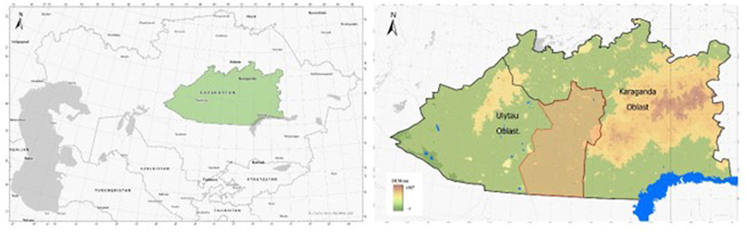
Figure 1. Geographical location and topography of study area.
It should be noted that after the adoption of the Resolution of the Government of the Republic of 2022 the Karaganda region was divided into the Ulytau Oblast (Adilet, 2022). The reduction of the territory resulted from the transfer of the Zhanaarka and Ulytau Oblasts to the Ulytau Oblast. Data until 2022 corresponded to the territory of Karaganda Oblast in this respect. The geographical location and the vastness of the Ulytau Oblast explain the significant difference in climatic conditions. A continental and dry climate characterizes the area. Annual precipitation ranges from 130–310 mm. However, each district has relatively different indicators. For example, in the warm period in the northeast of the country, the average precipitation is up to 270 mm, while in the south (in the desert zone), it is only 65–80 mm.
The reason for choosing the area is livestock, which depends on climatic and physical-geographical characteristics. The study area is mainly comprised of desert, semi-desert, and mountainous regions. The territory of the region is in the mountainous part of the Saryarka and has a continental climate, which is characterized by cold and harsh winters and hot and dry summers. Zhanaarka Region is located in the mountainous, desert and semi-desert areas of the centre of Kazakhstan and has various features of land cover. The district accommodates numerous agricultural entities, comprising over 800 farms and several cooperatives. Currently, approximately 1.38 million hectares of pastureland are actively utilised, with around 72% remaining as reserve due to inactivity. This district was selected for the study as livestock production constitutes the primary agricultural activity in the area, influenced by its climatic and physiographic characteristics. The district encompasses extensive pasturelands, which comprise a significant portion of the total land area, estimated at approximately 6.2 million hectares, of which nearly 4.9 million hectares are designated as pastureland.
2.2 Data sources and data processing
Currently, to analyse the changes data collected from various data-sources. The ecological condition of the Zhanaarka region was evaluated based on the specific characteristics of vegetation cover, physical and geographical location, climatic data, and anthropogenic influence on the territory. In 2009, 2012 and 2018, maximum drought indicators were recorded in the territory of Kazakhstan, predominantly affecting these areas. In order to assess the state of land resources in the study region, these periods were selected in order to identify the relationship between the quality of vegetation cover and climatic impact. Space images for 2009, 2013 and 2018 were selected due to their quality and availability of data for the study region. Agricultural land use data of the Zhanaarka region for 2009 were analysed to determine the state of the land and its valuation, and characteristics of agricultural land in 2013 and 2018 with open data provided by the Statistics Committee of the Ministry of National Economy of the Republic of Kazakhstan (MNE RK). Climatic data such as a temperature and precipitation were obtained from three weather stations located in the research area from the site rp5.ru (http://rp5.kz). Landsat 7 and 8 images retrieved from the US Geological Survey (www.usgs.gov) with spatial resolution 30 m. Pearson’s Correlation was applied to determine between the main factors influencing the state of the land, i.e., temperature and precipitation. Framework for this study is shown in the Figure 2. Attribute information of datasets used in this study is presented in Table 1, which contains the information that was important for the study to be conducted.
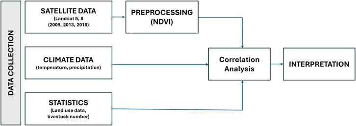
Figure 2. Framework diagram for this study.
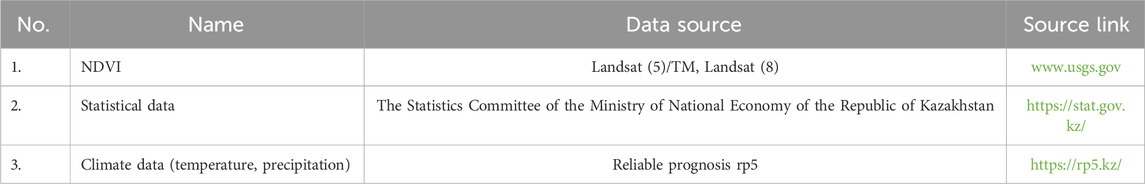
Table 1. Dataset’s information used in the study.
The research was performed using the NDVI, which the is one of the indicator for assessing the condition of vegetation coverage (Huete et al., 2002; Löw et al., 2015). NDVI measures the quantity of photosynthetic active biomass (Tokareva, 2010). It is considered one of the most accurate indices to quantify vegetation cover. The NDVI formula assesses vegetation health by comparing the difference between the reflection of near-infrared (NIR) and red light (RED), normalized by their combined values. It indicates that the vegetation density (NDVI) at a given pixel is determined by dividing the difference between the reflected red and infrared light intensities by the sum of those intensities. NDVI ranges between −1 and 1; the NDVI values of some specific land use and land covers.
As for Landsat 5 bands 4 (NIR) and 3 (RED) and for the Landsat 8 bands 5 (NIR) and 3 (RED) separately.
The correspondence between the NDVI index and the land cover type (by quality and type of vegetation cover). It should also be noted that the greater the value of the infrared reflectance, the greater the value of the NDVI index, which also represent the “greenness” indicator with healthy canopy (Caccamo et al., 2011). This allows the analysis of the index to further determine the quality and type of vegetation.
Correlation analysis is another equally important method in the study of land degradation, which shows the impact of climate on one of the most important factors on land degradation. Pearson’s Correlation helps to compare one data object with another, attribute by attribute (Berman, 2016). The relationship is determined between the following factors: temperature, precipitation, and NDVI.
Correlation is the relationship between two variables (Filandysheva, 2015). The values range from −1 to +1, with +1 indicating a strong link and 0 a weak link (Table 2). A negative correlation coefficient indicates the opposite: the higher the value of one variable, the lower the value of the other. An absolute value of the coefficient of correlation can also characterize the strength of the link.
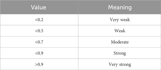
Table 2. The correlation coefficient values ranges.
Using the previously mentioned methods, which include vegetation sensitivity analysis with NDVI, researchers construct maps of healthy vegetation. Based on these maps, they calculate the healthy vegetation status of the area, dividing it into three categories: healthy, transitional, and unhealthy vegetation types.
3 Results and discussion
3.1 NDVI trend and land-cover status
The vegetation conditions index by NDVI was calculated (Figure 3). Landsat 5 and 8 images were selected to analyse vegetation patterns in the study area. NDVI images of 2009, 2013, and 2018 were classified into three categories - healthy vegetation cover, unhealthy vegetation cover, and land with transitional vegetation for improved discrimination and analysis.
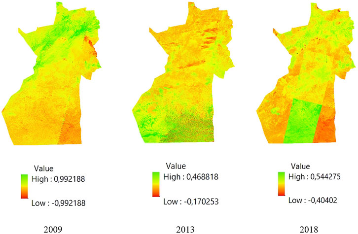
Figure 3. NDVI images of 2009, 2013 and 2018.
The analysis of vegetation conditions over the selected time period reveals that the NDVI index fluctuates. In order to identify the healthy vegetation cover in the Zhanaarka region was designed a map with highlighted (Figure 4).
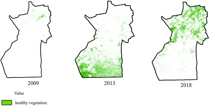
Figure 4. Healthy vegetation of the Zhanaarka region for 2009, 2013, and 2018.
The images illustrate the condition of the land, which was particularly vulnerable to fluctuations in 2009 due to the lower temperatures recorded at all three weather stations. In 2018, an improvement in vegetation health resulted in a significant increase in the cattle population by approximately 40% and a noteworthy rise in the horse population of over 100%. The district possesses a considerable stock of forage, estimated at around 150,000 tonnes, which is sufficient to support livestock production. Yields fluctuate from small plots to 3 ha, contingent upon weather conditions, necessitating grazing in remote areas due to limited vegetation and the fragmentation of seasonal pastures. Farmers manage an area exceeding 1 million hectares of pastureland, whilst some non-state agricultural entities oversee several hundred thousand hectares.
Autumn pastures are extremely important for animal husbandry. During the autumn regrowth, the gross harvest increases, and the quality improves. During 9 years, land degradation increased by 1,502,900 ha, affecting the count of livestock (Table 3).
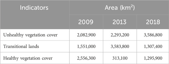
Table 3. Status of land in the Zhanaarka region.
3.2 Impact of climate and livestock farming on land degradation
Climate is one of the important factors influencing degradation. As noted A correlation analysis using wind, precipitation, and NDVI data was carried out to determine the impact of climate in the study area. Similar work has already been carried out in regions of the west part of Kazakhstan (Kіshіbekova and Koshіm, 2016).
In the study area, a weak correlation is noted. The annual average of the correlation coefficient is generally very weak (Table 4).
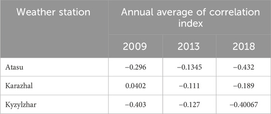
Table 4. Average annual correlation.
A correlation coefficient value below 0.5 indicates an insignificant impact of meteorological factors on land degradation. While climate plays a crucial role, in agricultural areas, climatic data are generally not the primary limiting factor for vegetation cover (Akhter and Afroz, 2024). Vegetation dynamics are also influenced by seasonal variations (Coetzee, 2022), while land cover and land use play a significant role in determining productivity (Guo et al., 2021; Zhang et al., 2021; Wei et al., 2022; Behifar et al., 2023). The results of the correlation and regression analysis indicate that neither high temperatures nor low precipitation were the primary drivers of land degradation in the study area.
The primary type of agricultural activity in the study area is animal husbandry which consist of 75%. As evidenced by the large number of farms (821), peasant farms, and other enterprises engaged in animal husbandry. Taking into account this factor and the location of this territory, which is situated at the intersection of the Kazakh Upland and the Betpak-Dala Desert, this also contributes to the low soil quality (fertility) and a scarcity of vegetative cover. The climate, terrain, soil type, and grazing vegetation greatly impact livestock husbandry. Most cereals and herbs grow at an average daily temperature of 3°C–5°C, and heat-loving plants at a higher temperature. The beginning of the growth of all plants falls, in particular, in the middle and end of April, which is also the beginning for grazing animals in pastures. The most unfavourable period of sheep grazing is winter due to snow cover, icing, strong winds, and low temperatures. The most favourable period for sheep grazing is in spring and autumn. Due to burnout, vegetation loses all its useful properties during the summer. It is during the autumn period during which it is possible to determine the entire nutritional value of pastures. Under favourable weather conditions, namely warm and wet autumn, the gross harvest is increased, and the quality of plants is improved The optimal grazing period for cows on pastures extends from late April until autumn, with the transition to housing occurring 15 days before the first frost (Titova, 1978). Using this information, the Maslikhat of Zhanaarka region’s approved management and utilisation plan for 46 pastures in 2018–2019 was analysed.
Under this plan, rules for grazing livestock in the territory of Karaganda Oblast were approved. Based on the regulation, the procedure for grazing livestock was approved. In Chapter 2, it was noted that “Agricultural animals belonging to natural and legal persons, regardless of the form of ownership, are subject to accounting and registration.” Grazing occurs in fenced or unpaved pastures by owners or authorized persons. Due to natural and climatic conditions, grazing is allowed in fenced or unpaved pastures. There is a ban on grazing animals that have not undergone vaccination and veterinary procedures and sick animals, as well as in areas of common use and water protection zones (Qoldau, 2022). The addition of road, rail, river, and settlement data to the NDVI analysis showed that land near rivers and human settlements suffered significant degradation.
The latest data is entered into the “Supervision Technology database. Digital monitoring of land” (Qoldau, 2022) showed that the number of pastures in Kazakhstan is 100647 with an area of 38,154,095.82 ha, of which 47.15% belong to the Ulytau Olast (including Karaganda), where 722,288.48 ha of land lie in the Zhanaarka region (Table 5).
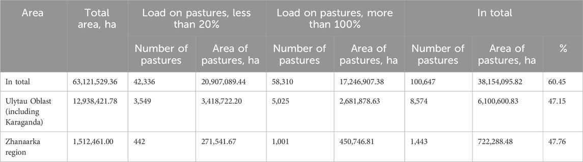
Table 5. Statistics on irrational grazing lands, January 2021 (Qoldau, 2022).
The Oblast region comprises 8,982,777 ha of pasture land and 10,427 ha of unused land. For greater clarity, the ground load was divided into five steps, from low to high pressure (Table 6).
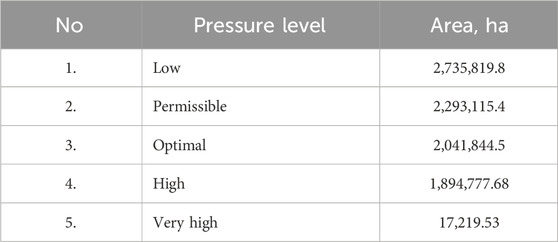
Table 6. Pressure on grasslands (Qoldau, 2022).
The physical geographical location of the region influences the predominance of pastures in the Zhanaarka region. From 2009 to 2017, a significant increase in livestock was observed in the area. The number of cattle increased by 17.2 thousand heads and horses by 28.5 thousand heads. Nevertheless, sheep and goats increased by 18.2 thousand by 2013. This increase was one of the reasons for the deterioration of land in the region (Table 7).
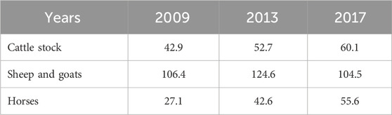
Table 7. Number of livestock, in thousands of head (Qoldau, 2022).
Thus, it can be concluded that animal husbandry, occupying 75% of the farms in the region, is one of the main causes of degradation.
According to the latest data from the Bureau of National Statistics of the Republic of Kazakhstan, published in the analytical report dated 4 April 2024, a study was conducted through collaboration with JSC “NC CGS” on space monitoring of crop production to assess the state of vegetation health. The study calculated pasture areas based on vegetation cover conditions across various regions and cities of national significance (Table 8).
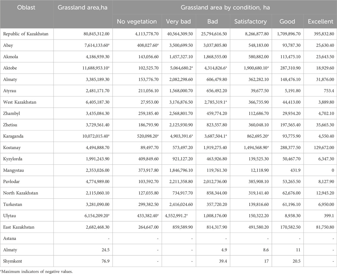
Table 8. Areas of pasture lands by state, in ha (Analytical Material, 2024. Space monitoring data on crop production).
The data indicates that the largest areas of pasture are found in three regions: Aktobe (15%), Karaganda (13%), and Abay (9.4%). Karaganda Oblast alone accounts for over 520,000 ha of land with no vegetation. Additionally, the regions with the poorest vegetation indicators are Ulytau and Karaganda Oblasts, where “very bad” and “bad” conditions are most prevalent.
The study revealed that the main causes of land degradation in pastures are abandonment, overgrazing of livestock, and cutting of shrubs. Over-grazing of land may include areas near villages, but common pastures are more affected. Among other things, cattle grazing is carried out throughout the year in one place. In order to achieve this, it is necessary for the land users to adhere strictly to scientifically based crop rotation systems. Unfortunately, this is not being done properly. For example, a land user’s commitment to crop rotation is part of the land lease agreement. However, in the absence of effective monitoring mechanisms, this has essentially remained on paper. The limited number of staff and technical equipment of the local land inspectorate did not make it possible to solve the control problem. The hope was to be found in the widespread introduction and application of modern digital technologies, in particular space surveillance and the remote sensing of the earth. However, there are many problems. One of them is the lack of a methodology for decoding the images received, adapted to our conditions.
The active use of land for agriculture increases the pressure on land. Based on the analysis of data collected from all studies conducted in the region, it was determined that the main focus of agricultural development in the area was based on the principle of zoning. The zoning process considered several factors, including varying terrain types, temperature fluctuations from north to south, and increasing desertification in the region’s southern areas. Based on an analysis of Landsat 5 and 8 satellite data, combined with temperature and rainfall information from a weather forecasting site, and using Pearson’s’ Correlation and regression analysis, a significant increase in degraded land was observed since 2009, totalling 1,502,900 ha. Livestock is the main activity in the district had the greatest impact on the land. Land degradation was most severe near villages. Livestock numbers started increasing from 2009, where number of cattle has counted from 42.9 thousand heads to 60.1 (i.e., 40%), horses number doubled up to 55.6, which negatively affected and reflected in the plantation area decrease from 40.4 to 18.2. It also determined that the correlation and regression analysis have a minimal impact of climate on land degradation. A comparison of the data with the Committee on Statistics revealed that 64.4 percent of the total land area has more than 100 percent of the land load.
The vegetation cover of the area has changed from 1/3 to about 58%, which is also an indication of a high degree of land degradation. Cattle overgrazing is one of the main causes of this effect. Thus, based on the results obtained, we can conclude that using the NDVI, it is possible to determine the distribution of vegetation and assess the problems associated with soil degradation. In addition, it is also possible to evaluate the impact of temperature and precipitation on vegetation degradation. The investigation results ascertain a significant increase in the percentage of agricultural land degradation in the Zhanaarka region.
Land degradation is considered one of the most pressing and critical challenges of our time. There are many interventions to address this issue. To effectively implement regional development plans aimed at optimising the use of land resources, collaboration with specialists and local people is essential. This process should begin with an accurate assessment of the livestock population in each area. The second comprises the division of grasslands into specific regions with information on the amount of pressure and the grazing season. In addition, an explanatory conversation with residents of the region is essential to explain the necessity and importance of the applicable measures. Thirdly, it is important and necessary to carry out planting in the area (shrubs). It has also related to the process of sowing and reseeding speciality crops. It is recommended that areas experiencing seed degradation be replanted with suitable forage crop species to enhance pasture quality. Implementing regular reseeding practices is essential for maintaining a healthy grass cover. Additionally, controlling invasive species is necessary, as they can negatively impact forage lands and displace native vegetation. Alfalfa, for example, is a possible option. It grows around mid-April, and the regrowth period is about 2 weeks. In addition to alfalfa, it is also effective to plant Haloxylon (Saxaul) and Halocnemum shrubs. Plantations with high yields are the most favourable in the area. They have a positive effect on soil cover, significantly reduce the rate of desertification and provide additional fodder for livestock.
Community participation and awareness-raising among the local population are crucial factors to consider. Engaging the local community is essential to ensure the efficacy of decisions and measures. Additionally, training programs for farmers and local authorities in sustainable pasture management are necessary. Promoting collective action against land degradation and facilitating resource sharing will support more effective dryland pasture management.
The analysis of the vegetation index NDVI serves to corroborate the data on degradation. The observed decline and growth in VI values are attributable to a number of factors, including average levels of overgrazing, the distinctive characteristics of plant communities, soil conditions and prevailing climatic circumstances. The effective management of pasture in arid territories necessitates a comprehensive approach that considers the interrelationships between environmental, social and economic factors. Having conducted this study, we talk about the importance of using relatively new methods in various studies. That is, the use of GIS and remote sensing, as well as the NDVI index, makes it possible to conduct a full analysis of land assessment, vegetation cover and make a forecast of possible consequences. Considering that this method is now becoming increasingly popular, it can be assumed that in the future it will be able to completely replace the ground-based research method.
The results of this study indicate that the significant increase in degraded pasturelands in the Zhanaarka region from 2009 to 2018 is predominantly driven by anthropogenic pressures, including an increase in livestock numbers and inadequate grazing management. The analysis revealed that climate factors such as temperature and precipitation were not the primary drivers of vegetation cover changes during the study period. This finding aligns with Guo et al. (2021), who reported that human activities exert a more pronounced impact on land degradation in semi-arid regions compared to climatic variations. Furthermore, spatial analysis of degraded lands highlights that areas near settlements are the most affected, a pattern also observed by Zhang et al. (2021), who identified zones of high population density and intense land use as hotspots for degradation.
The study further demonstrates the limited efficacy of existing pasture management strategies, such as zoning and load regulation, in mitigating degradation which also highlighted by many authors (Aida and Sabira, 2020). Despite these efforts, the findings underscore the need for enhanced management frameworks to address the escalating pressure on land resources. These observations are consistent with previous research, including Behifar et al. (2023), which emphasized the importance of adaptive strategies in improving pasture conditions and reducing degradation rates in arid regions.
The trends identified in vegetation cover changes underscore the necessity of implementing restoration measures, such as the introduction of resilient forage crops like alfalfa and saxaul, to enhance pasture productivity. Similar approaches have proven effective in other studies, such as Zhang et al. (2021), where adaptive pasture management practices significantly improved land conditions and mitigated degradation.
Comparison with contemporary literature reveals that the degradation rate in the Zhanaarka region, with a loss of 1.5 million hectares over 9 years, mirrors trends in other arid regions globally. For instance (Deas and Coetzee, 2022), reported comparable degradation patterns in South Africa, where overgrazing and land-use changes contributed to extensive land deterioration. While studies identified precipitation as a significant factor influencing NDVI variations in highly seasonal environments (Shah et al., 2024), the findings of this study indicate a weak correlation between climatic parameters and pasture conditions, likely due to the relatively stable precipitation levels in the Zhanaarka region. The recommendations for the use of resilient forage plants and adaptive management practices in this study align with the findings, where demonstrated the benefits of such measures in reducing degradation and enhancing land conditions (Xuan et al., 2021; Huang et al., 2024; Lesiv et al., 2025).
These findings highlight the pressing need for an integrated approach that incorporates restoration efforts, adaptive management practices, and active community participation to mitigate land degradation and promote sustainable agricultural development. This comprehensive strategy is essential for addressing the challenges posed by human-induced pressures and climate variability, ensuring the resilience of ecosystems and the sustainability of agricultural practices in the Zhanaarka region.
4 Conclusion
This study proved the efficacy of the synergistic application of remote sensing, GIS, and NDVI in assessing land and vegetation cover and their degradation over time. The investigation also signified the capability to make predictions through remote sensing data. The anticipated social and economic impact of the research from the perspective of increasing agricultural production volume and effects on the improvement of the natural environment’s ecological condition and the social conditions of the population. It is based on the criteria of economic, ecological and social order. In turn, the application of the results of the assessment will make it possible to give a qualitative and quantitative assessment of degraded areas. In exclusion of the methodology developed for assessing land resources, the results of the correlation regression relationship between climate indicators and area changes will contribute to the development of measures to reduce land pressure taking into account territorial characteristics. Moving forward, interdisciplinary collaborations and evidence-based policy interventions will be essential for promoting sustainable land use practices and achieving the objectives of global environmental conservation and sustainable development.
Data availability statement
The raw data supporting the conclusions of this article will be made available by the authors, without undue reservation.
Author contributions
DS: Conceptualization, Data curation, Formal Analysis, Funding acquisition, Methodology, Supervision, Writing – original draft, Writing – review and editing. MS: Investigation, Resources, Software, Writing – original draft. SB: Data curation, Formal Analysis, Methodology, Writing – review and editing. NP: Validation, Writing – review and editing.
Funding
The author(s) declare that financial support was received for the research and/or publication of this article. The authors would like to acknowledge this research is funded by the Committee of Science of the Ministry of Science and Higher Education of the Republic of Kazakhstan (Grant No. AP14972828), CAS The Alliance of National and International Science Organizations for the Belt and Road Regions (Grant No: CAS-ANSO-FS-2024-15, Grant No: CAS-ANSO-FS-2024-29).
Conflict of interest
The authors declare that the research was conducted in the absence of any commercial or financial relationships that could be construed as a potential conflict of interest.
Generative AI statement
The author(s) declare that Generative AI was used in the creation of this manuscript.
Publisher’s note
All claims expressed in this article are solely those of the authors and do not necessarily represent those of their affiliated organizations, or those of the publisher, the editors and the reviewers. Any product that may be evaluated in this article, or claim that may be made by its manufacturer, is not guaranteed or endorsed by the publisher.
References
Adilet (2022). On changing the borders of the Karaganda Oblast and establishing the borders. Adilet: Kazakhstan. Available online at: https://adilet.zan.kz/rus/docs/P2200000744 (Accessed September 26, 2022). Available online at: https://adilet.zan.kz/rus/docs/P2200000744 (Accessed October 12, 2024)
Akhter, J., and Afroz, R. (2024). Influence of climate variability and land cover dynamics on the spatio-temporal NDVI patterns in western hydrological regions of Bangladesh. Heliyon 10, e32625. doi:10.1016/j.heliyon.2024.e32625
Analytical material. Space monitoring data on crop production (2024). Available at: https://stat.gov.kz/upload/iblock/22a/0k8iiq3d48paf4ezb5ufyie7wkhchkzv/ДCCXНПрус.pdf (Accessed Auguts 4, 2024) [in Russian]
Behifar, M., Kakroodi, A. A., Kiavarz, M., and Azizi, G. (2023). Satellite-based drought monitoring using optimal indices for diverse climates and land types. Ecol. Inf. 76, 102143. doi:10.1016/j.ecoinf.2023.102143
Berman, J. J. (2016). “Chapter 4 - Understanding Your Data,” in Data Simplification, ed. J. J. Berman (Boston: Morgan Kaufmann), 135–187. doi:10.1016/B978-0-12-803781-2.00004-7
Bolatova, Z. (2023). Climate change impact on agriculture of almaty region, Kazakhstan. In: Haddout, S., Krishnamoorthy Lakshmi, P., Hoguane, A.M. (eds) Climate Change and Ocean Renewable Energy. CCORE 2022. Springer Proceedings in Earth and Environmental Sciences. Springer, Cham. doi:10.1007/978-3-031-26967-7_12
Brezhnev, L. I. (1979). “Virgin lands: ‘tselina.” in Virgin lands. Two Years in Kazakhstan, 1954–5, 1–100. doi:10.1016/B978-0-08-023584-4.50005-9
Caccamo, G., Chisholm, L. A., Bradstock, R. A., and Puotinen, M. L. (2011). Assessing the sensitivity of MODIS to monitor drought in high biomass ecosystems. Remote Sens. Environ. 115, 2626–2639. doi:10.1016/j.rse.2011.05.018
Chouari, W. (2024). Assessment of vegetation cover changes and the contributing factors in the Al-Ahsa Oasis using Normalized Difference Vegetation Index (NDVI). Reg. Sustain. 5, 100111. doi:10.1016/j.regsus.2024.03.005
Coetzee, C. (2022). Change detection of vegetation cover using remote sensing and GIS – a case study of the west coast region of South Africa. Geogr. Environ. Sustain. 15, 91–102. doi:10.24057/2071-9388-2021-067
Digital land monitoring (S. Technology, Compiler) (2022). https://lands.qoldau.kz/ru/lands-map/unused-pastures (Accessed June 16, 2022)
Deas, A., and Coetzee, M. (2022). A value-oriented psychological contract: generational differences amidst a global pandemic. Front. Psychol. 13, 921184. doi:10.3389/fpsyg.2022.921184
Dulambaeva, R., Temirbek, E., and Shalkeeva, Z. (2014). Competitive advantages of industrial branches of the agroindustrial complex in terms of integration. J. Econ. Res. Bus. Adm. 106, 18–33. (in Russian). Available at https://be.kaznu.kz/index.php/math/article/view/486
Filandysheva, L. B., and Sapyan, E. S. (2015). Statistical methods in geography: textbook., ed. A. V. Puchkin. Tomsk: Publishing House of Tomsk State University. Available at: https://vital.lib.tsu.ru/vital/access/manager/Repository/vtls:000512394 [in Russian]
Foley, J. A., Ramankutty, N., Brauman, K. A., Cassidy, E. S., Gerber, J. S., Johnston, M., et al. (2011). Solutions for a cultivated planet. Nature 478, 337–342. doi:10.1038/nature10452
Guo, E., Wang, Y., Wang, C., Sun, Z., Bao, Y., Mandula, N., et al. (2021). NDVI indicates long-term dynamics of vegetation and its driving forces from climatic and anthropogenic factors in Mongolian plateau. Remote Sens. 13, 688. doi:10.3390/rs13040688
Gupta, G. S. (2019). Land degradation and challenges of food security. Rev. Eur. Stud. 11, 63. doi:10.5539/res.v11n1p63
Hamidov, A., Helming, K., and Balla, D. (2016). Impact of agricultural land use in central Asia: a review agronomy for sustainable development. Agron. Sustain. Dev. 36, 6. doi:10.1007/s13593-015-0337-7
Health, T. L. P. (2018). Land degradation: a solution is possible. Lancet Planet. Heal. 2, e184. doi:10.1016/S2542-5196(18)30064-0
Hu, Y., Han, Y., and Zhang, Y. (2020). Land desertification and its influencing factors in Kazakhstan. J. Arid. Environ. 180, 104203. doi:10.1016/j.jaridenv.2020.104203
Huang, Y., Long, H., Jiang, Y., Feng, D., Ma, Z., and Mumtaz, F. (2024). Motivating factors of farmers’ adaptation behaviors to climate change in China: a meta-analysis. J. Environ. Manage. 359, 121105. doi:10.1016/j.jenvman.2024.121105
Huete, A., Didan, K., Miura, T., Rodriguez, E., Gao, X., and Ferreira, L. (2002). Overview of the radiometric and biophysical performance of the MODIS vegetation indices. Remote Sens. Environ. 83, 195–213. doi:10.1016/S0034-4257(02)00096-2
Idrisova, A., Davletkalieva, K., and Dusayeva, E. (2017). Development of the industry of meat livestock in the Republic of Kazakhstan. Int. Sci. J. ”Kazakh-Russian Int. Univ., 97–100. Available at: https://articlekz.com/article/20356 (Accessed October 10, 2022) [in Russian]
Islyami, A., Aldashev, A., Thomas, T. S., and Dunston, S. (2020). Impact of climate change on agriculture in Kazakhstan. Silk Road. A J. Eurasian Dev. 2, 66–88. doi:10.16997/srjed.19
Issanova, G., Saduakhas, A., Abuduwaili, J., Tynybayeva, K., and Tanirbergenov, S. (2020). Desertification and land degradation in Kazakhstan. Sci. J. «Bulletin NAS RK» 5, 95–102. doi:10.32014/2020.2518-1467.148
Karatayev, M., Clarke, M., Salnikov, V., Bekseitova, R., and Nizamova, M. (2022). Monitoring climate change, drought conditions and wheat production in Eurasia: the case study of Kazakhstan. Heliyon 8, e08660. doi:10.1016/j.heliyon.2021.e08660
Kioko, J., Kiringe, J. W., and Seno, S. O. (2012). Impacts of livestock grazing on a savanna grassland in Kenya. J. Arid. Land 4, 29–35. doi:10.3724/SP.J.1227.2012.00029
Kirby, A., and Landmark, K. (2011). Desertification: a visual synthesis (UNCCD ed.). 52. Available at: https://landportal.org/library/resources/978-92-95043-51-0/desertification-visual-synthesis. (Accessed November 5, 2023)
Kіshіbekova, A., and Koshіm, A. (2016). Monitoring of agricultural lands of the West Kazakhstan region remote sensing methods. J. Geogr. Environ. Manag. 42, 200–204. doi:10.26577/JGEM.2016.1.316
Lapova, Y. S. (2013). Improving the competitiveness of agricultural products. Proceedings of the V International Student Scientific Conference “Student Scientific Forum.”. Available at: https://www.scienceforum.ru/2013/article/2013004054. (Accessed September 9, 2023) [in Russian]
Lebed, L., Qi, J., and Heilman, P. (2012). An ecological assessment of pasturelands in the Balkhash area of Kazakhstan with remote sensing and models. Environ. Res. Lett. 7, 025203. doi:10.1088/1748-9326/7/2/025203
Lesiv, I., Datsun, S., Kremena, R., Shakhovets, A., and Onysiuk, S. (2025). Adaptive management systems for enhancing production enterprise efficiency. Afr. J. Appl. Res. 11, 484–497. doi:10.26437/ajar.v11i1.865
Löw, F., Fliemann, E., Abdullaev, I., Conrad, C., and Lamers, J. P. A. (2015). Mapping abandoned agricultural land in Kyzyl-Orda, Kazakhstan using satellite remote sensing. Appl. Geogr. 62, 377–390. doi:10.1016/j.apgeog.2015.05.009
McCauley, M. (1976). Khrushchev and the development of soviet agriculture., 1st Edn. Palgrave Macmillan London. doi:10.1007/978-1-349-03059-0
Nasiyev, B., Shibaikin, V., Bekkaliyev, A., Zhanatalapov, N., and Bekkaliyeva, A. (2022). Changes in the quality of vegetation cover and soil of pastures in semi-deserts of west Kazakhstan, depending on the grazing methods. J. Ecol. Eng. 23, 50–60. doi:10.12911/22998993/152313
Omarova, A., and Turguldinova, S. (2020). Environmental assessment of pasture land quality. Scientific Journal 〈〈Bulletin of NAS RK〉〉. 6, 108–113. doi:10.32014/2020.2518-1467.189
Rahaman, A., Kumari, A., Zeng, X.-A., Khalifa, I., Farooq, M. A., Singh, N., et al. (2021). The increasing hunger concern and current need in the development of sustainable food security in the developing countries. Trends Food Sci. Technol. 113, 423–429. doi:10.1016/j.tifs.2021.04.048
Robinson, S., and Petrick, M. (2024). Land access and feeding strategies in post-Soviet livestock husbandry: evidence from a rangeland system in Kazakhstan. Agric. Syst. 219, 104011. doi:10.1016/j.agsy.2024.104011
Sayat, A., Lyazzat, M., Elmira, T., Gaukhar, B., and Gulsara, M. (2025). Assessment of the impacts of climate change on drought intensity and frequency using SPI and SPEI in the Southern Pre-Balkash region, Kazakhstan. Watershed Ecol. Environ. 7, 11–22. doi:10.1016/j.wsee.2024.12.001
Shah, I. A., Khan, H., Muhammad, Z., Ullah, R., Iqbal, S., Nafidi, H.-A., et al. (2024). Evaluation of climate change impact on plants and hydrology. Front. Environ. Sci. 12. doi:10.3389/fenvs.2024.1328808
Shmelev, S. E., Salnikov, V., Turulina, G., Polyakova, S., Tazhibayeva, T., Schnitzler, T., et al. (2021). Climate change and food security: the impact of some key variables on wheat yield in Kazakhstan. Sustainability 13, 8583. doi:10.3390/su13158583
Spaeth, K. E., Weltz, M. A., Nesbit, J., Qi, J., Rutherford, W. A., Williams, C. J., et al. (2025). Rangeland resource assessment in the aqmola region of Kazakhstan. Rangel. Ecol. Manag. 98, 389–398. doi:10.1016/j.rama.2024.09.004
Stybayev, G., Serekpayev, N., Yancheva, H., Baitelenova, A., Nogayev, A., Khurmetbek, O., et al. (2021). Succession dynamics, quality, and production in improved and natural pastures in Northern Kazakhstan. Bulg. J. Agric. Sci. 27, 95–102. Available online at: https://www.agrojournal.org/27/01s-12.pdf.
Suimuhanov, U., Shokparova, D., and Erbolkyzy, S. (2019). Trends in the development of agriculture in the years after the independence of the Republic of Kazakhstan (1991-2009). J. Geogr. Environ. Manag. 4, 15–24. [in Kazakh]. doi:10.26577/JGEM.2020.v55.i4.02
Titova, R. N. ed. (1978). Agroclimatic resources of the Dzhezkazgan region of the Kazakh SSR. Leningrad: Gidrometeoizdat. [in Russian].
Tokareva, O. S. (2010). Processing and interpretation of remote sensing data. Tomsk, Russia: Tomsk Polytechnic University. Available at: https://portal.tpu.ru/SHARED/o/OST/teaching1/PrInRSD/PosobieERS.pdf (Accessed August 8, 2024) [in Russian].
Umbitaliyev, A. D. (2013). Livestock development in Kazakhstan. Uspekhi Sovremennogo Estestvoznaniya, 11, 174–177. Available at https://natural-sciences.ru/ru/article/view?id=33144 (Accessed May 23, 2022) [in Russian]
Usievich, T. N. (2017). Land degradation - a modern ecological problem of the planet. Proceedings of the 69th Scientific Conference of the Natural Sciences Section, South Ural State University, April, 36–38.
Vicente-Serrano, S. M., Pricope, N. G., Toreti, A., Morán-Tejeda, E., Spinoni, J., Ocampo-Melgar, A., et al. (2024). The united Nations convention to Combat desertification report on rising aridity trends globally and associated biological and agricultural implications. Glob. Chang. Biol. 30, e70009. doi:10.1111/gcb.70009
Vidyanova, A. (2021). How the Meat Union assesses the ban on the export of breeding cattle. Available online at: https://kapital.kz/economic/94237/ka.
Wang, D., Li, R., Gao, G., Jiakula, N., Toktarbek, S., Li, S., et al. (2022). Impact of climate change on food security in Kazakhstan. Agriculture 12, 1087. doi:10.3390/agriculture12081087
Watts, J. (2024). Land degradation expanding by 1m sq km a year, study shows. Available online at: https://www.theguardian.com/environment/2024/dec/01/land-degradation-expanding-by-1m-sq-km-a-year-study-shows#:∼:text=Landdegradationisexpandingworldwide,supplies%2Castudyhashighlighted.
Wei, Y., Sun, S., Liang, D., and Jia, Z. (2022). Spatial–temporal variations of NDVI and its response to climate in China from 2001 to 2020. Int. J. Digit. Earth 15, 1463–1484. doi:10.1080/17538947.2022.2116118
Xuan, X., Liu, B., and Zhang, F. (2021). Climate change and adaptive management: case study in agriculture, forestry and pastoral areas. Land 10, 832. doi:10.3390/land10080832
Yesmagulova, B., Assetova, A., Tassanova, Z., Zhildikbaeva, A., and Molzhigitova, D. (2023). Determination of the degradation degree of pasture lands in the west Kazakhstan region based on monitoring using geoinformation technologies. J. Ecol. Eng. 24, 179–187. doi:10.12911/22998993/155167
Yu, X., Luo, H., Wang, H., and Feil, J.-H. (2020). Climate change and agricultural trade in central Asia: evidence from Kazakhstan. Ecosyst. Heal. Sustain. 2020;6(1):1766380. doi:10.1080/20964129.2020.1766380
Zhang, Y., Liu, X., Jiao, W., Zeng, X., Xing, X., Zhang, L., et al. (2021). Drought monitoring based on a new combined remote sensing index across the transitional area between humid and arid regions in China. Atmos. Res. 264, 105850. doi:10.1016/j.atmosres.2021.105850
Keywords: Remote Sensing, GIS, land degradation, pasturelands, NDVI, climate change, Kazakhstan
Citation: Shokparova DK, Sirazhitdinova M, Bissenbayeva SB and Patel N (2025) Remote sensing and GIS-based land assessment in Zhanaarka region of Ulytau oblast, Kazakhstan. Front. Environ. Sci. 13:1516460. doi: 10.3389/fenvs.2025.1516460
Received: 24 October 2024; Accepted: 20 March 2025;
Published: 01 April 2025.
Edited by:
Sérgio António Neves Lousada, University of Madeira, PortugalReviewed by:
Karuturi Venkata Suryabhagavan, Addis Ababa University, EthiopiaZhansaya Bolatova, Kazakh National Agrarian University, Kazakhstan
Marat Ongayev, West Kazakhstan Agro-Technical University, Kazakhstan
Copyright © 2025 Shokparova, Sirazhitdinova, Bissenbayeva and Patel. This is an open-access article distributed under the terms of the Creative Commons Attribution License (CC BY). The use, distribution or reproduction in other forums is permitted, provided the original author(s) and the copyright owner(s) are credited and that the original publication in this journal is cited, in accordance with accepted academic practice. No use, distribution or reproduction is permitted which does not comply with these terms.
*Correspondence: Dana K. Shokparova, ZGFuYS5zaG9rcGFyb3ZhQGthem51LmVkdS5reg==