 Hengyuan Cao
 Weidong Liu1*
94% of researchers rate our articles as excellent or good
Learn more about the work of our research integrity team to safeguard the quality of each article we publish.
Find out more
ORIGINAL RESEARCH article
Front. Environ. Sci., 13 March 2025
Sec. Land Use Dynamics
Volume 13 - 2025 | https://doi.org/10.3389/fenvs.2025.1503023
This article is part of the Research TopicApplications of Remote Sensing Over Plateau Mountainous AreasView all articles
Mountainous counties are under the twin pressure of urbanized development and resource extraction, and the conflict of “Production-Living-Ecological Spaces” is becoming more serious. Tongdao County, a typical mountainous county in the border area of Hunan, Guizhou, and Guangxi provinces, was selected as the research area based on the land use data, road data, and POI data from 2000 to 2020. This study developed spatial classification construction of PLES, incorporated landscape pattern index, and examined the temporal and spatial evolution of PLES. Utilizing GeoDetectors to pinpoint driving factors, and the following conclusions were drawn. First, it is clear that Tongdao County’s PLES is horizontally differentiated, with the ecological space predominating. The majority of the production space is situated in the area with gentle slope angles, and the living space is dispersed between the ecological and production spaces. Second, The PLES show obvious vertical differentiation, with the production space, living space, and weak ecological space all concentrated in the lower regions below the boundary line of 600 m in elevation and 8° in slope. The region below a height of 600 m is home to the majority of the strong ecological space. Third, PLES are significantly affected by water sources and roads, and the production and living spaces are typically located adjacent to these features. Finally, the development and evolution of PLES patterns are primarily influenced by natural geographical factors, with socioeconomic factors acting as the primary driving force. The interplay of these components results in a synergistic enhancing effect.
“Production-living-ecological spaces” (PLES) is a territorial space concept put forward by the report of the 18th CPC National Congress from a strategic height and in plain language when elaborating the key points of ecological civilization construction and development (Jiang and Liu, 2020). The government and academics have defined common goals of intensive and efficient utilization of production space, livable and moderate-scale living space, and green and beautiful ecological space to accomplish the sustainable development of China’s geospatial space (Li and Fang, 2016). PLES is the most recent iteration of the worldwide notion of sustainable development and the Chinese government’s functional land-zoning project (Zhou et al., 2019). It is the fundamental carrier of socioeconomic growth and encompasses the spatial activities of human social life. They have constraints and symbiotic integration, and they are independent of each other and interconnected (Lin et al., 2022). Production land, living land, and ecological land are the three categories into which land usage can be separated from a functional standpoint (Jiang et al., 2022). Production land refers to the land with supply function for agricultural, industrial and commercial activities to obtain products; Living land carries and guarantees human settlements, and has leading functions such as residence, consumption and entertainment, etc. (Duan et al., 2021); The land that essentially maintains, manages, and guarantees the ecological security function is known as ecological land (Zhang et al., 2015). The construction of PLES can be connected with regional transformation and development, and its diversification and holisticness can greatly drive regional transformation (Yang et al., 2018). In recent years, the concept of PLES has gained significant traction within the international community. Consequently, categorizing land space types from a PLES perspective has increasingly emerged as an effective tool for our government to implement sustainable spatial planning and management (Bao et al., 2021). At the same time, the construction of the PLES system can fully capture the quality of urban and rural settlements, reflecting economic growth (production), convenience and comfort of residents (life), and ecological health (ecology) (Qin et al., 2024). Scholars have been working on the theoretical connotation and framework construction of the PLES in recent years (Wang et al., 2020), the categorization system of PLES (Dang et al., 2014), the functional identification and pattern evolution of PLES (Zhang et al., 2015; Shi et al., 2018), optimization and regulation of PLES (Liao et al., 2017). It has become a new trend to measure the dynamic change of PLES quantity and the evolution of spatial and temporal pattern, and to integrate the research methods of related disciplines (Li et al., 2018). The Stepwise regression method (Shi et al., 2018), GeoDetectors (Song et al., 2021), the redundancy analysis method (Jiao et al., 2021), the Future Land Use Simulation model (FLUS model) (Li et al., 2017), the Conversion of Land Use and its Effects at Small regional extent model (CLUE-S Model), etc., are commonly used in the study of PLES (Zhu et al., 2019); The construction of PLES can be connected with regional transformation and development (Yang et al., 2018), and its diversified and holistic function orientation can greatly promote regional transformation (Wang et al., 2023). Generally speaking, most of the existing studies concentrates on the investigation of the characteristics and optimization of the structure of PLES in different periods and lacks research on the evolution of spatio-temporal pattern patterns of PLES and the driving force of it in a long time series. Point of Interest (POI), as a significant spatial correlation data relating the land use status, describes the spatial location and attributes information of geographic entities. To some extent, POI can reflect all types of activities in the city, and reflect the level of development of the public service industry, the scale of industry, and the development of commerce. It has also been instrumental in the measurement of urban sprawl (Zhang and Chen, 2019). It has been effectively used to analyze variables influencing variations in the amount of land under cultivation as well as variations in the pattern of land under cultivation (Liu et al., 2020; Wang and Song, 2021), laying the foundation for the study of quantitative spatial expression of the driving factors of the change of spatial pattern of PLES. The POI data has a huge sample size and rich information coverage, and it can be extremely beneficial in the research of spatial driving factors when combined with GeoDetectors (Zhang et al., 2021). Compared with traditional methods that do not consider human factors, using POI data to incorporate human factors into multi-scale comprehensive evaluation results can more accurately reflect the actual situation of the studied area, thus ensuring higher accuracy of the research results (Zhu et al., 2024). GeoDetector is a spatial analysis tool that detects spatial dissimilarities and reveals the driving forces behind them and is widely used to conduct driving force analysis and factor analysis. The use of GeoDetector in previous studies has demonstrated their effectiveness in revealing the complexity of geographic phenomena and has provided valuable insights into understanding environmental dynamics and decision-making processes (Kheyruri et al., 2024; Liu et al., 2023). Studies combining GeoDetectors and POI data to investigate the factors influencing changes in the spatial pattern of PLES in mountainous areas are uncommon.
Mountainous counties are counties where the area of mountainous areas accounts for more than 60% of the total area of the county, where the area of slopes of less than 6° accounts for less than 50% of the area of the county, and where the difference in elevation between the county seat and the surrounding 3-km area is greater than 100 m. Compared with the plains, mountainous areas are at a disadvantage in terms of natural conditions and location, fragile ecological environment, and imperfect infrastructure. However, mountainous areas generally have a better resource base and are very rich in natural resources, biological resources, and tourism resources (Fan et al., 2015). Mountainous counties are subject to the double pressure of urbanization and resource development, the conflict of PLES is more intense, and the land use is more likely to be constrained by its natural background and the impact of economic development. Land use conflict is not only a microcosm of social phenomena but also a geographic phenomena with spatial heterogeneity; therefore, the study of spatial characteristics and driving factors of land use conflict in a specific socioeconomic context is crucial for the scientific guidance of land use conflict regulation and mitigation. Moreover, the ecological security issues that mountainous counties face are more complex and urgent due to the constant change of land functions, increased sensitivity to land use, and the drastic change of landscape pattern, so the analysis of the evolution of PLES can help to formulate and evaluate spatial policies, enhance the ecological security of mountainous counties, and motivate the sustainable development of land (Yang et al., 2020), improve the spatial layout of urban and rural land use (Liu et al., 2018).
The whole area of Tongdao County has many mountains and few fields and is a typical mountainous county. Nowadays, it is necessary to conduct a systematic study on the evolution of the overall land space pattern and mechanism of Tongdao County from the perspective of the PLES, to connect the micro land use and macro development strategies and explore the spatial evolution law and internal mechanism of the long time series, to build an efficient path for the optimization of the regional land space pattern (Yin et al., 2024). Optimization of the PLES is the basis of the spatial planning system, and it has become one of the cores of China’s ecological civilization construction and sustainable development strategy to realize the production, living, and ecological space coupling and coordinated and sustainable development of the rural land system (Liao et al., 2019). Thus, based on the perspective of PLES, this paper adopts the land use transfer matrix, landscape pattern index, and GeoDetector method to reveal the spatio-temporal evolution of PLES from 2000 to 2020 in terms of topography, towns, roads and explore the factors that drove the evolution of PLES to provide scientific basis for the sustainable development of other mountainous counties.
The Dong Autonomous County of Tongdao in Hunan Province is located in the border Dong region of the Hunan-Guizhou-Guangxi tri-province area (Figure 1), which refers to the area stretching from the slope mountain range of the tri-province area and its remaining veins at the junction of Hunan-Guizhou-Guangxi tri-province area (Li and Shen, 2019). The region is a major road leading to the southwest of China. Situated in the transition zone between the Yunnan-Guizhou Plateau and the western end of the South Ridge, the region is extended by the remaining veins of the Xuefeng Mountains in the northeast and the remaining veins of the Miao Ridge in Guizhou in the southwest. The landforms in the county are complicated and diversified due to the influence of many geological and tectonic movements and external factors over a long period, with mountains accounting for 77.67%, hills for 15.39%, hillocks for 1.91%, and flatlands for 3.08%, and there is also a special type of landforms-“Danxia” karst landform. By the end of 2022, Tongdao County had 20,047 residents, a GDP of 6.084 billion yuan, a per capita GDP of 30,260 yuan, and a structure ratio of 15.3:30.2:54.5 for the three industries.
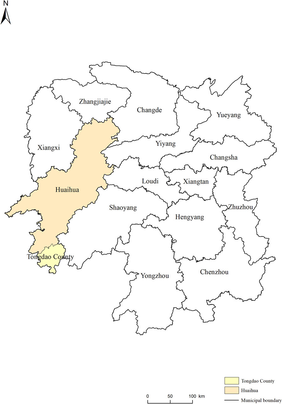
Figure 1. Location of Tongdao County.
Tongdao County is characterized by mountainous terrain with great ups and downs. The general outline of its geomorphology is as follows, north of the watershed, east, south, and west of the higher, the northern part of the rise, the central depression, the terrain to the center, to the west tilt, the mountains and hills, valleys, with a clear belt distribution pattern. South of the watershed, the geothermal from north to south has a sharp decline, the surface is cut deep, and the terrain is undulating, with high mountains and deep valleys. The middle and low mountains are the main landforms of Tongdao County.
The data used in this study mainly include land use data, DEM data, meteorological data, and related statistics. The land use data, DEM data, and meteorological data of Tongdao County for the three periods of 2000, 2010, and 2020 are all from the Resource and Environment Science and Data Center of the Chinese Academy of Sciences (http://www.resdc.cn/), with a spatial resolution of 30 m × 30 m, in which the elevation and average slope are extracted based on the ArcGIS software through the DEM data. The data of transportation road networks and urban settlements are from the land survey data, and the POI data are from amap, which are categorized into public management service, transportation facility space, life service space, etc., according to their own attributes and research needs. The data processing tool is ArcGIS10.8, and the spatial data are unified to the same coordinate system and projection system (WGS_1984_Albers).
Starting from the land use characteristics of Tongdao County, drawing based on existing studies (Jiang and Liu, 2020; Liu et al., 2017), based on the principle of dominant function of land use, combined with the local reality, as a way to construct the PLES classification system of Tongdao County. The system contains two levels of classification; the first level of classification consists of ecological land, production land, and living land; the second level of classification mainly consists of land types subdivided under the first level of classification, with a total of five subclasses (Table 1). Ecological space is comprised of forest land, grassland, and water bodies; production space includes arable land; and living space land is mainly settlements and construction land.
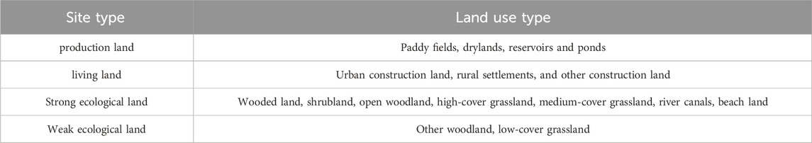
Table 1. Production-living-ecological spaces classification system in Tongdao County.
The land use transition matrix reflects the direction and amount of transfers out and in for each land use type during the study period through a matrix table. Its formula is (Equation 1):
Where: M represents the land use change area matrix; n represents the number of land use types; i and j represent the land use types before and after the change; represents the area of land type i transformed into land type j. The larger the value indicates the more drastic the change, and vice versa, the change is small, and
For discontinuous land pattern changes, the landscape pattern index highly condenses the spatial pattern information, and the landscape pattern index analysis based on land use data is an important tool for the study of landscape spatial patterns (Yu et al., 2020). With the support of Fragstats 4.3 software, the patch density, largest patch index, and aggregation index were selected from the landscape type level index to analyze the characteristics of cropland pattern changes (Table 2).
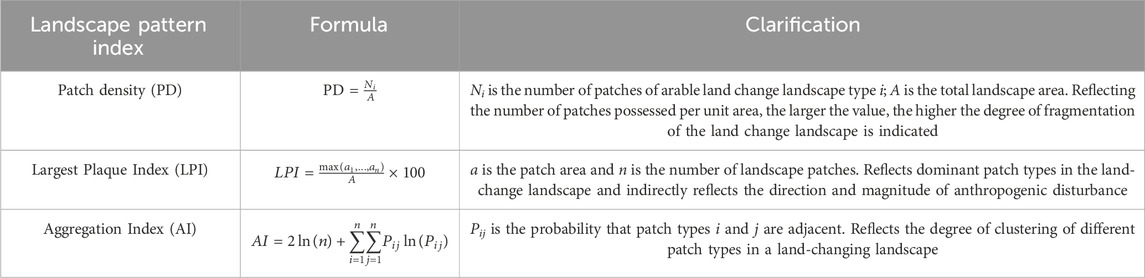
Table 2. Landscape pattern index and calculation formula.
GeoDetector is a set of statistical tool for detecting spatial heterogeneity and revealing the driving forces behind it (Wang and Xu, 2017). In recent years, GeoDetecetor has also been used to study sources of soil contamination (Liu et al., 2025), groundwater potential (Tegegne et al., 2024). It includes a factor, risk, ecological, and interaction detector. The calculation formula is (Equation 2):
Where, q is the explanatory power index of the influence factors of the triton space, with a value range of [0,1], and its larger value indicates that the driver has a greater degree of influence on the triton space, and vice versa, the weaker it is; L is the number of classifications of the influence factors; Nh and N are the number of cells in layer h and the study area, respectively; and σℎ2 and σ2 are the three tritons of the triton space utilized in the layer h and the study area Variance.
The formation and evolution of the spatial pattern of PLES is a spatial presentation of the combined effect of natural geographic factors and socioeconomic factors (Liu et al., 2020)。According to the characteristics of the geographic environment of Tongdao County, combined with relevant research (Shi et al., 2018; Wu and Meng, 2020), In this paper, we select elevation (Elevation), average slope (Slope), average annual temperature (Tem), average annual precipitation (Pre), distance to the rural road (DisRural), distance to highway land (DisRoad), distance to railroad land (DisRail), distance to the river water surface (DisRiver), POI of public management service (PM), POI of transportation facility (TF), POI of living service space category (LS), POI of commercial service space category (CS), POI of entertainment and leisure space category (EL), and POI of green space and ecological space category (GE), a total of 14 indicators, to detect the driving factors of the evolution of PLES.
Influenced by natural and socioeconomic factors, there are obvious differences in the level of PLES patterns in Tongdao County (Figure 2). In 2020, production land, living land, strong ecological land, and weak ecological land in Tongdao County accounted for 7.25%, 0.37%, 90.89%, and 1.49% of the county’s total area respectively, with the strong ecological space occupying an absolute position (Table 3). Among them, the production space is distributed in the county in the form of a band; the living space is dispersed throughout the production and ecological space in the form of a point, and the patches are expanding continuously in any order, and they are urban settlements of varying sizes, while the strong ecological space is the most extensively distributed and has the largest area in Tongdao County, primarily consisting of mountainous forest land. The main reason affecting the horizontal distribution is that the main topography of the county is mountainous with hills and valleys, and there is an obvious belt distribution law, the ecological space is basically distributed in the mountainous areas, and most of the production space and living space is distributed in the hills and valleys where the topography is more moderate, and therefore it is also distributed in the shape of a belt.
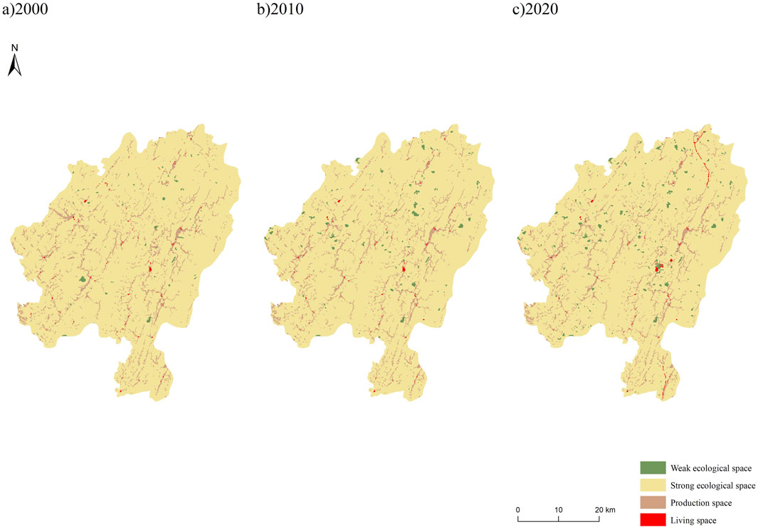
Figure 2. Pattern and evolutionary characteristics of PLES in Tongdao County. (a) 2000. (b) 2010. (c) 2020.
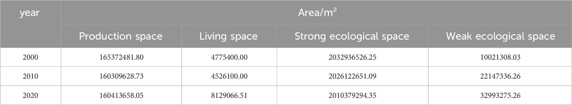
Table 3. Changes in the area of PLES in Tongdao County during 2000–2020.
During the period of 2000–2010, the distribution pattern of ecological space, production space and living space in Tongdao County has changed relatively little, with some adjustments to the range of some weak ecological space or strong ecological space, and some small-scale expansion or changes in living space. During the period of 2010–2020, the changes will be more pronounced, with the range of living space expanding, showing a more obvious growth trend in Shuangjiang Town, Longcheng Town and Xikou Town. The distribution of ecological space has also been adjusted to some extent, with the area of weak ecological space in Xikou Town decreasing more significantly, and the strong ecological space in the whole county being squeezed out by other spaces, especially living space. The production space, on the other hand, has relatively little change and is relatively stable.
There are obvious differences in the vertical gradient of PLES in Tongdao County. Taking 600 m above sea level and 8° slope as the boundary, the living space, production space, and weak ecological space were concentrated in the area below the boundary, and the strong ecological space was mainly distributed in the area below 600 m above sea level. The living space and production space show a trend of rising and then falling with the elevation, and the peaks of the number of spaces appear at 400–600 m. This reflects that the natural environment and soil and water resources in the range of 400–600 m above sea level in the county are the most suitable areas for human life and production. The maximum values of strong ecological space and weak ecological space both appeared at the altitude of 400–600 m (Figure 3).The influence of slope on PLES showed that the living and production space were concentrated in the 0°–8° region and steadily declined as slope increased; the area of strong ecological space and weak ecological space showed a trend of decreasing with the rise of slope and were concentrated in the area of 8–15° (Figure 4). The main reason affecting the vertical distribution is the flat terrain and excellent hydrological conditions of the low-altitude plains and hills, which are suitable for agricultural production and human life, while the high-altitude areas are mostly ecological spaces due to the steep terrain, which is not suitable for human production and life.

Figure 3. Distribution of PLES by elevation in Tongdao County.
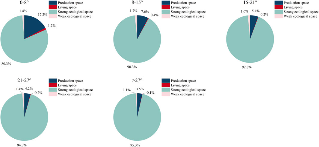
Figure 4. Distribution of PLES by slope in Tongdao County.
The weak ecological space in Tongdao County had an increasing tendency between 2000 and 2020, increasing two times in 20 years, with a total increase of 22971967.23 m2; the living space and production space experienced fluctuating changes of decreasing and then increasing, in which the living space, in general, increased nearly one time, with a total area of 360,3516 m2; the production space in general decreased in area of 4958824 m2; only the strong ecological space shows a continuous decreasing trend, reducing the area by 22557232 m2.
As can be seen from Figure 5, from 2000 to 2010, strong ecological space was mainly transformed into weak ecological space and production space, production space was mainly transformed into strong ecological space, and living space accounted for a relatively small proportion, most of which was transformed from strong ecological space; from 2010 to 2020, the proportion of strong ecological space transformed into living space increased dramatically, and the proportion of production space transformed into living space also increased relatively. Living space nearly doubles in size due to the transfer of other spaces. During the 20 years, living space and weak ecological space are less converted to other space, while the area of strong ecological space to other space is the largest, amounting to 6306623626 m2, and the area of transferring out to other space is larger than the area of its transferring into it, of which 51.75% is converted to weak ecological space, and 42.26% is converted to production space. Weak ecological space is mainly inter-transformed with strong ecological space.
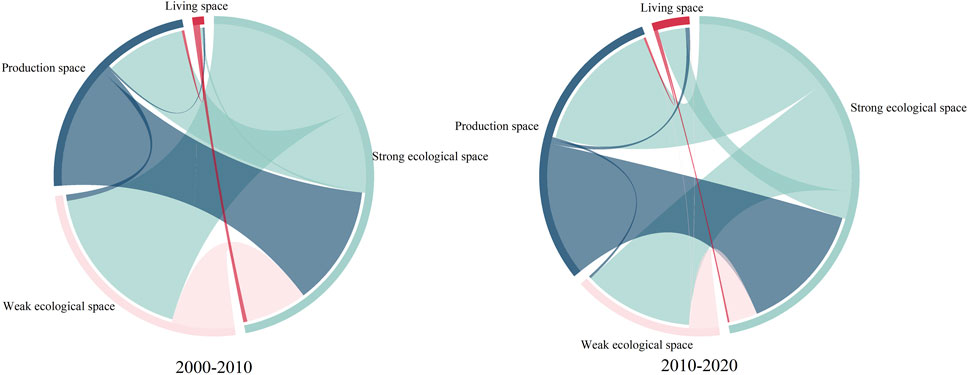
Figure 5. Interconversion of PLES in Tongdao County during 2000–2020.
To sum up, the area of PLES in Tongdao County has changed significantly over time, with the living space encroaching on the production space under the impetus of rapid urbanization, and at the same time, the area of the strong ecological space has decreased as a result of both the county’s ecological environment deteriorating and its living space growing. Production space and strong ecological space are frequently transformed into each other. The lesser transformation of living space into strong ecological space and production space is related to the local urbanization process and infrastructure development. The mutual transformation of weak and strong ecological space reflects the dynamic changes in the regional ecological environment.
As can be seen from Figure 6, the spatial transformation of PLES in the past 20 years has been very decentralized in Tongdao County, and during the period from 2000 to 2010, there was a concentration of strong ecological space transformed into production space in the town of Xianxi, the area of weak ecological space transformed into strong ecological space is the largest, with an area of 18,243,557 m2, which is distributed throughout the entire county; and the area of strong ecological space transformed into production space is 13279442 m2, mostly expanding around on the basis of the original production space. From 2010 to 2020, the transformation of PLES is mainly the mutual transformation of the production space and the strong ecological space in the whole county, and mainly changes on the basis of the original production space, which is related to the land use and ecological protection policies formulated by the government and the demand of the economic development and the advancement of the agricultural technology. In the northern part of the county, there are patches of weak ecological space transformed into strong ecological space, in the central part of the county, weak ecological space transformed into production space and strong ecological space, as well as the transformation of strong ecological space to weak ecological space dispersed throughout the county.
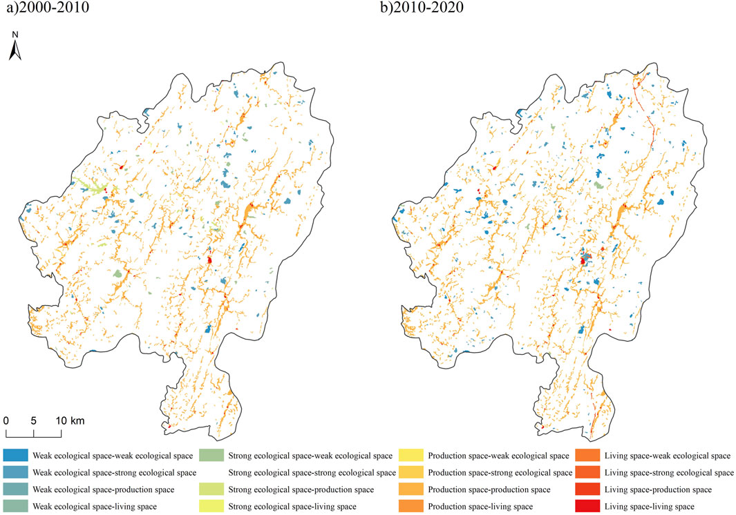
Figure 6. Spatial differences in changes in PLES in Tongdao County during 2000–2020. (a) 2000-2010, (b) 2010-2020.
The landscape pattern index was further applied to analyze the characteristics of the changes in PLES patterns in the two study periods, The results demonstrated that, in comparison to 2000–2010, the patch density of each type of cultivated land modification increased between 2010 and 2020, which indicated that due to the rapid mobility of factors of production and the increase in the intensity of economic activities in this period, land use drastic changes, the heterogeneity of landscape patches increased. The landscape land type of PLES changes showed a trend of fragmentation. The landscape land type of PLES changes showed a trend of fragmentation. The largest patch index of the life space to strong ecological space increased significantly in 2010–2020, from 0.0041% in 2000–2010 to 0.0331% in 2010–2020, which indicates that the patch area increased by living space to strong ecological space is larger compared to that of 2000–2010, and there is a trend of aggregation with the original patches, indicating that the dominant patches in the process of transformation of PLES have been protected to a certain extent. The aggregation index generally shows a decreasing trend, indicating that the transformation of PLES tends to be decentralized (Table 4).
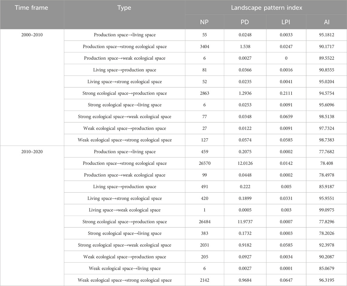
Table 4. Landscape pattern indices for PLES change types during 2000–2020.
As seen from Figure 7, production space increased only in the area of 600–800 m above sea level during the 20 years and decreased in all other altitude segments, with the greatest decrease in the area of 174–400 m above sea level. Living space increased significantly in the lower altitude segments. Strong ecological space decreased significantly in the area above 600 m, while weak ecological space increased in all altitude segments except 1000–1200 m, with the greatest increase in the 400–600 m altitude segment. From the point of view of slope, the production space in the area between 0°–8° of slope decreases significantly, the living space in the area between 8°–15° of slope increases the most, and the strong ecological space in the area above 8° of slope decreases significantly. The increase in the area of weak ecological space was more significant in the 8°–15° and 15°–21° slope intervals. In contrast, areas with larger slopes (e.g., >27°) are more fragile ecological environments due to gravity, soil erosion, and other factors, and natural erosion and other factors make ecosystem stability somewhat disturbed, leading to a decrease in strong ecological space and an increase in weak ecological space. Taken together, production and living space are greatly affected by altitude and slope, and tend to be distributed in areas with relatively low elevation, relatively flat terrain, and water and heat conditions that may be more suitable for the development of human production and living activities; elevation and slope have less of an impact on ecological space, which is typically found in mountainous and hilly areas with large slopes and medium to high elevation.
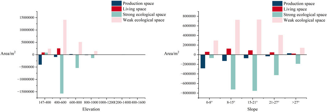
Figure 7. Vertical change in PLES in Tongdao County during 2000–2020.
Selecting the administrative centers of eleven townships in Tongdao County to make 0–9000 m buffer zones for the townships at 3000 m intervals, the area of PLES between the buffer zones was counted in 2000, 2010, and 2020 (Figure 8). The living space tends to be distributed in the area close to the town center, mainly in the range of 0–3000 m, and in recent years there has been a tendency to spread outward, and the area within the range of 0–3000 m has been reduced, which may be related to the development of urbanization, urban planning, and ecological protection, and other human activities and policy orientation. In the area of 3000–6000 m, the area of living space in 2020 is twice as much as that in 2000. The distribution of production space is centralized in 6000–9000 m, with a tendency to spread inward in recent two decades and a certain degree of increase in the area within the buffer zone of 0–3000 m. Strong ecological space and weak ecological space are mostly distributed farther away from towns, with more strong ecological space within the 6000–9000 m buffer zone and relatively weaker ecological space within the 3000–6000 m buffer zone. The spatial relationship between PLES and the towns reflects that both the strong and weak ecological spaces near the town settlements are transformed by the influence of town expansion.
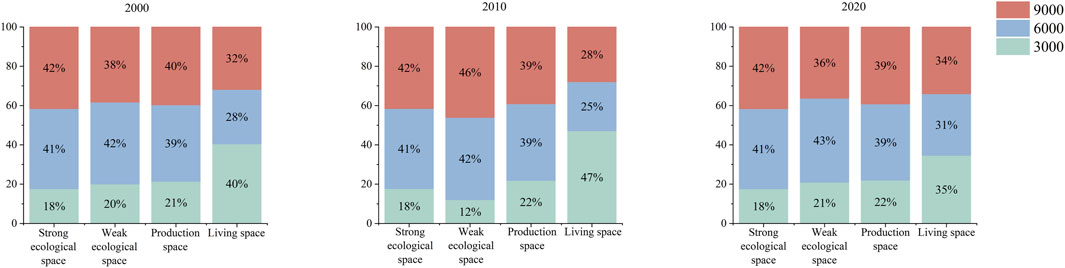
Figure 8. Distribution of PLES in different buffer zones of typical townships in Tongdao County.
Natural geographic factors are the fundamental conditions affecting the formation and evolution of the pattern of PLES in Tongdao County. Natural geographic factors can redistribute light, water, heat, and other conditions of regional land use, which limits human development and utilization of land and constrains the spatial configuration of land. The probability of changes in cropland pattern is greater in areas with smaller elevation and slope, and the degree of interference with the land by human activities decreases with the increase of elevation and slope. From the results of factor detection (Table 5), the average annual temperature had the most significant effect on PLES. This was followed by mean annual precipitation, elevation, and slope. The average annual temperature can determine the types of local crops and affect the crop ripening system, as well as affecting the distribution of population and regional development, people tend to gather in areas where the average annual temperature is more suitable, while areas where the temperature is too high or too low are relatively sparsely populated and unsuitable for crop production, so they are more of an ecological space; the areas with moderate precipitation are able to meet the demand for water for municipal residents’ domestic use and for industrial use, so they are mostly a space for living and production; the middle and low altitude areas have good thermal conditions and convenient transportation, which are suitable for agricultural activities and human habitation, while the high altitude areas have thin air and complex topography, so most of them are ecological spaces; the areas with smaller slopes are suitable for agricultural reclamation and urban construction, so most of them are production and living spaces, and the agricultural and industrial development in the areas with higher slopes is prone to soil and water erosion, so most of them are ecological spaces. The terrain of Tongdao County varies greatly, with significant differences in elevation and slope within the region, which makes it a county with a more significant driving force for land use type changes.
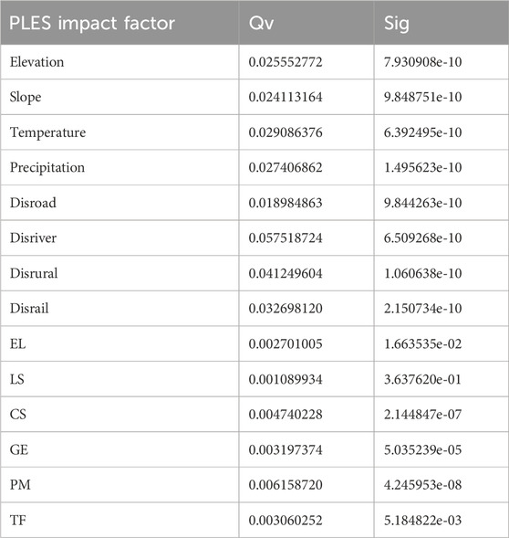
Table 5. Detection results of the drivers of spatial evolution of PLES in Channel County.
Spatial distance plays a dominant controlling role in shaping the pattern of land use, and its driving effect on the changes of land use pattern is very significant; areas closer to the river water surface and rural roads have relatively frequent agricultural production activities, and areas at a moderate distance from the water surface of the river are the main areas for urbanization. Areas closer to railroads and highways have frequent industrial and commercial activities, and the increase of human activities around these areas directly leads to the increased probability of changes in the type of land use. While areas farther away from railroads and highways are less accessible and are more ecological and production spaces.
Socioeconomic conditions are the primary driving force influencing the pattern of PLES in Tongdao County. The detection results show that except for the entertainment and leisure type elements that have no discernible impact on the changes in the pattern of PLES, the rest of the POI elements have a certain degree of influence on the changes in the pattern of PLES in Tongdao County. The distribution of POI has a certain degree of agglomeration and will attract related land-use types to cluster towards them. For example, large commercial centers will attract the surrounding commercial stores and catering establishments to cluster and form commercial clusters; while some ecological protection POI, such as nature reserves and forest parks, will guide the surrounding land to maintain the nature of ecological land use, forming a relatively decentralized land use pattern and a clear separation from the urban construction area. Geospatial elements are the indirect manifestation of socioeconomic development, and as the ability of agglomeration development is strengthened in Tongdao County during the study period, the development and utilization of land and the changes of utilization type have occurred frequently, which exactly explains the stronger driving role of POI geospatial elements.
Figure 9 shows that the two-by-two interaction of each driving factor in PLES is stronger than the interaction within a single factor, all nonlinearly enhanced and two-factor enhanced, suggesting that the drivers are not independent individuals from each other, but rather that there are complex interactions. Specifically, the interaction between distance from river water surface and mean annual precipitation had the greatest explanatory power for the spatial pattern of PLES, indicating that distance from river water surface affects mean annual precipitation, which in turn affects the spatial pattern of PLES. Meanwhile, the distance to river water surface showed a more significant synergistic enhancement effect with the remaining 12 factors. This reflects that the distance to the river water surface affects the location of roads and points of interest, which in turn affects the spatial pattern of PLES. The interaction between elevation and the other factors was also strong because elevation affects temperature, precipitation, and people’s choice of roads and sites of interest, which in turn affects the spatial pattern of PLES. In addition, the interaction between human and natural factors is generally stronger than the interaction between natural factors, which has an important impact on the evolution of the PLES pattern in Tongdao County.
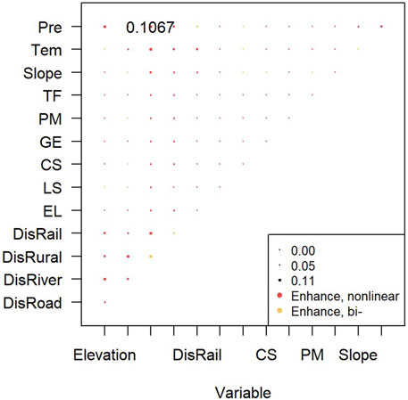
Figure 9. Interaction detection results of the drivers of the evolution of PLES in Tongdao County during 2000–2020.
Based on the process of the evolution of PLES and the driving factors revealed in Tongdao County, this paper analyzes the distribution and evolution of PLES and their driving forces in Tongdao County and discusses the long-term plan for environmentally conscious preservation and development.
Strong ecological space is concentrated in the remnants of the Miao Ling and the remnants of the Xuefeng Mountains. In recent years, with the social and economic development of Tongdao County, the living space has been expanding, which has caused certain pressure on the strong ecological space. Meanwhile, due to the early rough mode of national land development and the insufficient understanding of the ecological function of the land, which led to the blind occupation of the ecological space, the quality of the ecological environment has been damaged, and the strong ecological space is decreasing continuously. Based on improving the construction of Hunan Yudaihe National Wetland Park, Mount Wanfo and Dongzhai Scenic and Historic area, and Hunan Qilin Mountain Provincial Nature Reserve, maintain and improve the protection for wetlands, grasslands, and natural forests, and rigorously implement the projects of soil and water conservation and treatment, mine restoration, and converting farmland back into forests and grasslands. To focus on ecological conservation of ecological, characteristic, and cultural development path. Combined with industry cultivation, water conservation, ethnic culture protection and inheritance, and targeted poverty reduction, the function of strong ecological space will be continuously improved.
Weak ecological space is dominated by other woodlands and low-cover grasslands, mostly distributed around strong ecological space. Although the ecological function is weak, the area is widely spread and has been increasing in recent years. Weak ecological space is fragile and sensitive, and reducing human interference is the key to ecological restoration and preventing the degradation of strong ecological space into weak ecological space, with measures such as strictly prohibiting pastoralism, rotating pastoralism, and resting pastoralism; in addition, Ecological restoration projects such as water and sand management and key forestry should be implemented to restore and expand the size of natural oases (Yang et al., 2021).
Production space is concentrated in areas with low elevations and gentle slopes, with production functions as the mainstay and ecological functions considered. In recent years, the production space has been gradually reduced, and the “three lines and three zones” have been delineated and defined in the context of land space planning, with controlling land use as a crucial instrument for preventing significant alterations to ecological space and enhancing its overall suitability. Based on the different geographic conditions of each township, the layout of production space and ecological space has been scientifically guided to prevent the replanting of fallow forests and the degradation of newly afforested land, and the strict implementation of the relevant engineering standards should also take into account the topography of specific areas, sunshine, precipitation, and other natural factors, to make the layout of production space more rational.
Living space is dominated by towns and rural settlements at all levels, mostly scattered around production space, with strong production and living functions. In recent years, there has been a significant trend in the expansion of the area, mainly crowding out ecological space. With the rapid development of China’s economy and the acceleration of urbanization, various economic and social activities that were previously concentrated in the central urban areas are gradually spreading to the suburbs (Gao and Cheng, 2020). Excessive human activities have polluted and damaged the ecological space, affecting the fulfilment of its ecological functions. It is necessary to plan and build an appropriately sized urban system, advocate conservation and intensive utilization, and promote land improvement projects in rural settlements; to increase the renovation and upgrading of old urban areas and rural settlements, and to expand rest and green space, to improve the sense of wellbeing of residents.
The formation and evolution of PLES in Tongdao County embodies the integrated interactive coupling of natural background and socioeconomic factors. The natural geographic factors are the fundamental conditions for the evolution of PLES, and the socioeconomic factors have an obvious driving role. The introduction of POI point data enriches the identification system of the driving factors for changes of PLES, effectively identifies the importance of each spatial driving factor for changes of PLES in combination with GeoDetector, and enriches the research methodology of the influencing factors for changes of PLES. However, due to the complexity of the changes in the land system, the relevant research still needs to be refined and deepened, and the systematic and comprehensive exploration of the driving factors of the PLES changes should be further carried out in the future.
Combined with the resource and environmental carrying capacity, ecological vulnerability, and socioeconomic development level of the county, scientifically delineate the living and production space boundary, strengthen the boundary control and supervision mechanism, construct a new pattern of ecological civilization construction with sustainable development and coordination of “production-living-ecological,” and improve the key technical links of rational allocation and governance and the response of the regional land space resources, to guarantee the high-quality development of urbanization and ecological space security in the county. Efforts should be made to improve the land use efficiency of production and living space and to ensure that the socio-economic development of Tongdao County will not be at the expense of the rough use of land space.
In conclusion, this study provides a scientific basis for revealing the characteristics of the evolution of the spatial pattern of PLES and its driving forces in Tongdao County and mountainous counties of the same type. The introduction of POI point data enriched the identification system of the drivers of the changes in the spatial pattern of PLES, combined with the GeoDetector effectively identified the importance of each spatial driver on the changes in the pattern of PLES, and enriched the research method of the influencing factors of the changes in the spatial pattern of PLES. The GeoDetector is very effective in detecting the spatial heterogeneity, as well as revealing the driving force behind it, but it is difficult to reveal the specific mechanism and process of the interaction between the independent variable and the dependent variable in-depth. Therefore, we incorporate buffer analysis to visualize the mode of action between variables and assist in understanding the spatial mechanism of action. However, although POI data can effectively express geographic information and is representative of various functions and socio-economic activities of the city, there are still some shortcomings: firstly, due to the fact that its data are expressed as point-like entities, it is difficult to completely express the specific location of the information points of a large area, which results in the irrational expression of the spatial characteristics of the region, and it is prone to analytical errors. Secondly, the large number of POI data and the lack of labeling. The categorization, comparison, de-duplication of its data and mining of deeper information on urban development are still lacking. Therefore, structural equation modeling as well as regression analysis can be introduced in the future to further carry out a systematic and comprehensive exploration of the driving factors of the changes in the spatial pattern of PLES.
In this study, based on GIS technology and R language programming, the land transfer matrix and landscape pattern index were used to reveal the characteristics of the changes in the pattern of PLES from 2000 to 2020 in Tongdao County as the study area, and GeoDetector were utilized to explore the spatial driving factors for the changes in the pattern of PLES from the perspective of spatial elements, and the following conclusions were mainly drawn:
There are distinct variations in the level of the distribution pattern of PLES in Tongdao County. The ecological space occupies the main position (about 92.38%). While the weak ecological space is widely dispersed, the strong ecological space is primarily ditributed in the Xuefeng and Miaoling Mountains; the production space accounts for about 7.25%, concentrated in the central part of the county, and the living space accounts for only 0.37%, sporadically dispersed in the center of towns and cities. In the past 20 years, the living space fluctuated and increased, the production space fluctuated and decreased, the strong ecological space continued to decrease, and the weak ecological space continued to increase.
Vertical differentiation in the distribution of PLES in Tongdao County is remarkable. Taking 600 m above sea level and 8° slope as the boundary, production space, living space, and weak ecological space are concentrated in the area below the boundary, and the strong ecological space is mainly distributed below 600 m above sea level. During the 20 years, the living and production space tends to be distributed in areas with relatively low altitudes and gentle slopes, while the areas with high altitudes are mainly strong ecological space and weak ecological space.
The distance to the river surface and the distance to rural roads have a substantial impact on the spatial distribution of PLES in Tongdao County. The spatial pattern of living and production space is distributed around the town center and along the traffic roads, while the ecological space is distributed in the area far away from the town center and the traffic roads, and the functional transformation of land use in the past 20 years is mainly manifested in the erosion of production and ecological space by the living space, and the encroachment of production space into the ecological space at the same time. The trend of ecological space being encroached upon by living space and production space has increased, reflecting that the development of urbanization and industrialization is the main reason for the encroachment of ecological space.
The driving factors of PLES have both individual direct effects and interactive effects, and pa, especially the distance to the river surface and the distance to the road have the strongest influence on the interaction with natural factors.
Publicly available datasets were analyzed in this study. This data can be found here: (http://www.resdc.cn/DOI), 2018. DOI: 10.12078/2018070201.
HC: Conceptualization, Data curation, Formal Analysis, Investigation, Methodology, Software, Validation, Visualization, Writing–original draft. WL: Funding acquisition, Resources, Supervision, Writing–review and editing. ML: Formal Analysis, Project administration, Software, Writing–review and editing.
The author(s) declare that no financial support was received for the research, authorship, and/or publication of this article.
The authors declare that the research was conducted in the absence of any commercial or financial relationships that could be construed as a potential conflict of interest.
The author(s) declare that no Generative AI was used in the creation of this manuscript.
All claims expressed in this article are solely those of the authors and do not necessarily represent those of their affiliated organizations, or those of the publisher, the editors and the reviewers. Any product that may be evaluated in this article, or claim that may be made by its manufacturer, is not guaranteed or endorsed by the publisher.
Bao, W., Yang, Y., and Zou, L. (2021). How to reconcile land use conflicts in mega urban agglomeration? A scenario-based study in the Beijing-Tianjin-Hebei region, China. J. Environ. Manag. 296, 113168. doi:10.1016/j.jenvman.2021.113168
Dang, L., Xu, Y., and Gao, Y. (2014). Assessment method of functional land use classification and spacial system. Res. Soil Water Conservation 21, 193–197+203. doi:10.13869/j.cnki.rswc.2014.05.034
Duan, Y., Wang, H., An, H., Yueqing, X., Lu, L., and Ji, Z. (2021). Identification and spatial-temporal evolution of rural “production-living-ecological” space from the perspective of villagers’ behavior – a case study of Ertai Town, Zhangjiakou City. Land Use Policy 106, 105457. doi:10.1016/j.landusepol.2021.105457
Fan, J., Zhang, Z., and Li, L. (2015). Mountain demarcation and mountainous area divisions of Sichuan Province. Geogr. Res. 34, 65–73. doi:10.11821/dlyj201501006
Gao, C., and Cheng, L. (2020). Tourism-driven rural spatial restructuring in the metropolitan fringe: an empirical observation. Land Use Policy 95, 104609. doi:10.1016/j.landusepol.2020.104609
Jiang, M., and Liu, Y. (2020). Discussion on the concept definition and spatial boundary classification of “production-living-ecological” space. Urban Dev. Stud. 27, 43–48. doi:10.3969/j.issn.1006-3862.2020.04.007
Jiang, X., Zhai, S., Liu, H., Chen, J., Zhu, Y., and Wang, Z. (2022). Multi-scenario simulation of production-living-ecological space and ecological effects based on shared socioeconomic pathways in Zhengzhou, China. Ecol. Indic. 137, 108750. doi:10.1016/j.ecolind.2022.108750
Jiao, G., Yang, X., Huang, Z., Zhang, X., and Lu, L. (2021). Evolution characteristics and possible impact factors for the changing pattern and function of “Production-Living-Ecological” space in Wuyuan county. J. Nat. Resour. 36, 1252–1267. doi:10.31497/zrzyxb.20210513
Kheyruri, Y., Sharafati, A., Neshat, A., Hameed, A. S., and Rahman, A. (2024). Analyzing the impact of socio-environmental parameters on wheat and barley cultivation areas using the geographical detector model. Phys. Chem. Earth, Parts A/B/C 135, 103630. doi:10.1016/j.pce.2024.103630
Li, B., Zeng, C., Dou, Y., Liu, P., and Chen, C. (2018). Change of human settlement environment and driving mechanism in traditional villages based on living-production-ecological space: a case study of Lanxi Village, Jiangyong County, Hunan Province. Prog. Geogr. 37, 677–687. doi:10.18306/dlkxjz.2018.05.011
Li, G., and Fang, C. (2016). Quantitative function identification and analysis of urban ecological-production-living spaces. Acta Geogr. Sin. 71, 49–65. doi:10.11821/dlxb201601004
Li, J., and Shen, W. (2019). A study on the inheritance path of cultural capitalization of Dong ethnic areas in the three provinces of Hunan,Guizhou and Guangxi. Guizhou Ethn. Stud. 40, 111–118. doi:10.13965/j.cnki.gzmzyj10026959.2019.09.019
Li, X., Li, D., and Liu, X. (2017). Geographical simulation and optimization system(GeoSOS) and its application in the analysis of geographic national conditions. Acta Geod. Cartogr. Sinica 46, 1598–1608. doi:10.11947/j.AGCS.2017.20170355
Liao, G., He, P., Gao, X., Deng, L., Zhang, H., Feng, N., et al. (2019). The production–living–ecological land classification system and its characteristics in the hilly area of sichuan province, southwest China based on identification of the main functions. Sustainability 11, 1600. doi:10.3390/su11061600
Liao, L., Dai, W., Chen, J., Huang, W., Jiang, F., and Hu, Q. (2017). Spatial conflict between ecological-production-living spaces on Pingtan Island during rapid urbanization. Resour. Sci. 39, 1823–1833. doi:10.18402/resci.2017.10.03
Lin, G., Jiang, D., Fu, J., and Zhao, Y. (2022). A review on the overall optimization of production–living–ecological space: theoretical basis and conceptual framework. Land 11, 345. doi:10.3390/land11030345
Liu, J., Liu, Y., and Li, Y. (2017). Classification evaluation and spatial-temporal analysis of “production-living-ecological” spaces in China. Acta Geogr. Sin. 72, 1290–1304. doi:10.11821/dlxb201707013
Liu, T., Wang, M., Wang, M., Xiong, Q., Jia, L., Ma, W., et al. (2025). Identification of the primary pollution sources and dominant influencing factors of soil heavy metals using a random forest model optimized by genetic algorithm coupled with geodetector. Ecotoxicol. Environ. Saf. 290, 117731. doi:10.1016/j.ecoenv.2025.117731
Liu, Y., Li, J., and Yang, Y. (2018). Strategic adjustment of land use policy under the economic transformation. Land Use Policy 74, 5–14. doi:10.1016/j.landusepol.2017.07.005
Liu, Y., Lin, Y., Wang, F., Xu, N., and Zhou, J. (2023). Post-earthquake recovery and its driving forces of ecological environment quality using remote sensing and GIScience, a case study of 2015 Ms8.1 Nepal earthquake. Geomatics, Nat. Hazards Risk 14, 2279496. doi:10.1080/19475705.2023.2279496
Liu, Y., Zhou, X., He, Z., Hao, H., and He, G. (2020). Quantitative evolution and marginal effect analysis of spatial factors of cultivated land based on Logistic regression. Trans. Chin. Soc. Agric. Eng. 36, 267–276. doi:10.11975/j.issn.1002-6819.2020.11.032
Qin, Y., Wang, L., Yu, M., Meng, X., Fan, Y., Huang, Z., et al. (2024). The spatio-temporal evolution and transformation mode of human settlement quality from the perspective of production-living-ecological spaces--a case study of Jilin Province. Habitat Int. 145, 103021. doi:10.1016/j.habitatint.2024.103021
Shi, Z., Deng, W., and Zhang, S. (2018). Spatial pattern and spatio-temporal change of territory space in Hengduan Mountains region in recent 25 years. Geogr. Res. 37, 607–621. doi:10.11821/dlyj201803012
Song, Y., Xue, D., Xia, S., and Mi, W. (2021). Change characteristics and formation mechanism of the territorial spatial pattern in the Yellow River Basin from 1980 to 2018, China. Geogr. Res. 40, 1445–1463. doi:10.11821/dlyj020191065
Tegegne, A. M., Lohani, T. K., and Eshete, A. A. (2024). Groundwater potential delineation using geodetector based convolutional neural network in the Gunabay watershed of Ethiopia. Environ. Res. 242, 117790. doi:10.1016/j.envres.2023.117790
Wang, J., and Xu, C. (2017). Geodetector: principle and prospective. Acta Geogr. Sin. 72, 116–134. doi:10.11821/dlxb201701010
Wang, Q., Liu, X., and Sun, F. (2023). Changes in spatial-temporal pattern of production-living-ecological spaces in poverty-shaken off counties, China. J. Arid Land Resour. Environ. 37, 17–25. doi:10.13448/j.cnki.jalre.2023.205
Wang, Q., and Song, G. (2021). Changes of cultivated land pattern and its spatial driving factors in the typical regions of Lower Liaohe Plain. Trans. Chin. Soc. Agric. Eng. 37, 275–283. doi:10.11975/j.issn.1002-6819.2021.24.031
Wang, W., Hu, Y., and Zhang, Y. (2020). “Ecological-living-industrial” space structure cognition and transformation control framework. China Land Sci. 34, 25–33. doi:10.11994/zgtdkx.20201209.102641
Wu, Q., and Meng, J. (2020). Analysis of the evolution and driving factors of production-living-ecological space pattern in the Heihe River Basin from 1980 to 2020, China. Acta Sci. Nat. Univ. Pekin., 1–12. doi:10.13209/j.0479-8023.2023.056
Yang, Q., Duan, X., Wang, L., and Jin, Z. (2018). Land use transformation based on ecological-production-living spaces and associated eco-environment effects: a case study in the Yangtze River delta. Sci. Geogr. Sin. 38, 97–106. doi:10.13249/j.cnki.sgs.2018.01.011
Yang, X., Meng, F., Fu, P., Zhang, Y., and Liu, Y. (2021). Spatiotemporal change and driving factors of the eco-environment quality in the yangtze river basin from 2001 to 2019. Ecol. Indic. 131, 108214. doi:10.1016/j.ecolind.2021.108214
Yang, Y., Bao, W., and Liu, Y. (2020). Coupling coordination analysis of rural production-living-ecological space in the Beijing-Tianjin-Hebei region. Ecol. Indic. 117, 106512. doi:10.1016/j.ecolind.2020.106512
Yin, L., Wei, W., Bo, L., Zhang, K., and Xia, J. (2024). Analysis on the evolution characteristics and driving forces of territorial space pattern in the Qinling-Daba mountain area. J. Soil Water Conservation 38, 278–293. doi:10.13870/j.cnki.stbcxb.2024.02.025
Yu, J., Chen, Y., Peng, J., Li, J., and Nie, Y. (2020). Comprehensive evaluation on land ecological quality based on GIS and Fragstats: a case study in Xiantao City, Hubei Province. Acta Ecol. Sin. 40, 2932–2943. doi:10.5846/stxb201904100710
Zhang, H., Xu, E., and Zhu, H. (2015). An ecological-living-industrial land classification system and its spatial distribution in China. Resour. Sci. 37, 1332–1338. doi:10.5814/j.issn.1674-764x.2017.02.002
Zhang, J., and Chen, X. C. (2019). Study on the measurement of urban sprawl based on the POI data: a case of Shenyang City, China. China Land Sci. 33, 93–102. doi:10.11994/zgtdkx.20190408.083853
Zhang, J., Shi, W., and Xiu, C. (2021). Urban research using points of interest data in China. Sci. Geogr. Sin. 41, 140–148. doi:10.13249/j.cnki.sgs.2021.01.015
Zhou, Y., Guo, L., and Liu, Y. (2019). Land consolidation boosting poverty alleviation in China: theory and practice. Land Use Policy 82, 339–348. doi:10.1016/j.landusepol.2018.12.024
Zhu, W., Zhang, J., Cui, Y., Zheng, H., and Zhu, L. (2019). Assessment of territorial ecosystem carbon storage based on land use change scenario: a case study in Qihe River Basin. Acta Geogr. Sin. 74, 446–459. doi:10.11821/dlxb201903004
Keywords: mountainous counties, Production-living-ecological spaces, driving factors, spatial evolution, land use
Citation: Cao H, Liu W and Liu M (2025) Evolution and driving factors of “Production-living-ecological spaces” in mountainous counties: a case study of Tongdao County, Hunan Province. Front. Environ. Sci. 13:1503023. doi: 10.3389/fenvs.2025.1503023
Received: 10 October 2024; Accepted: 25 February 2025;
Published: 13 March 2025.
Edited by:
Riccardo Buccolieri, University of Salento, ItalyReviewed by:
Yaohui Liu, Shandong Jianzhu University, ChinaCopyright © 2025 Cao, Liu and Liu. This is an open-access article distributed under the terms of the Creative Commons Attribution License (CC BY). The use, distribution or reproduction in other forums is permitted, provided the original author(s) and the copyright owner(s) are credited and that the original publication in this journal is cited, in accordance with accepted academic practice. No use, distribution or reproduction is permitted which does not comply with these terms.
*Correspondence: Weidong Liu, dDE5ODYxMDk0QGNzdWZ0LmVkdS5jbg==
Disclaimer: All claims expressed in this article are solely those of the authors and do not necessarily represent those of their affiliated organizations, or those of the publisher, the editors and the reviewers. Any product that may be evaluated in this article or claim that may be made by its manufacturer is not guaranteed or endorsed by the publisher.
Research integrity at Frontiers
Learn more about the work of our research integrity team to safeguard the quality of each article we publish.