- 1School of Emergency Management, Institute of Disaster Prevention, Langfang, China
- 2National Institute of Emergency Management, Party School of the Central Committee of C.P.C (National Academy of Governance), Beijing, China
- 3Institute of Mining Green Development, Chinese Academy of Natural Resources Economics, Beijing, China
- 4Editorial Office of Natural Resource Economics of China, Chinese Academy of Natural Resources Economics, Beijing, China
The interplay between land ecological security (LES) and high-quality economic development (HED) is intricately linked to the sustainable development of regions, with their combined influence at the county level being pivotal for the harmonious growth of urban agglomerations. In this study, we employ the entropy-weighted technique for order preference by similarity to ideal solution (EW-TOPSIS), coupling coordination degree (CCD), deviation coordination degree, and relative development degree methodologies to assess the developmental status of LES and HED, as well as the coupling coordination between these two systems, and introduce a novel approach for delineating functional regions. Our findings reveal a pronounced polarization of LES and HED within the Beijing-Tianjin-Hebei (BTH) region, with the majority of areas exhibiting a high degree of coupling but moderate imbalance. Spatial analysis highlights distinct characteristics, allowing for the segmentation of the region into seven distinct development functional zones. Recommendations include the establishment of a collaborative framework for the BTH region, enhancing the innovation, openness, and coordination within HED, and focusing on the advancement of HED in leading, key, and stable development areas. Furthermore, it is essential to elevate the visibility and responsiveness of LES, and strategically implement land ecological engineering in key and stable development areas. These strategic initiatives aim to improve the developmental standards of LES and HED, thereby enhancing the coordination and synergy between these two key systems.
1 Introduction
Recently, the impacts of worldwide climate change have been felt in every inhabited region across the globe. Severe weather phenomena, such as scorching heatwaves, prolonged droughts, devastating floods, powerful cyclones, and rampant wildfires, occur frequently and seriously threaten ecosystem stability, leading to ecosystem degradation and affecting human health and wellbeing (Pörtner et al., 2022). With the increase of extreme weather, the predominant interaction between climate change, ecosystems, and human societies is adverse. Achieving an equilibrium between environmental sustainability and economic prosperity is crucial for enhancing the wellbeing of the global community (Bilgen and Sarikaya, 2015; Sui et al., 2024). Land Ecological Security (LES) is the fundamental pillar of regional ecological security, embodying the sustainability and environmental health of land resources and ecosystems. It plays a vital role in consistently delivering robust ecological services, ensuring the fulfillment of the ecological requirements for future generations (Guo et al., 2021). Hence, the connection between LES and Economic Development (ED) is attracting heightened interest.
The sustainable development of LES and ED and their interactions is an important research topic worldwide. Government and academia have paid close attention to the state of LES in national and local development, encouraging research on the concept of LES and the evaluation of LES. Researchers mainly researched the spatiotemporal changes, influencing factors, and driving mechanisms of land ecological security. Most previous studies have evaluated LES by combining socio-economic indicators (Wang et al., 2018; Wu and Xie, 2019; Zhang et al., 2022; Wang et al., 2023). In addition, some researchers have studied driving factors to explore the relationship between ecological security and socio-economic growth (Feng et al., 2018; He et al., 2021; Wen et al., 2021; Yang et al., 2021). These studies focus on the unidirectional impact of socio-economic factors on land ecological security. However, the relationship between land ecological security and socio-economic factors is bidirectional, and some scholars have analyzed the relationship between the two systems by EKC hypothesis and CCD model. Researching the coordination relationship between LES and ED, and finding a regionally-specific balance is crucial for implementing sustainable development. The EKC hypothesis is frequently employed to examine the interrelationship between LES and ED. By adopting the EKC model, some scholars found that the relationship between LES and ED did not adhere to the typical inverted U-shape pattern (Wang and Zeng, 2013; Yang et al., 2016; Li et al., 2017). The EKC framework overlooks the dynamic interplay among systems (Müller-Fürstenberger and Wagner, 2007), while the coupling coordination degree (CCD) model fills the gap (Wang et al., 2018; Shi et al., 2020). The CCD model has recently been employed in investigating the correlation between LES and ED (Dai, 2019; He et al., 2020; Hou and Jiang, 2020; Zhang et al., 2021). Based on the study of the relationship between ecological security and economic security, Sun et al. (2020) divided the research area into different development zones.
The Chinese economy has shifted its trajectory from rapid expansion to a phase of HED. Adopting HED is crucial for adjusting to the shifting dynamics of the principal societal challenges of China and preserving the sustainability and wellness of its economic growth. Therefore, exploring a path that couples LES and HED in the Beijing-Tianjin-Hebei (BTH) region is necessary. Guo et al. investigated the coupling coordination relationship between LES and HED at the city level in the BTH region (Guo, 2022; Guo et al., 2023). Research on the synchronized advancement of LES-HED subsystems currently faces several notable gaps. First, the deviation coordination model is based on the principle of minimizing the deviation coefficient, with a more rigorous theoretical foundation and more rigorous formula derivation. From the perspective of the number of systems and data characteristics, it is more suitable for the coordinated development relationship between two systems (Wang, 2022). Therefore, using only the CCD model to measure the coordination relationship between the two systems is not systematic and comprehensive enough, restricting regional sustainable development. Second, the key for the government to implement sustainable integration is to know how to comprehensively consider the two elements of LES and HED, and adopt reliable and effective methods to divide different development functional zones, which requires us to evaluate the development level of LES and HED at a smaller scale, such as at the county level, and study the development relationship between them.
The interplay between LES and HED is intricately linked to the sustainable development of regions, and their comprehensive influence at the county level is pivotal for the harmonious growth of urban agglomerations. World-class urban agglomerations constitute crucial growth centers for China’s dynamic economy. Exploring the intrinsic linkage of LES and HED in these regions aligns perfectly with the human socio-economic activities that ecological economics underscores (Costanza, 1978). Therefore, conducting an assessment of LES and HED and exploring their coordination relationship holds immense theoretical and practical value for fostering eco-friendly growth in the Beijing-Tianjin-Hebei (BTH) region. Therefore, the paper established a research framework of “system level evaluation–coordination relationship measurement–development types identification–functional areas division”. First, this study conducts an evaluation index system for LES and HED. It applies the EW-TOPSIS method to assess the development level of LES and HED in 2018 by using counties as evaluation units. Second, analyzing the spatial correlation effect between LES and HED by using the bivariate spatial autocorrelation model. Third, this study calculates the coupling degree and coordination degree by employing the CCD models and the dispersion coordination degree, and analyzes the temporal and spatial trends of the coupling stage and coordination relationship. Fourth, by adopting the relative development model, this study identifies the regional coordinated development types. It comprehensively considers the regional coupling stage, coordination relationship, and development type, and defines the regional composite types. On this basis, the functional areas of the BTH region are analyzed and divided, and specific policy recommendations are put forward. This study aims to provide theoretical support for sustainable development in China and abroad.
2 Materials and methods
2.1 Study area
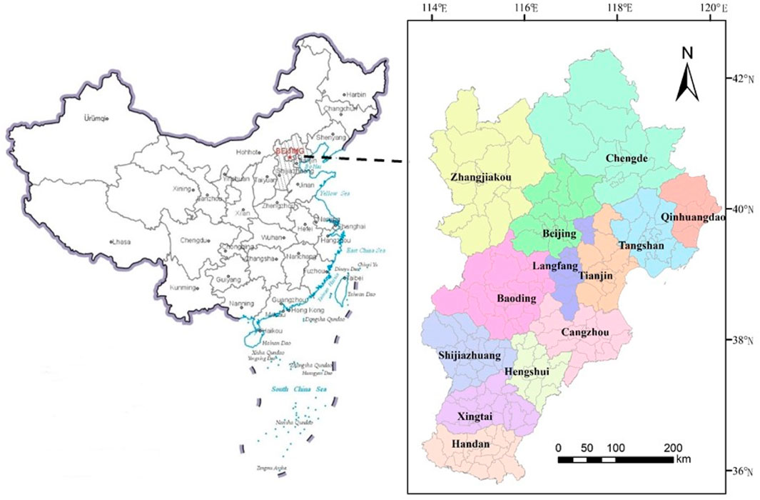
The BTH region is located in the hinterland of central North China, covering an area of approximately 218,000 km2, including 13 cities (i.e., Beijing, Tianjin, Shijiazhuang, Baoding, Cangzhou, Chengde, Handan, Hengshui, Langfang, Qinhuangdao, Tangshan, Xingtai, and Zhangjiakou). By the end of 2022, the resident population (year-end) in this region amounted 109.67 million, the urbanization level attained a substantial proportion of 69.7%, and the gross domestic product scaled the lofty height of 10.03 trillion yuan. The region stands as one of the three world-class urban conglomerations, serving as a pivotal platform for engaging in global competitive collaboration and facilitating international cooperation. HED constitutes the cornerstone for enhancing the coordinated development level and building a world-class urban agglomeration. Nonetheless, the region grapples with an uneven economic structure, pronounced disparities in social welfare provisions, acute water scarcity, and rampant land degradation, all imposing stringent constraints on its pursuit of HED and posing significant threats to LES. Therefore, conducting an assessment of LES and HED, alongside exploring their coordinated relationship, holds immense theoretical and practical value for fostering eco-friendly growth in the BTH area. The study area includes 200 counties (districts) in the BTH region, except the municipal districts (Figure 1).
2.2 Data sources
The data is gathered from the statistical yearbooks of the BTH region, including the China Statistical Yearbook 2019, the China Urban Statistical Yearbook 2019, and additional statistical yearbooks of the BTH region, encompassing the Hebei Economic Yearbook 2019, the Hebei Rural Statistical Yearbook 2019, Beijing Regional Statistical Yearbook 2019, Tianjin Statistical Yearbook 2019, Shijiazhuang Statistical Yearbook 2019, Hengshui Statistical Yearbook 2019, Baoding Economic Statistical Yearbook 2019, Handan Statistical Yearbook 2019, Cangzhou Statistical Yearbook 2019, Zhangjiakou Economic Yearbook 2019, Tangshan Statistical Yearbook 2019, Chengde Statistical Yearbook 2019, Qinhuangdao Statistical Yearbook 2019, Xingtai Statistical Yearbook 2018, and Langfang Economic Statistical Yearbook 2017. The data on land use and cover change, with a spatial resolution of 1,000 meters, were searched from the Resource and Environment Data Cloud Platform, housed within the Data Center for Resources and Environmental Sciences at the Chinese Academy of Sciences (https://www.resdc.cn/DOI/DOI.aspx?DOIID=54). Air quality data is sourced from China’s comprehensive online monitoring and analysis platform specifically designed for air quality assessments (https://www.aqistudy.cn/historydata/). The patent data is sourced from the patent cloud database. Individual missing data is filled in using the adjacent year interpolation method. The administrative boundaries have been retrieved from the Standard Map Service Platform, administered by the Ministry of Natural Resources of the People’s Republic of China (http://bzdt.ch.mnr.gov.cn/).
2.3 Methods
2.3.1 Establishment of the evaluation indicator system
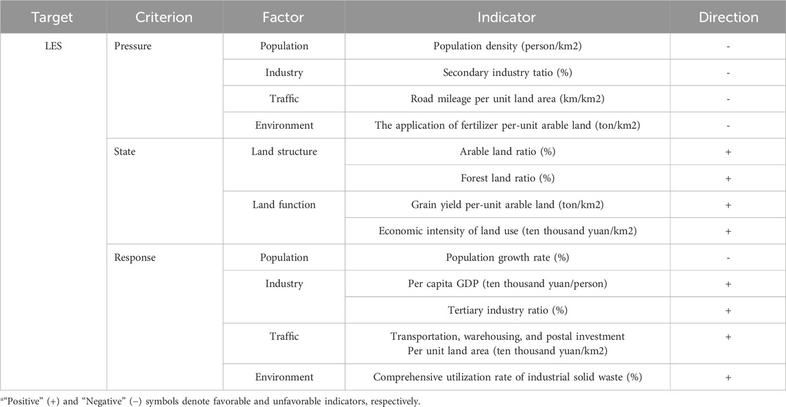
The Pressure-State-Response (PSR) framework, which incorporates the influences and interactions between human activities and the natural environment, is capable of effectively elucidating the causal relationships between the prevailing environmental conditions and the array of environmental challenges. Within the realm of coordinated development, the achievement of breakthroughs mandates a focused approach to pivotal tasks: the management of population trends, the transformation of industries, the enhancement of transportation infrastructure, and the preservation of ecological systems. From the perspective of collaborative development, this paper conducts an indicator system of LES (Table 1) (Guo et al., 2023; Guo, 2022).
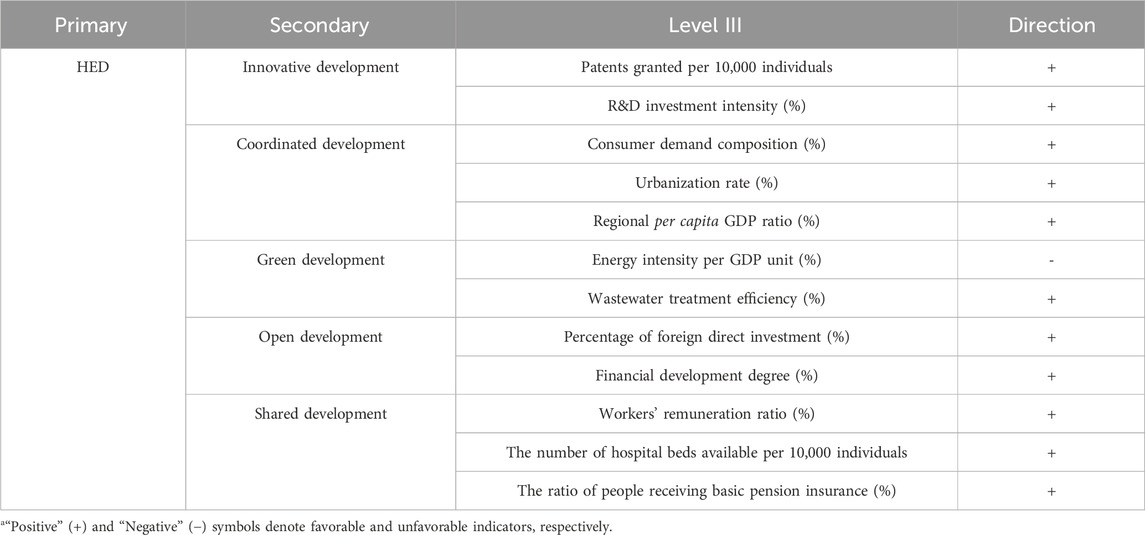
Based on the connotation of HED, this research has formulated an extensive indicator framework tailored to the BTH region, encompassing five integral dimensions: innovative development, coordinated development, green development, open development, and shared development (Table 2) (Guo et al., 2022; Guo, 2022).
The R&D investment intensity is calculated by the ratio of total scientific and technological expenditure to the overall public budget expenditure at the local level. Consumer demand composition is evaluated by calculating the proportion of overall consumer goods retail volume relative to the local GDP. The regional per capita GDP ratio is calculated using the proportion of area-specific per capita GDP relative to the national per capita GDP. The percentage of foreign direct investment is determined by the proportion of actual foreign direct investment relative to the local GDP. Workers’ remuneration ratio is determined by the ratio of the average salary of employees to local GDP.
2.3.2 EW-TOPSIS model
This study first normalizes the data, then determines the weights using the entropy weight method, and finally evaluates LES and HED using the TOPSIS method (Qiao and Cheng, 2016; Chen et al., 2018). The approach is a prevalent selection for conducting multi-objective decision analyses in systems engineering, particularly when dealing with finite schemes. It comprehensively assesses the discrepancy between the ideal state and the practical reality (Yao et al., 2021). LES and HED calculation formulas are Equations 1–8.
Among them,
2.3.3 CCD model
The CCD model operates based on the fundamental principle of capacity coupling, with the coupling coordination degree serving as an indicator of the level of interdependence and mutual influence exhibited by two components within a specified system (Li et al., 2012; Li et al., 2014). The calculation formula are Equations 9–11.
Among them,
2.3.4 Deviation coordination degree model
The deviation coordination model, which rooted in the principle of deviation coefficient, assesses the status or level of harmony among the constituent elements within a system (Ren et al., 2021). The calculation formula are Equations 12–14.
Among them,
2.3.5 Relative development degree model
This study meticulously examines and assesses the relative development magnitude employing the relative development degree model (Liu, 2017). The calculation formula is Equation 15.
Among them,
2.3.6 Spatial autocorrelation analysis model
2.3.6.1 Spatial autocorrelation model
The global Moran’s I is adopted to examine the correlation degree in the overall space, while the local Moran’s I is adopted to detect spatial auto-correlation patterns and localized spatial inconsistencies (Liu, 2020). This study conducted the global Moran’s I and local Moran’s I for the coupling stages and coordination relationships of the two systems. The calculation formula are Equations 16, 17.
Among them,
2.3.6.2 Bivariate spatial autocorrelation model
To gain insights into the spatial clustering and dispersion patterns between LES and HED, we initially leverage the global bivariate Moran’s I index to thoroughly assess their correlation, spatial configurations, and statistical significance from a global standpoint. Subsequently, we employ the local bivariate Moran’s I index to precisely identify specific spatial autocorrelation patterns and any localized spatial variations (Shi, 2019). The calculation formula are Equations 18, 19.
Among them,
3 Results
3.1 Assessment and analysis of LES
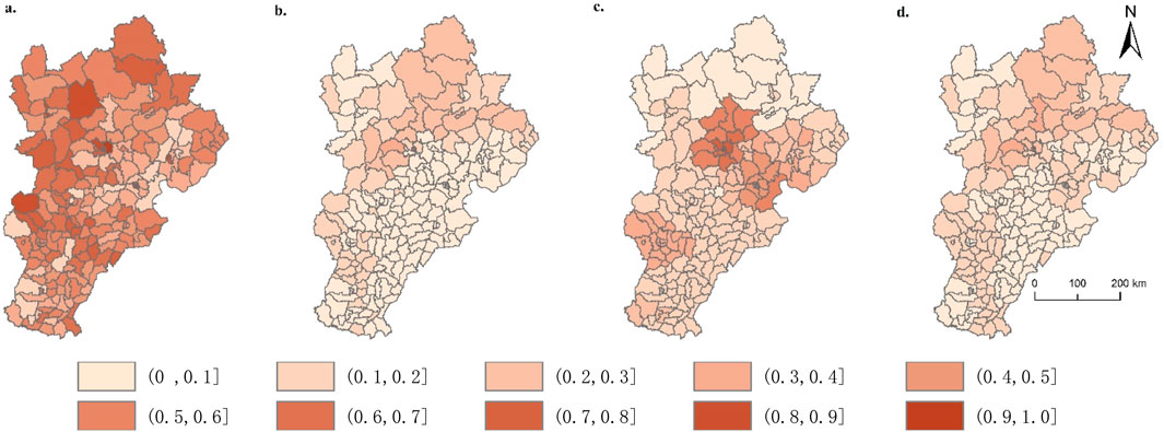
In 2018, the LES index exhibited significant variation, ranging from 0.0560 to 0.6694 in the BTH region (Table 6; Figure 2D). The high ecological security zones are predominantly concentrated in the centers of Beijing and Tianjin, along with the northern cities of Chengde and Zhangjiakou in Hebei Province. Beijing and Tianjin exhibit a relatively high level of economic and social development, with more funds invested in ecological construction. Concurrently, policies such as population evacuation and industrial transfer in Beijing and Tianjin have further improved their LES level. The pressure index of LES ranged from 0.1595 to 0.9140, while the status index ranged from 0.0092 to 0.6599, and the response index exhibited a range from 0.0560 to 0.9387 (Table.6; Figures 2A–C). Among the various regions under the study, Beijing, Tianjin, and Shijiazhuang stand out with remarkably high response indices, which means that these developed areas have effectively catalyzed industrial transformation, strengthened transportation infrastructure, nurtured ecological protection initiatives, and guided population deconcentration. These positive actions have jointly contributed to a significant enhancement in the land ecological response index, bolstering the overall level of LES.
3.2 Assessment and analysis of HED
In 2018, the HED index of the BTH region ranged from 0.0321 to 0.7979, with the trend of “Central Region > Peripheral Regions” (Table 7, Figure 3F). The high-value areas of the HED index are mainly concentrated in the urban areas of Beijing and Tianjin, presenting a clustered structure with Beijing and Tianjin as the core. This manifestation indicates the polarization phenomenon of HED within the BTH region, mainly due to the high development starting point and rapid growth rate of Beijing and Tianjin. The innovative development index of HED ranged from 0.000007 to 0.8197, which in Dongcheng, Xicheng, and Haidian districts in Beijing and the Binhai New Area in Tianjin stands conspicuously above other regions, demonstrating a marked superiority in this crucial metric. The coordinated development index of HED ranged from 0.0673 to 0.7535, with the trend of “Eastern and Southeast Regions > Other Regions” (Table 7; Figure 3B). The green development index of HED ranged from 0.1516 to 0.9681. Notably, the development level of the green development subsystem was observed to be the highest, which is conducive to the overall improvement of HED. The open development index of HED ranged from 0.0006 to 0.9904, which in the regions encompassing Haidian, Changping, Shunyi, Tongzhou, Shijingshan, and Chaoyang districts in Beijing, along with the Binhai New Area and Ninghe District in Tianjin, significantly surpasses other regions. The shared development index of HED ranged from 0.0542 to 0.7342, with the trend of “Central Region.
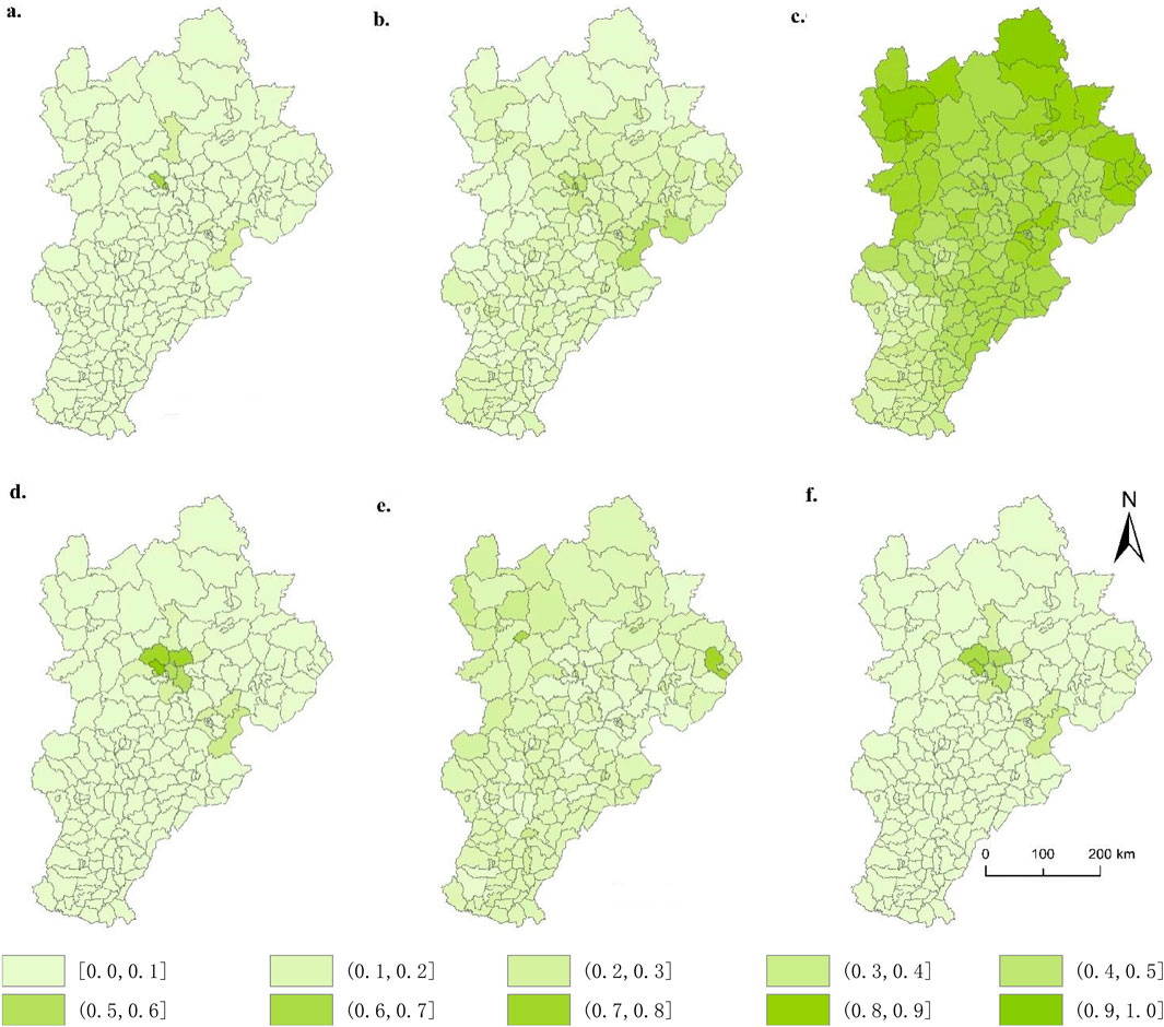
Figure 3. The HED spatial distribution. (A) Innovative. (B) Coordinated. (C) Green. (D) Open. (E) Shared. (F) HED.
3.3 Spatial auto-correlations analysis of LES and HED
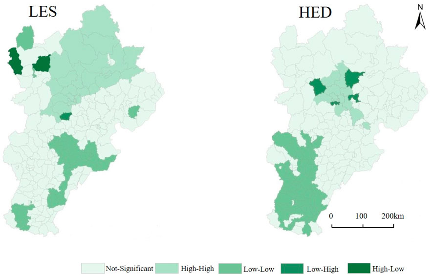
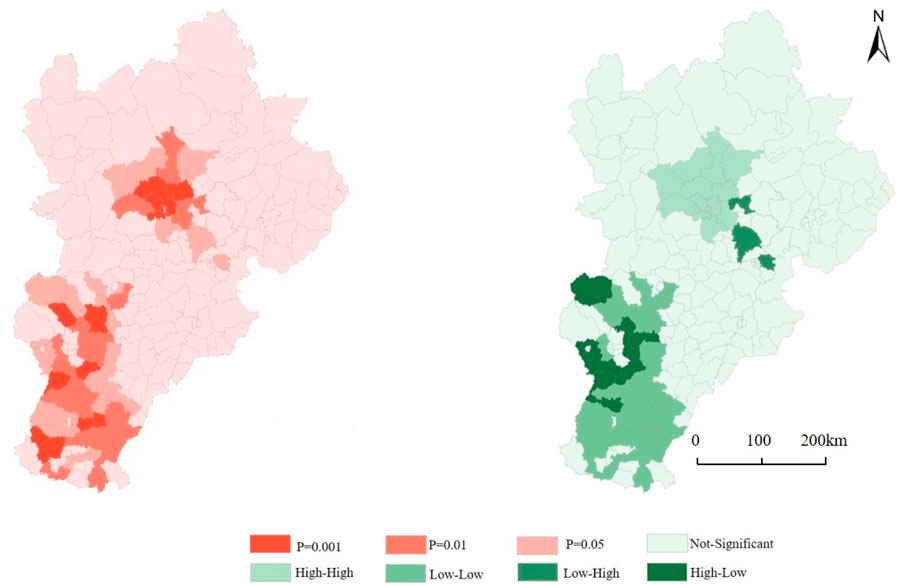
The global univariate Moran’s I analysis revealed that all the Moran’s I indices are positive and exhibit statistical significance at 0.001 level, signifying that both LES and HED existed significantly positive spatial correlations (Figure 4). The global bivariate Moran’s I analysis showed that all Moran’s I indices are positive, with statistical significance at the 0.001 level. The research results found a significant positive spatial correlation between LES and HED, which indicates that as the level of LES increases, the level of HED also increases accordingly.
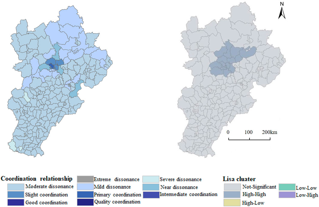
Based on bivariate local spatial autocorrelation analysis, a bivariate LISA clustering map of LES and HED in the BTH region was obtained (Figure 5), which characterizes the local spatial heterogeneity of LES and HED. The spatial clustering patterns in the BTH region are predominantly of the high-high and low-low types. The 15 counties exhibiting a distinct high-high spatial clustering pattern are predominantly situated in Beijing’s districts, including Dongcheng, Xicheng, Chaoyang, Fengtai, Shijingshan, Haidian, Mentougou, Tongzhou, Shunyi, Changping, Daxing, Huairou, Miyun, and Yanqing, as well as the county of Huailai in Zhangjiakou. This is mainly because Beijing is in a strategic opportunity period of reducing development and improving quality and efficiency, as well as a transformation planning period for the management of mountains, waters, forests, fields, lakes, and grasslands. In addition, Huailai County borders Beijing and is an important node for the coordinated development of the Beijing Tianjin Hebei region. It has abundant cultural and tourism resources, and the government continues to promote the development of LES and HED by optimizing the industrial structure, promoting technological innovation, and implementing a series of key projects. The positive interaction between LES and HED has made the region high-high spatial clustering pattern, achieving a win-win situation for LES and HED. The 38 counties exhibiting a low-low spatial clustering pattern are mainly located in Handan, Xingtai, Baoding, and the suburbs of Shijiazhuang. This is mainly due to the fact that the region is located in the southern part of the BTH region, far away from Beijing and Tianjin. In the process of economic and social development, it is difficult to absorb its spillover resources, and the level of HED is relatively low. Meanwhile, compared with the northern part of the BTH region, ecological resources are relatively scarce and the level of LES is not high. However, the high-low and low-high types present a complex situation. Besides, The 11 high-low type counties are mainly located in Gaocheng, Jingxing, Gaoyi, Shenze, Zanhuang, Wuji, Yuanshi, Zhaoxian, Xinle in Shijiazhuang, as well as Neiqiu in Xingtai City and Fuping in Baoding. The LES in these regions is considerably higher than the HED, exhibiting a substantial disparity between the two, which indicates that the development level of LES and HED in the Shijiazhuang area is significantly different from that in the Beijing Tianjin area, mainly due to geographical location, industrial structure, technological innovation and other factors, the development level of HED is relatively backward. There are only a few low–high types counties mainly located in Dongli and Wuqing of Tianjin, as well as Sanhe of Langfang. The LES in these regions is slightly higher than HED, and the difference between the two is small. These regions are located between Beijing and Tianjin, and due to the spillover of resources such as population, industry, and transportation, they have promoted the development of HED and gradually synchronized with LES.
3.4 The spatial characteristics of coupling degree and coordination degree
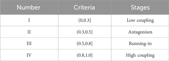
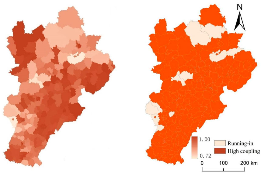
Based on ArcGIS software, the spatial distribution of the coupling degree and coordination degree was drawn in 2018, as shown in Figures 6, 7. Generally, the spatial features of the coupling degree in the BTH region are as follows: the coupling degree of LES and HED ranged from 0.72 to 1.00, in which most of the areas are in the high coupling stage (Figure 6), which indicates that the LES and HED systems are closely related and interdependent.
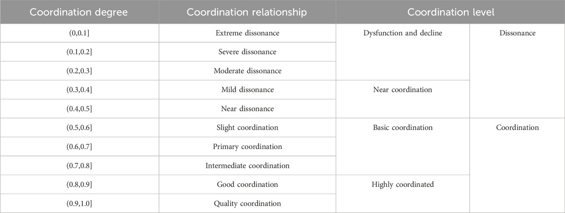
In general, the spatial features of the coordination degree of LES and HED in the BTH region are presented in Figure 7. First, the coordination degree of LES and HED ranged from 0.1922 to 0.6268, including six coordination relationships: primary coordination, slight coordination, near dissonance, mild dissonance, moderate dissonance, severe dissonance. Second, the central region serves as a focal point for high-value regions, while the surrounding areas are predominantly populated by low-value regions. Among them, the highest coordination degree is 0.6268 in Haidian of Beijing, which belongs to the primary coordination relationship. The slight coordination relationship is mainly distributed in six districts of Beijing, including Xicheng, Changping, Dongcheng, Shunyi, Chaoyang, and Shijingshan. Third, most counties in the BTH region are at a dissonance level. The near dissonance areas are mainly distributed in Mentougou, Huairou, and Tongzhou in Beijing, as well as Binhai New Area in Tianjin. The mild dissonance is mainly distributed in most areas of Chengde, the outskirts of Beijing, and Tianjin, as well as in Zhulu of Zhangjiakou and Laiyuan of Baoding. The moderate dissonance areas significantly exceed the quantity of other categories. The spatial distribution is relatively concentrated in Hebei and Tianjin. Fourth, regarding quantity, the severe dissonance areas are comparatively few and only appeared in Qiaoxi of Xingtai, Quyang of Baoding, Shexian, and Fengfeng Mining Area of Handan. In addition, the Moran'I index reflects a positive correlation between the coupling coordination degree of the two systems in county-level spatial distribution, indicating a clear spatial agglomeration trend. The local autocorrelation analysis further emphasizes that high-concentration areas are mainly distributed in Beijing.
3.5 Analysis of coordinated development types
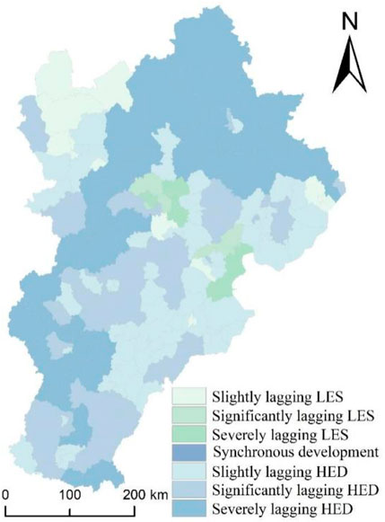
The relative development model helps identify the reasons for the inconsistency between regional LES and HED. Based on the relative development degree model, the spatial distribution of regional coordinated development types is shown in Figure 8. First, there were six coordinated development types, including severely lagging HED, significantly lagging HED, slightly lagging HED, severely lagging LES, significantly lagging LES, slightly lagging LES. Second, the number of lagging HED areas, including 179 counties, is the largest compared to lagging LES. Among them, the slightly lagging HED is mainly distributed in 64 counties, accounting for 32% of the total, significantly lagging HED is distributed in 66 counties, accounting for 33%, the distribution of severely lagging HED is in 49 counties, accounting for 24.5%. Among them, the area of slightly lagging HED are concentrated in the North China Plain and Hilly Area, as well as the area of significantly lagging HED. The areas of severely lagging HED are concentrated in the Yanshan Mountains and Taihang Mountains. Geographical factors, especially altitude, have become a key factor affecting the degree of lag. Third, the lagging LES areas include 21 counties. The distribution area includes some counties and districts in Beijing and Tianjin, as well as the Zhangjiakou area in Hebei. Next, we need to gradually improve the level of land ecological security in Beijing, Tianjin, and Zhangjiakou regions.
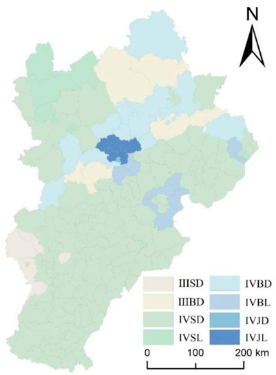
After a thorough analysis involving the various stages of coupling, intricate coordination relationships, and diverse development types, the study offers a refined classification of the composite models for coupled and coordinated development (Figure 9). From the perspective of spatial distribution, the coupling and coordinated development types of LES and HED in the BTH region exhibit prominent spatial differentiation characteristics. Eight varied types of coupled and coordinated development have been identified, including Running in—dysfunction and decline—lagging HED (IIISD), Running in—near coordination—lagging HED (IIIBD), High coupling—dysfunction and decline—lagging HED (IVSD), High coupling—dysfunction and decline—lagging LES (IVSL), High coupling—near coordination—lagging HED (IVBD), High coupling—near coordination—lagging LES (IVBL), High coupling—basic coordination—lagging HED (IVJD), and High coupling—basic coordination—lagging LES (IVJL). (1) The IIISD type is mainly distributed in the western part of Shijiazhuang, where the coupling and coordination are at the lowest level in the study area, lower than other regions, and the level of HED lags behind. (2) The IIIBD type is mainly distributed in the central and southern parts of Chengde, as well as the adjacent areas of Beijing and Baoding. The study area has the lowest coupling degree, relatively low coordination degree, and lagging HED level. (3) The IVSD type has the highest coupling degree and the lowest coordination degree and lags behind in HED, including 153 counties, distributed in most counties except Beijing, Tianjin, and Chengde. The number of IVSD types is the largest compared to other types, as shown explicitly, the quantity of IVSD type accounts for 76.00%, and the area accounts for 59.02%. Among the 153 IVSD-type counties, there are 22 counties in Baoding, 19 counties in Xingtai, 18 counties in Handan, 17 counties in Shijiazhuang, 14 counties in Tangshan, 14 counties in Cangzhou, 11 counties in Tianjin, 11 counties in Hengshui, 10 counties in Langfang, 9 counties in Zhangjiakou, 4 counties in Qinhuangdao, and 3 counties in Chengde. (4) The IVSL type is mainly distributed in the northern part of Zhangjiakou, with the highest coupling degree, lowest coordination degree, and lagging LES. (5) The IVBD type is mainly distributed in high-altitude areas of Chengde and Beijing, with the highest coupling degree, lowest coordination degree, and lagging HED. (6) The IVBL type is mainly distributed in some areas of Beijing, Tianjin, and Qinhuangdao, with the highest coupling degree, lowest coordination degree, and LES lag. (7) The IVJD type is mainly distributed in Dongcheng District and Xicheng District of Beijing, with the highest coupling degree, high coordination degree, and lagging HED. (8) The IVJL type is mainly distributed in Changping District, Shunyi District, Haidian District, Chaoyang District, and Shijingshan District of Beijing, with the highest coupling degree, high coordination degree, and lagging LES.
4 Discussion
In recent years, a growing number of scholars have studied ecological economics issues from a spatial perspective, such as climate change, carbon emissions, energy consumption, etc. (Ren et al., 2023; Ren et al., 2024a; Ren et al., 2024b). This paper aims to complement the existing literature on LES and HED. The scale effect is a crucial aspect of spatial modeling, typically addressed by conducting a thorough analysis of high-resolution data (Dong et al., 2020). From the standpoint of fostering coordinated development in the BTH region, this study constructs an evaluation index system for LES–HED systems with counties as evaluation units to improve the accuracy and precision of research results. According to our research, At the scale of counties, the LES index spanned a range from 0.0560 to 0.6694, and the HED index ranged from 0.0321 to 0.7979. Previous studies have also confirmed the spatial agglomeration effect between ecological security and economic development (Ran et al., 2024; Meng et al., 2023). Further research also finds that the15 counties exhibiting a distinct high-high spatial clustering pattern are predominantly situated in Beijing, and the 38 counties exhibiting the low-low clustering type are primarily situated in Shijiazhuang, Handan, Xingtai, and Baoding.
The study extends the current literature by researching the coordinated relationship between LES and HED at the county scale. Based on the two different coordination principles of dispersion coefficient and capacity coupling, a comprehensive analysis is conducted adopting the CCD model and dispersion coordination model, and a relatively comprehensive systematic evaluation is made on the coordination relationship between the two systems. The research results show significant differences in the coordination status among different counties in the BTH region. Notably, the degrees of coordination in the central regions tend to be slightly elevated compared to other regions. Among them, the highest coordination degree is 0.6268 in Haidian of Beijing, which belongs to the primary coordination relationship. The slight coordination relationship is mainly distributed in six districts of Beijing, including Xicheng, Changping, Dongcheng, Shunyi, Chaoyang, and Shijingshan. The moderate dissonance areas constitute the largest proportion among all the other categories. The spatial distribution is relatively concentrated in Hebei and Tianjin. Thereby, it can be seen that the counties and districts in Beijing are in a coordinated state, leading which in Tianjin and Hebei. Previous research has found that characteristic industries, high-tech, financing costs, labor costs, effective mechanisms, and other factors have become important driving factors for the coordinated development of compound synergy (Laura et al., 2020; Li et al., 2022; Meng et al., 2023; Li et al., 2014; Ren et al., 2024a; Zhang et al., 2024). This is mainly because Beijing has moved away from the stage of solely pursuing economic growth rate, and has accelerated industrial transformation and upgrading, especially in Haidian District, which is dominated by high value-added, low pollution high-tech industries and advanced production and service industries. However, due to the low coordination level between the LES and HED systems in Hebei, which account for 87% of the region’s area, the overall coordination level of the region has been lowered. Overall, the coordinated development level of the BTH region is relatively low.
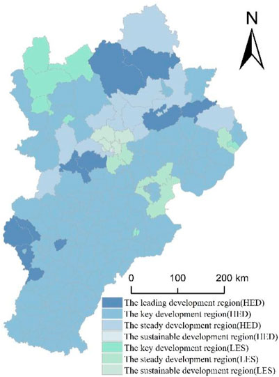
Compared with previous studies (Guo et al., 2023), this study improved the accuracy when defining the functional regions of the research area, which helps to develop differentiated management strategies. Through county-level research, the development types have been expanded from Category 3 to Category 6. At the same time, by integrating the coupling stage, coordination relationship, and development type, the functional regions will be expanded from Category 6 to Category 7 (Figure 10). (1) The leading development region (HED) includes 11 counties located in the central and southern parts of Chengde, adjacent areas of Beijing and Baoding, and the western part of Shijiazhuang. The research area has the lowest coupling degree, relatively low coordination degree, and lagging HED level. (2) The key development region (HED) includes 153 counties, distributed in most counties except Beijing and Chengde. These areas exhibit a near discordance, with the HED experiencing a minor lag. In the future, these areas should be vital to promoting HED and coordinated development. (3) The steady development region (HED) includes 14 counties, mainly distributed in high-altitude areas of Chengde and Beijing, as well as several counties in Zhangjiakou, Baoding, and Qinhuangdao. The coordination relationship in the region has begun to shift from imbalance to coordination, but it has yet to reach the state of coordination. It is necessary to promote HED and steadily coordinate the development of the two systems. (4) The sustainable development region (HED) includes Dongcheng and Xicheng in Beijing. The coordination relationship in the region is good, and it only needs to promote HED continuously. (5) The key development region (LES) includes 9 counties distributed in Zhangjiakou, Qinhuangdao, and Cangzhou. This area is critical to improving the level of LED, and it is necessary to optimize and enhance the coordination relationship. (6) The steady development region (LES) includes 7 counties in Beijing, Tianjin, and Qinhuangdao. As regional coordination gains momentum, it becomes imperative to progressively elevate the LES level and swiftly pivot toward achieving coordinated development. (7) The sustainable development region (LES) includes 5 counties distributed in Chaoyang, Shijingshan, Haidian, Shunyi, and Changping of Beijing. The region has a good relationship of coordination and only needs to improve the level of LES continuously.
Ecological security and economic development are key factors for regional sustainable development (Kurepina et al., 2020). To boost ecological security and economic development, this study suggests that decision-makers and city officials formulate different and targeted strategies. Based on the above results, the paper provides the following policy recommendations. (1)Enhance the synergy within the Beijing-Tianjin-Hebei (BTH) region by refining the collaborative mechanisms that bridge the HED systems. Despite the critical importance, these systems currently exhibit a suboptimal level of coordinated development. To solve the above problem, it is essential to implement robust communication and collaboration frameworks that transcend administrative boundaries, facilitate the fluid movement of productive factors, strategically guide industrial relocation, and promote technological and talent exchange. A jointly effort should be directed towards significantly elevating the collaborative advancement of LES and HED systems in Hebei province, with the overarching goal of enhancing the collective coordinated development level of these systems across the BTH region. (2)Take elevate the enhancement of the HED level as a primary objective. For this purpose, we must concurrently foster regional innovation, embrace open development, and ensure coordinated growth in Hebei, thereby elevating the sophistication of subsystem development. Concurrently, we should concentrate our efforts on the leading/key/steady development regions (HED) to refine the interplay between the LES and HED systems. We can optimize this coupling by improve the HED level thus facilitating a harmonious and progressive evolution of both systems. (3) Enhance the LES level in a steadfast and progressive manner. Therefore, it is imperative to refine the ecological condition of the land and augment governmental responsiveness, which involves enriching the array of response strategies and elevating the LES level by optimizing the ecological status and response subsystems. On the other hand, strategic land ecological conservation initiatives will be strategically deployed in the key/steady development regions (LES). These initiatives are designed to bolster the harmonious advancement of LES and HED within the area, thereby effectuating a synergistic enhancement of both systems.
The key contributions of this paper are enumerated as follows. First, a comprehensive systematic evaluation of the coordination relationship between the two systems was conducted based on the CCD model and dispersion coordination model at the county scale, which is helpful in presenting the real situation scientifically and accurately. Second, the scientific measurement approach is employed to divide the eight composite types and the seven functional regions in the BTH area, which helps promote the positive relationship of LES and HED, achieving coupling and coordinated development of the two systems. The paper’s linkage to extant theories lies in its nuanced exploration of the interplay between LES and HED, offering a profound reinterpretation of economic ecology theory. Ecological economics underscores the intricate interplay between human socio-economic activities and the corresponding alterations in resources and the environment, emphasizing the seamless integration of economics and ecology.
This paper offers a compelling empirical case study, significantly enhancing the theoretical foundations of ecological economics. Besides, this paper also provides a beneficial exploration of the coordinate development path for HED and LES of the BTH region, and provides a theoretical reference for the analysis of the regional sustainable development paths. However, due to data limitations and imperfect knowledge, this study still has room for further improvement in the modeling process. For example, this study lacks comparative research with other regions or models, resulting in certain limitations in the research findings. In future research, comparative studies will be conducted with regions such as the Yangtze River Delta and the Guangdong Hong Kong Macao Greater Bay Area, which will help to comprehensively elaborate the relationship between ecological security and economic development in collaborative development areas, as well as has important theoretical and practical significance for promoting regional sustainable development.
5 Conclusion
In this study, we adopted the methods of EW-TOPSIS, coupling coordination degree, deviation coordination degree, and relative development degree to assess the development level, coupling stages, and coordination relationships of LES and HED, and analyze their spatial distribution characteristics at the county scale. Our study puts forward the method of dividing functional regions from the perspective of LES-HED and sustainability. Further, it proposes the development paths and spatial development goals of different functional regions. Based on the comprehensive analysis, this study conducted the following four conclusions.
First, the polarization phenomenon of LES and HED is pronounced within the BTH region, with a clear positive spatial correlation between the two systems. Notably, the levels of LES and HED in Beijing and Tianjin are markedly higher than Hebei. Spatially, LES exhibits a pattern of higher concentrations in the northern areas compared to other regions, whereas HED shows a pattern of higher concentrations in the central regions relative to other areas. The predominant spatial clustering pattern for both systems across the study area is one of high-high clustering.
Second, at the county level across the BTH region, LES and HED predominantly exist in a state of high coupling, characterized by a moderate degree of imbalance. The coordination levels present a spatial trend where the central regions surpass other areas, with Beijing and Tianjin exhibiting significantly higher coordination than Hebei. Spatial autocorrelation analysis reveals a pronounced positive spatial correlation in coordination levels, predominantly concentrated in Beijing. This trend is primarily attributed to Beijing’s current strategic emphasis on quality over quantity in development, specifically focusing on enhancing the governance of its natural environment, including mountains, waters, forests, fields, lakes, and grasslands, which fosters effective coordination between LES and HED.
Third, Reiterating the findings, the BTH region demonstrates pronounced spatial heterogeneity in its coordinated development, which can be delineated into seven distinct functional zones. These zones encompass eight unique types, with the IVSD type being the most extensively distributed, marked by the highest degree of coupling and the lowest degree of coordination, primarily attributed to the underdevelopment of HED. In terms of coupling stages, coordination relationships, and developmental types, the study area is stratified into seven functional zones. Significantly, the key development region (HED) occupies the largest area, covering 153 counties, predominantly located in the regions surrounding Beijing, Tianjin, and Chengde.
Fourth, implementing a targeted strategy can facilitate the synergistic advancement of LES and HED. Recommendations are proposed include establishing a collaborative framework for the BTH region, enhancing the innovation, openness, and coordination of HED, prioritizing the advancement of HED in the leading/key/steady development regions (HED), incresing the prominence and responsiveness of LES, and strategically deploying land ecological engineering in the key/steady development regions (LES). These measures aim to refine the development trajectory of both LES and HED within the research area, thereby augmenting the coordination between these two systems.
Data availability statement
The original contributions presented in the study are included in the article/supplementary material, further inquiries can be directed to the corresponding author.
Author contributions
XZ: Conceptualization, Funding acquisition, Writing–original draft. DG: Conceptualization, Data curation, Methodology, Software, Writing–review and editing. YT: Funding acquisition, Writing–review and editing. YC: Writing–review and editing.
Funding
The author(s) declare that financial support was received for the research, authorship, and/or publication of this article. This work was funded by the Hebei Social Science Fund (NO. HB24GL010).
Conflict of interest
The authors declare that the research was conducted in the absence of any commercial or financial relationships that could be construed as a potential conflict of interest.
Publisher’s note
All claims expressed in this article are solely those of the authors and do not necessarily represent those of their affiliated organizations, or those of the publisher, the editors and the reviewers. Any product that may be evaluated in this article, or claim that may be made by its manufacturer, is not guaranteed or endorsed by the publisher.
Abbreviations
BTH, Beijing-Tianjin-Hebei; CCD, Coupling Coordination Degree; EW-TOPSIS, the Entropy Weighted Technique for 0rder Preference by Similarity to Ideal Solution; ED, Economic Development; LES, Land Ecological Security; HED, High-quality Economic Development.
References
Bilgen, S., and Sarikaya, I. (2015). Exergy for environment, ecology and sustainable development. Renew. Sustain. Energy Rev. 51, 1115–1131. doi:10.1016/j.rser.2015.07.015
Chen, Y., Yang, Q., Yang, R., and Zeng, L. (2018). Evaluation of land ecological security based on entropy weighted matter-element model: a case of Jiangjin District, Chongqing. Arid. Land Geogr. 41 (01), 185–194. doi:10.13826/j.cnki.cn65-1103/x.2018.01.023
Costanza, R. (1978) “Energy costs of goods and services in 1 967 including solar energy inputs and labor and government service feedbacks,” in Center for advanced computation. Urbana, IL: University of Illinois at Urbana-Champaign, 46.
Dai, J. (2019). Analysis on the coupling and coordination of land ecological security and economic development in Hunan province. Rural. Econ. Sci.Technol 30, 42–45.
Dong, G., Ma, J., Lee, D., Chen, M., Pryce, G., and Chen, Y. (2020). Developing a locally adaptive spatial multilevel logistic model to analyze ecological effects on health using individual census records. Ann. Assoc. Am. Geogr. 110, 739–757. doi:10.1080/24694452.2019.1644990
Feng, Y., Yang, Q., Tong, X., and Chen, L. (2018). Evaluating land ecological security and examining its relationships with driving factors using GIS and generalized additive model. Sci. Total Environ. 633, 1469–1479. doi:10.1016/j.scitotenv.2018.03.272
Guo, D., Wang, D., Zhong, X., and Yang, Y. (2022). Coupling coordination of land ecological security and high-quality economic development in the beijing-tianjin-hebei region. Jilin University. Doctoral dissertations. doi:10.13546/j.cnki.tjyjc.2022.15.023
Guo, D., Wang, D., Zhong, X., and Yang, Y. (2022). Evaluation of high quality development and its obstacle indicators diagnosis in the beijing–tianjin–hebei region. Statistics and Decis. 38 (15), 122–126. doi:10.13546/j.cnki.tjyjc.2022.15.023
Guo, D., Wang, D., Zhong, X., Yang, F., Yang, Y., and Jia, H. (2023). The coupling coordination and interaction mechanism of land ecological security and high-quality economic development in the beijing–tianjin–hebei region. Sustainability 15, 15670. doi:10.3390/su152115670
Guo, D., Wang, D., Zhong, X., Yang, Y., and Jiang, L. (2021). Spatiotemporal changes of land ecological security and its obstacle indicators diagnosis in the Beijing–Tianjin–Hebei region. Land 10 (7), 706. doi:10.3390/land10070706
He, R., Rao, Q., Yang, H., and Zhang, X. (2020). Evaluation of the relationship between land ecological security and economic development in Anhui province based on the coupling coordination model. J. Heilongjiang Bayi Agric. Univ. 32, 119–124+132.
He, Z., Shang, X., and Zhang, T. (2021). Spatiotemporal evaluation and driving mechanism of land ecological security in yan’an, a typical hill-gully region of China’s loess plateau, from 2000 to 2018. Forests 12, 1754. doi:10.3390/f12121754
Hou, X., and Jiang, Y. (2020). Evaluation of the relationship between land ecological security and economic development based on the coupling coordination degree in Jieyang City, China. J. Hainan Norm. Univ. (Nat. Sci.) 33, 446–452. doi:10.13546/j.cnki.tjyjc.2022.15.023
Igaliyeva, L., Yegemberdiyeva, S., Utepkaliyeva, K., and Bakirbekova, A. (2020). Development of economic mechanism for ensuring ecological security in Kazakhstan. Int. J. Energy Econ. Policy 10 (04), 240–250. doi:10.32479/ijeep.9634
Kurepina, N., Berikova, N., Shovaeva, M., and Mandzhieva, D. V. (2020). Ecological and economic security as a factor of sustainable rural development. E3S Web Conf. 161, 01007. doi:10.1051/e3sconf/202016101007
Li, H., Nan, L., and Li, S. (2017). Evaluation of land ecological security based on panel data cluster analysis: a case study in Shanxi province. Areal Res. Dev. 36, 136–141.
Li, J., Wang, X., Miao, C., and Liu, J. (2014). The coordination analysis about level and quality of urbanization: a case study of Henan Province. Econ. Geogr. 34, 70e77. doi:10.15957/j.cnki.jjdl.2014.10.041
Li, X., Zhou, X., and Yan, K. (2022). Technological progress for sustainable development: an empirical analysis from China. Econ. Analysis Policy 76, 146–155. doi:10.1016/j.eap.2022.08.002
Li, Y., Zhou, Y., Shi, Y., and Zhu, X. (2012). Investigation of a coupling model of coordination between urbanization and the environment. J. Environ. Manag. 98, 127–133. doi:10.1016/j.jenvman.2011.12.025
Liu, B. (2017). Research on coordination development of New urbanization and land health utilization in jilin province. Jilin University. Doctoral dissertations.
Liu, D. (2020). The research on coordinative development between manufacturing and producer services in northeast China. Northeast Normal University. Doctoral dissertations.
Meng, L., Yang, R., Sun, M., Zhang, L., and Li, X. (2023). Regional sustainable strategy based on the coordination of ecological security and economic development in yunnan province, China. Sustainability 15, 7540. doi:10.3390/su15097540
Müller-Fürstenberger, G., and Wagner, M. (2007). Exploring the environmental Kuznets hypothesis: theoretical and econometric problems. Ecol. Econ. 62, 648–660. doi:10.1016/j.ecolecon.2006.08.005
Ni, R., Guan, H., Wang, Y., and Liu, Y. (2024). Spatial differences, distribution dynamics and driving factors of the synergy between marine ecological security and high-quality development in three major marine economic circles of China. Front. Mar. Sci. 11, 1338154. doi:10.3389/fmars.2024.1338154
Pörtner, H., Roberts, D., Adams, H., et al. (2022). Climate change 2022: impacts, adaptation and vulnerability. Cambridge, United Kingdom and New York, NY: Cambridge University Press. doi:10.1017/9781009325844.002
Qiao, H., and Cheng, W. (2016). Ecological security evaluation of land based on entropy weight matter-element model. Chin. J. Soil Sci. 47 (02), 302–307. doi:10.19336/j.cnki.trtb.2016.02.07
Ren, D., Cao, G., and Long, S. (2021). Analysis of the coordination degree of social development in China based on the framework of HDI. J. Quantitative and Technol. Econ. 38 (06), 88–106. doi:10.13653/j.cnki.jqte.2021.06.004
Ren, X., Li, Y., Ji, Q., and Zhai, P. (2023). Climate policy uncertainty and the green bond market: fresh insights from the QARDL model. Appl. Econ. Lett., 1–6. doi:10.1080/13504851.2023.2275643
Ren, X., Xiao, Y., Xiao, S., Jin, Y., and Taghizadeh-Hesary, F. (2024b). The effect of climate vulnerability on global carbon emissions: evidence from a spatial convergence perspective. Resour. Policy 90, 104817. doi:10.1016/j.resourpol.2024.104817
Ren, X., Yang, W., and Jin, Y. (2024a). Geopolitical risk and renewable energy consumption: evidence from a spatial convergence perspective. Energy Econ. 131, 107384. doi:10.1016/j.eneco.2024.107384
Shi, G. (2019). Study on the coupling and coordination relation between population urbanization and education urbanization in Chinese provinces. Anhui University. Doctoral dissertations.
Shi, T., Yang, S., Zhang, W., Zhou, Q., et al. (2020). Coupling coordination degree measurement and spatiotemporal heterogeneity between economic development and ecological environment –Empirical evidence from tropical and subtropical regions of China. J. Clean. Prod. 244, 118739. doi:10.1016/j.jclepro.2019.118739
Sui, B., Sharma, S., Yao, L., Ni, G., and Chang, C. (2024). Does aging affect renewable energy? The role of extreme events and economic development. Energy Econ. 133, 107491. doi:10.1016/j.eneco.2024.107491
Sun, M., Li, X., Yang, R., Zhang, Y., Zhang, D., et al. (2020). Comprehensive partitions and different strategies based on ecological security and economic development in Guizhou Province, China. J. Clean. Prod. 274 (1), 122794. doi:10.1016/j.jclepro.2020.122794
Wang, H., Qin, F., and Zhang, X. (2018). A spatial exploring model for urban land ecological security based on a modified artificial bee colony algorithm. Ecol. Inf. 50, 51–61. doi:10.1016/j.ecoinf.2018.12.009
Wang, J., Wei, X., and Guo, Q. (2018). A three-dimensional evaluation model for regional carrying capacity of ecological environment to social economic development: model development and a case study in China. Ecol. Indic. 89, 348–355. doi:10.1016/j.ecolind.2018.02.005
Wang, L., Chang, J., He, B., Guo, A., and Wang, Y. (2023). Analysis of oasis land ecological security and influencing factors in arid areas. Land Degrad. and Dev. 34, 3550–3567. doi:10.1002/ldr.4702
Wang, M. (2022). Comparison and selection of coordination degree models. Statistics and Decis. 12, 004. doi:10.13546/j.cnki.tjyjc.2022.12.004
Wang, P., and Zeng, H. (2013). The relationship between economic growth and urban land ecological security based on the model of the EKC. Ecol. Environ. Sci. 22, 351–356. doi:10.16258/j.cnki.1674-5906.2013.02.001
Wen, M., Zhang, T., Li, L., Chen, L., and Yuan, L. (2021). Assessment of land ecological security and analysis of influencing factors in chaohu lake basin, China from 1998–2018. Sustainability 13, 358. doi:10.3390/su13010358
Wu, L., and Xie, B. (2019). The variation differences of cultivated land ecological security between flatland and mountainous areas based on LUCC. Plos One 14 (8), e0220747. doi:10.1371/journal.pone.0220747
Yang, K., Li, R. K., and Zhang, H. X. (2016). Assessment and research of economic growth in ecological zones and urban land ecological safety. Acta Agric. Jiangxi 28, 109–113. doi:10.19386/j.cnki.jxnyxb.2016.01.022
Yang, R. Y., Du, W. Y., and Yang, Z. S. (2021). Spatiotemporal evolution and influencing factors of urban land ecological security in yunnan province. Sustainability 13, 2936. doi:10.3390/su13052936
Yao, Z., Cai, H., Zhang, X., Zeng, Y., and Shao, H. (2021). Spatio-temporal differentiation and obstacle factors of land ecological security in fuliang county based on CRITIC-TOPSIS model. Resour. Environ. Yangtze Basin 30 (10), 2452–2463. doi:10.11870/cjlyzyyhj202110013
Zhang, K., Li, H., Zhou, J., Guo, Z., and Liu, J. (2021). Coupling and coordination analysis on land eco-security and economic development of counties in the Changsha-Zhuzhou-Xiangtan Region. Sci. Technol. Manag. Land Resour. 38, 1–17. doi:10.3969/j.issn.1009-4210.2021.01.001
Zhang, L., Sun, H., Pu, T., Sun, H., and Chen, Z. (2024). Do green finance and hi-tech innovation facilitate sustainable development? Evidence from the Yangtze River Economic Belt. Econ. Analysis Policy 81, 1430–1442. doi:10.1016/j.eap.2024.02.005
Keywords: land ecological security (LES), high-quality economic development, Beijing-Tianjin-Hebei (BTH) region, coordinated relationship, measuring
Citation: Zhong X, Guo D, Tang Y and Chuai Y (2025) Measuring coordination between land ecological security and high-quality economic development: a case of the Beijing-Tianjin-Hebei region. Front. Environ. Sci. 13:1498103. doi: 10.3389/fenvs.2025.1498103
Received: 18 September 2024; Accepted: 02 January 2025;
Published: 05 February 2025.
Edited by:
Xiaohang Ren, Central South University, ChinaCopyright © 2025 Zhong, Guo, Tang and Chuai. This is an open-access article distributed under the terms of the Creative Commons Attribution License (CC BY). The use, distribution or reproduction in other forums is permitted, provided the original author(s) and the copyright owner(s) are credited and that the original publication in this journal is cited, in accordance with accepted academic practice. No use, distribution or reproduction is permitted which does not comply with these terms.
*Correspondence: Dongyan Guo, ZHktZ3VvQGhvdG1haWwuY29t; Yandong Tang, dGFuZ3lhbmRvbmdAY2lkcC5lZHUuY24=
 Xiaoyong Zhong1,2
 Dongyan Guo