 Lina Ke1
 Lei Wang
 Yao Lu
 Qin Tan
- 1School of Geography, Liaoning Normal University, Dalian, China
- 2National Marine Environmental Monitoring Center, Dalian, China
- 3School of Economics and Humanities, Jiangsu Vocational College Agriculture and Forestry, Zhenjiang, China
The acceleration of urbanization and development of marine resources has led to the imbalance of land structure, which threatens the sustainable development of the human living environment. Exploring the spatial distribution patterns of land-sea and its spatio-temporal evolution characteristics is an important initiative to resolve conflicts and optimise the spatial structure of land-sea use. Taking the Liaoning Coastal Economic Belt as an example, this paper constructs a system to measure the value of Production-Living-Ecological Functions (PLEF) of the coastal zone and realizes the identification of Production-Living-Ecological Spaces (PLES) and the division of their combination patterns. At the same time, it analyses the spatio-temporal evolution of PLES using land use transfer matrix, center of gravity transfer and standard deviation ellipse models and explores the interaction mechanism of PLES from the perspective of land-sea coordination. The results show that: (1) The production and living spaces on land are concentrated near the coastline, and the ecological space is mainly distributed in the mountainous forest area. The sea is dominated by the production space, and the living and ecological spaces occupy a relatively small proportion. (2) While the land has significant multifunctionality, the sea has a single PLEF, with the production function dominating and accounting for more than 90%. (3) In the period 2005–2010, the frequency of mutual transformation of the different PLES was the highest. The increase is mainly in the living space on land and the production space at sea. (4) From 2005 to 2010, the patterns of land and sea PLES changed significantly, and from 2010 to 2020, they were relatively stable. This study analyses the spatial structure of land-sea from the perspective of spatial multifunctionality and proposes optimization schemes based on land-sea interactions, which can provide decision support for the identification and optimization of coastal zone space and sustainable development.
1 Introduction
With the rapid advancement of industrialization and urbanization, the spatial pattern of urban land in China has undergone drastic changes (Zhang and Miao, 2020; Song et al., 2021). At the same time, it also leads to the extensive use of land resources, environmental pollution, urban-rural development imbalance and other problems. At different spatial scales, there are contradictions between people and nature, between production and living activities, and within natural ecosystems (Li et al., 2020; Kuang et al., 2021; Liu and Qin, 2023; Zong et al., 2021). In 2012, China first put forward the PLES land management goal of “building an intensive and efficient production space, a livable and moderate living space, and a beautiful ecological space”. The national land development pattern based on PLES is the basis for adjustment and optimization of the national land spatial structure, and provides an important reference basis for resolving the contradictions among urban social and economic development, ecological environmental protection, and production and living boundaries (Zhang et al., 2015; Yang et al., 2018; Wang et al., 2020; Jiang et al., 2022), and is of great scientific significance for China’s national land spatial planning and governance practice.
At present, researches on PLES are mainly divided into connotation and concept (Huang et al., 2020; Duan et al., 2023; Zhang et al., 2024), recognition and division (Li and Fang, 2016; Liu et al., 2017; Duan et al., 2021), pattern and evolution (Li et al., 2022; Zhang and Li, 2022; Zhang et al., 2023), conflict and optimization (Zou et al., 2021; FU et al., 2022; Liao et al., 2022), etc. As for the connotation of PLES, Chinese academic circles have formed a relatively unified interpretation mainly from the perspective of different products or services provided (Zhu et al., 2015; Huang et al., 2017; Huang et al., 2020), holding that “production space refers to the space whose main function is to provide agricultural, industrial and service products”; “Living space is a space with the main function of providing human living, consumption, leisure and entertainment”; “Ecological space refers to a space whose main function is to provide ecological products or ecological regulation and protection.” There is no clear explanation of the concept of PLES at the international level, but modern western scholars have always considered PLEF comprehensively in the relevant research and application of urban planning (Frankhauser et al., 2018). British scholars advocate the formulation of national spatial strategic planning from three aspects: economy, society and environment (Wang, 2016). The spatial planning of the United States gradually aims to solve the contradictions among various types of planning, emphasizing flexibility, regionalism and functional complementarity, and forming a multi-dimensional and orderly planning framework (Cai et al., 2017). Italian scholars are committed to establishing a highly functional and integrated spatial planning model by integrating multiple regional resources, connecting urban and rural areas, industry and ecology, strengthening multi-center network interaction and macro-regional governance (Di Ludovico and D’Ascanio, 2019). All these planning measures contribute solutions to the healthy and sustainable development of urban space, and also reflect the idea of comprehensive zoning and coordination optimization from the perspective of PLES, laying a foundation for the formation of the theory of PLES zoning.
The identification and measurement of PLEF is the basis for achieving the division of PLES, which is mainly divided into two methods: qualitative recognition and quantitative recognition. The qualitative recognition method is simple but subjective. Its essence is to reclassify and merge land use data, and then realize the connection between land use classification and PLES. For example, Liu et al. (2017) according to the national standard of land use classification, divided the land use type into different PLEF levels from the perspective of the strength of the PLEF, respectively 5,3,1, 0 assigned values, and then merged into each functional space, so as to establish our country’s PLES classification system. Zhang et al. (2015) starting from the main function of land, introduced the concept of ecological land, made overall planning of the production, living and ecological land space, built the classification system of PLES land, and initially drew the spatial distribution map of China’s PLES land. Quantitative recognition is to realize the quantitative recognition of production, living and ecological functions by establishing the evaluation system and function measurement equation set of PLEF. The quantitative recognition method has strong objectivity, but there are many factors and complicated processing problems in the integration of different functional spaces and data standardization processing, so it is difficult to apply in practice (Lin et al., 2022). For example, Li and Fang (2016) constructed an urban PLEF classification system from the comprehensive perspective of land function, ecosystem service and landscape function. Based on ecosystem service value assessment, they systematically integrated the value accounting function groups of each spatial function, and finally comprehensively determined the dominant types of each spatial function in the study area. Ji et al. (2023) apply the principles of environmental economics and ecological economics, based on the grid unit scale, integrate remote sensing, statistics, survey and other multi-source data, and quantify tangible products and abstract services in monetary value, so as to realize the identification of PLES. On the whole, relevant scholars have made certain achievements in the specific connotation, identification and measurement methods of PLES from the complexity and different research perspectives.
As a special geographical region in the transition from land to sea, coastal zone is an important carrier and springboard for the development of the marine economy. The coordinated development of the coastal zone and hinterland space is an important part of the implementation of the overall land-sea strategy and is also a key zone to improve the utilization efficiency of marine resources and the development quality of the marine economy (Kidd et al., 2020; Yue et al., 2023; Wang and He, 2024). At present, the classification methods of coastal functional space mostly draw on the land classification system. The first-level types of land use classification generally include cultivated land, forest land, grassland, water area, industrial and mining construction land, residential land and unused land. At present, the sea area use classification system established in China’s sea area use survey and management includes the 2002 area use classification system, the 908 survey sea use classification system and the current 2009 sea use classification system. Relevant scholars have completed the “Guide for Remote Sensing Discrimination of Sea Use Classification”, which defines the remote sensing classification system, classification basis and classification discrimination of sea use methods: the classification system of marine features includes 4 primary categories and 17 secondary categories of reclaimed land, structures, floating objects and fenced-in sea areas. The classification of sea types and ways of sea use is in line with the current classification system of sea use (Liu and Zhao, 2014). However, due to the long-term impact of the “land heavy and sea light” and “land and sea division” models (Gong et al., 2015; Cheng et al., 2019; Prévost and Robert, 2016), there are relatively few studies on the correlation between land use and sea use in the coastal zone. In particular, the combination form, spatio-temporal evolution characteristics and optimization paths of various functional utilization spaces in the coastal zone need to be clarified (Li et al., 2021; Rivers et al., 2022). The coastal zone urgently needs to coordinate the spatial layout of production, living and ecological in the coastal zone from the perspective of land-sea coordination, to build adaptability to the measurement method of PLEF in the land-sea space, and scientifically identify and describe the evolution characteristics of the spatial structure of PLEF in the coastal zone, so as to provide a blueprint for the future coastal zone ecological to provide scientific reference and technical support for space security and optimal development of national land space.
The specific research objectives of this paper are as follows: (1) Based on land use data and sea use right confirmation data, and integrating relevant economic, social and environmental indicators, a measurement method of PLEF of coastal zones from the perspective of land and sea overall is constructed; (2) By analyzing the changes of PLES in the long time series, the distribution characteristics and evolution law of the coastal zone are revealed; (3) To explore the interaction mechanism of PLES in the coastal zone from the perspective of land-sea coordination, and provide scientific basis for the spatial optimization path of the coastal zone.
2 Study area and data
2.1 Study area
Liaoning Coastal Economic Belt is located in the northeast coastal area of China, adjacent to the Bohai Sea and the Yellow Sea, with a land area of 56,500 km2 and a sea area of 68,000 km2, and a coastline of 2,920 km, including the administrative areas of six coastal cities: Dalian, Dandong, Jinzhou, Yingkou, Panjin and Huludao (Figure 1). Liaoning Coastal Economic Belt is Liaoning industrial cluster and national new industrial base, located in the Bohai Economic Belt and Northeast Asia Economic Circle, in the northeast of the high-quality development and comprehensive revitalization of the core strategic position. As the northeast sea passage and an important window for opening up to the outside world, Liaoning Coastal Economic Belt has obvious geographical advantages and abundant land and sea resources. In 2021, China adopted the “High-quality Development Plan for Liaoning Coastal Economic Belt”, forming an overall layout with Dalian as “one core leading”, Bohai Sea wing and Yellow Sea wing “two wings coordination” and “multi-point support” (The State Council of the People’s Republic of China, 2021). At present, Liaoning Coastal Economic Belt still has problems such as a single regional industrial structure, uncoordinated land and sea functions, and serious encroachment of space resources (Chen et al., 2023). Therefore, this paper takes Liaoning Coastal Economic Belt as a research area and builds a classification system of coastal zone spatial functions and the discrimination methods of various spatial types based on the concept of land-sea coordination. It is of great theoretical and practical significance to quantitatively reveal the spatial and temporal evolution characteristics of the spatial distribution pattern of the coastal zone and explore the optimization scheme and measures of the spatial distribution of the coastal zone.
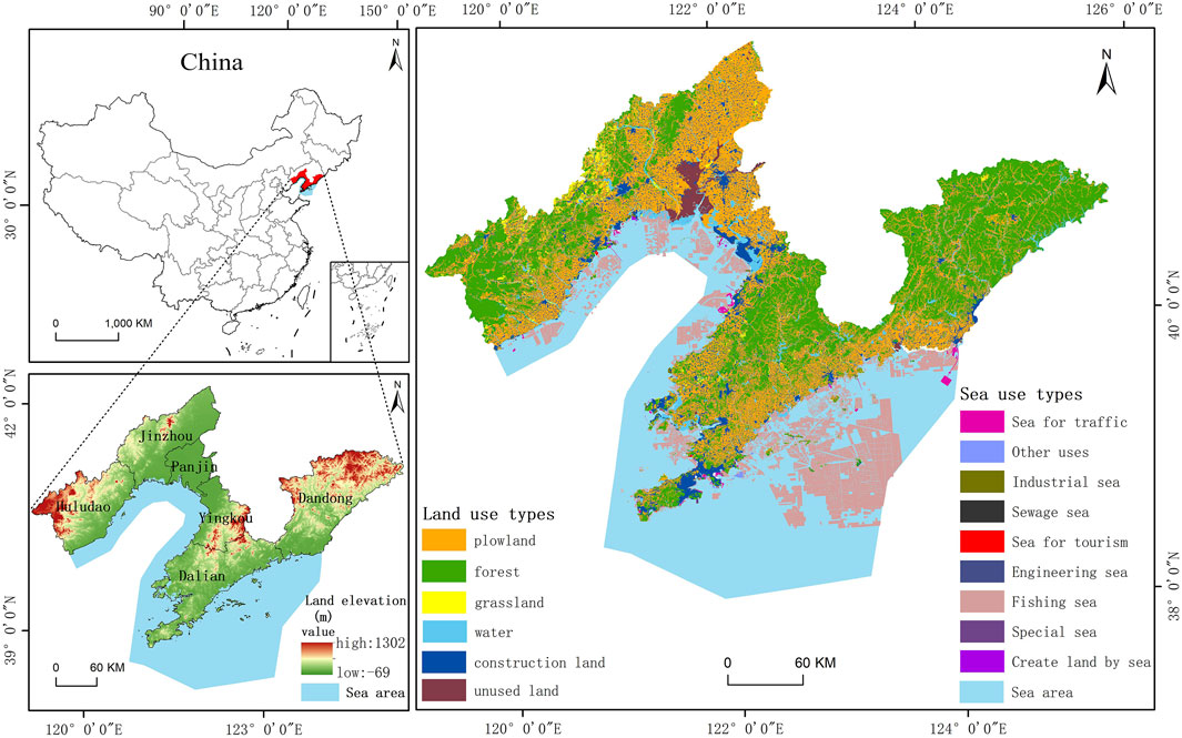
Figure 1. Location map of the study area and the use status of land-sea in 2020.
2.2 Data sources
The data used in this study mainly include geospatial data, ecological environment data and socio-economic statistics data. Specific data included: (1) Remote sensing monitoring data of land use from 2005 to 2020 (spatial resolution: 30 m) and regional data were obtained from Data Center for Resources and Environmental Sciences and Chinese Academy of Sciences (http://www.resdc.cn/); (2) The data of Liaoning Province’s sea use right confirmation and sea scope from 2005 to 2020 are from Liaoning Provincial Department of Natural Resources. The sea use right confirmation data identify the types of sea by determining which marine areas have been allocated for specific uses; (3) The soil organic matter data set in China is derived from A Big Earth Data Platform for Three Poles (https://poles.tpdc.ac.cn/zh-hans/), terrestrial NPP (MOD17A3HGF) data from the national aeronautics and space administration (https://www.earthdata.nasa.gov/), marine NPP data from global change science research data publishing system (https://www.geodoi.ac.cn/); (4) Data on the output, price and cost of food, energy and raw materials are obtained from China Fishery Statistical Yearbook, China Energy Statistical Yearbook, Compilation of Cost and Income Data of National Agricultural Products, Liaoning Provincial Statistical Yearbook and other available yearbook data and government work reports for 2006–2021. Other data comes from web searches and related research projects.
3 Methods
By analysing the theoretical connotation of related research, this paper takes the space use status and bio-economic environmental data of land and sea as the data basis. Secondly, this paper constructs PLEF value measurement system from the main functions of land and sea space. Then, this paper establishes the identification rules according to PLEF value measure, so as to delineate PLES combination patterns of the study area, and analyses its spatio-temporal evolution with the help of land use transfer matrix, center of gravity transfer and standard deviation ellipse model. Finally, this paper discusses the interaction mechanism of human activities and material exchange in coastal zone PLES under the perspective of land-sea coordination, so as to provide a scientific theoretical basis for the future direction of spatial optimisation in the coastal zone (Figure 2).
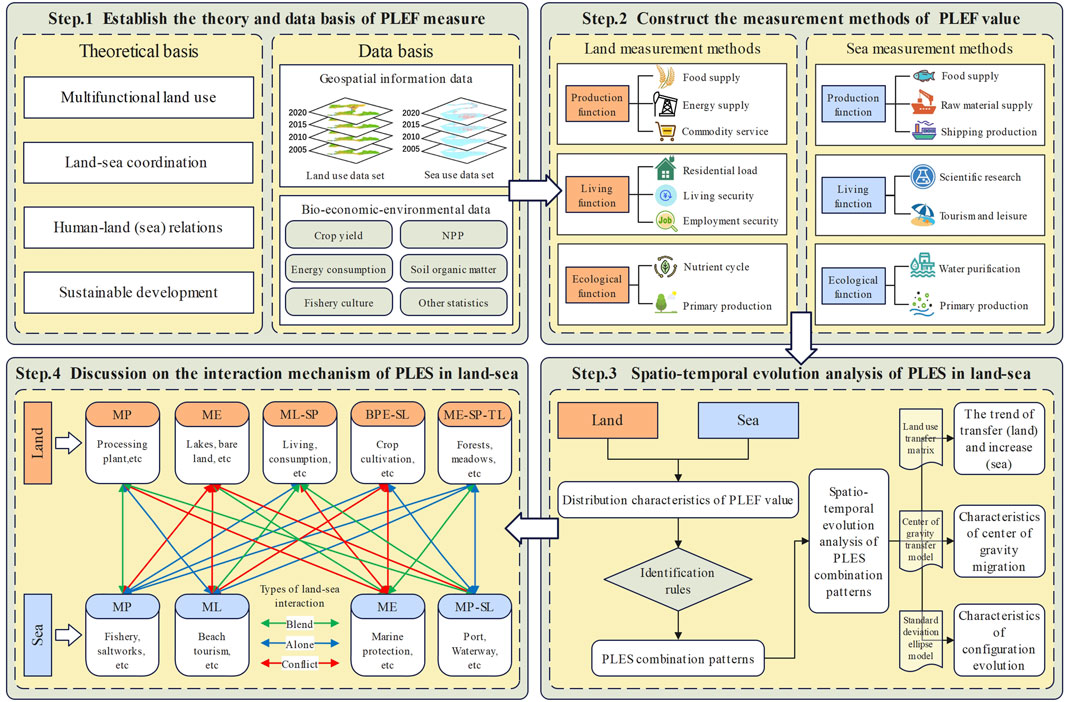
Figure 2. Research frame diagram.
3.1 The PLEF measurement methods based on land - sea coordination
The multi-functionality of territorial space and the complex relationship between man and land determine that the measurement of PLES needs to be valued from the perspectives of economy, society and environment (Duan et al., 2023; Zou et al., 2021; Lin et al., 2022). At present, PLES multifunctional value evaluation usually includes two aspects: biophysical process calculation and functional value transformation. The former is relatively accurate but has strong data dependence, while the latter has strong applicability but poor accuracy and spatial heterogeneity (Li and Fang, 2016; Ji et al., 2020). In this paper, the two methods were comprehensively applied and supplemented by the complementary measurement results of ecosystem service value equivalent established by Xie et al. (2015), to construct the PLEF value measurement evaluation system, and then identify the complex functional characteristics of PLES in the study area.
Production functions include the functions of various products and services obtained through direct or indirect social production activities based on land or sea (Li and Fang, 2016; Hu et al., 2017). In this study, the land production function is measured by the three indexes of food or raw material supply, energy supply and production of goods and services based on the main material output and inherent value required for human survival and development. The production function of the sea is selected by the value of fisheries, industrial products and transportation services obtained by humans through the sea, and measured by four indicators: food production, salt industry resources, offshore oil and gas resources, and port and waterway transportation resources. The specific methods are shown in Table 1.
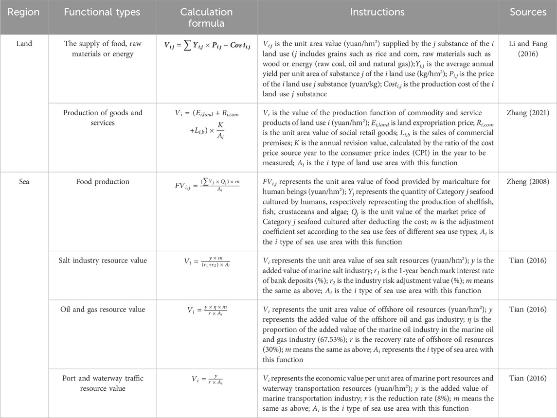
Table 1. Measurement methods of production function.
Living functions include all kinds of space bearing, material and spiritual guarantee functions provided by land or sea for human beings (Li and Fang, 2016). This paper selects the measurement index from the perspective of security and cultural entertainment. The land is measured by three indicators: residential support, basic living security and employment security, while the sea is measured by scientific research and cultural value and tourism and entertainment value. The specific methods are shown in Table 2.
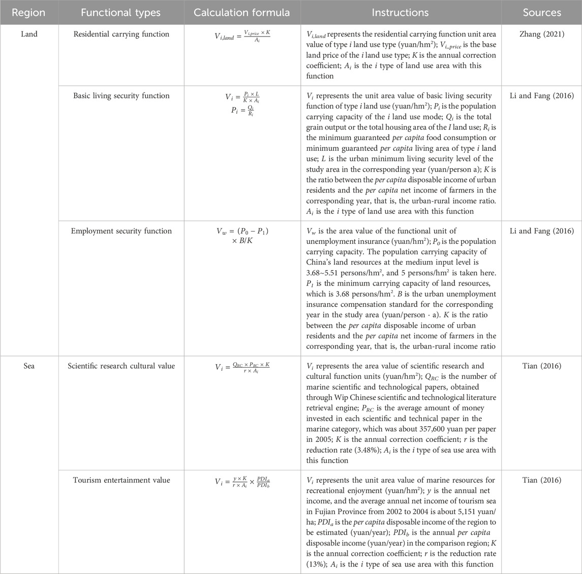
Table 2. Measurement methods of living function.
Ecological functions include regulating and circulating functions for maintaining the stability of the living environment and the balance of the ecosystem (Duan et al., 2023). In this study, the land was evaluated according to the main ecological factors such as soil and vegetation, and the nutrient cycle and primary production index system were used to measure the land. Water purification, carbon sequestration and oxygen release are used to measure the ecological effects of plankton in the sea. The specific methods are shown in Table 3.
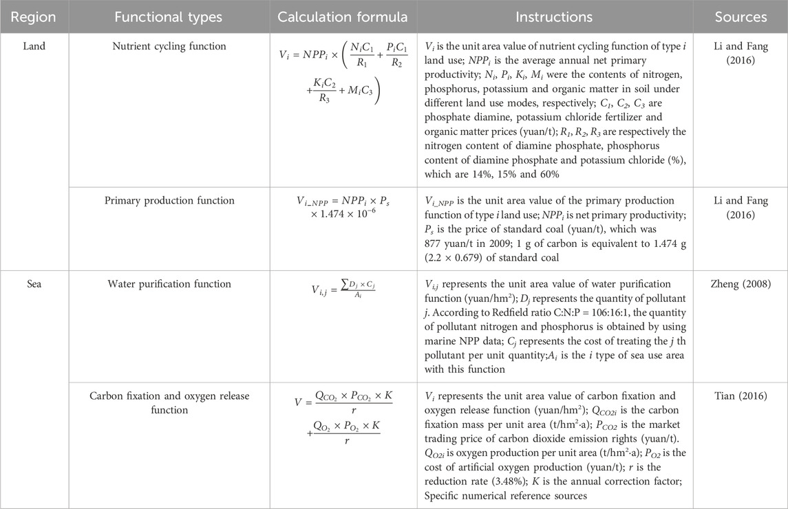
Table 3. Measurement methods of ecological function.
3.2 Land use transfer matrix
The land use transfer matrix can reflect the dynamic process information of the mutual transformation between different spatial types in a certain period of time in the study area (Qiao et al., 2013). In this paper, the model is used to analyze the long-term dynamic evolution characteristics of PLES multi-functional combination patterns, in order to explore the whole transfer process of land use functional space. Its common form (Equation 1) is:
In the formula, Sij is the combination pattern area from the initial i-type to the later j-type, and n is the number of PLES combination patterns.
3.3 Center of gravity transfer model
The center of gravity transfer model reflects the distribution pattern and change trend of regional land function space to a certain extent through the change of center of gravity position and migration direction of each PLES type (Equations 2, 3). The formula is as follows:
In the formula, Xt and Yt represent the longitude and latitude coordinates of the center of gravity of a certain PLES in the t year; Cti represents the area of the PLES of the i region; Xi and Yi respectively represent the latitude and longitude coordinates of the geometric center of the i th region. D represents the distance between the center of gravity of the PLES in different periods. E is a constant, where the geographical coordinates are converted to the value corresponding to the plane distance, taking 111.111 km.
3.4 Standard deviation ellipse model
The standard deviation ellipse method is one of the classical methods to analyze the directivity of spatial distribution, which can describe the outline and dominant direction of the spatial distribution of the analysis object, and quantitatively explain the overall characteristics of the analysis elements such as centrality (Equation 4), distribution, directivity and spatial form from a global perspective. The relative position, main trend and spatial form of the combined mode spatial transfer of the functional space in the study area can be quantitatively described by the azimuth of the standard deviation ellipse (Equation 5), the standard deviation of the short axis and the standard difference of the long axis (Equations 6, 7). The formula (Zhao and Zhao, 2014) is:
Mean center:
Azimuth:
X-axis standard deviation:
Y-axis standard deviation:
In the formula, (xi, yi) represents the spatial location of the research object, wi represents the weight; θ is the elliptical azimuth, representing the angle formed by clockwise rotation from the true north direction to the major axis of the ellipse;
4 Results
4.1 General characteristics
4.1.1 Distribution characteristics of PLEF value based on land-sea coordination
Based on the PLEF measurement index system, this study calculated the unit area value of land and sea space utilization in the Liaoning Coastal Economic Belt. Spatial visualization analysis of the PLEF value of the land and sea in the study area from 2005 to 2020 was carried out using the ArcGIS platform (Figure 3).
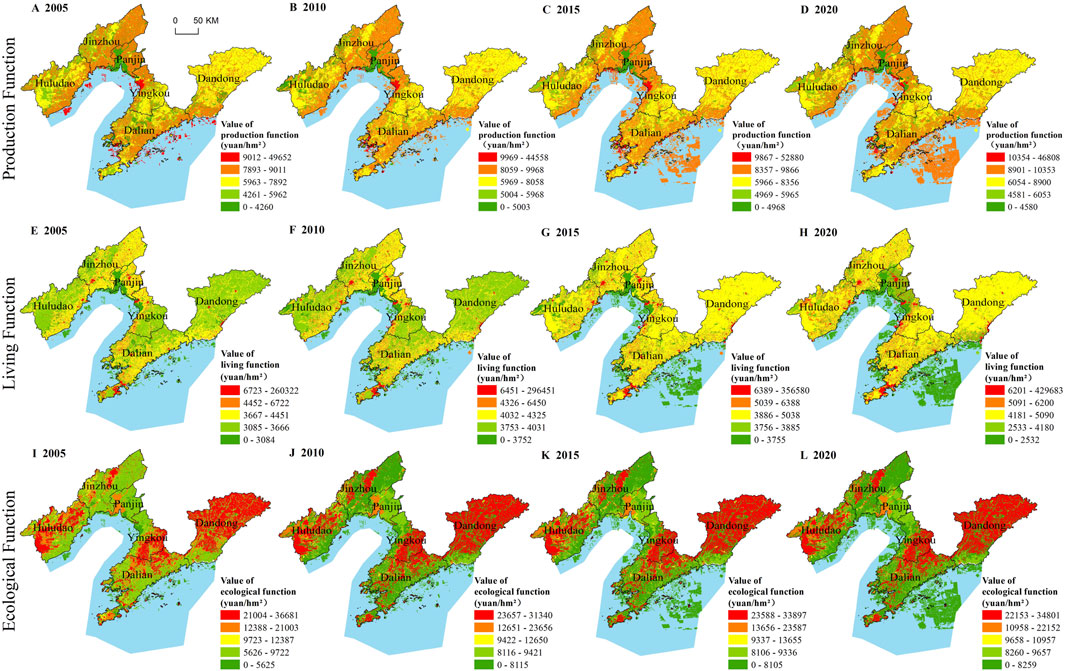
Figure 3. Distribution of production (A–D), living (E–H) and ecological (I–L) functions value in the study area (2005–2020).
In terms of the distribution of production function value, on land, high-value areas are mainly concentrated in the coastal areas of each city in the study area and north of the Liao River estuary. From an industrial perspective, the high-value concentration points are highly consistent with the distribution of coastal industrial parks. Additionally, the area north of the Liao River estuary has flat terrain and fertile soil, making it an important grain production base, which aligns with the characteristics of high production function; low-value areas are mainly distributed in the western part of Huludao City and Jinzhou City, the Liao River estuary area of Panjin City, the eastern part of Yingkou City, and the north of Dandong City. Analyzing from the perspective of terrain and human activities, these areas, except for the Liao River estuary, are rugged with few human activities, hence the relatively weak production function. The overall production function value of the sea is relatively high, with the deep sea being more significant, and only scattered point-like sea use types near the shore have lower production value. The high-value area of land production function corresponds significantly with arable land and other construction land, while the high-value area of sea production function mostly overlaps with fisheries, industry, and transportation sea use types. This measurement result is consistent with the actual situation, indicating that the spatial function value measurement method constructed in this paper can objectively reflect the strength of various spatial value functions.
Regarding the distribution of the value of living function, on land, high-value areas are generally characterized by a scattered point distribution, with distinct aggregations of high values observed in areas close to the coast and water sources, and in regions with relatively flat terrain; low-value areas are located in the western parts of Huludao City and Jinzhou City, the Liaohe River estuary area of Panjin City, the southeastern part of Yingkou City, and the northern part of Dandong City. The common features of these regions are that they are mostly rugged mountain forest zones with a low degree of development. In terms of the sea, high-value areas are distributed in a point pattern along the nearshore zones, with lower values in the offshore areas. The high-value areas of the living function on land show a significant correlation with urban and rural residential land uses, while the high-value areas of the living function in the maritime areas are often associated with areas used for tourism and entertainment. The value of living functions is inextricably linked to human activities, and the measurement results objectively reflect the current perception.
Looking at the distribution of the value of ecological function, in terms of the land, high-value areas are primarily located in the western part of Huludao City, the central part of Yingkou City, and the northeastern part of Dandong City, corresponding to the low-value areas of the living function; low-value areas are mainly found in coastal zones with flat terrain and frequent human activities, corresponding to the high-value areas of the production function. The overall ecological function value in the maritime areas is relatively low, with sparse and small-proportion high-value areas. Regarding land, high-value areas correspond mainly to ribbon-like areas related to forests, grasslands, and waters, while in the sea, high-value areas are primarily types of sea use that play a role in marine protection, reflecting that the measurement results are generally reasonable.
4.1.2 Distribution characteristics of PLES combination patterns
This paper refers to the division method of existing studies (Li and Fang, 2016; Ji et al., 2023)to construct PLEF value identification rules (Figure 4). According to the single function, double functions, and triple functions of the PLES, seven combination patterns are ultimately identified in the study area: Main Production (MP) space, Main Living (ML) space, Main Ecological (ME) space, Main Production - Secondary Living (MP-SL) space, Main Living - Secondary Production (ML-SP) space, Balanced Production and Ecological - Secondary Living (BPE-SL) space, and Main Ecological - Secondary Production–Tertiary Living (ME-SP-TL) space.
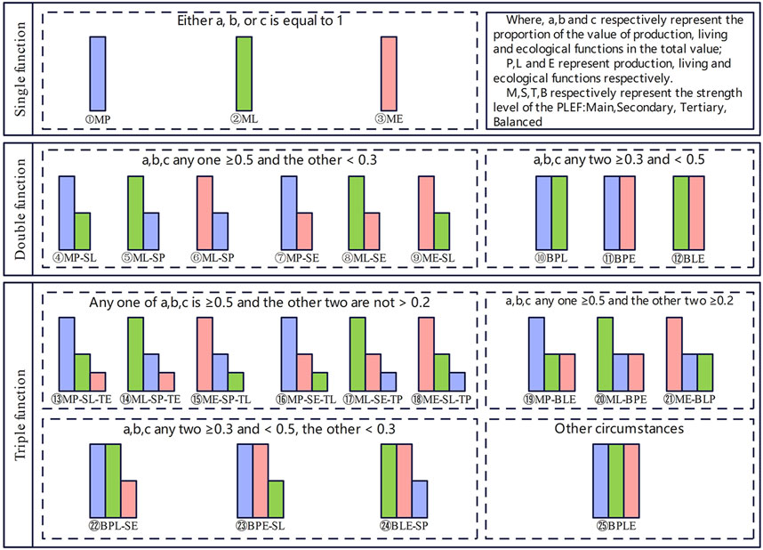
Figure 4. Identification rules of PLES based on functional value.
Analyzing the distribution (Figure 5) and proportion (Table 4) of PLES combination patterns, the land is mainly dominated by BPE-SL space and ME-SP-TL space, accounting for more than 40% during the research period. Among them, in 2005, the proportions were the highest, at 42.38% and 45.72% respectively. Other combination patterns are widely distributed, showing a scattered point-like distribution characteristic. ML-SP space shows a “local aggregation, overall dispersion” distribution characteristic, and the proportion has been increasing from 5.91% to 8.26% during the research period, indicating that the space primarily used for living, by encroaching on other land types, is gradually expanding. The production value of the sea is considerable, and the MP space constitutes over 90%, while the remaining combination patterns are mostly distributed in the nearshore zone, primarily the transportation and entertainment sea where human-sea interaction is more frequent and intense. Additionally, the proportion of the ME space in the sea has been decreasing year on year, ranging from 2.53% to 0.39%. The phenomenon is primarily due to the rapid expansion in MP space and the simultaneous slowdown in the development of marine protection and other maritime uses.
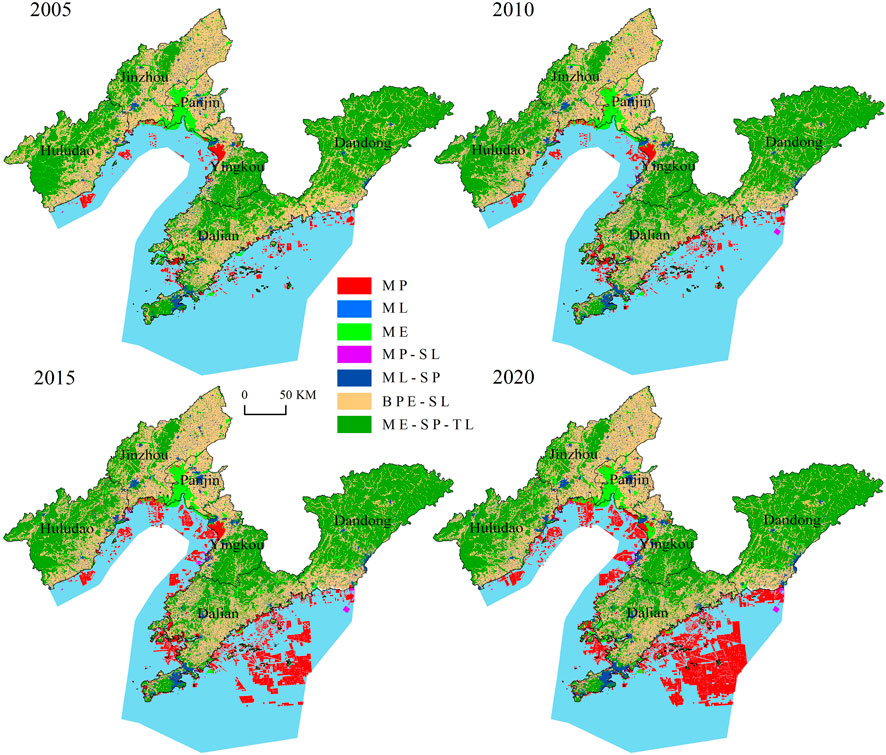
Figure 5. Distribution of PLES combination patterns in the study area (2005–2020).

Table 4. Composition proportion of combination patterns of PLES from 2005 to 2020.
From the perspective of the multifunctionality of land and sea use, most land areas possess dual or triple functions, with a very pronounced multifunctionality. This multifunctionality indicates a high comprehensive utilization rate of land, which helps to alleviate the landscape imbalance caused by single-function use, but it may also lead to conflicts and contradictions in land use (Li and Fang, 2016). Therefore, it is necessary to identify the multifunctionality of land use, analyze the evolutionary patterns, and make comprehensive trade-offs in combination with actual conditions to eliminate the negative impacts between different types of land use. The PLEF of the sea is relatively singular, especially in the deep sea, where the focus is primarily on production space. Therefore, future efforts should concentrate on the comprehensive utilization of marine resources and the creation of a more diversified maritime spatial value system.
4.2 Spatiotemporal evolution analysis of PLES combination patterns
4.2.1 Transfer analysis of PLES combination patterns
This study utilizes land-sea spatial use data to analyze the transfer changes of PLES combination patterns in the Liaoning Coastal Economic Belt from 2005 to 2020, to explore the change amount and transfer direction between each pattern.
As shown in Figure 6, from a holistic perspective, the transfer amount between each pattern on land during 2005–2010 is the largest, indicating that the frequency of interaction among various land types was very high during this period. Specifically, during the research period, the transfer amounts for the BPE-SL and ME-SP-TL patterns were the greatest, and they transferred the most to each other, but the total amounts decreased gradually, reducing by 1,126 km2 and 506 km2 respectively. Secondly, the ML-SP space saw the largest increase, mainly transferred from the above two patterns, with an increase of 1,318 km2 over 15 years, and the growth rate has the characteristics of “high-low-medium”, followed by the MP space, with an increase of 204 km2. The ME space exhibited a “decrease-stability-increase” characteristic, with an overall increase of 110 km2. This indicates that the rapidly expanding living space has been effectively curbed, and the ecological construction has achieved remarkable results.
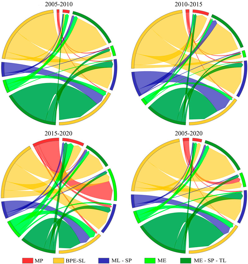
Figure 6. Transfer and change map of PLES combination patterns in land (2005–2020).
Due to the limitation of the sea use right confirmation data, there is no mutual transformation of the marine functional space, and only the unused sea is continuously transformed into the sea for production, living and ecological use, so only the increasing trend of the marine functional space is analyzed here. During the research period, the proportion of the sea MP space has been on the rise, increasing from 87.61% during 2005–2010 to 98.87% during 2015–2020. Especially between 2010 and 2015, the area increased sharply, indicating a focus on developing marine space primarily for production during this period. From 2015 to 2020, due to the saturation of sea functional zone development and other factors, the increase in new areas began to slow down, and except for the MP space, the growth proportion and area of other combination patterns all showed a continuous downward trend. It can be seen that the composite function of the PLES in the sea of the Liaoning Coastal Economic Belt is relatively single, and the proportion is not balanced, to adapt to the coordinated and sustainable development trend of PLEF and the marine economy, the proportion of marine living and ecological spaces should be increased, such as coastal tourism, seawater comprehensive utilization industry, and social service industry.
4.2.2 Evolution analysis of land-sea PLES combination patterns
Using the center of gravity transfer and standard deviation ellipse model, and utilizing the ArcGIS software platform to display the distribution of the PLES center of gravity in the Liaoning Coastal Economic Belt and to analyze the direction and state of spatial transfer of PLES along the time sequence from 2005 to 2020 (Figures 7–9).
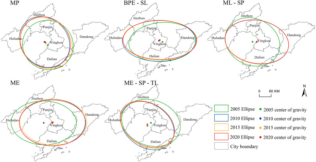
Figure 7. Ellipse analysis chart of standard deviation of PLES combination patterns in land (2005–2020).
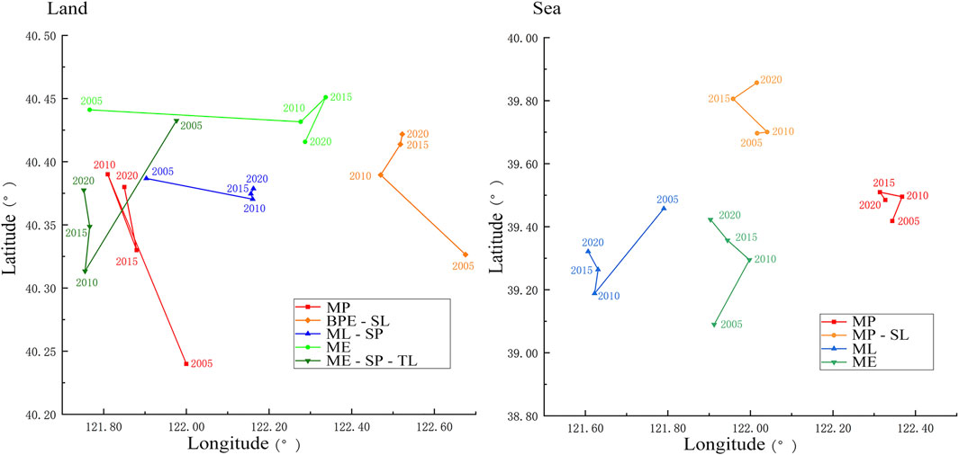
Figure 8. Center of gravity transfer chart of PLES combination patterns in land-sea (2005–2020).
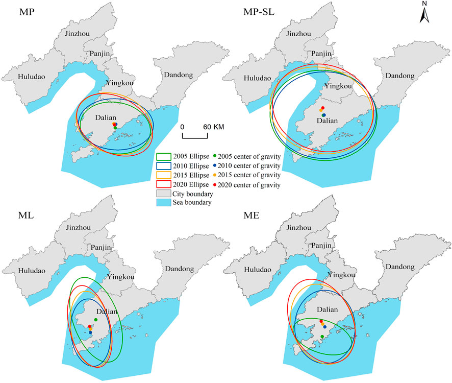
Figure 9. Ellipse analysis chart of standard deviation of PLES combination patterns in sea (2005–2020).
Overall, the centroids of various PLES combination patterns in the land and sea of the Liaoning Coastal Economic Belt migrated the most, and the positions and sizes of the ellipses were significantly different compared to other stages during 2005–2010, indicating that the PLES in the study area underwent drastic changes during this period. On the other hand, PLES combination patterns in the sea have a greater magnitude of elliptical shape change compared to the land at different time points from 2005 to 2020, indicating that the various patterns in the sea are relatively more variable than those on land, and the overall performance is more stable on land.
Specifically, the center of gravity of MP space gradually shrank in migration distance, and the elliptical layout runs from Dalian City in the southeast to Jinzhou City in the northwest, covering region increased first and then decreased, mainly distributed in the center of the study area near the coast. It indicates that the regional development speed of MP space was inconsistent but is gradually aggregating towards areas with dense population and flat terrain, thus tending to stabilize. BPE-TL space saw the centroid migration distance first increase and then decrease, with the ellipse distribution being approximately east-west oriented. The X-axis and rotation angle increased the most during 2005–2010 and continued to rise year by year, indicating that the spatial evolution of this pattern during the research period gradually intensified, mainly expanding towards the northwestern cities of Huludao and Jinzhou. MP-SL space had a rotation angle of the ellipse in 2005 that differed by about 20° from other years, and the centroid migration distance was relatively long, and the ellipse area increased significantly during 2005–2010, and then basically remained unchanged, indicating that this pattern first expanded sharply to the northeast and then stabilized. ME space saw a clear eastward shift in the centroid during 2005–2010, and the ellipse area increased, and basically remained unchanged in other years, indicating that this pattern evolved eastward and then remained relatively stable. ME-SP-TL space had an ellipse layout in a southeast-northwest direction, and the centroid migration trajectory was approximately the opposite of ML-SL space, but the centroid gradually stabilized at the same latitude, indicating that the living space and ecological space experienced a process of conflict and coordinated development, and overall tend to develop in a multifunctional coordinated manner.
In the sea, the center of gravity for the MP space initially shifted northeastward along the coast of the Yellow Sea, then moved westward towards the Bohai Sea, and finally progressed towards the southeast direction of the Yellow Sea. The elliptical layout was predominantly oriented from southeast to northwest, with Dalian City as the central point, alternating development between the Bohai Sea and Yellow Sea sides throughout the study period. MP-SL space’s center of gravity generally moved northward, with an elliptical configuration approximately running east to west, covering a broad area and expanding along the northwestern edge of the Bohai Sea, suggesting a dispersed pattern with a strong reliance on the coastline, mainly developing along the Bohai Bay axis. The migration path of ML space’s center of gravity and its elliptical area closely resembled that of the ME-SP-TL space on land, with the elliptical area first decreasing sharply, then expanding towards the northwestern Bohai Sea direction, indicating a relationship with the ecologically dominant composite functional land use on land and a development orientation towards the vicinity of the Bohai Bay. The migration of the ME space’s center of gravity and its elliptical changes showed a “conflict before coordination” characteristic with the ML space, suggesting a growing emphasis on the synergistic development of living and ecological spaces in maritime planning.
5 Discussion
This paper constructs a PLEF value measurement method to achieve the measurement and spatial classification of the PLEF in the Liaoning Coastal Economic Belt, analyzing the distribution pattern of PLES and the spatiotemporal evolution, current characteristics, and development trends of the composite function spaces, which are of significant guidance and practical application value for the coordinated planning of coastal zone.
5.1 Discussion on the PLEF measurement system
This paper builds a comprehensive coastal PLEF measurement system from a multidisciplinary perspective and the main functional characteristics of territorial space. It provides a clear research path for the functional measurement and evolution law exploration of coastal space. However, due to the complexity of land use and the limitations of research data, all possible function values are not fully considered. Additionally, some indicators lack specific unified values. Although a combination of qualitative and quantitative methods is used for comprehensive evaluation, it is difficult to ensure absolute accuracy in numerical values due to different measurements and focus points. Finally, this paper only studies the confirmed sea but does not consider the PLEF generated by non-confirmed sea, which will have a certain impact on the actual results. Therefore, it is recommended that future studies use multiple means such as satellite remote sensing, drone monitoring, and on-site surveys, incorporating indicators such as the full life cycle cost and ecosystem diversity to enrich the evaluation content and improve the accuracy of the evaluation, comprehensively reflecting the functional characteristics of the PLES.
5.2 Differentiated response of PLES evolution
This study conducted a detailed analysis of the functional measurement and spatiotemporal evolution characteristics of the PLES in the Liaoning Coastal Economic Belt from 2005 to 2020. However, the driving factors behind the evolution phenomenon and the differentiated response mechanisms between regions still need further research. Therefore, future studies should systematically explore the key driving forces affecting the changes in the PLES pattern from multiple perspectives, including but not limited to the impact of regional policy formulation and implementation, the dynamic changes in the level of economic and social development, the structural changes in population migration activities, and the reshaping effect of technological innovation on spatial structure. A deep analysis of these driving factors will reveal the essence of the evolution of the PLES structure, providing more solid theoretical support for formulating scientific regional planning strategies.
At the same time, although the current study has initially revealed the overall functional configuration and evolution laws of the PLES in the study area, the regional differences have not been fully discussed. There are differences in resource endowment, industrial structure, population structure, and scale between different cities. Therefore, it is necessary to study in depth the specific response mechanisms of different cities in their PLES evolution process and how these mechanisms interact with each other, affecting the spatial structure evolution of the entire coastal zone. For example, by comparing and analyzing the similarities and differences in the PLES structure evolution of Dalian City, Yingkou City, Dandong City, and other places, the spatial structure change laws caused by socio-economic factors and ecological constraints in each region can be revealed, thereby enriching the understanding of the differentiated response mechanisms of PLES in regions, providing a more rigorous and refined scientific basis and practical guidance for optimizing the coastal zone spatial layout based on the land-sea coordination concept, and achieving the sustainable development strategy.
5.3 The interaction mechanism of coastal zone PLES under the perspective of land-sea coordination
The coastal zone has a high population density and a high degree of urbanization, with prominent resource environmental issues such as disorderly development and spatial structure imbalance (Yin et al., 2017). The concept of land-sea coordinated PLES has laid the foundation for promoting the construction of coastal ecological civilization with sustainable development as the direction (Pittman and Armitage, 2016; Schlüter et al., 2020; Ye et al., 2021). This study shows that the Liaoning Coastal Economic Belt has a high degree of functional complexity in the land, the PLES accounts for a relatively reasonable proportion and is gradually tending to be coordinated and stable development. The complexity of PLEF in the sea is relatively low, the evolution law of the PLES is not obvious as a whole, and the development direction is relatively disorderly. Therefore, the regional area needs to strengthen the overall grasp of the PLES pattern in the future, clarify the interactive mechanism between the land-sea various functional spaces (Figure 10), and coordinate the internal structure and external connections of each main space of the land and sea. Specifically, looking at the interactive effect of the production-leading space, it should improve the exchange efficiency of material products between the land and sea production space. For example, for the sea product processing plants on the land and the aquaculture space in the sea, short-distance transportation routes are opened to form a low-cost, high-efficiency industrial pattern of land-sea production space; Looking at the interactive effect of the living-leading space, it should develop the land and sea living space nearby, and build a convenient channel for living and entertainment. For example, the living and consumption space of the land town and the entertainment and leisure space of the sea are connected through the tourist route, thus creating a high-efficiency living space for the land-sea economic integration; Looking at the interactive effect of the ecology-leading space, it should be based on the actual situation of the land and sea, and consider the layout of the production and living space at the same time, forming a network of mountains, waters, and forests, and developing harmoniously. For example, ensure that the natural ecological protected areas of the land and sea are not destroyed, maintain the material exchange of large-scale ecological elements of the land and sea, and achieve a coordinated protection pattern of the land-sea ecological space. At the same time, it is also necessary to create local ecological spaces close to the production and living spaces and establish ecological corridors of the land and sea to connect the overall ecological network with local nodes, playing an overall ecological effect. Therefore, in addition to the internal interaction of the PLES, it is also necessary to consider the interactive mechanisms between different functional spaces. Based on the clear understanding of the interaction between different functional spaces of the land and sea, combined with the actual basis of the natural environment and economic policies, determine the development direction of the interactive space of the land and sea comprehensively, so as to fully strengthen the land-sea coordination, and form a land-sea space pattern with efficient production, livable living, and beautiful ecology.
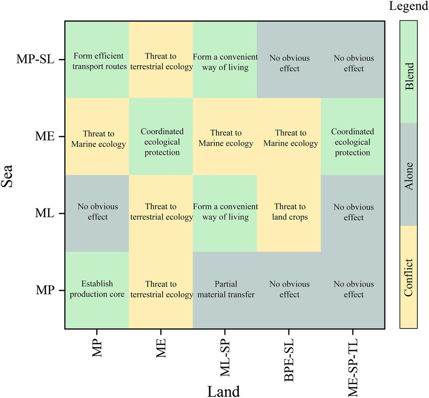
Figure 10. The interaction mechanism of PLES under the perspective of land-sea coordination.
6 Conclusion
This paper is based on the land and sea space utilization type, using a combination of qualitative and quantitative methods to achieve the identification and division of the PLES and its multifunctional combination patterns. Through the analysis of the transfer and trend of the types of land and sea space from 2005 to 2020, the paper clarifies the evolution characteristics of national territory space in Liaoning Coastal Economic Belt and analyzes the PLES evolution mechanism of the land and sea. The main conclusions are as follows:
(1) The high-value areas of terrestrial production and living spaces are distributed in a strip-like pattern and are concentrated near the coastline. The ecological space complements the other two spaces, mainly concentrated in the mountainous and forested areas of Huludao City in the west, Yingkou City in the center, and Dandong City in the northeast. The sea is dominated by production space, especially in the deep sea, which has increased significantly during the research period, while the living and ecological spaces account for a smaller proportion and are distributed in the nearshore areas.
(2) The multifunctionality of land use in the terrestrial area is obvious, with BPE-SL and ME-SP-TL spaces accounting for more than 40% of the total during the research period. MP and MP-SL spaces are mainly distributed in the coastal zone, showing a “generally dispersed, locally aggregated” characteristic, with ME space mainly being water systems, bare land, and other natural environments with less human intervention, with the most prominent distribution in the Liao River Basin. The PLEF of the sea is relatively single, mainly dominated by production function, accounting for more than 90%.
(3) Overall, from 2005 to 2010, the frequency of mutual transformation among various land types was the highest. The ML-SP space in the land is the type with the largest increase, with an increase of 1,318 km2 over the research period, and the growth rate has the characteristics of “high-low-medium”, indicating that the rapidly expanding living space has been effectively curbed. The sea is mainly characterized by a large increase in MP space, and future planning should aim for PLES coordination and consider and develop the types of sea utilization rationally.
(4) From 2005 to 2010, both land and sea PLES patterns showed significant changes, with the coastal zone functional space expanding sharply. Between 2010 and 2020, the center of gravity migrates a small distance, and the direction of the ellipse remained basically unchanged, mainly showing an increase or decrease in scope, and the development was relatively stable. The ecological and living spaces of the land and sea overall showed a pattern of “conflict first and then cooperation” indicating that the construction of ecological civilization has achieved significant results. The various patterns in the sea changed relatively more than those on land, and the proportion of production functions was too high. Future planning should coordinate the types of land and sea use on both sides of the coast, and increase the development and layout of living and ecological spaces.
Data availability statement
The original contributions presented in the study are included in the article/supplementary material, further inquiries can be directed to the corresponding author.
Author contributions
LK: Conceptualization, Formal Analysis, Funding acquisition, Methodology, Writing–original draft. LW: Data curation, Methodology, Software, Writing–original draft, Visualization. QW: Data curation, Investigation, Project administration, Supervision, Writing–review and editing. ZR: Investigation, Software, Supervision, Writing–review and editing. YaL: Investigation, Validation, Writing–review and editing. SY: Investigation, Validation, Writing–review and editing. YZ: Investigation, Validation, Writing–review and editing. QT: Visualization, Writing–review and editing, Software. YiL: Data curation, Software, Writing–review and editing.
Funding
The author(s) declare that financial support was received for the research, authorship, and/or publication of this article. This research was funded by the National Natural Science Foundation of China (No. 42076222, No. 42276231, No. 42201070), Sub-project of National Key Research and Development Program of China (No. 2022YFC3106101), Natural Science Foundation of Liaoning Province, China (No. 2021-MS-247) and the Social Science Federation Project of Liaoning Province (No. 2024lslybkt-038).
Acknowledgments
We would like to express our sincere gratitude to the editor and referees for their insightful and constructive comments.
Conflict of interest
The authors declare that the research was conducted in the absence of any commercial or financial relationships that could be construed as a potential conflict of interest.
Generative AI statement
The authors declare that no Generative AI was used in the creation of this manuscript.
Publisher’s note
All claims expressed in this article are solely those of the authors and do not necessarily represent those of their affiliated organizations, or those of the publisher, the editors and the reviewers. Any product that may be evaluated in this article, or claim that may be made by its manufacturer, is not guaranteed or endorsed by the publisher.
Abbreviations
PLES, Production-Living-Ecological Spaces; PLEF, Production-Living-Ecological Functions; MP, Main Production; ML, Main Living; ME, Main Ecological; MP-SL, Main Production-Secondary Living; ML-SP, Main Living-Secondary Production; BPE-SL, Balanced Production and Ecological-Secondary Living; ME-SP-TL, Main Ecological-Secondary Production-Tertiary Living.
References
Cai, Y., Gao, Y., Zhang, J., and He, T. (2017). Evolution and illumination of American spatial planning system. Planners 33, 28–34. Available at: https://kns.cnki.net/kcms2/article/abstract?v=KrjhrmY9aOUIqFj_C3z88dUkaRSDsX18_EUa8_4dIfcKK4DR_iYJZAX4ORpYU4AQsQWP5p2jsoQjwWX1Zdk-37F2WiUPYhIuAhYWYwsfiro8wvJsbwNQ_6Q4-NOoEroKee393H1lZPIKnk6kppO2HGf30cHz_abPylUZS-x-OVbNxDq_Yymtav-YD_WFCRCpU3hLx6n7CYY=&uniplatform=NZKPT&language=CHS
Chen, X., Di, Q., and Wu, H. (2023). Measurement and evaluation of the economic high-quality development level of the Liaoning coastal economic belt. Resour. Dev. and Mark. 39, 1022–1029. doi:10.3969/j.issn.1005-8141.2023.08.011
Cheng, Y., Li, Y., and Zhao, M. (2019). Experience and lessons of EU marine spatial planning: the perspective of land and sea territorial integration. Urban Plan. Forum, 59–67. doi:10.16361/j.upf.201905006
Di Ludovico, D., and D’Ascanio, F. (2019). European cross-scale spatial planning and territorial frames in the Italian Median Macroregion. Eur. Plan. Stud. 27, 1369–1390. doi:10.1080/09654313.2019.1581729
Duan, Y., Huang, A., Lu, L., Ji, Z., and Xu, Y. (2023). Analysis on concept and theories of “production living ecological” spaces. J. China Agric. Univ. 28, 170–182. doi:10.11841/i.issn.1007-4333.2023.04.16
Duan, Y., Wang, H., Huang, A., Xu, Y., Lu, L., and Ji, Z. (2021). Identification and spatial-temporal evolution of rural “production-living-ecological” space from the perspective of villagers’ behavior – a case study of Ertai Town, Zhangjiakou City. Land Use Policy 106, 105457. doi:10.1016/j.landusepol.2021.105457
Frankhauser, P., Tannier, C., Vuidel, G., and Houot, H. (2018). An integrated multifractal modelling to urban and regional planning. Comput. Environ. Urban Syst. 67, 132–146. doi:10.1016/j.compenvurbsys.2017.09.011
Fu, J., Gao, Q., Jiang, D., and Lin, G. (2022). Optimal regulation of spatial planning in the context of black soil preservation and food security in Qiqihar. Acta Geogr. Sin. 77, 1662–1680. doi:10.11821/dlxb202207007
Gong, W., Zhang, H., and Zhong, X. (2015). Research on the development mode of coastal area basing on ecosystem of Sea-land interaction. Urban Dev. Stud. 22, 79–85. Available at: https://kns.cnki.net/kcms2/article/abstract?v=KrjhrmY9aOW8uJIAPWWhI9yFsZQFOFboG3InlNZ8Gi0qydNk7exgsmoixeuaALpzqxUopNpYPBIwmwbUhccgzl-9R9R49iQTDCqRcmS-7at3s4e6x7yeupNX1SffYLU2jlaVmx8O4BopDkKH77JiwhIWiW64rKFjWl2BUKVqP7F7ShOkBinO96qhjeS2U4eEdwYAAMQsh6k=&uniplatform=NZKPT&language=CHS
Hu, H., Xu, W., Yue, Q., Zhang, P., and Liu, L. (2017). Exploration on mode of coastal zoning based on ecological-living-industrial spaces: a case study of Tangshan city. Areal Res. Dev. 36, 29–33. Available at: https://kns.cnki.net/kcms2/article/abstract?v=KrjhrmY9aOWtjFs5byEpIP_eukfBR0VfXG8mJwLGD9q3ZrHnGM4yxJ3vf_izAoPGouqtBgl130oOwinE_YQPpEELHKhz8JX2y-dRUBEEAxTQRT3YQBXShfi9_I-FX_z1mQ9NOQR2y9eTxrezBmLcHRymmmf7f13g-IIV0QPFQ-yCOjI1QSy94OXrk6cwPM_1bhMzIEW-xOo=&uniplatform=NZKPT&language=CHS
Huang, A., Xu, Y., Lu, L., Liu, C., Zhang, Y., Hao, J., et al. (2020). Research progress of the identification and optimization of production-living-ecological spaces. Prog. Geogr. 39, 503–518. doi:10.18306/dlkxjz.2020.03.014
Huang, J., Lin, H., Qi, X., Qi, L., Haoxi, L., and Xiaoxiao, Q. (2017). A literature review on optimization of spatial development pattern based on ecological-production-living space. Prog. Geogr. 36, 378–391. doi:10.18306/dlkxjz.2017.03.014
Ji, Z., Liu, C., Xu, Y., Huang, A., Lu, L., and Duan, Y. (2020). Identification and optimal regulation of the production-living-ecological space based on quantitative land use functions. Trans. Chin. Soc. Agric. Eng. 36, 222–231+315. doi:10.11975/j.issn.1002-6819.2020.18.027
Ji, Z., Liu, C., Xu, Y., Sun, M., Wei, H., Sun, D., et al. (2023). Quantitative identification and the evolution characteristics of production—living—ecological space in the mountainous area: from the perspective of multifunctional land. J. Geogr. Sci. 33, 779–800. doi:10.1007/s11442-023-2106-x
Jiang, X., Zhai, S., Liu, H., Chen, J., Zhu, Y., and Wang, Z. (2022). Multi-scenario simulation of production-living-ecological space and ecological effects based on shared socioeconomic pathways in Zhengzhou, China. Ecol. Indic. 137, 108750. doi:10.1016/j.ecolind.2022.108750
Kidd, S., Calado, H., Gee, K., Gilek, M., and Saunders, F. (2020). Marine Spatial Planning and sustainability: examining the roles of integration - scale, policies, stakeholders and knowledge. Ocean. Coast. Manage 191, 105182. doi:10.1016/j.ocecoaman.2020.105182
Kuang, W., Du, G., Lu, D., Dou, Y., Li, X., Zhang, S., et al. (2021). Global observation of urban expansion and land-cover dynamics using satellite big-data. Sci. Bull. 66, 297–300. doi:10.1016/j.scib.2020.10.022
Li, G., and Fang, C. (2016). Quantitative function identification and analysis of urban ecological-production-living spaces. Acta Geogr. Sin. 71, 49–65. doi:10.11821/dlxb201601004
Li, H., Fang, C., Xia, Y., Liu, Z., and Wang, W. (2022). Multi-Scenario simulation of production-living-ecological space in the Poyang lake area based on remote sensing and RF-Markov-FLUS model. Remote Sens. 14, 2830. doi:10.3390/rs14122830
Li, R., Li, Y., and Hu, H. (2020). Support of ecosystem services for spatial planning theories and practices. Acta Geogr. Sin. 75, 2417–2430. doi:10.11821/dlxb202011011
Li, Y., Liu, D., and Luo, T. (2021). The internal logic and developing direction of land-sea coordination in land space planning: from the perspective of complex system theory. Geogr. Res. 40, 1902–1916. doi:10.11821/dlyj020200397
Liao, G., He, P., Gao, X., Lin, Z., Huang, C., Zhou, W., et al. (2022). Land use optimization of rural production–living–ecological space at different scales based on the BP–ANN and CLUE–S models. Ecol. Indic. 137, 108710. doi:10.1016/j.ecolind.2022.108710
Lin, G., Jiang, D., Fu, J., and Zhao, Y. (2022). A review on the overall optimization of production–living–ecological space: theoretical basis and conceptual framework. Land 11, 345. doi:10.3390/land11030345
Liu, B., and Zhao, J. (2014). Research on the design of remote sensing classification system for sea areas. Ocean Dev. Manag. 31, 20–24. doi:10.20016/j.cnki.hykfygl.2014.06.006
Liu, H., and Qin, S. (2023). Working together with global eco-civilization construction: generating logic, core meaning and global significance. J. Northeast. Univ. Soc. Sci. 25, 131–137. doi:10.15936/j.cnki.1008-3758.2023.01.015
Liu, J., Liu, Y., and Li, Y. (2017). Classification evaluation and spatial-temporal analysis of “production-living-ecological” spaces in China. Acta Geogr. Sin. 72, 1290–1304. doi:10.11821/dlxb201707013
Pittman, J., and Armitage, D. (2016). Governance across the land-sea interface: a systematic review. Environ. Sci. Policy 64, 9–17. doi:10.1016/j.envsci.2016.05.022
Prévost, A., and Robert, S. (2016). Local spatial planning practices in four French Mediterranean coastal territories under pressure. Land Use Policy 56, 68–80. doi:10.1016/j.landusepol.2016.04.034
Qiao, W., Sheng, Y., Fang, B., and Wang, Y. (2013). Land use change information mining in highly urbanized area based on transfer matrix: a case study of Suzhou, Jiangsu Province. Geogr. Res. 32, 1497–1507. Available at: https://kns.cnki.net/kcms2/article/abstract?v=KrjhrmY9aOU5ESobHcoMeZkBc9oTsujCtgOwIJa271lSkDpHS1hsJZnuDcMwoTSb382x410nivxGGLEbmg138iCNheUXd1X2GlmTLaVOa6ddbcxQ1JZASMHIi7Cy9EAa126dwXp6QTdkNgJUtgew3qSMlnfpeSXtWnvoBvz05GYIBF1Cbh8AJwNbA4NFx7vN&uniplatform=NZKPT&language=CHS
Rivers, N., Truter, H. J., Strand, M., Jay, S., Portman, M., Lombard, A. T., et al. (2022). Shared visions for marine spatial planning: insights from Israel, South Africa, and the United Kingdom. Ocean. Coast. Manage 220, 106069. doi:10.1016/j.ocecoaman.2022.106069
Schlüter, A., Van Assche, K., Hornidge, A.-K., and Văidianu, N. (2020). Land-sea interactions and coastal development: an evolutionary governance perspective. Mar. Policy 112, 103801. doi:10.1016/j.marpol.2019.103801
Song, Y., Xue, D., Xia, S., and Mi, W. (2021). Change characteristics and formation mechanism of the territorial spatial pattern in the Yellow River Basin from 1980 to 2018, China. Geogr. Res. 40, 1445–1463. doi:10.11821/dlyj020191065
The State Council of the People’s Republic of China (2021). The state Council on high-quality development plan of liaoning coastal economic Belt. Gazette of the State Council of the People’s Republic of China. Available at: https://kns.cnki.net/kcms2/article/abstract?v=KrjhrmY9aOUyBDd-GuPJfiITLP_foRgG-5Nmx1nS2O1_x6F_1lXLU2gBLDxEx88KOSNsKXG1t7Sqrvn3f2h2EEDIUVBnJ4NWyUf5Ej2WhL_oBiMPLwCRHIoRXLmBj7cAsKnPIuSorvF5m7FBEtgxC4ImDSGRoxhs41XzaYGVAzPT1KlgACzr6r_mIWgSE_hzgbiKS6fBVsw=&uniplatform=NZKPT&language=CHS
Tian, P. (2016). Study on marine resources evaluation and application: a case of Tianjin. Hebei University. Available at: https://kns.cnki.net/kcms2/article/abstract?v=KrjhrmY9aOUyBDd-GuPJfiITLP_foRgG-5Nmx1nS2O1_x6F_1lXLU2gBLDxEx88KOSNsKXG1t7Sqrvn3f2h2EEDIUVBnJ4NWyUf5Ej2WhL_oBiMPLwCRHIoRXLmBj7cAsKnPIuSorvF5m7FBEtgxC4ImDSGRoxhs41XzaYGVAzPT1KlgACzr6r_mIWgSE_hzgbiKS6fBVsw=&uniplatform=NZKPT&language=CHS
Wang, C., and He, Z. (2024). Research on cohesion strategy of land-sea functional oriented zoning based on perspective of land-sea coordination. Bull. Chin. Acad. Sci. 39, 689–701. doi:10.16418/j.issn.1000-3045.20240329003
Wang, J. (2016). National spatial strategic plan of England. J. Urban Plann. Dev. 142, 04015007. doi:10.1061/(ASCE)UP.1943-5444.0000284
Wang, X., Ma, B., Li, D., Chen, K., and Yao, H. (2020). Multi-scenario simulation and prediction of ecological space in Hubei province based on FLUS model. J. Nat. Resour. 35, 230–242. doi:10.31497/zrzyxb.20200119
Xie, G., Zhang, C., Zhang, L., Chen, W., and Li, S. (2015). Improvement of the evaluation method for ecosystem service value based on per unit area. J. Nat. Resour. 30, 1243–1254. doi:10.11849/zrzyxb.2015.08.001
Yang, Q., Duan, X., Wang, L., and Jin, Z. (2018). Land use transformation based on ecological-production-living spaces and associated eco-environment effects: a case study in the yangtze river delta. Sci. Geogr. Sin. 38, 97–106. doi:10.13249/j.cnki.sgs.2018.01.011
Ye, G., Fei, J., Wang, Z., Jiang, Q., Gaines, S. D., and Ming, C. L. (2021). A novel marine spatial management tool for multiple conflicts recognition and optimization of marine functional zoning in the East China sea. J. Environ. Manag. 298, 113506. doi:10.1016/j.jenvman.2021.113506
Yin, P., Lin, L., Chen, B., Xiao, G., Cao, K., Yang, J., et al. (2017). Coastal zone geo-resources and geo-environment in China. Geol. China 44, 842–856. doi:10.12029/gc20170502
Yue, W., Hou, B., Ye, G., and Wang, Z. (2023). China’s land-sea coordination practice in territorial spatial planning. Ocean and Coast. Manag. 237, 106545. doi:10.1016/j.ocecoaman.2023.106545
Zhang, B., and Miao, C. (2020). Spatiotemporal changes and driving forces of land use in the Yellow River Basin. Resour. Sci. 42, 460–473. doi:10.18402/resci.2020.03.05
Zhang, H., Feng, C., and Guo, Y. (2023). Evolution and driving factors of “production-living-ecological space” in rural-urban fringe of Beijing. Acta Sci. Nat. Univ. Pekin. 59, 478–488. doi:10.13209/j.0479-8023.2023.008
Zhang, H., Xu, E., and Zhu, H. (2015). An ecological-living-industrial land classification system and its spatial distribution in China. Resour. Sci. 37, 1332–1338. Available at: https://kns.cnki.net/kcms2/article/abstract?v=KrjhrmY9aOXNeC-4qNa4H0MWpTiRQdYRP5jQ3EjuNQme-qOHjXN8T02NNxfgqPWqvviADel56K35WmUoj3HSP43jUT1AE30AagIzWiDHJiMyE3FyyT0ndv7hR4_L26rB_5OXD54vX8HBWcb5xrQNywAXM0X0-hbx7KVdsHAiN-nVDtO5r_s8tCrBF0Vx9tIblXTRiV-WLvM=&uniplatform=NZKPT&language=CHS
Zhang, L., Hou, Q., and Duan, Y. (2024). A literature review on Production-Living-Ecological Spaces in the context of ecological civilization: connotation, problems and countermeasures. Acta Ecol. Sin., 1–13. doi:10.20103/j.stxb.202211173323
Zhang, S. (2021). Research on functional quantitative recognition and evolution characteristics of “production-living-ecological” space in the yangtze river delta urban agglomeration. China University of Mining and Technology. doi:10.27623/d.cnki.gzkyu.2021.000511
Zhang, Z., and Li, J. (2022). Spatial suitability and multi-scenarios for land use: simulation and policy insights from the production-living-ecological perspective. Land Use Policy 119, 106219. doi:10.1016/j.landusepol.2022.106219
Zhao, L., and Zhao, Z. (2014). Projecting the spatial variation of economic based on the specific ellipses in China. Sci. Geogr. Sin. 34, 979–986. doi:10.13249/j.cnki.sgs.2014.08.015
Zheng, W. (2008). Valuation of marine ecosystem services and lts application. Ocean University of China. Available at: https://kns.cnki.net/kcms2/article/abstract?v=KrjhrmY9aOVzF8-DaJYxKy1Au3Rs8D3hkgwNXr3xdvru5T_k8ZuxpYQapNYnDpzdR87Nt0YeXmfwKcJFHCIh9tKyp6JMic2g9zwn5zgjFopcF6ztkXz9pSEmqo_uFQgeHZs7vQzaB9P3h1OhDc38iBskgrFRFTrOl-hFntjnfXmzT4NxdgIx5KSNNslbi1-zPjxEb52ohVE=&uniplatform=NZKPT&language=CHS
Zhu, Y., Yu, B., Zeng, J., and Han, Y. (2015). Spatial optimization from three spaces of production, living and ecology in national restricted zones-A case study of Wufeng county in Hubei province. Econ. Geogr. 35, 26–32. doi:10.15957/j.cnki.jjdl.2015.04.004
Zong, S., Hu, Y., Zhang, Y., and Wang, W. (2021). Identification of land use conflicts in China’s coastal zones: from the perspective of ecological security. Ocean and Coast. Manag. 213, 105841. doi:10.1016/j.ocecoaman.2021.105841
Keywords: production-living-ecological, spatial functionality measurement, spatio-temporal evolution, land use multifunctionality, Liaoning Coastal Economic Belt
Citation: Ke L, Wang L, Wang Q, Ren Z, Lu Y, Yin S, Zhao Y, Tan Q and Li Y (2025) Production-living-ecological functions measurement and spatio-temporal evolution of the coastal zone under the perspective of land-sea coordination: a case study of Liaoning Coastal Economic Belt. Front. Environ. Sci. 12:1513656. doi: 10.3389/fenvs.2024.1513656
Received: 18 October 2024; Accepted: 20 December 2024;
Published: 08 January 2025.
Edited by:
Merja H. Tölle, University of Kassel, GermanyReviewed by:
Beata Calka, Military University of Technology in Warsaw, PolandFengshuo Yang, Shandong Jianzhu University, China
Copyright © 2025 Ke, Wang, Wang, Ren, Lu, Yin, Zhao, Tan and Li. This is an open-access article distributed under the terms of the Creative Commons Attribution License (CC BY). The use, distribution or reproduction in other forums is permitted, provided the original author(s) and the copyright owner(s) are credited and that the original publication in this journal is cited, in accordance with accepted academic practice. No use, distribution or reproduction is permitted which does not comply with these terms.
*Correspondence: Quanming Wang, cW13YW5nQG5tZW1jLm9yZy5jbg==