 Degfie Teku
 Melak Desta Workie
- 1Environmental Geology and Geo-Hazards, Mekedela Amba University, Tulu Awuliya, Ethiopia
- 2Remote Sensing and Geoinformatics, Mekedela Amba University, Tulu Awuliya, Ethiopia
Introduction: Soil erosion is a persistent environmental challenge in Ethiopia’s Lake Ziway Watershed, posing severe risks to agricultural sustainability, food security, and ecosystem stability. Despite its significance, limited longitudinal studies have systematically analyzed soil erosion dynamics in this region or identified critical intervention areas.
Methods: This study employs the Revised Universal Soil Loss Equation (RUSLE) model integrated with remote sensing and GIS techniques to perform a 30-year longitudinal analysis (1993–2023).
Results: The analysis highlights spatial and temporal trends in both potential and modeled actual soil erosion rates, revealing substantial but fluctuating losses over the study period. In 1993, potential soil erosion ranged from 0 to 2,082 t/ha/yr, totaling approximately 3.76 million tonnes annually. By 2023, this had shifted to a range of 0–2,069 t/ha/yr, with an annual loss of 3.48 million tonnes. Modeled actual soil erosion followed a similar trajectory, decreasing from 2.58 million tonnes in 1993 to 2.30 million tonnes in 2023. Mean soil loss rates for potential erosion increased from 42.91 t/ha/yr in 1993 to 43.73 t/ha/yr in 2023, while modeled actual erosion rates rose from 38.79 t/ha/yr to 41.01 t/ha/yr.
Discussion: These figures consistently exceed Ethiopia’s acceptable soil loss threshold of 10–15 t/ha/y, highlighting the need for targeted interventions, particularly in erosion-prone areas. This study bridges critical knowledge gaps, providing actionable insights for policy development aimed at sustainable land management and agricultural resilience.
1 Introduction
Soil is a fundamental component of the Earth’s system, essential for sustaining life through its role in biogeochemical cycles, hydrological processes, and the provision of ecosystem services vital for human societies (Bekele et al., 2022; Berendse et al., 2015). It serves as a cornerstone for agricultural production and economic stability, particularly in agrarian societies, where soil productivity directly influences food security and livelihoods (Gashaw et al., 2018; Tesema, 2015). Despite its significance, soil degradation characterized by the decline in its physical, chemical, and biological properties remains a persistent and escalating global challenge (Pal and Chakrabortty, 2022; Meshesha et al., 2012).
Globally, approximately 33% of soils have already been degraded, with soil erosion and compaction being the primary contributors (FAO, 2015). An estimated 5–7 million hectares of productive land are lost to soil erosion annually, significantly affecting agricultural outputs and rural livelihoods (Mbow, 2020). Regions such as Sub-Saharan Africa are particularly vulnerable, with over 70% of land experiencing varying degrees of erosion, and soil degradation threatening the food security of millions (Thiombiano and Tourino-Soto, 2007; Zanchin et al., 2021). In Africa, erosion-induced nutrient losses and reduced land productivity present severe barriers to achieving sustainable agricultural development goals, including doubling food production by 2030 (Borrelli et al., 2020). Ethiopia exemplifies the critical intersection of soil degradation and socio-economic challenges in Sub-Saharan Africa. Its predominantly agrarian economy relies heavily on agriculture, contributing 52% to GDP, employing 80% of the labor force, and accounting for 90% of export revenues (World Bank, 2018). Yet, soil erosion has emerged as a significant threat to agricultural productivity, disproportionately affecting the country’s highland regions, which comprise 43% of the total land area and 95% of cultivated land (Desalegn et al., 2018). Annually, Ethiopia loses approximately 1 billion tonnes of soil due to erosion, resulting in a 2.2% decline in land productivity (Hurni et al., 2015; Tamene et al., 2006).
The Ethiopian highlands, characterized by rugged terrain and steep slopes, are highly susceptible to water-driven soil erosion due to deforestation, intensive cultivation on steep slopes, overgrazing, and inadequate conservation practices (Bishaw, 2009). More than 14 million hectares of highland areas have experienced severe erosion, with over 2 million hectares rendered unproductive and difficult to rehabilitate (Getu et al., 2022). This loss of fertile topsoil, compounded by climate variability, has led to declining agricultural outputs, increased vulnerability to food insecurity, and heightened reliance on foreign food aid (Nyssen et al., 2015; Tsegaye and Bharti, 2021). While soil erosion affects individual farmers, its repercussions extend to national food security and economic stability. The anticipated impacts of climate change, including increased rainfall variability and more frequent extreme weather events, are expected to exacerbate soil loss and its consequences (Seyoum et al., 2015). Studies estimate that without effective soil conservation measures, climate-driven soil erosion could reduce Ethiopia’s GDP by up to 10% by 2045, primarily due to diminished agricultural productivity (Aga et al., 2018).
Addressing these challenges requires accurate assessment and identification of erosion-prone areas to guide sustainable land management strategies and mitigate soil loss. Traditional field-based assessments of soil erosion are resource-intensive, prompting the development of soil erosion models that integrate biophysical and climatic data to evaluate erosion risks and inform conservation planning (Ganasri and Ramesh, 2016; Merritt et al., 2003). Among these, the Revised Universal Soil Loss Equation (RUSLE) is widely utilized for its adaptability, data accessibility, and straightforward application, offering a robust framework for evaluating soil erosion under diverse environmental conditions (Tesfahunegn, 2011; Tamene et al., 2006). This study applies RUSLE in the Ethiopian highlands to quantify soil loss, identify high-risk erosion areas, and explore the implications for agricultural sustainability and food security. By focusing on the application of RUSLE within a specific geographical context, this research aims to contribute novel insights into the practical implications of soil erosion on agricultural productivity and to propose actionable recommendations for supporting farmers and policymakers in mitigating soil erosion effectively.
2 Methodology
2.1 The study area: geographic, geologic, and ecological overview of Lake Ziway watershed
The Lake Ziway Watershed, part of Ethiopia’s Central Rift Valley (CRV) in the Great East African Rift, spans approximately 7,195 km2 across the Oromia and South Ethiopia regions. Geographically, it lies between 7°22′N to 8°23′N latitude and 38°17′E to 39°22′E longitude, with elevations ranging from 1,624 to 4,104 m above sea level. The region’s diverse topography features rugged mountains, undulating hills, plains, and steep escarpments, particularly in the eastern and southeastern zones. Two major rivers, the Meki and Katar, drain the watershed, with Lake Ziway and its surrounding plains occupying the Rift floor (Zerihun and Mesfin, 1990; Elias et al., 2018; Woldesenbet et al., 2020). Lake Ziway, the largest freshwater lake in the CRV, covers an area of 434 km2 with an average depth of 5 m. Its primary inflows, the Meki and Katar rivers, originate from the highlands, while the Bulbula River serves as the lake’s outlet, flowing towards Lake Abiyata. The region surrounding Lake Ziway is vital for smallholder and commercial agriculture and supports various industrial, domestic, and recreational activities (Kalsido and Berhanu, 2020; Goshime et al., 2021).
The watershed’s geology, shaped by tectonic activities such as the Wonji Fault Belt, comprises diverse lithologic units, including volcanic formations, basalt flows, and alluvial and lacustrine deposits. These formations significantly influence soil formation and erosion susceptibility. Predominant soil types, based on FAO classification, include Eutric Vertisols (32%), Chromic Luvicsols (12.4%), and Eutric Cambisols (12.1%), with soil depth ranging from 0 to 500 cm depending on physiography, drainage, and land use (Dessalegn et al., 2017; Getu et al., 2022). Shallow soils on steeper slopes are particularly prone to erosion during heavy rainfall events. Climatically, the watershed experiences a tropical climate with agro-climatic zones ranging from cool mid-altitudes to semi-arid lowlands. Annual rainfall is concentrated during the Kiremt season (June to September), which accounts for 55% of precipitation. Temperature and rainfall variability pose significant challenges to rain-fed agriculture, intensifying soil erosion risks in the region (Hailesilassie et al., 2021; Negasa, 2023). These climatic dynamics, coupled with geological and land-use factors, highlight the region’s vulnerability to environmental degradation and underscore the need for sustainable watershed management. The location map of the stufy area is shown in Figure 1.
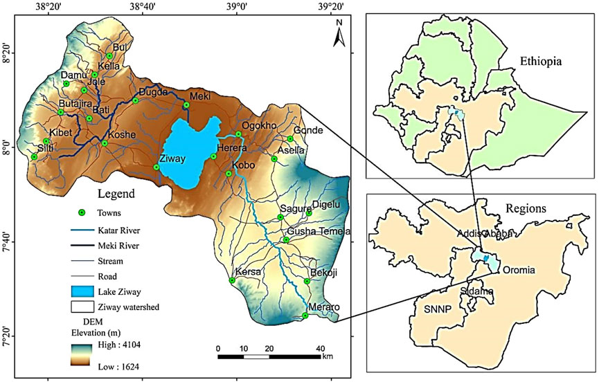
Figure 1. Location map of Lake Ziway watershed.
2.2 Data availability
This study utilized a wide array of primary and secondary data sources, ensuring a comprehensive analysis of the Lake Ziway watershed. Key datasets included satellite images, geological and hydrogeological maps, topographic maps, administrative boundaries, and field observations. Secondary data were obtained from peer-reviewed scientific literature, official government records, census reports, and project documentation. A summary of the data and their sources is presented in Table 1.
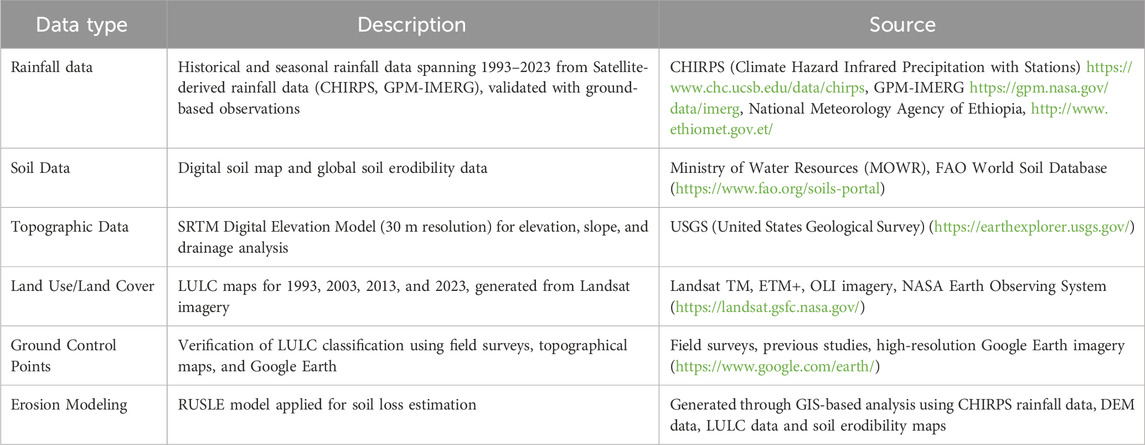
Table 1. Overview of data types, descriptions, and sources used in the study.
2.3 Data analysis and processing
Satellite-derived rainfall data from CHIRPS and GPM-IMERG were validated against ground-based observations to assess accuracy. A CHIRP demonstrated slightly higher performance and was subsequently used to develop a rainfall erosivity map employing Co-kriging interpolation in GIS. Soil depth mapping was conducted using the digital soil map from MOWR, while soil erodibility was analyzed using the FAO World Soil Database. The SRTM DEM (30 m resolution) facilitated watershed delineation, slope analysis, and drainage pattern mapping. LULC maps were generated using Landsat imagery through supervised classification and the maximum likelihood classifier algorithm in ERDAS Imagine software. Geometric corrections and atmospheric modifications were applied to improve accuracy. The Revised Universal Soil Loss Equation (RUSLE) model was utilized to estimate annual soil loss rates, integrating climatic, soil, topographic, and land cover data. The results were analyzed in the context of their implications for agricultural productivity and food security, supported by literature from peer-reviewed sources.
2.4 Calculation of RUSLE model parameters
The longitudinal study was conducted using data spanning three decade-long intervals: 1993, 2003, 2013, and 2023. These time slices were selected to capture long-term trends and variations in soil erosion influenced by climatic, land-use, and anthropogenic changes. The analysis employs the Revised Universal Soil Loss Equation (RUSLE), an empirically robust model for estimating long-term average annual soil erosion. Originally conceptualized by Wischmeier and Smith (1978) and later refined to RUSLE by Renard et al. (1997), this model has been widely adopted for soil erosion studies globally, including Ethiopia. For this study, localized adaptations to RUSLE, such as those developed by Hurni et al. (2015) for Ethiopian conditions, were incorporated to enhance accuracy and relevance. The study examines two key concepts of erosion:
1. Potential Erosion (Ap): Represents the maximum soil erosion rate assuming no erosion control or protective measures (P = 1) and a uniform cover condition (C = 1). It quantifies the inherent susceptibility of the landscape to erosion based on natural factors such as rainfall erosivity (R), soil erodibility (K), and topographic features (LS). The equation for potential erosion is expressed as:
2. Actual Modeled Erosion (Aa): Represents the actual soil erosion rate under current land use and management practices, accounting for the effects of vegetation cover (C) and support practices (P). The full RUSLE equation is used to calculate actual modeled erosion:
Where:
These definitions allow us to assess both the baseline susceptibility to erosion (potential erosion) and the impacts of land management practices (actual modeled erosion) across the three decade-long intervals: 1993, 2003, 2013, and 2023. By comparing potential and actual erosion, the study evaluates the effectiveness of erosion control measures and land use changes over time. In this study, RUSLE parameters were calculated using a combination of remote sensing data, field surveys, and GIS tools.
2.4.1 Rainfall-runoff erosivity factor (R)
Rainfall erosivity reflects the impact of raindrop detachment and surface runoff. The absence of detailed kinetic energy and intensity data in Ethiopia necessitates empirical alternatives. Two equations were evaluated: Hurni et al. (2015) formula, specific to Ethiopian highlands, and Dessalegn et al. (2017) regression model. This study used Hurni’s equation:
where, P is mean annual rainfall (mm), derived from 30 years (1993–2023) of CHIRPS satellite data.
2.4.2 Soil erodibility factor (K)
The K factor quantifies the susceptibility of soils to erosion based on texture, organic matter, structure, and permeability. Soil data were sourced from the Harmonized World Soil Database. Williams et al. (2008) equation, incorporating sand, silt, clay fractions, and organic carbon, was applied:
where, coefficients adjust K for soil texture and organic matter.
2.4.3 Slope length and steepness factor (LS)
The LS factor integrates topography into erosion estimation. GIS-derived DEM data enabled slope length and gradient calculations using Moore and Burch’s (1986) methodology. For Ethiopian highlands, this approach efficiently captured the spatial heterogeneity of erosion risk.
where, Af is the flow accumulation (pixels), C is the pixel size (m), and β is the slope angle in rad.
2.4.4 Cover management factor (C)
The C factor reflects land cover’s influence on soil loss. NDVI, calculated using Landsat images in Google Earth Engine, provided an annual average representation. Values were scaled following Gashaw et al. (2018).
2.4.5 Support practice factor (P)
The P factor accounts for erosion control practices, modeled based on land use and field observations. It represents the impact of conservation practices, such as contouring, buffer strips of dense vegetation, and terracing, on soil erosion when tilling up and down slopes (Wischmeier and Smith, 1978). Due to the large scale of the watershed in this study, obtaining well-organized data and consistent soil and water conservation practices proved challenging. Therefore, the method commonly adopted in most studies (Haregeweyn et al., 2015; Molla and Sisheber, 2017; Zerihun et al., 2018) involved grouping different LULC types into agricultural and non-agricultural lands was utilized to estimate the P value. Agricultural lands were further classified into various slope categories and assigned a P-value, while all non-agricultural lands were assigned a P-value of 1.00 as per the recommendation of (Balabathina et al., 2020). Subsequently, a corresponding P-value was assigned to each land use type using the reclass method in ArcGIS. The overall work flow of the study is indicated in Figure 2.

Figure 2. Work flow of the study.
3 Results and conclusions
3.1 RUSLE parameters
The soil loss rate with in the watershed area was estimated by using the RUSLE model by integrating the relative influences of soil erosion governing factors namely, rainfall erosivity (R), soil erodibility (K), topography (LS), cover management (C), and support practice (P) (Equations 1, 2).
3.1.1 Rainfall erosivity factor (R)
The R-factor, representing rainfall erosivity, is crucial in assessing the potential for soil erosion. In the Lake Ziway watershed, the computed R-factor values using Equation 3, ranged from 384.6 to 671.7 MJ mm ha−1 h−1year−1 in 1993, with an average of 659.05 MJ mm ha−1 h−1year−1. This value fluctuated slightly over the years, with ranges of 371.1–691.1 MJ mm ha−1 h−1year−1 (average 633.22 MJ mm ha−1 h−1year−1) in 2003, 374.4–704.4 MJ mm ha−1 h−1year−1 (average 672.52 MJ mm ha−1 h−1year−1) in 2013, and 350.2–699.6 MJ mm ha−1 h−1year−1 (average 672.52 MJ mm ha−1 h−1year−1) in 2023 (Figure 3). These values show a consistent pattern, with the highest R-factor observed in the highland areas and gradually decreasing towards the lake and arid rift regions. The R-factor values, representing rainfall erosivity in the Lake Ziway watershed, reveal a significant potential for soil erosion, particularly in the highland areas. Over the years, these values have ranged from 350.2 to 704.4 MJ mm ha−1 h−1year−1, with the highest values consistently observed in the western and eastern highlands, gradually decreasing towards the lake and arid rift regions. When compared to other regions in Ethiopia, such as the Tigray region and the Upper Blue Nile Basin, where R-factors range from 300 to 850 MJ mm ha−1 h−1year−1, the Lake Ziway watershed’s values align closely, indicating a similar erosion risk profile (Amanuel et al., 2018; Haregeweyn et al., 2017). In contrast, southern Ethiopia exhibits lower R-factors, ranging from 250 to 550 MJ mm ha−1 h−1year−1, reflecting the region’s lower rainfall intensity (Tamene and Vlek, 2008). Beyond Ethiopia, regions with comparable climatic conditions, like the highlands of Kenya and the Western Ghats of India, also show similar or higher R-factor values, underscoring the global relevance of these findings (Ngetich et al., 2016; Ganasri and Ramesh, 2016). The consistently high R-factor values in the Lake Ziway watershed’s highlands suggest a strong potential for erosion, emphasizing the need for targeted soil conservation efforts to protect these vulnerable areas and maintain agricultural productivity.
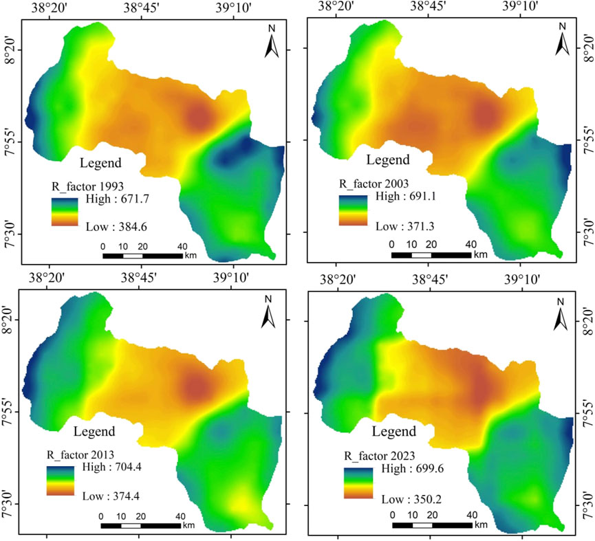
Figure 3. Rainfall erosivity over the analyzed periods (1993–2023).
3.1.2 Soil erodibility factor (K)
The calculated K-factor values in the Lake Ziway watershed reveal varying degrees of soil erodibility across different soil types by applying Equation 4. Clay-rich soils such as Vertic Cambisols and Eutric Vertisols exhibit lower K-factors (0.1316–0.1582), indicating a natural resistance to erosion due to their fine texture and high cohesion. However, these soils are not immune to erosion, especially under intensive land use or poor management practices. Sandy loam soils, like Lithic Leptosols and Vitric Andosols, with slightly higher K-factors (0.1303–0.1370), show moderate erodibility, necessitating careful management to prevent degradation, particularly during heavy rainfall when vegetation cover is sparse. Loam soils, represented by Humic Nitisols and Chromic Luvisols, fall within a mid-range K-factor (0.1273–0.1682), reflecting their balanced texture but still requiring effective soil conservation strategies to maintain productivity (Figure 4). When compared to findings from other parts of Ethiopia, these K-factor values align with studies in the Northern Highlands, where soils such as Cambisols and Leptosols also show moderate to high erodibility under similar rainfall conditions (Haregeweyn et al., 2017). In the Blue Nile Basin, K-factors are reported to range from 0.12 to 0.20, indicating that even small changes in soil management can significantly impact erosion rates (Gessesse et al., 2015). Similarly, in Kenya’s highlands, where rainfall patterns are comparable, K-factors for loam and sandy soils range from 0.13 to 0.17, underscoring the universal challenge of managing soil erosion in regions with intense seasonal rains (Ngetich et al., 2016). The higher K-factor values observed in the southeastern and northwestern parts of the Lake Ziway watershed, influenced by geological fault lines, suggest a heightened risk of erosion, particularly in areas where organic matter content is low and soil management practices are suboptimal (Balcha et al., 2022; Legesse et al., 2004). To mitigate these risks, it is crucial to implement erosion control measures such as maintaining ground cover and enhancing soil organic matter, which are vital for preserving soil quality and ensuring long-term agricultural productivity. The summary of soil type, soil texture, soil depth and K- values of the studied watershed is given in Figure 4.
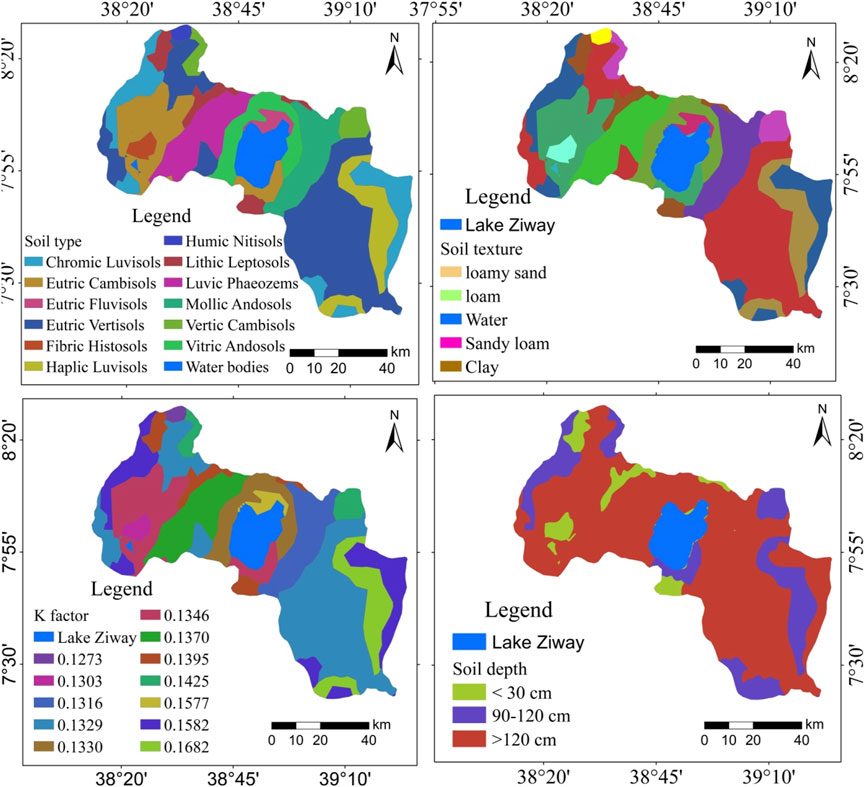
Figure 4. Soil type, soil texture, K values and soil depth of the study area.
3.1.3 Topographic factor (LS)
The LS-factor, which represents the combined effects of slope length and steepness on soil erosion, plays a critical role in determining erosion potential, particularly in regions with varied topography. In the Lake Ziway watershed, the LS-factor values calculated by applying Equation 5 range from 0.0 to 26.7 (Figure 5), with the highest values concentrated in the eastern and western parts of the watershed where steep slopes and longer slope lengths prevail. These elevated LS values indicate a significant risk of soil erosion, as the increased slope steepness and length accelerate overland flow, thereby enhancing the erosivity of runoff. Similar trends are observed in other parts of Ethiopia, such as the Blue Nile Basin, where LS-factor values can exceed 20 in steep and long-sloped areas, highlighting the severe erosion risk in these regions (Haregeweyn et al., 2017). In the Tigray highlands, LS factors also vary widely, with higher values found in areas of rugged terrain, contributing to substantial soil loss (Amanuel et al., 2018). In countries with similar topographic conditions, such as Kenya and Nepal, the LS-factor values reflect comparable erosion risks. In the Kenyan highlands, LS values ranging from 10 to 30 have been reported in areas with steep and lengthy slopes, emphasizing the need for robust soil conservation practices (Ngetich et al., 2016). In Nepal, where the Himalayan topography features extreme variations in slope, LS values often reach up to 35 in mountainous regions, resulting in severe erosion challenges (Sharma et al., 2020). These comparisons underscore the importance of topography in influencing erosion rates, as regions with high LS values, like the eastern and western parts of the Lake Ziway watershed, are particularly vulnerable to soil degradation. The interaction between slope steepness, slope length, and other factors such as land use and vegetation cover further amplifies erosion risks in these areas. Effective erosion control measures, such as terracing, contour plowing, and maintaining vegetative cover, are essential in high-risk zones to mitigate soil loss and sustain agricultural productivity.
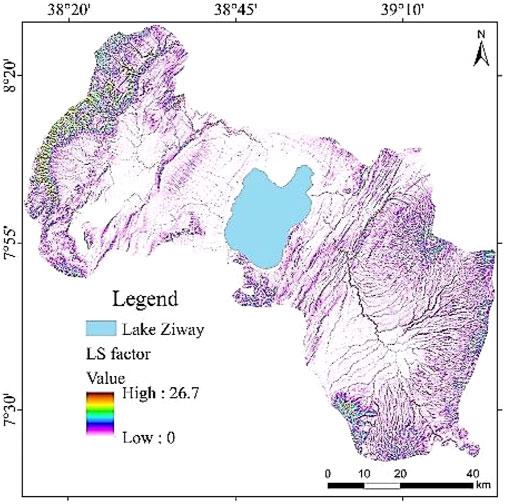
Figure 5. LS factor map of the study area.
3.1.4 Cover and management practice factor (C)
The C-factor in the Revised Universal Soil Loss Equation (RUSLE) offers a crucial insight into the impact of vegetation cover and management practices on soil erosion. In the Lake Ziway watershed, the C-factor values (computed by using Equation 6) from 1993 to 2023 show a notable range: 0.076 to 0.5 in 1993, 0.083 to 0.5 in 2003, 0.04 to 0.45 in 2013, and 0.049 to 0.46 in 2023 (Figure 6). These values highlight both the variability in erosion control effectiveness and the evolving practices over time. When comparing these trends with other regions, significant patterns emerge. In the Ethiopian Highlands, C-factor values have ranged from 0.05 to 0.55, reflecting similar variability in erosion control practices (Tadesse et al., 2019). In Kenya’s Rift Valley, C-factors have varied from 0.06 to 0.5, indicating comparable challenges and improvements in land management (Munyiri et al., 2021). In Tanzania, C-factors have ranged from 0.05 to 0.48, suggesting a moderate but consistent approach to erosion control (Kibret et al., 2020).
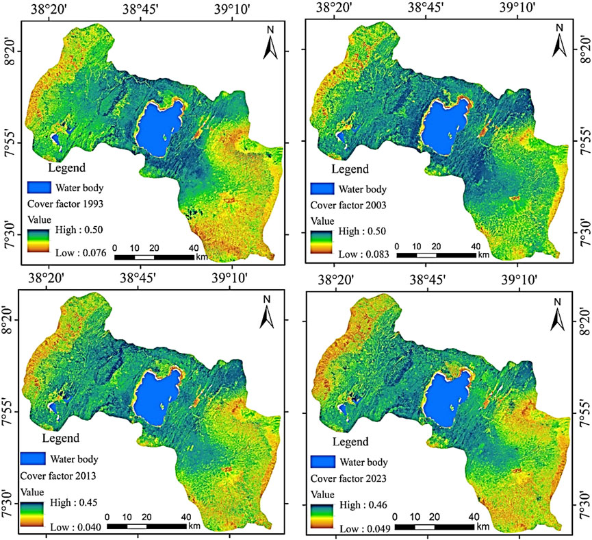
Figure 6. C-factor map of the study area over the analyzed periods.
The potential for erosion based on these C-factor values can be substantial. For instance, a C-factor of 0.5 signifies a high potential for erosion due to ineffective cover or management practices, while a lower C-factor, such as 0.04, suggests effective erosion control through improved vegetation cover or management strategies. The shifts observed from 1993 to 2023 in the Lake Ziway watershed indicate ongoing changes in LULC changes and land management practices. A sharp decline in forested areas was observed in 2003 (18.8% in 1993 to 5.8% in 2003). The reason for such catastrophic decline was that, the early 2000s in Ethiopia were characterized by widespread deforestation driven by agricultural expansion, population growth, and policy-driven land redistribution programs. These factors contributed to significant forest loss, particularly during this period (Pistorius et al., 2017). However, reforestation and afforestation initiatives began to gain momentum after 2003, which likely contributed to the observed rebound in forested areas in subsequent decades. Additionally, restoration initiatives implemented post-2003 played a crucial role in reversing the trend. Large-scale afforestation and reforestation efforts, such as community-based tree-planting programs and government-led projects, significantly increased forest cover (Zeleke and Vidal, 2020). Notable among these initiatives was the Green Legacy Program, which emphasized reforestation as a national priority. The improvement seen by 2013, with a lower range, suggests better erosion control efforts during that period, though the slight increases in C-factor range by 2023 points to some variability in effectiveness. The changes in LULC over the analyzed period are summarized in Table 2.
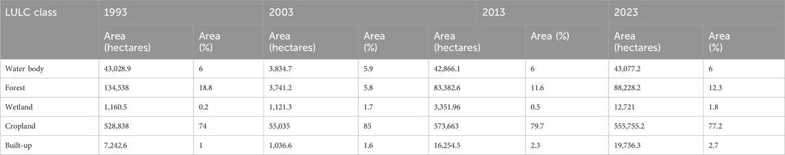
Table 2. LULC Types of the analyzed periods.
3.1.5 Conservation practice factor (P)
The P-factor in the Revised Universal Soil Loss Equation (RUSLE) is a crucial element for understanding soil erosion dynamics, particularly in relation to land use and slope gradients. In the Lake Ziway watershed, agricultural areas exhibit a P-factor ranging from 0.1 for flat slopes (0%–5%) to 0.33 for steeper slopes (30%–50%) (Table 3).
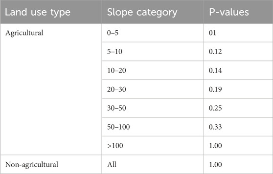
Table 3. Land use type, slope categories and P-values within the watershed area.
This variability reflects how slope steepness influences erosion: steeper slopes generally experience higher erosion rates due to increased runoff and reduced infiltration. Conversely, non-agricultural land consistently has a P-factor of 1.00, indicating a baseline potential for erosion that remains unchanged regardless of slope gradient (Figure 7). Comparing these findings with other regions highlights notable patterns. In the Ethiopian Highlands, P-factor values for agricultural areas range from 0.15 to 0.35, reflecting similar relationships between slope steepness and erosion risk (Meleseb, 2021). In Kenya’s Central Highlands, P-factors vary from 0.1 to 0.4, with steeper slopes exhibiting higher erosion potential due to limited soil conservation practices (Ngugi and Wambua, 2022). In Tanzania’s highland regions, agricultural areas have P-factors from 0.2 to 0.35, indicating a comparable impact of slope and land use on erosion (Shem, 2020). The potential for erosion based on these P-factor values is significant. Agricultural lands on steeper slopes, with higher P-factors, are more susceptible to erosion unless mitigated by effective conservation practices such as contour plowing or terracing. The uniform P-factor of 1.00 for non-agricultural lands underscores the importance of managing these areas to prevent potential erosion, especially when exposed to runoff. This highlights the need for integrated land use planning and erosion control measures across both agricultural and non-agricultural sectors to protect soil resources and maintain watershed health.
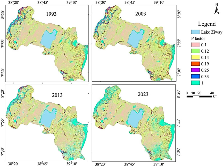
Figure 7. P-factor map of the study area over the analyzed periods.
3.2 RUSLE model analysis
The study employs the Revised Universal Soil Loss Equation (RUSLE) model to estimate potential and modeled actual soil loss rates in the Lake Ziway watershed over a 30-year period (1993–2023). This longitudinal analysis provides a systematic examination of soil erosion dynamics, offering insights into temporal trends, spatial patterns, and key drivers of soil degradation under varying land management and conservation practices. By spanning 3 decades, the study highlights the evolving interactions between environmental and anthropogenic factors, addressing critical knowledge gaps in soil conservation and management. Unlike cross-sectional studies, which provide a single snapshot, this longitudinal approach tracks changes in erosion rates over time, offering a nuanced understanding of how shifts in land use, population pressures, and climate conditions affect erosion processes.
In this context, “longitudinal” refers to a research design involving repeated analysis or estimations of soil erosion over an extended period. This design facilitates the identification of persistent erosion hotspots, the evaluation of conservation practices, and the cumulative impacts of environmental changes. The study distinguishes potential soil loss representing the maximum erosion rate under specific environmental conditions without conservation measures from modeled actual soil loss, which reflects real-world impacts adjusted by C (cover management) and P (support practices) factors. This distinction allows for a comprehensive assessment of the effectiveness of conservation measures while providing insights into the watershed’s erosion vulnerability. Table 4 highlights how each factor contributes to the differences between actual and potential erosion.
Table 4. Comparison of RUSLE factors for potential and actual soil loss.
The findings reveal that potential soil loss in 1993 ranged from 0 to 2,082 t/ha/yr, with a total annual loss of approximately 3.76 million tonnes, decreasing slightly to 0–2,069 t/ha/yr and 3,479,980 tonnes in 2023 (Figure 7). Modeled actual soil loss also declined, ranging from 0 to 1,527 t/ha/yr in 1993 (totaling 2,578,871 tonnes annually) to 0–1,463 t/ha/yr in 2023 (totaling 2,298,790 tonnes) (Figure 8). The mean soil loss rates for potential erosion increased slightly from 42.91 t/ha/yr in 1993 to 43.73 t/ha/yr in 2023, while modeled actual erosion rates rose from 38.79 t/ha/yr to 41.01 t/ha/yr during the same period. These values consistently exceed Ethiopia’s acceptable soil loss threshold of 10–15 t/ha/yr (Meleseb, 2021), highlighting significant challenges in managing soil erosion. The areas shown in red in Figures 8, 9 are identified as erosion risky areas.
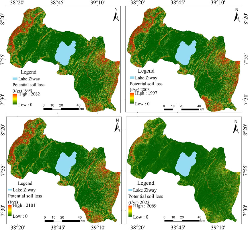
Figure 8. Analyzed potential soil loss over the 3 decades.
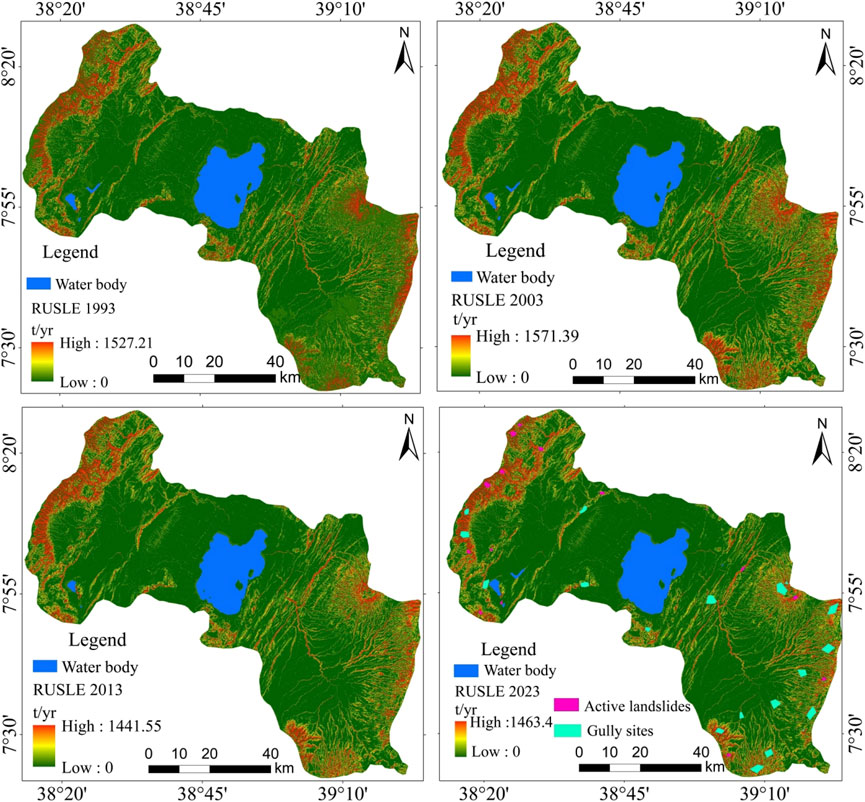
Figure 9. Modeled actual soil loss over the 3 decades (1993–2023).
The estimated erosion rates (given in t/ha/yr) and total erosion (given in tonnes) values reflect the influence of large-scale environmental and anthropogenic factors driving soil erosion in the study area. The findings are indeed plausible and consistent with results from large-scale watershed studies in regions with similar physiographic and climatic conditions. For example, Tamene and Vlek (2008) estimated annual soil losses of 4.5–8.6 million tonnes in the Ethiopian Highlands due to steep slopes and unsustainable land-use practices. Similarly, Zhang et al. (2013) reported annual soil losses exceeding 10 million tonnes in the Loess Plateau in China, where high rainfall intensity and extensive agricultural activities exacerbate soil erosion. The Lake Ziway watershed, characterized by steep highlands transitioning into flatter plains, encompasses a substantial area. Larger watersheds often report high absolute erosion totals due to the cumulative contributions of individual sub-watersheds. Such findings align with studies conducted in comparable contexts, such as the Blue Nile Basin, where soil erosion rates exceeding millions of tonnes annually have been documented.
The analysis of mean annual soil loss provides a broad perspective on erosion; however, examining the range and maximum soil loss values uncovers critical localized impacts. The study highlights substantial variability in erosion rates within the watershed, with elevated rates predominantly observed in areas characterized by steep slopes, deforestation, or unsustainable agricultural practices. This variability emphasizes the necessity of analyzing local-scale erosion dynamics, as relying solely on average values may obscure high-risk zones. For instance, while zero soil loss values appear on erosion maps due to mapping scales, they are not fully representative of the watershed’s overall condition. Addressing high-risk zones that contribute disproportionately to sediment yield remains imperative.
Model validation was conducted through field-based observations, including GPS-documented gully mapping and landslide inventories. Notably, almost all active gullies and landslides were found to align with areas identified as high-risk for erosion, underscoring the spatial connection between extreme erosion events and geomorphological vulnerabilities [Figure 8 (2023)]. The findings were further corroborated through comparisons with existing literature from other adjacent regions with similar studies. For example, Teku et al. (2024) estimated the total annual potential soil loss in the Upper Meki catchment, adjacent to the present study area, at approximately 2,756,540 tonnes. Similarly the study showed an estimated annual potential soil loss ranging from 0 to 6,120.22 t/ha/yr, with a mean rate of 28.12 ± 34.77 t/ha/yr. In the same way, the actual annual soil loss for the Upper Meki catchment was approximately 492,929 t/yr, with an erosion rate of 37.05 ± 46.7 t/ha/yr. Tesema (2015) reported a comparable mean soil loss rate of 24.85 t/ha/yr in the Cheraque watershed, located to the south of the present study area. These findings indicate that the estimated erosion rate in the current study is closely aligned with those observed in adjacent watersheds, reinforcing the robustness and reliability of the results.
The longitudinal analysis highlights the interplay between natural and human-induced factors, showing how conservation measures have mitigated erosion rates while increasing rainfall erosivity and expanding agricultural activities into marginal lands have counteracted these efforts. Evidence from the Ethiopian Highlands supports these observations, where rising rainfall intensity has exacerbated soil loss. Additionally, the inadequate maintenance of conservation structures has limited their long-term efficacy, leading to slight upward trends in actual erosion rates over time. This emphasizes the need for sustained monitoring and adaptive management strategies informed by historical data on land use and climatic variability. The study underscores the urgent need for effective soil conservation measures, such as terracing, contour farming, and reforestation, alongside policies that promote community engagement, financial incentives, and robust implementation frameworks. The results demonstrate that targeted conservation strategies can mitigate soil erosion, sustain agricultural productivity, and preserve watershed health. While the RUSLE model provides valuable insights, its limitations, including dependency on input data resolution and exclusion of certain erosion processes, must be acknowledged. Future research should integrate higher-resolution datasets and advanced modeling techniques to improve predictive accuracy. By analyzing data spanning 3 decades, this study offers actionable insights for evidence-based policymaking, promoting sustainable land management practices to address the persistent challenge of soil erosion in the Lake Ziway watershed.
4 Implications of RUSLE values for agricultural sustainability and food security
The longitudinal analysis of Revised Universal Soil Loss Equation (RUSLE) values in the Lake Ziway watershed, which consistently reveals mean soil loss rates exceeding 40 t/ha/yr, has significant implications for agricultural sustainability and food security both within the watershed and for Ethiopia as a whole. This excessive soil loss depletes the topsoil, which is crucial for nutrient availability, soil structure, and water retention. The removal of nutrient-rich topsoil compromises soil fertility, leading to reduced crop yields and increased dependency on chemical fertilizers to maintain productivity (Lal, 2020). Globally, similar patterns have been observed in regions with high erosion rates. For instance, in the Loess Plateau of China, soil erosion has led to severe land degradation, necessitating substantial investments in soil conservation practices to restore productivity (Liu et al., 2019). Likewise, similar patterns have been observed in regions such as sub-Saharan Africa, where soil erosion has been a significant factor in food insecurity. For example, in the Sahel region, high erosion rates have been linked to decreased agricultural productivity and increased food insecurity, necessitating large-scale soil conservation efforts to improve food security (Lal, 2020). These examples underscore the importance of addressing soil erosion as a critical component of food security strategies.
In Ethiopia, where agriculture is a key component of the economy and a primary source of livelihood for many, soil erosion has been linked to food insecurity (Gedefaw et al., 2021). Although some increase in cereal productivity has been observed over the past years, the current productivity of most cereals in the CRV is still less than 3 t ha− 1, while the population increases with 2%–3% per year, underlining the challenge to feed the population from the currently cultivated land (Geological Survey of Ethiopia, 2010). According to the study by Megersa et al. (2022), in Ethiopia Climate change induced erosion has reduced crop yield by 15%–25% for wheat and 2%–30% for maize. A more recent study by Tullu (2024), revealed that in Ethiopia the crop damage associated with climate change induced erosion adversely affect yields to 36%, subsequently hampering food security of at least 40% of farmers during the agricultural season. While district- or watershed-level agricultural production data for the study area remains unavailable, national crop yield trends are utilized as a proxy to underscore the broader implications of land degradation on food security (World Bank, 2018). Cereal production in Ethiopia exhibits significant variability, with periods of fluctuation from 1980 to 2010, followed by a consistent upward trend from 2010 to 2020. However, this positive trajectory experienced a brief decline in 2021 before resuming an increase from 2022 onward (Central Statistical Agency, 2023). These gains, while encouraging at the national level, may obscure localized productivity losses caused by severe soil erosion, such as those documented in the Lake Ziway watershed. The trends observed in the Lake Ziway watershed mirror these concerns, highlighting the need for urgent action to address soil erosion and its impacts on food security.
The persistent high erosion rates in the Lake Ziway watershed align with broader national trends, where soil erosion threatens agricultural productivity and requires comprehensive land management strategies to mitigate its effects (Meleseb, 2021). Effective measures, such as contour farming, terracing, and agroforestry, have been demonstrated to significantly reduce soil loss and improve land productivity in similar contexts (Bai et al., 2018). Implementing these practices in the Lake Ziway watershed could help restore soil health and enhance agricultural sustainability. To address the severe soil erosion observed in the Lake Ziway watershed, a multifaceted approach is needed. Effective soil conservation strategies include implementing contour plowing, constructing check dams, and promoting agroforestry practices to stabilize soil and reduce erosion (Bai et al., 2018). Additionally, integrating traditional knowledge with modern conservation techniques can enhance the effectiveness of these measures and ensure they are well-suited to local conditions (Teku et al., 2024). Furthermore, promoting sustainable land management practices through education and capacity building can empower local communities to take proactive measures in managing soil erosion and improving agricultural productivity. Collaborations between government agencies, non-governmental organizations, and local communities are essential to develop and implement effective soil conservation strategies and ensure their sustainability.
5 Recommendations
This study highlights the urgent need for evidence-based and region-specific strategies to mitigate the escalating problem of soil erosion in the Lake Ziway watershed. The findings reveal erosion rates that exceed acceptable thresholds, necessitating immediate and long-term interventions to safeguard environmental health, agricultural productivity, and community livelihoods. In the short term, implementing targeted erosion control measures is imperative. Practices such as terracing, reforestation of critical areas, and establishing vegetative buffers along waterways can substantially reduce sediment runoff and protect topsoil. Equally important is engaging local communities through participatory approaches that enhance ownership and ensure the adoption of conservation-friendly agricultural practices, including contour plowing and cover cropping. Establishing high-resolution monitoring systems to track erosion hotspots and inform adaptive management strategies is essential for timely and effective interventions.
Long-term solutions require robust policy frameworks that incentivize sustainable land management practices and address underlying drivers such as deforestation and overgrazing. Policymakers should prioritize regulations that promote conservation agriculture and penalize unsustainable land-use practices. In addition, integrating soil conservation awareness into educational curricula and outreach initiatives can foster a culture of environmental stewardship among diverse stakeholders. Leveraging advanced technologies, such as predictive modeling tools that incorporate climate data and socio-economic trends, can further enhance decision-making and facilitate adaptive management. The implications of these strategies extend beyond ecological restoration. Effective mitigation of soil erosion in the Lake Ziway watershed is critical to preserving water quality, maintaining ecosystem health, and enhancing food security. A multi-stakeholder approach involving government entities, academic institutions, non-governmental organizations, and local communities will be pivotal in achieving sustainable outcomes and building resilience against future environmental uncertainties.
6 Conclusion
This study demonstrates the application of the Revised Universal Soil Loss Equation (RUSLE) as an essential tool for assessing soil erosion and land degradation in the Lake Ziway watershed, providing new insights into its effectiveness as a longitudinal framework. By employing RUSLE over 3 decades, the research captures temporal trends and spatial patterns in soil erosion, offering a comprehensive evaluation of both the dynamics and drivers of erosion in the study area. The novel contribution of this research lies in its detailed integration of RUSLE with region-specific data, enabling a nuanced understanding of erosion processes in a rapidly changing environmental context. The study reveals that while soil conservation efforts have led to modest reductions in total soil loss, erosion rates have declined from 3.76 million tonnes annually in 1993 to 3.48 million tonnes annually in 2023. However, the current erosion rates of 43.73 t/ha/yr remain well above the tolerable threshold of 10–15 t/ha/yr, indicating persistent challenges in managing soil erosion effectively. This highlights the persistent challenge of managing soil erosion effectively under conditions of increasing rainfall intensity, unsustainable land-use practices, and population pressures. The findings underscore the robustness of RUSLE in capturing these complex interactions, making it a vital tool for longitudinal erosion and land degradation assessments.
A key strength of RUSLE is its ability to integrate multiple factors rainfall, soil erodibility, topography, land cover, and conservation practices into a cohesive framework for modeling soil loss across varying spatial and temporal scales. In this study, RUSLE proved invaluable in identifying erosion hotspots and evaluating the long-term effectiveness of implemented conservation measures. However, the results also reveal significant gaps in the sustainability and maintenance of these practices, necessitating more robust interventions to achieve lasting reductions in soil loss. By providing actionable data on erosion risks and the efficacy of mitigation strategies, this research not only validates RUSLE as a dynamic and adaptable tool but also contributes to advancing sustainable land management practices. The longitudinal approach adopted here offers a replicable model for other regions facing similar challenges, enhancing RUSLE’s utility in addressing the dual threats of soil degradation and climate change.
In conclusion, this study underscores the critical importance of integrating evidence-based tools like RUSLE into soil conservation planning and policymaking. The ability of RUSLE to assess erosion trends over time provides a valuable foundation for designing adaptive strategies that balance agricultural productivity with ecological sustainability. As the Lake Ziway watershed continues to confront mounting environmental pressures, the insights gained from this research serve as a clarion call for concerted action to restore and preserve soil health, ensuring the resilience of both ecosystems and communities for future generations.
Data availability statement
The original contributions presented in the study are included in the article/supplementary material, further inquiries can be directed to the corresponding author.
Author contributions
DT: Conceptualization, Data curation, Formal Analysis, Funding acquisition, Investigation, Methodology, Project administration, Resources, Software, Supervision, Validation, Visualization, Writing–original draft, Writing–review and editing. MW: Conceptualization, Data curation, Formal Analysis, Funding acquisition, Investigation, Methodology, Project administration, Resources, Software, Supervision, Validation, Visualization, Writing–original draft, Writing–review and editing.
Funding
The author(s) declare that no financial support was received for the research, authorship, and/or publication of this article.
Conflict of interest
The authors declare that the research was conducted in the absence of any commercial or financial relationships that could be construed as a potential conflict of interest.
Generative AI statement
The author(s) declare that no Generative AI was used in the creation of this manuscript.
Publisher’s note
All claims expressed in this article are solely those of the authors and do not necessarily represent those of their affiliated organizations, or those of the publisher, the editors and the reviewers. Any product that may be evaluated in this article, or claim that may be made by its manufacturer, is not guaranteed or endorsed by the publisher.
References
Aga, A. O., Chane, B., and Melesse, A. M. (2018). Soil erosion modelling and risk assessment in data scarce rift valley lake regions, Ethiopia. Water 10 (11), 1684–1717. doi:10.3390/w10111684
Amanuel, Z., Amare, B., and Adgo, E. (2018). Estimation of rainfall erosivity factor for selected watersheds of Tigray, northern Ethiopia. J. Environ. Hydrology 26 (4), 1–10.
Bai, Z., Dent, D., Olsson, L., and Schaepman, M. (2018). “Global assessment of land degradation and improvement: 1,” in Identification by remote sensing. FAO: University of Zurich. Report 2008/07.
Balabathina, V. N., Raju, R. P., Mulualem, W., and Tadele, G. (2020). Estimation of soil loss using remote sensing and GIS-based universal soil loss equation in northern catch¬ment of Lake Tana Sub-basin, Upper Blue Nile Basin, Northwest Ethiopia. Environ. Syst. Res. 9 (1), 1–32. doi:10.1186/s40068-020-00203-3
Balcha, G., Legesse, G., Tesfaye, A., and Woldeyohannes, M. (2022). Soil erosion risk assessment and management implications in the Lake Ziway watershed, Central Rift Valley, Ethiopia. J. Soil Water Conservation 77 (2), 145–160.
Bekele, D. A., Gella, G. W., and Ejigu, M. A. (2022). Erosion risk assessment: acontribution for conservation priority area identification in the sub-basin of Lake Tana, north-western Ethiopia. Int. Soil Water Conservation Res. 10 (1), 46–61. doi:10.1016/j.iswcr.2021.04.010
Berendse, F., van Ruijven, J., Jongejans, E., and Keesstra, S. (2015). Loss of plant species diversity reduces soil erosion resistance. Ecosystems 18 (5), 881–888. doi:10.1007/s10021-015-9869-6
Bishaw, B. (2009). Deforestation and land degradation in the Ethiopian highlands: a strategy for physical recovery. Ethiop. E-journal Res. innovation foresight 1 (1), 5–18.
Borrelli, P., Robinson, D. A., Panagos, P., Lugato, E., Yang, J. E., Alewell, C., et al. (2020). Land use and climate change impacts on global soil erosion by water (2015-2070). Proc. Natl. Acad. Sci. 117 (36), 21994–22001. doi:10.1073/pnas.2001403117
Central Statistical Agency (CSA) (2023). Agricultural sample survey 2023: report on area and production of major crops private peasant holdings, meher season. Addis Ababa, Ethiop. Cent. Stat. Agency.
Desalegn, A., Tezera, A., and Tesfay, F. (2018). Developing GIS-based soil erosion map using RUSLE of Andit Tid Watershed, central highlands of Ethiopia. J. Sci. Res. Rep. 19 (1), 1–13. doi:10.9734/jsrr/2018/40841
Dessalegn, T. A., Moges, M. A., Dagnew, D. C., and Gashaw, A. (2017). Applicability of galway river flow forecasting and modeling system (GFFMS) for lake tana basin, Ethiopia. J. Water Resour. Prot. 9 (12), 1319–1334. doi:10.4236/jwarp.2017.912084
Elias, E., Gessesew, W. S., Tesfaye, B., and Girmay, W. (2018). Land use land cover changes and their impact on the lake ecosystem of the Central Rift Valley of Ethiopia.
FAO (2015). Agriculture organization: status of the world’s soil resources (SWSR)–Main report. Food Agric. Organ. U. N. Intergov. Tech. Panel Soils, Rome, Italy.
Ganasri, B. P., and Ramesh, H. (2016). Assessment of soil erosion by RUSLE model using remote sensing and GIS-A case study of Nethravathi Basin. Geosci. Front. 7 (6), 953–961. doi:10.1016/j.gsf.2015.10.007
Gashaw, T., Tulu, T., and Argaw, M. (2018). Erosion risk assessment for prioritization of conservation measures in Geleda watershed, Blue Nile basin, Ethiopia. Environ. Syst. Res. 6 (1), 1–14. doi:10.1186/s40068-016-0078-x
Gedefaw, M., Haji, J., and Tesfaye, G. (2021). Impact of soil erosion on agricultural productivity and food security in Ethiopia: a case study. Ethiop. J. Agric. 29 (1), 45–58.
Geological Survey of Ethiopia (GSE) (2010). “Geology of the akaki-beseka area,” in Basic geoscience mapping core process, addis ababa, Ethiopia.
Gessesse, B., Bewket, W., and Bräuning, A. (2015). Soil and water conservation effects on soil properties in the middle and lower zones of the northwestern highlands of Ethiopia. Land Degrad. and Dev. 26 (7), 676–685.
Getu, L. A., Nagy, A., and Addis, H. K. (2022). Soil loss estimation and severity mapping using the RUSLE model and GIS in Megech watershed, Ethiopia. Environ. Challenges 8, 100560. doi:10.1016/j.envc.2022.100560
Goshime, D. W., Haile, A. T., Rientjes, T., Absi, R., Ledésert, B., and Siegfried, T. (2021). Implications of water abstraction on the interconnected Central Rift Valley Lakes sub-basin of Ethiopia using WEAP. J. Hydrology Regional Stud. 38, 100969. doi:10.1016/j.ejrh.2021.100969
Hailesilassie, W. T., Ayenew, T., and Tekleab, S. (2021). Analysing trends and spatio-temporal variability of precipitation in the main Central Rift Valley lakes basin, Ethiopia. Environ. and Earth Sci. Res. J. 8 (1), 37–47. doi:10.18280/eesrj.080104
Haregeweyn, N., Tsunekawa, A., Nyssen, J., Poesen, J., Tsubo, M., Tsegaye Meshesha, D., et al. (2015). Soil erosion and conservation in Ethiopia: a review. Prog. Phys. Geogr. 39 (6), 750–774. doi:10.1177/0309133315598725
Haregeweyn, N., Tsunekawa, A., Poesen, J., Nyssen, J., Tsubo, M., Meshesha, D. T., et al. (2017). Comprehensive assessment of soil erosion risk for better land use planning in river basins: case study of the Upper Blue Nile River. Sci. Total Environ. 574, 95–108. doi:10.1016/j.scitotenv.2016.09.019
Hurni, K., Zeleke, G., Kassie, M., Tegegne, B., Kassawmar, T., Teferi, E., et al. (2015). Economics of Land Degradation (ELD) Ethiopia Case Study: soil degradation and sustainable land management in the rainfed agricultural areas of Ethiopia: an assessment of the economic implications.
Kalsido, T., and Berhanu, B. (2020). Impact of land-use changes on sediment load and capacity reduction of Lake Ziway, Ethiopia. Nat. Resour. 11 (11), 530–542. doi:10.4236/nr.2020.1111031
Kibret, A., Getachew, M., and Gashaw, T. (2020). Soil erosion assessment and management in Tanzania. Soil Sci. Soc. Am. J. 84 (5), 1364–1375.
Lal, R. (2020). “Soil erosion and conservation: past and present,” in Soil and water conservation for the future (USA: CRC Press).
Legesse, D., Vallet-Coulomb, C., and Gasse, F. (2004). Analysis of the hydrological response of a tropical terminal lake, Lake Abiyata (Main Ethiopian Rift Valley) to changes in climate and human activities. Hydrol. Process. 18 (3), 487–504. doi:10.1002/hyp.1334
Liu, J., Yang, W., and Zhang, Z. (2019). Soil erosion and its impact on land degradation in the Loess Plateau of China. Environ. Sci. and Policy 100, 96–104.
Mbow, C. (2020). Use it sustainably or lose it! the land stakes in SDGS for sub-Saharan Africa. Land 9 (3), 63. doi:10.3390/land9030063
Megersa, G., Tesfaye, K., Getnet, M., Jaleta, M., Tana, T., and Lakew, B. (2022). Potential impacts of climate change on wheat and barley production in Central Ethiopia
Meleseb, T. (2021). Soil erosion dynamics in the Ethiopian Highlands: an analysis of land use and slope effects. Ethiop. J. Environ. Stud. 15 (3), 211–225.
Merritt, W. S., Letcher, R. A., and Jakeman, A. J. (2003). A review of erosion and sediment transport models. Environ. Model. and Softw. 18 (8-9), 761–799. doi:10.1016/s1364-8152(03)00078-1
Meshesha, D. T., Tsunekawa, A., Tsubo, M., and Haregeweyn, N. (2012). Dynamics and hotspots of soil erosion and management scenarios of the Central Rift Valley of Ethiopia. Int. J. Sediment Res. 27 (1), 84–99. doi:10.1016/s1001-6279(12)60018-3
Molla, T., and Sisheber, B. (2017). Estimating soil erosion risk and evaluating erosion control measures for soil conservation planning at Koga watershed in the highlands of Ethiopia. Solid earth. 8 (1), 13–25. doi:10.5194/se-8-13-2017
Moore, I. D., and Burch, G. J. (1986). Physical basis of the length-slope factor in the universal soil loss equation. Soil Sci. Soc. Am. J. 50 (5), 1294–1298. doi:10.2136/sssaj1986.03615995005000050042x
Munyiri, F. S., Nyamweya, C. S., and Njonge, J. T. (2021). Soil erosion and its management in Kenya's Rift Valley. Environ. Monit. Assess. 193 (11), 712.
Negasa, D. J. (2023). The perception of farmers on soil erosion and conservation measures in the surrounding areas of Lake Ziway, Central Rift Valley of Ethiopia. Appl. Environ. Soil Sci. 2023 (1), 1–16. doi:10.1155/2023/6288288
Ngetich, K. F., Diels, J., Mugwe, J., Mucheru-Muna, M., and Mugendi, D. (2016). Soil erosion assessment in a highland agro-ecosystem using RUSLE. Agric. Ecosyst. and Environ. 224, 55–68.
Ngugi, M., and Wambua, M. (2022). Impact of slope gradient and land use on soil erosion in Kenya's Central Highlands. Afr. J. Agric. Res. 18 (6), 1129–1142.
Nyssen, J., Poesen, J., Lanckriet, S., Jacob, M., Moeyersons, J., Haile, M., et al. (2015) “Land degradation in the Ethiopian highlands,” in Landscapes and landforms of Ethiopia, 369–385.
Pal, S. C., and Chakrabortty, R. (2022). “Soil loss estimation using different empirical and semi-empirical models,” in Climate change impact on soil erosion in sub-tropical environment: application of empirical and semi-empirical models (Cham: Springer International Publishing), 67–87.
Pistorius, T., Carodenuto, S., and Wathum, G. (2017). Implementing forest landscape restoration in Ethiopia. Forests 8 (3), 61. doi:10.3390/f8030061
Renard, K. G., McCool, D. K., Cooley, K. R., Foster, G. R., Istok, J. D., Mutchler, C. K., et al. (1997). Rainfall-runoff erosivity factor (R). Predicting Soil Erosion by Water–A Guide to Conservation Planning with the Revised Universal Soil Loss Equation (RUSLE)
Seyoum, W. M., Milewski, A. M., and Durham, M. C. (2015). Understanding the relative impacts of natural processes and human activities on the hydrology of the Central Rift Valley lakes, East Africa. Hydrol. Process. 29 (19), 4312–4324. doi:10.1002/hyp.10490
Sharma, P., Khanal, N. R., and Mool, P. K. (2020). Assessment of soil erosion using RUSLE model in a high mountainous watershed of Nepal. Environ. Earth Sci. 79 (5), 152.
Shem, T. (2020). Assessment of erosion control practices in Tanzanian highlands. Int. Soil Water Conservation Res. 8 (2), 91–105.
Tadesse, T., Woldemariam, T., and Abate, M. (2019). Comparative analysis of soil erosion in the Ethiopian Highlands. J. Soil Water Conservation 74 (2), 146–158.
Tamene, L., Park, S. J., Dikau, R., and Vlek, P. L. G. (2006). Analysis of factors determining sediment yield variability in the highlands of northern Ethiopia. Geomorphology 76 (1-2), 76–91. doi:10.1016/j.geomorph.2005.10.007
Tamene, L., and Vlek, P. L. G. (2008). Soil erosion studies in northern Ethiopia and southern Mali. Land use. Land Cover Soil Sci. 3, 3–28.
Teku, D., Kesete, N., and Abebe, A. (2024). GIS based annual soil loss estimation with revised universal soil loss equation (RUSLE) in the upper Meki sub-catchment, rift valley sub-basin, Ethiopia. Cogent Food and Agric. 10 (1), 1–19. doi:10.1080/23311932.2024.2311802
Tesema, T. A. (2015). “GIS-based time series assessment of soil erosion risk using RUSLE Model: a case study of Cheraqe watershed, Bilate river sub-basin,” in Thesis submitted to college of natural science School of graduate studies center for environmental science [doctoral dissertation]. Addis Ababa: Addis Ababa university [Google scholar].
Tesfahunegn, G. B. (2011). Soil erosion modeling and soil quality evaluation for catchment management strategies in northern Ethiopia Doctoral dissertation. German: Universitäts-und Landesbibliothek Bonn.
Thiombiano, L., and Tourino-Soto, I. (2007). “Status and trends in land degradation in Africa,” in Climate and land degradation (Berlin, Heidelberg: Springer Berlin Heidelberg), 39–53.
Tsegaye, L., and Bharti, R. (2021). Soil erosion and sediment yield assessment using RUSLE and GIS-based approach in Anjeb watershed, Northwest Ethiopia. SN Appl. Sci. 3, 582–619. doi:10.1007/s42452-021-04564-x
Tullu, K. T. (2024). Assessment of soil erosion response to climate change in the Sululta catchment, Abbay Basin, Ethiopia. H2Open J. 7 (1), 23–37. doi:10.2166/h2oj.2023.083
Williams, J. R., Arnold, J. G., Kiniry, J. R., Gassman, P. W., and Green, C. H. (2008). History of model development at Temple, Texas. Hydrological Sci. J. 53 (5), 948–960. doi:10.1623/hysj.53.5.948
Wischmeier, W. H., and Smith, D. D. (1978). Predicting rainfall erosion losses: a guide to conservation planning (No. 537). USA: Department of Agriculture, Science and Education Administration.
Woldesenbet, A. B., Wudmatas, S. D., Denboba, M. A., and Gebremariam, A. G. (2020). Enset-based land use land cover change detection and its impact on soil erosion in Meki river watershed, Western Lake Ziway Sub-Basin, Central Rift Valley of Ethiopia. Environ. Syst. Res. 9, 37–23. doi:10.1186/s40068-020-00198-x
World Bank (2018). Ethiopia economic update: the inescapable manufacturing-services nexus. USA: World Bank.
Zanchin, M., Moura, M. M. D., Nunes, M. C. M., Beskow, S., Miguel, P., Lima, C. L. R. D., et al. (2021). Soil loss estimated by means of the RUSLE model in a subtropical climate watershed. Rev. Bras. Ciência do Solo 45, e0210050. doi:10.36783/18069657rbcs20210050
Zeleke, A., and Vidal, A. (2020). Contributing to scaling up forest landscape restoration in Ethiopia. Restor. Diagnostic Appl. Sodo Guragie (SNNPR) Meket (Amhara Region) Woredas.
Zerihun, M., Mohammedyasin, M. S., Sewnet, D., Adem, A. A., and Lakew, M. (2018). Assessment of soil erosion using RUSLE, GIS and remote sensing in NW Ethiopia. Geoderma Reg. 12, 83–90. doi:10.1016/j.geodrs.2018.01.002
Zerihun, W., and Mesfin, E. (1990). The status of the vegetation in the Lakes Region of the Rift Valley of Ethiopia and the possibilities of its recovery. Sinet 13 (2), 97–120.
Keywords: crop production, food access, Lake Ziway watershed, RUSLE model, soil erosion risk
Citation: Teku D and Workie MD (2025) Longitudinal analysis of soil erosion dynamics using the RUSLE model in Ethiopia’s Lake Ziway watershed: implications for agricultural sustainability and food security. Front. Environ. Sci. 12:1506001. doi: 10.3389/fenvs.2024.1506001
Received: 04 October 2024; Accepted: 23 December 2024;
Published: 20 January 2025.
Edited by:
Danijel Jug, Josip Juraj Strossmayer University of Osijek, CroatiaReviewed by:
Deirdre Dragovich, The University of Sydney, AustraliaEugenio Straffelini, University of Padua, Italy
Copyright © 2025 Teku and Workie. This is an open-access article distributed under the terms of the Creative Commons Attribution License (CC BY). The use, distribution or reproduction in other forums is permitted, provided the original author(s) and the copyright owner(s) are credited and that the original publication in this journal is cited, in accordance with accepted academic practice. No use, distribution or reproduction is permitted which does not comply with these terms.
*Correspondence: Degfie Teku, ZGVnZmllMjAyM0BnbWFpbC5jb20=