 Xing Jinbing1
 Zhai Tianlun
95% of researchers rate our articles as excellent or good
Learn more about the work of our research integrity team to safeguard the quality of each article we publish.
Find out more
ORIGINAL RESEARCH article
Front. Environ. Sci. , 16 October 2024
Sec. Biogeochemical Dynamics
Volume 12 - 2024 | https://doi.org/10.3389/fenvs.2024.1493390
This article is part of the Research Topic Mechanisms of Hydrochemical Evolution and Material Cycling Processes in Different Aquatic Systems Under the Influence of Human Activities View all articles
Examining the chemical properties of river water and the controlling factors is crucial for devising efficacious strategies in water resources management and ecological conservation. This study investigates the hydrochemical characteristics and driving factors of the Beichuan River in the arid region of Northwest China. Surface water samples were collected during wet and dry seasons, and analyzed using hydrochemical diagrams, mathematical statistics, and principal component analysis (PCA). The results show that the pH value of Beichuan River is generally weakly alkaline, the main hydrochemical types are HCO3-Ca, and the average TDS are 224 mg/L and 236 mg/L respectively, which are higher than the world average level (115 mg/L). The seasonal variation of hydrochemical components is mainly controlled by rainfall, showing that the concentrations of Na+, Cl− and NO3− in the wet season are higher than those in the dry season, while the concentrations of other chemical components show an opposite trend, while the spatial variation is mainly controlled by human activities, and the concentrations of hydrochemical components show a gradual increasing trend from upstream to downstream, especially Na+, Mg2+, Cl− and NO3−. Rock weathering is the key natural factor controlling the Hydrochemical Composition of Beichuan River. Na+ and Cl− are mainly from the dissolution of silicate, Ca2+ and Mg2+ are mainly from the weathering of carbonate rocks and silicate, and SO42- is mainly from the dissolution of evaporite. It is noted that human activities, especially domestic sewage and agricultural runoff, contribute significantly to NO3− in the water body. PCA identified rock weathering and agricultural runoff as major wet-season factors, while domestic sewage predominantly affects the dry season. This study can provide a scientific basis for the rational development of water resources and ecological environment protection in arid areas.
As conduits between the sea and land, rivers serve as indispensable in the earth’s material circulation and energy flow (Moquet et al., 2016). It is not only an important part of the ecosystem, but also an important human resource. However, in recent years, with the rapid development of social economy, the impact of human activities on river water chemistry has become increasingly significant, resulting in the degradation of river ecological functions and, consequently, posing a threat to the ecological value of rivers as well as to human health and wellbeing (Zhang Q. Q. et al., 2024; Jiang et al., 2021). It is very important to study the chemical characteristics of river water and its influencing factors for formulating effective water resources management and ecological protection strategies (Zhang X. et al., 2024).
There are many factors affecting river water chemistry, such as climatic conditions, geological conditions, vegetation and land use (Maavara et al., 2020; Tang and Liu, 2011). Researchers both domestically and internationally have done a lot of research work. Kattan (2015) conducted a hydrochemical analysis of the Euphrates River in Syria and noted that the ion composition in the river was mainly controlled by the weathering and dissolution of rocks, water temperature and evaporation process. Pant et al. (2018) in their study of Gandaki River in Nepal, suggested that the weathering dissolution and evaporation concentration of carbonate were the main factors controlling the ion composition of river water. Scholars have conducted research on the hydrochemistry of major rivers in eastern China, including the Yangtze River, the Yellow River, the Pearl River (Chen et al., 2006; Jia et al., 2021; Liu et al., 2020; Xuan et al., 2018) and found that atmospheric precipitation and rock weathering are the main natural factors affecting the hydrochemical composition. In addition, the impact of human activities on river water chemistry cannot be ignored. Researchers observed that the hydrochemistry of the Yellow River was significantly affected by industrial and agricultural activities in the basin (Ren et al., 2024). Zhang et al. (2017) found strong spatial differences in NO3−-N and NH4+-N in the Fuyang River, with higher concentrations near urban areas and lower concentrations further away from the city.
Beichuan River basin, serving as the primary drinking water source in Xining City, exerts a profound impact on the local ecological environment and socio-economic development. The basin is located in the arid area of Northwest China, and its hydrochemical variation and controlled factors may be significantly different from those in other regions. Although existing studies have addressed the hydrochemical characteristics of groundwater in Beichuan river basin to a certain extent (Yang et al., 2023; Zhu et al., 2022), research on the hydrochemical characteristics of surface water and its control factors remains limited. To address this gap, this study systematically collected the surface water samples of Beichuan River and analyzed the hydrochemical variation characteristics and driving factors of surface water by using hydrochemical diagram, mathematical statistics and principal component analysis. The findings are expected to provide crucial scientific basis for the rational development of water resources and ecological environment construction in Beichuan River Basin.
Beichuan River originates from Datong Hui Autonomous County, Xining City, Qinghai Province, China, and is formed by the convergence of Baoku River, Heilin River and Dongxia River. After traversing the whole territory of Datong County, the river flows through Xining city and finally flows into Huangshui River, which is the primary tributary of Huangshui River and the secondary tributary of the Yellow River (Xiao et al., 2020). Beichuan River has a total length of 154.2 km and a drainage area of 3371 km2. The whole basin has a semi-arid continental climate, with an average annual precipitation of 367.5 mm, mainly from May to September (Wang et al., 2019). The land use types in this area are relatively complex, mainly including cultivated land (12.4%), forest and grassland (63.7%), construction land (6.78%), water area (0.15%) and unused land (43.4%). According to the characteristics of human activities in the Beichuan River Basin, the Beichuan River was divided into upstream (R01-R09) (The upstream of the study region is primarily dominated by forest and grassland), midstream (R10-R17) (the midstream of the study region is located in Datong County with a population density of 142 people/km2) and downstream (R18-R26) (the downstream of the study region is located in Xining City, with a population density of 331 people/km2). The location of sampling points is shown in Figure 1.
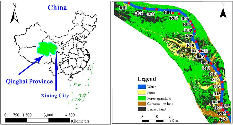
Figure 1. Distribution of sampling points in Beichuan River Basin.
In order to study the chemical characteristics of Beichuan River and the sources of its main ion components, 26 surface water samples were collected respectively in July 2019 (wet season) and October 2019 (dry season). At each site, water samples were collected from the midpoint of a bridge spanning the river using a polyethylene surface water sampler. The polyethylene sampling bottles were then triple-rinsed with the river water. Collection was typically performed below 50 cm from the water surface. Each sample was divided into two aliquots: one for the determination of cations (Na+, K+, Ca2+, and Mg2+), to which reagent-grade nitric acid was added on-site to acidify the solution to a pH < 2; the other for the determination of anions (HCO3−, SO42−, Cl−, NO3−), with no additives used. Ensure that all samples are filled with the entire container, refrigerated without bubbles and kept away from light. The sample analysis and testing were completed by the testing center of Institute of hydrogeology and environmental geology, Chinese Academy of Geological Sciences. All samples were tested within 1 week after collection. The pH was measured on site with a portable multi parameter water quality tester (HACH HQ40d, Loveland, CO, United States of America) and the detection limit values were 0.01 mg/L, the total dissolved solids (TDS) was measured by drying method, and the cations K+, Na+, Ca2+ and Mg2+ were measured by atomic absorption spectrophotometer (Agilent 7500ce, ICP-MS, Tokyo, Japan) and the detection limit values were 0.05 mg/L, 0.01 mg/L, 4.0 mg/L and 3.0 mg/L, respectively. Anions SO42−, Cl− and NO3− were determined by ion chromatography (Perkin ElmerLambda 35, Waltham, Ma, United States of America) and the detection limit values were 0.75 mg/L, 1.0 mg/L and 0.664 mg/L, respectively. HCO3− was determined by hydrochloric acid titration and the detection limit value was 5.0 mg/L.
In this study, ArcGIS 10.5 was used to draw the sampling points in the study area; Use Excel to calculate the mean and standard deviation of water sample test data; Origin 2022 was used to draw the ion ratio diagram and analyze the correlation of hydrochemical components (significance level 0.05); Finally, SPSS 25.0 was used to standardize the surface water data of Beichuan River Basin in wet and dry seasons, and then the Principal Component Analysis (PCA) of hydrochemical components was carried out.
PCA is an exceedingly effective method for dimensionality reduction within a dataset that encompasses a multitude of interrelated variables, aiming to preserve the maximal variability inherent in the data. Prior to integrating the data into the PCA model, the Kaiser-Meyer-Olkin (KMO) test and Bartlett’s test of sphericity were conducted to assess the suitability of the research data for PCA. In our study, we normalized the variables from the river water parameters dataset and conducted PCA to extract the most significant principal components, thereby diminishing the influence of less consequential variables. The components were then subjected to varimax rotation to simplify the interpretation of the results, transforming them into a set of orthogonal variables. Subsequently, we selected eigenvalues greater than 1 as the criteria for the new orthogonal variables. Drawing from established literature, factor loadings are categorized as “strong,” “moderate,” and “weak,” corresponding to absolute loading values of greater than 0.75, between 0.75 and 0.50, and between 0.50 and 0.30, respectively (Wang et al., 2023).
As can be seen from Table 1, the pH of the water body in the wet season ranges from 7.60 to 8.31, with an average of 8.08, while in the dry season it ranges from 7.82 to 8.32, averaging 8.17, indicating overall weakly alkaline water. The average value of TDS in wet season and dry season reached 224 mg/L and 236 mg/L respectively, exceeding the global average of 115 mg/L (Yang et al., 2021). This suggests that Beichuan River has a significant erosive effect on soluble salt rock. In the wet season and dry season, the order of the average concentration of cations in the water is: Ca2+>Na+>Mg2+>K+, mainly Ca2+, with an average mg equivalent percentage of 37.9%; The average concentration order of anions is: HCO3−>SO42−>Cl−>NO3−, in which the average mg equivalent percentage of HCO3− (68.7%) is higher than 50%, which is the main conducting anion.

Table 1. Chemical composition statistics of Beichuan river water.
It can be seen from Figure 2 and Table 1 that spatially, from the upstream to the downstream of the study area, the concentration of hydrochemical components shows a gradual increase trend, mainly due to the increase of mineral dissolution with the increase of runoff distance, combined with the increase of human activities in the middle and lower reaches of the basin, domestic sewage, agricultural fertilizer and other pollutants continue to flow into the river, resulting in the increase of ion concentrations. Among them, the concentrations of Na+, Mg2+, SO42−, Cl− and NO3− changed greatly in space, and their coefficient of variation reached 70.5%, 51.4%, 44.9%, 71.8%, 52.7% in wet season and 63.7%, 63.7%, 34.0%, 86.8%, 50.2% in dry season, respectively. The disparity observed is primarily attributed to the significant variations in human activity levels across the upstream (where the predominant land use is forest and grassland, with minimal human intervention), midstream (impacted by agricultural activities and domestic wastewater), and downstream (entering Xining city, heavily influenced by the intensity of human activities, particularly domestic sewage) regions of the study area. The time variation of hydrochemical components shows that the average concentrations of Na+, Cl− and NO3− in the wet season are higher than those in the dry season, which is mainly due to the increase of rainfall in the wet season, and the strong surface runoff is more likely to cause rock salt dissolution, thus causing the increase of Na+ and Cl⁻ concentrations (Ji et al., 2021). In addition, rainfall runoff will also bring more agricultural fertilizers to surface water, resulting in an increase in NO3− concentration (Jiang et al., 2022). The concentrations of K+, Ca2+, Mg2+, SO42−, HCO3−, and TDS in dry season were slightly higher than those in wet season, indicating that rainfall had a certain dilution effect on these components.
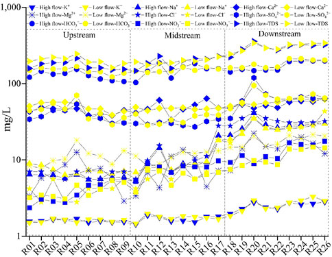
Figure 2. Spatial variation trend of main ion concentrations in surface water of Beichuan River.
Piper trilinear chart can reveal the concentration characteristics and hydrochemical types of cations and anions in water (Ji et al., 2021). Figure 3 indicates that the sampling points are mainly distributed in the lower left corner of the cation diagram and anion diagram, indicating that Ca2+and HCO3− are dominant in the water. During the wet season, the main hydrochemical type was HCO3−Ca water (50.0%), followed by HCO3−SO4−Ca water (26.9%), HCO3−Ca·Mg water (11.5%). The concentrations of Ca2+, Mg2+ and Na++K+ accounted for 64.0%, 19.7% and 16.4% of the total cations, respectively. The concentrations of HCO3−, SO42− and Cl− accounted for 64.7%, 24.0% and 11.3% of the total anions, respectively.
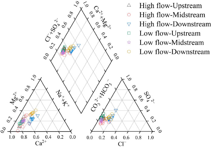
Figure 3. Piper diagram of main hydrochemical ions in surface water of Beichuan River.
In the dry season, Ca2+, HCO3− and SO42− dominated. The hydrochemical types included HCO3−Ca water (38.5%), HCO3·SO4−Ca water (23.1%), HCO3−Ca·Mg water (19.2%), HCO3−SO4−Ca·Mg water (19.2%) and HCO3−Ca·Mg water (19.2%). Ca2+, Mg2+and Na++K+ ions accounted for 61.2%, 24.8% and 14.0% of the total cations, respectively. HCO3−, SO42− and Cl⁻ ions accounted for 66.8%, 24.9% and 8.3% of the total anions, respectively.
Gibbs diagram is shown in Figure 4, which is often used to infer the hydrogeochemical process of natural water (Zilberbrand et al., 2001). The diagram is divided into three endmembers, namely evaporation concentration, rock weathering and atmospheric precipitation. The control area of atmospheric precipitation has low total dissolved solids concentration (<10 mg/L), high [Na+]/[Na++Ca2+] and Cl−/[Cl−+HCO3−] ratios, generally 0.5–1, which is distributed in the lower right corner of Gibbs diagram; The rock weathering zone is located in the middle of the left, and the TDS value is generally between 70 and 300 mg/L the ratio of [Na+]/[Na++Ca2+] and [Cl−]/[Cl−+ HCO3−] is generally less than 0.5; The evaporation concentration control area is in the upper right corner of the figure, which exhibits a high TDS (>300 mg/L), and the ratio of [Na+]/[ Na++Ca2+] and [Cl−]/[ Cl−+HCO3−] is also high (0.5∼1). The Beichuan River basin water sample points plotted on Gibbs diagram. It can be seen from Figure 5 that most water sample points in the wet season and dry season fall in the rock weathering control area, indicating that the surface water chemistry in the Beichuan River basin is mainly controlled by rock weathering. Furthermore, a few water sample points in the middle and lower reaches of the wet season move into the evaporation concentration area, indicating that evaporation concentration also has a certain impact on the hydrochemistry of the area.
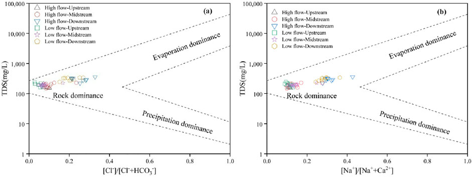
Figure 4. Gibbs diagram of Beichuan river surface water (a) TDS VS [Cl⁻]/[Cl⁻+ HCO3⁻] and (b) TDS VS [Na+]/[Na++Ca2+].
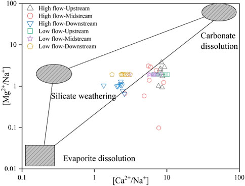
Figure 5. Relationship between [Ca2+]/[Na+] and [Mg2+]/[Na+].
The ratio-end member diagram is usually used to reveal the source of ions produced by chemical weathering in the basin (Zhai et al., 2024). As [Ca2+]/[Cl−] and [Mg2+]/[Na+] are not affected by flow rate, dilution and evaporation (Pant et al., 2017), the hydrochemical origin can be revealed according to the relationship between Ca2+/Na+ and Mg2+/Na+. Without the influence of human activities, Ca2+ and Mg2+ in the water environment are mainly from the weathering and dissolution of carbonate rocks and silicate rocks, Na+ and K+ are mainly from the weathering and dissolution of silicate rocks and rock salts, HCO3⁻ is mainly from the weathering and dissolution of carbonate rocks and silicate rocks, and SO42− and Cl− are mainly from the dissolution of evaporite rocks and rock salts (Niu et al., 2022). It can be seen from Figure 5 that the Beichuan River water sample is located in the middle of the silicate rock and carbonate rock weathering zone. The upstream and middle reaches of the study area are closer to the weathering area of carbonate rocks, whereas the downstream water sample points are closer to the weathering area of silicate rocks, indicating that the ion source of the upstream and middle reaches of the Beichuan River basin is mainly the weathering and dissolution of carbonate rocks, and the main ion source of the downstream sites is the weathering and dissolution of silicate rocks.
In order to further identify the source of chemical components of surface water in the study area, the [Na+]/[Cl−] map was used to identify the main sources of Na+ and Cl−. In aquatic environment, Na+ mainly comes from the dissolution of salt rock and silicate rock, and the dissolution of salt rock will release the same proportion of Na+ and Cl− (Fu et al., 2018). However, the concentration ratio of [Na+]/[Cl−] in the water samples of Beichuan River Basin during the wet season and dry season is between 1.17∼1.74 and 1.05∼4.71, respectively. Notably, the molar concentration of Na+ in the downstream of the basin is significantly higher than that of Cl⁻, which is far from the 1:1 line and close to the side of Na+ (Figure 6A), indicating that Na+ is not mainly from the dissolution of salt rocks, but may come from the dissolution of silicate rocks and the impact of human activities (sewage).
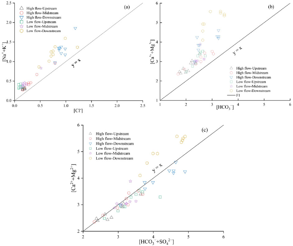
Figure 6. Relationship between Beichuan River [Na+]/[Cl−] and Cl− (A), [Ca2++Mg2+]/[HCO3−] (B) and [Ca2++Mg2+]/[HCO3−+SO42−] (C).
Ca2+ and Mg2+ in natural water mainly come from the dissolution of carbonate rock, silicate rock and evaporite, while HCO3⁻ mainly comes from the dissolution of carbonate rock and silicate, which is less affected by human activities. When it mainly comes from the dissolution of carbonate rocks, the relationship between [Ca2+ + Mg2+]/[HCO3−] should be 1:1. When evaporite rocks are involved in the dissolution, the relationship between [Ca2+ + Mg2+]/[HCO3−+SO42−] tends to be 1:1 (Wang et al., 2023). As shown in Figure 6B, the equivalent concentration ratio of [Ca2+ + Mg2+]/[HCO3−] at all water sample points in the wet season and dry season falls on the 1:1 line, indicating that Ca2+ and mg2+are not only derived from the dissolution of carbonate rocks, but also from the dissolution of silicate rocks. After SO42− is added (Figure 6C), most water samples fall near 1:1 of [Ca2+ + Mg2+]/[HCO3−+ SO42−] in the upstream and midstream of wet season and dry season, indicating that evaporite is involved in dissolution. In addition, the excess SO42− needs cations such as Na+ and K+ to balance, which further indicates the existence of silicate dissolution. In the lower reaches of the river during the dry season, most of the water samples are located above the 1:1 line, mainly because the groundwater is the primary supply source of the Beichuan River during the dry season, while the high concentration of Ca2+ and Mg2+ in the groundwater increases the concentration of Ca2+ and Mg2+in the river.
Human activities also have a very important impact on the concentration of chemical components in water environment, such as domestic and industrial sewage discharge, agricultural activities and so on, which will affect the concentration of chemical components in water environment (Zhang et al., 2023). Generally, in areas with strong human activities, the concentrations of NO3−, Cl−, SO42− and Na+ in surface water will increase significantly (Zhang et al., 2020). Previous studies have shown that SO42− in the water environment is mainly affected by industrial activities, while NO3−, Cl− and Na+ are affected by agricultural activities and domestic sewage (Zhang and Wang, 2020). Cl− ion is often used as an indicator of the source of water pollution because it is not affected by the physical, chemical and biological effects of water in the process of water environment migration, and the ratio of Cl− from different sources is different (Liu et al., 2006). Therefore, in this study, the ratio relationship between (NO3−/Cl−) and Cl−was used to determine the source of NO3− pollution in water (Yue et al., 2014). It can be seen from Figure 7A that the water sample points in the study area are mainly located near the two end elements of chemical fertilizer and sewage, indicating that NO3− in surface water is mainly from the input of chemical fertilizer and sewage. Among them, the land use in the upper reaches of the Beichuan River is mainly forest and grassland, and the land use in the middle reaches is mainly agricultural land and forest land. As shown in Figure 7A, the main source of NO3− in the upper and middle reaches of the Beichuan River is chemical fertilizer, and soil nitrogen also has a certain impact on nitrate in the water. However, in the lower reaches of Beichuan River, which flows through Xining city area, the discharge of domestic sewage from surrounding residents has an important impact on nitrate in water (Shu et al., 2024). As shown in Figure 7A, the downstream stations of Beichuan River are mainly located in the end element of sewage, indicating that sewage is the main source of nitrate pollution in the downstream waters of Beichuan River. In order to further identify the source of sulfate in water, the relationship between [NO3−/Ca2+] and [SO42−/Ca2+] was used to further characterize the impact of human activities on surface water. Among them, mining activities have higher [SO42−/Ca2+] value, while agricultural activities have higher [NO3−/Ca2+] value. As shown in Figure 7B, the Beichuan River has a high value of [SO42−/Ca2+] and a low value of [NO3−/Ca2+] at the upstream site. Due to the low sulfate concentration in the Beichuan River (the average value in wet season and dry season is 45.8 mg/L and 49.2 mg/L respectively), the upstream river of the Beichuan River may be affected by mining activities in the basin (such as gypsum plant), but the impact is small. The midstream and downstream stations have higher [NO3−/Ca2+] values, which are more inclined to agricultural activities and sewage.
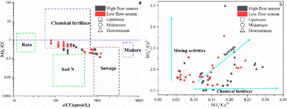
Figure 7. Relationship between [NO3−/Cl−] and Cl− (A) and [NO3−/Ca2+] and [SO42−/Ca2+] (B) of Beichuan River.
In this study, PCA employed to identify the pollution sources of Beichuan River in two hydrological periods. Nine water quality parameters (TDS, NO3−, K+, Na+, Ca2+, Mg2+, HCO3−, SO42− and Cl−) were selected for analysis. Prior to incorporating the data into the principal component analysis model, Kaiser Meyer Olkin and Barrett spherical tests were carried out on the research data. Results indicated that KMO values were 0.639 and 0.715 in the wet season and dry season, and the Barrett spherical test values were 484 (p < 0.001) and 513 (p < 0.001) respectively, indicating that the chemical data of Beichuan River water in the two hydrological periods met the requirements of principal component analysis. Based on an eigenvalue greater than 1, two main factors were identified in the two hydrological periods, which explained 89.9% and 91.8% of the information of all variables respectively (Table 2).
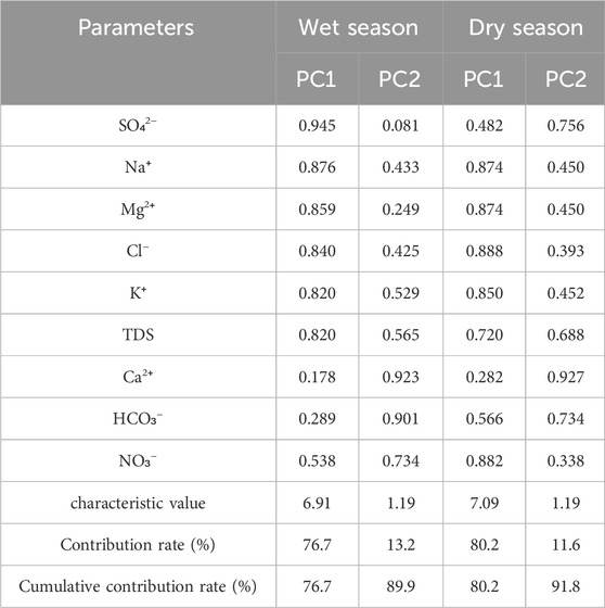
Table 2. Principal component analysis of main ions in surface water of Beichuan River.
It can be seen from Table 2 that primary component 1 (PC1) in the wet season explains 76.7% of the total variable (Figure 7). The indicators showing strong positive correlation with PC1 include SO42−, Na+, TDS, Mg2+, K+ and Cl−, and the indicator with medium positive correlation is NO3−. As the previous analysis shows, Na+, Mg2+ and Cl− in Beichuan River water are mainly from silicate dissolution, while SO42− is mainly from evaporite dissolution. Previous studies have found that nitrate in the water environment mainly comes from sewage, manure, fertilizer, rainwater, soil nitrogen, etc., (Zhang X. et al., 2024; Ren et al., 2024). The above analysis also shows that the nitrate in Beichuan River water mainly comes from sewage and chemical fertilizer. Considering the moderate positive correlation between NO3− and PC1, the nitrate in PC1 may come from chemical fertilizer. Therefore, PC1 represents that the hydrochemistry of Beichuan River is affected by rock weathering and agricultural runoff. Primary component 2 (PC2) explained 13.2% of the total variable information. The indicators with strong positive correlation with PC2 were Ca2+, HCO3− and NO3− and Na+ and Cl− also showed a moderate positive correlation with PC2. As the previous analysis shows, nitrate mainly comes from sewage and fertilizer. Since PC1 and PC2 are relatively independent, nitrate mainly comes from sewage. Previous studies have found that domestic sewage contains high concentrations of Na+ and Cl− (Zhang et al., 2020; Jiang et al., 2022). Therefore, PC2 represents that Beichuan River water chemistry is affected by domestic sewage.
In the dry season, PC1 explained 80.2% of the total variable (Figure 7). The indicators exhibited strong positive correlations with PC1 included Cl⁻, NO3−, Na+, Mg2+, K+ and TDS, and the indicator with medium positive correlation was HCO3⁻. The scarcity of rainfall in dry season makes it difficult for fertilizer in farmland to enter the river (Jiang et al., 2022). Consequently, PC1 represents that Beichuan River water chemistry is affected by domestic sewage. The indicators with strong positive correlation with PC2 were Ca2+, HCO3− and SO42−. Na+, Mg2+, K+ and TDS also demonstrated moderate positive correlation with PC2. Therefore, PC2 represents that Beichuan River water chemistry is affected by rock weathering.
The comprehensive analysis of the Beichuan River’s hydrochemical characteristics reveals a complex interaction between natural geological processes and human activities. The river’s chemistry is predominantly controlled by rock weathering, with human activities, especially in the downstream areas, exerting a significant influence. Seasonal variations are largely driven by rainfall, which affects the dissolution of rock salts and the transport of agricultural pollutants. The wet season sees a greater impact from agricultural activities, while domestic sewage becomes more prominent in the dry season. The study’s findings are crucial for understanding the hydrochemical dynamics in arid areas and have implications for the sustainable management of water resources. Future research should focus on the long-term effects of climate change and increasing human activities on the hydrochemical processes in this and similar arid environments.
The original contributions presented in the study are included in the article/supplementary material, further inquiries can be directed to the corresponding author.
XJ: Data curation, Investigation, Software, Writing–original draft. WL: Data curation, Investigation, Methodology, Software, Writing–original draft. ZJ: Investigation, Validation, Writing–review and editing. TZ: Conceptualization, Methodology, Resources, Supervision, Validation, Writing–review and editing.
The author(s) declare financial support was received for the research, authorship, and/or publication of this article. This work was supported by Open Foundation of the Key Laboratory of Coupling Process and Effect of Natural Resources Elements (No. 2024KFKT015), the Natural Science Foundation of China (Grant No. 42377232), Natural Science Foundation of Hebei Province of China (Grant No. D2022504015), and the Fundamental Research Funds for the Chinese Academy of Geological Sciences (No. YK202310). Hebei Central Government-Guided Local Science and Technology Development Fund Project (Grant No. 246Z3601G).
Authors XJ and ZJ were employed by Shaanxi Land Construction Group Co., Ltd.
The remaining authors declare that the research was conducted in the absence of any commercial or financial relationships that could be construed as a potential conflict of interest.
The handling editor HL declared a shared parent affiliation with the authors WL and TZ at the time of review.
All claims expressed in this article are solely those of the authors and do not necessarily represent those of their affiliated organizations, or those of the publisher, the editors and the reviewers. Any product that may be evaluated in this article, or claim that may be made by its manufacturer, is not guaranteed or endorsed by the publisher.
Chen, J. S., Wang, F. Y., and Xia, X. H. (2006). Geochemistry of water quality of the Yangtze River basin. Earth Sci. Front. 13 (1), 74–85.
Cui, T. K., and Zhang, D. D. (2017). Precipitation in Datonghe River Basin and assessment of surface and groundwater resources. China Water Resour. 3, 41–43.
Fu, C. C., Li, X. Q., Ma, J. F., Ling, X. L., Ming, G., and Zhan, X. B. (2018). A hydrochemistry and multi-isotopic study of groundwater origin and hydrochemical evolutionin the middle reaches of the Kuye River basin. Appl. Geochem. 98, 82–93. doi:10.1016/j.apgeochem.2018.08.030
Ji, X., Abakumov, E., Polyakov, V., and Xie, X. (2021). Mobilization of geochemical elements to surface water in the active layer of permafrost in the Russian Arctic. Water Resour. Res. 57 (1), 1–23. doi:10.1029/2020wr028269
Jia, H., Qu, W., Ren, W., and Qian, H. (2021). Impacts of chemical weathering and human perturbations on dissolved loads of the Wei River, the Yellow River catchment. J. Hydrol. 603, 126950. doi:10.1016/j.jhydrol.2021.126950
Jiang, H., Liu, W., Li, Y., Zhang, J., and Xu, Z. (2022). Multiple isotopes reveal a hydrology dominated control on the nitrogen cycling in the Nujiang River basin, the last undammed large river basin on the Tibetan Plateau. Environ. Sci. Technol. 56 (7), 4610–4619. doi:10.1021/acs.est.1c07102
Jiang, H., Zhang, Q., Liu, W., Zhang, J., Zhao, T., and Xu, Z. (2021). Climatic and anthropogenic driving forces of the nitrogen cycling in a subtropical river basin. Environ. Res. 194, 110721. doi:10.1016/j.envres.2021.110721
Kattan, Z. (2015). Chemical and isotopic characteristics of the Euphrates River water, Syria: factors controlling its geochemistry. Environ. Earth Sci. 73 (8), 4763–4778. doi:10.1007/s12665-014-3762-z
Liu, C., Li, S., Lang, Y., and Xiao, H. (2006). Using δ15N- and δ18O-values to identify nitrate sources in Karst ground water, Guiyang, Southwest China. Environ. Sci. Technol. 40 (22), 6928–6933. doi:10.1021/es0610129
Liu, S. T., Zhang, D., Li, Y. H., Yang, J. M., Jia, B. J., Wang, Y. T., et al. (2020). Water sources and factors controlling hydro-chemical compositions in the Yiluo River Basin. Environ. Sci. 41 (3), 1184–1196. doi:10.13227/j.hjkx.201908116
Maavara, T., Chen, Q., Van, M. K., Brown, L. E., Zhang, J., Ni, J., et al. (2020). River dam impacts on biogeochemical cycling. Nat. Rev. Earth Environ. 1, 103–116. doi:10.1038/s43017-019-0019-0
Moquet, J. S., Guyot, J. L., Crave, A., Viers, J., Filizola, N., Martinez, J. M., et al. (2016). Amazon River dissolved load: temporal dynamics and annual budget from the Andes to the ocean. Environ. Sci. Pollut. Res. 23 (12), 11405–11429. doi:10.1007/s11356-015-5503-6
Niu, C., Zhang, Q., Xiao, L., and Wang, H. (2022). Spatiotemporal variation in groundwater quality and source apportionment along the ye river of north China using the PMF model. Int. J. Environ. Res. Public Health 19 (3), 1779. doi:10.3390/ijerph19031779
Pant, R. R., Zhang, F., Rehman, F. U., Ramesh, R. P., Zhang, F., Faizan, U. R., et al. (2018). Spatiotemporal variations of hydrogeochemistry and its controlling factors in the gandaki River Basin, central himalaya Nepal. Sci. Total Environ. 622-623, 770–782. doi:10.1016/j.scitotenv.2017.12.063
Pant, R. R., Zhang, F. A., Rehman, F. U., Wang, G., Ye, M., Zeng, C., et al. (2017). Spatiotemporal variations of hydrogeochemistry and its controlling factors in the gandaki river basin, central himalaya Nepal. Sci. Total Environ. 622–623, 770–782. doi:10.1016/j.scitotenv.2017.12.063
Ren, X., Yue, F. J., Tang, J., Li, C., and Li, S. L. (2024). Nitrate transformation and source tracking of rivers draining into the Bohai Sea using a multi-tracer approach combined with an optimized Bayesian stable isotope mixing model. J. Hazard. Mater. 463, 132901. doi:10.1016/j.jhazmat.2023.132901
Shu, L., Chen, W., Liu, Y., Shang, X., Yang, Y., Dahlgren, R. A., et al. (2024). Riverine nitrate source identification combining δ15N/δ18O-NO3− with Δ17O-NO3− and a nitrification 15N-enrichment factor in a drinking water source region. Sci. Total Environ. 918, 170617. doi:10.1016/j.scitotenv.2024.170617
Tang, C. G., and Liu, C. Q. (2011). Characteristics and driving factors of surface water chemistry of Wujiang watershed. Environ. Earth Sci. 64 (5), 1445–1453. doi:10.1007/s12665-011-0968-1
Tang, X. Y. (2012). Preliminary analysis for chemical alternation index of riverbed sediments in Huangshui River. J. Salt Lake Res. 1, 20–23.
Wang, L., Zhang, Q. Q., and Wang, H. W. (2023). Rapid urbanization has changed the driving factors of groundwater chemical evolution in the large groundwater depression funnel area of northern China. Water 15, 2917. doi:10.3390/w15162917
Wang, X., He, K., and Dong, Z. (2019). Effects of climate change and human activities on runoff in the Beichuan River Basin in the northeastern Tibetan Plateau, China. Catena 176, 81–93. doi:10.1016/j.catena.2019.01.001
Xiao, L., Zhang, Q., Niu, C., and Wang, H. (2020). Spatiotemporal patterns in river water quality and pollution source apportionment in the arid Beichuan River basin of northwestern China using positive matrix factorization receptor modeling techniques. Int. J. Environ. Res. Public Health 17 (14), 5015. doi:10.3390/ijerph17145015
Xuan, Y. X., Tang, C. Y., Cao, Y. J., Tao, J., Kun, L. I., and Rui, L. I. (2018). Spatial and temporal variation of hydro-chemistry and chemical weathering characteristics in the Beijiang River Basin. Res. Environ. Sci. 31 (6), 1078–1087. doi:10.13198/j.issn.1001-6929.2018.03.19
Yang, J. Y., Yang, Y. H., Hu, Y. C., Feng, X. C., Zeng, K. K., and Wu, L. P. (2021). Hydrochemical characteristics and possible controls of the surface water in kashi River Basin, ili, xinjiang. Environ. Chem. 40 (12), 3815–3827. doi:10.7524/j.issn.0254-6108.2021042108
Yang, Zhu., Zhu, L., Liu, J., Zhang, Y., and Zhou, B. (2023). Influence of water conservancy project on runoff in the source region of the Yellow River and wetland changes in the Lakeside Zone, China. J. Groundw. Sci. Eng. 11 (4), 333–346. doi:10.26599/JGSE.2023.9280027
Yue, F. J., Liu, C. Q., Li, S. L., Zhao, Z. Q., Liu, X. L., Ding, H., et al. (2014). Analysis of δ15N and δ18O to identify nitrate sources and transformations in Songhua River, Northeast China. J. Hydrol. 519, 329–339. doi:10.1016/j.jhydrol.2014.07.026
Zhai, T. L., Zhang, Q. Q., Wang, L., and Wang, H. W. (2024). Temporal and spatial variations hydrochemical components and driving factors in Baiyangdian Lake in the Northern Plain of China. J. Groundw. Sci. Eng. 12, 293–308. doi:10.26599/jgse.2024.9280022
Zhang, Q., and Wang, H. (2020). Assessment of sources and transformation of nitrate in the alluvial-pluvial fan region of north China using a multi-isotope approach. J. Environ. Sci. 89, 9–22. doi:10.1016/j.jes.2019.09.021
Zhang, Q. Q., Wang, H. W., Liu, L., Zhai, T. L., and Zhang, X. Q. (2024). Multiple isotopes reveal the driving mechanism of high NO3– level and key processes of nitrogen cycling in the lower reaches of Yellow River. J. Environ. Sci. 138, 597–606. doi:10.1016/j.jes.2023.05.001
Zhang, Q. Q., Wang, H. W., Xu, Z. F., Li, G., Yang, M. N., and Liu, J. T. (2023). Quantitative identification of groundwater contamination sources by combining isotope tracer technique with PMF model in an arid area of northwestern China. J. Environ. Manage. 325, 116588. doi:10.1016/j.jenvman.2022.116588
Zhang, Q. Q., Wang, L., Wang, H. W., Zhu, X., and Wang, L. J. (2020). Spatio-temporal variation of groundwater quality and source apportionment using multivariate statistical techniques for the Hutuo River alluvial-pluvial fan, China. Int. J. Environ. Res. Public Health 17 (3), 1055. doi:10.3390/ijerph17031055
Zhang, W., Jin, X., Liu, D., Lang, C., and Shan, B. (2017). Temporal and spatial variation of nitrogen and phosphorus and eutrophication assessment for a typical arid river—fuyang River in northern China. J. Environ. Sci. 55, 41–48. doi:10.1016/j.jes.2016.07.004
Zhang, X., Wang, L., Miao, L., and Zhang, Q. (2024). Development and application of a comprehensive evaluation index system for groundwater quality evolution patterns. Environ. Res. 262, 119896. doi:10.1016/j.envres.2024.119896
Zhu, L., Liu, J. T., Yang, M. N., Liu, C. Y., Xie, F., and Li, B. (2022). Chemical characteristics and quality evaluation of groundwater in Beichuan River Basin in Qinghai Province. Bull. Soil Water Conserv. 42 (2), 235–241. doi:10.13961/j.cnki.stbctb.2022.02.032
Keywords: arid area, rivers, hydrochemistry, control factors, human activities
Citation: Jinbing X, Long W, Jie Z and Tianlun Z (2024) Hydrochemical variation characteristics and driving factors of surface water in arid Areas—a case study of Beichuan River in Northwest China. Front. Environ. Sci. 12:1493390. doi: 10.3389/fenvs.2024.1493390
Received: 09 September 2024; Accepted: 30 September 2024;
Published: 16 October 2024.
Edited by:
Hui Li, Chinese Academy of Geological Sciences, ChinaReviewed by:
Huiguo Sun, Chinese Academy of Sciences (CAS), ChinaCopyright © 2024 Jinbing, Long, Jie and Tianlun. This is an open-access article distributed under the terms of the Creative Commons Attribution License (CC BY). The use, distribution or reproduction in other forums is permitted, provided the original author(s) and the copyright owner(s) are credited and that the original publication in this journal is cited, in accordance with accepted academic practice. No use, distribution or reproduction is permitted which does not comply with these terms.
*Correspondence: Zhai Tianlun, MTE0NDY2MDc5QHFxLmNvbQ==
Disclaimer: All claims expressed in this article are solely those of the authors and do not necessarily represent those of their affiliated organizations, or those of the publisher, the editors and the reviewers. Any product that may be evaluated in this article or claim that may be made by its manufacturer is not guaranteed or endorsed by the publisher.
Research integrity at Frontiers
Learn more about the work of our research integrity team to safeguard the quality of each article we publish.