 Jin Wang*
 Jiarui Han
- School of Geography and Planning, China Regional Coordination and Rural Construction Institute, Sun Yat-sen University, Guangzhou, China
The formation of China’s territory has a long historical process. Prior research has highlighted the diverse historical development patterns across different regions. To delve deeper into the distinctiveness among regions and their nuanced disparities, the research centers on the settlements within Xinyi County, situated in the mountainous terrain of western Guangdong Province, China. The current study employs the research method of “Backward Observation” by conducting a literature review and utilizing ArcGIS for spatial analysis to investigate the spatial distribution and evolution process of regional settlements in western Guangdong. The results suggest a predominant involvement of the state in propelling the advancement of the indigenous community within Xinyi County, a progression primarily fulfilled by the conclusion of the late Qing and initial Republican eras, guided by the persistent localization and gentrification of migrating populations. Xinyi’s advancement pattern and speed exhibited notable distinctions from neighboring areas within Guangdong Province. This investigation additionally delves into G. William Skinner’s inquiries regarding the exceptional attributes and evolutionary patterns of localities, aligning with the South China School’s viewpoint on the varied nature of regional advancement procedures and cadences. This research on Xinyi’s historical evolution is importance in coordinating the preservation and advancement of historical towns, addressing urban-rural development disparities, and formulating future development strategies.
1 Introduction
The formation of China’s territory has a long historical process. It originates from the central plains as the political center, where Chinese thought continuously radiates towards surrounding tribes and political powers, leading to eventual mutual integration. The shifting settlement pattern reflects the territorial expansion of state authority, economic progress, and cultural amalgamation and encapsulates the region’s historical evolution (Körner, 2007; Lauer, 1993). American scholar G. William Skinner’s “Market System Theory” and “Macroregional Theory” have shaped scholarly investigations into China’s regional history and urban development. Liu Zhiwei and Chen Chunsheng have posited that distinct “regions” inherently follow unique developmental paths and possess internal operational mechanisms. Throughout history, the influence exerted by the state on different regions varied from one state to another, leading to diverse developmental trajectories across the country (Du and Bai, 2022). Although Skinner’s research found the unique characteristics and developmental cycles of the nine major regions in China and noted the differences in their developmental paces, it did not delve further into the internal differences within these regions.
The historical western Guangdong region has traditionally been considered a peripheral area in contrast to the central plain, which is closer to the power centers of the state and dynasties. Establishing state order and ideology has played a pivotal role in its evolution. A detailed examination of the development of settlements in western Guangdong can unveil the different historical rhythms of this region and provide insights into the manifestation of Chinese state ideology in various localities (Chen, 2021). In the “Southern China School,” the scholars integrated aspects of Skinner’s theories while critically evaluating their limitations. Noteworthy academics like David Faure, Chen Chunsheng, and Liu Zhiwei have conceptualized “region” as a dynamic entity and conducted analyses on the intricate web of regional interactions. Through exploring the histories of Guangdong, Fujian, and Hong Kong, they have illuminated the process of local societies assimilating into the central dynasties, particularly highlighting the significant social advancements during the Ming Dynasty and the subsequent diffusion during the Qing Dynasty (Faure and Li, 2016). While research predominantly concentrates on central and eastern Guangdong, the western region remains relatively understudied (Chen, 2021; Faure and Bu, 2009). Notably, the development pace and operational mechanisms of western Guangdong, along with its distinctions from other parts of the province, warrant further investigation.
This study delves into Xinyi in western Guangdong, China, employing the “Backward Observation” (Zhao, 2018) method to reconstruct the synchronic spatial configuration of settlements as a diachronic historical narrative of settlement evolution. There are research records on attempts to elucidate how ancient state governance deepened in western Guangdong to create a solid social order. Furthermore, it focuses on the resultant transformations in local social dynamics and settlement patterns. Exploring western Guangdong’s settlement development is essential for the region’s holistic historical urban preservation to minimize urban-rural developmental disparities and represent a remarkable blueprint for devising sustainable development strategies.
2 Materials and methods
2.1 Study area
Historically, Xinyi encompasses the Gaoliang region, the day Maoming City in the Guangdong Province, China (Figure 1). Positioned on the border between Guangdong and Guangxi in the western region of Guangdong, Xinyi boasts a landscape characterized by abundant mountains, dense forests, and meandering rivers and streams. Predominantly mountainous, the terrain exhibits higher elevations in the eastern sector and lower elevations towards the west. Intermediate mountains distinguish the eastern portion, while the western area comprises low mountains and hills (Meybeck et al., 2001). In the Jianjiang River Basin, Xinyi County is geographically separated from the Xijiang River Basin by the Yunkai Mountains. The convergence of the East River (Jinjiang River or Dongzhen River) and the West River (Beijie River) within Xinyi forms the Jianjiang River, which has historically served as a vital waterway for transportation. Historically, Xinyi faced limited external connectivity due to challenging transportation routes. Initially inhabited by ethnic minorities, the region experienced the integration of Han Chinese settlers, significantly influencing settlement development. The term “settlement” refers to the most basic residential unit and serves as the fundamental unit of this study. The “county” represents a higher administrative level and denotes a regional concept. The “city” specifically refers to a central area within the region that holds higher political and economic functions. This study focuses on 1597 settlements in the western section of Xinyi City, located within the transitional zone between mountains and plains. It explores the impact of advancements in national governance within the mountainous region of western Guangdong on the evolution of settlements and overall regional development in Xinyi.
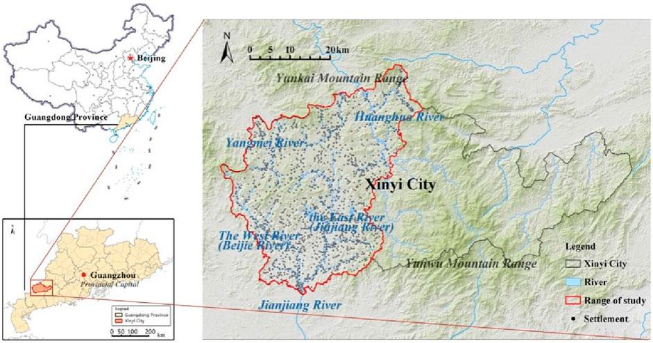
Figure 1. Location and study area in Xinyi City, Guangdong Province, China. (Created by the author).
2.2 Data
The dataset utilized in this research is predominantly categorized into historical documents and geospatial data. The historical documents encompass a range of editions of local chronicles such as the Gaozhou Prefecture (“高州府志”) (Cao, 2007; Wang and Yu, 2007; Yang and Chen, 2007; Ye and Huang, 2007) and Xinyi County (“信宜县志”) (Ao et al., 2007; Li and Li, 2007; Liu and Li, 2007; Xinyi County Local Chronicles Compilation, 1993; Zhou, et al., 2007). Geospatial data comprises DEM terrain data with a resolution of 12.5 m from ASF Data Search, hydrographic data sourced from Open Street Map, and historical administrative division data provided by the China Historical Geographic Information System (CHGIS V4). Additionally, settlement information was sourced from the “Xinyi City Volume of the Guangdong Villages Chorography,” (Guangdong Provincial Government Local Chronicles Office, 2021) yielding 1597 effective natural village data points within the designated study area.
2.3 Methods
This study employs the “Backward Observation” approach to scientifically and objectively analyze the historical evolution of settlements in Xinyi County. The so-called “Backward Observation” is to take the structural elements observed in one’s field point, which are still alive, and push them back to the historical starting point for which they have material evidence, and then, from this starting point, narrate these structural elements one by one to a later time, and finally summarise the structural process of the history of the region (Zhao, 2018). Following this approach and considering the specific context of the study area, the three research steps used in the study include:
Step 1:. Collation of historical literature and field investigation data. This aspect involves systematically collecting and analyzing materials from provincial, prefectural, and county gazetteers and other relevant local histories and official records to gather basic cultural and historical spatial information for the study area, emphasizing the impact of specific periods, events, or themes on the region. The collected historical documents and field survey data are then organized chronologically and compiled into an Excel database to form a comprehensive spatial-temporal information repository (Tuan, 1977; Tuan, 1990).
Step 2:. Construction of a geographic database of historical settlements in Xinyi County (Blanco et al., 2019). Utilizing satellite maps and ArcGIS, the database contains coordinates (latitude and longitude) of topography, water systems, administrative divisions, prefectural and county seats, market towns, natural villages, and historical buildings. Following the logic of “backward tracing,” spatial information such as topography, water systems, administrative boundaries, prefectural and county seats, and settlements are reconstructed for various historical periods, moving from the present to the past.
Step 3:. Combining quantitative and qualitative analysis methods. First, based on the database in Step 2, spatial analyses were conducted using ArcGIS to calculate the kernel density index of the distribution of settlements and polders, the distance between settlements and water sources, and topographic changes to study the macro-distribution characteristics of settlements (Chainey et al., 2008; Sabel et al., 2005; Silverman, 2018). The formula for the kernel density analysis method is as follows:
The equation represents the density estimate at the position, the number of observations, the smoothing parameter, the kernel function, and the distance from the position to the observation position.
Data visualization techniques in ArcGIS and Excel were utilized to quantify the relationships between settlement distribution and natural geographic and historical-cultural factors. Furthermore, qualitative methods such as comparative studies and descriptive analysis are employed based on the spatial analysis and data visualization to transform the synchronic spatial structure of the settlements into a diachronic historical process, thereby revealing the driving mechanisms behind the spatial evolution of settlements in Xinyi County (Whitehand, 1977; Whitehand, 2019).
3 Manuscript formatting
3.1 Evolution of Xinyi settlements: Historical transformations and social transition processes
3.1.1 Before the Yuan dynasty (before 1206): Nominal control, reclaiming and cultivating fields
Before the Yuan Dynasty (1206), the Xinyi region was administratively part of Guangxi, sharing a close geographical connection. The establishment of Liangde County and Liangde Prefecture under Longzhou’s rule during the Liang Dynasty (502) marked the region’s early administrative history, with the area being renamed Huaide County in the subsequent Sui Dynasty (598). A governance system known as “Jimi” was introduced in the Liang Dynasty to manage the Gaoliang region by appointing minority ethnic leaders as administrators to assimilate local chieftains into the governing structure. Han official Feng, by marrying into the Gaoliang Li ethnic group Xian, effectively controlled the Gaoliang region (Bai, 2009) (p. 332) and established the Feng family village settlement within the old county (Today’s Old Town Village, Changpo Town, Gaozhou) (Li, 2006) (p. 13).
The Tang Dynasty later divided Feng’s domain, instituting a formal district and county administrative setup between 646 and 693 (Liu, 2009) (Figure 2), creating Douzhou to oversee Huaide, Xinyi, Tan’e, and Teliang counties under the Western Lingnan Road jurisdiction (Yang and Chen, 2007) (pp. 25–26) (Figure 3). Administrative enhancements during the Song Dynasty resulted in the consolidation of Huaide, Tan E, and Teliang into Xinyi County within Guangnan West Circuit, featuring a fortified earth wall strategically positioned at a convergence point of two rivers, controlling key transportation pathways (Cao, 2007) (p. 15).
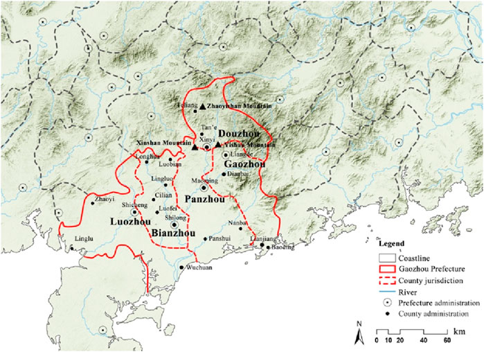
Figure 2. Administrative Divisions in Gaoliang Region during the Tang Dynasty (646). (Created by the author).
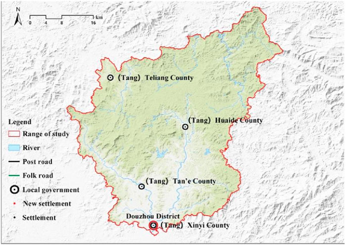
Figure 3. County Seats in Douzhou during the Tang Dynasty (634). (Created by the author).
Preceding the Yuan Dynasty (1206), Xinyi was geographically isolated and faced harsh natural conditions, resulting in its peripheral location along postal routes (Yan, 1996). Owing to rugged terrain and security risks from bandits, governmental authority over Xinyi was relatively feeble, with low productivity and economic development. Scarce data impedes accurate reconstruction of settlement patterns, with ethnic minorities primarily inhabiting mountainous regions and practicing agriculture at foothills and ridges, referred to as “cultivating food with the Luotian fields” (Wu, 1993). The establishment of Han Chinese settlements was in its initial stages. Overall, the administrative nodes in Xinyi during this period were mainly symbolic political controls, reflecting the initial penetration and control by the state administrative authority in minority-inhabited areas. Despite geographical constraints, a rudimentary administrative framework centered around county towns gradually took shape in Xinyi.
3.1.2 Yuan and Ming periods (1206–1644): organizing households, settlements sprouting
During the Yuan Dynasty (1206–1434), Xinyi was within the Gaozhou Prefecture, a part of the Haibei Hainan Circuit in the Huguang Province. The Yuan dynasty, a dynasty founded by ethnic minorities that ruled for a relatively short period, nevertheless had a profound impact on China’s geopolitical system. The Yuan rulers expanded their influence towards the south, seeking to assimilate the southern frontier areas into the imperial administrative framework. This territorial expansion facilitated the reconfiguration of the national territory and administrative hierarchy, establishing the groundwork for subsequent dynasties. The Yuan Dynasty constructed a new post road in western Guangdong to bolster military efforts against Champa and Jiaozhi and enhance overseas trade and commodity transport between Guangzhou, Gaozhou, and Leizhou (Yan, 1996). This road linked Guangzhou to Zhaoqing, and then directly to Gaozhou and Leizhou through Nan’enzhou, significantly promoting social and economic ties between the Pearl River Delta region and western Guangdong, aiding regional development during the Ming Dynasty.
In the early Ming Dynasty (1396), Zhu Yuanzhang reassigned Gaozhou Prefecture from Guangxi to Guangdong Province (Liu and Lian, 1988) (p.406), with Xinyi County falling under the jurisdiction of Gaozhou Prefecture in Guangdong (Ao et al., 2007) (p. 324). The county office was established on the former site of the Tang Dynasty’s Xinyi County city, now known as Zhenglong Town. Xinyi City was a pivotal transportation hub connecting western Guangdong’s mountainous and plain regions. Moreover, the imperial court implemented a comprehensive policy of military campaigns and pacification efforts towards ethnic minorities in western Guangdong, resulting in the submission of Yao tribal leaders to the central government and fostering a relatively stable social environment. In this context, individuals from diverse ethnic backgrounds engaged in productive endeavors in the Xinyi region, leading to the emergence of Han Chinese settlements.
During the initial period of the Ming Dynasty (1368–1435), the settlements dispersed across mountainous terrains and plains. Typically, Mountainous settlements were along gentle slopes, foothills, and mountain crests. At the same time, those in the plains clustered primarily around Xinyi County. Encouraged by land reclamation initiatives, certain clans relocated for sanctuary or followed the military into the mountainous regions of Xinyi, establishing scattered settlements (Figure 4). Although the distribution of minority villages remains uncertain, historical texts suggest that the Yao and Hakka communities inhabited the mountains, while Han individuals who migrated alongside the army predominantly dwelled in the plains. The restricted dimensions of Xinyi County have resulted in its limited sphere of influence, thereby failing to establish a distinct central force capable of driving regional advancement. There are no records of the numerous local inhabitants and refugees residing in the mountainous regions of Xinyi in the national census. During this era, settlements were relatively diminutive in size, indicative of their early phase of organic expansion.
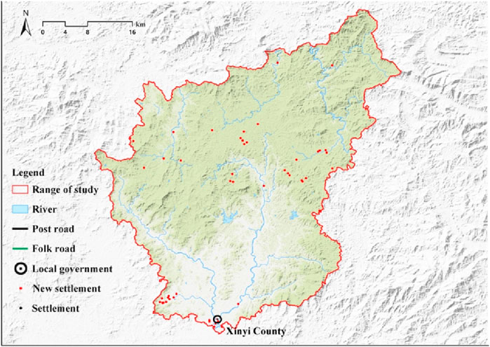
Figure 4. Settlement Distribution in Xinyi County from the Yuan Dynasty to the Early Ming Dynasty (1206–1434). (Created by the author).
Transitioning to the middle to late Ming Dynasty (1436–1644), a considerable influx of refugees sought shelter in the mountains and forests as regional advancement unfolded. Owing to the mounting pressure on the living spaces of ethnic minorities in these areas, the Yao uprisings became a recurring occurrence. The Ming government executed various administrative and military reforms to address these upheavals. Following the relocation of Gaozhou Prefecture’s administration, direct connectivity was established with the mountainous expanse of western Guangdong via the Jianjiang River watercourse, heightening the strategic importance of the former Xinyi county town (Zhang et al., 2007) (pp. 332–335) (Figure 5).
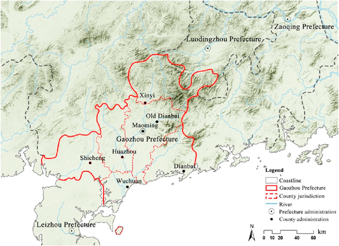
Figure 5. County Seats in the Mid to Late Ming Dynasty in Gaozhou Prefecture (1436–1644). (Created by the author).
Consequently, the Ming government fortified the old Xinyi county town’s defense infrastructure and military capabilities to bolster authority over the Xinyi region (Xinyi County Local Chronicles Compilation, 1993) (pp. 332–335). Simultaneously, the Yao Rebellion and its subsequent quelling facilitated significant cultural exchanges between mountainous communities and the governing authorities. Figures like Cheng Wende, representing governmental authority, undertook educational initiatives amidst the unrest and subsequent pacification efforts, striving to propagate Han Chinese cultural customs and ceremonial rituals to the local populace (Ao et al., 2007) (p. 67, p. 80). Nonetheless, the transient nature of the positive impact of educational development could be attributed to the lack of endorsement from local elites (Li and Li, 2007) (p. 77).
The reorganization of transportation and administrative divisions in the Ming Dynasty profoundly impacted the societal progress of Xinyi County. After the Luo Pang Expedition in 1576 during the Wanli era, the government introduced new county towns (Ying, 2015) and post roads (Zhao and Zhong, 2007) (p. 74–76) in western Guangdong to bolster regional connectivity and oversight, thus fostering the advancement of commercial trade in the area. Xinyi, the first military and political hub after leaving the mountainous region in western Guangdong along the post road, experienced a shift in its status (Figure 6). This transformation was further accentuated by the implementation of the “granting land and establishing households registration” policy (Xinyi County Local Chronicles Compilation, 1993) (p. 14), which enticed a considerable influx of Han Chinese settlers to Xinyi (Ao et al., 2007) (p. 417). By the Chongzhen period (1628–1644), notable gentry families began to settle in Xinyi (Li and Li, 2007; Zhou, et al., 2007) (pp. 491–515), paving the way for the ascendancy of local gentry during the Qing Dynasty and the enhancement of national governance. The ensuing rise in population led to the proliferation of villages on river plains and the emergence of market towns, resulting in a settlement pattern characterized by market towns lining the riverbanks and villages clustered around military and administrative centers.
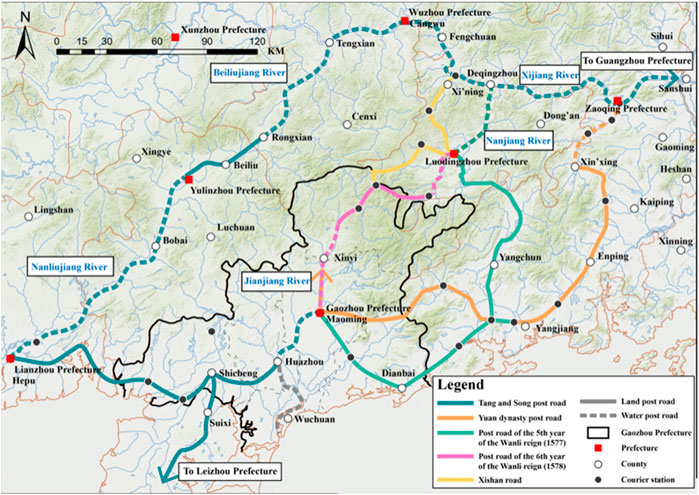
Figure 6. Direction of the Western Guangdong Post Road (1435–1644). (Created by the author).
The findings from the kernel density analysis of Ming Dynasty settlements underscore that the positioning of administrative nodes and the development of transportation routes played a pivotal role in shaping settlement patterns during that era. Settlements predominantly sprouted around stable and easily reachable administrative or military nodes like Xinyi County town and Huaixiang, with no conspicuous clustering observed around market towns. Furthermore, a notable surge in settlements in mountainous regions near the Zhusha River indicated that population migration routes and natural topographical features also influenced settlement distributions (Figure 7).
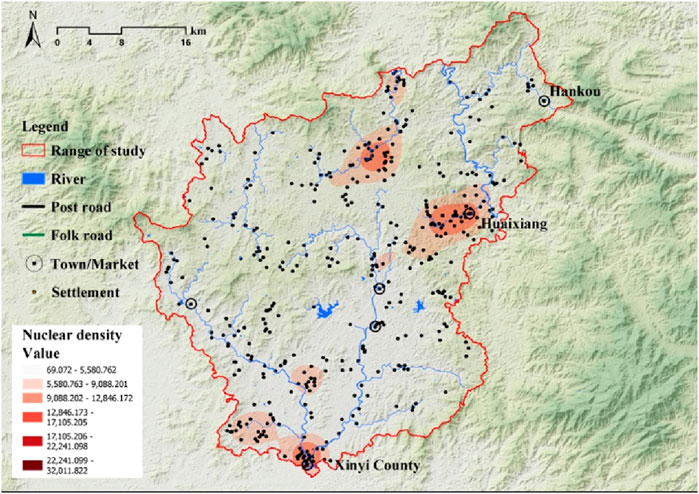
Figure 7. Kernel Density Analysis of Settlements in the Late Ming Dynasty (1435–1644). (Created by the author).
3.1.3 Qing Dynasty (1644–1875): the post road improved, settlements expanded
During the Qing Dynasty, the administrative organization of Gaozhou Prefecture demonstrated a trend toward stability following a period of upheaval and disorder. Despite uprisings among the Yao people and farmers, the foundation of the dynasty’s governance remained intact (Li and Li, 2007) (p.14). In 1656, during the 13th year of Shunzhi’s reign, Governor Xu Mingpei restored the city wall destroyed in the conflict (Li and Li, 2007) (p.417). These restoration efforts received support from the local government to encourage eco-initiatives nomic activities, such as land reclamation, water conservation projects, and tax reductions (Ao et al., 2007) (p. 417). These endeavors facilitated the gradual recovery of war-affected lands, attracting a significant influx of immigrants from regions like Fujian, Zhejiang, Jiangxi, Hunan, eastern Guangdong, northern Guangdong, and Gaozhou, leading to population growth in Xinyi County (Figure 8).
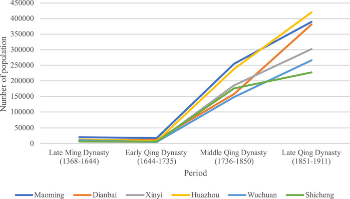
Figure 8. Population Trends of Counties in High Prefecture during the Ming and Qing Dynasties (1368–1911) (Compiled by the author from the local chronicles of Xinyi County, Maoming County, Dianbai County, Huazhou District, Shicheng County and Wuchuan County).
During the Qing Dynasty, the advancement of Xinyi culture and education exhibited a stable progression. Notably, a discernible shift in the perspective of the gentry class towards educational pursuits emerged when contrasted with the Ming Dynasty.
Since the Qing Dynasty, the presence of the scholar-gentry community facilitated the establishment of local academies in Xinyi. Noteworthy officials such as Governor Xu Mingpei and Luo Shiyi have effectively overseen initiatives to foster cultural and educational development (Ao et al., 2007) (p.385). Alongside the robust expansion of official educational institutions, there has been a notable enhancement in both the quantity and caliber of local academies (Ao et al., 2007) (pp. 385–387, pp. 394–395). While some academies established by officials have been either abandoned or remodeled over time, the substantial rise in the number of local academies in Xinyi during the Kangxi period (1662–1722) also indicates a shift in the local literary style.
Xinyi County and Huaixiang grew up as pivotal administrative and transportation hubs during this era, fostering a stable social environment and efficient transportation networks. This conducive setting spurred the expansion of surrounding settlements, particularly in riverside locations boasting favorable conditions for agriculture and trade. As a result, numerous villages sprang up, forming a settlement pattern with Xinyi County town and Huaixiang town at its core, supported by commercial market towns and river transportation networks (Figure 9).
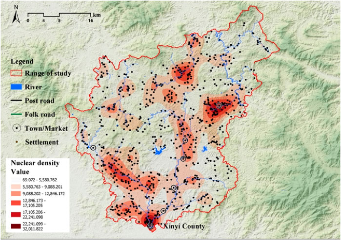
Figure 9. Kernel Density Analysis of Settlements during the Early Qing Dynasty (1644–1735). (Created by the author).
During the initial year of the Qianlong Emperor’s reign in 1736, the western Guangdong region experienced a notable enhancement in transportation infrastructure by establishing the Gaobei Ridge passage and advancing the Jianjiang River water system, which led to the bolstering of economic ties between the region and its neighboring areas, prompting the inhabitants of Guangdong to engage in land reclamation efforts actively (Hao, 2006). According to documentary records, Xinyi’s population experienced an exceptionally rapid increase, surpassing natural growth rates (Yang and Chen, 2007). The surge is attributable to the significant influx of migrants during the Qianlong period, along with the waves of emigration from Guangdong and the migration routes (Ge et al., 1993). As a significant influx of immigrants settled in, the communities along the East River and the West River in Xinyi witnessed rapid expansion, ushering in a prosperous era of commercial activities (Wang and Yu, 2007) (p.433). The evolution of transportation systems reshaped the spatial configuration of settlements in Xinyi County, transitioning from a layout centered around the county town to one focused on commercial market towns connected by transport networks (Figure 10). Notably, the distribution of settlements in terms of topography, environmental conditions, and proximity to rivers did not exhibit substantial deviations from previous patterns, indicating a historical continuity in local population growth and settlement trends dating back to the Qing dynasties (Figure 11). Waterborne transport and market towns continued as pivotal nodes linking settlements within the traditional rural settlement framework.
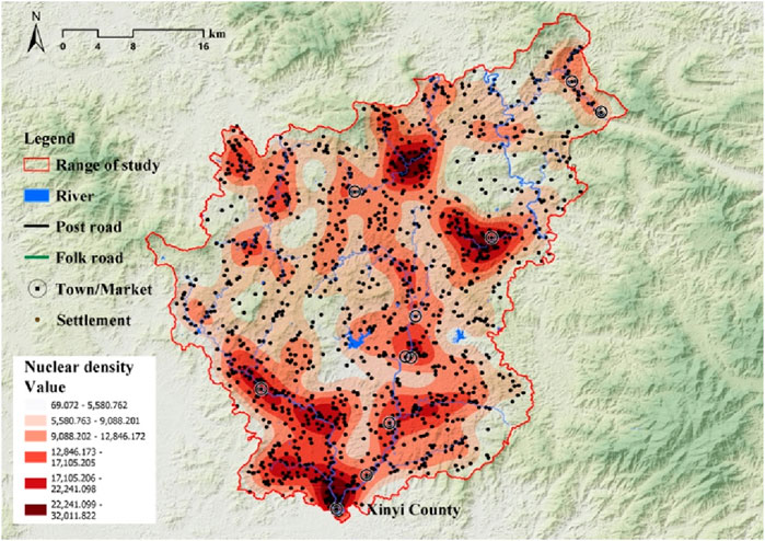
Figure 10. Kernel Density Analysis of Settlements during the Mid-Late Qing Dynasty (1736–1875). (Created by the author).
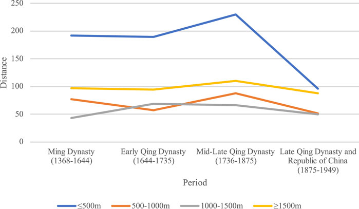
Figure 11. Changes in the Number of Settlements at Various Distances from Water Sources in Xinyi County During Different Historical Periods. (Created by the author).
Throughout the middle and later periods of the Qing Dynasty (1736–1911), significant transformations unfolded in Xinyi’s local society due to advancements in regional transportation and population expansion. Facilitated by the gentry class, elements of Ancient Chinese Central Plains culture and national customs gradually permeated the mountainous regions of Xinyi, fostering the amalgamation of the Han and Yao ethnic groups. By the era of Qianlong (1711–1799), ethnic minorities in Xinyi had predominantly assimilated into Han culture, assuming roles as taxpayers and laborers, thereby contributing to social order stability (Ye and Huang, 2007) (p. 137). Simultaneously, the domain of imperial examination education flourished in Xinyi, with a substantial increase in the number of tribute students. Several individuals from Xinyi even attained the prestigious Jinshi status while the local elite class progressively expanded. Local officials and the local gentry’s emphasis on and support for education have led to the thriving development of the educational sector. A significant number of town residents collectively donate public funds to support students participating in the imperial examinations (Ao et al., 2007) (pp. 398–400) and they also actively contribute funds to and participate in cultural development initiatives (Ye and Huang, 2007) (p. 128).
During the Xiantong period (1851–1875), banditry frequently occurred (Gao Lei Travel Hong Kong Compatriot Association, 1985) (p. 3). With their authority gained through imperial examination achievements, the gentry actively maintained social order. It took on responsibilities for public affairs management. They constructed a political image as a bridge of communication between the people and the government (Ao et al., 2007) (pp. 489–515), promoting social stability and community prosperity. In conclusion, the local gentry in Xinyi was essential in advancing national governance and maintaining social stability, providing substantial support for social development.
3.1.4 Late qing to republic of China (1876–1949): flourishing trade, regional development completed
After the Qing Dynasty (1876–1911), a notable equilibrium in the distribution of markets across various counties occurred in the western Guangdong region. The economic model has transitioned from a single-center structure focused on Gaozhou prefecture of the plain hinterland to a multi-center structure in the coastal areas. Noteworthy trade hubs such as Meicun, Zhiliao, Liangjiatan, Bohe, and Liantou in Wuchuan County, Shicheng County, and Dianbai County along the Gaozhou Prefecture coast played a pivotal role as essential trade centers with active foreign trade engagements. The utilization of the Jianjiang River system facilitated the export of inland goods, contributing to a concentrated economic activity along the coastal plains and increased foreign trade interactions (Chen, 2019; Li, 2019). This trend indicates that the Gaozhou Prefecture region had completed essential development by the end of the Qing dynasty and actively promoted economic development in coastal areas.
During the late Qing Dynasty (1876–1911), Xinyi had close connections with its surrounding areas as transportation networks improved. The frequent trade activities along the coastal area of Gaozhou Prefecture (Figure 12) stimulated the prosperity of the markets and settlements along the river in Xinyi (Figure 13). For example, the Zhenglong market in Xinyi County town flourished with the convenient transportation conditions under the leadership of the peasant uprising leader Chen Jingang, giving rise to various new business models in the late Qing period (Ruan and Chen, 1999) (p. 462), making it one of the most prosperous commercial centers in Xinyi. The growth of commercial activities and the development of family economies strengthened the network of settlements centered around marketplaces (Ao et al., 2007) (p. 358), driving the transformation of the entire regional economy and the expansion of settlements.
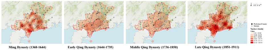
Figure 12. Kernel Density Analysis of Market Towns in Gaozhou Prefecture during the Ming and Qing Dynasties (1368–1911). (Created by the author).
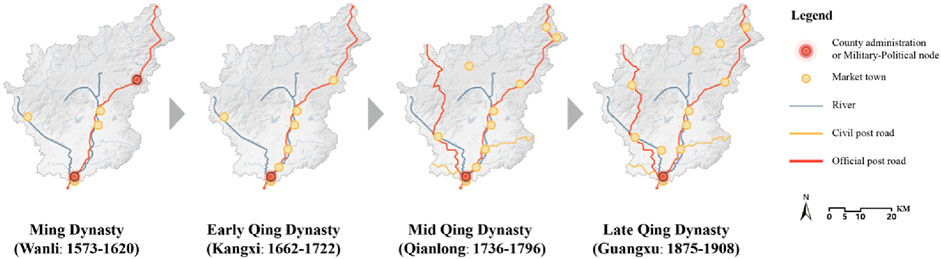
Figure 13. Number and distribution of Market Towns in Xinyi County during the Ming and Qing Dynasties. (Created by the author).
During the Guangxu era (1875–1908), a combination of natural calamities and societal unrest catalyzed the influx of foreign investments and the export of labor overseas, ushering in novel business prospects for Xinyi. Prominent figures like Chen Mingpan, Lin Shouzhen, and Li Jilian actively participated in international trade (Ruan and Chen, 1999) (pp. 507–508), propelling the swift advancement of local commerce and industry. Consequently, the regional economy embarked on a trajectory towards modernization. The affluent class and ancestral families took the lead in erecting ancestral shrines and educational institutions, fostering educational progression within the community and enhancing social governance (Figure 14). Notably, during times of societal turmoil, family schools in Xinyi played a pivotal role in disseminating contemporary cultural teachings and revolutionary ideologies, nurturing a cadre of emerging intellectuals, and steering societal metamorphosis.
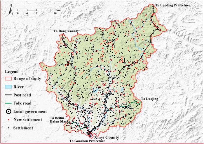
Figure 14. Distribution of Ancestral Halls and Schools in Xinyi County during the Late Qing Dynasty and the Republic of China (1876–1949). (Created by the author).
Throughout this period, the expansion rate of settlements in Xinyi decelerated. Newly formed settlements predominantly emerged in flatlands and low-lying hilly terrains, with the vicinity surrounding the market town emerging as the epicenter of developmental activities. This evolution gave rise to an economic network centralized around the market town (Figure 15). The southern plains and plateaus have high population densities, creating a radial spatial structure centered around the old county town of Xinyi. The assorted market towns functioned as pivotal junctions linking rural districts and integrating the entire region.
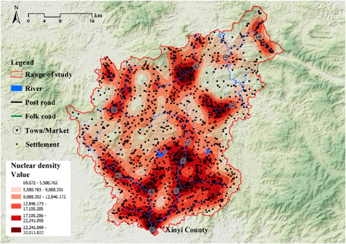
Figure 15. Kernel Density Analysis of Settlements during the Late Qing Dynasty and the Republic of China (1876–1949). (Created by the author).
In summary, the development of the Xinyi region occurred during the late Qing Dynasty to the early Republic of China period. During this period, Xinyi County flourished in trade, boasted a well-established transportation infrastructure, and underwent a modernization metamorphosis in regional economic dynamics, education, and social and cultural frameworks.
3.2 National governance and the evolution of Xinyi settlements
Various factors, including the geographical landscape, demographic composition, governmental strategies, and policies, accelerated the progressive expansion of settlements in Xinyi. The settlement evolution could be delineated into five discernible stages: foothill valley control stage, natural scattering stage in the mountains, aggregation around military and administrative points stage, expansion along river routes and post roads stage, and deep penetration into the interior of the plains stage (Table 1).
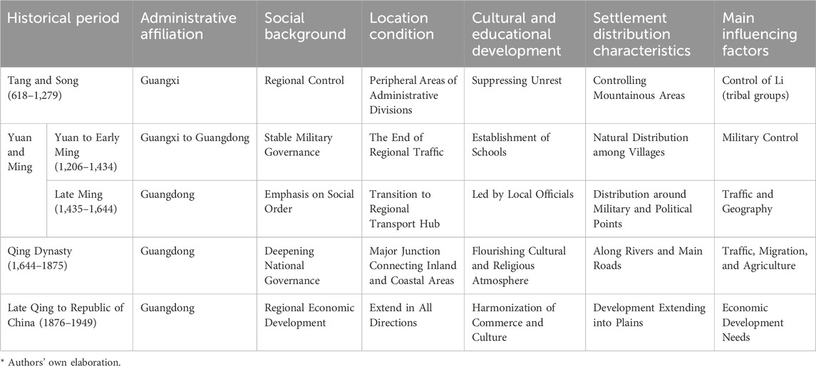
Table 1. Features of National Governance and Settlement Evolution in Xinyi County. (Created by the author.)
Throughout the Tang and Song dynasties, minority ethnic groups in Xinyi predominantly inhabited foothills and mountainous regions, while governmental and military installations denoting state authority were established at the entrances of mountain valleys. Owing to its remote location at the terminus of regional transport networks and limited interaction with the Central Plains, state influence was restricted, resulting in delayed economic progress. The government’s persistent development efforts in western Guangdong facilitated the establishment of a direct postal route linking Yangjiang and Gaozhou prefectures, catalyzing the emergence of Han Chinese settlements in Xinyi.
Following the Luo Pang Expedition in the Wanli era, the newly established post road and Xishan Road directly linked Guangzhou Prefecture with the Xinyi Mountainous Area, prompting an influx of Han Chinese migrants who encroached upon the living spaces of minority groups in the mountains. During regional advancement, this demographic shift reshaped state-local region relationships. The incoming Han Chinese settlers primarily clustered around government-controlled administrative centers. In the Qing Dynasty, enhancements in waterway transportation along the Jianjiang River and the Luoxin post road, coupled with local policies encouraging land reclamation, facilitated a renewed influx of Han Chinese immigrants into Xinyi.
The proliferation of Han Chinese settlements along the riverbank plains progressively intensified, fostering the establishment and flourishing of market towns. Throughout the Ming and Qing dynasties, the plains flanking the East and West Rivers in Xinyi underwent extensive development, witnessing a notable rise in settlement density. By the conclusion of the Qing Dynasty and the early Republic of China period, substantial progress had been made in the regional development of Xinyi. The evolution of urban-rural settlements in this area underscores the interconnected relationship between national governance and local community growth.
3.3 Evolutionary patterns of settlement layout
When examining the structure and transformations of the Chinese national system, Xu Zhuoyun has delineated two critical aspects of this progression: one pertains to external expansion, denoting spatial enlargement; the other concerns internal enrichment, signifying the enhancement within the system (Lu, 2010). The development of the Xinyi settlement pattern similarly embodies these dual facets. More specifically, the evolutionary trajectory of the Xinyi settlement pattern has traversed five distinctive stages (Figure 16). The concept of “external expansion” is exemplified by the “leap” during the Tang and Song Dynasties, as well as the “radiation” in the Yuan and Ming Dynasties. From the mid to late Ming Dynasty through the Republic of China era, the spatial manifestations characterized by the “axial,” “continuous,” and “filling” stages epitomize the process of “internal enrichment.”
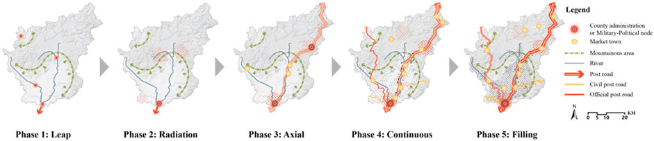
Figure 16. Settlement Evolution Pattern in Xinyi County. (Created by the author).
3.3.1 Leap
During the Tang and Song dynasties, the sparsely populated mountainous regions of western Guangdong were primarily inhabited by ethnic minorities, with settlements dispersed throughout the area. Geographical factors and the uneven distribution of resources constrained the growth of these settlements. County towns were strategically founded in pivotal locations within the landscape, leading to a fragmented spatial arrangement. Ethnic minority communities tended to establish settlements in locales rich in resources, such as foothills and mountain inclines.
3.3.2 Radiation
During the Yuan and Ming dynasties, the spatial organization of settlements demonstrated a discernible central-peripheral configuration. Counties and towns in the lowlands served as the focal point, while rural villages were dispersed in the mountainous areas. The growth of these settlements was predominantly dependent on the appeal and outreach of Xinyi County. However, owing to its constrained scope and impact, Xinyi County has yet to evolve into a prominent hub propelling regional progress.
3.3.3 Axial
Due to improved transportation conditions in the middle to late Ming period, external immigrants began to enter the Xinyi area. The expansion of settlements was guided by transport routes, gathering along the axis towards military and political nodes at both ends, showing a trend of interconnected belt-like patterns between nodes.
3.3.4 Continuous
During the Qing Dynasty, there was a notable surge in the proliferation of settlements and market towns due to a steady influx of migrants from various regions. These immigrants actively cultivated previously untamed lands alongside the river, causing the once scattered settlements to meld together into a unified expanse with the assistance of efficient water and land transportation networks. Concurrently, the dominance of military and political hubs began to wane, leading to a gradual erosion of boundaries between the settlements.
3.3.5 Filling
By the late Qing and early Republic of China period, regional development was nearing completion. Empty spaces within the riverine plains were gradually filled with new settlements, resulting in a noticeable difference in settlement density between the plains and mountainous areas.
3.4 Driving factors for the development of Xinyi settlements
The evolution process of the settlements in Xinyi is a complex historical process. The evolution of settlements in Xinyi is similar to that in central and eastern Guangdong. The central driver of local social development is the ‘state.’ The gentrification of immigrants is the main driving force behind the deepening of state governance and the prosperity of settlements. Local societies have experienced local development, dynastic “enlightenment,” re-establishment of order shifts in power structures during the social upheaval, and modern social transformation (Chen, 2021). Under the unified national mechanism framework, the development of Xinyi settlements and the social changes in Guangdong’s central and eastern regions show a consistent pattern. However, specific temporal and spatial differences are also due to different resource endowments.
Many studies believe that the regional spatial structure of historical settlements is influenced by a combination of natural factors such as topography, climate, hydrology and human factors such as population, regional culture, and institutional environment (Wang, et al., 2012). In the evolution of Xinyi’s settlement, the roles and impacts of natural and human factors vary. In the early stages of development, geographical constraints and inefficient transportation systems limited growth, and the government’s influence was minimal. It was not until the Yuan and Ming dynasties, with the establishment of stagecoach routes, that state power began to extend into western Guangdong, leading to a significant increase in the number of settlements. The process of local gentrification, however, did not commence until the Ming and Qing dynasties (1616–1683), which consequently delayed the implementation of local development and civilization efforts. In the late Qing Dynasty, the local society in Xinyi also relied on the crucial intermediary role of the gentry class and intellectuals to complete the complex process of regional social transformation and integration into unified China, achieving prosperity in commerce, and completing regional development (Liu, et al., 2019).
4 Conclusions and discussion
By analyzing the historical evolution of settlements in Xinyi County, this study confirms that regional development processes and rhythms exhibit diversity. While G. William Skinner’s regional model holds significant value for understanding the spatial structure of Chinese history, its treatment of regions as static entities fails to fully capture the dynamic evolution of different areas over time. Building on Skinner’s theory, the South China School further deepened regional research based on the realities of China. It demonstrated the diverse regionalexperiences and developmental trajectories in China’s historical evolution. The research results indicate that the Xinyi region achieved substantial governance deepening and settlement prosperity by the late Qing and early Republican periods, with a historical development rhythm distinct from other areas of Guangdong Province. Its spatial evolution was not a simple, linear process but resulted from overlapping and interacting forces, including state governance, local gentry activities, and natural environmental factors.
Xinyi County’s historical development exhibited a relative lag, contrasting with the commonly perceived notion of the Lingnan region as having an overall more advanced historical trajectory. Specifically, the settlement patterns in Xinyi remained dispersed and small-scale for an extended period, significantly lagging behind the development of areas such as the Pearl River Delta and eastern Guangdong during the same time frame. As a unique subregion within Lingnan, western Guangdong followed a distinct developmental path. This fact highlights that the Lingnan region was not entirely homogeneous, with different localities experiencing distinct historical processes and development rhythms. Due to its later development, western Guangdong remains one of the less developed regions within Guangdong Province today.
Nevertheless, the region’s historical development stages share similarities with the processes observed in central and eastern Guangdong. Thus, future planning efforts for western Guangdong could potentially draw upon the developmental experiences of similar regions. Researching the evolution and driving forces behind Xinyi’s settlements aims to delve into the historical narratives and planning patterns of traditional communities in western Guangdong, offering valuable insights for present and future urban-rural development initiatives in the region.
Data availability statement
The original contributions presented in the study are included in the article/supplementary material, further inquiries can be directed to the corresponding author.
Author contributions
JW: Writing–review and editing. JH: Writing–original draft.
Funding
The author(s) declare that no financial support was received for the research, authorship, and/or publication of this article. This research received no external funding.
Acknowledgments
The authors thank the reviewers for their constructive comments on improving this research.
Conflict of interest
The authors declare that the research was conducted in the absence of any commercial or financial relationships that could be construed as a potential conflict of interest.
Publisher’s note
All claims expressed in this article are solely those of the authors and do not necessarily represent those of their affiliated organizations, or those of the publisher, the editors and the reviewers. Any product that may be evaluated in this article, or claim that may be made by its manufacturer, is not guaranteed or endorsed by the publisher.
References
Ao, S., Liang, A., and Li, Z. (2007). (Guangxu) Xinyi county gazetteer. Guangxu 17th year (1889) edition. Guangzhou: Lingnan Art Publishing House.
Bai, X. (2009). Complete works of lady xian culture, volume 1. Guangzhou: Sun Yat-sen University Press.
Blanco, A., De Bustamante, I., and Pascual-Aguilar, J. A. (2019). Using old cartography for the inventory of a forgotten heritage: the hydraulic heritage of the Community of Madrid. Sci. Total Environ. 665, 314–328. doi:10.1016/j.scitotenv.2019.02.133
Cao, Z. (2007). (Wanli) Gaozhou prefecture gazetteer. Wanli period edition, Guangdong provincial local history office collection, compilation of historical gazetteers of Guangdong, Gaozhou prefecture section. Guangzhou: Lingnan Art Publishing House.
Chainey, S., Tompson, L., and Uhlig, S. (2008). The utility of hotspot mapping for predicting spatial patterns of crime. Secur. J. 21, 4–28. doi:10.1057/palgrave.sj.8350066
Chen, L. (2019). Zhanjiang port and the maritime silk road. Guangzhou, China: Guangdong Economic Publishing House.
Du, S., and Bai, A. (2022). On the inheritance and transcendence of skinner's regional theoryby south China research. J. Humanit. 7, 1–11. doi:10.15895/j.cnki.rwzz.2022.07.001
Faure, D., and Bu, Y. (2009). Emperors and ancestors: the state and clan in south China. Nanjing: Jiangsu People's Publishing House.
Faure, D., and Li, Z. (2016). Society and ritual in the ming and qing dynasties. Beijing, China: Beijing Normal University Press.
Ge, J., Cao, S., and Wu, S. (1993). Immigration history of China. Fuzhou: Fujian People's Publishing House.
Guangdong Provincial Government Local Chronicles Office (2021). Complete Guangdong village records: maoming city, Xinyi city volume. Guangzhou: South China University of Technology Press.
Hao, Y. (2006). (Yongzheng) Guangdong general gazetteer. Qing yongzheng 9th year edition. Guangzhou: Lingnan Art Publishing House.
Körner, C. (2007). The use of “altitude” in ecological research. Trends Ecol. and Evol. 22 (11), 569–574. doi:10.1016/j.tree.2007.09.006
Lauer, W. (1993). Human development and environment in the Andes: a geoecological overview. Mt. Res. Dev. 13, 157–166. doi:10.2307/3673633
Li, A. (2019). Maoming port and the maritime silk road. Guangzhou, China: Guangdong Economic Publishing House.
Li, L., and Li, T. (2007). (Kangxi) Xinyi county gazetteer. Kangxi 13th year (1674) edition, Guangdong provincial local history office collection, compilation of historical gazetteers of Guangdong, Gaozhou prefecture section. Guangzhou: Lingnan Art Publishing House.
Liu, D., and Lian, M. (1988). Excerpts of Guangdong minority materials from the ming shilu. Guangzhou: Guangdong People's Publishing House.
Liu, F., Zhu, X., Li, J., Sun, J., and Huang, Q. (2019). Progress of gentrification research in China: a bibliometric review. Sustainability 11 (2), 367. doi:10.3390/su11020367
Liu, Q., and Li, D. (2007). (Qianlong) Xinyi county gazetteer. Qianlong 21st year (1756) edition. Guangzhou: Lingnan Art Publishing House.
Liu, Y. (2009). On Gaoliang (高凉) area' s transformation from jimi (羁糜) prefecture to norma prefecture in early Tang dynasty: a case study of Feng family (冯氏) in Gaoliang area. China's Borderl. Hist. Geogr. Stud. 19 (01), 67–72.
Lu, X. (2010). The historical process, features, and significance of southern mountainous area development. Review of Chinese economic and social history, 49–88.
Meybeck, M., Green, P., and Vörösmarty, C. (2001). A new typology for mountains and other relief classes. Mt. Res. Dev. 21 (1), 34–45. doi:10.1659/0276-4741(2001)021[0034:antfma]2.0.co;2
Sabel, C. E., Kingham, S., Nicholson, A., and Bartie, P. (2005). Road traffic accident simulation modelling-a kernel estimation approach, 67–75.
Silverman, B. W. (2018). Density estimation for statistics and data analysis. London, United Kingdom: Routledge.
Tuan, Y. (1977). Space and place: the perspective of experience. Minneapolis, MN: University of Minnesota Press.
Tuan, Y. (1990). Topophilia: a study of environmental perception, attitudes, and values. Columbia University Press.
Wang, G., and Yu, D. (2007). (Qianlong) Gaozhou prefecture gazetteer. Qianlong 24th year (1759) edition, Guangdong provincial local history office collection, compilation of historical gazetteers of Guangdong. Guangzhou: Lingnan Art Publishing House.
Wang, X., He, X., Ge, J., and Gong, S. (2012). Review on literature of historical settlement geography in China. Trop. Geogr. 32 (01), 107–112.
Whitehand, J. (2019). Green space in urban morphology: a historico-geographical approach. Urban Morphol. 23 (1), 5–17. doi:10.51347/jum.v23i1.4077
Whitehand, J. W. R. (1977). The basis for an historico-geographical theory of urban form. Trans. Inst. Br. Geogr. 2, 400–416. doi:10.2307/621839
Wu, Y. (1993). Overview of Yao society during the ming dynasty. J. South-Central Univ. Natl. 5, 44–49.
Xinyi County Local Chronicles Compilation (1993). Xinyi county gazetteer. Guangzhou: Guangdong People's Publishing House.
Yan, G. (1996). Examination of postal routes and stations in western Guangdong during the yuan dynasty. China's Borderl. Hist. Geogr. Stud. 1, 24–32.
Yang, J., and Chen, L. (2007). (Guangxu) Gaozhou prefecture gazetteer. Guangxu 16th year (1890) edition, Guangdong provincial local history office collection, compilation of historical gazetteers of Guangdong. Guangzhou: Lingnan Art Publishing House.
Ye, S., and Huang, A. (2007). (Daoguang) Gaozhou prefecture gazetteer. Qing daoguang 7th year (1827) edition, Guangdong provincial local history office collection, compilation of historical gazetteers of Guangdong, Gaozhou prefecture section. Guangzhou: Lingnan Art Publishing House.
Ying, J. (2015). Gazetteer of the cangwu governor-general's office. Changsha, China: Yuelu Book Company.
Zhang, H., Wang, S., Shao, Y., and Cui, Y. (2007). (Daoguang) Dianbai county gazetteer. Daoguang 5th year (1825) edition, Guangdong provincial local history office collection, compilation of historical gazetteers of Guangdong. Guangzhou: Lingnan Art Publishing House.
Zhao, S. (2018). Structuring, ritual marker and backward observation from Now Three keywords in the study of historical anthropology in China. J. Tsinghua Univ. Philosophy Soc. Sci. 33 (01), 1–11. doi:10.13613/j.cnki.qhdz.002703
Zhao, Z., and Zhong, G. (2007). (Kangxi) xining county gazetteer. Kangxi 6th year (1667) edition. Guangzhou: Lingnan Art Publishing House.
Keywords: western Guangdong, settlement evolution, driving mechanisms, Xinyi, planning history
Citation: Wang J and Han J (2024) The historical evolution and social transformation of settlements in the mountainous regions of western Guangdong: a case study of Xinyi County, China. Front. Environ. Sci. 12:1469164. doi: 10.3389/fenvs.2024.1469164
Received: 27 July 2024; Accepted: 03 October 2024;
Published: 15 October 2024.
Edited by:
Stephen A. Kowalewski, University of Georgia, United StatesReviewed by:
George Pomeroy, Shippensburg University, United StatesGregory Veeck, Western Michigan University, United States
Copyright © 2024 Wang and Han. This is an open-access article distributed under the terms of the Creative Commons Attribution License (CC BY). The use, distribution or reproduction in other forums is permitted, provided the original author(s) and the copyright owner(s) are credited and that the original publication in this journal is cited, in accordance with accepted academic practice. No use, distribution or reproduction is permitted which does not comply with these terms.
*Correspondence: Jin Wang, d2FuZ2ozODZAbWFpbC5zeXN1LmVkdS5jbg==