- 1Department of Road and Bridge Engineering, Guizhou Communication Polytechnic University, Guiyang, Guizhou, China
- 2Laboratory for Mountain-Area Highway Safety and Vehicle-Road Collaboration Research, Guizhou Engineering Research Centers for Mountain-Area Expressway Intelligence Operation and Maintenance, Guiyang, Guizhou, China
- 3School of Resources and Safety Engineering, Central South University, Changsha, Hunan, China
Water is an important strategic resource for sustainable development and a basic element for ecological environment construction, especially in the karst areas of southwest China. Based on the concept model of drive, pressure, engineering water shortage, status, ecological foundation, and response (DPESFR), we built a comprehensive assessment indicator system based on the characteristics of karst water resources. The entropy-weighted right, CRITIC, and analytic hierarchy process methods were used to determine three types of basic weights, and the coordinated weights of all indicators were obtained by combining the thought method of game theory. The matter–element analysis model was then used to calculate the water resource safety situation of Guiyang from 2013 to 2022, and the limiting factors were explored using the limiting degree model. Finally, the autoregressive integrated moving average (ARIMA) model was used to predict water resource safety of Guiyang from 2023 to 2030. The results of these analyses were as follows: (1) the integral situation of the water resource safety in Guiyang showed an annual downward trend. The water resource safety was found to be grade IV from 2013 to 2017 and grade III from 2017 to 2022; from 2023 to 2030, the integral water resource safety grade is expected to continue decreasing, with the integral level expected to remain at grade III. (2) In six subsystems of the criterion layer, the key limiting factors affecting the water resource safety of Guiyang were the “state” subsystem, followed by the “response” and “drive” subsystems, with the indicators under different subsystems being different. (3) The most influential factors limiting the degree were concentrated in the “state” subsystem, followed by the “response” subsystem, indicating that both human activities and natural conditions significantly impact water resource safety in Guiyang. By identifying and analyzing the indicators affecting water resource safety in Guiyang, it is seen that measures such as controlling the total amount of industrial wastewater discharge, improving the treatment rates of domestic sewage, ensuring ecological water usage, and promoting water-saving technologies are important prerequisites for ensuring water resource safety in Guiyang.
Highlights
• An improved concept model was constructed in this study.
• A matter–element analysis model was used to calculate water resource safety of Guiyang from 2013 to 2022.
• Limiting factors were explored using the limiting degree model.
• An autoregressive integrated moving average (ARIMA) model was used to predict water resource safety of Guiyang from 2023 to 2030.
1 Introduction
Water is one of the main sources of life as well as the foundation of production, the basis of ecology, and the strategic and primary natural resource needed for social sustainability (Wu et al., 2023a; Sahin et al., 2017). The rapid economic and population growths, along with excessive development and utilization of water resources, have resulted in frequent floods and drought disasters, serious ecological degradation, and water pollution, because of which water resource safety has become the most pressing and immediate resource constraint for sustainable development of mankind in the 21st century. Statistically speaking, of 657 cities in China, more than 300 cities are classified as “severely water-stressed” or “water-stressed” under the assessment criteria of the United Nations Habitat and Environment Program (Peng and Qin, 2019). Alakbar and Burgan (2024) adopted a regional power duration curve model for ungauged intermittent river basins. Accordingly, water resource security assessment plays a vital part in planning water resource strategies and guaranteeing socioeconomic sustainability.
Water resource safety assessment is a key problem of water resource safety studies and is elemental to implementing water resource safety strategies; hence, it is a popular topic of study (Deng et al., 2023; Zhao et al., 2024). The core problem of water resource safety assessment is whether the water resources of a nation or region can satisfy the demands of long-term and sustainable development of society. Through safety assessments of water resources, the influences of numerous factors on regional water resource safety are analyzed systematically, and the current safety situation is assessed, which forms the basis of sustainability and management of water resources; these also form the premise of related engineering planning, design, and operation management (Dai et al., 2015). Wu et al. (2023b) studied the water resource vulnerability of an arid inland river basin. Liu et al. (2021) assessed the sustainability of water resources in a karst area based on the emergy ecological footprint model and analyzed its driving factors. It can be concluded from the above literature analyses that all these investigations on water resource safety are about non-karst areas and that there are nearly no available studies on karst areas with special geological environments. Meanwhile, water resource safety in a karst area varies with different stages, objectives, and conditions with respect to water resource development and utilization. Thus, there is an urgent need to study water resource safety conditions in karst areas as they constitute about one-third of the land area of China.
Research on water resource safety assessments is of great significance. Based on a review of the existing common indicators of water resource safety assessment and by combining relevant characteristics of the study areas, the present work builds a basic index database and establishes an assessment indicator system for water resource safety in karst regions (Wang et al., 2024). We considered Guiyang as an example and carried out an integrated assessment of water resource safety with the aim of accurately evaluating the situation. Thus, we expect to provide relevant decision-support strategies for water resource safety in karst regions (Deng et al., 2022; Zamri et al., 2023).
2 Assessment indicators for water resource safety
2.1 Basic index database for water resource safety assessments
Studies on water resource safety in China started at the turn of the century when an indicator system was built; these indicators can generally be divided into two categories as follows. First, on the basis of water resource safety, the indicators were divided into multiple sub-security systems, such as economic, water supply, and ecological security; then, appropriate indicators were selected from each subsystem. Second, based on the overall water resources, the indexes were selected to build the evaluation system.
Deng et al. (2022) built an assessment indicator system from four sub-security systems, namely, the supply supports, exploitation, distribution, and utilization of water resources, by taking Chongqing city as the case study to assess the status quo of water resource safety. Wu et al. (2023a) built a water resource safety assessment system based on the physical endowment conditions of the water resources, social coordination system, economic coordination system, and ecological environment and food security system; they also used the fuzzy matter–element, limiting degree, and autoregressive integrated moving average (ARIMA) models to evaluate water resource safety in Lanzhou from 2005 to 2030. Based on the assessment indicator system of water resource safety, Jacques (2022) used a dialectical water–man interaction model to conduct a quantitative and comprehensive study on the temporal changes in water resource safety. Based on the concepts of production, life, and ecology, Zhang et al. (2023) established an integrated assessment indicator system using the pressure–state–response (PSR) model and combined the entropy-weighted model with TOPSIS to assess the regional water ecological security; they then used the synthetic index to evaluate the composite index of water ecological safety levels in the three-dimensional space, analyzed its spatial–temporal evolution, and used the GM(1,1) model to forecast the water ecological security level in Anhui from 2022 to 2026. Wang et al. (2023) constructed a water resource safety assessment system for the Yangtze River Economic Zone using the entropy method and analytic hierarchy process (AHP) and comprehensively analyzed its water resource safety situation from 2007 to 2016.
In addition, some scholars have established direct evaluation systems using the overall water resource safety. On the basis of the PSR model, Yao et al. (2019) constructed an assessment indicator system for water resource safety in Guizhou Province at three levels: water requirement stress, water resource state, and human social interactions; they then used the multitarget rough subordinate function normalization and comprehensive index methods to assess the water resource safety state of Guizhou from 2001 to 2015. Jemmali (2017) used the improved multidimensional index of water poverty, which is composed of human economic welfare and physical amounts of water available, to analyze the extent to which water resource shortage affected African people. Wang et al. (2019) analyzed the status of Taizhou city’s water situation, followed the assessment indicator system construction principles, and built a water circumstance safety indicator system containing socioeconomic indicators, water-quality guidelines, water content indicators, and water ecological indexes. The authors chose 22 indicators and used AHP to allot weights to these indicators; then, they used the synthetic indicator method to assess the water environmental safety of Taizhou city. Furthermore, some other scholars have assessed water resource safety using water resource stress, which is the most representative indicator of water resource in per capita terms, along with water resource exploitation and utilization levels and the water poverty index (WPI). Among these, the WPI was proposed by the British hydrologist Sullivan (2002), and Chinese scholars such as Deng and Li (2023) have used this method to assess water resource safety. Water resource safety is a global problem with high complexity. The WPI model includes factors such as economic status, water resource quality, population quality, and ecological environment. It can link water resource safety assessment with social development status to better reflect the state of social water resources, but there are still shortcomings in reflecting the overall situation. For example, its calculation and data collection processes are complicated and cumbersome, and the qualitative descriptions require consultation of expert opinions. In addition, the calculation basis of each sectorial index varies from one region to another; therefore, it is important to select applicable variates to formulate the computational framework of the WPI (Chen et al., 2023; Qin et al., 2023a).
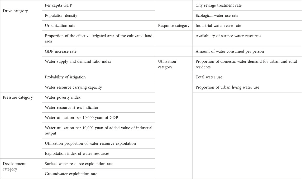
To summarize, water resource safety assessment indicators can be divided into five categories, namely, drive, pressure, development, response, and utilization. Furthermore, several widely used indicators are needed to obtain the basic index database constituting the assessment indicator system of water resource safety, as shown in Table 1.
2.2 Establishment of an indicator system for water resource safety in karst areas
The core principle of establishing an indicator system is to account for the scientificity and simplicity. Scientificity requires that the index system reflect the evaluated object as comprehensively and accurately as possible, while simplicity requires that the selected index data are easy to obtain, calculate, operate, and apply. Scientificity and simplicity often contradict each other (Li et al., 2022). If people only pursue scientificity and ignore simplicity, the established index system may lose its application value because the data are difficult to obtain. Contrarily, if people pay too much attention to simplicity and ignore scientificity, then the established index body cannot reflect the true status of the assessment object, although given its simplicity, and may hence lose its application value. Therefore, a practical and reasonable index system must be the best combination of scientificity and simplicity (Peng et al., 2021; Peng et al., 2023).
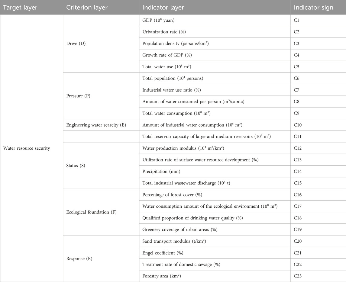
Water resource safety entails many elements, including dynamic, static, qualitative, and quantitative indicators. On the basis of the connotations for water resource safety in karst areas, we classified the water safety assessment system into the target, criterion, and index layers by referring to relevant research results and taking the above principles into consideration (Wang et al., 2021; Peng and Deng, 2020a). The target layer is a single focus, namely, water resource safety, which expresses the comprehensive security degree of water resources. The purpose of the water resource safety assessment is to comprehensively evaluate the level of regional water resource safety and implement water management measures according to the evaluation results to promote harmonious coexistence among humans, water, the sustainable, healthy development of society and the economy. The criterion layer is an organic part of the target layer that combines relevant research results on water resource safety; accordingly, this layer includes supply supports, exploitation, distribution, and utilization of water resources. The selection of assessment indicators adheres to scientific, holistic, practical, representative, and regional principles and fully reflects the overall situation of socioeconomic development of water resource safety in the evaluation region (Peng and Deng, 2020b).
By referring to previous studies (Peng and Deng, 2020b), we adopted an indicator system based on the drive (D), pressure (P), engineering water shortage (E), status (S), ecological foundation (F), and response (R) (i.e., DPESFR) concept model in a special karst area that has the characteristics of fast conversion of three types of water resources, namely, prominent water scarcity in engineering, inefficient industrial and agricultural water usage, and other water shortages (Peng et al., 2023). The DPESFR concept model includes six parts, as shown in Table 2, using specific indicators.
2.3 Calculation model
2.3.1 Determination of basic weights
The entropy-weighted right and CRITIC methods are objective weighting methods, of which the entropy-weighted right method determines weights based on the quantity of information offered by the observed values of each index (Lu et al., 2023). As an objective weighting method, the CRITIC method considers the changeability of an index and correlations between the indicators; it then uses objective attributes of the data to determine the weights (Wu et al., 2023a). The analytic hierarchy process in systems engineering theory resolves the subjective weights of the indicators based on their contributions to the evaluation results (Ma et al., 2024). The basic weights of each of the indexes obtained using the abovementioned three methods are designated as Wa, Wb, and Wc.
2.3.2 Deciding the coordination weights
The coordination weight obtained by optimizing the weight coefficient based on game theory reflects not only the subjective intention of the decider but also the objectivity of the evaluation data (Peng and Deng, 2020a). The basic idea here is to seek uniformity or compromise among the diverse base weights and determine the most satisfactory coordinating weights by minimizing the respective deviations between the coordinating weights and each base weight. The computational procedures are as follows.
(1) Arbitrary combination of L fundamental weight vectors WK
In Equation 1, W is a possible weight according to the basic weight set and is the result of the cross fusion of the basic weights; αk is the linear coefficient of the combination; and WKT is the vector of base weights.
(2) The L linear coefficients αk of the combination are upgraded to minimize the deviations between W and each WK (Miao et al., 2024) such that
In Equation 2, Wi is the index weight obtained using the three weighting methods.
(3) Calculation of the coordination weight coefficients αk*
In Equation 3, the coordination weight coefficients αk
* could be obtained from the linear combination coefficients
(4) Calculation of the coordination weights W*
In Equation 4, the coordination weight W* can be obtained based on results of αk* and WKT calculated from Equations 1-3.
2.4 Matter–element analysis model
2.4.1 Compound fuzzy matter–element model
A total of m eigenvalues with magnitudes C1, C2, … , Cm and corresponding fuzzy magnitudes X1, X2, … , Xm were used to describe the water resource security evaluation system A, and Z = (A, C, T) is the M-dimensional fuzzy matter–element model of water resource security. If the study area has n different periods with m evaluation indicators each, the ultimate compound fuzzy matter–element model Zmn is given by
In Equation 5,
2.4.2 Optimal membership fuzzy matter–element model
Based on the established fuzzy matter–element matrix (Equation 5), the optimal membership degrees Xij of the different attribute indexes were calculated, as shown in Equations 6, 7. The fuzzy matter–element model Zmn was then constructed with the preferred membership degree. To avoid the inefficiency caused by some of the data equivalent to 0 after treatment, the result of the overall translation was 0.001.
The positive indicators are given by
The negative indicators are given by
In Equation 6, 7, X’ij represents the standardized values of the indicators, Xi,max is the peak value among the corresponding indicator data, and Xi,min is the least value among the corresponding indicator data.
2.4.3 Differential squared compound fuzzy matter–element model
Based on
In Equation 8, Zon is the peak or least value of the optimal membership fuzzy matter–element model.
2.4.4 Calculation of the approximation degree
The Euclidean approximation degree Nj is used as the water resource safety evaluation indicator and is calculated as follows:
In Equation 9, Euclid approximation degree Nj could be obtained based on results of W* and ij calculated by Equations 4, 8.
2.5 Limiting degree model
Based on the assessment of water resource vulnerability, to further explore the main factors affecting regional water vulnerability and provide effective strategies for managing and regulating water resources, we calculated the limiting degrees of the evaluation indicators and criterion layer to determine their influences on the target. The higher the limiting degree of the indicator, the lower its contribution to the water resource safety indicator, making the promotion of the water resource safety system in the region more favorable. The formulas for calculating these degrees are as follows:
In Equations 10–13, Fj is the degree of contribution, Wj is the criterion layer weight, Pij is the index layer weight, Ij is the degree of deviation, R’j is the index standardization value, Oj is the limiting degree of the index layer, and Uij is the limiting degree of the criterion layer.
3 Case study
3.1 Study area
We considered Guiyang (a representative karst region) the study area to implement the water resource safety assessment and limiting degree evaluation models. Guiyang is located in the eastern ramp area of the Yunnan–Guizhou Plateau at 106°71'-107°17′ east longitude and 26°11′-27°22' north latitude. It has a distinctly subtropical monsoon climate, characterized by mild and humid conditions. Guiyang is located in the Wujiang River system of the Yangtze River Basin and the Hongshui River system of the Pearl River Basin. Although there are 98 rivers in the territory, because Guiyang is located in the central area of the karst landform in China, the water cycle is affected by the binary structure, resulting in poor surface water storage capacity (Yang et al., 2016). The unique geological conditions have resulted in very low water consumption rates coupled with high slopes, steep canyons, and deep valleys, which makes it difficult to build reservoirs; furthermore, the river water is lost in large quantities, which results in a typical engineering water shortage (Qin et al., 2023b), producing strong constraints on agriculture and related industries that require serious water consumption. Karst landforms have large fluctuations, with thin soil layers and multiple cracks and sinkholes, which easily result in pollution linkage to groundwater. There are 52 types of proven mineral resources in Guiyang, mainly coal (9.00 × 10⁸ t), iron (2.40 × 10⁷ t), silicon, vanadine, phosphorus, sulfur, and other minerals. Among these, the recoverable deposits of bauxite are 4.30 × 10⁸ t, and those of phosphate rock are 4.60 × 10⁸ t; this area is one of the three largest phosphate rock bases in China. In 2023, the proportion of the three major industrial structures was 20.1:45.0:34.9; the proportion of primary and secondary industries in the gross domestic product (GDP) was very high, and the water consumption of the agricultural and large-scale industries was quite high.
3.2 Data sources
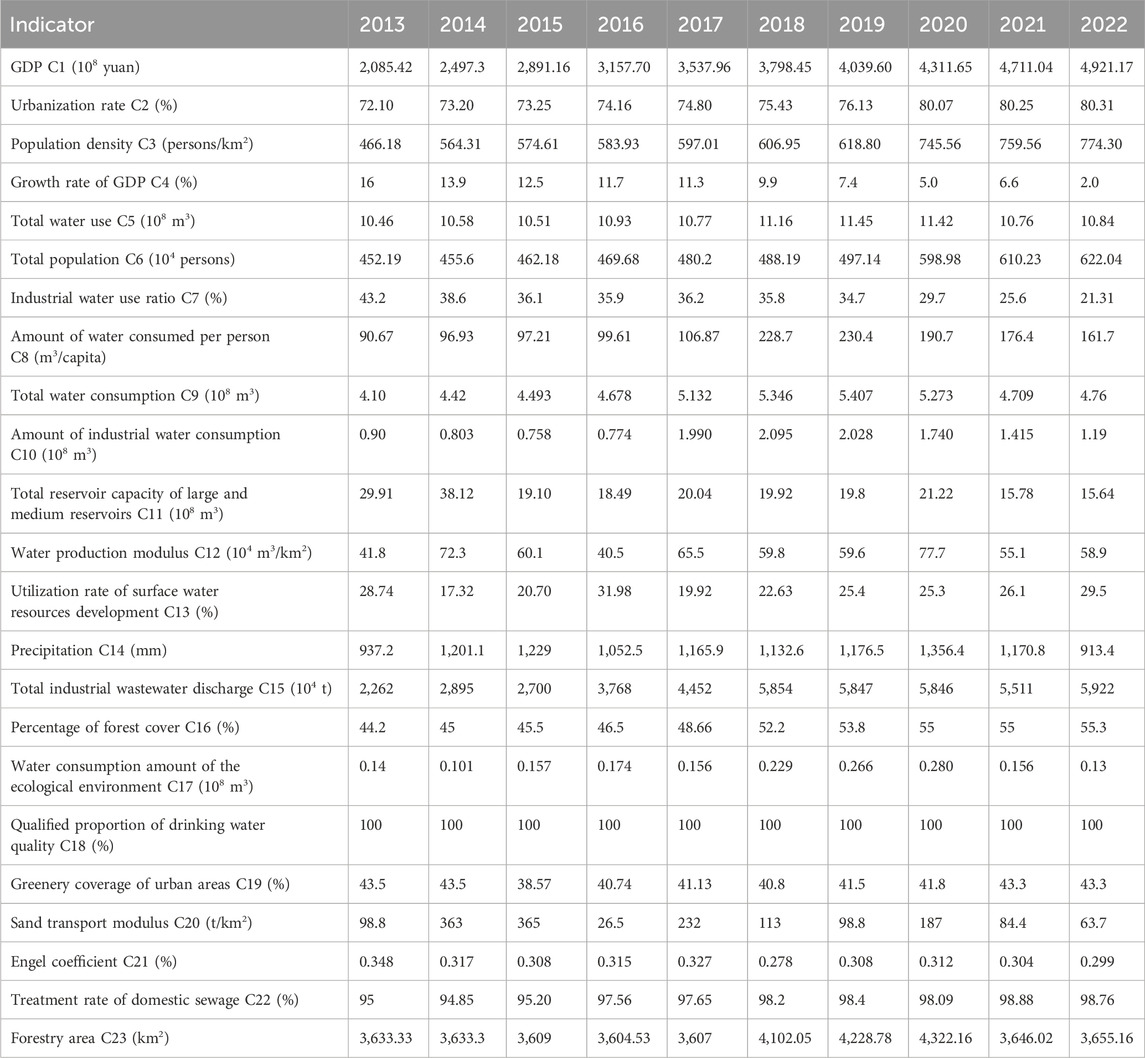
Through statistical analyses and calculation of relevant data from the Guizhou Water Resources Bulletin, Guiyang Statistic Yearbook, and Guiyang Statistic Bulletin of National Economic Development and Social Development from 2013 to 2022, each of the assessment indicators for water resource safety in Guiyang from 2013 to 2022 were obtained. The data of the specific indicators are listed in Table 3.
4 Results and discussion
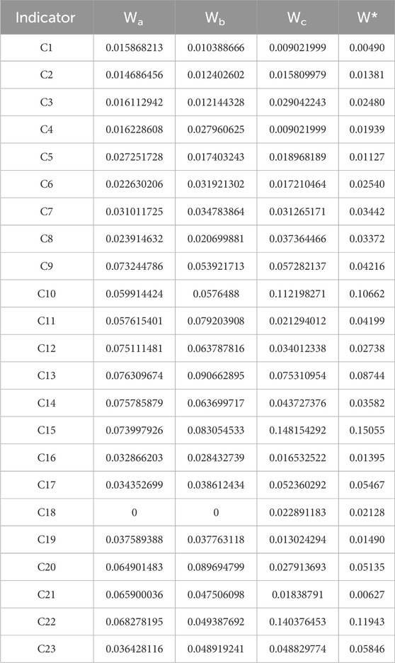
The entropy-weighted right, CRITIC, and AHP methods were used to determine the three types of basic weights for the proposed model. The coordination weight coefficients of the indicators are obtained as α*1 = 0.30317, α*2 = 0.33084, and α*3 = 0.366 using the thought method of game theory, and the coordination weights of the indicators were then obtained using the coordination weight formula. These calculation results are shown in Table 4.
4.1 Evaluation results and analysis of water resource safety in Guiyang from 2013 to 2022
There are no fixed standards for the classification of water resource safety assessment levels. Based on domestic and foreign research results and related standards [27, 28, 29, 30, 31, 32, 33], the relationships between the water resource security assessment values (proximity degrees) and their corresponding levels and security state were determined using equidistant classification, as shown in Table 5. The index data of the water resource safety assessment system for Guiyang from 2013 to 2022 were used to calculate the Nj values on the basis of the fuzzy matter–element analysis model, and the obtained assessment results are listed in Table 6. From 2013 to 2022, the state of water resource safety in Guiyang changed from good to general, showing an overall downward trend. During this period, the safety state was good from 2013 to 2017 and general from 2018 to 2022.

Table 5. Corresponding relationships between the assessment values and water resource safety grades.
4.2 Limiting factor diagnosis
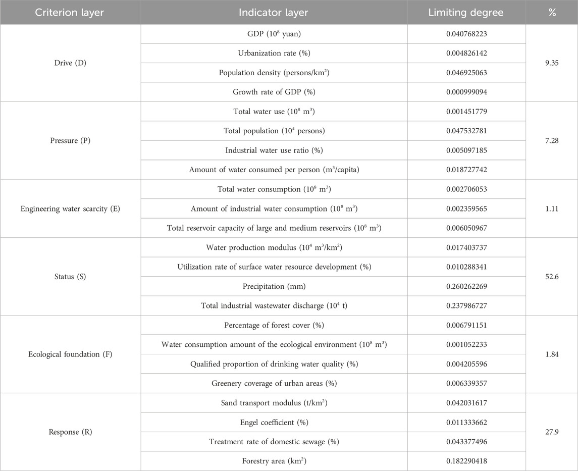
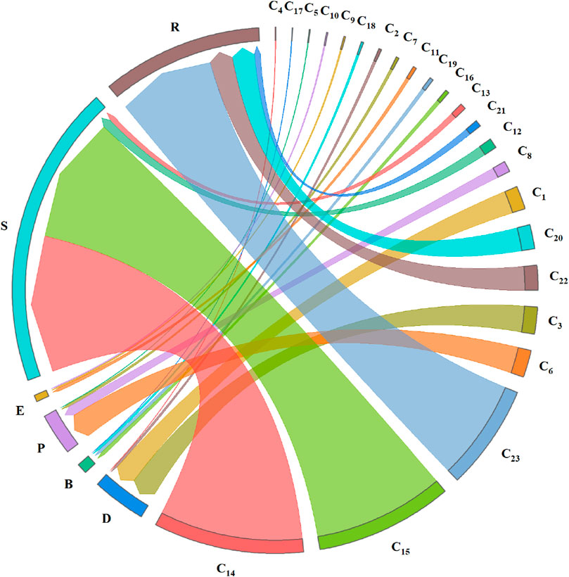
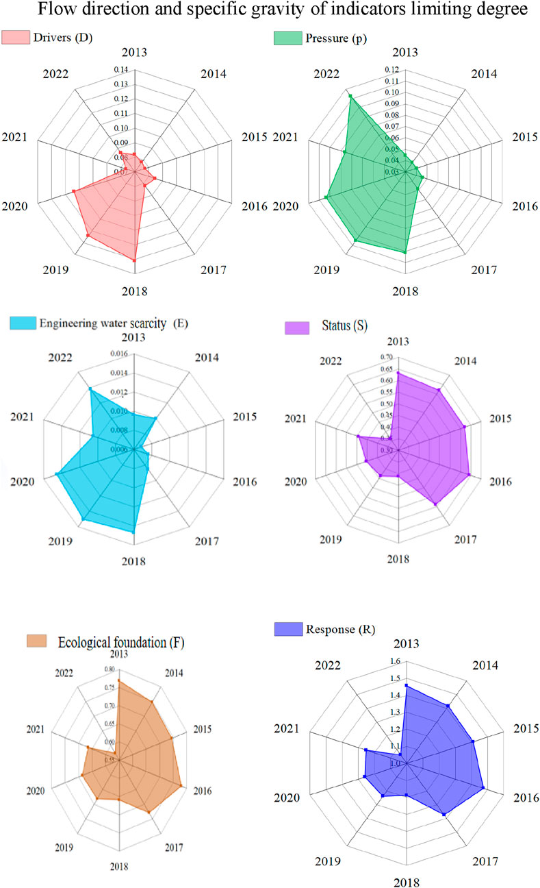
Using the limiting degree model of coordinated weights, the limiting degree of each index and each criterion layer in the water resource safety assessment system of Guiyang was obtained from 2013 to 2022, as shown in Table 7. The flow direction and specific gravity of the indicator limiting degree as well as the change in the criterion layer limiting degree are shown in Figures 1, 2. From Table 7 and Figures 1, 2, it is seen that at the criterion level, the limiting degrees in descending order are state, response, drive, pressure, ecological foundation, and engineering water scarcity. From the perspective of temporal changes, state had the greatest limiting degree from 2013 to 2017 and was the greatest threat to water resource security in Guiyang. Drive, pressure, and engineering water scarcity reached the maximum limiting degrees from 2018 to 2022, whereas state, response, and ecological foundation reached the minimum limiting degrees over the same period, indicating that water consumption for economic development was high, relevant policies were insufficient, and the ecological foundation was poor. In the case of high consumption of water resources, it is necessary to fully explore the potential for water savings and actively strengthen the management of factors affecting water security so as to alleviate the degree of regional water insecurity to a certain extent. At the same time, when the basic ecological conditions of the water resources are superior and the water resource response system is good, the water resource security state of Guiyang can be further improved by actively adjusting the economic driving and engineering water shortage systems.
At the indicator level, the greatest limiting factor among the 23 indicators was precipitation and the least limiting factor was the GDP growth rate. Owing to the large number of indicators selected in this study, the top six factors with the highest limiting degrees were selected in the indicator layer as the main limiting factors that had vital impacts on water resource safety in Guiyang. These factors (in descending order) were precipitation, total industrial wastewater discharge, forestry area, total population, population density, and treatment rate of domestic sewage. According to changes in the major limiting factors (Figure 3), the peak and least values of the limiting degrees of these six factors were mainly concentrated in 2018–2022. The influence of precipitation on the state of water security increased from 2013 to 2020, decreased in 2021, and rebounded in 2022, with the strongest and weakest effects being observed in 2020 and 2013, respectively. The overall impact of the total industrial wastewater discharge on water resource safety showed a continuous downward trend, with the strongest effect being in 2016 and the weakest effect being in 2022. The overall effects of forest area, total population, population density, and domestic sewage treatment rate on water resource security have continued increasing. Forest area, total population, and domestic sewage treatment rate had the least impact in 2014 and the greatest impact in 2022. Population density had the least impact in 2013 and the greatest impact in 2022.
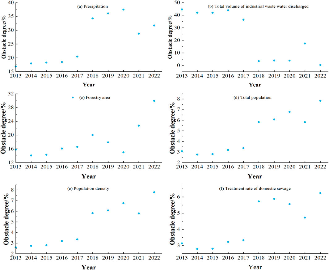
Figure 3. Changes in the limiting degrees of the main limiting factors. (A) Precipitation, (B) Total volume of industrial waste water discharged, (C) Forestry area, (D) Total population, (E) Population density (F) Treatment rate of domestic sewage.
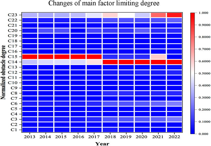
After normalizing the limiting degree data for each indicator in each year, the thermal map of the limiting degrees of the indicators was obtained, as shown in Figure 4. Over the years, it has been observed that indicators with higher limiting degrees gradually transformed into indicators with lower limiting degrees, implying that most limiting factors with greater influences gradually become common limiting factors over time. However, the limiting degrees of a few factors were highly concentrated and did not change to common limiting factors; these posed greater threats to water resource security than the other factors. Therefore, relevant measures are urgently needed to weaken the limiting degrees of these factors to reduce their threats to water security. For example, in 2022, the limiting degree of domestic sewage treatment rate exceeded 6%, which requires adhering to the treatment of domestic sewage, guiding the discharge measures for wastewater in the daily lives of residents, and promoting water savings in daily life to reduce the impacts of domestic sewage on water resource safety. In 2022, the limiting degree of population density exceeded 8%. When a region experiences rapid urban population growth, relevant policies should be adopted to guide residents to relocate to the surrounding areas so as to ensure the water quality and daily use quantities of the residents as well as reduce the influence of population density on water resource safety. With time, the indicators with high limiting degrees changed till 2018. Before 2018, the total industrial wastewater discharge had the greatest impact on the state of water resource safety in Guiyang, and its impact gradually weakened after 2018. The reason for this is not only the implementation of relevant engineering measures but also the benefits derived from various water resource regulation measures and management policies issued by Guiyang. Therefore, managing urban water resources, ameliorating the function of the urban water ecosystem, and implementing the construction of engineering facilities are some of the suggested research directions for improving the water resource safety of Guiyang in the future.
4.3 Construction of the water resource safety prediction model for Guiyang
4.3.1 ARIMA model
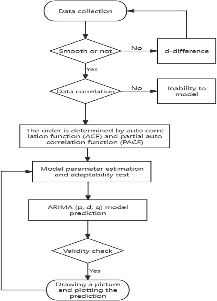
The ARIMA model is a time-series prediction method developed by Box and Jenkins in the early 1970s (Wu et al., 2023b). In the present study, ARIMA was used to predict the development trends of water resource safety in Guiyang, and the modeling process is shown in Figure 5.
Step 1: The difference data are collected and used to create the difference timing charts as well as test difference stationarity.
Step 2: The difference non-stationarity data are processed next, and the difference value d is determined.
Step 3: Using the difference values d, the difference sequence is established.
Step 4: The model is identified and graded, and the p-order and q-order values are determined using the autocorrelation function (ACF) and partial autocorrelation function (PACF).
Step 5: Parameter estimation analysis and adaptability tests of the model parameters are conducted.
Step 6: The ARIMA(p, d, q) model is used to predict the system.
4.3.2 Prediction and assessment results of water resource safety for Guiyang from 2023 to 2030
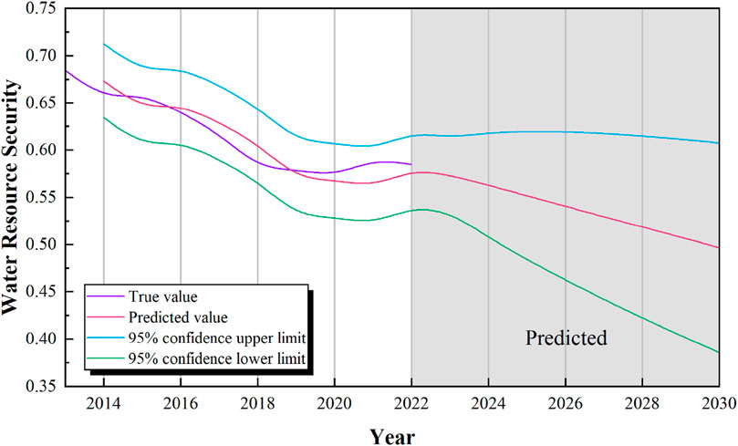
Based on the ARIMA model, the water security value of Guiyang from 2013 to 2022 was used to predict the safety for 2023–2030; these values are listed in Table 8. From Table 8 and Figure 6, it is seen that the water resource safety state of Guiyang from 2023 to 2030 is generally expected to be stable (“general”), but the predicted values from 2023 to 2030 show a downward trend. From the 95% confidence upper and lower limit curve analysis, the future security state is expected to become poor or even worse.
4.4 Discussion
Based on the water resource safety assessment framework, we combined six subsystems and selected 23 evaluation indexes with logical correlations to build a comprehensive assessment indicator system of water resource safety in Guiyang in this study. The fuzzy matter–element model was used to calculate the comprehensive level of water resource safety in Guiyang, the limiting degree model was used to analyze and diagnose the limiting factors, and the ARIMA model was used to predict the integrated level of water resource safety in Guiyang from 2023 to 2030. With regard to data procurement, the assessment indicator system needs to be improved. In addition, this study only considers the integral water resource safety assessment of Guiyang, so the correlations between surrounding cities still need to be explored.
It is important to strengthen the water resource safety level in Guiyang and firmly establish consciousness regarding this matter. Promoting the mutual promotion and coordinated development of each subsystem of the assessment framework is conducive to building a healthy water resource safety system to enhance self-regulation while reducing the occurrences of natural disasters such as droughts and floods. At the state level, production activities should minimize the total industrial wastewater discharge and urban domestic sewage discharge while reasonably utilizing surface water and groundwater resources. At the drive level, reducing the population density is an essential step. At the engineering water shortage level, reducing industrial water consumption and appropriately increasing the ecological water supply are effective methods to improve water resource security. In the future, it is important to continue increasing publicity regarding water resource protection, actively cooperating with government policies, and strengthening the water resource safety level in Guiyang.
Since there are few relevant studies regarding the study area, we reviewed the available literature and found that Yang et al. (2017) adopted the SPA-MC approach to study the water resource safety of Guiyang from 2002 to 2014; accordingly, we adopted the proposed method to obtain the water resource safety level of Guiyang from 2014 to 2022 and found that the results were in accordance with the outcomes of the present study. This indicates that the proposed approach in this study is in good agreement with the findings of previous research. Evaluating water resource safety based on the DPESFR concept and matter–element analysis models allows for the comprehensive level quantification of water resource safety. The DPESFR concept model is more in line with the actual conditions and geological characteristics of karst areas; however, this method can also be applied to study the safety levels of other resources, such as soil, minerals, and air.
5 Conclusion
In this study, the fuzzy matter–element analysis and limiting degree models were used to calculate and analyze the water resource safety of Guiyang from 2013 to 2022; we also obtained the status and change trends of water resource security in Guiyang along with studying and analyzing the corresponding limiting factors. Next, the ARIMA model was utilized to predict the state of water resource safety for Guiyang from 2023 to 2030. The relevant findings of this study are as follows.
(1) The overall level of water resource safety in Guiyang from 2013 to 2022 showed a moderate trend with each passing year. Among the six subsystems of water resource security selected in this study, the state subsystem had the greatest impact on the water resource safety level, followed by the response subsystem. In 2018, the state of water resource safety in Guiyang began to decrease from grade IV to grade III, so the service function of the water resource system needs to be improved.
(2) The largest index factors restricting the development of water resource safety in Guiyang are precipitation, total industrial wastewater discharge, forestry area, total population, population density, and treatment rate of domestic sewage, and the most important criterion layer factor is the state subsystem.
(3) The water resource safety level of Guiyang is predicted to decrease to 0.496 by 2030 and is likely to continue decreasing thereafter. Under the influence of karst geology, the water resource safety level of Guiyang has been declining yearly in recent times, and the engineering water scarcity level is low. The improvement of engineering water scarcity will thus help enhance the comprehensive level of water resource safety.
(4) Human social activities and natural conditions play important roles in water resource safety in Guiyang. While precipitation and the total amount of industrial wastewater discharge have always been the greatest limiting factors, socioeconomic developments have gradually introduced ecological constraints, such as surface water and groundwater supply.
Data availability statement
The original contributions presented in this study are included in the article/supplementary material; and any further inquiries may be directed to the corresponding authors.
Author contributions
TP: conceptualization, formal analysis, funding acquisition, methodology, software, writing–original draft, and writing–review and editing. LZ: funding acquisition, investigation, methodology, resources, supervision, and writing–review and editing. PW: methodology, software, supervision, visualization, and writing–review and editing.
Funding
The authors declare that financial support was received for the research, authorship, and/or publication of this article. This study was financially supported by the basic Guizhou combination-ZK(2024) (common 605) and research topic of humanities and social sciences in colleges and universities of the Guizhou Education Department (313).
Conflict of interest
The authors declare that the research was conducted in the absence of any commercial or financial relationships that could be construed as a potential conflict of interest.
Publisher’s note
All claims expressed in this article are solely those of the authors and do not necessarily represent those of their affiliated organizations or those of the publisher, the editors, and the reviewers. Any product that may be evaluated in this article or claim that may be made by its manufacturer is not guaranteed or endorsed by the publisher.
References
Alakbar, T., and Burgan, H. I. (2024). Regional power duration curve model for ungauged intermittent river basins. J. Water Clim. Change. Early Access 15, 4596–4612. doi:10.2166/wcc.2024.207
Chen, M. J., Zhou, Q., Duan, W. L., Xue, Q., and Chen, C. B. (2023). Using an improved ecological footprint model to analyze the sustainable utilization of water resources in Beijing-Tianjin-Hebei region. Environ. Dev. Sustain 25 (8), 8517–8538. doi:10.1007/s10668-022-02410-7
Dai, W. Y., Zhang, R., Cheng, Z. Y., Liu, J. X., Ma, Q. M., and Chen, N. N. (2015). Research on water ecological security index system in Lanzhou based on fuzzy comprehensive evaluation. Arid. Zone. Res. 32 (4), 804–809. doi:10.13866/j.azr.2015
Deng, H. W., and Li, Y. (2023). Evaluation of water resource vulnerability in Changsha city based on VSD and Cloud Matter-element model, and diagnosis of limiting factors. Bull. Soil Water Conse 43 (6), 174–184. doi:10.13961/j.cnki.stbctb.2023.06.022
Deng, H. W., Song, X. J., Li, C. S., Li, Y. Y., Diao, H., and Xu, J. B. (2022). Comprehensive evaluation on urban water security based on the novel DPEBLR concept model and the cloud matter-element model: a case study of chongqing, China. China. Water 14, 3486. doi:10.3390/w14213486
Deng, H. W., Yang, J. X., and Wang, P. (2023). Study on coupling coordination relationship between urban development intensity and water environment carrying capacity of Chengdu-Chongqing economic circle. Sustainability 15, 7111. doi:10.3390/su15097111
Jacques, G. (2022). Water security in the anthropocene: a dialectical water-man interaction model. Sustainability 14 (12), 6955. doi:10.3390/su14126955
Jemmali, H. (2017). Mapping water poverty in Africa using the improved Multidimensional Index of Water Poverty mensional index of water poverty. Int. J. Water. Resour. D. 33(4), 649–666. doi:10.1080/07900627.2016.1219941
Li, S. L., Yang, J. J., Pei, Q. M., Sha, J. H., and Liu, F. (2022). Dynamic relationship between water resources and new urbanization based on a vector autoregressive model: a case study of Hebei Province, China. Front. Env. Sci. 10, 941726. doi:10.3389/fenvs.2022.941726
Liu, Z. J., Li, B., Chen, M. Y., and Li, T. (2021). Evaluation on sustainability of water resource in karst area based on the emergy ecological footprint model and analysis of its driving factors: a case study of Guiyang city, China. Environ. Sci. Pollut. R. 28 (35), 49232–49243. doi:10.1007/s11356-021-14162-4
Lu, Q. G., Zhu, J. Z., Teng, B., and Li, W. P. (2023). Evaluation of aquifer water yield based on entropy weight-TOPSIS coupling method of Dananhu No.7 coal mine. Coal Tech. 43 (05), 201–206. doi:10.13301/j.cnki.ct.2024.05.039
Ma, Y., Ji, G. Q., Hu, Y. H., Yang, Y. O., Wang, H., Li, J. K., et al. (2024). Pla-nt evaluation modeling and application construction recycled aggregate constructed wetland based on analytic hierarchy process. Water Purif. Technol. 43 (04), 76–84. doi:10.15890/j.cnki.jsjs.2024.04.010
Miao, C. C., Wang, Z. K., and Gai, Y. W. (2024). Application of PP-AHP weight optimization model on river health evaluation based on game theory principle. Jiangsu Water Resour. 4, 25–30. doi:10.16310/j.cnki.jssl.2024.04.016
Peng, T., and Deng, H. W. (2020a). Comprehensive evaluation on water resource carrying capacity based on DPESBR framework: a case study in Guiyang, southwest China arrying capacity based on DPESBR framework: a case study in Guiyang, southwest China. J. Clean. Prod. 268, 122235. doi:10.1016/j.jclepro.2020.122235
Peng, T., and Deng, H. W. (2020b). Comprehensive evaluation on water resource carrying capacity in karst areas using cloud model with combination weighting method: a case study of Guiyang, southwest China. Environ. Sci. Pollut. R. 27, 37057–37073. doi:10.1007/s11356-020-09499-1
Peng, T., Deng, H. W., Lin, Y., and Jin, Z. Y. (2021). Assessment on water resources carrying capacity in karst areas by using an innovative DPESBRM concept model and cloud model carrying capacity in karst areas by using an innovative DPESBRM concept model and cloud model. Sci. Total Environ., 767, 144353. doi:10.1016/j.scitotenv.2020.144353
Peng, T., Jin, Z. Y., and Xiao, L. J. (2023). Assessment on water resources carrying capacity in karst areas under a novel multi-dimensional cloud model-a case study. Arab. J. Geosci. 16, 267. doi:10.1007/s12517-023-11348-7
Peng, T., and Qin, Z. X. (2019). Evaluation of urban water resources security based on set pair analysis and variable fuzzy set. Yangtze. River. 50, 88–93. doi:10.16232/j.cnki.1001-4179.2019.05.017
Qin, J., Niu, J., and Niu, W. L. (2023a). Research on water resource carrying capacity of capital water conservation functional zone. Front. Env. Sci. 10, 1108634. doi:10.3389/fenvs.2022.1108631
Qin, L., Yang, Q., and Wang, J. B. (2023b). Research on innovation and developme-nt strategy of smes based on A-SWOT model -- taking Guiyang city as an example. Man. Adm. 06, 85–91. doi:10.16517/j.cnki.cn12-1034/f.2023.06.016
Sahin, O., Siems, R., Richards, R. G., Helfer, F., and Stewart, R. A. (2017). Examin-ing the potential for energy-positive bulk-water infrastructure to provide long-term urban water security: a systems approach. J. Clean. Prod. 143, 557–566. doi:10.1016/j.jclepro.2016.12.074
Sullivan, C. (2002). Calculating a water poverty index. World. Dev. 30 (7), 1195–1210. doi:10.1016/S0305-750X(02)00035-9
Wang, P., Deng, H. W., and Liu, Y. (2024). GIS-based landslide susceptibility zoni-ng using a coupled model: a case study in Badong County, China. Environ. Sci. Pollut. R. 31 (4), 621 3–6231. doi:10.1007/s11356-023-31621-2
Wang, P., Deng, H. W., Peng, T., and Pan, Z. (2023). Measurement and analysis of water ecological carrying capacity in the Yangtze River Economic Belt, China. Sci. Pollut. R. 30 (42), 95507–95524. doi:10.1007/s11356-023-29190-5
Wang, S. H., Yin, N., and Yang, Z. H. (2021). Factors affecting sustained adoption of irrigation water-saving technologies in groundwater over-exploited areas in the North China Plain. Environ. Dev. Sustain 23 (7), 10528–10546. doi:10.1007/s10668-020-01071-8
Wang, X. Q., Li, B., and Zheng, J. (2019). Comprehensive evaluation of water res-ources security based on GRA-ANP mdoel. South-to-North. Water. Trans. Water. Sci. Tech. 17 (4), 87–93. doi:10.13476/j.cnki.nsbdqk.2019.0088
Wu, L. Z., Qian, C., Miao, K. Y., Li, J., Wang, Y. C., and Zhang, Y. (2023a). Research on water resources safety evaluation in Lanzhou. J. Safety. Environ. 23, 2939–2948. doi:10.13637/j.issn.1009-6094.2022.0838
Wu, L. Z., Qian, C., Miao, K. Y., Shen, Y. L., and Sun, D. Y. (2023b). Assessment and factor diagnosis of water resource vulnerability in arid inland river basin: a case study of Shule River Basin, China. Sustainability 15 (11), 9052. doi:10.3390/su15119052
Yang, Z. H., Su, W. C., and Li, W. (2016). Safety assessment of urban water resources in karst area based on PESBR model: a case study of Guiyang City. J Gui zhou Norm Uni (Nat. Sci. 34(05), 1–9. doi:10.16614/j.cnki.issn1004-5570.2016.05.0
Yang, Z. H., Zhou, Q. W., Guo, Y., Su, W. C., and Zhang, F. T. (2017). Dynamic assessment of water resources security in karst area based on SPA-MC model--a case study of Guiyang city. China Environ. Sci. 37(4), 1589–1600.
Yao, W., Zhou, Z. Q., and Zhang, F. T. (2019). Diagnosis and analysis of influencing factors of water resources security in Guizhou province based on PSR model. Pearl. River. 40(8), 32–38. doi:10.1007/s10668-022-02597-9
Zamri, N., Azman, W. N. A. W., Pairan, M. A., Abas, S. S., and Gao, M. M. (2023). An analysis of finding the best strategies of water security for water source areas using an integrated IT2FVIKOR with machine learning. Front. Environ. Sci. 10. doi:10.3389/fenvs.2022.971129
Zhang, J. Y., He, G., Kong, Y., He, X. X., and Peng, Z. J. (2023). Evaluation of water ecological security and limiting factors in Anhui section of Huaihe River Basin. J. He Bei. Univ. Environmen. Eng. 38 (4), 220–227. doi:10.13358/j.issn.2096-9309.2023.0
Keywords: water resource safety, drive, pressure, engineering water shortage, status, ecological foundation, and response concept model, fuzzy matter–element analysis model, Guiyang, karst areas, limiting degree
Citation: Peng T, Zhao L and Wang P (2024) Water resource safety assessment and limiting factor diagnosis based on improved concept and matter–element analysis models: a case study of a typical karst area in southwest China. Front. Environ. Sci. 12:1451365. doi: 10.3389/fenvs.2024.1451365
Received: 19 June 2024; Accepted: 05 November 2024;
Published: 03 December 2024.
Edited by:
Mohamed Ashour, National Institute of Oceanography and Fisheries (NIOF), EgyptReviewed by:
Halil Ibrahim Burgan, Akdeniz University, TürkiyeBaohui Men, North China Electric Power University, China
Copyright © 2024 Peng, Zhao and Wang. This is an open-access article distributed under the terms of the Creative Commons Attribution License (CC BY). The use, distribution or reproduction in other forums is permitted, provided the original author(s) and the copyright owner(s) are credited and that the original publication in this journal is cited, in accordance with accepted academic practice. No use, distribution or reproduction is permitted which does not comply with these terms.
*Correspondence: Lei Zhao, emw0MDIyMDc5OTFAMTI2LmNvbQ==; Peng Wang, MjI1NTAxMDE4QGNzdS5lZHUuY24=
 Tao Peng
 Lei Zhao1*