 Yeshitla Agonafir Ayenachew1,2*
 Birhanu Girma Abebe2
- 1Department of Housing and Real Estate Property Management, Ethiopian Civil Service University, Addis Ababa, Ethiopia
- 2Ethiopian Institute of Architecture, Building Construction, and City Development, Addis Ababa University, Addis Ababa, Ethiopia
Over the past two decades, Addis Ababa has witnessed a relentless transformation in its land use and land cover. Primarily driven by the conversion of agricultural land through extensive expropriation in the city’s expansion areas. The study explores the dynamic land use land cover changes and associated land expropriations from peri-urban farmers in the rapidly growing Addis Ababa, Ethiopia. The study utilized a time series of global land cover and land-use change datasets (GLAD) covering the years 2000–2020. Moreover, empirical data is gathered through a household survey conducted among 349 systematically selected expropriated farmers across four sub-cities of Addis Ababa. The findings underscore a profound shift in the city’s land use and land cover over the past two decades. The built-up area emerges as the predominant land cover, witnessing a substantial increase of 25.28% (13,150.30 ha) over the past two decades. Concurrently, agricultural land and vegetation cover decreased by 15.92% and 9.35%, respectively, indicating a significant outward expansion of the city. This expansive growth, driven by the city’s rapid development, has resulted in extensive land expropriations primarily affecting peri-urban farmers. The expropriations were mainly for housing, investment, industrial parks, and infrastructure development. Thus, we urge the city administration to carefully manage the horizontal expansion of built-up areas at the expense of the agricultural land and vegetation cover. Finally, we recommend holistic and sustainable development strategies, developed collaboratively with local communities and planners, to safeguard the long-term wellbeing of city residents.
1 Introduction
Urbanization, land use land cover (LULC) changes, and land expropriation are deeply interconnected processes that shape the development trajectories of cities worldwide. Rapid urbanization often drives significant LULC changes, which in turn are facilitated by land expropriation mechanisms used to acquire land for public development projects. The Food and Agriculture Organization (FAO, 2009) stresses the role of land expropriation in transforming land use patterns to accommodate urban growth. Consequently, urbanization has become a dominant global development agenda, with trends indicating a recurrent rise (Champion and Hugo, 2017; Murayama and Estoque, 2020). Since 2007, over half of the world’s population resides in urban areas, with projections suggesting that by 2050, 70% of the global population will become urban dwellers (Buettner, 2015; UN, 2019).
However, the degree and pace of urbanization vary significantly across regions and countries. Developed nations in Western Europe and North America have achieved high urbanization levels, exceeding 75%, primarily driven by economic development and industrialization (UN, 2018; World Bank, 2021). In contrast, developing regions in Africa and Asia experience lower urbanization levels but higher rates of urban transformation. This form of urbanization is characterized by rapid population growth, rural-urban migration, and extensive unregulated urban expansion, posing severe socio-economic and environmental challenges (Buettner, 2015; Cohen, 2006; UN, 2018).
Sub-Saharan Africa characterizes this trend with its low urbanization level but a high rate of urbanization, often called “false urbanization” due to the lack of socio-economic development driving the process. Despite this, future urbanization is projected to be highest in these regions, with Africa’s urban population expected to triple by 2050, adding 800 million people (Alaci, 2010; Annez et al., 2010; Cohen, 2006). This rapid urban expansion leads to LULC changes, primarily through increased land expropriation in peri-urban areas, adversely affecting farmers' livelihoods (Asabere et al., 2020; UN, 2018).
Ethiopia exemplifies this scenario as one of the least urbanized countries in sub-Saharan Africa, with an urbanization level of approximately 22%. However, it is currently experiencing one of the highest urbanization rates in the region (Tegenu, 2010; Adam, 2014; GebreEgziabher and Yemeru, 2019). Addis Ababa, Ethiopia’s capital, clearly illustrates this rapid urbanization, driven by high population growth and substantial migration from other parts of the country (Dorosh and Schmidt, 2010; Ozlu et al., 2015). Over the past two decades, Addis Ababa has expanded extensively into surrounding areas, altering agricultural lands and natural landscapes into urban built-up areas through land expropriation from farmers in the surrounding areas of the city (Busho et al., 2021; Terfa et al., 2019; Ayenachew and Abebe, 2024).
The conversion of LULC due to urban expansion often involves transforming agricultural land and natural vegetation into residential, commercial, and industrial developments, changing the city’s spatial structure and ecology (Graetz et al., 2016; Teklemariam and Cochrane, 2021). This urbanization process necessitates land expropriation for various urban development projects, including housing, industrial parks, real estate developments, and mega infrastructure projects (Yntiso, 2008; Kasa et al., 2011; Graetz et al., 2016; Terfa et al., 2019; Bula, 2020).
Understanding the patterns and trends of urbanization-induced LULC changes and related land expropriations in peri-urban areas is crucial for effective urban planning, resource allocation, and sustainable development. This study aims to contribute valuable understanding into the ongoing urbanization-related LULC changes and land expropriation practices in Addis Ababa, serving as a basis for policy reform, policymaking, and urban planning. Additionally, the findings also commend strategies for managing urban growth and mitigating the potential social and economic impacts associated with rapid urbanization-induced land expropriation and LULC changes.
Previous studies on LULC changes have primarily focused on rural areas, examining the effects of climate change and its impacts on urban water quality (Arsiso et al., 2018; Balew and Semaw, 2022). However, the dynamics of urbanization-induced LULC changes and related land expropriation in Addis Ababa remain understudied. This research seeks to fill this gap by exploring and analyzing the dynamic scenario of Addis Ababa’s urbanization-induced LULC changes, leading to land expropriation and its adverse effects on the livelihoods of peri-urban farmers.
This study is guided by two primary research questions: First, how does rapid urbanization lead to LULC changes in Addis Ababa? Second, how do urbanization-induced LULC changes lead to land expropriations, and how do these expropriations adversely affect farmers in the peri-urban areas of Addis Ababa, Ethiopia? The next section presents the materials and methods employed for this study. The results and discussions are addressed in the third section. Finally, the conclusion summarizes the major findings and draws policy implications.
2 Materials and methods
2.1 The study area
This study is undertaken in Addis Ababa, the capital and largest metropolitan city in Ethiopia (Figure 1). It is one of the fastest urbanizing cities in Africa driven by population and economic growth (Ozlu et al., 2015). It is not only the seat of the federal government of Ethiopia but also the African Union (AU) and its predecessor, the OAU. It also hosts the headquarters of the United Nations Economic Commission for Africa (UNECA) and numerous other continental and international organizations (Wubneh, 2013).
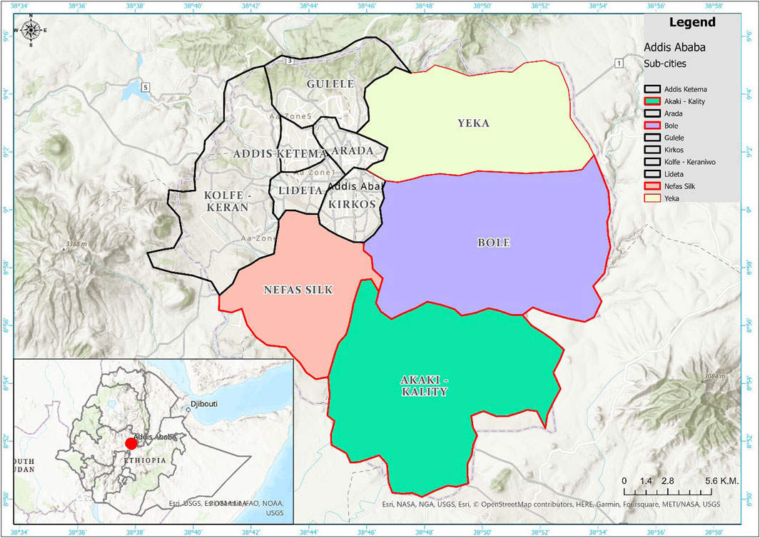
Figure 1. Map of the study area.
Addis Ababa is a chartered city with three levels of government structure, the city administration, sub-cities, and woreda. Administratively, the city is divided into eleven sub-cities which are the second administrative level next to city administration. By areal coverage size, Bole was the largest sub-city followed by Akaki-Kality and Yeka. While Addis Ketema is the smallest followed by Lideta and Arada Sub-cities. Whereas, “Lemi Kura” is the newly structured 11th sub-city which is detached from the Bole and Yeka sub-cities. The sub-cities are also divided into “woredas,” which are the smallest administrative units in the city. There are about 116 woredas in the city administration. The number of woredas varies based on their size (Central Statistical Agency (CSA, 2013). This study is conducted on samples taken from four sub-cities namely Yeka, Bole, Akaki-kality, and Nifas-silk Lafto which are purposively selected because much of the city’s expansion takes place in these sub cities and most of the expropriated farmers are also from these areas as per the data obtained from the city administration (Figure 1).
These days the population of the city is estimated to be over 5 million accounting for about 25 percent of the country’s urban population (Graetz et al., 2016). The city’s population is mounting very rapidly like many African cities and it is also projected to double in the next 10–15 years (Central Statistical Agency (CSA, 2013). While, economically, the city is considered as the engine of the nation’s economy, socio-cultural and political activities are growing very rapidly. The city alone currently contributes approximately 50% of the national GDP (UN-HABITAT, 2017). Geographically, Addis Ababa is located at 9°1′48″N latitude and 38°44′24″E longitude. The city is located at the core of the country covering a total area of 540 square kilometers. Addis Ababa is also the third highest city in the world, next to La Paz and Quito in Latin America with an altitude ranging from 2,100 m at “Akaki” in the south to 3,000 (9,800 ft) meters at “Entoto” Hill in the Northern side (Weldegebriel et al., 2023). The city has been expanding extensively and also undertaking extensive land expropriation in expansion areas of the city.
The city of Addis Ababa functions under a three-tiered government structure comprising the city administration, sub-cities, and woredas. Sub-cities, serving as the second administrative layer beneath the city administration, play a pivotal role in governance and urban management. Bole sub-city ranks as the largest sub-city in terms of area coverage, followed by Akaki-Kality and Yeka. Conversely, Addis Ketema represents the smallest sub-city, followed by Lideta and Arada. Sub-cities are further divided into woredas, constituting the smallest administrative units within the city administration. Addis Ababa incorporates approximately 116 woredas, with variations in rank based on their respective sizes (CSA, 2013). For this study, four sub-cities Yeka, Bole, Akaki-Kality, and Nifas-Silk Lafto were purposively selected due to their substantial contribution to the city’s expansion and the prevalence of expropriated farmers within these areas. Figure 1 illustrates the map of the study area, showing the four sub-cities purposively chosen for this study.
2.2 Data sources
The study utilized two major data sources. The first data source is a time series Global Land Cover and Land Use Change (GLAD) datasets which were subset to the study area extent. This land use and landcover data was produced by (Potapov et al., 2022).
The second data source is a socio-economic survey data collected from 349 land expropriated farmer households from four purposively selected sub-cities (Yeka, Bole, Akaki-Kality, and Nifas-Silk Lafto sub-cities) of Addis Ababa city Administration in 2020.
2.3 Method used
2.3.1 Land use and land cover change detection
To elucidate urbanization in the study area, land use and land cover change detections were conducted. This study used a global level of land use and land cover change products from 2000 to 2020 (Potapov et al., 2022). This global level of land use and landcover products were subset to the study area extent and the resultant change in major land use and landcovers over two decades are examined. Typical land use land cover change detection follows three major procedures. This includes the pre-processing of the input data, processing that involves image classification, and the post-processing phase which is mainly concerned with the validation of the classification result. The summary of the methods employed in generating the land use and land cover products are described below.
2.3.1.1 Landsat data
Landsat satellite image data archive enabled multidecadal monitoring of land use and landcover at a global scale at 30 m spatial resolutions. The study makes use of spatially and temporally consistent Landsat GLAD ARD inputs (https://glad.umd.edu/ard). The GLAD ARD constitutes 16-day global Landsat normalized surface reflectance and brightness temperature composites combined from the best quality observations. It processes and integrates the entire Landsat Collection 1 Tier 1 data archive over the land area between 75°N and 56°S from 1997 to 2020 (Potapov et al., 2022).
2.3.1.2 Pre-processing
Remote sensing datasets often contain anomalies that require preprocessing to enhance their utility. Overcoming issues like atmospheric scattering, absorption, and cloud interference is crucial to optimize their usefulness. The GLAD ARD image underwent a series of preprocessing steps aimed at maximizing its quality. These steps involved: 1) assessing the quality of observations, 2) Normalizing reflectance to mitigate the impact of atmospheric effects, absorption, and land surface anisotropy, and 3) aggregating the best quality data into 16-day composites. Each 16-day composite comprises normalized surface reflectance data for visible, near-infrared, and shortwave infrared Landsat bands, along with brightness temperature information. Additionally, these composites include a data quality layer indicating the presence of atmospheric contamination such as clouds, haze, cloud and topographic shadows, open water, as well as snow/ice coverage (Potapov et al., 2022).
2.3.1.3 Image classification and validation
Image classification is the process of classifying image pixels into different thematic classes. This stage can be considered as the processing stage of land use and landcover mapping. The classification outcome is often affected by classification errors and as a result, the outcome should not be taken for granted and thus needs validation of its accuracy. The accuracy assessment/validation is often the post-processing stage in land use and land cover mapping (Zhu and Woodcock, 2014). The analysis derived different landcover types except open water using consistently processed Landsat Analysis Ready Data (ARD) produced by the Global Land Analysis and Discovery Laboratories (GLAD) referred to as GLAD ARD.
Various supervised classification techniques were employed to map different land cover types. Specifically, decision tree models were individually calibrated using manually collected training data to map cropland and perennial snow and ice. To estimate forest height, a regression tree model was utilized and calibrated using forest structure measurements obtained from the Global Ecosystem Dynamics Investigation Lidar (GEDI). The identification of built-up lands relied on a deep learning convolutional neural network (CNN) algorithm trained with Open Street Map (OSM) data. These models underwent calibration either at local levels (for forest height and cropland mapping) or regionally for other land cover products. For surface water mapping, Landsat data classification per scene and time series analysis within Google Earth Engine were employed. Each global thematic product was independently validated using statistical sample analysis, with reference data gathered through visual interpretation of the most suitable high-resolution satellite images and Landsat time series (Potapov et al., 2022; Sumari et al., 2020).
2.3.1.4 Land use and landcover classes of Addis Ababa
The land use and landcover products from the above sources were subset to the study area extent for 2000, 2005, 2010, and 2020 reference years. The different land use and land covers in the city were aggregated into four major classes i.e. Built-up, Agriculture, Vegetation, and Wetland. The area of each land use and the land cover class was computed in hectares and their spatiotemporal dynamics were analyzed by comparing the -post-classification land use and land cover maps using ArcGIS software. The results were also summarized and presented with tables, graphs, and maps.
2.3.2 Socio-economic survey
The study also used a socio-economic survey method combined with field visits to collect relevant data. Primary data was obtained from expropriated farmers from four purposively selected sub-cities of Addis Ababa (i.e.,.Yeka, Bole, Akaki-Kality, and Nifas-Silk Lafto sub-cities).
The survey questionnaire was administered as a primary data generation tool. To do so, the target population comprised expropriated farmer households who lost their land due to the expropriation of land for urban development projects in four sub-cities located in the expansion areas of Addis Ababa. Household heads were selected as sample respondents. The list of expropriated farmer households was obtained from the city’s Farmers Rehabilitation & Urban Agriculture Project Office (FRUAPO) in May 2020. From the total of 5,891 expropriated farmer households in the four sub-cities, 362 samples were selected proportionally using Kothari’s 2004 formula (Kothari, 2004), considering a confidence level of 95%, a probability error of 5%, and an estimated proportion of the population. The sample included 362 affected farmer households, of which 349 contacted and completed the questionnaire, making a response rate of 96% (Kothari, 2013). Moreover, secondary data were acquired through reviews of both published and unpublished documents, such as research articles, the FDRE constitution, proclamations, regulations, and reports from relevant offices.
2.4 Methods of data analysis
The spatiotemporal land use and land cover changes were analyzed using GIS, utilizing the time-series Global Land Cover and Land Use Change (GLAD) datasets. While the collected survey data were analyzed using descriptive statistics within SPSS version 24. This analysis was further supplemented with secondary information from various reliable sources, such as reports. Results were summarized and presented using statistical tables and graphs. The findings were effectively communicated through figures, tables, and graphs to provide a comprehensive overview of the issue under study.
3 Results and discussions
The study intended to examine the dynamics of urbanization, land use land cover changes, and land expropriation in Addis Ababa in the past two decades from 2000 to 2020. For this purpose, the land use land cover classes of the city were re-classified into four major land use land cover classes since these are the dominant LULC types for this study. These are built-up areas, agriculture, vegetation, and Wetland. The proportions and changes in these land use land cover types are discussed below.
3.1 The changing scenario of Addis Ababa’s land use land cover
For this study, the Land use/land cover of Addis Ababa City was reclassified into four LULC classes as these are the major LULC types in the study area. These are Built-up areas, Agricultural, Vegetation cover, and Wetlands in 2000. Images are classified into five temporal periods (2000, 2005, 2010, and 2020) to show a clear picture of the spatial and temporal distribution of LULC change in the city (Table 1) and the rate of changes for each LULC class (Table 2). The results indicated that the built-up area covers the highest share from the LULC classes of the city accounting for 23,370.8 ha (44.92%) of the city’s total area followed by agricultural land at 17,075.5 ha (32.82%) and vegetation covers 11,558.1 ha (22.22%) of the city’s total LULC in 2000. Wetlands account for the smallest portion of the city’s LULC class which is about 24.48 ha (0.004%) of the total land area of Addis Ababa city. The land use and land cover change of the city in the past two decades is clearly illustrated in Table 1 below.
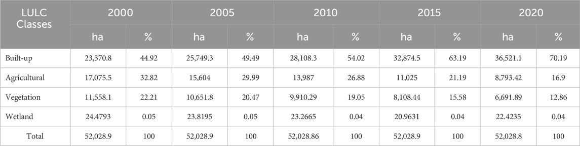
Table 1. Temporal changes of Addis Ababa’s LULC from 2000–2020.
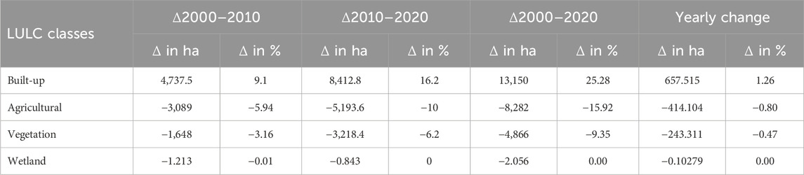
Table 2. The rate of Addis Ababa’s LULC change from 2000 to 2020.
However, after 20 years in 2020, there was a significant change in the land use/land cover classes of the city. Still, the built-up area is the dominant land use type and has increased by 13,150.30 ha (25.27%) and reached 36,521.10 ha (70.19%) of the city’s total land use land cover implying a rapid pace of urban expansion in the city mainly because of the high population growth due to the natural population growth and migration from all other regions in the country. Previous studies by Arsiso et al. (2018), Moisa and Gemeda, (2021), Balew and Semaw (2022), and Mulugeta et al. (2017) also ensured the alarming growth of the city’s built-up areas at the expense of vegetation cover and grasslands and its impact on surface urban heat and climate of Addis Ababa and the surrounding.
Contrarily, agricultural land has decreased significantly by 8,282.08 ha (15.92%) from 17,075 ha (32.82%) to 8,793.42 ha (16.90%) in 2020. Similarly, vegetation covers also decreased by 4,866.21 ha (9.35%) from 11,558.1 ha (22.22%) in 2000 to 6,691.89 ha (12.86%) in 2020. Whereas, Wetland also shows a reduction but insignificantly i.e. it decreased from 24.48 ha in 2000 to 22.4235 ha in 2020 (Table 1). Therefore, the five reference years (2000, 2005, 2010, 2015, and 2020) have clearly illustrated the dynamics of land use land cover changes of the Addis Ababa City Administration (AACA) in the past 20 years (See Table 1).
However, the degree and yearly rate of changes clearly showed the temporal changes of different LULC classes. As the result (Table 2) shows, the built-up area has been continuously increasing from 2000 to 2010 and 2010–2020. While agricultural land, vegetation cover, and wetlands are showing continuous trends of decline in the study periods from 2000 to 20,220 (Table 2). Therefore, throughout the whole study period from 2000 to 2020, the built-up area was in an increasing trend of change while the other three LULC classes were showing a decreasing trend of change. This is clear evidence that shows the rapid expansion of Addis Ababa towards the surrounding by engulfing the agricultural lands and vegetation covers. The city administration acquires land in such expansion areas for public development projects via expropriation at a low compensation rate which leads to conflicts with farmers in such areas. The survey results also indicated that expropriated farmers in the study area were adversely affected and lost their lands, income, employment, and agricultural production. The Rate of LULC Change from 2000 to 2020 in the city is clearly illustrated in Table 2 below.
Table 2 shows a comprehensive illustration of the Land Use/Land Cover (LULC) changes in Addis Ababa from 2000 to 2020, providing critical insights into the dynamic transformation of the city’s landscape. The data reveals significant shifts in various land use classes, emphasizing the city’s evolving urban environment.
Built-up areas experienced substantial growth over the two decades, with a cumulative change of 13,150 ha, representing a remarkable 25.28% increase. This indicates a rapid urban expansion, with an annual change of 657.515 ha, or a yearly growth rate of 1.26%. In this study, the built-up area encompasses artificial man-made surfaces associated with infrastructure, commercial activities, and residential land uses, as defined by Landsat spatial resolution. The analysis highlights a substantial increase in the built-up area from 2000 to 2020, reflecting a significant urbanization and developmental trajectory in Addis Ababa. Specifically, the built-up area expanded from 44.92% to 70.19%, indicating a 25.27% increase. This expansion emphasizes the dynamic nature of urbanization in Addis Ababa, driven by escalating demands for infrastructure, commercial spaces, and residential developments. Consistent with prior research by Arsiso et al. (2018) and Mulugeta et al. (2017), the study highlights a transformative shift in land use, characterized by substantial growth in built-up areas at the expense of agricultural and vegetation spaces. The comprehensive analysis captures the essence of urban development dynamics in Addis Ababa and the contentious practice of land expropriation over the specified period.
In contrast, agricultural land faced a consistent contraction, with a cumulative loss of 8,282 ha (15.92%), implying a significant reduction in agricultural practices amid rapid urbanization and continuous land expropriation by the city administration. Agricultural and vegetation covers were converted into built-up areas, amounting to 8,282.08 ha (15.92%) and 4,866.21 ha (9.35%) between 2000 and 2020, respectively. The study advocates for the implementation of checks or control mechanisms to curb the rapid expansion of the built-up area at the expense of agricultural and vegetation covers, driven by expropriation and informal developments.
In the initial period, particularly in 2000, agriculture was dominant in the eastern, southern, and southwestern parts of the city. However, a stark transformation occurred in the subsequent years, with agricultural land experiencing a considerable decline in 2005, 2010, 2015, and 2020. Simultaneously, the built-up area steadily increased in these regions, entirely at the expense of diminishing agricultural land and vegetation covers, as clearly illustrated in Figure 2 below.
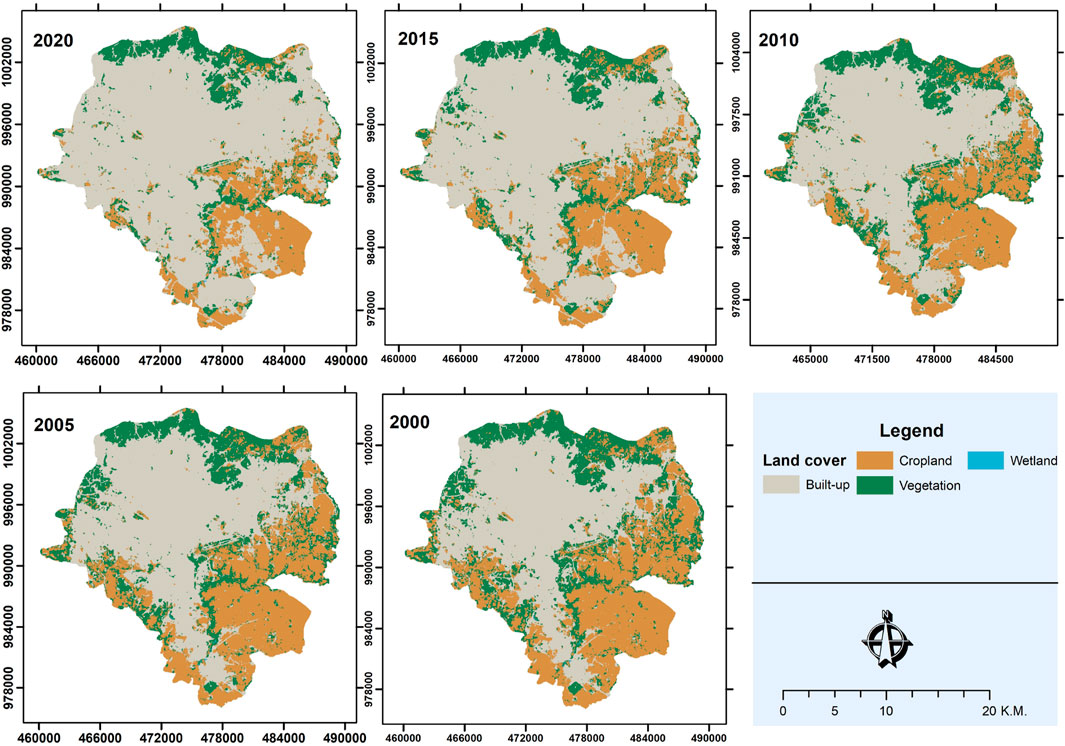
Figure 2. Trends of LULC change in Addis Ababa from 2000 to 20,202.
The findings indicate the need for sustainable urban planning practices that balance urban expansion with the preservation of agricultural and green spaces. The rapid urbanization in Addis Ababa poses significant challenges to land management and necessitates strategic interventions to ensure sustainable development while safeguarding essential ecological and agricultural resources.
Therefore, this decline underscores the horizontal growth of the city encroaching on agricultural land, primarily through compulsory land acquisition for various city development projects, including housing, real estate, industry parks, and infrastructure developments.
Whereas the vegetation cover in the city exhibited a consistent pattern of reduction, diminishing by a cumulative loss of 4,866 ha (9.35%) indicating significant environmental transformations, raising concerns about biodiversity and ecological balance similar to the findings of Arsiso et al. (2018) and Mulugeta et al. (2017). The yearly decrease of 243.31 ha (0.47%) in the city’s vegetation cover confirmed the results of previous findings. This consistent reduction in vegetation cover raises serious concerns about environmental sustainability and biodiversity degradation within and around the city, as emphasized by studies such as those conducted by Mohamed and Worku (2019).
Surprisingly, wetlands demonstrated minimal change, experiencing a decrease of 1.213 ha (0.01%) from 2000 to 2010, with almost negligible variations in the subsequent decade. The overall reduction of 2.056 ha (0.00%) and a marginal yearly change of 0.10279 ha (0.00%) suggest relative stability in wetland areas within the city. In the final analysis, wetland areas exhibited a slight reduction from 24.4793 ha (0.047%) in 2000 to 22.42 ha (0.043%) in 2020. The change of 2.0558 ha, equivalent to a 0.004% decrease, implies a degree of stability in wetland coverage despite the broader landscape transformations witnessed in the city over the past two decades.
Therefore, this comprehensive analysis of LULC changes in Addis Ababa indicated the intricate interplay between urbanization, LULC changes, and related land expropriation dynamics. The noticeable trends underline the need for sustainable land management practices to balance the imperatives of urban growth with environmental conservation and agricultural resilience. The findings highlighted the swift urbanization and horizontal expansion of Addis Ababa City, notably at the expense of diminishing agricultural and vegetation covers due to their conversion into built-up urban areas through land expropriation from farmers. This conversion has tangible consequences, adversely affecting agricultural production, farmers' livelihoods, and ecosystem services. The prevalent practice of extensive land expropriation by the city administration, particularly in expansion areas of the city like in Yeka, Bole, Akaki-Kality, Nifas-Silk Lafto, and Kolfe Keranyo sub-cities, clearly indicates this urban shift. Moreover, the survey results also support this trend, indicating that over 6,431 household farmers have faced displacement through expropriation in these five sub-cities. The uncontrolled expansion of the city, coupled with widespread land expropriation for major urban development initiatives such as condominium housing projects (Koye Feche, Tulu Dimtu, Bole Arabsa, Gelan, Jemmo, Yeka Abado condominiums), industry and ICT park developments, Addis Ababa Bole Airport expansion projects, and other infrastructure development projects has led to the displacement of numerous farming communities in Addis Ababa as previously confirmed by Kasa et al., 2011, and Teklemariam and Cochrane (2021).
3.2 Urbanization and land expropriation in Addis Ababa
Addis Ababa has experienced rapid urbanization over the past two decades, a trend supported by the findings of Terfa et al. (2019) and Ozlu et al. (2015). The city’s population has surged due to both natural growth and significant rural-urban migration, with current estimates placing the population at over 5 million, according to the Central Statistical Agency of Ethiopia (CSA, 2013). This demographic expansion has been accompanied by notable increases in urban development, as reflected in the substantial population growth, urban expansion, and shifts in built-up areas reported by Arsiso et al. (2018) and Mulugeta et al. (2017). Specifically, the built-up area of Addis Ababa has expanded dramatically, with a cumulative increase of 13,150 ha from 2000 to 2020, representing a 25.28% rise. This robust urban expansion indicates a yearly change of 657.515 ha or an annual growth rate of 1.26%. The city’s growth has predominantly taken the form of peripheral expansion, integrating agricultural and other land uses from surrounding areas.
This peripheral expansion has been facilitated through extensive land expropriation, leading to substantial losses in agricultural land, income, agricultural production, vegetation covers, and wetlands. The nexus between urban growth, land use land cover (LULC) changes, and extensive land expropriation for development projects such as residential areas, commercial centers, and infrastructure initiatives has had profound implications. Studies by Bula (2020), Haregeweyn et al. (2012), and Teklemariam and Cochrane (2021) substantiate these findings, highlighting the significant disruptions caused to the lives of displaced farmers.
The rapid urbanization of Addis Ababa has necessitated the conversion of peripheral agricultural lands into urban built-up areas. This transformation has been primarily driven by the city’s need to accommodate its growing population and expand its infrastructure. As a result, the local government has engaged in extensive land expropriation to secure land for development projects. However, this process has often involved inadequate compensation and insufficient relocation assistance for the affected farmers. The displacement of farmers without adequate support has led to a loss of livelihoods, as these individuals are forced to abandon their agricultural activities and adapt to new, often less stable, forms of employment. This finding also substantiates the results of Busho et al. (2021).
Moreover, the environmental impact of this urban expansion cannot be overlooked. The conversion of agricultural land and natural landscapes into urban areas has led to a decline in vegetation cover and the loss of wetlands, which are crucial for maintaining ecological balance. The reduction in agricultural production also has broader implications for food security and the local economy, as many farmers rely on their land for both subsistence and income.
Overall, the rapid urbanization of Addis Ababa has resulted in extensive land expropriation in the city’s periphery, leading to significant socio-economic and environmental consequences. The process of urban growth has displaced many farmers, disrupted their livelihoods and caused substantial agricultural and ecological losses. Addressing these challenges requires a comprehensive approach that includes fair compensation, adequate relocation assistance, and sustainable urban planning to ensure that the benefits of urbanization are equitably distributed and that the adverse impacts on displaced communities and the environment are mitigated.
Figure 3 illustrates the number of farmers displaced in Addis Ababa over the past years across five sub-cities. Bole sub-city stands out with the highest number of displaced farmers at (2,089), followed by Nifas-Silk Lafto (1,554), Akaki-Kality (1,410), Yeka (838), and Kolfe-Keranyo with the lowest count of 540 displaced farmers. In total, the data reveals that more than 6,431 farmer households have been displaced by expropriation in Addis Ababa City Administration. The number of displaced farmers varies among the different sub-cities related to the sub-cities locations and their suitability for diverse urban development projects like infrastructure, residential areas, and industries.
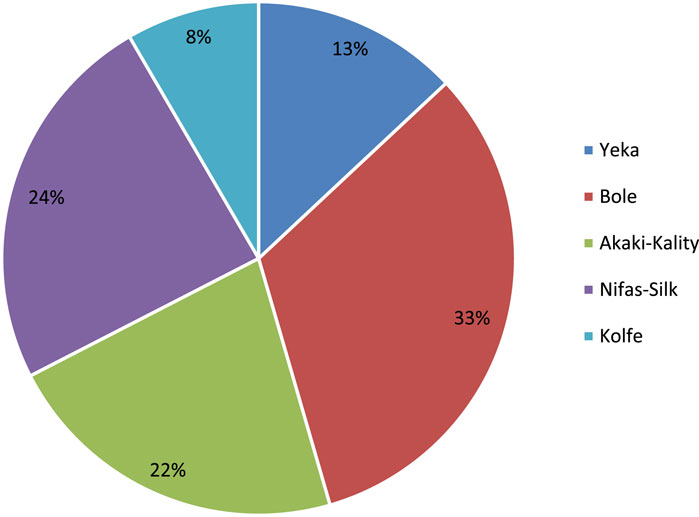
Figure 3. Number of displaced farmers by expropriation (AACA, 2020).
As indicated in (Table 3), land expropriation in Addis Ababa is predominantly driven by four main purposes: condominium housing development (62.46%), investment (21.49%), industry and ICT parks (8.88%), and infrastructure development (7.16%). This strategic allocation of land highlights the city’s efforts to address housing shortages, stimulate economic growth, promote industrialization, and enhance urban infrastructure.
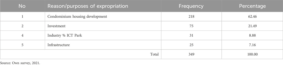
Table 3. The purposes of Land expropriation.
However, the socio-economic survey results underscore significant adverse effects on the livelihoods of expropriated farmers. A notable 45.5% decrease in their income illustrates the severe economic challenges faced by these individuals, who have lost their primary source of livelihood. Before expropriation, 99% of the respondents were engaged in agriculture, but post-expropriation, there has been an immense shift in employment status. The unemployment rate among farmers increased by 33%, and 42.4% of them transitioned to temporary, and low-income jobs. It is only 24.6% of the expropriated farmers, particularly those with better educational backgrounds, secured permanent employment, showing a significant disparity in the post-expropriation job conditions. This situation indicates the critical role of education in enabling former farmers to access stable and higher-income generating jobs. These findings highlight the urgent need for comprehensive resettlement, and rehabilitation support arrangements, such as fair compensation, resettlement assistance, and vocational training programs, to enhance the transition of the displaced farmers into new urban-based livelihoods. Moreover, promoting inclusive urban planning and development that considers the needs of peri-urban communities is essential for ensuring that urban growth benefits all residents equitably, thus fostering sustainable and socially responsible development in Addis Ababa City.
3.3 Conclusion and policy implications of the study
This study examined the urban expansion-induced Land Use Land Cover (LULC) changes and related land expropriations in Addis Ababa, shedding light on their profound implications. The findings reveal that Addis Ababa is undergoing rapid urbanization, with significant changes in LULC types over the past two decades. For instance, the built-up area of the city has increased dramatically by 25.28% from 2000 to 2020. This substantial growth in built-up areas especially in the fringe areas of the city like in Bole, Nifas-Silk, Akaki-Kality, Yeka, and Kolfe-Keraniyo sub-cities indicates the swift and extensive urban expansion in the city.
Whereas agricultural land and vegetation cover decreased by 15.92% and 9.35%, respectively, over the past 20 years due to the influence of the expanding built-up areas, resulting in the expropriation of land from many farmers. This shift in land use patterns has significant implications for food security, environmental sustainability, and biodiversity. Urban expansion-induced land expropriation has profoundly affected farmers' livelihoods, causing loss of fertile land, income, employment, and food production, leading to increased impoverishment among affected communities.
The rapid urbanization and expansion of Addis Ababa City are attributed to drivers such as population growth and economic development. Population growth was driven by both high rural-urban migration and very high natural increase, which led to an increased demand for housing, infrastructure, and services.
To address these challenges, the study recommends that the city administration should take measures to control the city’s growth, which currently occurs at the expense of agricultural land and vegetation, by adversely affecting farmers' livelihoods. An inclusive and sustainable approach to urban development should be adopted, to minimize land expropriation and promote inclusive and resilient urban growth. The city administration should collaborate with communities and urban planners to guide Addis Ababa towards an environmentally conscious urban center, conserving natural resources for future generations.
Thus, the findings of this study are significant for understanding the dynamics of urbanization-induced LULC changes and land expropriation practices in Addis Ababa. Recognizing these changes is crucial for adjusting urban development policies, strategies, and directives to manage the city’s expansion wisely and mitigate the adverse effects of land expropriations in peri-urban areas. The study also serves as a valuable reference for further studies on similar issues in Ethiopian cities or other developing countries.
However, the study’s scope was limited in certain parts of the city due to time and financial constraints. Therefore, further detailed and comprehensive studies should be conducted, including an examination of the driving forces behind urbanization and the related challenges. Addressing these issues is essential for ensuring sustainable urban development and improving the livelihoods of affected communities.
Data availability statement
The original data supporting the conclusion of this article will be made available by the authors, without undue reservation.
Ethics statement
Ethical review and approval was not required for the study on human participants in accordance with the local legislation and institutional requirements. Written informed consent from the [patients/ participants OR patients/participants legal guardian/next of kin] was not required to participate in this study in accordance with the national legislation and the institutional requirements.
Author contributions
YAA: Conceptualization, Data curation, Formal Analysis, Funding acquisition, Investigation, Methodology, Resources, Software, Supervision, Validation, Visualization, Writing–original draft, Writing–review and editing. BGA: Conceptualization, Data curation, Formal Analysis, Funding acquisition, Investigation, Methodology, Resources, Software, Supervision, Validation, Visualization, Writing–original draft, Writing–review and editing.
Funding
The author(s) declare that no financial support was received for the research, authorship, and/or publication of this article.
Acknowledgments
We extend our sincere appreciation to the Ethiopian Civil Service University for its sponsorship, and Addis Ababa University for granting the Ph.D. education of the corresponding author. We are grateful to the survey respondent farmers in the study areas, as well as to the experts and officials of Addis Ababa city administration, for their valuable contributions and cooperation. The authors also thank the editor and the reviewers for their support and genuine comments that improved the quality of the manuscript.
Conflict of interest
The authors declare that the research was conducted in the absence of any commercial or financial relationships that could be construed as a potential conflict of interest.
Publisher’s note
All claims expressed in this article are solely those of the authors and do not necessarily represent those of their affiliated organizations, or those of the publisher, the editors and the reviewers. Any product that may be evaluated in this article, or claim that may be made by its manufacturer, is not guaranteed or endorsed by the publisher.
References
Adam, A. G. (2014). Land tenure in the changing Peri-urban areas of Ethiopia: the case of Bahir Dar City. Int. J. Urban Reg. Res. 38, 1970–1984. doi:10.1111/1468-2427.12123
Alaci, D. S. A. (2010). Regulating urbanization in Sub-Saharan Africa through cluster settlements: lessons for urban managers in Ethiopia. Theor. Empir. Res. Urban Manag. 5 (14), 20–34.
Annez, P., Buckley, R., and Kalarickal, J. (2010). African urbanization as flight? Some policy implications of geography. Urban Forum 21 (3), 221–234. doi:10.1007/s12132-010-9085-6
Arsiso, B. K., Mengistu Tsidu, G., Stoffberg, G. H., and Tadesse, T. (2018). Influence of urbanization-driven land use/cover change on climate: the case of Addis Ababa, Ethiopia. Phys. Chem. Earth, Parts A/B/C 105, 212–223. doi:10.1016/j.pce.2018.02.009
Asabere, S. B., Acheampong, R. A., Ashiagbor, G., Beckers, S. C., Keck, M., Erasmi, S., et al. (2020). Urbanization, land use transformation and spatio-environmental impacts: analyses of trends and implications in major metropolitan regions of Ghana. Land Use Policy 96, 104707. doi:10.1016/j.landusepol.2020.104707
Ayenachew, Y. A., and Abebe, B. G. (2024). Navigating urbanization implications: effects of land expropriation on farmers’ livelihoods in Addis Ababa, Ethiopia. Front. Sustain. Cities. 6, 1385309. doi:10.3389/frsc.2024.1385309
Balew, A., and Semaw, F. (2022). Impacts of land-use and land-cover changes on surface urban heat islands in Addis Ababa city and its surrounding. Environ. Dev. Sustain. 24 (1), 832–866. doi:10.1007/s10668-021-01472-3
Buettner, T. (2015). Urban estimates and projections at the united nations: the strengths, weaknesses, and underpinnings of the world urbanization prospects. Spat. Demogr. 3 (2), 91–108. doi:10.1007/s40980-015-0004-2
Bula, S. W. (2020). They deceived us: narratives of Addis Ababa development-induced displaced peasants. Int. J. Sociol. Anthropol. 12 (3), 67–75. doi:10.5897/ijsa2020.0862
Busho, S. W., Wendimagegn, G. T., and Muleta, A. T. (2021). Quantifying spatial patterns of urbanization: growth types, rates, and changes in Addis Ababa City from 1990 to 2020. Spatial Inf. Res. 29 (5), 699–713. doi:10.1007/s41324-021-00388-4
Champion, T., and Hugo, G. (2017). New forms of urbanization: London. Routledge. doi:10.4324/9781315248073
Cohen, B. (2006). Urbanization in developing countries: current trends, future projections, and key challenges for sustainability. Technol. Soc. 28 (1–2), 63–80. doi:10.1016/j.techsoc.2005.10.005
CSA (2013). Population projections for Ethiopia 2007-2037. Addis Ababa, Ethiopia: federal democratic republic of Ethiopia. Popul. Census Comm.
Dorosh, P., and Schmidt, E. (2010). The rural-urban transformation in Ethiopia. ESSP working papers.
GebreEgziabher, T., and Yemeru, E. A. (2019). Urbanization and industrial development in Ethiopia. Oxf. Handb. Ethiop. Econ., 784–803. doi:10.1093/oxfordhb/9780198814986.013.40
GebreEgziabher, T. T. (2014) “The effect of development induced displacement on relocated household: the case of Addis Ababa,” in: MA in development studies. The Hague, Netherlands.
Graetz, M., Kalev, G., and Kloosterboer, M. (2016). My space? The transformation of Ethiopia’s capital Addis Ababa. Yale Journal of International Affairs 11, 67–72. Available at: http://yalejournal.org/photo-essay_post/my-space-addis-ababa/(Accessed August 10, 2016).
Haregeweyn, N., Fikadu, G., Tsunekawa, A., Tsubo, M., and Meshesha, D. T. (2012). The dynamics of urban expansion and its impacts on land use/land cover change and small-scale farmers living near the urban fringe: a case study of Bahir Dar, Ethiopia. Landsc. Urban Plan. 106 (2), 149–157. doi:10.1016/j.landurbplan.2012.02.016
Kasa, L., Zeleke, G., Alemu, D., Hagos, F., and Heiniman, A. (2011) “Impact of urbanization of Addis Abeba City on the peri-urban environment and livelihoods,” in Sekota dry land agricultural research centre of amhara regional agricultural research institute. Addis Ababa, Ethiopia.
Kothari, C. (2013). Research methods and techniques. New Delhi India: University of Health Sciences.
Kothari, C. R. (2004). Research methodology: methods and techniques. New Delhi India: New Age International.
Mohamed, A., and Worku, H. (2019). Quantification of the land use/land cover dynamics and the degree of urban growth goodness for sustainable urban land use planning in Addis Ababa and the surrounding Oromia special zone. J. Urban Manag. 8 (1), 145–158. doi:10.1016/j.jum.2018.11.002
Moisa, M. B., and Gemeda, D. O. (2021). Analysis of urban expansion and land use/land cover changes using geospatial techniques: a case of Addis Ababa City, Ethiopia. Appl. Geomatics 13 (4), 853–861. doi:10.1007/s12518-021-00397-w
Mulugeta, M., Tesfaye, B., and Ayano, A. (2017). Data on spatiotemporal land use land cover changes in peri-urban Addis Ababa, Ethiopia: empirical evidences from Koye-Feche and Qilinto peri-urban areas. Data Brief 12, 380–385. doi:10.1016/j.dib.2017.04.018
Murayama, Y., and Estoque, R. C. (2020). Urbanization: concept, mechanism, and global implications. In: Y. Himiyama, K. Satake, and T. Oki (eds). Human Geoscience. Advances in Geological Science Singapore: Springer 261–282. doi:10.1007/978-981-32-9224-6_19
Ozlu, M. O., Alemayehu, A., Mukim, M., Lall, S. V., Kerr, O. T., Kaganova, O., et al. (2015). Ethiopia-Urbanization review: urban institutions for a middle-income Ethiopia. Washington D.C.: World Bank Group, 1–168. No. 100238.
Potapov, P., Hansen, M. C., Pickens, A., Hernandez-Serna, A., Tyukavina, A., Turubanova, S., et al. (2022). The global 2000-2020 land cover and land use change dataset derived from the Landsat archive: first results. Front. Remote Sens. 3. doi:10.3389/frsen.2022.856903
Sumari, N. S., Cobbinah, P. B., Ujoh, F., and Xu, G. (2020). On the absurdity of rapid urbanization: spatio-temporal analysis of land-use changes in Morogoro, Tanzania. Cities 107, 102876. doi:10.1016/j.cities.2020.102876
Tegenu, T. (2010). Urbanization in Ethiopia: study on growth, patterns, functions and alternative policy Strategy.
Teklemariam, A., and Cochrane, L. (2021). The rush to the peripheries: land rights and tenure security in peri-urban Ethiopia. Land 10 (2), 193. doi:10.3390/land10020193
Terfa, B. K., Chen, N., Liu, D., Zhang, X., and Niyogi, D. (2019). Urban expansion in Ethiopia from 1987 to 2017: characteristics, spatial patterns, and driving forces. Sustainability 11 (10), 2973. doi:10.3390/su11102973
UN-Habitat (2017). The state of Addis Ababa 2017: the Addis Ababa we want. Available at: https://unhabitat.org/the-state-of-addis-ababa-2017-the-addis-ababa-we-want (Accessed August 25, 2017).
United Nations, Department of Economic and Social Affairs, Population Division (2018). The world’s cities in 2018 Data booklet (ST/ESA/SER.A/417). New York: United Nations.
United Nations, Department of Economic and Social Affairs, Population Division (2019). World urbanization prospects: the 2018 revision (ST/ESA/SER.A/420). New York: United Nations.
Weldegebriel, A. T., Tekalign, M., and Van Rompaey, A. (2023). Socio-spatial analysis of regime shifts in Addis Ababa's urbanisation. Appl. Geogr. 154, 102918. doi:10.1016/j.apgeog.2023.102918
World Bank (2021). World Bank data: population. World bank data website. Available at: https://databank.worldbank.org/embed/2021-Population-Data/id/67b1e32b (Accessed March 22, 2022).
Wubneh, M. (2013). Addis Ababa, Ethiopia – Africa’s diplomatic capital. Cities 35, 255–269. doi:10.1016/j.cities.2013.08.002
Yntiso, G. (2008). Urban development and displacement in Addis Ababa: the impact of resettlement projects on low-income households. East. Afr. Soc. Sci. Res. Rev. 24 (2), 53–77. doi:10.1353/eas.0.0001
Keywords: urbanization, urban expansion, land use change, land expropriation, Addis Ababa, Ethiopia
Citation: Ayenachew YA and Abebe BG (2024) The dynamics of urbanization, land use land cover changes, and land expropriation in Addis Ababa, Ethiopia. Front. Environ. Sci. 12:1439954. doi: 10.3389/fenvs.2024.1439954
Received: 28 May 2024; Accepted: 19 August 2024;
Published: 29 August 2024.
Edited by:
Merja H. Tölle, University of Kassel, GermanyReviewed by:
Shah Md Atiqul Haq, Shahjalal University of Science and Technology, BangladeshClaudio Fabian Szlafsztein, Federal University of Pará, Brazil
Copyright © 2024 Ayenachew and Abebe. This is an open-access article distributed under the terms of the Creative Commons Attribution License (CC BY). The use, distribution or reproduction in other forums is permitted, provided the original author(s) and the copyright owner(s) are credited and that the original publication in this journal is cited, in accordance with accepted academic practice. No use, distribution or reproduction is permitted which does not comply with these terms.
*Correspondence: Yeshitla Agonafir Ayenachew, eWVzaGF3MTIzQGdtYWlsLmNvbQ==