 Jianfeng Wu1,2,3
 Zhongyang Guo1,3*Guangjie Luo2
 Fengtai Zhang4Jingpeng Chen1,3Wei Li5Qiwei Chen2Jingjing Liao2Guangjie Cao2
- 1Key Laboratory of Geographic Information Sicence, Ministry of Education, East China Normal University, Shanghai, China
- 2Guizhou Provincial Key Laboratory of Geographic State Monitoring of Watershed, Guizhou Education University, Guiyang, China
- 3School of Geographic Sciences, East China Normal University, Shanghai, China
- 4School of Management, Chongqing University of Technology, Chongqing, China
- 5Institute of Mountain Resource, Guizhou Academy of Sciences, Guiyang, China
Rapid urbanization induces significant changes in land use, exerting a profound impact on regional habitat quality. Understanding the interconnectedness of urbanization and habitat quality is crucial for safeguarding the regional ecological environment and promoting sustainable urban development. Cities along the Yangtze River, as the core region of the Yangtze River Economic Belt in China, serve as a typical and critically important area to investigate the dynamic response of habitat quality to rapid urbanization. This study employs the InVEST model and entropy method to assess the spatiotemporal dynamics of habitat quality and urbanization in Yangtze River cities. Using the coupling coordination degree model, it analyzes the interplay between urbanization and habitat quality, elucidating dynamic response patterns and emphasizing the need for pertinent policy measures. Our findings reveal that from 1990 to 2019, urbanization levels in the study area surged by over six times, while habitat quality consistently declined, reflecting a 4.5% decrease. Notably, spatial variances were observed along the upstream, midstream, and downstream segments of the river. Although an inverse relationship between urbanization and habitat quality predominates, three cities demonstrated a positive correlation. The study also indicates a stable increase in the coupling coordination degree between urbanization and habitat quality, evolving from a phase of urbanization lag to one of synchronization followed by habitat quality lag. Among the cities, Chongqing emerges as an exemplary model for the coordinated development of urbanization and habitat quality. These insights provide a theoretical foundation and policy guidance for enhancing sustainable urban and ecological strategies in the region.
1 Introduction
The process of urbanization has played a significant role in advancing human living standards and is considered an unavoidable trajectory of global development. The worldwide urbanization rate surged from 39% in 1980 to 55% in 2018 (Ouyang et al., 2021; Zhong et al., 2023), Projections indicate that by 2050, the global urban population is anticipated to hit 68% (Sun et al., 2024). Over the past three decades, China has undergone a notable surge in urbanization. The urbanization rate has witnessed a remarkable increase, rising from 17.9% during the initial phase of reform and opening up to 60.6% in 2019. By the year 2030, China is anticipated to achieve an urbanization rate of 70%, with its urban population projected to increase by nearly 200 million (Ning et al., 2022), a growth that will exceed the global average during that timeframe (National Bureau of Statistics of China, 2018). The acceleration of urbanization has been a catalyst for urban growth and advancement. Concurrently, this process has instigated a suite of eco-environmental concerns. These include the deterioration of urban soil and hydrological purity (Li and Liu, 2019), water resource shortage (Hongrui et al., 2017), biodiversity reduction (Leung and Gonzalez, 2024), habitat quality degradation (Wang et al., 2023a; Mondal et al., 2024), and ecosystem imbalance (Bai et al., 2023). As urbanization intensifies, there is an increasingly critical demand for ecosystem services within natural habitats to sustain environmental balance and biodiversity. The escalation of environmental degradation, coupled with its adverse effects (Wang et al., 2023a), leads to irreversible damage to both ecosystem vitality and human wellbeing (Song et al., 2020; Mahecha et al., 2022). Accordingly, mitigating urban sprawl’s adverse effects on ecological systems and promoting a sustainable equilibrium between urban development and ecological conservation remain imperative challenges confronting modern society.
Assessing the regional ecological environment frequently involves evaluating habitat quality, recognized as a crucial indicator (Lin et al., 2024). Habitat quality is indicative of an ecosystem’s ability to support the survival and growth of various species (Chen and Liu, 2024), acting as an indicator for both biodiversity and the provision of ecosystem services (Zhang T. et al., 2020). Numerous studies have pinpointed urbanization as the principal driver behind the degradation of habitat quality (Liu et al., 2022). As urbanization progresses, key ecological areas such as farmlands, forests, grasslands, and aquatic zones are increasingly encroached upon, transforming vast natural habitats into impermeable surfaces, which results in significant habitat loss (Ren et al., 2023). This transformation significantly affects the productivity and the capacity to provide services within regional ecosystems (Tang et al., 2020). However, urbanization is inevitable in the global process (Lyu et al., 2018). The aim is to identify the necessary policies and actions to facilitate the integrated and harmonious development of urbanization and habitat quality. This strategy seeks to ensure urban growth does not hinder progress while also safeguarding against the deterioration of habitat quality. Fortunately, the United Nations and governments have proactively implemented measures to safeguard the ecological environment of the Earth. For instance, in 1992, the United Nations Environment Program initiated the “Convention on Biological Diversity.” Subsequently, conferences held in 2016, 2019, and 2022 under the Convention on Biological Diversity focused on promoting biodiversity conservation and its sustainable use (Stephens, 2023). The Chinese government has implemented a strategic initiative known as “vigorously promoting ecological civilization”. This initiative involves heightened efforts to safeguard natural ecosystems and the environment, with the ultimate goal of collaboratively establishing a global community that values all forms of life on Earth. The implementation of these measures has effectively reduced the degradation of the local ecological environment and established a solid basis for achieving sustainable development.
To foster a synergistic development of urbanization and habitat quality, there is a critical need for understanding their intricate relationship. This imperative extends beyond academic focus, evolving into a pressing global strategic challenge for governments. Habitat quality is a vital indicator of ecological health, and recent scholarly discussions highlight urbanization as a key driver of changes in habitat quality (Qiao et al., 2023). Previous studies, including those conducted in Hangzhou, China, have demonstrated the negative effects of swift urbanization on habitat quality (Zhu et al., 2020). Similarly, investigations within the Pearl River Delta have demonstrated an association between expansive urban development and the declining condition of habitats over time (Wu J. et al., 2021). Rapid urbanization in coastal urban clusters has been associated with a deterioration in habitat quality and a reduction in biodiversity (Wang F. et al., 2022). Studies focusing on the Yangtze River Economic Belt have documented a 2.33% decrease in habitat quality amid urban growth between 2010 and 2018 (Chen et al., 2021). Urban expansion, propelled by urbanization, emerges as a significant contributor to the degradation of regional habitat quality. Yet, scholars note that policy interventions focused on ecological conservation and urban development can alleviate the decline in regional habitat quality. In some cities, an enhancement in habitat quality has been observed, indicating a more symbiotic interaction with urbanization and resulting in a mutually beneficial outcome for both urban development and ecological conservation. For instance, ecological preservation initiatives in the Yangtze River Economic Belt have effectively halted the decline in ecosystem services value (Luo et al., 2019; Yang et al., 2024). Further investigations indicate that efforts in ecological restoration, including the transformation of agricultural lands into forested regions, have played a role in decelerating the deterioration of habitat quality (Zhang X. et al., 2020; Jiang et al., 2023). Following the designation of the Grand Canal as a World Cultural Heritage site, there was a notable improvement in urban habitat quality, with most cities developing in a more harmonized direction, which is directly related to the implementation of ecological protection policies (Tang et al., 2022). While considerable study has been devoted to urbanization’s influence on ecological environmental quality, in-depth analyses focusing on urbanization’s effects on habitat quality are comparatively rare. The dynamic reactions and processes by which habitat quality responds to rapid urbanization remain unclear. Therefore, it is crucial to delve deeply into the interconnection between urbanization and habitat quality. These studies can enhance ecosystem service functions, drive progress towards sustainable urban development, foster coexistence between human societies and nature, and offer essential insights for formulating global strategic initiatives.
The Yangtze River Economic Belt covers the eastern, central, and western regions of China, serving as a crucial strategy for the country. This area stands as a globally significant inland economic corridor and a leading example of China’s efforts in building an ecological civilization. Cities located within the heart of the Yangtze River Economic Belt provide crucial perspectives and research value for examining how habitat quality reacts to swift urbanization. This research holds profound implications and provides essential reference value for global studies. However, there is currently a noticeable deficiency in conducting long-term quantitative research in the core area along the entire Yangtze River. The specific dynamics and underlying mechanisms by which habitat quality responds to rapid urbanization in this region are also not fully understood. Consequently, the objective of this research is to explore the following questions: How do habitat quality and urbanization patterns change over time in cities along the Yangtze River? What has been the evolution of the coupling and coordination between urbanization and habitat quality in these cities? Can regional urbanization and habitat quality achieve coordinated development as urbanization progresses in this area? To tackle these scientific inquiries, this research quantitatively evaluates the spatial and temporal dynamics of urbanization and habitat quality in cities along the Yangtze River. It investigates the linkage between habitat quality and levels of urbanization within these municipalities, revealing how habitat quality reacts to rapid urban development along the Yangtze River. The findings of this study offer a scientific and theoretical foundation for the development of policies aimed at sustainable urban growth and regional ecological conservation. Furthermore, they offer theoretical references for research in cities worldwide. The research framework for this study is illustrated in Figure 1.

Figure 1. The research framework.
2 Materials and methods
2.1 Study area
The Yangtze River, China’s longest and the world’s third-longest river, stretches over 6,300 km. Encompassing roughly 1.8 million km2, the Yangtze River Basin is among the largest globally. A subtropical monsoon climate prevails throughout the basin, yielding warm and moisture-rich conditions. Annual temperatures in the region average between 9°C and 18°C, with precipitation annually measuring from 500 to 2,500 mm. Situated in the Yangtze River Basin, the Yangtze River Economic Belt spans 11 provinces and cities across China, encompassing 21.4% of the country’s total land area. Representing over 40% of China’s population and its GDP, this region stands as a globally eminent inland economic zone (Wang L. et al., 2022). The urban centers situated along the Yangtze River constitute the Yangtze River Economic Belt’s core. Investigating how habitat quality dynamically responds to fast-paced urbanization in this zone is of particular representativeness and carries substantial strategic value. Consequently, this research concentrates on 30 prefecture-level cities along the Yangtze River, categorized into upper, middle, and lower sections, featuring cities like Chongqing, Wuhan, Nanjing, and Shanghai. The study area spans roughly 4,43,000 km2 (Figure 2). This research, conducted in the core area of the world’s most active inland economic belt, holds substantial research value and reference significance.
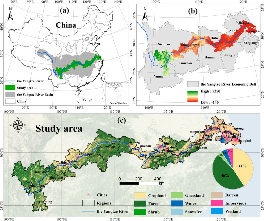
Figure 2. Overview of the Study Area: (A) Geographic location of the study area; (B) Elevation of the study area; (C) Spatial pattern of different land use/cover in the study area.
2.2 Data sources and processing
To assess habitat quality, this study utilizes land use/land cover (LULC) data derived from China’s 30-meter annual China Land Cover Database (CLCD) dataset, developed by Professor Huang Xin’s research team (Yang and Huang, 2021), and obtained from the Zenodo platform (https://zenodo.org/records/8176941). The CLCD offers comprehensive land cover data spanning from 1985 to 2022 across China. With a spatial resolution of 30 m and an overall accuracy of 79.31%, verified by 5,463 independent test samples, the CLCD fulfills the precision criteria required for this study. For our analysis, we selected data from five specific years—1990, 2000, 2010, 2015, and 2019—spanning the past three decades.
Urbanization is a multidimensional process that includes complex social and spatial aspects. Numerous scholars have evaluated China’s urbanization across four dimensions: population urbanization, social urbanization, economic urbanization, and spatial urbanization (Tang et al., 2020; Wang et al., 2023b). Data pertaining to demographics, societal aspects, economic factors, and other essential metrics for assessing urbanization in this study were sourced from the China Statistical Yearbook, as well as the statistical annuals from various provinces and municipalities. Due to the alterations in statistical standards and methodologies pertaining to certain crucial index data since 2020, the timeframe for this study is set from 1990 to 2019. Liangshan and Enshi do not have yearbook statistical data. Building upon a comprehensive review of previous studies, this research selects 15 indicators across four dimensions to establish an evaluative framework for urban development in the study area (Table 1) (Rui et al., 2019; Jiang and Lu, 2020; Tang et al., 2022). In cases where specific data are unavailable in the statistical yearbooks, the average values of the preceding and subsequent years were used to replace the missing data.
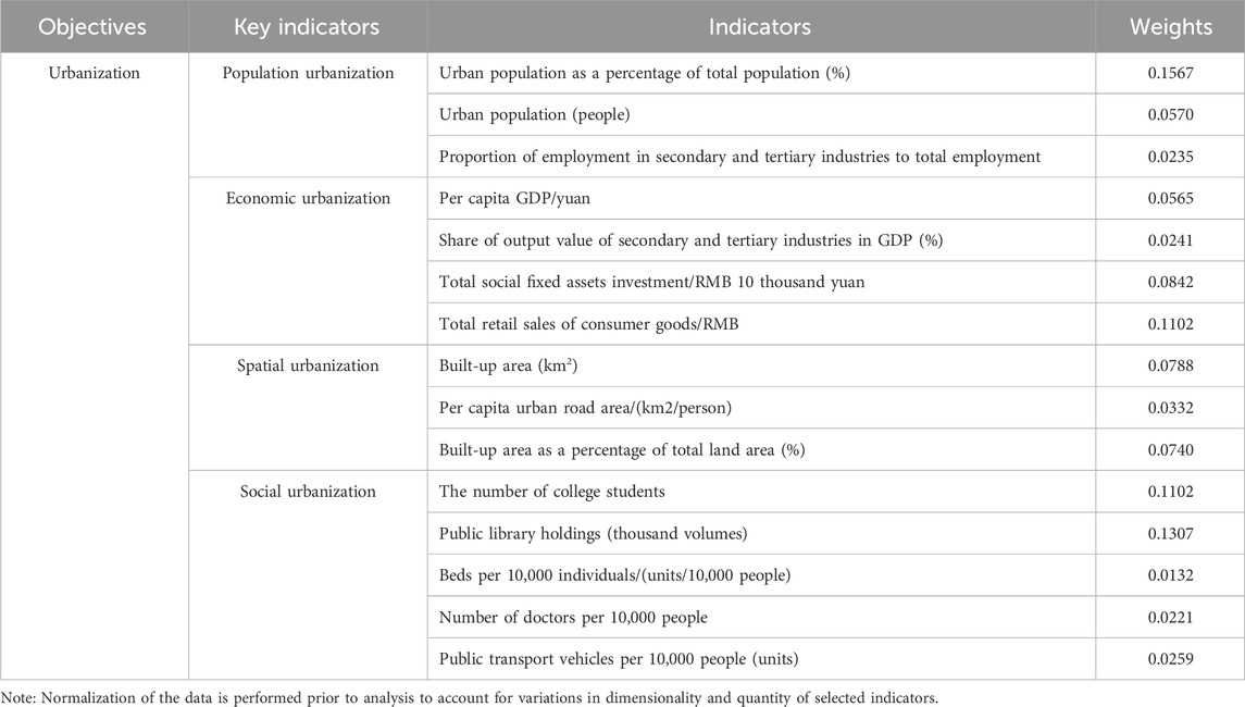
Table 1. Urbanization evaluation index system and weight.
2.3 Methods
2.3.1 Habitat quality calculation
The InVEST (Integrated Valuation of Ecosystem Services and Trade-offs) model is employed to evaluate ecosystem service functions and support ecosystem management and policy decisions. In this study, considering the specific conditions of the study area and prior research, impervious surfaces, cultivated lands, and bare lands are identified as sources that negatively impact habitat quality, whereas woodlands, scrublands, grasslands, and water bodies are recognized as high-quality habitat areas. This study, by incorporating the InVEST model manual, comparing calculation results for various maximum threat distances and weights, and reviewing prior research, identifies the relative weights, maximum impact distances, types of spatial decay, and habit at suitability associated with each threat factor (Bai et al., 2019; Wu L. et al., 2021; He et al., 2022; Hu et al., 2022).
We employ the Habitat Quality module of the InVEST model to compute the HQ index, which serves to gauge habitat quality. The index value ranges from 0 to 1, with higher values indicating better habitat quality. The primary calculation methods reference the model operation manual and the studies by Hu et al. and Chen et al., as summarized below (Hu et al., 2022; Chen and Liu, 2024) (see Equation 1):
Where,
2.3.2 The entropy method
In this research, the entropy method is applied to ascertain the weight of each indicator in the urbanization system. The calculation methods are based on the research by Wu et al., with the steps for determining the weights of each indicator outlined as follows (Wu and Yuan, 2018) (Equations 2–6):
Where:
2.3.3 Coupling coordination degree model (CCDM)
The coupling coordination degree model critically evaluates the interaction, collaboration, and synergistic enhancement among ecological and geospatial subsystems. This paper quantifies the extent of reciprocal influence and interaction between the urbanization level (U) and habitat quality index (Q) using a coupling degree index. The formulation of this index is cited according to Feng et al. (2021) (see Equation 7):
Here, U signifies the urbanization level index, Q the habitat quality index, and C the coupling degree, ranging from 0 to 1. Meanwhile, we utilized the CCDM, following the methodologies of Ma and Tang, to evaluate the coordinated development level between urbanization and habitat quality (Ma and Tang, 2022; Tang et al., 2022). The formula is as follows (see Equatons 8, 9):
Where T is the comprehensive development level of urbanization and habitat quality system, and
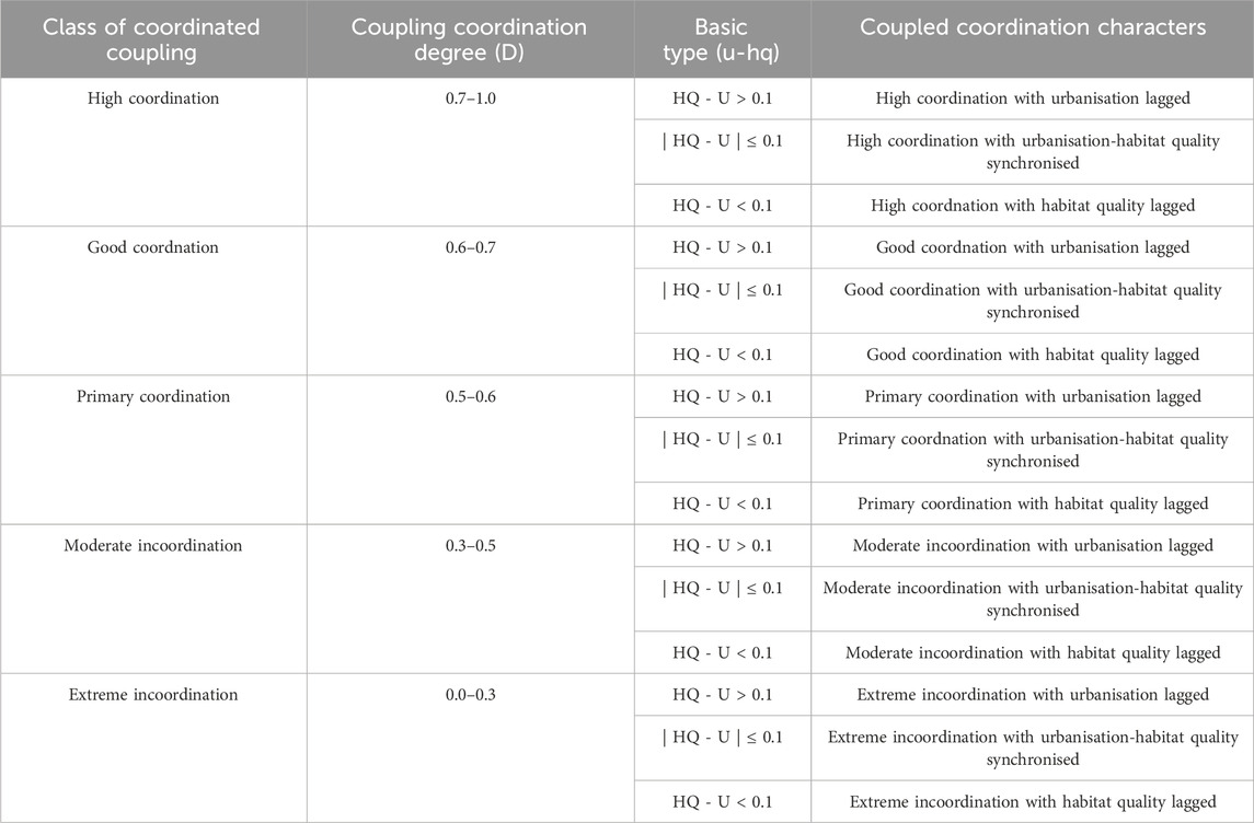
Table 2. Criteria for identifying coordinated coupling between urbanization (U) and habitat quality (HQ).
3 Results
3.1 Habitat quality characteristics
3.1.1 Spatial and temporal dynamics of habitat quality
Based on the prevailing conditions in the study area, habitat quality has been classified into four distinct levels according to specific criteria: poor (0–0.2), moderate (0.2–0.4), good (0.4–0.8), and excellent (0.8–1.0). The comprehensive level of habitat quality is favorable, but it exhibits a sustained declining trend. For the years 1990, 2000, 2010, 2015, and 2019, habitat quality averages in the research area were recorded at 0.5940, 0.5893, 0.5811, 0.5732, and 0.5675, correspondingly. Over the period from 1990 to 2019, there was a decrease of 4.5% in habitat quality. According to the classification criteria, the extent and percentage of various habitat quality categories within the research zone from 1990 to 2019 have been quantified and are detailed in Table 3. Predominantly, habitat quality within the examined area was categorized as “medium” and “excellent,” which, combined, represented more than 85% of the aggregate habitat quality. The area proportion of “poor” and “excellent” grades showed a gradual exhibited a gradual upward trend. Notably, the proportion of “poor” grades experienced a more pronounced increase, with a rise of 3.3%. This increase in proportion corresponded to a spatial expansion of 14584.4 km2. The area proportion of “medium” and “good” grades showed a continuous decreasing trend, and the “medium” showed a more prominent decreasing trend, decreasing by 3.5% and decreasing by 15696.7 km2. Therefore, the findings also reveal a decrease in general habitat quality across the study region, accompanied by a notable bifurcation in quality levels.
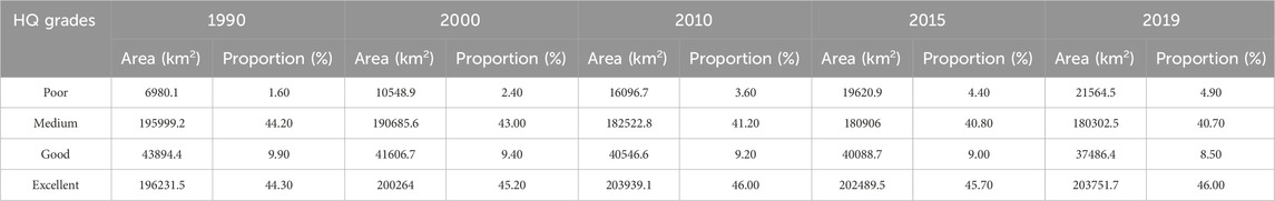
Table 3. Distribution and percentage of each habitat quality category from 1990 to 2019.
When examining habitat quality across 28 cities (Figure 3), it becomes evident that there are notable variations among the different urban areas. Yichang stands out with the highest habitat quality level, boasting an impressive average value of 0.7949. Following closely behind is Panzhihua with an average value of 0.7891. Shanghai, as the most urbanized area, shows the poorest habitat quality, averaging at 0.3075. In particular, its habitat quality average in 2019 was only 0.2641. For most cities, the average habitat quality values range between 0.4 and 0.7. Cities with habitat quality above the average, except for Chizhou and Anqing, are located in the middle and upper reaches of the Yangtze River. In contrast, those with below-average habitat quality, with the exception of Jingzhou, Wuhan, and Ezhou, are situated in the lower reaches of the Yangtze River.
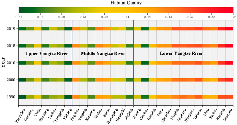
Figure 3. Habitat quality in cities within the study area from 1990 to 2019.
An analysis of the spatial distribution (Figure 4) reveals noticeable disparities in overall habitat quality across various regions. Areas with poorer habitat conditions are mainly found in urban centers like Shanghai, Nanjing, and Suzhou, as well as in many parts of cities along the lower Yangtze River. Buffer zones at the extremities show reduced habitat quality as well. Areas categorized as having ‘good’ or ‘excellent’ habitat quality are primarily located along the upper Yangtze River and in regions farther from the river within its middle reaches.
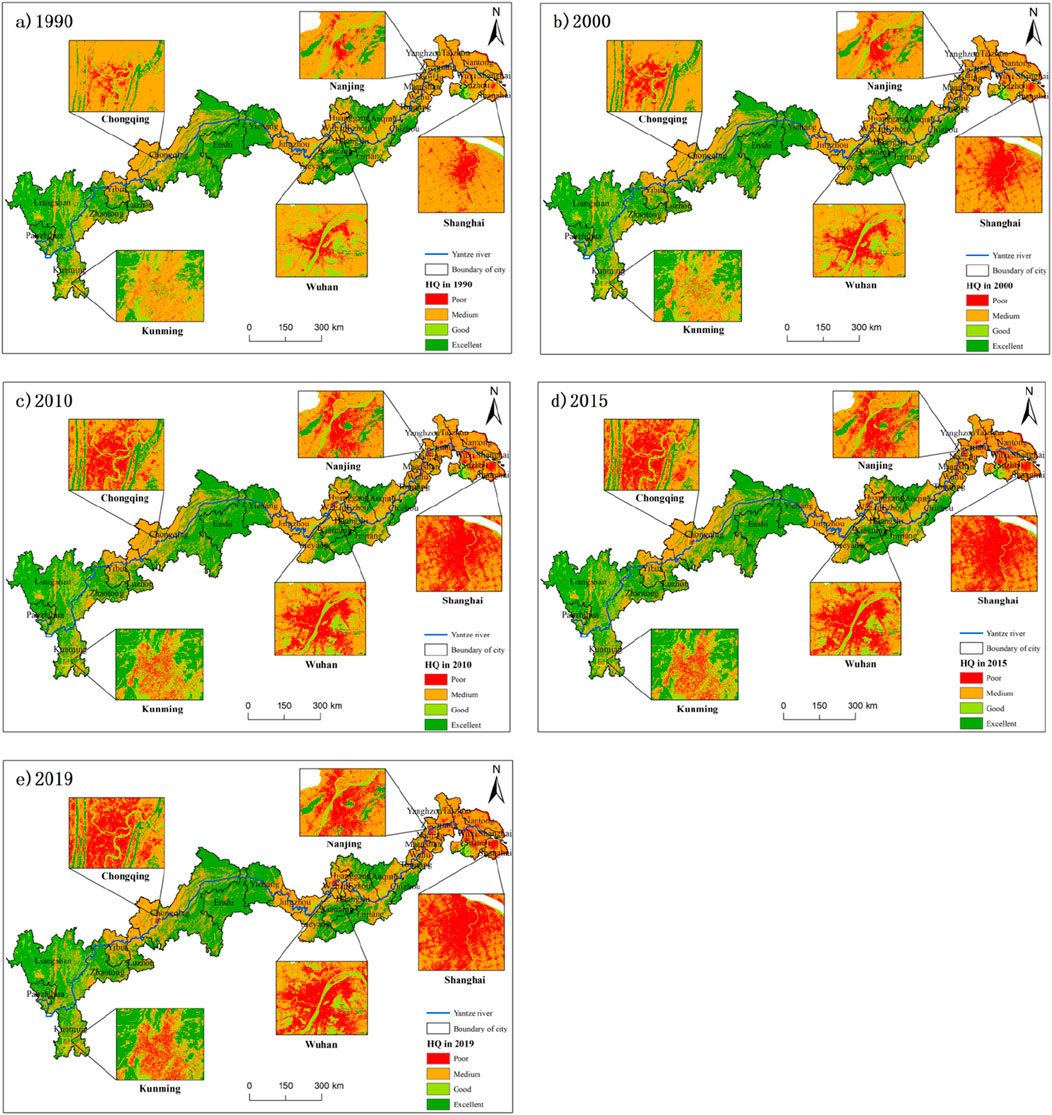
Figure 4. Spatial distribution of habitat quality levels. (A) 1990; (B) 2000; (C) 2010; (D) 2015; (E) 2019.
3.1.2 Changes in habitat quality structure
Within the examined region, a significant portion, amounting to 83.8% or 371154.7 km2, preserved a consistent level of habitat quality. The remaining 16.2%, or 71,950.5 km2, experienced changes in habitat quality grade. Specifically, 7.5% shifted from a “high” to a “low” classification, indicating a deterioration in habitat quality, while 7.4% moved from “low” to “high”, signifying an improvement in habitat quality. From 1990 to 2000 (Figure 5A), a total of 18.7% of the study region displayed alterations, with the principal shifts being from “medium” to “excellent” and vice versa, constituting 2.4% and 2.3% of the entire area, respectively. Between 2000 and 2010 (Figure 5B), the percentage of areas with stable habitat quality closely resembled that of the previous decade. The most notable change was a 2.4% shift in the total area from “medium” to “excellent” habitat quality. Other changed habitat quality categories accounted for less than 2.0%. From 2010 to 2019 (Figure 5E), the most notable change was the shift from “excellent” to “medium” habitat quality, encompassing 2.6% of the territory, indicating a deterioration in habitat quality due to escalated urban expansion.
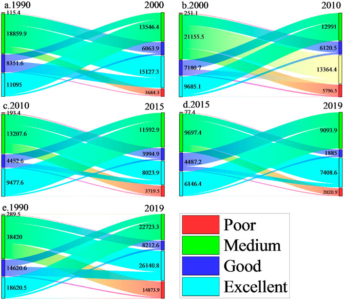
Figure 5. Changes and transitions in habitat quality grade area (km2) (A) from 1990 to 2000; (B) from 2000 to 2010; (C) from 2010 to 2015; (D) from 2015 to 2019; (E) from 1990 to 2019.
The analysis of habitat quality changes, as depicted in Figure 6, indicates that areas with declining habitat quality are predominantly located in major urban centers. These include Shanghai, Suzhou, Nanjing, Wuhan, and Chongqing, along with cities situated along the course of the Yangtze River such as Yangzhou, Wuhu, Jiujiang, Yichang, and Panzhihua. In contrast, signs of habitat quality improvement are distributed throughout the study area. Significantly, there is an increased occurrence of such enhancements in the vicinity of Ma’anshan and along the middle to upper segments of the Yangtze River.

Figure 6. Habitat quality variations from 1990 to 2019.
3.2 Dynamics of urbanization levels
3.2.1 Analysis of overall urbanization level
Figure 7 illustrates the urbanization rates for 28 cities for the years 1990, 2000, 2010, 2015, and 2019. From 1990 to 2019, the urbanization levels of these cities have steadily increased, with the mean urbanization rate in the study region escalating However, there are significant disparities in urbanization levels among different cities. Shanghai has seen the quickest expansion, holding the highest urbanization rate, which surged from 0.160 to 0.795. Conversely, Zhaotong demonstrates the minimal urbanization level, rising from 0.010 to 0.109.

Figure 7. Urbanization level of cities from 1990 to 2019.
In 1990, urban centers flanking the Yangtze River were just beginning to expand rapidly, starting from a relatively low base of urbanization. By the year 2000, there was a marked rise in urbanization across the region, notably in Shanghai, Nanjing, Wuhan, and Chongqing, which witnessed the most substantial surges. By 2010, urbanization levels in each city had steadily risen, although differences between cities were apparent. By 2019, every city within the study zone had an urbanization rate above 0.1, with cities such as Suzhou, Wuhan, and Chongqing surpassing 0.5, and Nanjing and Shanghai exceeding 0.6.
3.2.2 Analysis of urbanization level characteristics of the four subsystems
Overall, the urbanization level of the various subsystems in the 28 cities demonstrates a consistent upward trend. However, it should be emphasized that significant disparities exist across the various cities within the four subsystems. In terms of population urbanization level, all cities within the study zone saw a marked rise in urbanization from 1990 to 2000, mong which Chongqing, Shanghai and other cities increased the most significantly (Figure 8A). Post-2010, the rate of population urbanization began to stabilize. The urbanization levels across the three subsystems—economic, spatial, and social—showed a consistent upward trend and experienced changes. The overall trend of change in these subsystems was similar across cities (Figure 8). However, variations were observed among cities at different time points. Notably, Shanghai, Nanjing, Wuhan, and Chongqing, Suzhou demonstrated the highest levels. The urbanization levels of Zhaotong, Chizhou, Yibin and Tongling are observed to be the lowest.
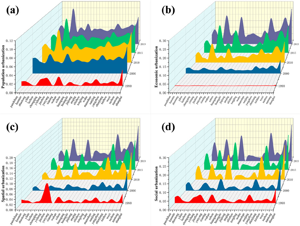
Figure 8. Urbanization levels of subsystems in 28 cities from 1990 to 2019. (A) Population urbanization; (B) Economic urbanization; (C) Spatial urbanization; (D) Social urbanization.
3.3 The coupling coordination degree between urbanization and habitat quality
3.3.1 Analysis of spatio-temporal characteristics in coupling and coordination
Analysis of the data in Figure 9 reveals synchronized urban development across all cities from 1990 to 2019, showing a consistent trend of enhanced synergy between urbanization and habitat quality. The coupling coordination degree increased from 0.380 to 0.604, despite some variability among cities. From 1990 to 2000 (Figures 9A, B), significant progress in coupling coordination aligned with population urbanization trends, highlighting its critical role. Between 2000 and 2010 (Figures 9B, C), most cities saw improvement, with Chongqing showing the most substantial increase, moving from basic to high coordination. During 2010 to 2019 (Figures 9C, E), all cities experienced a gradual increase in coupling coordination, leading to overall stabilization. Chongqing, Kunming, and Wuhan reached the highest coordination levels, while Ezhou had the lowest, reflecting a foundational level of coordination.
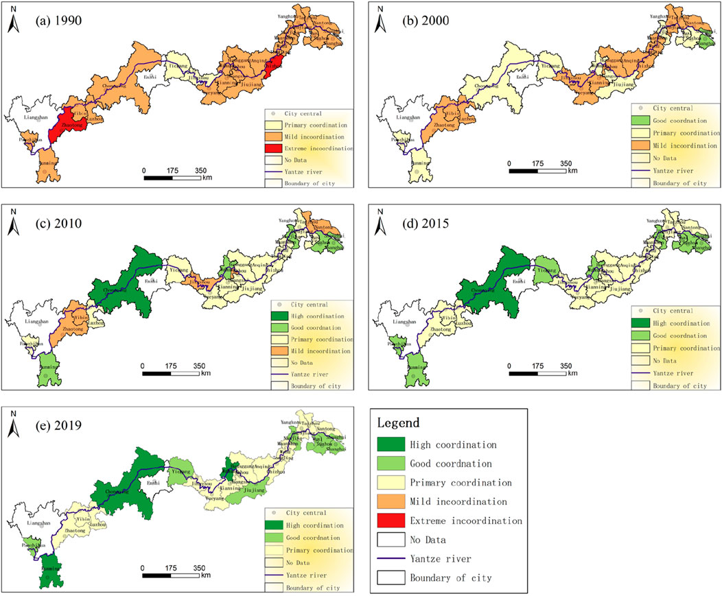
Figure 9. Urbanization-habitat quality coupling coordination trends (1990–2019) (A) 1990; (B) 2000; (C) 2010; (D) 2015; (E) 2019.
The coupling coordination degree (CCD) between the four urbanization subsystems and habitat quality has shown a significant overall improvement over the past 30 years, indicating a gradual enhancement in the coordination between these subsystems and habitat quality during the urbanization process (Figure 10). Among these, the CCD values for the economic and social subsystems have increased most significantly, reflecting a notable optimization in the relationship between urbanization and habitat quality in these areas. In contrast, the spatial subsystem exhibited more fluctuation in its CCD values, highlighting the more complex challenges cities face in balancing spatial expansion with habitat quality. Despite these differences, cities have generally achieved higher levels of coordination between urbanization and habitat quality.
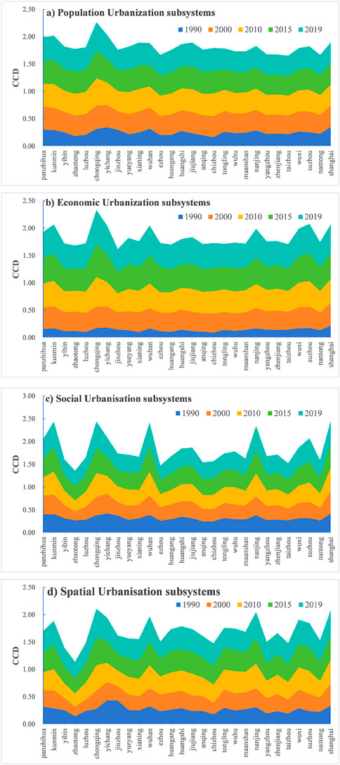
Figure 10. Coupling coordination degree between urbanization subsystems and habitat quality in the 28 cities (CCD, Coupling coordination degree; (A) Population urbanisation subsystems; (B) Economic urbanisation subsystems; (C) Social urbanisation subsystems; (D) Spatial urbanisation subsystems).
3.3.2 The coupling coordination degree characteristics between urbanization and habitat quality
To thoroughly investigate the characteristics of coupling coordination between urbanization and habitat quality, we applied the classification criteria from Table 2 along with the calculated features of coupling coordination. The findings, as illustrated in Figure 11, reveal a general transition in the coupling coordination characteristics across the study area, moving from an urbanization lag type to a synchronized urbanization-habitat quality type, and eventually to a habitat quality lag type. Initially, in 1990 (Figure 11A), urbanization lag was prevalent across all cities, with Zhaotong and Chizhou significantly uncoordinated, reflecting China’s early urbanization phase and limited anthropogenic impact on the Yangtze River Basin. By 2000 (Figure 11B), despite a dominant urbanization lag, coordination levels had improved, with Shanghai achieving synchronicity between urbanization and habitat quality. The year 2010 saw intensified human activity impacting habitat quality, prompting cities like Nanjing and Wuhan to evolve towards synchronization, whereas Chongqing attained high coordination (Figure 11C). By 2019 (Figure 11E), the pronounced increase in urbanization intensified its impact on habitat quality, yet a more synchronized urbanization-habitat quality relationship developed, with cities like Shanghai, Nanjing, Wuhan, Suzhou, Wuxi, and Chongqing indicating a shift towards balanced dynamics.
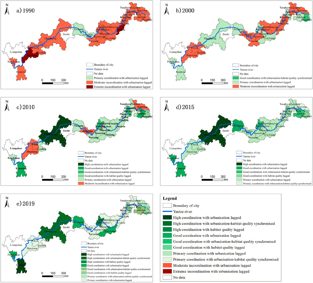
Figure 11. Characteristics of coupling coordination degree between urbanization and habitat quality from 1990 to 2019. (A) 1990; (B) 2000; (C) 2010; (D) 2015; (E) 2019.
3.3.3 Relationship between urbanization level and habitat quality
Within the study area, a significant spatial differentiation pattern is observed, marked by a clear negative correlation between habitat quality and urbanization levels. Specifically, habitat quality and urbanization levels display distinct patterns, highlighted by extreme values in provincial capital cities and gradient shifts along the Yangtze River, from the upper to the lower reaches (Figure 12). Habitat quality demonstrates a trend where provincial capital cities are low-value areas, and the upper reaches of the Yangtze River (average value of 0.713) > the middle reaches (average value of 0.592) > the lower reaches (average value of 0.465). In contrast, urbanization levels peak in provincial capital cities and exhibit an overall upward trend from the upper to lower reaches of the river.
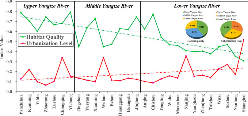
Figure 12. Average urbanization level, habitat quality and coupling coordination degree of cities along the Yangtze River.
4 Discussion
4.1 Comparison of the research results on the relationship between urbanization and habitat quality
Previous studies have shown that although urbanization has brought about economic prosperity and social progress, it has also had negative impacts on ecosystem services, biodiversity, and habitat quality (Kendal, 2023; Soni et al., 2024). This study finds that the rapid urbanization of cities along the Yangtze River has led to a decline in regional habitat quality, with 22 out of the 28 cities in the study area showing a downward trend in habitat quality. A significant negative correlation exists between urbanization levels and habitat quality, aligning with previous studies that consistently show urbanization contributes to regional habitat quality degradation (Ke et al., 2023; Chen and Liu, 2024). This degradation is primarily due to the expansion of urban construction land at the expense of highly suitable habitats such as forests, water bodies, and agricultural land, resulting in an overall decline in habitat quality. Moreover, this study observes that the coupling coordination between urbanization and habitat quality has gradually shifted from an urbanization-lagged type to a synchronous type and then to a habitat quality-lagged type, which aligns closely with related research findings (Luo et al., 2022; Tang et al., 2022). Additionally, relevant research indicates that effective ecological protection measures can alleviate the adverse effects of urbanization on habitat quality to some extent, promoting harmonious development between urbanization, the ecological environment, and habitat quality, which aligns with the main conclusions of this study (Tu et al., 2023; Huang et al., 2024).
4.2 Urbanization and habitat quality can achieve coupling and coordinated development
Analysis of the data shown in Figure 13 reveals a continuous rise in urbanization over the preceding three decades. This increment has catalyzed a shift in the interrelation of urbanization and habitat quality across the 28 cities assessed, transitioning from a state of discoordination to one of coordination. In particular, there has been a progression in the coupling coordination degree, transitioning from a phase of discoordination to one of coordination. Moreover, cities with higher urbanization levels tend to exhibit higher degrees of coupling coordination. This suggests that as urbanization increases, it is possible to achieve coordinated development with regional habitat quality. While urban growth impacts habitat quality, research shows that a synergistic relationship between urbanization and environmental conservation can be realized through the implementation of ecological protection measures (Luo et al., 2019; Huang et al., 2024). In the initial years of the 1990s, China commenced critical environmental conservation measures such as the Natural Forest Protection Project and the Grain for Green Program. Subsequently, the nation put forth the “Two Mountains” theory and advanced the concept of promoting ecological civilization construction. In 2016, strategic initiatives were focused on prioritizing the Yangtze River’s ecological rehabilitation, endorsing a comprehensive approach to conservation that outweighs unchecked development, and pursuing a course rooted in ecological primacy and green growth. Actions were taken to bolster ecological conservation (Pan and Dong, 2022). As urban areas expanded and efforts to foster an ecological civilization grew, public engagement with environmental protection also surged. These strategies have been instrumental in steering the coordinated evolution of urbanization and environmental sustainability.
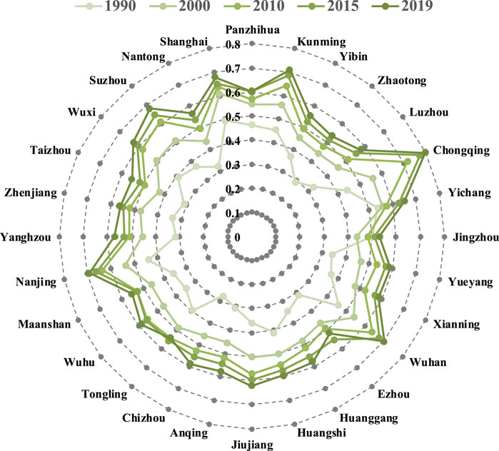
Figure 13. Characteristic values of coupling coordination between urbanization and habitat quality from 1990 to 2019.
4.3 An ideal city for coupled and coordinated development of urbanization and habitat quality
Based on the criteria provided in Table 2, the ideal threshold for coupling coordination involves achieving a high level of coordination, especially in terms of synchronizing urbanization and habitat quality. Analyses indicate that Chongqing has exhibited an improvement in habitat quality, with a 3.0% enhancement observed over the last 30 years. Concurrently, the urbanization metric has significantly escalated, denoting an almost twelvefold surge (Wang X. et al., 2022). The degree of coupling coordination has improved from a moderately uncoordinated level to a state of high coordination, as depicted in Figure 14 (Note: Image is sourced from the internet). Chongqing emerges as the unique case among the 28 cities analyzed, achieving significant synchronization between urban development and habitat quality. This positions it as a prime model for the integrated progression of both urbanization and habitat quality metrics. This accomplishment is intricately connected to the assortment of policies and measures that have been put into place in Chongqing over the course of the past three decades. Since becoming a directly-controlled municipality in 1997, Chongqing has undergone significant urban development, becoming a key economic center in the upper Yangtze River region (Jin Xiao-bin et al., 2024). It plays a vital role in maintaining the ecological wellbeing of not only the upper stretches but also the middle and downstream areas of the river (Li et al., 2013; Zhang et al., 2022). The national government and the municipal government of Chongqing have implemented a series of ecological measures, beginning with the Yangtze River basin shelter forest system in 1989, incorporating the “Three Gorges Project” ecological techniques into priority areas in 2006, and issuing guidelines for afforestation along the Yangtze in 2018. These measures have significantly contributed to Chongqing’s ecological improvements and have been crucial in sustaining habitat quality amidst ongoing urbanization.
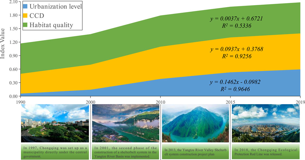
Figure 14. Habitat quality, urbanization level, coupling coordination degree, and ecological protection policies in Chongqing.
5 Conclusion
Urbanization significantly alters land use, profoundly impacting regional habitat quality. Understanding this relationship is crucial for safeguarding the ecological environment and promoting sustainable urban development. This study utilized the InVEST model, entropy method, and CCDM to reveal the spatiotemporal characteristics of urbanization and habitat quality in cities along the Yangtze River. It analyzed the evolution of the coupling coordination between the two, and discussed their interrelationship and coupling coordination characteristics, leading to the following main conclusions. From 1990 to 2019, habitat quality in the study area showed a general decline of 4.5%, with 16.2% of the region experiencing significant shifts, primarily in major cities. During the same period, urbanization levels across the 28 cities increased more than sixfold, with significant disparities—Shanghai exhibited the highest urbanization, while Zhaotong had the lowest. Although most cities showed an inverse relationship between urbanization and habitat quality, Chongqing, Kunming, and Zhaotong exhibited a positive correlation. The coupling coordination between urbanization and habitat quality evolved from an urbanization-lagged type to synchronization, and eventually to a habitat quality-lagged type. The coordination degree steadily improved across all cities, with Chongqing achieving the highest and Ezhou the lowest.
These findings underscore the importance of coordinated urban development and ecological protection, providing scientific basis and decision-making references for sustainable urban development along the Yangtze River. However, there are still limitations and areas for further research in this study. For example, although the study selects 15 indicators to comprehensively reflect the level of regional urbanization, to more fully and objectively represent regional urbanization levels, additional objective monitoring data (such as nighttime lights, urban expansion indices, and other remote sensing data) should be included. Furthermore, the land use data used to calculate habitat quality, though high-resolution at 30 m, employs primary classification, which can obscure more detailed content. The next step will involve using more detailed secondary classification land use data. Additionally, the sensitivity and threat tables used in the habitat quality calculations primarily rely on existing research and expert experience. Due to the lack of field verification, the parameters have some subjectivity and uncertainty. In subsequent studies, combining field survey data will allow for more accurate habitat quality predictions. Finally, future steps could include using geographic detectors and machine learning models to more deeply study the relationship between habitat quality and urbanization.
Data availability statement
The original contributions presented in the study are included in the article/supplementary material, further inquiries can be directed to the corresponding author.
Author contributions
JW: Writing–original draft, Conceptualization, Data curation, Methodology, Software. ZG: Conceptualization, Supervision, Writing–review and editing. GL: Writing–review and editing. FZ: Methodology, Supervision, Writing–review and editing. JC: Methodology, Software, Writing–original draft. WL: Investigation, Methodology, Writing–review and editing. QC: Investigation, Methodology, Writing–original draft. JL: Investigation, Software, Writing–review and editing. GC: Investigation, Software, Writing–original draft.
Funding
The author(s) declare that financial support was received for the research, authorship, and/or publication of this article. This research was supported by the Guizhou Provincial Key Technology R&D Program (No. [2023]226 and No. [2023]222); Engineering Research Center of colleges and universities of Guizhou Province (No. [2023]039); Digital Village Innovation Team of Higher Education Institutions in Guizhou Province (No. [2023]076); Key project of National Social Science Foundation of China (Grant No. 20AJY005); and Guizhou Provincial Department of Education youth project (No. [2022]257).
Conflict of interest
The authors declare that the research was conducted in the absence of any commercial or financial relationships that could be construed as a potential conflict of interest.
Publisher’s note
All claims expressed in this article are solely those of the authors and do not necessarily represent those of their affiliated organizations, or those of the publisher, the editors and the reviewers. Any product that may be evaluated in this article, or claim that may be made by its manufacturer, is not guaranteed or endorsed by the publisher.
References
Bai, L., Xiu, C., Feng, X., and Liu, D. (2019). Influence of urbanization on regional habitat quality: a case study of changchun city. Habitat Int. 93, 102042. doi:10.1016/j.habitatint.2019.102042
Bai, X., C, R., and Al, C. J. E. (2023). Methods, progress and prospect for diagnosis of karst ecosystem health in China—an overview. Chin. Sci. Bull. 19 (2023), 19–68. doi:10.1360/TB-2022-1174
Chen, D., Jiang, P., and Li, M. (2021). Assessing potential ecosystem service dynamics driven by urbanization in the yangtze river economic belt, China. J. Environ. Manag. 292, 112734. doi:10.1016/j.jenvman.2021.112734
Chen, S., and Liu, X. (2024). Spatio-temporal variations of habitat quality and its driving factors in the yangtze river delta region of China. Glob. Ecol. Conservation 52, e02978. doi:10.1016/j.gecco.2024.e02978
Feng, Y., He, S., and Li, G. (2021). Interaction between urbanization and the eco-environment in the pan-third pole region. Sci. Total Environ. 789, 148011. doi:10.1016/j.scitotenv.2021.148011
He, J., Wang, S., Liu, Y., Ma, H., and Liu, Q. (2017). Examining the relationship between urbanization and the eco-environment using a coupling analysis: case study of shanghai, China. Ecol. Indic. 77, 185–193. doi:10.1016/j.ecolind.2017.01.017
He, Y., Mo, Y., and Ma, J. (2022). Spatio-temporal evolution and influence mechanism of habitat quality in guilin city, China. Int. J. Environ. Res. Public Health 20, 748. doi:10.3390/ijerph20010748
Hongrui, W., Siyang, H., and Daoqing, Q. (2017). Discussion on related issues of drought and water shortage. Water Resour. Prot. doi:10.3880/j.issn.1004-6933.2017.05.001
Hu, J., Zhang, J., and Li, Y. (2022). Exploring the spatial and temporal driving mechanisms of landscape patterns on habitat quality in a city undergoing rapid urbanization based on gtwr and mgwr: the case of nanjing, China. Ecol. Indic. 143, 109333. doi:10.1016/j.ecolind.2022.109333
Huang, H., Xiao, Y., Huang, H., and Xiang, X. (2024). Coupling coordination of urbanization with ecological environment and influencing factors in loess plateau of China. Environ. Sci. Pollut. Res. 31, 38428–38447. doi:10.1007/s11356-024-33697-w
Jiang, X., and Lu, X. H. (2020). Temporal and spatial characteristics of coupling and coordination degree between urbanization and human settlement of urban agglomerations in the middle reaches of the yangtze river. China Land Sci. 34, 25–33. doi:10.11994/zgtdkx.20200107.143707
Jiang, X., Sun, Y., Qu, Y., Zeng, H., Yang, J., Zhang, K., et al. (2023). The development and future frontiers of global ecological restoration projects in the twenty-first century: a systematic review based on scientometrics. Environ. Sci. Pollut. Res. 30, 32230–32245. doi:10.1007/s11356-023-25615-3
Jin Xiao-bin, Y. C. Y. W., Ye, C., Yue, W. z., Ma, L. b., Luo, Z. d., Yang, R., et al. (2024). Urban-rural integrated development in China in the new era: challenges and paths. J. Nat. Resour. 39, 1. doi:10.31497/zrzyxb.20240101
Ke, X., Min, Y., Guo, H., Wang, D., and Mougharbel, A. (2023). What impact does the new urbanization in China’s yangtze river economic belt have on the ecological environment? Environ. Dev. Sustain., 1–20. doi:10.1007/s10668-023-03749-1
Kendal, D. (2023). Enrich urban biodiversity for sustainable cities. Nature 621, 691. doi:10.1038/d41586-023-03020-7
Leung, B., and Gonzalez, A. (2024). Global monitoring for biodiversity: uncertainty, risk, and power analyses to support trend change detection. Sci. Adv. 10, j1448. doi:10.1126/sciadv.adj1448
Li, L., and Liu, Y. (2019). Spatial-temporal patterns and driving forces of sustainable urbanization in China since 2000. J. Urban Plan. Dev. 145, 5019014. doi:10.1061/(ASCE)UP.1943-5444.0000528
Li, Y., Liu, C., Min, J., Wang, C., Zhang, H., and Wang, Y. (2013). RS/GIS-based integrated evaluation of the ecosystem services of the Three Gorges Reservoir area (Chongqing section). Acta Ecol. Sin. 33, 168–178. doi:10.5846/stxb201107020989
Lin, Y., Zhang, X., Zhu, H., and Li, R. (2024). Spatiotemporal evolution and mechanisms of habitat quality in nature reserve land: a case study of 18 nature reserves in hubei province. Land 13, 363. doi:10.3390/land13030363
Liu, Z., Liu, Z., Zhou, Y., and Huang, Q. (2022). Distinguishing the impacts of rapid urbanization on ecosystem service trade-offs and synergies: a case study of shenzhen, China. Remote Sens. 14, 4604. doi:10.3390/rs14184604
Luo, Q., Luo, L., Zhou, Q., and Song, Y. (2019). Does China's yangtze river economic belt policy impact on local ecosystem services? Sci. Total Environ. 676, 231–241. doi:10.1016/j.scitotenv.2019.04.135
Luo, Q., Zhou, J., Zhang, Y., Yu, B., and Zhu, Z. (2022). What is the spatiotemporal relationship between urbanization and ecosystem services? A case from 110 cities in the yangtze river economic belt, China. J. Environ. Manag. 321, 115709. doi:10.1016/j.jenvman.2022.115709
Lyu, R., Zhang, J., Xu, M., and Li, J. (2018). Impacts of urbanization on ecosystem services and their temporal relations: a case study in northern ningxia, China. Land Use Policy 77, 163–173. doi:10.1016/j.landusepol.2018.05.022
Ma, M., and Tang, J. (2022). Interactive coercive relationship and spatio-temporal coupling coordination degree between tourism urbanization and eco-environment: a case study in western China. Ecol. Indic. 142, 109149. doi:10.1016/j.ecolind.2022.109149
Mahecha, M. D., Bastos, A., Bohn, F. J., Eisenhauer, N., Feilhauer, H., Hartmann, H., et al. (2022). Biodiversity loss and climate extremes—study the feedbacks. Nature 612, 30–32. doi:10.1038/d41586-022-04152-y
Mondal, I., Naskar, P. K., Alsulamy, S., Jose, F., Hossain, S. A., Mohammad, L., et al. (2024). Habitat quality and degradation change analysis for the sundarbans mangrove forest using invest habitat quality model and machine learning. Environ. Dev. Sustain., 1–26. doi:10.1007/s10668-024-05257-2
National Bureau of Statistics of China (2018). China Statistical Yearbook 2018. Beijing: China Statistics Press. Available at: https://www.stats.gov.cn/sj/ndsj/2018/indexeh.htm.
Ning, Y., Liu, S., Zhao, S., Liu, M., Gao, H., and Gong, P. (2022). Urban growth rates, trajectories, and multi-dimensional disparities in China. Cities 126, 103717. doi:10.1016/j.cities.2022.103717
Ouyang, X., Tang, L., Wei, X., and Li, Y. (2021). Spatial interaction between urbanization and ecosystem services in Chinese urban agglomerations. Land Use Policy 109, 105587. doi:10.1016/j.landusepol.2021.105587
Pan, Y., and Dong, F. (2022). Dynamic evolution and driving factors of new energy development: fresh evidence from China. Technol. Forecast. Soc. Change 176, 121475. doi:10.1016/j.techfore.2022.121475
Qiao, Q., Zhen, Z., Liu, L., and Luo, P. (2023). The construction of ecological security pattern under rapid urbanization in the loess plateau: a case study of taiyuan city. Remote Sens. 15, 1523. doi:10.3390/rs15061523
Ren, Q., He, C., Huang, Q., Zhang, D., Shi, P., and Lu, W. (2023). Impacts of global urban expansion on natural habitats undermine the 2050 vision for biodiversity. Resour. Conservation Recycl. 190, 106834. doi:10.1016/j.resconrec.2022.106834
Rui, X., Meng, L., Xufeng, F., et al. (2019). Exploring the interactive coercing relationship between urbanization and ecosystem service value in the shanghai–hangzhou bay metropolitan region. J. Clean. Prod. 253. doi:10.1016/j.jclepro.2019.119803
Song, S., Liu, Z., He, C., and Lu, W. (2020). Evaluating the effects of urban expansion on natural habitat quality by coupling localized shared socioeconomic pathways and the land use scenario dynamics-urban model. Ecol. Indic. 112, 106071. doi:10.1016/j.ecolind.2020.106071
Soni, H., Yadav, R. K., and Patra, S. K. (2024). Global impact of urbanization on ecosystems: a comprehensive bibliometric analysis. Nat. Hazards Res. doi:10.1016/j.nhres.2024.04.001
Stephens, T. (2023). The kunming--montreal global biodiversity framework. Int. Leg. Mater. 62, 868–887. doi:10.1017/ilm.2023.16
Sun, Y., Jiao, L., Guo, Y., and Xu, Z. (2024). Recognizing urban shrinkage and growth patterns from a global perspective. Appl. Geogr. 166, 103247. doi:10.1016/j.apgeog.2024.103247
Tang, F., Fu, M., Wang, L., and Zhang, P. (2020). Land-use change in changli county, China: predicting its spatio-temporal evolution in habitat quality. Ecol. Indic. 117, 106719. doi:10.1016/j.ecolind.2020.106719
Tang, F., Wang, L., Guo, Y., Fu, M., Huang, N., Duan, W., et al. (2022). Spatio-temporal variation and coupling coordination relationship between urbanisation and habitat quality in the grand canal, China. Land Use Policy 117, 106119. doi:10.1016/j.landusepol.2022.106119
Tu, D., Cai, Y., and Liu, M. (2023). Coupling coordination analysis and spatiotemporal heterogeneity between ecosystem services and new-type urbanization: a case study of the yangtze river economic belt in China. Ecol. Indic. 154, 110535. doi:10.1016/j.ecolind.2023.110535
Wang, B., Oguchi, T., and Liang, X. (2023a). Evaluating future habitat quality responding to land use change under different city compaction scenarios in southern China. Cities 140, 104410. doi:10.1016/j.cities.2023.104410
Wang, F., Yuan, X., Zhou, L., and Zhang, M. (2022a). Integrating ecosystem services and landscape connectivity to construct and optimize ecological security patterns: a case study in the central urban area chongqing municipality, China. Environ. Sci. Pollut. Res. 29, 43138–43154. doi:10.1007/s11356-021-16281-4
Wang, K., Ma, H., and Fang, C. (2023b). The relationship evolution between urbanization and urban ecological resilience in the northern slope economic belt of tianshan mountains, China. Sustain. Cities Soc. 97, 104783. doi:10.1016/j.scs.2023.104783
Wang, L., Zhang, S., Xiong, Q., Liu, Y., Liu, Y., et al. (2022b). Spatiotemporal dynamics of cropland expansion and its driving factors in the yangtze river economic belt: a nuanced analysis at the county scale. Land Use Policy 119, 106168. doi:10.1016/j.landusepol.2022.106168
Wang, X., Su, F., Yan, F., Zhang, X., and Wang, X. (2022c). Effects of coastal urbanization on habitat quality: a case study in guangdong-Hong Kong-macao greater bay area. Land 12, 34. doi:10.3390/land12010034
Wu, J., Li, X., Luo, Y., and Zhang, D. (2021a). Spatiotemporal effects of urban sprawl on habitat quality in the pearl river delta from 1990 to 2018. Sci. Rep. 11, 13981. doi:10.1038/s41598-021-92916-3
Wu, L., Sun, C., and Fan, F. (2021b). Estimating the characteristic spatiotemporal variation in habitat quality using the invest model—a case study from guangdong--Hong Kong--Macao greater bay area. Remote Sens. 13, 1008. doi:10.3390/rs13051008
Wu, Y., and Yuan, J. (2018). Urbanization coordination development degree spatio evolution analysis in shaanxi province from 2000 to 2015. Econ. Geogr., 75–83. doi:10.15957/j.cnki.jjdl.2018.07.010
Xiao, R., Lin, M., Fei, X., Li, Y., Zhang, Z., and Meng, Q. (2020). Exploring the interactive coercing relationship between urbanization and ecosystem service value in the shanghai–hangzhou bay metropolitan region. J. Clean. Prod. 253, 119803. doi:10.1016/j.jclepro.2019.119803
Yang, H., Zhou, H., Deng, S., Zhou, X., and Nie, S. (2024). Spatiotemporal variation of ecosystem services value and its response to land use change in the yangtze river basin, China. Int. J. Environ. Res. 18, 17. doi:10.1007/s41742-024-00569-7
Yang, J., and Huang, X. (2021). The 30 m annual land cover dataset and its dynamics in China from 1990 to 2019. Earth Syst. Sci. Data 13, 3907–3925. doi:10.5194/essd-13-3907-2021
Zhang, T., Gao, Y., Li, C., Xie, Z., Chang, Y., and Zhang, B. (2020a). How human activity has changed the regional habitat quality in an eco-economic zone: evidence from poyang lake eco-economic zone, China. Int. J. Environ. Res. Public Health 17, 6253. doi:10.3390/ijerph17176253
Zhang, X., Song, W., Lang, Y., Feng, X., Yuan, Q., and Wang, J. (2020b). Land use changes in the coastal zone of China’s hebei province and the corresponding impacts on habitat quality. Land Use Policy 99, 104957. doi:10.1016/j.landusepol.2020.104957
Zhang, Z., Zhang, L., Liang, T., Cheng, L., Fang, L., Zhao, B., et al. (2022). Has the yangtze river economic belt strategy promoted the construction of ecological civilization in the upper reaches of the yangtze river? Front. Environ. Sci. 10, 1046323. doi:10.3389/fenvs.2022.1046323
Zhong, C., Guo, H., Swan, I., Gao, P., Yao, Q., and Li, H. (2023). Evaluating trends, profits, and risks of global cities in recent urban expansion for advancing sustainable development. Habitat Int. 138, 102869. doi:10.1016/j.habitatint.2023.102869
Keywords: urbanization, habitat quality, coupling coordination degree, sustainable development, the Yangtze river basin
Citation: Wu J, Guo Z, Luo G, Zhang F, Chen J, Li W, Chen Q, Liao J and Cao G (2024) Exploring the spatiotemporal dynamics and coupling coordination of urbanization and habitat quality in the Yangtze river basin, China. Front. Environ. Sci. 12:1435293. doi: 10.3389/fenvs.2024.1435293
Received: 21 May 2024; Accepted: 27 August 2024;
Published: 04 September 2024.
Edited by:
Diogo Guedes Vidal, University of Coimbra, PortugalReviewed by:
Maria Alzira Pimenta Dinis, Fernando Pessoa University, PortugalHélder Tiago Da Silva Lopes, University of Minho, Portugal
Copyright © 2024 Wu, Guo, Luo, Zhang, Chen, Li, Chen, Liao and Cao. This is an open-access article distributed under the terms of the Creative Commons Attribution License (CC BY). The use, distribution or reproduction in other forums is permitted, provided the original author(s) and the copyright owner(s) are credited and that the original publication in this journal is cited, in accordance with accepted academic practice. No use, distribution or reproduction is permitted which does not comply with these terms.
*Correspondence: Zhongyang Guo, enlndW9AZ2VvLmVjbnUuZWR1LmNu