 Hoonshin Jung1*
 Leland Moss1,2
 Tim J. B. Carruthers1
 Diana R. Di Leonardo1
 Kristin DeMarco3
 Marie Whalen4,5
 Michael Brasher6†
 Jasper Dijkstra7
- 1The Water Institute of the Gulf, Baton Rouge, LA, United States
- 2Abt Global, Baton Rouge, LA, United States
- 3School of Renewable Nature Resources, Louisiana State University, Baton Rouge, LA, United States
- 4Department of Earth and Environmental Sciences, Tulane University, New Orleans, LA, United States
- 5U.S. Coast Guard Research and Development Center, New London, CT, United States
- 6Ducks Unlimited, Inc., Gulf Coast Joint Venture, Lafayette, LA, United States
- 7Deltares, Delft, Netherlands
Marsh terraces, constructed as a restoration and protection strategy, consist of a series of earthen berms in open water areas of the coastal wetland landscape and are being implemented across the Louisiana coast. To assess the efficacy of the marsh terraces as a nature-based solution, a small-scale, high-resolution hydrodynamic model was developed based on field sampling of vegetation and physical parameters (water level, waves, sediment, turbidity, and terrace elevation). This study tested common marsh terrace designs (e.g., chevron, linear, box, T-shape, etc.), ultimately selecting a preferred design based on the evaluation of factors such as vegetation, water depth, and sediment type on terrace stability and sediment retention under calm and storm conditions. The model results revealed that the 100 m box and the chevron designs exhibited greatest terrace stability and sediment trapping, particularly when installed perpendicular to prevailing wind and waves. The preferred terrace design was the box design due to its higher modeled resilience to wind and waves from multiple directions. Vegetation presence enhanced terrace resistance to erosion, with variations depending on vegetation type. Higher vegetation biomass, especially during the summer, contributed to the greatest stability of terraces. Greater water depth between terraces led to increased sediment retention, and terraces predominantly composed of organic-rich mud demonstrated greater stability than those with higher proportions of sand. Overall, vegetation had the greatest impact on sediment retention in the terrace field compared to water depth and sediment type. However, the potential habitat for submerged aquatic vegetation (SAV) was more influenced by water depth (i.e., 0.1 m < depth <1 m) than shear stress (<0.5 Pa). Even under storm conditions, shear stress rarely determined potential habitat for SAV, as shear stress remained relatively low within the terrace field. Potential SAV habitat was most abundant in shallow areas and increased where sediment stability was lowest (i.e., no vegetation and sand), primarily due to eroded sediment increasing the shallow area. While this model was developed using field data specific to Louisiana marshes, it can be adapted as a tool for terrace restoration project design and planning in most coastal wetlands.
1 Introduction
Louisiana is leading efforts in addressing both the challenges of wetland loss (Couvillion et al., 2011; CPRA, 2017) and the implementation of coastal restoration and protection projects (Coastal Protection and Restoration Authority [CPRA] 2017). These projects provide insights and knowledge useful across the country and the world as coastal communities adapt to coastal change (IPCC, 2014). Louisiana has lost more than 480,000 ha of emergent marsh since 1932 (Couvillion et al., 2011) and could lose an additional 0.3–1 million ha over the next 50 years if no restoration action is taken (CPRA, 2017). CPRA is developing and implementing coastal restoration and protection through the implementation of the Louisiana Coastal Master Plan. It is estimated that with the projects included in the 2017 Coastal Master Plan 0.2 million hectares will be built or maintained over 50 years (CPRA, 2017).
The state of Louisiana has a wide variety of restoration actions, both planned and implemented, including sediment diversions, marsh creation with dredge material, vegetation planting, and building marsh terraces. This work focused on terraces, which are segmented earthen berms constructed in open water areas of coastal wetlands used for coastal restoration and protection. Terrace construction dredges sediment from the area immediately surrounding the intended location of the terrace, creating a trench surrounding newly created land. To avoid excessively deep trenches with steep sloping terraces, they are typically constructed in shallow water (<1 m). This is accomplished by either selecting a shallow area or by moving dredge material into the area first to reduce the water depth. Terraces are usually built to an elevation similar to the surrounding marsh to best integrate with natural processes and ecosystem functions (Brasher, 2016; Hymel and Breaux, 2012). Sediment in Louisiana marshes varies depending on factors such as how the wetland was created (natural vs. engineered) as well as its location (river deposits vs. isolated marsh). The longevity of the created earthen berms can be impacted by sediment types and the locations from which the external sediments are supplied (Osorio et al., 2020; Elsey-Quirk et al., 2019).
Terraces aid in slowing marsh erosion by reducing fetch and wave height, and in turn reduce the erosive effects of waves on adjacent land (Brasher, 2016; Castellanos and Aucoin, 2004; Steyer, 1993). In Louisiana, terraces are usually constructed in locations where marsh has converted to open water (Brasher, 2016), but can also be constructed in outflows from river diversions or created channels to trap sediment and more rapidly build land. Terraces increase marsh edge which creates habitat for a variety of fauna (e.g., birds, fish, etc.; Rozas and Minello, 2001; Rozas and Minello, 2007; O’Connell and Andrew Nyman, 2009). Terrace field designs also vary, but the influence of project design on physical and ecological benefits has received minimal attention (Osorio et al., 2020).
Emergent and submerged vegetation on and around the terraces can play a critical role in the primary and secondary benefits of the terrace, including impacting the terrace stability (Nepf and Ghisalberti, 2008; Kim et al., 2024; Xu et al., 2022; Vargas-Luna et al., 2015; Mudd et al., 2010). Both planted vegetation and other vegetation that recruits independently can have potential benefits to the restoration. Submerged aquatic vegetation (SAV) provides important faunal habitat in Louisiana marshes, but correlation between terrace construction and SAV varies greatly in the literature. Caldwell (2003) found that SAV was more common in natural marshes compared to terraces. Other research has found that SAV biomass and the frequency of its occurrence was similar between terraced marsh and natural marsh (Rozas and Minello, 2001; Castellanos and Aucoin, 2004; O’Connell and Andrew Nyman, 2009). Additionally, some researchers have observed an increase in SAV due to the presence of terrace projects (Cannaday, 2006; Thibodeaux and Guidry, 2009).
This work developed a numerical model of hydrodynamics and sediment transport to understand the impacts of physical processes such as storms on the efficacy and benefits of marsh terrace restoration. The first aim was to use the model to compare common terrace designs under different environmental conditions and identify the design with greatest potential for terrace stability and sediment trapping. The second aim was to use the preferred design to test the role of vegetation, water depth, and sediment type on terrace stability and sediment retention under storm conditions. The third aim was to estimate SAV potential habitat based on simulated water depth and shear stress at the sediment surface under storm conditions.
2 Materials and methods
2.1 Study sites
The first location studied was Bayou Monnaie, Galliano, Louisiana (see Figure 1A), where two terrace fields were examined (i.e., Phase I and Phase II). Construction of terraces at the Phase I site was completed in May 2017, while Phase II was completed in July 2018 (Ducks Unlimited, Personal Communication, 2018). The Phase I terraces at Bayou Monnaie consisted of box and non-uniform configurations (old terraces in Figure 1A). Terrace construction at the Phase II site included a combination of different designs (i.e., chevron, linear, and T-Shape; new terraces in Figure 1A), allowing for visualization and sampling of alternative designs. The second location included in this study was Bay Alexis, located on the Mississippi River Delta to the northeast of Venice, Louisiana (see Figure 1B), where 157 terraces were constructed in 2005 and destroyed shortly after construction by Hurricane Katrina. The terraces were re-built in 2016 to the east of the original location as proposed in Renne et al. (2011) to ensure there was adequate sediment for construction. Both terrace fields at Bay Alexis were built in the box configuration (Figure 1B). All terraces were planted with Spartina alterniflora (Brasher, 2016; Renne et al., 2011).
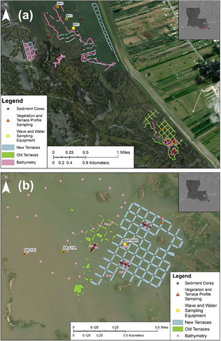
Figure 1. Study site. (A) Bayou Monnaie terraces, Phase I constructed in 2017 (old), Phase II constructed in 2018 (new). (B) Bay Alexis terraces, old constructed in 2005, new constructed in 2016.
2.2 Field data collection
For this study, field measurements were conducted for various abiotic and biotic parameters at the two terrace fields. Terrace dimensions including overall height, slope, and the subaerial to subaqueous transition was measured at both locations (see Figure 1) to characterize the physical features of the terraces. At the Bayou Monnaie study area, single beam bathymetry data were collected throughout the established and newly constructed terrace fields (Figure 1A). Several bathymetry transects were collected in each terrace type as well as in the larger open water lake. Depth in the Bay Alexis study area was less than 1 m, which was too shallow for a single beam survey. Bathymetry points in Bay Alexis were collected as single point measurements distributed across the bay using a survey pole mounted GPS (Figure 1B). At select terraces, cross section depth transects were taken across the inside of the terrace field (Figure 1B).
Hydrodynamic data such as water depth (= water surface elevation + mean water depth), current, wave height, and turbidity were also measured. This data was collected at three stations using a multiparameter water quality sonde (RBR Duo [hourly sampling] or YSI EXO2 [12-minute sample interval]) at each of the study locations. At one station in each study area, water current magnitude and direction was also measured using a Sontek ADV or Nortek Vector. To understand the sediment composition, sediment cores were sampled from terrace fields and analyzed in the lab for grain size distribution using a laser particle size analyzer and for organic content using loss on ignition. Detailed information on sediment analysis can be found in Supplementary Material.
The marsh vegetation field data collection at both locations (Figure 1) was conducted during winter or early spring (minimum vegetation biomass) and again in the middle of summer at peak growing season (maximum vegetation biomass). The vegetation parameters measured per plot were average plant height and vertically averaged vegetation diameter and density. The vertically averaged vegetation diameter was estimated by measuring the diameter of individual vegetation stems for different height categories (0–20 cm, 20–50 cm, 50–100 cm, 100–150 cm, 150–200 cm, and 200+ cm).
2.3 Model setup
2.3.1 Model and domain
To assess the impact of wave attenuation and sediment transport in the terrace sites, Delft3D (Version 4.02.03) was used with the incorporation of hydrodynamic (D-Flow), sediment transport and morphology (D-Morph), and wave (D-Waves) models. The numerical model is capable of predicting specific hydrodynamic and morphodynamic processes including water depth, currents, bottom shear stress induced by waves and current interaction, and erosion/deposition of sediment (Deltares 2014; Deltares, 2013). In particular, the model can simulate the effect of vegetation on attenuating current and waves by considering various vegetation characteristics (e.g., stem height and density). To account for vegetation effects, the trachytope approach formulated by Baptist et al. (2007) was used in D-Flow and D-Morph. In D-Waves, which is based on the spectral wave model SWAN (Simulating Waves Nearshore), mean values of vegetation characteristics were applied following the method of Mendez and Losada (2004). This approach was necessary because SWAN only allows the simulation of one type of vegetation and in this work online coupling was used between SWAN and D-Flow.
For this study, a hypothetical idealized model domain with high spatial resolution was designed based on field measurements (Figure 2A). Smaller grid cells were used near the terraces (5 × 5 m) with lower resolution toward the model boundary (40 × 40 m grid cells). The water depth at the open boundary was 3 m and water depth gradually decreased to 1 m at the exposed side of the terrace. The height and water depth inside the terrace fields were designed based on field measurements (Figure 2C). The model terrace heights were +0.5 m from NAVD88. Bottom elevation inside the terraces was defined as −1.0 m for the deep water area (representing the Bayou Monnaie area) and −0.5 m for the shallow water area (representing Bay Alexis). Although the modeled terraces were based on field measurements, for interpretation and broader application, terrace designs are referred to simply as deep and shallow rather than by the geographic location they were based upon.
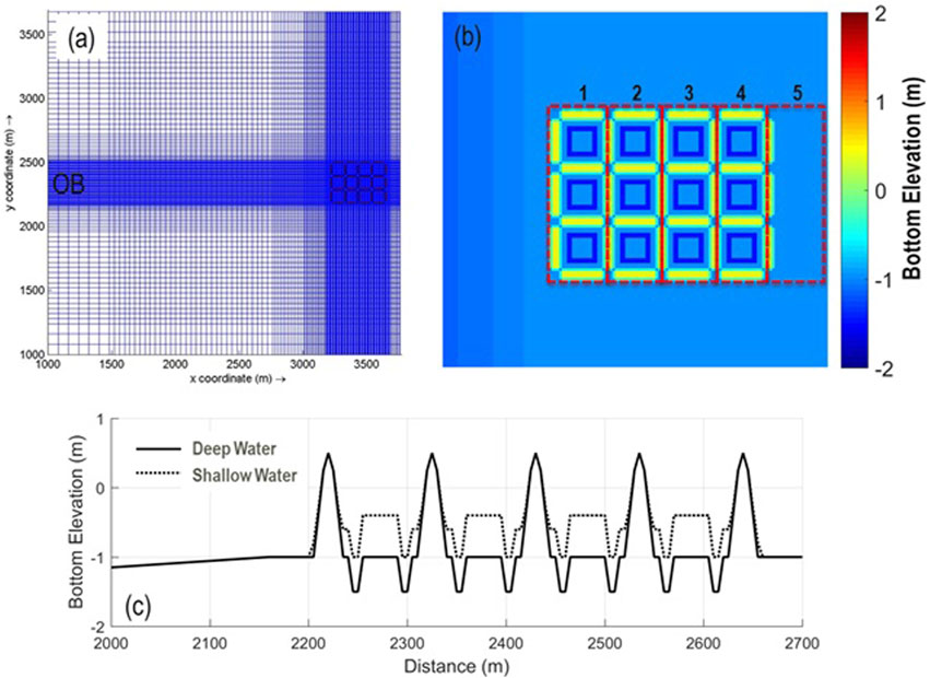
Figure 2. Computational model domain and example of terrace site: (A) model domain and grid, (B) top view of the box type terrace field and sections (red boxes) for net sedimentation calculations, (C) cross-section view showing bottom elevation variances between deep and shallow water areas. OB in (A) indicates the open boundary where tide and wave boundary conditions were defined.
2.3.2 Terrace types
To compare terrace design in terms of stability and sediment capture, five terrace designs commonly used in coastal Louisiana were tested. The five designs were chevrons with 100 m spacing (Chevron 100 m), chevrons with 200 m spacing (Chevron 200 m), linear, box, and T-shape (Figure 3). The lengths of the terraces and the spacing between them were determined from field measurements and geospatial satellite image measurements of known terrace fields.
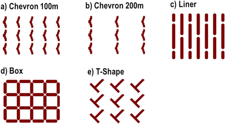
Figure 3. The five different arrangements used to assess terrace stability and capacity for sediment capture. Chevron 100 m refers to a chevron shaped terrace field with 100 m spacing. Chevron 200 m refers to a chevron shaped terrace field with 200 m spacing. Linear represents a linear shaped terrace field. Box refers to a square shaped terrace field. T-shape indicates a T-shaped terrace field.
The dimensions of the different terrace structures were obtained from the reference sites (Figure 1) except for the linear design where dimensions were taken from the Morganza Mitigation Terraces in Point Aux Chenes (U.S. Army Corps of Engineers, 2013), coastal Louisiana. Both Chevron 100 m and 200 m had a length of approximately 100 m, with only the spacing between them differing. For the linear type, the terrace length was 200 m, with a 50 m spacing between them. The box type had each side measuring 90 m. For the T-shape design, each side was 90 m long, and the spaces between the terraces varied from 110 m (shorter) to 200 m (longer). All terrace heights were established at +0.5 m NAVD88.
2.3.3 Model input parameters
2.3.3.1 Sediment composition of terraces
The sediment composition of the terraces at both Bayou Monnaie and Bay Alexis were very similar despite their different locations (Figure 4). Predominantly, the sediments consisted of mud (silt + clay) and organic matter, with a low proportion of sand (approximately 10%). In the model runs, four different sediment types were considered so as to assess the impact of sediment composition on terraces efficacy: organic marsh soil, sand, silt, and clay. Specifically for terraces, two sediment compositions were examined in this study: mud and sand. The “mud” composition, roughly based on field measurements from Bayou Monnaie, included 10% sand, 50% organic marsh soil, 30% silt, and 10% clay. Conversely, the “sand” composition, derived from literature values (Feher and Hester, 2018; Perry and Mendelssohn, 2009), comprised 50% sand, 10% organic marsh soil, 30% silt, and 10% clay. These two sediment compositions represent potential variations in sediment composition across Louisiana (Figure 4).
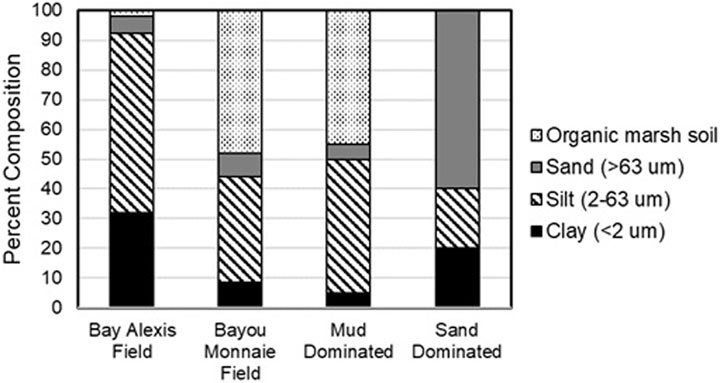
Figure 4. Comparison of modeled data (Mud Dominated and Sand Dominated) and field collected percentage of sediment types representing the top of the terrace.
The cohesive sediment transport model parameters were determined through a review of relevant literature. Specifically, various critical shear stress values for mud and organic marsh soil were extracted from similar numerical modeling studies. For mud in coastal Louisiana, the typical critical shear stress ranges from 0.03 to 2.0 Pa, as reported in studies conducted in Atchafalaya Bay (Edmonds and Slingerland, 2010; Liu et al., 2020), Wax Lake Delta (Nardin and Edmonds, 2014), and the northern Gulf of Mexico (Zang et al., 2019). The critical shear stress for organic mud soil in Jamaica Bay, NY, varies from 0.5 to 1.5 Pa for low to high marsh conditions (Hu et al., 2018). In this study, calibrated values of 0.15, 0.01, and 1.5 Pa for silt, clay, and organic soil marsh, respectively, were used. This was based on research conducted in the Lower Mississippi Deltaic Plain (Baustian et al., 2018). Additional parameters related to cohesive sediment transport modeling were based on Baustian et al. (2018) and are detailed in Table 1. For sand transport, including suspended sediment and bedload transport, the Van Rijn formulation (Van Rijn, 2007a; Van Rijn, 2007b) in Delft3D was used with the median diameter of sand D50 = 100 µm.
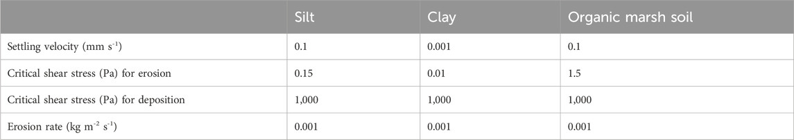
Table 1. Sediment transport parameters used for the model setup.
2.3.3.2 Vegetation
Bay Alexis was diverse fresh marsh with multiple vegetation species observed on the terraces including, Spartina cynosuroides, Sagittaria platyphylla, and Shoenoplectus americanus. The dominant vegetation type at Bayou Monnaie was saline marsh (i.e., Spartina alterniflora). Mangroves (Avicennia germinans) were not present at either of the terrace sites but do occur in Louisiana saline marshes and have potential for greater wave attenuation (Hijuelos et al., 2019). It has been observed that mangrove forests in coastal Louisiana have consistently migrated northward due to increases in mean air temperature (Osland et al., 2017; Osland et al., 2022). To test the potential affect of Spartina alterniflora being replaced by Avicennia germinans in the future, measurements of mangroves were taken at a third location near Grand Isle, Louisiana following the same procedure as the emergent vegetation. Table 2 shows the vegetation parameters such as vegetation height, diameter, and density. Based on field measurements, the terrace was categorized into three zones (i.e., bottom edge of terrace, outer [side slope] terrace, and inner [top] terrace).
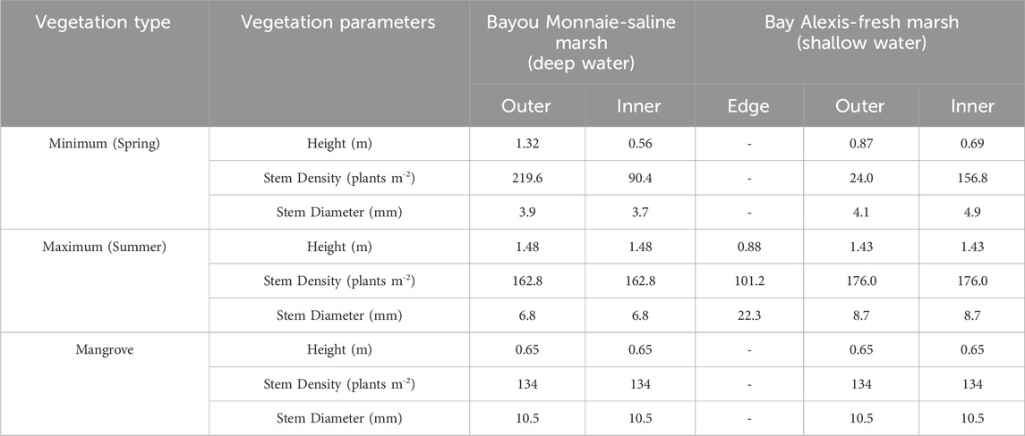
Table 2. Vegetation parameters used in the scenario runs.
2.3.4 Model boundary conditions
The model domain had three open boundaries and one land boundary (the levee side on the right; Figure 2A). It was assumed that waves and currents propagated from left (open boundary) to right in the model grid. Lateral open boundaries were defined using the radiation boundary condition, ensuring that waves generated in the model domain passed through the lateral boundaries with minimal reflection.
Two boundary conditions were established for the model tests: calm and storm conditions (Figure 5). In the calm condition, water elevation (Figure 5B) and wave (Figure 5C) data measured at Bayou Monnaie were assigned to the open boundary. Wind data (Figure 5A) based on the Grand Isle NOAA station (8761724) was utilized to enhance bottom shear stresses near the terraces due to locally generated short-period waves. To simplify the model tests, wind and wave direction were fixed perpendicular to the terraces (i.e., from left to right). Total suspended sediment (TSS) concentrations at the open boundary were estimated using the field turbidity measurements by applying the relationship (Equation 1.; Meselhe et al., 2015).
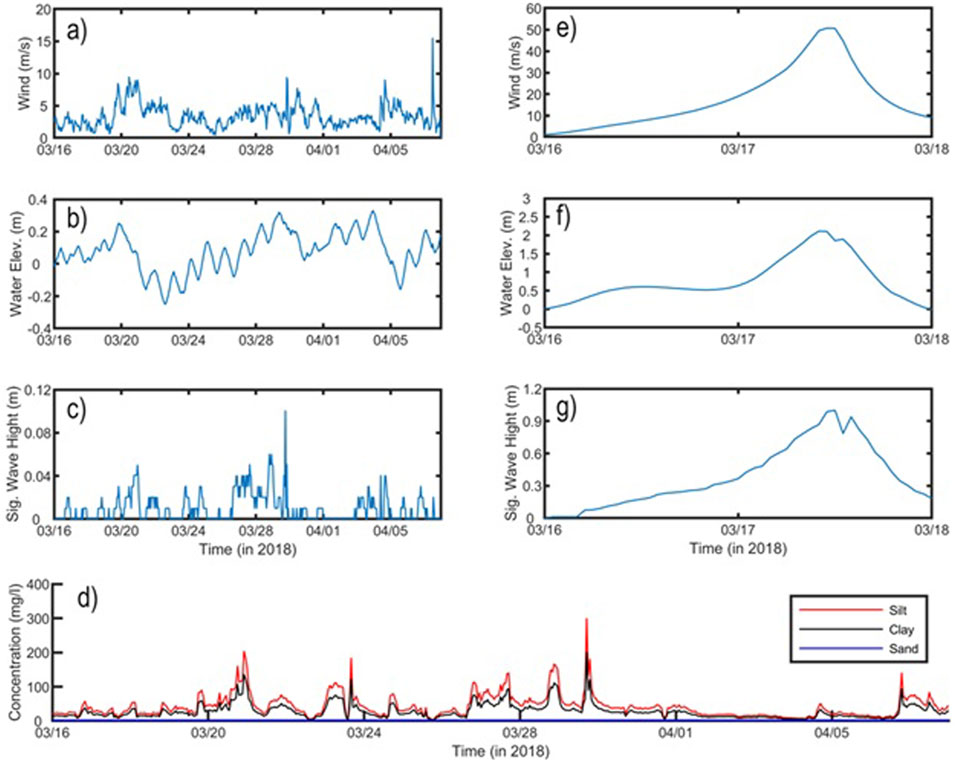
Figure 5. Model boundary conditions for calm (A–D) and storm (E–G) conditions (note different scales). Concentrations in (D) refer to suspended sediment concentrations for silt, clay, and sand. Suspended sediment concentrations during storm conditions were specified by peak values measured during the field measurement period (D).
The estimated TSS was divided into 40% silt and 60% clay. Sand was not considered, given that it makes up a relatively small portion (<10%) of TSS. Additionally, organic matter was excluded from the inflow conditions through the open boundary, under the assumption that the majority of organic matter originates from vegetation on the terraces.
The boundary conditions for the storm were based on results of a Hurricane Katrina (2005) simulation developed by Baustian et al. (2020). From the simulated model results, wind (Figure 5E), water elevation (Figure 5F), and wave (Figure 5G) time series data were extracted at Bay Alexis. Sediment concentrations for sand, silt, and clay at the open boundary were defined as 0, 200, 300 mg/L, respectively, based on peak concentrations measured during the calm condition (see Figure 5D). The simulation represented a 48 hour storm.
2.4 SAV potential habitat
Potential habitat for SAV was estimated using simulated model results because SAV is recognized as providing valuable ecosystem services such as juvenile fish habitat and carbon sequestration (Hillmann et al., 2020). SAV habitat suitability is influenced by various factors, including geomorphological and bathymetric characteristics (e.g., protected shoals or bays), bottom sediment types (e.g., grain size and organic content), physical properties (e.g., waves, currents), and water quality (e.g., water clarity, salinity, temperature; Eisemann et al., 2021). These factors play a crucial role in both SAV recruitment and the survival of existing meadows.
SAV, especially dense meadows, can influence water flow and waves (Zhang and Nepf, 2019) but was left out of the modeling as within coastal Louisiana, it has high spatial and temporal variability (DeMarco et al., 2018). In this study, the SAV suitability (potential SAV habitat) was based on (1) exposure (water depth) and (2) physical disturbance (shear stress), which were considered important physical conditions that could preclude SAV occurrence. Suitability for SAV was determined by water depth: water depths less than 10 cm were defined by the model as land, excluding SAV, and a depth of 1 m was assumed to be to the maximum depth limit, due to light limitation (Hillmann et al., 2020). Physical disturbance was determined by shear stress at the sediment surface. Previous studies have found that there is a maximum of 0.5 Pa of shear stress over which certain SAV species were not observed (Van Zuidam and Peeters, 2015). Already rooted plants may tolerate a higher shear stress during storms depending on the species and sediment structure (Schutten et al., 2005; Howes et al., 2010).
For assessment of SAV potential habitat in this study, it was assumed that critical shear stress for SAV was 0.5 Pa. This shear stress is consistent with other current SAV models (DeMarco et al., 2018) and data (Hillmann, 2018). Salinity is also a critical determinant of SAV occurrence in coastal Louisiana (Bornette and Sara, 2011; Kemp et al., 2004; Koch et al., 2006; Shields and Moore, 2016), however because it varies at a coastal scale rather than a project site scale, it was assumed to be ideal for SAV in all scenarios. Furthermore, it was recognized that calculated potential SAV habitat was or comparative purposes and that many non modeled processes (such as recruitment) may result in the potential habitat not being occupied.
2.5 Comparative analyses
The numerical model was utilized to evaluate potential benefits of marsh terrace restoration. First, five terrace designs were compared to select the optimal design for use in subsequent comparisons (Figure 6). For these subsequent comparisons, a single variable (vegetation, sediment, water depth) was varied, holding the other variables constant under simulated storm conditions (Figure 7). Lastly, the model results were used to assess the potential impacts on SAV, assuming that all potential SAV habitat was fully occupied. The model input data for this analysis were based on data calibrated and validated in a previous study in coastal Louisiana (Baustian et al., 2018), as well as additional field measurements.
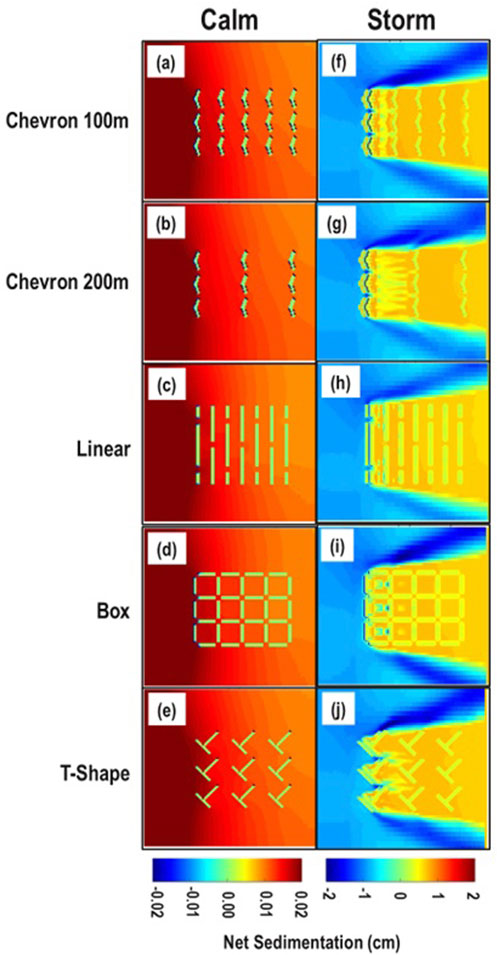
Figure 6. Comparison of five terrace designs under both calm and storm conditions, while keeping other conditions constant [i.e., deep water depth, sand-dominant type, and minimum (spring) vegetation]. Note the orders of magnitude change in the scale bar for the storm condition. Chevron 100 m refers to a chevron type terrace with 100 m spacing. Chevron 200 m refers to a chevron type terrace with 200 m spacing. Linear represents a linear type terrace. Box referes to a box type terrace. T-shape indicates a T-shape type terrace.
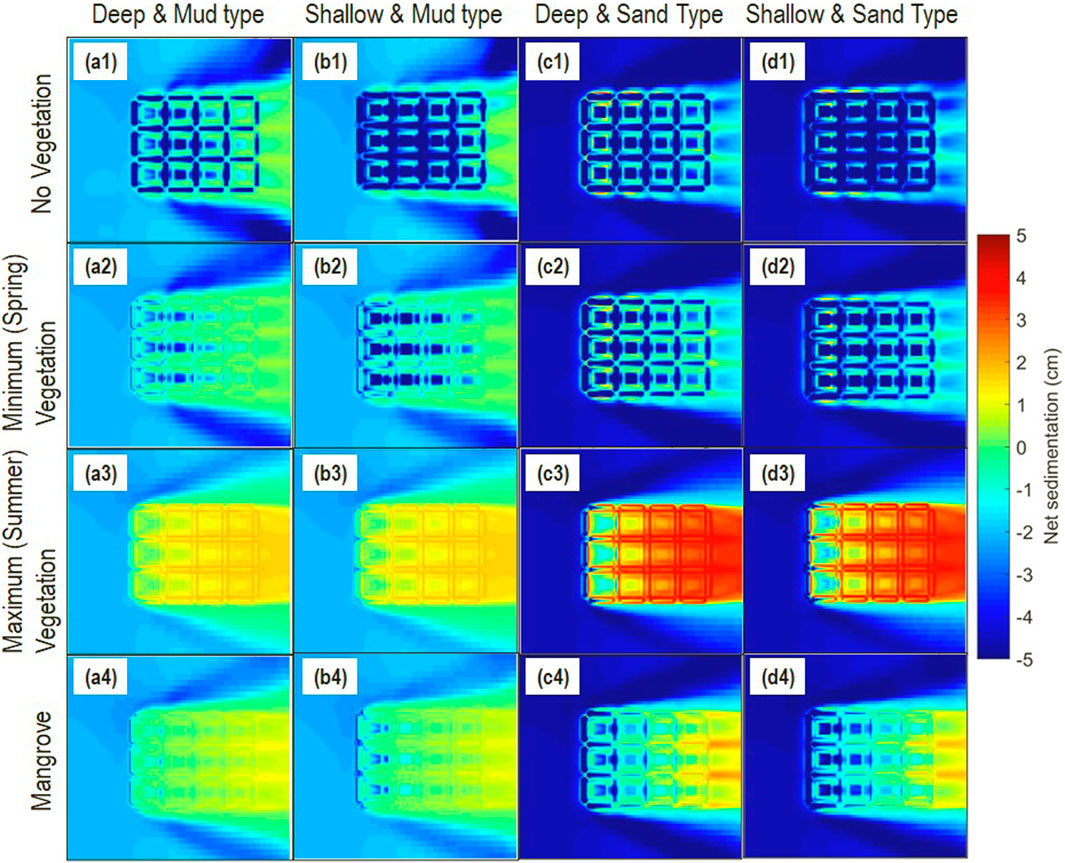
Figure 7. Results, using the box type terrace under storm conditions, for effects of variation in vegetation, sediment type and water depths. “Deep” and “Shallow” refer to −1.0 m and −0.5 m water depths, respectively. “Mud” and “Sand” refer to mud-dominated and sand-dominated sediment at the terrace, respectively.
This approach does not account for the variability and uncertainty inherent in potential outcomes, as the model output provides a single iteration for each scenario, resulting in a deterministic output. While not replicated as multiple iterations, each reported data point for elevation change, for example, is a mean value in space of the 5 m model grid cells that represent the emergent component of each terrace. Therefore each reported number does represent a central tendency from multiple (tens of thousands) individual grid cells. The primary aim of this study was to explore these deterministic outcomes under specific scenarios.
3 Results
3.1 Terrace design comparisons
The evaluation of five terrace designs (Figure 3) was conducted considering deep water (−1.0 m), the sand-dominant type, and minimum (spring) vegetation, under both calm and storm conditions (Figure 6). The terrace performance was evaluated in terms of net sedimentation rates (cumulative sedimentation and erosion).
Under calm conditions, there was negligible difference in sedimentation rate amongst terrace designs and sedimentation was low in all cases with a 0.2 mm maximum sedimentation during the simulation periods (23 days). No erosion occurred around the terraces regardless of terrace designs, and minimal sediment deposition was observed (Figures 6A–E). Under calm conditions, the chevrons with 100 m spacing (Figure 6A) had no sediment erosion at the front of the terraces facing waves and currents. However, some sediment was deposited between the terraces. The sediment deposition decreased toward the center of the terrace field. This result indicated that the deposited sediment was transported from outside the terrace field instead of being eroded and redeposited within the terrace field. Similar sedimentation and erosion patterns near the terrace fields were found for all terrace designs (Figures 6B–E).
Conversely, in storm conditions (Figures 6F–J), large amounts of erosion were observed at the top of the terraces, with sediment movement and deposition throughout all terrace designs. The storm condition also showed increased erosion surrounding the terraces (Table 3). In particular, the front emergent terraces exposed directly to storm conditions were eroded up to 10 cm in the 100 m spaced chevron case (Figure 6F), and the lateral sides of the terrace field were also eroded in the direction of water flow due to strong wave and current interactions. Sediment was deposited within borrow areas around the terraces and the maximum sedimentation was 1.2 cm. Most of the sediment deposited within the terrace field was composed of sand originating from the terraces themselves, rather than from outside the terrace field. Despite strong waves and currents resulting in sediment erosion, movement, and deposition, the majority of the terraces were intact after the simulated major storm.
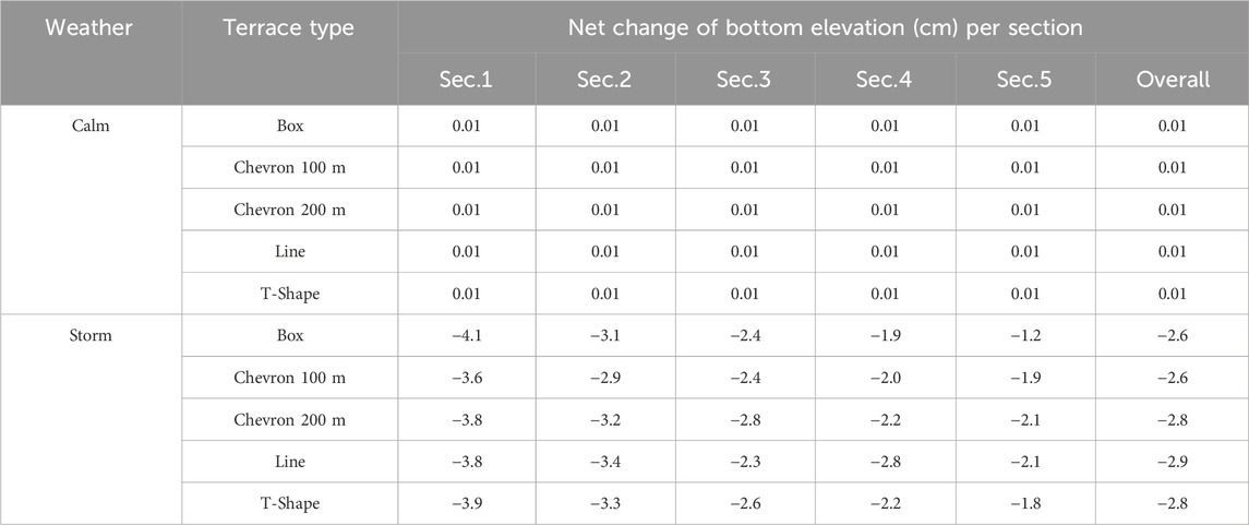
Table 3. Net changes of bottom elevation for five different terrace types with sand-dominant, minimum (spring) vegetation, and deep water under calm and storm conditions. See Figure 2B for explanation of reporting sections (Sec.1 through Sec.5).
For the remaining comparisons, a single terrace design was chosen for further evaluation. The Chevron 200 m, line, and T-shape designs (Figures 6G, H, J), which had exhibited the highest rates of erosion (Table 3), were not tested further. Both the Chevron 100 m (Figure 6F) and box terrace designs (Figure 6I) demonstrated the least erosion in the simulations. However, the box design was selected for further analysis due to its higher resilience to multiple wave and storm directions. For further comparisons the box terrace design was then simulated with storm conditions since calm conditions had minimal effects on any terrace designs over 23 days.
3.2 Emergent vegetation comparison
A series of comparisons were conducted using multiple design runs of the numerical model so as to understand the effect of vegetation on efficacy of the box terrace design. Four vegetation conditions on top of the terraces were modeled: 1) no vegetation, 2) minimum (spring) vegetation biomass, 3) maximum (summer) vegetation biomass, and 4) mangrove (Table 2). Under storm conditions, each of these four vegetation conditions was compared in combination with deep (−1.0 m) or shallow (−0.5 m) water depth and mud or sand sediment types.
In the deep water and mud sediment case (Figure 7A), there was a large effect of vegetation type on sediment erosion of the terraces and subsequent sedimentation. In the absence of vegetation (Figure 7a1), the front terraces exposed directly to storm conditions experienced greatest erosion, exceeding 20 cm compared to the initial condition, and erosion was observed across the entire terrace field. Erosion from between the terraces was minimal in comparison to the terraces themselves. There was erosion at the front of terraces with minimum vegetation (Figure 7a2) and mangrove (Figure 7a4), while terraces with maximum vegetation (Figure 7a3) exhibited no visible erosion. The sediment that eroded from the front terraces appeared to be deposited at the back of the terrace field.
Sediment deposition and erosion patterns inside the terrace field varied with the vegetation type on top of the terraces. Maximum vegetation biomass showed much less terrace sediment erosion and greater sediment deposition onto the terraces (Figure 7a3) compared to minimum vegetation biomass (Figure 7a2) or mangroves (Figure 7a4). The maximum vegetation biomass (height: 1.43 m and density (= stem density x stem diameter): 1.5/m) additionally showed less erosion on the tops and slopes of the terraces compared to mangrove with the height (0.65 m) and density of (1.4/m). Considering similar vegetation biomass, vegetation height had a greater effect than vegetation density in reducing the erosion of terraces.
The effects of terrace vegetation on sediment erosion and deposition were similar for shallow water depth and sand-dominated type terraces (Figure 7D) compared to deep water and mud-dominant type terraces (Figure 7A). However, there was greater sediment erosion within and surrounding the terrace field, with higher erosion observed on the front terraces exposed directly to storm conditions. In the absence of vegetation (Figure 7d1), a significant portion of both the emergent terraces and the submerged areas within the terrace field eroded. A similar pattern was evident in the minimum vegetation scenario (Figure 7d2). Under the maximum vegetation scenario (Figure 7d3), erosion was confined to the front terraces exposed directly to storm conditions, while sediment deposition occurred in the rear terrace field.
The overall net change of bottom elevation in the terrace site was calculated (Table 4). The modeled results demonstrated that the presence of terrace vegetation enhanced the terrace stability and trapped sediments inside the terrace field during the storm period, regardless of sediment type and water depth of the terrace field.
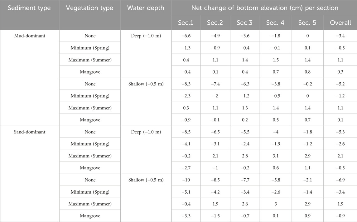
Table 4. Net changes in bottom elevation in the box terraces due to variations of vegetation, sediment, and water depth under storm conditions. See Figure 2B for explanation of sections (Sec.1 through Sec.5).
3.3 Sediment type effect
Terraces with two different sediment types, mud-dominated and sand-dominated, were tested to investigate whether sediment type influenced terrace morphological change after a simulated storm. First, the two sediment types were compared under storm conditions for deep water, with four different vegetation conditions (Figures 7A, C). Both the terraces constructed of mud (Figure 7a1) and of sand (Figure 7c1) had significant erosion with no vegetation, more in the case of sand-dominated (overall net change of bottom elevation was −5.3 cm in Table 4) than for mud-dominated (−3.4 cm in Table 4). For minimum vegetation, mud-dominated terraces (Figure 7a2) showed less erosion on their tops and higher sediment deposition in submerged areas between terraces within the terrace field compared to the sand-dominant terraces (Figure 7c2). With maximum vegetation and mangrove, the mud-dominant terraces exhibited minimal terrace erosion (Figure 7a2; Figure 7a4), even for the front terraces that had the greatest exposure to water current and waves. In contrast, the sand-dominant terraces showed erosion at the front but more deposition within the terraces (Figure 7c3; Figure 7c4). However, the high sedimentation observed in terraces constructed of sand (Figure 7c3; Figure 7c4) was attributed to the increased erosion on both the front terraces exposed directly to storm conditions and the sediment at the bottom of the outer areas of the terrace field. The comparison in shallow water depth (Figures 7B, D) yielded similar results to the deep water depth.
3.4 Water depth effect
The two different water depths between emergent terraces (deep and shallow; Figure 2C) were tested to investigate the influence of interior water depth on terrace morphological changes. These were established as deep, with a bottom elevation inside terraces of −1 m and shallow, with a bottom elevation inside terraces of −0.5 m. The comparison also included both sediment types as well as four different vegetation types under storm conditions.
In the case of no vegetation, modeled deep and shallow terrace fields experienced significant erosion, particularly affecting the exposed side of the terrace field. The shallow terrace field had more sediment erosion than the deep terrace field (−3.4 cm vs.-−5.2 cm for mud sediment type; −5.3 cm vs. −6.9 cm for sand sediment type in Table 4). A similar pattern was observed for minimum vegetation and mangrove conditions (Figures 7a2–d2; Figures 7a4–d4). However, under the maximum vegetation condition, both water depths exhibited a similar pattern with visible erosion limited to the exposed edge of the terrace field (for mud: Figure 7a3; Figure 7b3 and for sand; Figure 7c3; Figure 7d3). The overall net changes, including emergent terraces and submerged areas, were also very similar (1.1 cm vs. 1.1 cm for mud-dominated sediment type; 2.1 cm vs. 1.9 cm for sand-dominated sediment type in Table 4).
3.5 Potential SAV habitat
Based on modeled water depth and bottom shear stress, potential SAV habitat was evaluated for the different sediment types and water depths between terraces under each of the four emergent vegetation types (Table 5 and Figure 8). In the storm conditions, the potential SAV habitat was evaluated using bottom elevation updated at the end of storm simulation because strong current and high wave energy eroded the terraces and redistributed sediments originating from both the front terraces exposed directly to storm conditions and the sediment at the bottom of the outer areas of the terrace field. The maximum shear stress simulated during the storm period was also used to determine potential SAV habitat.
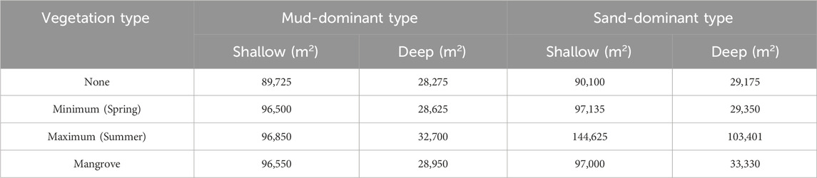
Table 5. Potential SAV habitat area after 48 hours of simulated storm conditions within box terraces with varying vegetation density, sediment type, and water depth between the terraces.
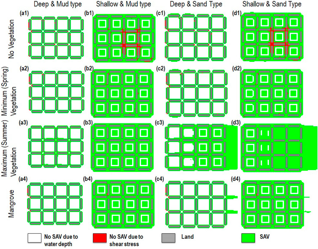
Figure 8. Potential SAV habitat distribution using the box type terrace for effects of vegetation, sediment type and water depth of the terrace site under storm conditions. “Deep” and “Shallow” refer to deep and shallow water depths at the terrace sites, respectively. “Mud” and “Sand” denote mud-dominated and sand-dominated sediment types at the terrace, respectively.
The spatial distribution of potential SAV habitat showed minor variation with different sediment and vegetation conditions, but the largest variation was related to water depth between terraces, with higher potential SAV habitat at the shallow areas (green areas in Figures 8B, D) compared to the deep areas (green areas in Figures 8A, C). During the storm period, strong currents and high wave energy propagated into the terrace field but most of wave energy was dissipated and current speeds were reduced due to the shallow depth inside the terrace field and vegetation on top of the terraces.
For mud-dominant terraces, potential SAV habitats were influenced by the initial water depth in the terrace field because the terraces exhibited minimal sediment erosion. The sand-dominant terraces also displayed a pattern similar to the mud-dominant terraces across most vegetation types, including no vegetation, minimum vegetation, and mangrove, except for maximum vegetation. However, with maximum vegetation, the sand-dominated terraces demonstrated the ability to trap and retain a substantial amount of sediment eroded from both the front terraces exposed directly to storm surges and the sediment at the bottom of the outer areas of the terrace field. In general, the spatial distribution of potential SAV habitat showed a pattern similar to the net sediment deposition (Figures 7, 8) because the SAV suitability inside the terrace field was primarily determined by suitable water depth.
4 Discussion
The effectiveness of marsh terraces constructed as nature-based solutions were evaluated using numerical model experiments based on field sampling of vegetation and physical parameters. Common terrace designs were tested. The box and Chevron 100 m terraces of combined wave, current, and surge had the greatest sediment retention, particularly when positioned perpendicular to prevailing winds. The preferred design, the box terrace, demonstrated resilience for all wind and wave directions. Vegetation presence on top of terraces, especially with maximum vegetation biomass, enhanced terrace stability against erosion. Deeper water depths between terraces increased sediment retention, with terraces composed of mud exhibiting greater stability. The model revealed that vegetation had the most substantial impact on sediment retention, while water depth was the primary determinant of potential habitat for SAV.
Future research might consider stochastic analysis to account for the variability and uncertainty inherent in the model outputs. For this study, the addition of field data, such as sedimentation rates, through long-term monitoring at terrace sites would have been beneficial to reduce uncertainty in model output further. Understanding the meaningful ranges for each model input parameter would further increase the reliability of the stochastic outputs. It was not possible to validate current model outputs with field data, although they were calibrated with field measurements.
4.1 Terrace design comparisons
In this study, five terrace designs (i.e., chevrons with 100 m spacing (Chevron 100 m), chevrons with 200 m spacing (Chevron 200 m), linear, box, and T-shape) were compared under calm and storm conditions with deep water between the terraces sand-dominant sediment, and minimum (spring) vegetation. In the calm condition scenario, no significant differences among terrace designs were observed in terms of stability of the emergent terraces and sediment deposition in submerged areas between the emergent terraces (Figure 6). However, a significant difference was observed in the storm conditions. The Chevron 100 m and box terraces exhibited higher efficacy than the Chevron 200 m, linear, or T-shape. In particular, a comparison between Chevron 100 m and 200 m highlighted the effect of distance between terraces. A shorter distance between the emergent terraces resulted in less erosion from the emergent terraces and an increase in sedimentation within the terrace field.
Based on efficacy in terms of least erosion of emergent terraces and maximum retention of sediment within the terrace field, the box terrace design was optimal because it would function equally well for storms from any direction. Hurricanes, including Katrina, Rita, Gustav, and Ike have been observed to erode terraces (Osorio et al., 2020). Therefore, the box design may be preferred as it provides equal efficacy regardless of the hurricane paths and wind directions and hurricanes have highly variable paths even if seasonal winds and cold fronts have a dominant and predictable direction.
However, in some locations, this advantage might not justify the potentially higher construction cost of the box design. In a recent study comparing terrace designs in coastal Louisiana (Osorio et al., 2024), the chevron type with 120 m terrace spacing was identified as the optimal design, considering construction costs and wave reduction, especially in areas where bi-directional wind waves were dominant. Nevertheless, that study also concluded that the box terrace design could be considered optimal in situations where wind directions are not perpendicular to the terrace site.
4.2 Effects of vegetation, sediment type and bottom elevation on terrace performance
The terrace, conceived as a nature-based solution, was designed to mitigate wetland loss by reducing incoming wave energy and enhancing or restoring marsh ecosystems through increased sediment capture. Construction of marsh terraces is cheaper than constructing continuous marsh as they require much less sediment and often can be built using local sediment from within the restoration site. This study examined three parameters that could influence terrace performance using the box terrace design, vegetation, sediment type, and water depth between the emergent terraces.
Vegetation on top of the terraces was found to have the greatest influence on stability of the emergent terraces and sediment deposition within the terrace field, whereas the effect of water depth between terraces was not significant. Maximum vegetation, characterized by greater height and density, demonstrated considerably less erosion on the emergent terraces and more deposition in the terrace field. Vegetation height had a more substantial impact than vegetation density in reducing terrace erosion under the storm conditions with elevated water depth. This result agrees with a study conducted by Nepf (2012), which found that vegetation height had a more pronounced effect on flow resistance when vegetation density exceeded a certain threshold (i.e., roughness density ≥0.1).
According to Xu et al. (2022), the sedimentation in deltaic marshes showed a nonlinear relationship with vegetation density, with higher sedimentation rates at intermediate vegetation density rather than high density. This is because high vegetation density limited the sediment supply to the inside of marshes by reducing the current velocity. However, considering the relatively narrow width of terraces (approximately 15 m for the top and both sides) and the terraces’ intended benefit to reduce shoreline erosion and increase sediment deposition between terraces, a higher density of vegetation may prove more effective in maintaining terrace stability and promoting sediment capture on top of terraces, as well as in the spaces between them (Osorio et al., 2020).
The sediment composition of terraces was found to be closely linked to terrace stability, with mud-dominated terraces having high soil shear strength and therefore eroding less than sand terraces. This suggests that muddy materials associated with high organic matter from vegetation might offer better stability for terraces, aligning with findings reported in Hu et al. (2018). The presence of less cohesive soils makes it challenging to construct marsh terraces compared to mudflats, which consist of organics, silt, and clay (Osorio et al., 2020). However, a low mineral sediment rate in soil weakens soil consolidation and reduces friction between roots and surrounding soils, leading to an increased risk of marsh failure (Howes et al., 2010). Model results indicated that the presence of vegetation on sand-dominant terraces enhanced terrace stability by reducing current speeds and wave energy during storm periods. The presence of vegetation also increases soil strength because vegetation roots bind the sediment (Howes et al., 2010).
The benefits of reduced erosion and increased sedimentation provided by vegetation during storm events indicates the benefit of planting marsh terraces, or encouraging natural recruitment, in the construction process, especially in terraces constructed of sand. The advantages of vegetation on terraces become apparent when reflecting on historical events at the research site. The initial construction of the Bay Alexis terraces, which were under construction when almost entirely eroded by Hurricane Katrina in 2005, suggests that lack of vegetation coverage at the time might have contributed to high rate of erosion. However, based on model results, a similar storm today would not be expected to result in the same level of erosion, indicating the potential viability of terraces as a method for habitat creation and storm protection (surge, wave, and current reduction).
Additionally, the seasonal change of marsh vegetation is an important consideration for planting on terraces. Vegetation biomass, including height and density, change throughout the year due to growth and senescence, resulting in higher vulnerability to erosion at some times of the year. For example, when hurricanes occur in late summer and fall, marsh vegetation will be at its maximum. In contrast, during the cold fronts of winter, marsh vegetation will be at its minimum. However, mangroves are expected to maintain similar resilience even during winter storms, although they exhibit greater similarity to spring (minimum) marsh vegetation. Therefore, diversity of vegetation may help terraces maintain resistance to waves based on seasonal wind patterns.
4.3 Potential SAV habitat
The potential SAV habitat in the terrace field was assessed considering simulated water depth and bottom shear stress. Based on the model results, the potential SAV habitat in the terrace field was predominantly influenced by water depth between terraces. The occurrence of high shear stress (>0.5 Pa) within the terrace field was limited to the unvegetated terrace conditions, even though the simulated storm. In cases where vegetation was present on top of the terraces, no loss of potential SAV habitat due to excessive shear stress was observed. This observation can be attributed to the effective attenuation of waves within the terrace site, as noted by Osorio et al. (2024), reducing bottom shear stress within the terrace field.
Remote sensing analysis (Osorio et al., 2020) revealed both high erosion and high sedimentation on terraced sites after storm events. Sediments in the terrace were assumed to originate from both terrace erosion and external storm-driven sediment supply (Osorio et al., 2020). In the current study, model results (Figures 7, 8) also showed high erosion and sedimentation after storm events, especially in sand-dominant terraces with maximum (summer) vegetation, where increased potential SAV habitats in both deep and shallow water depths resulted from substantial sediment deposition during the storm event. These findings clearly illustrate the crucial role of vegetation type in trapping and retaining sediments within the terraces, regardless of the sediment type present in the terraces.
Sediment deposition and erosion can impact existing SAV habitats because significant changes in bed elevation during storm events can affect SAV growth and distribution (Eisemann et al., 2021). High sediment erosion during storms may damage SAV beds by removing aboveground leaf material and uprooting plants, while high sedimentation can bury and kill SAV, as observed in Ship Island, Mississippi, with a sedimentation rate over 5 cm/year (Eisemann et al., 2019).
Based on the model results, two key considerations emerge to enhance potential SAV habitats within terrace fields. First, the water depth inside the terrace field should be shallow for optimal SAV growth. The establishment of SAV habitats within the terrace field may increase wave attenuation and sedimentation, thereby enhancing terrace stability. Second, potential SAV habitat will be attained when emergent vegetation is growing on the terraces post-construction. Prioritizing planting and appropriate vegetation types on top of built marsh terraces can maximize terrace stability and increase sedimentation within the terrace field. Planting created terraces will also maximize the potential area of SAV habitat within the terrace field.
5 Conclusion
Marsh terraces, implemented as a restoration and protection strategy along the Louisiana coast, were assessed for their efficacy as a nature-based solution using a hypothetical idealized model based on local field measurements. Multiple parameters influencing terrace stability and sediment capture, including terrace design, vegetation, sediment type, and water depth, were evaluated.
It was found that the presence of vegetation on the terrace minimized erosion and enhancing sediment capture, even under storm conditions. Increasing vegetation height and density improved terrace stability and enhanced sediment-capture. In addition to sediment capture, the terraces provided large areas of potential SAV habitats, given that SAV grow primarily in relatively shallow and low-energy environments.
While the model was developed using field data from specific Louisiana marsh sites, it is generalizable as a valuable tool for planning terrace restoration projects in any similar coastal habitats. Looking forward, these findings contribute not only to our understanding of marsh terrace dynamics but also offer insights for future terrace restoration project planning, emphasizing the critical role of vegetation in promoting both stability and ecological benefits in coastal environments.
Data availability statement
The raw data supporting the conclusions of this article will be made available by the authors, without undue reservation.
Author contributions
HJ: Conceptualization, Data curation, Formal Analysis, Investigation, Methodology, Validation, Visualization, Writing–original draft. LM: Conceptualization, Data curation, Investigation, Methodology, Writing–original draft. TC: Conceptualization, Methodology, Project administration, Supervision, Writing–review and editing. DD: Data curation, Formal Analysis, Methodology, Writing–review and editing. KD: Writing–review and editing. MW: Formal Analysis, Writing–review and editing. MB: Writing–review and editing. JD: Methodology, Writing–review and editing.
Funding
The author(s) declare that financial support was received for the research, authorship, and/or publication of this article. This project was supported, in part, by the Coastal Protection and Restoration Authority and the Baton Rouge Area Foundation, both of Baton Rouge, Louisiana, United States, as a part of The Water Institute’s Science and Engineering Plan.
Acknowledgments
William Cenac and John Hetherwick, Ducks Unlimited, Inc., provided background on engineering and construction of the Bayou Monnaie site, in addition to boat transportation and insights in the field. The collection of field data was supported by Dallon Weathers, Cyndhia Ramatchandirane, and Andrea Jerabek with guidance from Melissa Baustian. Ehab Meselhe provided advice on initial modeling approaches, Kelin Hu assisted with aspects of model set up and some model runs. Mead Allison provided guidance and input to project conception, design, and collection of field data. Graphic designs were done by Erin Kiskaddon. The authors thank Edwin Elias at Deltares for help with model selection and setup.
Conflict of interest
Author MB was employed by Ducks Unlimited, Inc.
The remaining authors declare that the research was conducted in the absence of any commercial or financial relationships that could be construed as a potential conflict of interest.
Publisher’s note
All claims expressed in this article are solely those of the authors and do not necessarily represent those of their affiliated organizations, or those of the publisher, the editors and the reviewers. Any product that may be evaluated in this article, or claim that may be made by its manufacturer, is not guaranteed or endorsed by the publisher.
Supplementary material
The Supplementary Material for this article can be found online at: https://www.frontiersin.org/articles/10.3389/fenvs.2024.1432732/full#supplementary-material
References
Baptist, M. J., Babovic, V., Uthurburu, R., Keijzer, M., Uittenbogaard, R. E., Mynett, A., et al. (2007). On inducing equations for vegetation resistance. J. Hydraulic Res. 45 (4), 435–450. doi:10.1080/00221686.2007.9521778
Baustian, M. M., Jung, H., Bienn, H. C., Barra, M., Hemmerling, S. A., Wang, Y., et al. (2020). Engaging coastal community members about natural and nature-based solutions to assess their ecosystem function. Ecol. Eng. 143, 100015. doi:10.1016/j.ecoena.2019.100015
Baustian, M. M., Meselhe, E., Jung, H., Sadid, K., Duke-Sylvester, S. M., Visser, J. M., et al. (2018). Development of an integrated biophysical model to represent morphological and ecological processes in a changing deltaic and coastal ecosystem. Environ. Model. and Softw. 109 (November), 402–419. doi:10.1016/j.envsoft.2018.05.019
Bornette, G., and Sara, P. (2011). Response of aquatic plants to abiotic factors: a review. Aquat. Sci. 73 (1), 1–14. doi:10.1007/s00027-010-0162-7
Brasher, M. G. (2016) “Review of the benefits of marsh terraces in the northern Gulf of Mexico,” in Literature review. Lafayette, LA: Ducks Unlimited, Inc., Gulf Coast Joint Venture.
Caldwell, A. B. (2003). Do terraces and coconut mats affect seeds and submerged aquatic vegetation at sabine national wildlife refuge? Thesis: Louisiana Tech University. Available at: http://etd.lsu.edu/docs/available/etd-0625103-110131/.
Cannaday, C. D. (2006) Effects of terraces on submerged aquatic vegetation in shallow marsh ponds in coastal southwest Louisiana. Ruston, LA: Thesis, Louisiana Tech University. Available at: http://etd.lsu.edu/docs/available/etd-06032006-113117/.
Castellanos, D., and Aucoin, S. (2004). “2004 operations, maintenance, and monitoring report for little vermilion bay sediment trapping.” TV-12. Lafayette, Louisiana: Louisiana department of natural resources. Coast. Restor. Div.
Couvillion, B. R., Barras, J. A., Steyer, G. D., Sleavin, W., Fischer, M., Beck, H., et al. (2011) “Land area change in coastal Louisiana from 1932 to 2010,” in U.S. Geological survey scientidic investigations map 3164. Reston, VA: U.S. Geological Survey.
CPRA (2017). Louisiana’s comprehensive master plan for a sustainable coast: committed to our coast. Coast. Prot. Restor. Auth. Available at: http://www.icevirtuallibrary.com/doi/abs/10.1680/cmsb.41301.0034.
DeMarco, K., Brady, C., Brown, S., and Peyre, M.La (2018). Submerged aquatic vegetation mapping in coastal Louisiana through development of a spatial likelihood occurrence (SLOO) model. Aquat. Bot. 151 (December), 87–97. doi:10.1016/j.aquabot.2018.08.007
Edmonds, D. A., and Slingerland, R. L. (2010). Significant effect of sediment cohesion on delta morphology. Nat. Geosci. 3 (2), 105–109. doi:10.1038/ngeo730
Eisemann, E., Altman, S., Acevedo-Mackey, D., and Reif, M. (2019). Relating seagrass habitat to geomorphology and substrate characteristics around Ship Island, MS. U.S.: Engineer Research and Development Center. doi:10.21079/11681/33023
Eisemann, E., Thomas, C., Balazik, M., Acevedo-Mackey, D., and Altman, S. (2021). Environmental factors affecting coastal and estuarine submerged aquatic vegetation (SAV). U.S.: Engineer Research and Development Center. doi:10.21079/11681/42185
Elsey-Quirk, T., Graham, S. A., Mendelssohn, I. A., Snedden, G., Day, J. W., Twilley, R. R., et al. (2019). Mississippi river sediment diversions and coastal wetland sustainability: synthesis of responses to freshwater, sediment, and nutrient inputs. Estuar. Coast. Shelf Sci. 221 (May), 170–183. doi:10.1016/j.ecss.2019.03.002
Feher, L. C., and Hester, M. W. (2018). The interactive effects of created salt marsh substrate type, hydrology, and nutrient regime on Spartina alterniflora and Avicennia germinans productivity and soil development. Wetl. Ecol. Manag. 26 (4), 715–728. doi:10.1007/s11273-018-9603-1
Hijuelos, A. C., Dijkstra, J. T., Carruthers, T. J. B., Heynert, K., Reed, D. J., and van Wesenbeeck, B. K. (2019). Linking management planning for coastal wetlands to potential future wave attenuation under a range of relative sea-level rise scenarios. PLOS ONE 14 (5), e0216695. 10/grpfmb. doi:10.1371/journal.pone.0216695
Hillmann, E. R. (2018). Analysis of submerged aquatic vegetation resources across the northern Gulf of Mexico: communities and biomass. Baton Rouge, LA: Louisiana State University. Available at: https://digitalcommons.lsu.edu/gradschool_dissertations/4564.
Hillmann, E. R., Rivera-Monroy, V. H., Nyman, J. A., and La Peyre, M. K. (2020). Estuarine submerged aquatic vegetation habitat provides organic carbon storage across a shifting landscape. Sci. Total Environ. 717 (May), 137217. doi:10.1016/j.scitotenv.2020.137217
Howes, N. C., FitzGerald, D. M., Hughes, Z. J., Georgiou, I. Y., Kulp, M. A., Miner, M. D., et al. (2010). Hurricane-induced failure of low salinity wetlands: supporting information. Proc. Natl. Acad. Sci. 107 (32), 14014–14019. doi:10.1073/pnas.0914582107
Hu, K., Chen, Q., Wang, H., Hartig, E. K., and Orton, P. M. (2018). Numerical modeling of salt marsh morphological change induced by hurricane sandy. Coast. Eng. 132 (February), 63–81. doi:10.1016/j.coastaleng.2017.11.001
Hymel, M., and Breaux, K. 2012. 2012 operations, maintenance, and monitoring report for delta management at fort st. Philip. state project BS-11. New Orleans, LA: Coastal Protection and Restoration Authority of Louisiana.
IPCC (2014). Climate change 2014: synthesis report. contribution of working groups I, II and III to the fifth assessment report of the intergovernmental panel on climate change. Geneva, Switzerland: IPCC.
Kemp, M. W., Batleson, R., Bergstrom, P., Carter, V., Gallegos, C. L., Hunley, W., et al. (2004). Habitat requirements for submerged aquatic vegetation in chesapeake bay: water quality, light regime, and physical-chemical factors. Estuaries 27 (3), 363–377. doi:10.1007/BF02803529
Kim, H. D., Xiao, Yu, and Kaplan, D. (2024). Steady flow over a finite patch of submerged flexible vegetation. Water Resour. Res. 60 (1), e2023WR035222. doi:10.1029/2023wr035222
Koch, E. W., Sanford, L. P., Chen, S.-N., Shafer, D. J., and Smith, J. M. (2006). Waves in seagrass systems: review and technical recommendations. Fort Belvoir, VA: Defense Technical Information Center. doi:10.21236/ADA458760
Liu, H., Xu, K., Ou, Y., Bales, R., Zang, Z., and George Xue, Z. (2020). Sediment transport near Ship shoal for coastal restoration in the Louisiana shelf: a model estimate of the year 2017–2018. Water 12 (8), 2212. doi:10.3390/w12082212
Mendez, F. J., and Losada, I. J. (2004). An empirical model to estimate the propagation of random breaking and nonbreaking waves over vegetation fields. Coast. Eng. 51 (2), 103–118. doi:10.1016/j.coastaleng.2003.11.003
Meselhe, E., Baustian, M. M., and Allison, M. (2015). Basin wide model development for the Louisiana coastal area Mississippi river hydrodynamic and Delta management study (Baton Rouge, LA: The Water Institute of the Gulf). Funded by the Coastal Protection and Restoration Authority under Task Order 27.1.
Mudd, S. M., Alpaos, A. D. ’, and Morris, J. T. (2010). How does vegetation affect sedimentation on tidal marshes? Investigating particle capture and hydrodynamic controls on biologically mediated sedimentation. J. Geophys. Res. Earth Surf. 115 (F3), 2009JF001566. doi:10.1029/2009jf001566
Nardin, W., and Edmonds, D. A. (2014). Optimum vegetation height and density for inorganic sedimentation in deltaic marshes. Nat. Geosci. 7 (10), 722–726. doi:10.1038/ngeo2233
Nepf, H., and Ghisalberti, M. (2008). Flow and transport in channels with submerged vegetation. Acta Geophys. 56 (3), 753–777. doi:10.2478/s11600-008-0017-y
Nepf, H. M. (2012). Hydrodynamics of vegetated channels. J. Hydraulic Res. 50 (3), 262–279. doi:10.1080/00221686.2012.696559
O’Connell, J. L., and Andrew Nyman, J. (2009). Marsh terraces in coastal Louisiana increase marsh edge and densities of waterbirds. Wetlands 30, 125–135. doi:10.1007/s13157-009-0009-y
Osland, M. J., Day, R. H., Hall, C. T., Brumfield, M. D., Dugas, J. L., and Jones, W. R. (2017). Mangrove expansion and contraction at a poleward range limit: climate extremes and land-ocean temperature gradients. Ecology 98 (1), 125–137. doi:10.1002/ecy.1625
Osland, M. J., Randall Hughes, A., Armitage, A. R., Scyphers, S. B., Cebrian, J., Swinea, S. H., et al. (2022). The impacts of mangrove range expansion on wetland ecosystem services in the southeastern United States: current understanding, knowledge gaps, and emerging research needs. Glob. Change Biol. 28 (10), 3163–3187. doi:10.1111/gcb.16111
Osorio, J. O., Linhoss, A., and Dash, P. (2020). Evaluation of marsh terraces for wetland restoration: a remote sensing approach. Water 12 (2), 336. doi:10.3390/w12020336
Osorio, R. J., Linhoss, A., Skarke, A., Brasher, M. G., and McFarland, M. (2024). Assessment of marsh terrace designs for wave attenuation utilizing a wave model. Dyn. Atmos. Oceans 105 (March), 101429. doi:10.1016/j.dynatmoce.2023.101429
Perry, C. L., and Mendelssohn, I. A. (2009). Ecosystem effects of expanding populations of Avicennia germinans in a Louisiana salt marsh. Wetlands 29 (1), 396–406. doi:10.1672/08-100.1
Renne, J. D., Spann-Winfield, T., Owens, D., and Dluzak, C. (2011). Alexis bay marsh terracing change of location. New Orleans, LA: U.S. Department of Homeland Security, Federal Emergency Managemetn Agency, Region VI.
Van Rijn, L. C. (2007a). Unified view of sediment transport by currents and waves. I: initiation of motion, bed roughness, and bed-load transport. J. Hydraulic Eng. 133 (6), 649–667. doi:10.1061/ASCE0733-94292007133:6649
Van Rijn, L. C. (2007b). Unified view of sediment transport by currents and waves. II: suspended transport. J. Hydraulic Eng. 133 (6), 668–689. doi:10.1061/ASCE0733-94292007133:6668
Rozas, L. P., and Minello, T. J. (2001). Marsh terracing as a wetland restoration tool for creating fishery habitat. Wetlands 21 (3), 327–341. doi:10.1672/0277-5212(2001)021[0327:mtaawr]2.0.co;2
Rozas, L. P., and Minello, T. J. (2007). Restoring coastal habitat using marsh terracing: the effect of cell size on nekton use. Wetlands 27 (3), 595–609. doi:10.1672/0277-5212(2007)27[595:rchumt]2.0.co;2
Schutten, J., Dainty, J., and Davy, A. J. (2005). Root anchorage and its significance for submerged plants in shallow lakes. J. Ecol. 93 (3), 556–571. doi:10.1111/j.1365-2745.2005.00980.x
Shields, E. C., and Moore, K. A. (2016). Effects of sediment and salinity on the growth and competitive abilities of three submersed macrophytes. Aquat. Bot. 132 (July), 24–29. doi:10.1016/j.aquabot.2016.03.005
Steyer, G. D. (1993). Sabine terracing project final report. Annu. Monit. Rep. 4351089. Biol. Monit. Sect. La. Dep. Nat. Resour. Coast. Restor. Div.
Thibodeaux, C., and Guidry, M. (2009). 2009 operations, maintenance, and monitoring report for pecan Island terracing. ME-14. Lafayette, LA La. Dep. Nat. Resour. Coast. Restor. Div.
U.S. Army Corps of Engineers (2013). “Morganza to the Gulf.” Post authorization change report engineering index. Washington, DC: U.S. Army Corps of Engineers - Team New Orleans. Available at: http://www.mvn.usace.army.mil/Portals/56/docs/PD/Projects/MTG/117.pdf.
Van Zuidam, B. G., and Peeters, E. T. H. M. (2015). Wave forces limit the establishment of submerged macrophytes in large shallow lakes: waves limit macrophyte establishment. Limnol. Oceanogr. 60 (5), 1536–1549. doi:10.1002/lno.10115
Vargas-Luna, A., Crosato, A., and Uijttewaal, W. S. J. (2015). Effects of vegetation on flow and sediment transport: comparative analyses and validation of predicting models. Earth Surf. Process. Landforms 40 (2), 157–176. doi:10.1002/esp.3633
Xu, Y., Esposito, C. R., Beltrán-Burgos, M., and Nepf, H. M. (2022). Competing effects of vegetation density on sedimentation in deltaic marshes. Nat. Commun. 13 (1), 4641. doi:10.1038/s41467-022-32270-8
Zang, Z., George Xue, Z., Xu, K., Bentley, S. J., Chen, Q., D’Sa, E. J., et al. (2019). A two decadal (1993–2012) numerical assessment of sediment dynamics in the northern Gulf of Mexico. Water 11 (5), 938. doi:10.3390/w11050938
Keywords: terrace, restoration, modeling, vegetation, SAV
Citation: Jung H, Moss L, Carruthers TJB, Di Leonardo DR, DeMarco K, Whalen M, Brasher M and Dijkstra J (2024) Modeling potential benefits of fragmented marsh terrace restoration in Terrebonne bay, Louisiana: sediment processes interacting with vegetation and potential submerged aquatic vegetation habitat. Front. Environ. Sci. 12:1432732. doi: 10.3389/fenvs.2024.1432732
Received: 14 May 2024; Accepted: 27 August 2024;
Published: 27 September 2024.
Edited by:
Nalini Rao, Electric Power Research Institute (EPRI), United StatesReviewed by:
Zezheng Liu, Sun Yat-sen University, ChinaDouglas Spieles, Denison University, United States
Copyright © 2024 Jung, Moss, Carruthers, Di Leonardo, DeMarco, Whalen, Brasher and Dijkstra. This is an open-access article distributed under the terms of the Creative Commons Attribution License (CC BY). The use, distribution or reproduction in other forums is permitted, provided the original author(s) and the copyright owner(s) are credited and that the original publication in this journal is cited, in accordance with accepted academic practice. No use, distribution or reproduction is permitted which does not comply with these terms.
*Correspondence: Hoonshin Jung, aGp1bmdAdGhld2F0ZXJpbnN0aXR1ZS5vcmc=
‡ORCID ID: Michael Brasher, orcid.org/0000-0002-1331-491X