- School of Architecture, Southeast University, Nanjing, China
Introduction: Xuanwu Lake in Nanjing has undergone a rich history, evolving from native Sangbo to a naval training ground, from an imperial garden to farmland, and finally to a vibrant urban landscape. The lake's legacy can be attributed to its unique geographical and hydrological conditions. Exploring historical transformations of the lake and surrounding landscape patterns provides insights for optimizing urban water space in contemporary China.
Methods: Traditional analyses of lake changes based solely on historical records may lack precision due to deviations and artistic interpretations found in ancient maps. However, considering the reciprocal compatibility between local geomorphology, undulating terrains, and water bodies allows for accurate reduction of the lake's morphology by inferring and validating its geographical features. This research combines historical interpretation and geographical analysis to reconstruct the historical shape of Xuanwu Lake, uncover the intrinsic mechanisms driving spatial changes over time, and analyze the morphological changes and connectivity patterns of its hydrological system.
Results: The morphology and hydrological dynamics of Xuanwu Lake are deeply intertwined with the policies prevailing in different eras. In antiquity, Xuanwu Lake, as a natural body of water, sustained the surrounding ecosystem and the livelihoods of local inhabitants. During the imperial period, it was integrated into the royal gardens, with its utilization and configuration modified by political directives, including the establishment of a naval training facility and its conversion into a royal recreational venue. Subsequently, in response to economic imperatives, Xuanwu Lake was transformed into agricultural land, which led to challenges such as flooding and drought. Ultimately, due to ecological security and recreational needs under urbanization, it was restored to lake form.
Discussion: By interpreting the bidirectional adaptation between the lake's ecosystem functions and city development activities, this research provides insights for water space management and ecological restoration in contemporary Xuanwu Lake. The findings provide guidance for the sustainable development of city-lake relationships to enhance the resilience of urban ecological spaces.
1 Introduction: the morphological reduction of Nanjing Xuanwu Lake
The harmonious coexistence of cities and water in the historical context of China is a distinctive cultural phenomenon within the development process of Chinese urbanization1. It represents a unique symbiotic relationship where cities have flourished alongside the presence of water throughout history2, imparting a profound cultural legacy. The names of famous lakes like West Lake in Hangzhou and East Lake in Wuhan3, which are derived from their geographical locations, vividly demonstrate the close association between water systems and urban orientations4. Located outside the ancient city walls (Jiang et al., 1986) of Nanjing5, in the northeastern corner of the old town (Haiming, 2019), lies Xuanwu Lake7. This urban lake seamlessly blends natural beauty with cultural landscapes, making it a captivating sight with its expansive water surface and five lush islands (Hu, 2017). The original name of Xuanwu Lake was “Sangbo” (Wei, 2012), which was called “Jiang Lake” during the period of the Eastern Wu Dynasty, also known as “Hou Lake”8. (Geng, 2019). In the Eastern Jin Dynasty, it was called “North Lake,” (Siqian, 2022) and during the Liu Song period of the Southern Dynasties, it was named “Xuanwu Lake (Hu, 2017).” (Chen, 2016) The name “Xuanwu” is derived from the Chinese concept of the Five Elements9, representing the direction of North. (Xu and Xu, 2011). As one of the Four Symbols, Xuanwu represents the northern direction. (Yinghe, 2008)10. Xuanwu is often depicted as a divine creature with the form of a black tortoise combined with a snake. It has a black tortoise shell on one-half and a snake body on the other half11. In traditional Feng Shui (Yanshou et al., 1975-06), placing Xuanwu in the north is believed to balance the energy of the land and protect homes. However, in the case of Xuanwu Lake, the name “North Lake” is more symbolic of the relationship between the lake and the city. Xuanwu Lake has been preserved and inherited until today not solely based on Feng Shui beliefs, but rather due to the local topography, the natural conditions of convergence for water, and the maintenance of the lake, shaping a harmonious relationship between the city and the lake. From this perspective, the wisdom of ancient Chinese people emphasized the ecological principle of adapting to local conditions, rather than simply relying on Feng Shui remnants.
As a witness to the shift of power and urban development, Xuanwu Lake holds research value in terms of its historical development, morphological changes, and the evolution of its ecosystem services. The spatial transformations of Xuanwu Lake have been directly influenced by ancient political decisions and production activities. Simultaneously, the lake’s ecological functions and morphological manifestations have also imposed limitations and guided social activities. This intricate interplay has shaped a historically rich chronicle of the mutual development between society and the aquatic environment.
The ancient history of Xuanwu Lake dates back as far as 2,300 years ago, yet the documentation and pictorial records fail to provide a comprehensive portrayal of its evolving shape. Previous research on Xuanwu Lake has primarily focused on its historical events, water quality, and lake landscapes. However, these historical records often exhibit ambiguity in spatial descriptions, making it difficult to accurately depict the true geographical details. For instance, “Jinling Map” in “Di Li Ren Zi Xu Zhi” (Wenbao, 2010) tends to reflect the cognitive intentions and conceptual understanding of the drafter, leading to deviations in terms of orientation, scale, and shape (Xu and Xu, 2011). Furthermore, subsequent cartography and speculative maps produced during the early stages of immature techniques such as distance measurement and positioning also suffer from varying degrees of positional drift. With the establishment and development of disciplines such as urban morphology, cultural landscapes, and landscape history, research on the interpretation of historical records has delved deeper. To overcome these limitations, the research has employed a method integrating historical interpretation and geographical analysis, utilizing modern vector maps to precisely reorganize spatial information and trace the historical morphological transformations of Xuanwu Lake.
The research aims to comprehensively analyze the evolvement of Xuanwu Lake, offering a historical assessment of its morphological characteristics, water connectivity, landscape pattern and city dynamics, serving as a valuable reference for contemporary water environment management and ecological restoration of Xuanwu Lake. By meticulously examining the transformations of Xuanwu Lake, this research establishes a framework that transcends boundaries, contributing to the broader discourse on sustainable urban-water development in China and the international context.
2 Methods: the framework for restoring the historical shape of Xuanwu Lake through the combination of historical interpretation and geographical analysis
This approach hinges on the temporal and spatial extrapolations derived from combined historical and geographical information. It utilizes significant spatial transformations of Xuanwu Lake as pivotal reference points, emphasizing the structural role of geographic information. The innovative aspect of this methodology lies in the inference of the lake’s historical existence and transformations based on stable and realistic physical geographical data12. It is important to note that the shoreline of Xuanwu Lake exhibits certain variations. The southern shoreline was stabilized after renovations during the Ming Dynasty, which coincided with the construction of the city wall. Similarly, the western shoreline was also solidified. In contrast, the northern and eastern shorelines have undergone significant changes, and the historical evolution of their forms still shows certain deviations.
The method is delineated into three principal components. (1) Integration and Interpretation of Historical Data and Elevation Model: This involves the systematic review and interpretation of textual historical records and maps to establish an accurate spatial framework13. A surface elevation model is constructed to identify stable topographical features and hill structures, serving as geographic references. These features are instrumental in correcting the baseline morphology of the lake, ensuring historical accuracy14. (2) Surface-volume Analysis Under Varied Hydrological Conditions: Utilizing a volumetric filling approach, this component identifies potential inundation areas under different rainfall and flood scenarios15. The methodology assesses the uncertainty of the lake’s morphology through probability density evaluations, providing a statistically robust framework for understanding morphological variations16. (3) Topographical and Hydrological Adjustment: Based on the analysis of nearby mountain profiles, this step involves the precise adjustment of the lake’s morphological boundaries. It considers the interconnected relationships among mountains, rivers, and the lake, alongside the variations in their storage and detention capacities. This adjustment facilitates a comprehensive analysis of changes in lake morphology, connectivity, and the urban-water interface. These components collectively enhance the understanding of Xuanwu Lake’s historical landscape, contributing valuable insights into the interplay between natural formations and historical developments. Specific technical pathways are shown in Figure 1.
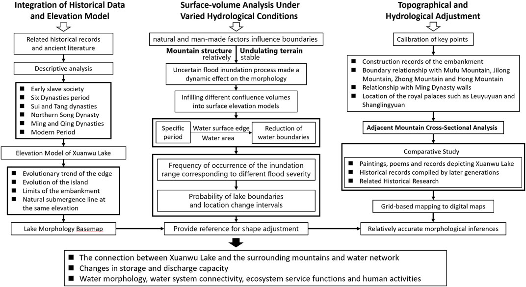
Figure 1. The framework for reducting the historical shape of Xuanwu Lake through the combination of historical interpretation and geographical analysis.
2.1 Formation of lake morphology basemap based on historical material interpretation and elevation calibration
The foundational spatial reference for lake morphology was developed through a rigorous interpretation of historical texts and maps, resulting in the creation of a comprehensive basemap delineating the lake’s shape. This process was followed by the construction of a surface model to identify relatively stable surface undulations and ridge structures, which served as geographical references for calibrating the lake’s morphology.
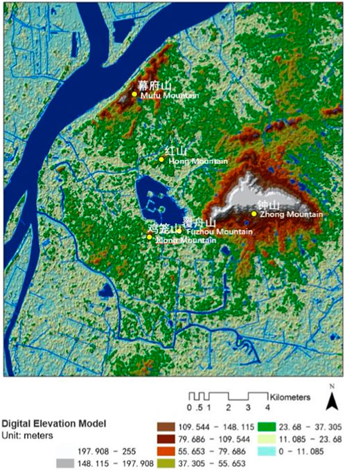
Initially, a descriptive analysis and systematic review of primary historical documents and cartographic materials provided a foundational spatial location of Xuanwu Lake’s morphology and boundaries over various historical periods. This analysis offered a generalized depiction of the lake’s spatial structure at specific times. Given that landforms, terrains, and mountain patterns change more gradually compared to built structures such as palaces, buildings, and roads, the study utilized relatively stable spatial elements—such as actual terrain and mountain configurations—as reference points. By refining roughness and resampling, a surface elevation model reflecting the overall topographic variations were developed (Cheng and Wang, 2021), as Figure 2. Natural inundation lines at elevations matching key reference points were employed to calibrate the lake’s morphology, as Figure 3.
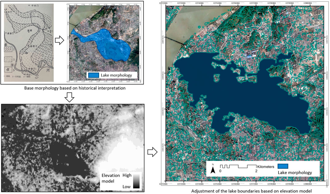
Figure 3. Lake morphology basemap based on historical material interpretation and elevation calibration.
The research traced the historical evolution of Xuanwu Lake from the earliest identifiable period, using structural changes as indicators to delineate different phases. Morphological features from various periods were digitized into maps using ArcGIS, based on historical records, local gazetteers, and related literature. By integrating urban development and historical events, the study inferred the lake’s evolution, changes in its area, and the conditions of its islands and embankments.
2.2 Assessing uncertainty in lake morphology based on probability density
In historical studies, the uncertainty associated with water body morphology stems from a myriad of complex factors. Both natural and anthropogenic environmental changes impact the boundaries of these water bodies. For Xuanwu Lake in a relatively natural environment, uncertain flood events exerted dynamic influences on its morphology throughout different periods. Positioned between Red Mountain to the north, Zhong Mountain to the east, Jilong Mountain and Fuzhou Mountain to the south, the lake’s mountainous and topographical features have remained relatively stable over time. Consequently, the floodplain dynamics of this natural lake have had a pronounced effect on its edges.
To address this complexity, the study utilizes probability density assessments to quantify the uncertainty in lake morphology. Building upon historical material interpretation and elevation calibration, the research computes runoff volumes under various storm recurrence intervals and applies the surface volume method to map the water extent across different flood scenarios. Probability density evaluations of the lake’s boundaries are conducted based on the frequency of inundation events, as Figure 4. The surface volume method, an approximation algorithm, uses surface elevation data to progressively fill the model with varying runoff volumes, refining calculations to approximate the water surface extent. By employing inversion techniques of surface volume filling, the study reconstructs the water body boundaries that align with specific historical periods. Based on the frequency of inundation areas corresponding to different storm recurrence intervals, the research assesses the variability in lake boundary positions and their likelihood, thus enhancing boundary accuracy and providing a basis for subsequent morphological refinements.
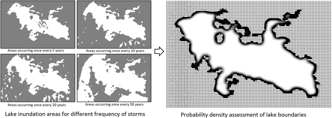
Figure 4. Probability density assessment of lake boundaries based on inundation areas for different frequency of storms.
2.3 Adjusting lake morphology boundaries based on adjacent mountain cross-sectional analysis
To delineate the boundaries of Xuanwu Lake in relation to nearby topographical features such as Mufu Mountain, Zhong Mountain, Hong Mountain, and Shijing Mountain, this study employs cross-sectional analysis of these adjacent mountain ranges. This approach deepens the understanding of the interactions between the lake and its surrounding environment. Using interpolation methods based on relatively accurate landmark positions (Cheng and Wang, 2021), the study adjusts the lake’s morphological boundaries, as Figure 5. By integrating historical elements such as the Ming city walls, Xuanwu Lake’s embankments, Leyou Garden, and Shanglin Garden, the study contrasts vector information from various historical periods to verify consistency with textual descriptions, thereby achieving a more accurate morphological reconstruction. The study performs a comparative analysis of multiple historical sources, including later compilations and research literature, overlaying historical information to refine and correct the boundaries based on the ratio of spatial element changes. Building upon this morphological reconstruction, the research explores the lake-mountain relationship, river-lake interactions, and the evolution of inflow and storage capabilities of Xuanwu Lake. It also examines the lake’s water body transformation and its structural connections with the urban water network, further investigating the dynamic relationships between the lake’s water morphology, connectivity of water systems, and urban water relationships.
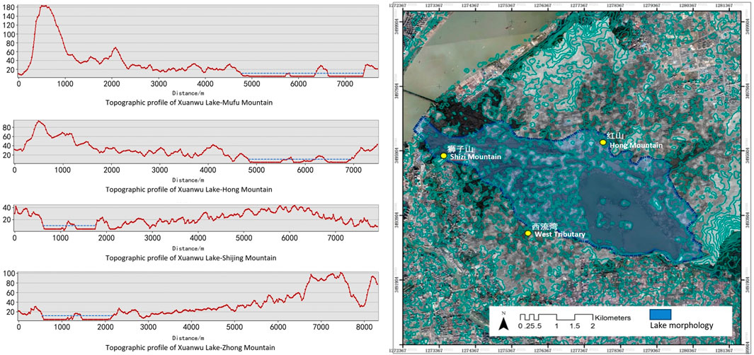
Figure 5. Adjustment of lake morphology boundaries based on analysis of neighboring mountain profiles.
Overall, by vectorizing information and reconstructing spatial elements, this approach provides a historically accurate representation of Xuanwu Lake’s morphology. It enhances the accuracy of morphological representations, mitigates conflicts between historical data and actual terrain, and compensates for historical inaccuracies. This method offers a clearer, more detailed depiction of the lake’s evolutionary process, facilitating both visual representation and in-depth analysis.
3 Results: inferring the spatial pattern changes of Nanjing Xuanwu Lake based on geographical information
Through the interpretation and reorganization of historical records and geomorphological information, the evolution of the spatial pattern of Xuanwu Lake is traced to restore and rectify its lake morphology, reflecting the spatiotemporal changes in the relationship between the city and water.
3.1 The early period of slave society: lakes formed by mountain runoff under natural processes
The exact formation time and hydrological conditions of Xuanwu Lake are difficult to ascertain. Whether it originated as the ancient Oxbow Lake (Zongyi and Yihua, 2011) in the old course of the Yangtze River, as a sedimentary lake left by the ancient Qinhuai River, (Nai and Yanzhao, 2011), or as a tectonic lake formed by the Daxing Mountain fault (Le, 2014), it eventually became known as a “Sangbo Lake” according to historical records (Jiang et al., 1986), indicating a natural water area. (Figures 6, 7). During the pre-Qin period (Xu, 2020), the geographic location of Xuanwu Lake was relatively consistent with that of the Six Dynasties (Yuli and Song, 2022-0). It extended south to Fuzhou Mountain and Jiming Mountain and east to Zhong Mountain (Wei, 2012). Morphological reduction of Xuanwu Lake in early slave societies based on the integration of historical interpretation and geographic analysis is shown in Figure 5.
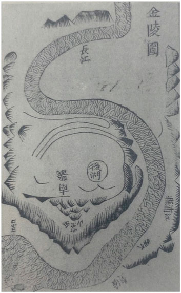
Figure 6. Map of Jinling, depicting the landscape relationship between the Yangtze River, Zijinshan Mountain and Xuanwu Lake. Source: Shanji Xu, Shanshu Xu, What a Geographer Needs to Know, World Knowledge Publishing House, 2011, available on open source website Chinese Repository Library.
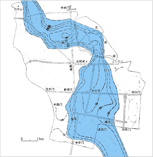
Figure 7. Relationship between the ancient Qinhuai River and the present-day Xuanwu Lake, redrawn from the bedrock isobath map of ancient river channels in Nanjing, China. Jiang Si Shan, Ang Chao Hai, Yang Huicheng, et al. A preliminary study on the paleochannels and the age of sediments in the Qinhuai River, Nanjing. Journal of Geology, 1986(01):91-103.
Emperor Qin Shi Huang started the excavation of Fang Mountain in 210 BC to release the “royal air,” allowing the Huai River to flow through Jinling City. Jinling City was subsequently renamed “Moling City”, while the “Sangbo Lake” was renamed Moling Lake.17 At that time, the hydrological processes within the Xuanwu Lake basin area were minimally influenced by human activities, maintaining the natural runoff characteristics and connectivity with the Yangtze River. The lake area had abundant water resources, receiving rainwater runoff from the northern foothills of Zhong Mountain. The dynamics balance between the inflow and outflow of the small watershed endowed the lake with certain storage and discharge capacity. The surrounding residents simply enjoyed the water ecosystem services provided by the lake.
3.2 The six dynasties period: xuanwu lake under the influence of the sacred mountain and immortal island theory
During the Six Dynasties period, Nanjing was established as the capital city (Figure 8). With the development of agricultural civilization and the increase in urban population, the hydrological condition and water functions of Xuanwu Lake underwent certain changes due to small-scale utilization, transitioning from a natural lake to an increasingly urban lake influenced by human activities. At this time, Xuanwu Lake extended eastward to the northwest foothills of Zhong Mountain, northward to Gulou Hill, and westward to the present-day Xiliuwan Park (Li, 2022). The Morphological Reduction of Lake Xuanwu in the Six Dynasties is shown in Figure 9.
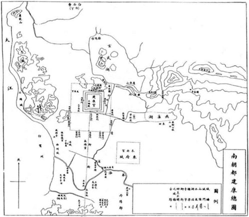
Figure 8. General map of Jiankang, the capital of south China, depicting the city’s relationship with Xuanwu Lake and the surrounding landscape. Source: Zhu Qian, Jinling Ancient Monuments Map Kao, China Bookstore, 2006, available on open source website Chinese Repository Library.
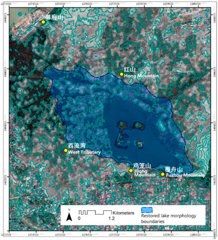
Figure 9. Morphological reduction of lake Xuanwu in the six dynasties based on the integration of historical interpretation and geographic analysis.
In 229 AD, Sun Quan relocated the capital to Jianye, marking the beginning of Nanjing’s foundation as a capital city.18 During this period, various embankments were constructed and maintained. Xuanwu Lake served purposes such as military reviews and martial arts training, providing water for the urban water system and imperial gardens. In the second year of Emperor Wu’s reign19, known as Chih-Wu Era, a Chao Channel20 was excavated to divert water from Xuanwu Lake into the palace complex (Lu, 2019). From then on, Xuanwu Lake was connected to the Yangtze River, ensuring abundant water supply for both the city and the Qingxi River outside the city. Xuanwu Lake maintained the water balance of the capital city of Jianye through its own hydrological cycle.
The “Jingding Jiankang Zhi21” records, “In the fourth year of Chih-Wu era in Wu Dynasty, the Qingxi canal was dug, releasing water from the back lake. In the second year of Emperor Sun Hao’s Baoding era, a northern canal was built, redirecting water from the back lake into the new palace, encircling the palaces, and thus gaining its name (Zhou, 2008).” Both the urban water system of Jianye and the new palace relied on Xuanwu Lake. In the third year of the Daxing period of the Eastern Jin Dynasty22, Emperor Yuan23 began constructing North Lake and built a six-li (approximately 3 km) long embankment. Historical records state, “The long embankment was built to dam the waters from the northern mountains. It extended from Fuzhou Mountain in the east to Mufu Mountain in the west, a distance of over six li.” The southwest shore of Xuanwu Lake was enclosed by the embankment, altering the natural hydrological processes along the shoreline.
Later, Emperor Wen24 of the Song Dynasty established three divine mountains25 in the lake (457 AD) and four pavilions, integrating Xuanwu Lake into the imperial gardens. During this period, the theories of divine mountains and immortal islands, as well as the beliefs in immortals and adepts, flourished. In this cultural context, Xuanwu Lake was developed through hydraulic dredging, resulting in islands within the water. Xuanwu Lake can be regarded as ‘One Pool and Three Mountains' of Nanjing. The “Nan Shi (Southern History)26” states, “In the 20th year of Yuanjia, a northern embankment was built, establishing Zhenwu Lake in the Leyou Garden to the north, with four pavilions within the lake.” The construction of the northern embankment was primarily aimed at preventing water leakage from Xuanwu Lake and raising the water level, resulting in an area reduction. At this time, both the southern and northern shores of Xuanwu Lake had embankments, gradually shaping the natural hydrological processes of the lake through human intervention.
Xuanwu Lake has served as a battlefield for military conflicts and a training ground for naval forces on multiple occasions (Chen, 2016). During the Liu Song dynasty, when Xiao Daocheng held the position of Minister, he stationed troops at Xuanwu Lake and defeated Prince Jianping, Liu Jingsu.27 In the 11th year of the Taijian era of Emperor Xuan of the Chen dynasty, he ordered the commander Ren Zhong to lead an army of a hundred thousand infantry and cavalry to form a grand martial display on the surface of Zhenwu Lake.28 Towards the end of the Liang dynasty, during the prolonged siege of Tai City by Hou Jing, who failed to capture the city, it was decided to take advantage of the water level difference between Xuanwu Lake and Tai City.29 The decision was made to breach Xuanwu Lake’s embankment and flood Tai City with the rushing waters. The majestic waves of the lake surged towards Tai City, causing water levels to rise both inside and outside the city, transforming the palace and royal avenues into torrents under the impact of Xuanwu Lake’s forceful assault.
3.3 Sui and tang dynasties: low interference evolution of Xuanwu Lake as a far countryside natural place
After the unification of the Sui Dynasty30, Jiankang City, adorned with numerous palaces, was reduced to rubble in order to completely eradicate the royal aura of Jinling. Buildings were demolished and the land was reclaimed as fields, a process known as “Pingdang Gengken” or “leveling and cultivation.” As the capital cities of the Six Dynasties fell into silence, Xuanwu Lake also became desolate and deserted. In the fourth year of the Tianxi era of the Song Dynasty31, it was renamed as the “Fangsheng Pond,” symbolizing the emperor’s benevolent virtue of showing compassion towards plants and animals, thereby manifesting the imperial reverence for the spirits of nature. “The moon shines over the vacant rear lake, waves rippling towards Yingzhou Island.32” Consequently, Xuanwu Lake underwent more than three hundred years of natural evolution, eventually becoming a suburban lake during the Five Dynasties period33. It harmoniously blended with the surrounding landscape, including Jiang Mountain, Jilong Mountain, and Mufu Mountain (Zhen, 2010). “To the north of Jinling lies a lake, stretching for dozens of miles. Mufu and Jilong Mountains encircle it from the west, while Zhongfu and Jiang Mountains proudly stand on its left. These renowned mountains and grand rivers form a picturesque panorama.34”
3.4 Northern song dynasty: the abandonment of lakes and agricultural reclamation resulting in the conversion of lake water release into farmland
Due to the development of agrarian economy during Northern Song Dynasty35, Xuanwu Lake was frequently filled and its hydrological processes were greatly disrupted. The primary function of the water system was irrigation for agricultural purposes, with the water level fluctuating between seven to four feet annually36. As the agrarian economy continued to grow, the demand for irrigation increased, prompting further landfilling of Xuanwu Lake. Unable to maintain its own water balance, the lake started experiencing siltation and water depletion, eventually transforming into arable land. Subsequently, the area of Xuanwu Lake gradually shrank, but remnants of the water body remained. (Figure 10).
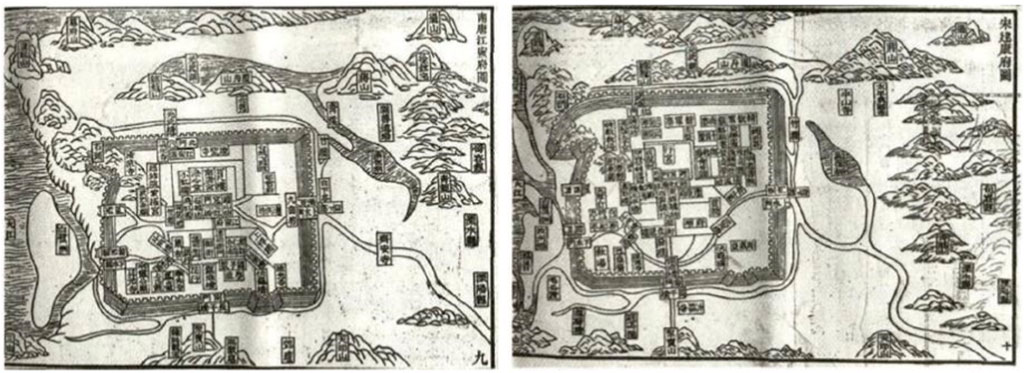
Figure 10. “Map of Jiangning Prefecture in Nankang” and “Map of Jiankang Prefecture in Song”, comparing the changes of Jiankang City from the Southern Tang Dynasty to the Song Dynasty period. Source: Chen Yi, Ancient and Modern Map of Jinling, Nanjing Publishing House, 2017. Available in the Chinese Library of the School of Diagram and Architecture, Southeast University.
However, the lake suffered the most substantial anthropogenic disturbance in history – “Xie Hu Wei Tian”or “Draining the lake as farmland”. In the eighth year of Xining37 during the Northern Song Dynasty, Wang Anshi, the magistrate of Jiangning Prefecture, obtained permission from Emperor Shenzong to convert Xuanwu Lake into farmland.38 Two hundred hectares of land were distributed among the impoverished and famished people for cultivation (Jun and Zhao, 2022). The waters of Xuanwu Lake were drained, leaving only a cross-shaped canal for irrigation purposes. Morphological Reduction of Lake Xuanwu in the Northern Song Dynasty is shown in Figure 11. Consequently, Xuanwu Lake completely disappeared for over two hundred years. This drastic human intervention severely damaged the aquatic ecosystem of Xuanwu Lake, causing a discontinuity in the hydrological processes within the basin and the inability to sustain rainwater-harvesting functions.
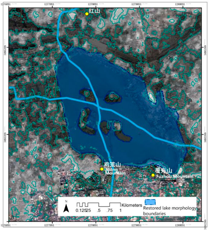
Figure 11. Morphological reduction of Lake Xuanwu in the northern song dynasty based on the integration of historical interpretation and geographic analysis.
Originally interconnected with numerous water networks inside Nanjing City, Xuanwu Lake continuously supplied water to the city, mitigating river tides and mountainous runoff during heavy rainfall. This ensured the city’s safety against floods and provided a reservoir for water storage. However, after being converted into agricultural land, the disruption of this beneficial water regulation process resulted in frequent siltation of the city’s waterways due to water scarcity during dry seasons and led to waterlogging during rainy periods. The loss of Xuanwu Lake’s aquatic ecosystem services dealt a heavy blow to Nanjing’s urban safety barriers.
3.5 Ming and Qing dynasties: restoration of Xuanwu Lake and its isolation as a royal sanctuary
After being turned into farmland, the waterways in Nanjing frequently silted up, prompting two major dredging efforts by the Yuan dynasty39 to restore the channels of Xuanwu Lake.40 Historical records in the third year of the Zheng dynasty, stating that “the Dushui Yongtian Bureau opened and dredged the waterways of the lake extending from Zhong Mountain’s Pearl Bridge to Jinling Longwan River, spanning seventeen li.” This dredging allowed the waterways to extend all the way to the present-day Qinhuai River41. Xuanwu Lake reappeared on the map of Nanjing, providing some relief from the problems of flooding and drought.
It was during the Ming dynasty42 that Xuanwu Lake truly regained its former glory, serving as the repository of the national household registrations and records of tribute and taxes for the Ming government—an esteemed place known as the Huangce Ku, or the Yellow Registry Warehouse43. (Figure 12). The Ming Dynasty Annals of Ying Tianfu44 recorded, “Under the rule of Zhao and Song, it was turned into farmland, and during the Yuan dynasty, it became a small pond. In the Ming dynasty, it was restored to become a lake, storing the maps and records of the whole country (Wang and Wang, 2002).” With dedicated personnel guarding the Huangce Ku house within Xuanwu Lake, it became an inaccessible forbidden lake. “Few have set foot in this treasury of maps, with only towers and pavilions against the setting sun.45” Xuanwu Lake once again evolved into a naturally balanced ecosystem, forming a harmonious relationship with the surrounding mountains of Mufu, Zhong, Fuzhou, and Jiming. (Figure 13). During the Zhengde era46, Ji Zongdao47, a junior official of the Ministry of Revenue, wrote in his “Passing Through Hou Lake48”: “I stood at the bow of the boat, gazing in all directions. To the southeast, there stood the towering Zhongshan Mountain, veiled in celestial majesty; to the northwest, mountain peaks rose like screens and curtains—Mount Mufu; the undulating ridges lay prostrated on the ground, covered with thick pine forests—Mount Fuzhou; and jutting out above the city walls, palaces and pavilions stood in disarray, with pagodas soaring into the sky—Mount Jiming Islands emerged from the water, their presence subtle amidst the fog and water.” After its natural restoration, Xuanwu Lake shimmered with lush vitality, showcasing the beauty of nature.
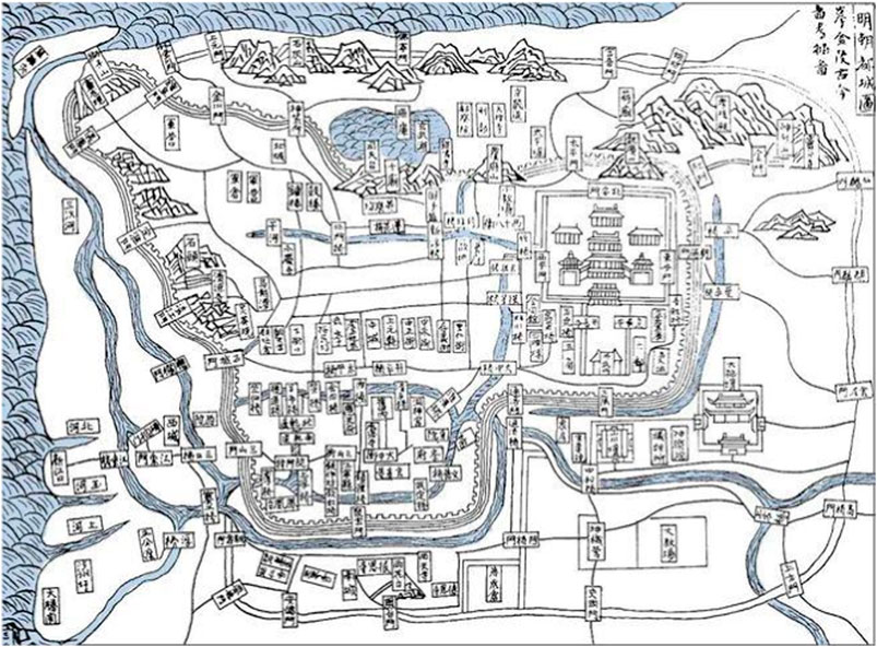
Figure 12. Back River map, depicting the distribution of islands and the relationship between the layout of depots on the islands when Xuanwu Lake was used as a yellow volume storehouse during the Ming dynasty. Source: Wang Qi, Wang Siyi, San Cai Tu Hui, Shanghai Ancient Books Publishing House, 1988.
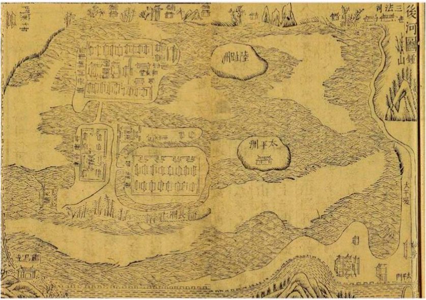
Figure 13. Map of the capital city of the Ming dynasty, depicting the relationship between Xuanwu Lake and the layout of the capital city and the structure of the landscape. Source: Written and revised by the Ministry of Rites of the Ming Dynasty, Hongwu Capital City Map, Nanjing Publishing House, 2006. Available in the Chinese Library of the School of Figure Architecture, Southeast University.
During the reign of Emperor Qianlong49 in the Qing Dynasty50, Xuanwu Lake became one of the “Forty-eight Scenes of Jinling,51” earning the name “North Lake Veiled in Mist and Willow.52” Emperor Qianlong established his palace53 on the northern shore of Xuanwu Lake, leaving behind numerous poetic works that extolled the pristine waters and natural splendor of this scenic landscape. One verse reads, “Here I stand, marveling at the vast expanse, where Xuanwu’s clarity reveals its depths,54” while another paints a vivid picture, stating, “The mirror-like surface embraces the depth of spring waters, with white aromatic plants and green cattails adorning the azure banks.55”
In the late Qing Dynasty56, notable figures like Zeng Guofan57 undertook the construction of various facilities around Xuanwu Lake. The renowned Zeng’s Embankment58 was built between Guqi Slope and Liang island, while the Fengrun Gate59 was erected atop the Ming city wall. Additionally, a new embankment was constructed, accompanied by an expansion of the lake’s green spaces. Lu Shi Xue Tang Newly Measured Complete Map of Jinling Provincial Capital comprehensively reflects the layout of streets and alleys of Nanjing city. (Figure 14). These efforts marked the transformation of Xuanwu Lake into a modern-day park, providing the city with a plethora of invaluable ecological services owing to its favorable landscape conditions.
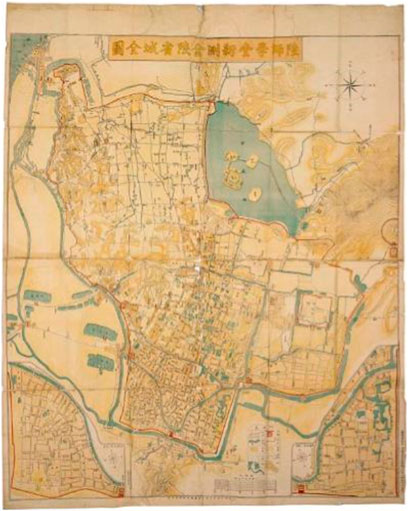
Figure 14. Lu Shi Xue Tang Newly Measured Complete Map of Jinling Provincial Capital, a map comprehensively reflecting the layout of streets and alleys of Nanjing city, drawn by Zhong Bingxi and Li Delin, graduates of Jiangnan Lu Shi Xue Tang, under the order of Liu Kunyi, the Governor of the Two Rivers. Source: “Old Maps, Old Shadows of Nanjing: 1903 Newly Surveyed Complete Map of Jinling Provincial City by the Land Division School”, Nanjing Publishing House, 2014.
3.6 Period since modern times: urban garden relying on artificial maintenance of water quantity and quality
In modern times60, with China's opening up, Xuanwu Lake has been referred to as ‘Wuzhou Park,’ which is distinctly different from the concept of immortals. The term ‘Wuzhou' not only denotes the five islands of Xuanwu Lake but also embodies the idea of ‘five continents and four oceans' on a global scale. During this period, Xuanwu Lake became a highly popular urban park in Nanjing. However, as urban construction in Nanjing expanded, many lakes were filled in, leading to siltation and a reduction in size, with Xuanwu Lake being no exception (Geng, 2019). To restore the vitality of Xuanwu Lake, extensive dredging was carried out in the 1950s. However, the sediment from the dredging encroached upon a portion of the lake’s surface, resulting in its compression to the west of Zeng’s Embankment and further reduction in size. In 1960, to improve connectivity within Xuanwu Lake, long embankments were constructed on the north side of the lake, connecting Cui island and the lake shore, Huan island and Ling island, as well as Ling island and the lake shore. These embankments facilitated transportation between the various islands of Xuanwu Lake. Morphological Reduction of Lake Xuanwu in the Qing Dynasty (A) and the 1960s (B) is shown in Figure 15. In the 1990s, Xuanwu Lake lost an area of nearly 50,000 square meters due to urban development, which displayed a strong tendency to encroach upon the lake. This led to a decrease in the effective convergence space of the watersheds, the interruption of runoff pathways, and a gradual weakening of the connection between Xuanwu Lake and its surrounding water systems. As a result, the lake’s water storage capacity diminished, leading to frequent occurrence of urban waterlogging.
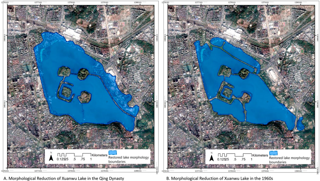
Figure 15. Morphological reduction of lake xuanwu in the qing Dynasty (A) and the 1960s (B) based on the integration of historical interpretation and geographic analysis.
The discharge of domestic and industrial wastewater from urban activities has also significantly impacted the ecological balance and self-purification capacity of Xuanwu Lake. By the mid-1980s, the lake water began exhibiting signs of organic pollution and eutrophication. In the 1990s, eutrophication worsened, resulting in extensive fish mortality. In 1998, the Comprehensive Remediation Project of Xuanwu Lake was initiated, which included a water diversion project with an annual total water intake exceeding 70 million tons, averaging approximately 220,000 tons per day.
Today, Xuanwu Lake relies on the Comprehensive Remediation Project to replenish water volume and improve water quality. It maintains a relatively stable ecosystem and satisfies the aesthetic and recreational needs through a large amount of water flushing from the Yangtze River and periodic sediment dredging. However, Xuanwu Lake is still in a “sub-healthy” state, with its water often experiencing mild to moderate eutrophication.
4 Discussion: evolution of the spatial pattern of Xuanwu Lake and the relationship between city and water
The ancient cities, palaces, and water systems of China were intricately tied to the culture of feng shui. As a renowned and mysterious Chinese tradition, feng shui encompasses a conceptual and practical system based on geographic environment, energy flow, and aura. Its main focus is on how the arrangement and adjustment of surroundings can positively influence human life and the development of various entities. However, when examining Xuanwu Lake, it becomes evident that historical Chinese urban water layouts were more pragmatic, emphasizing adaptation to the local conditions.
China has a large number of famous historical and cultural cities, each embodying diverse synergies between urban landscapes and water systems, facilitating sustainable development. The functions of these water systems have evolved in tandem with urban development. With the widespread implementation of modern municipal infrastructure and diversified transportation methods, the once prominent roles of waterways for transportation and agricultural irrigation have gradually diminished, shining a greater spotlight on the ecological role of urban water networks. In the case of present-day Xuanwu Lake, its original functions in military training, transportation, agricultural irrigation, and water supply for daily use have faded away, leaving behind its ecological significance as maintenance of landscape connectivity. This indicates the shift from productivity-oriented purposes to prioritizing the hydrological regime and water ecological safety, whilst emphasizing the nurturing effects of water on the surrounding environment and its ecological service functions. This perspective provides valuable insights into the changing dynamics of urban water relationships in Xuanwu Lake from a historical standpoint.
4.1 Changes in the spatial pattern of Xuanwu Lake
The development and utilization of Xuanwu Lake by humans have led to numerous alterations, disappearances, and reappearances, driving the contraction and expansion of the lake’s edge in different periods. Originally, when carefully shaped by humanity, Xuanwu Lake existed as a natural and complete body of water, unobstructed by dams or islands, with a pristine shoreline. Historical records indicate that the lake’s area was once four times its current size. Subsequently, two river embankments were constructed, and three islands were created within the lake, enhancing the complexity of the water’s morphology and resulting in a more meandering shoreline.
After experiencing transformations such as turning the lake into farmland and expanding it through land reclamation, the lake’s area was reduced by two-thirds. During this process, bridges and embankments were introduced to partition the water surface, and the number of islands increased. Following the Republican period61, significant contraction of Xuanwu Lake’s shape became evident. In the 1980s, there were frequent incidents of encroachment and artificial landscaping along the lake by various establishments, such as the occupation of the lake by water sports schools, filling of the lake for golf courses, and encroachment by Xuanwu Gate Square and Lotus Square. As a result, the lake’s circumference decreased from 12 to 9.5 km. In modern times, the shape of the lake’s shoreline has been further influenced by urban development, causing Xuanwu Lake to gradually diminish due to dredging and land utilization.
Initially, the water morphology of Xuanwu Lake represented a primary expanse with winding contours. Subsequently, the water surface became more diverse, featuring sporadic bridges, embankments, and islets, without dominating the overall water area. In the later stage, the water surface exhibited greater diversity, with larger areas occupied by islets and embankments in the central region. Finally, the lake contracted along its edge, increasing the island area within, elevating the overall marginality of the lake’s shoreline while reducing its centrality and aggregation. The general form of the lake tended toward regularity, with the most notable changes occurring adjacent to the western side of the Ming City Wall.
4.2 Changes in the connectivity of Xuanwu Lake and Nanjing’s water system
According to historical records, Xuanwu Lake was originally connected to the Jinchuan River system62 to the south and the Yangtze River to the west. The “Jiaqing Jiangning Prefecture Chronicles63” states: “Zhidu River, now known as Guanyin Gate, flows into the Yangtze River. South of Maigao Bridge, water flows through Santa Temple into Back Lake, where it meets the waters of the mountains northeast of Zhong Mountain and flows westward through Dashuiguan and Fu Family Bridge (which should be located east of today’s Mufu Mountain) into the Yangtze River (Yao and Lv, 2001).” In the depression between Lion Hill and Mufu Mountain, there was a gap approximately four to 5 km wide, through which the rising tide of the Yangtze River surged into Xuanwu Lake. Emperor Chen Xuan64, sitting atop the North Gate, reviewed a procession of 100,000 soldiers and cavalry advancing toward the foot of Zhongshan via Jimingdai, while 500 warships sailed in various formations into the Yangtze River. This grand spectacle demonstrates the wide passage between the Yangtze River and Xuanwu Lake at that time, with expansive water surfaces and navigable channels.
In the early days, the connectivity of Xuanwu Lake’s water system was excellent, as the water from Zhongshan continuously flowed into the lake. It converged through Chaogou, joining the Pearl River65 and Yangwu Yundu before entering the Qinhuai River on the eastern side of Jilong Mountain. The “Tai Ping Huan Yu Ji66” accurately locates Qingxi: “Qingxi is located six miles north of the county to drain the water from Xuanwu Lake and flow south into the Qinhuai River (Le, 2014).” The “Annals of Jiankang67” provides a clear position on the relationship between Qingxi, Yundu and Chao channels: “Qingxi flows eastward connects with Yundu, entering the Qinhuai River. Another canal is opened, leading north to Houhu, to direct the lake water. The eastern outlet to Qingxi is a tidal channel (Xu, 2020).” Xuanwu Lake, through the influx of the Yangtze River, the connection with Yundu, the communication with Qingxi, and its arrival at the Qinhuai River, also provided various water sources for the surrounding areas, including the imperial gardens such as Leyou Park and Hualin Garden, forming an interconnected water network that constitutes the main urban area of Nanjing.
When Zhu Yuanzhang68 established his capital in Nanjing, he built the city walls on the southern and western shores of Xuanwu Lake. Xuanwu Lake, serving as a natural “protective moat,” separated the lake from the city walls and effectively cut off its previous connection to the Yangtze River. Moreover, at the junction of Zhongshan Mountain and Xuanwu Lake, the “Taiping Embankment” was constructed. This embankment divided a section of the lake that was adjacent to the western slope of Zhongshan Mountain, creating what is now known as Baima Lake. As a result, the direct hydrological connection between Xuanwu Lake and the western slope of Zhongshan Mountain was severed. The establishment of Huangceku further limited the connectivity between Xuanwu Lake and the surrounding water systems. To ensure the safety of Huangceku, the water flow and level of Xuanwu Lake were tightly controlled. At that time, there was a water gate called Dashugen69 on the west side of Xuanwu Lake, which connected to Jinchuan River, and the Jinchuan River flowed into the Yangtze River. The protective moat outside the northwest and Shence Gates70 formed a connection, while to the south, through Wumiao Gate71, Chao channels were introduced, linking to Qingxi and later flowing into Qinhuai River. The lake water served as a protective barrier for Huangceku. The opening and closing of the gates were strictly regulated to maintain a balanced water level and appropriate water volume in Xuanwu Lake.
With the development of modern construction, pollution sources, including domestic pollution around Xuanwu Lake and the discharge of agricultural and industrial wastewater along the lake, have increased. Surface runoff quality has declined, and the interconnected water systems have transferred pollution from the city to Xuanwu Lake. In order to control external pollution of the lake water, the existing Tangjia mountain and Zijin mountain diversion channels have been blocked, preventing the runoff from the northern foot of Zijinshan and the northeast watershed from replenishing Xuanwu Lake. Overall, Xuanwu Lake has no self-sustaining water sources. It is completely dependent on the pumping of water from the Yangtze River, and water discharge is regulated through the gates.
In history, Xuanwu Lake used to rise and fall with the Yangtze Rive. In different periods, Xuanwu Lake provided water for various internal and external water systems, such as Yundu River, Qingxi River, Chengbei River72, Qianbei Ditch, Tidal Channel, and Pearl River. However, nowadays, the tidal channel and Xuanwu Lake are separated, and the network of water systems within the watershed appears obstructed and fragmented when observed from satellite images. Multiple branches of the interconnected water systems have been converted from surface runoff to underground pipelines. As a result, the connectivity of Xuanwu Lake’s water system has significantly decreased in modern times.
4.3 Evolution of city-water relations and human activities
The ancient Xuanwu Lake provides high-quality ecosystem services: pleasant climate, clean water resources, abundant shoreline vegetation, and diverse aquatic animals. People have settled around the lake, benefiting from Xuanwu Lake’s provision of high-quality living materials and a livable environment. Furthermore, the expansive water surface of Xuanwu Lake serves as a training ground for the navy, leading to human interventions to improve its edges, increase connectivity with the water system, and change the landscape—primarily driven by political reasons.
After being incorporated into the Royal Gardens, the Shanglin Garden, Leyou Garden, Hualin Garden, and the “Three Gods Mountain” in the middle of the lake, all relying on Xuanwu Lake, became places for daily royal recreation and hosting large-scale events, providing diverse cultural services. The lake and mountain pattern surrounding Xuanwu Lake, along with the water network, collectively serve as excellent barriers for defending Jiankang City in times of war.
However, with the onset of economic development, the ecological services provided by Xuanwu Lake were not fully recognized, leading to the lake being used for agriculture through drainage, disregarding its role as a reservoir and undermining its functionality.73 This practice has subsequently resulted in numerous flood and drought problems. “Jinling’s land is high on the outside but low in the middle. Xuanwu Lake, though it receives water from the various streams of Beishan, suffers from storage loss, rendering it useless in times of drought or flood.74” The reasons behind this lie in the fact that although Xuanwu Lake has been transformed into farmland under human control, it still remains in a low-lying terrain. Water from Zijin Mountain and Mufu Mountain continues to flow into the area, and the gap leading to the Yangtze River has been filled, causing poor drainage and making it prone to waterlogging. After the construction of city walls, water from Xuanwu Lake could directly protect the northeast of Nanjing City, while the west and north sides of the city were adjacent to the Yangtze River, providing natural defense. The imbalances within the aquatic ecosystem of Xuanwu Lake resulted in the breach of the city’s safety barrier, leading to both drought and flood disasters. Thus, these urban calamities have prompted efforts to restore Xuanwu Lake once again.
During the Ming Dynasty, Xuanwu Lake, as part of the imperial Yellow Registry, served as a secluded royal sanctuary, cut off from the outside world. The primary function of Xuanwu Lake during this period was spatial isolation. The location of the Yellow Registry on the central island of Xuanwu Lake was chosen for several reasons. Firstly, its proximity to the capital city facilitated easy transportation. Secondly, its enclosed surroundings made it convenient for administration. Lastly, the three islands surrounding the water provided natural protection against fires.
After its reopening, Xuanwu Lake’s recreational and cultural value was fully realized, leading to a new phase of development and refurbishment. In 1872, Zeng Guofan oversaw the restoration of the Lake Temple in Liangzhou and the construction of landmarks such as Hu Xin Pavilion and Da Xian Tower. To address the issue of difficult access to Taiping Gate, Zuo Zongtang75 constructed a long embankment connecting Guqi Geng to Liangzhou. Zhang Zhidong76 erected the “Chu Ri Fu Rong” archway along this embankment. Duan Fang77 expanded the green spaces within the lake, opened Fengrun Gate, and built new embankments. These initiatives significantly enhanced the recreational services of Xuanwu Lake.In 1946, Chiang Kai-shek returned the capital to Nanjing78, and Xuanwu Lake became the political and cultural epicenter of the city. It served as a gateway for international cultural exhibitions and various diplomatic exchanges.
Following the era of reform and opening up, Xuanwu Lake transformed into an urban landscape. Its high-quality recreational services led to the addition of facilities and the renovation of buildings. However, simultaneous development of surrounding construction sites had a disruptive impact on the ecological system of Xuanwu Lake. Over the past 3 decades, the water quality of Xuanwu Lake has declined, and its aquatic ecosystem has deteriorated. Contemporary efforts are being made to explore sustainable ways to enhance the water environment of Xuanwu Lake and its surrounding water system, aiming to strengthen its ecological resilience. The relationship between the city and Xuanwu Lake has been closely intertwined with political and economic changes, exerting mutual influence over the long term.
4.4 Comparative analysis of historical evolution and city-water relationships between Xuanwu Lake and Hangzhou’s West Lake
Xuanwu Lake and Hangzhou’s West Lake provide a rich comparative framework for examining their historical development and the evolution of urban-lake relationships. This analysis seeks to explore the complex interplay between lakes and urban environments, contributing to reflections on sustainable urban development.
In contemporary settings, Xuanwu Lake and West Lake reveal striking contrasts in their urban water relationships and social service functions. These differences primarily arise from the positional relationship of Xuanwu Lake relative to Nanjing and the structural variations within the city. Originally serving as a water source and defensive moat, Xuanwu Lake, situated as the “back lake,” was isolated beyond the city walls. Initially conceived as a defensive barrier, it gradually transformed into a royal garden and eventually emerged as a significant public open space. Prior to Nanjing’s rapid land development, Xuanwu Lake resembled a garden for the city. In contrast, West Lake serves as a quintessential “inner lake,” deeply integrated into the daily life of Hangzhou’s inhabitants. Its spatial relationship with the city embodies a “city-water synergy,” with both commercial and residential developments clustering around it. This arrangement has substantially enhanced the quality of urban spaces in its vicinity.
In history, Xuanwu Lake and West Lake have experienced markedly different trajectories. As previously discussed, Wang Anshi’s reforms during the Song Dynasty drastically altered Xuanwu Lake by transforming it into arable land. Similarly, West Lake underwent significant intervention during the ancient period, by the Northern Song scholar Su Shi. In 1,090, as Governor of Hangzhou, Su noticed the lake’s deteriorated state, which had become overrun with weeds and silted from years of neglect. Su petitioned Emperor Zhezong with a proposal for the lake’s revitalization, stating, “The success or failure of water management appears to be governed by natural and human principles. However, a discerning ruler who understands the times and invests in water projects to benefit the populace and mitigate disasters ensures that such measures yield visible results and are difficult to reverse.” Utilizing imperial permits for tax exemption, Su secured funding for the lake’s restoration. He organized manpower and resources to remove silt and vegetation, thus restoring the lake’s original expanse. Additionally, he constructed the “Su Causeway” using the removed silt and vegetation, which featured six bridges to facilitate transportation and enhance the lake’s aesthetics. Furthermore, Su established a dedicated agency for the lake’s dredging and maintenance, ensuring the long-term effectiveness of the restoration efforts. His initiatives not only resolved practical issues but also imbued West Lake with distinctive cultural significance.
Wang Anshi and Su Shi exhibited marked differences in their approaches, methodologies, and outcomes regarding lake management, resulting in the distinct historical trajectories of Xuanwu Lake and West Lake. Wang’s governance philosophy tended towards pragmatism with a focus on immediate gains. In managing Xuanwu Lake, he adopted a strategy of “draining the lake to create farmland,” aimed at expanding agricultural land. However, this approach neglected the lake’s ecological significance and its long-term impact on the city, leading to Xuanwu Lake’s disappearance for over two centuries and exacerbating severe flooding and drought issues. In contrast, Su prioritized ecological balance and cultural sensitivity in his management of West Lake. He advocated for a harmonious integration of water management and ecology, sought extensive public input, conducted thorough field surveys, and developed a practical and sustainable management plan. This approach not only preserved West Lake’s ecological integrity but also enhanced its role as a significant cultural and tourist resource, thereby fostering urban economic development.
A deeper examination of these differences reveals that they stem from the individual backgrounds and values of the administrators. Wang Anshi, the initiator of the “Xining Reform” (1,069–1,085), aimed to rectify the impoverished state of the Northern Song Dynasty through a series of reformative policies and measures. Facing substantial political pressure, Wang was urgent in seeking immediate results. Conversely, Su Shi operated within a relatively stable environment, allowing him to consider long-term benefits more thoroughly.
Overall, Xuanwu Lake, with its distinctive geographical location and historical context, became a crucial element of Nanjing’s urban spatial structure, while West Lake, with its integration into Hangzhou’s cityscape and rich cultural heritage, stands as a symbol of the city’s cultural identity. These cases reflect a profound interaction between urban spaces and water bodies with unique characteristics. Historical evolution underscores that successful management requires not only scientific decision-making and effective methods but also a deep understanding of ecological environment, alongside essential public participation and feedback mechanisms.
5 Contemporary insights into the management and optimization of the Xuanwu Lake water environment
The study takes a long view of the historical process, and restores the historical shape of Xuanwu Lake through information vectorization and spatial reconstruction based on the interpretation of historical materials, and visually expresses the edge characteristics of Xuanwu Lake, the connectivity of the water system, and the evolution pattern of its landscape pattern. Xuanwu Lake was a pristine pond in the early days, used as a training ground for the royal navy during the Six Dynasties, then as a royal garden, then filled in as a field during the Northern Song Dynasty, restored as a royal forbidden lake during the Ming and Qing Dynasties, and became a popular urban landscape in modern times.
Reflecting on history, over the past approximately 2,300 years for which records are available, Xuanwu Lake has maintained its long-term hydrological balance by collecting surface runoff from the surrounding areas and connecting with the water network. Ancient people engaged in a prolonged dialogue with the environment, fully exploring the various external benefits of Xuanwu Lake. However, when it comes to the contemporary water environment issues facing Xuanwu Lake, relying solely on engineering measures to address the problems of declining water quality and insufficient water quantity is merely a surface approach to restoration. The underlying causes of the decline in water environmental quality in Xuanwu Lake lie in the city’s development patterns and changes in ecological processes.
Generally speaking, the restoration of the hydrological processes of Xuanwu Lake remains fundamental to water environmental management. The synchronicity between the self-sustaining capacity of Xuanwu Lake’s water system, the changes in hydrological processes and connectivity of the water network is relatively favorable. To a certain extent, this indicates that the density of the water system in the Xuanwu Lake watershed, the effective connectivity of river channels, and the land use development of smaller watershed catchments should be key points of intervention for water environmental management in Xuanwu Lake. Therefore, the sustainable recovery of Xuanwu Lake requires attention to the underlying process mechanisms and causes of the issues, aiming to restore hydrological processes and reconstruct the spatial network of the water system through natural or quasi-natural methods. This will allow the basin’s water network to nurture the vitality of the lake, thus reviving the natural spirit of Xuanwu Lake.
Data availability statement
The original contributions presented in the study are included in the article/supplementary material, further inquiries can be directed to the corresponding author.
Author contributions
XW: Conceptualization, Data curation, Formal Analysis, Methodology, Software, Validation, Visualization, Writing–original draft, Writing–review and editing. YC: Conceptualization, Funding acquisition, Supervision, Writing–review and editing.
Funding
The author(s) declare that financial support was received for the research, authorship, and/or publication of this article. Supported by the National Natural Science Foundation of China under the “Theory and Methods of Urban Green Space Planning under Low Impact Development” (No. 51838003).
Acknowledgments
During the preparation of this work the authors used ChatGPT 4o mini in order to improve language and readability.
Conflict of interest
The authors declare that the research was conducted in the absence of any commercial or financial relationships that could be construed as a potential conflict of interest.
Publisher’s note
All claims expressed in this article are solely those of the authors and do not necessarily represent those of their affiliated organizations, or those of the publisher, the editors and the reviewers. Any product that may be evaluated in this article, or claim that may be made by its manufacturer, is not guaranteed or endorsed by the publisher.
Footnotes
1The Ming City Wall of Nanjing is one of the best-preserved and largest Ming Dynasty city walls in China. Constructed during the Hongwu period of the Ming Dynasty (1,368–1,398), the Ming City Wall is about 35.2 km long. The city wall boasts several gate towers and corner towers, as well as defensive facilities such as moats and trenches. The Ming City Walls were constructed with many rebuilds and expansions, and played an important role in military defense and administration throughout history. The moats surrounding the walls also provided an additional line of defense for Nanjing.
2Nanjing was once one of the important ancient capitals of China, and was particularly prosperous during the Ming and Qing dynasties. After moving the capital to Nanjing, Zhu Di, the first Ming emperor, embarked on a massive construction and restoration project, which included the construction of defenses such as city walls and gates. Over time, Nanjing gradually developed into a bustling urban center, and ancient streets, buildings and cultural relics accumulated to form the Nanjing Old Town.
3There are five existing islands in Xuanwu Lake, including Liang Island, Ying Island, Huan Island, Cui Island and Ling Island.
4Before the Qin Dynasty, Xuanwu Lake was called “Sangbo”, meaning natural lake.
5The founder of the Eastern Wu Dynasty (222–280 AD) was Sun Quan. His grandfather’s name was Zhong, so he renamed Zhongshan to Jiangshan to avoid the taboo, and at the same time changed the name of Moling Lake to “Jiangling Lake” and “Jiang Lake”. Because the lake is located in the north of Zhongshan (now Zijin Mountain), and in the southern foot of Zhongshan there is another Yanque Lake called “front lake”, so Xuanwu Lake is also called “back lake”.
6During the reign of Emperor Yuan of the Eastern Jin Dynasty, Xuanwu Lake was located in the north of the capital city of Jiankang, so it was also called “North Lake”.
7The name of Xuanwu Lake of Xuanwu began in the Liu Song period of the Southern Dynasty, and it is written in the Taiping Huan Yu Ji: “At the end of the Yuanjia period of the Song Dynasty, a black dragon was seen in the lake, so the name of the lake was changed to Xuanwu.” Emperor Wen of the Song Dynasty built the northern dike and established Xuanwu Lake in the 23rd year of Yuanjia (446).
8The Five Elements theory is a unique concept in ancient Chinese philosophy, dividing the natural and human world into five fundamental elements: wood, fire, earth, metal, and water. Each element is associated with directions, seasons, colors, organs, emotions, and more.
9The Five Elements is an important concept in ancient Chinese philosophy that divides the natural and human world into five basic elements: wood, fire, soil, gold and water. Each element is associated with direction, seasons, colors, organs, and emotions. Water is one of these basic elements in the Five Elements theory, and the north is considered to be closely associated with the element of water. This is mainly due to the geographic features of China, where the northern regions are usually colder and have large expanses of water, such as the Yangtze River, Yellow River and other important rivers. There are also many lakes and oceans in the north, such as the East China Sea and the Bohai Sea.
10Feng Shui is an ancient traditional Chinese theory that aims to create a harmonious, balanced and prosperous living atmosphere through environmental and spatial layout. It combines many aspects of geography, astronomy, meteorology, philosophy, religion and culture, and is widely used in the fields of architectural design, urban planning, home furnishing and feng shui counseling.
11The book “Di Li Ren Zi Xu Zhi”, written by Xu Shanji and Xu Shanshu in the Ming Dynasty, is a landmark work in the history of Chinese geomancy, and is regarded as the bible of geomancy by later generations of geomancers. The title of the book means what a geographer needs to know. The Xu brothers compiled and organized their years of study and practice in this book, which not only contains the classic assertions of geomancy masters from different dynasties, but also extremely detailed and real feng shui cases.
12An oxbow lake is used to describe a bow-shaped lake. It refers to the river flowing in the plains area with the flow of water on the surface of the river scouring and erosion, the river more and more curved, and finally led to the river naturally cut off straight. The river flows straight from the straightened part, and the original curved channel is abandoned, forming a lake, which is called an ox yoke lake because of its shape resembling an ox yoke.
13In the “Preliminary Study on the Age of the Ancient Qinhuai River and Sediments in Nanjing” by Jiang Sishun, Ang Chaohai, and Yang Huicheng, it is hypothesized that Xuanwu Lake is a sedimentary lake left over from the ancient Qinhuai River.
14Geological theory deduces that the formation of Xuanwu Lake is due to the four major fracture phenomena of the nearby Zhongshan Reverse Bunker Fault, Tianbao City Fault, Fugui Mountain Fault, and Taipingmen Fault, which led to the formation of the Xuanwu Lake lowland. After millions of years of erosion by wind and rain, it gradually dissolved into a low-lying waterlogged place.
15The Pre-Qin Period (Paleolithic Period to 221 BC) refers to the historical era before the establishment of the Qin Dynasty. Broadly speaking, the pre-Qin period refers to all historical periods before the establishment of the Qin Dynasty.
16The Six Dynasties (222 AD - 589 AD), generally refers to the six dynasties in the south of Chinese history from the Three Kingdoms period to the Sui Dynasty. The six dynasties are Sun Wu, Eastern Jin, Southern Song (or Liu Song), Southern Qi (or Xiao Qi), Southern Liang (or Xiao Liang), and Southern Chen.
17In 210 B.C., Emperor Qin came to Jinling during his fifth eastern tour. The Taoist priest beside Qin said that this place had the spirit of the emperor. Qin was so shocked that he ordered the excavation of Fangshan Mountain and the diversion of Huai River to flow through Jinling City in order to release the king’s spirit, and renamed “Jinling” as “Moling”. The name “Moling” is the fodder for horses, which is the meaning of changing Golden Mountain into Grass Mountain.
18In the 17th year of Jian’an of the Eastern Han Dynasty, Sun Quan moved his seat from Jingkou to Moling, built a city on Stone Mountain as a place for storing food and equipment, and changed the name from Moling to Jianye, which means “Establishing the Great Cause of the Emperor.”
19The Great Emperor of Wu, Sun Quan (182–252), courtesy name Zhongmou, born in Fuchun County, Wu County (now Fuyang District, Hangzhou City, Zhejiang Province), was the founding emperor of Wu during the Three Kingdoms period (reigned 229–252), a statesman and military commander-in-chief.
20Chaogou, also known as Chengbei Ditch, is named for its northern connection to Xuanwu Lake, which brings the river tide to Nanjing City. It is connected to Yundu in the west, Pearl River in the south and Qingxi in the east, connecting the two major water systems in Nanjing - the Qinhuai River system and the Jinchuan River along the Yangtze River.
21The Jingding Jiankang Zhi is the first surviving official governmental record in the history of Nanjing square records, which was repaired by Ma Guangzu and compiled by Zhou Yinghe in the Southern Song Dynasty. The Zhi preserves a great deal of original information concerning national and local history.
22The Eastern Jin Dynasty (317–420 AD) was a dynasty established after Sima Rui, a descendant of the Western Jin imperial family, moved the capital south.
23Sima Rui, Emperor Yuan of the Jin Dynasty (276–323 AD), courtesy name Jingwen, born in Wenxian County, Hanoi County (present-day Wenxian County, Henan Province). He was the founding emperor of the Eastern Jin Dynasty.
24Liu Yilong, Emperor of Song (407–453), was the third emperor of the Southern Song Dynasty. Liu Yilong’s reign was the most powerful period of the Eastern Jin Dynasty and the Northern and Southern Dynasties, known as the “ the reign of Yuanjia”.
25The name “Three Gods Mountain” comes from the “Records of the Grand Historian” (史记). Emperor Wen of Song Dynasty piled up five small islands from the dredged mud of the lake, and named three of them according to their sizes as “Penglai”, “Fangzhang” and “Yingzhou”, collectively known as the “Three Divine Mountains”, which are the predecessors of Liang island, Huan island and Ying island in today’s Xuanwu Lake.
26Nan Shi (Southern History) is one of the twenty-four histories, a chronicle of Chinese history, consisting of eighty volumes, including ten volumes of the main chronicle and seventy volumes of biographies. The history starts from the first year of Song Emperor Liu Yu’s Yongchu (420 AD), and ends at the third year of Chen Shubao’s Zhenming (589 AD). The Southern History and the Northern History are sister works, which were compiled by Master Li and his son Li Yanshou in two generations.
27The historical background of this battle was the political struggle and military conflict during the Liu Song period. The emperor Liu Yu governed inappropriately and the dynasty was in disorder. Xiao Daocheng, who was stationed at the lake, led a naval force that played an important role in the eventual victory.
28In the 11th year of Emperor Xuan Chen’s Taijian reign, he ordered Governor Ren Zhong to lead 100,000 infantry and cavalry troops in a large-scale military manoeuvre in formation on Zhenwu Lake. The purpose of this martial act was to demonstrate the military strength and determination of the imperial court, as well as a demonstration and deterrent to internal and external hostile forces.
29At the end of the Liang Dynasty, Hou Jing led an army to besiege the city of Taicheng in an attempt to capture the regime of the Liang Dynasty. However, due to the strong defence of Taicheng, Hou Jing’s army was unable to attack it for a long time. In order to break the deadlock, Hou Jing took advantage of the water level of Xuanwu Lake and adopted the strategy of flooding Taicheng with drowning water.
30The term “Sui defeats Chen” refers to the war of unification of China by the Sui Dynasty, in which Yang Jian, the Emperor of the Sui Dynasty, sent his army to pacify the Chen Dynasty of the southern part of the country. The war took place between 588 and 589 AD and was a key battle between the Sui and Chen dynasties.
31The Tianxi was the year number used during the reign of Emperor Zhenzong of Song, and it lasted for about 4 years, from 1,017 to 1021 AD.
32“The moon over the lake is still shining over the Yingzhou Island” is from the Tang Dynasty poet Li Bai’s “Recitation under the Moon at the West Tower of Jinling City”, meaning that the moon over the lake, which has remained unchanged for ages, still shines on the desolate and cold Yingzhou Island on the waves of the lake. This cold and hazy scenery is a combination of the poet’s deep sadness about the old country’s depression and the changes in personnel.
33The Five Dynasties period refers to the period from the destruction of the Tang by Zhu Wen in 907 AD to the establishment of the Northern Song Dynasty in 960 AD. In the short span of 54 years, the Central Plains saw the successive dynasties of Liang, Tang, Jin, Han, and Friday, historically known as the Later Liang, Later Tang, Later Jin, Later Han, and Later Zhou.
34This record is from Zheng Wenbao’s “Recent Affairs of the Southern Tang Dynasty” from the Northern Song Dynasty, depicting Xuanwu Lake and its landscape pattern. Although the city of Jiankang was destroyed, the area is still surrounded by beautiful mountains and glistening lakes, with remnants of the Six Dynasties hidden among them. Literati who came here were prone to a sense of prosperity and decline, they either remembered the pain of the deceased country, or expressed the sadness of their own sorrow, or issued the question of heaven’s will, and looked at the world through the eyes of poets, giving birth to many famous pieces of ancient Jinling nostalgia.
35The Northern Song period was the dynasty that followed the Five Dynasties and Ten Kingdoms of China and lasted from 960 to 1127 AD. The Northern Song period was an era of economic prosperity, cultural flourishing, technological advancement, and relative political enlightenment.
36Seven feet to four feet means about 2.3 m–1.3 m. One foot is one of the units of length commonly used in China, and one foot is equal to about one-third of a metre.
37Xining, was a year name of Emperor Zhao Xu, Emperor Shenzong, during the Northern Song Dynasty, for a total of 10 years, from 1,068 to 1077 AD.
38Wang Anshi, the prefect of Jiangning, proposed to Emperor Shenzong of Song to convert the lake into a field to solve the livelihood problem of the poor people. He planned to create a cross river within the lake to drain away the excess water so that the poor could have access to abundant aquatic products. This idea was approved by Emperor Shenzong of Song, thus helping the poor and increasing the state’s revenue.
39The Yuan Dynasty (1,271–1368 AD) was the first major unified dynasty in China founded by an ethnic minority.
40During the Yuan Dynasty, local officials in Nanjing dredged Xuanwu Lake twice, and it was not until the fifth year of the Yuan Dynasty’s Dade (1301 A.D.) and the third year of the Zhizheng Dynasty (1343 A.D.) that the city’s situation, which was plagued by rain, was ameliorated.
41Qinhuai River is the largest regional river in Nanjing. Its role in navigation and irrigation has nurtured Nanjing’s ancient civilisation, and it is known as the mother river of Nanjing.
42The Ming Dynasty (1,368–1,644) was founded by Zhu Yuanzhang, the first Ming emperor. The capital was initially established at Nanjing, and was moved to Beijing during the reign of Emperor Chengzu of the Ming Dynasty.
43Hongwu 14th year, Zhu Yuanzhang personally planned in Nanjing Xuanwu Lake in the centre of the island to build China’s largest archive of feudal society - yellow book library, special storage of national service records of the central archives. During the two hundred years from 1,391 to 1,642, all the land and household records were hidden here.
44Wanli yingtianfu zhi is a square journal of Nanjing in the Ming Dynasty. The record of the Ming dynasty rules and regulations and Jinling past events quite consistent with the historical tradition.
45This line of the poem was used by people at that time to express their yearning for the beautiful scenery of Xuanwu Lake and their helplessness in not being able to enter it.
46Zhengde was the year name of the 10th emperor of the Ming Dynasty, Ming Wuzong Zhu Houzhao (1,506–1521 AD), and was used by Ming Shizong, who assumed the throne in the 16th year of Zhengde.
47Ji Zongdao was the first Xieyuan in the history of Liuzhou, who was the first place in the countryside examination in the imperial examination system. He was a man of great ability, broad-minded and opinionated, and in times of disasters and failures, he would plead for the people and fight for the reduction of taxes.
48The Record of Crossing the Back Lake was written by Ji Zongdao in the seventh year of Zhengde of Emperor Wuzong of the Ming Dynasty (1512 AD). At that time, he was serving in the Ministry of Revenue in Nanjing. The Ministry of Revenue was in charge of the national population, taxes and other matters, and such books and archives since the beginning of the Ming Dynasty, that is, stored in the Xuanwu Lake Liangzhou.
49Emperor Qianlong was the sixth emperor of the Qing Dynasty and the fourth emperor after the Qing army entered the country. The Qianlong Emperor was a refined and elegant man who wrote and recited poems throughout his life, with more than 42,000 poems.
50The Qing Dynasty (1,616–1912 AD) was the last feudal dynasty in Chinese history. The first part of the Qing Dynasty was characterised by agricultural and commercial development, with the emergence of dense commercial cities in the south of the Yangtze River, during which the authoritarianism of ancient China also reached its highest peak.
51The Forty-eight Scenic Spots of Jinling refers to the representative spots of the ancient capital Nanjing, representing the cultural heritage of Nanjing in various periods.
52North Lake Smoke and Willow is one of the forty-eight scenic spots in Jinling, famous for the willow trees and fog around the lake, expressing the mood of calmness and calmness and vigorous growth.
53Xinggong refers to the palace where the ancient emperors lived when they travelled, and also refers to the official offices or residences where the emperors temporarily resided after leaving the capital.
54This poem is from Qianlong’s old five-character poem “Questions on Jiming Mountain.”
55This line is from Qianlong’s seven-character poem “Miscellaneous Rhapsody on the Immediate Scene of Yuanwu Lake”.
56The Late Qing Dynasty (1840–1912) was the late period of the Qing Dynasty’s rule, the beginning of China’s modern history, and the formation of a semi-colonial and semi-feudal society in modern China.
57Zeng Guofan, Xiangqi in Hunan Province, was a Chinese politician, strategist, rationalist, and man of letters in the late Qing Dynasty, and the leader of the Xiang Army, an armed force of Han landlords in the late Qing Dynasty.
58Zuo Zongtang in order to fulfill the long-cherished wish of Zeng Guofan, built a new dike connecting Liangzhou from Cuizhou, directly connected to the ten-mile long dike, and named this dike “Zeng Gong dike”.
59Opened in 1908, Fengrun Gate is located between Shenzemun and Jiefangmen and Taipingmen, and was renamed Xuanwumen after its proximity to Xuanwu Lake.
60Modern China refers to the period from the Opium War in 1840 to the founding of the People’s Republic of China in 1949, which was also the period of China’s semi-colonial and semi-feudal society.
61The Republican Period (1912–1949) refers to the period from the fall of the Qing Dynasty to the establishment of the People’s Republic of China.
62Jinchuan River is a tributary of the Yangtze River flowing through the northern part of the main city of Nanjing, with a watershed area of nearly 60 square kilometers.
63The jiaqing jiangningshi is jiaqing 16 years into the book of jiangningshi, weather, maps, boundaries, history, chronology, landscapes, monuments, customs and products, establishment, service, science and tribute, people, gold and stone, art and literature and other twenty-one categories.
64Chen Xu, Emperor Xuan of Chen (530–582), during the reign of Emperor Xuan of Chen, the country was relatively stable and politically clear. He built water conservancies, reclaimed wasteland and encouraged farmers to produce, which led to some socio-economic recovery and development.
65Pearl River is an important river in Nanjing city area, with a total length of about 23 km, flowing through the central area of Nanjing, which is one of the mother rivers of Nanjing.
66Taiping Huan Yu Ji was written by Le Shi, a geographer during the Song Dynasty, and its content includes dozens of items such as mountains, rivers, scenic spots, cities, towns, bridges, temples, and products of each continent, which was one of the more comprehensive geographic journals at that time, and it can be used to understand the establishment of the prefectures in the beginning of the Song Dynasty and their geographic history.
67The Jiankang Shilu, written by Wei Diayi during the Tang Dynasty, is a chronological account of the historical development of the Jiankang region during the Southern Dynasties in terms of politics, economy, culture, society and military affairs.
68Zhu Yuanzhang was the founding emperor of the Ming Dynasty. During his reign, politically, he strengthened the centralization of power, abolished the prime minister and the Central Committee, set up three divisions to divide local power, and severely punished the corrupt officials and lawless dignitaries; militarily, he implemented the system of guards; economically, he engaged in the immigrants and the military, constructed water conservancy, reduced taxes, measured the land of the whole country, and checked the household accounts; culturally, he tightly grasped the education, greatly promoted the imperial examinations, and set up a state academy for the cultivation of talents; and in foreign relations, he established the “no-conquest state”. In terms of culture, he emphasized education, promoted the imperial examinations, and established the Guozijian to cultivate talents. Under his rule, social production gradually recovered and developed, known as the “ reign of Hongwu”.
69Dashugen Sluice Gate is a sluice gate built during the Ming Dynasty, located above the Xuanwu Lake Tunnel in Nanjing, starting from Xuanwumen in the south and leading to Central Road in the north.
70Shenze Gate is one of the thirteen Ming Dynasty capital city gates on the Ming City Wall of Nanjing, located east of the Central Gate of Nanjing, west of Nanjing Railway Station and north of Xuanwu Lake.
71Located near the Jiefang Gate of Xuanwu Lake in Nanjing, Wumiao Lock is the outlet of Xuanwu Lake in Nanjing and the earliest water gate in Nanjing. The Wumiao Lock was designed in the Ming Dynasty, and at that time its water conservancy construction and building were world-class.
72Chengbei River originates from Gangnan, southeast of Ma’an Township, Liuhe District, Nanjing, and is a branch of Chu River, with a total length of 19.8 km and a watershed area of 138.9 square kilometers.
73In the eighth year of Xining (1,075), Wang Anshi gave the emperor a report on the “Hutian Shuo”, arguing that the Xuanwu Lake had been regarded as a place of amusement in former times, but now it was vacant and useless, and that the minister (referring to Wang Anshi) wanted to open up the source of the Cross River internally for a while, and that draining off the excess water would allow the poor and hungry people to have access to the rich resources of snails, mussels, fish and shrimps, and thus improve their living conditions. The emperor’s consent was obtained.
74The history is from “Song Shi - River and Drainage Records”, meaning that the topography of Nanjing was high on the outside but low on the inside, and that Xuanwu Lake was actually influenced by all the water from the northern mountains. As Xuanwu Lake could not store these waters effectively, it resulted in either droughts or floods.
75Zuo Zongtang (1812–1885), a native of Xiangyin, Hunan Province, was a minister of the Qing Dynasty and a famous Xiangjun general.
76Zhang Zhidong (1837–1909), who was appointed governor of Shanxi during the Sino-French War, offered insights into war preparations, gambling cessation, military training, and defense.
77Duanfang (1861–1911), a native of the Zhengbai Banner in Manchuria, served as Governor-General of Zhili and Minister of the Northern Ocean.
78On 18 April 1927, the Chinese Nationalist Party formally held a ceremony for the establishment of the Nationalist Government’s capital at the Jiangsu Provincial Assembly in Dingjiaqiao, Nanjing (present-day No. 10, Hunan Road), and issued the Declaration on the Establishment of the Capital of Nanjing.
References
Chen, V. (2016). Comply with the development, scenery and situation: Xuanwu Lake and Nanjing. Architect (1), 11.
Cheng, Y., and Wang, X. (2021). Pseudo-naturalization: ecological wisdom and approaches for urban lake water environment management - taking Nanjing Xuanwu Lake as an example. Chin. Gard. 37 (07), 19–24. doi:10.19775/j.cla.2021.07.0019
Hu, Y. (2017). From royal court pond to modern city park - historical changes of Xuanwu Lake in nanjing. Guangdong Gard. 39 (01), 4–8. doi:10.3969/j.issn.1671-2641.2017.01.001
Jiang, S., Ang, C., Yang, H., and Fei, X. (1986). A preliminary study on the paleochannels and the age of sediments in the Qinhuai River, Nanjing. J. Geol. (01), 91–103.
Geng, J. (2019). Exploration of the causes of ecological function degradation of Xuanwu Lake under the perspective of historical change of water system. Urban Constr. Theory Res. Electron. Ed. 311 (29), 8–9. doi:10.19569/j.cnki.cn119313/tu.201929004
Li, S (2022). The spatial pattern of Jiankang city in the six dynasties and nanjing city in the ming dynasty and its comparison. Nanjing: Chongqing University. doi:10.27670/d.cnki.gcqdu.2022.002417
Wei, Y. (2012). Environmental ethics review of Xuanwu Lake development and governance. Nanjing: Nanjing Forestry University.
Xu, S., and Xu, S. (2011). What a geographer needs to know. Beijing: World Knowledge Publishing House–10.
Jun, Y., and Zhao, S. (2022). The history of song-river drainage. Zhejiang: Zhejiang Gongshang University Press.
Keywords: historical interpretation, geographic analysis, morphological reduction, city-water relationships, urban lakes
Citation: Wang X and Cheng Y (2024) From Sangbo to urban landscape: morphological and hydrological transformations of Xuanwu Lake through integrating historical interpretation and geographic analysis. Front. Environ. Sci. 12:1427728. doi: 10.3389/fenvs.2024.1427728
Received: 04 May 2024; Accepted: 30 September 2024;
Published: 23 October 2024.
Edited by:
Juergen Pilz, University of Klagenfurt, AustriaReviewed by:
Huiping Jiang, Chinese Academy of Sciences, ChinaXiwei Guo, The Pennsylvania State University (PSU), United States
Subhanil Guha, National Institute of Technology Raipur, India
Copyright © 2024 Wang and Cheng. This is an open-access article distributed under the terms of the Creative Commons Attribution License (CC BY). The use, distribution or reproduction in other forums is permitted, provided the original author(s) and the copyright owner(s) are credited and that the original publication in this journal is cited, in accordance with accepted academic practice. No use, distribution or reproduction is permitted which does not comply with these terms.
*Correspondence: Yuning Cheng, MTgwNjkxMTI2MThAMTYzLmNvbQ==
 Xueyuan Wang
 Yuning Cheng*