
94% of researchers rate our articles as excellent or good
Learn more about the work of our research integrity team to safeguard the quality of each article we publish.
Find out more
ORIGINAL RESEARCH article
Front. Environ. Sci., 20 June 2024
Sec. Land Use Dynamics
Volume 12 - 2024 | https://doi.org/10.3389/fenvs.2024.1412047
This article is part of the Research TopicTerritorial Spatial Evolution Process and Its Ecological Resilience, volume IIView all 10 articles
 Laiyou Zhou
 Yixin Huang*
Introduction: The importance of harmonious human-land dynamics and the practical value of investigating the interplay between demographic urbanization and land development.
Methods: The study area (110 prefecture-level cities within the Yangtze River Economic Belt) and the integrative methodology employed (coupled coordination model, exploratory spatial data analysis, and fixed effects model).
Results: The main findings, including the progression in the coupled coordination level, the spatial gradient, and the factors influencing the coupled coordination level.
Discussion: Recommendations for surmounting institutional and policy impediments, fostering resource exchange, and facilitating the integrated evolution of human-land dynamics within the region.
Since the reform and opening up period, China has experienced the most extensive and rapid urbanization process in recorded global history (Wen and Wang, 2019). Chinese urbanization has progressed in tandem with industrial acceleration, unfolding in three distinct phases: industrial, land, and population urbanization (Sun et al., 2023). The urbanization rate of the permanent resident population surged from 17.92% in 1978 to 64.72% in 2021, reflecting an average annual increase of 1.09 percentage points. This urbanization, while significantly bolstering China’s economic and societal development and noticeably improving living standards, has simultaneously precipitated challenges to the harmonious human-land nexus, including unregulated urban spatial growth, rural depopulation, and environmental degradation. Notably, despite limited land resources, numerous cities have encountered issues of suboptimal land utilization and, in some cases, egregious mismanagement of land resources (Yao et al., 2013). The 14th Five-Year Plan for National Economic and Social Development of the People’s Republic of China, alongside the Long-Range Objectives Through the Year 2035, promotes the establishment of a well-organized, collaboratively specialized, and functionally comprehensive urban spatial configuration. Nonetheless, the contentious nature of the negative repercussions of urbanization strategies casts doubt on whether these objectives can be fulfilled, with implications regarding the success of China’s modernization endeavors (Lu and Chen, 2015).
The concerted progression of human-land interactions is at the heart of the implementation of the urbanization strategy in China. This issue has attracted keen interest within scholarly circles in recent years, resulting in a wealth of research findings. Scholars have predominantly examined this topic from several vantage points.
A primary area of inquiry is the construction of indicators. Prevailing studies have employed methodologies such as the entropy method, analytical hierarchy process, and principal component analysis to devise robust systems for evaluating indicators. These systems are designed to encapsulate the multifaceted nature of population and land urbanization. For instance, population urbanization is typically quantified through factors such as demographic composition, employment distribution, generational makeup, and educational attainment (Yang et al., 2021), or simply use the proportion of urban population, the size of urban population, and the number of employees in secondary and tertiary industries to measure changes in the urban population quantity (Chen et al., 2009). On the other hand, land urbanization measurements rely on parameters such as the extent of land use, intensity of land investment, and efficiency of land output (Lü et al., 2016), other scholars also use land structure, land use scale, land investment, and land output to measure (Shan et al., 2021). This article builds upon a robust foundation of existing studies, wherein constructing multidimensional indicators has proven to comprehensively enhance the measurement of urbanization levels, as well as the synchronized development of human-environment interactions. Nonetheless, the selection of indicators remains largely subjective, leading to redundancy among them and a lack of objective benchmarks. Consequently, the outcomes of tested models are often overly optimistic, failing to accurately depict the dynamics between population and land urbanization (Wei et al., 2013). Additionally, the scale of research varies, encompassing national, regional, provincial and municipal levels (Yang et al., 2013; Lin and Fan, 2015; Wu et al., 2018; Li et al., 2020). From the perspective of research content and methods, there are many studies on the interactive relationship between population urbanization and land urbanization. The research topics include determining the degree of coordinated development, analyzing regional and size differences, and formulating optimization strategies, resulting in a series of rich research findings (Deng et al., 2021; Xu et al., 2022; Zhang et al., 2021). In terms of research methods, quantitative methods are commonly used, such as coupling coordination models, the Cobb-Douglas model, and quantile regression models (Han and Li, 2020; Feng et al., 2019; Xu et al., 2020). In the context of the Yangtze River Economic Belt, numerous studies have investigated the interplay between urbanization and other factors, adopting lenses such as urbanization with the ecological environment, the population-land-economy nexus, and the shift toward nonagricultural industrialization (Deng et al., 2019; Huang and Yang, 2021; Yang et al., 2021). For instance, Liu Huan employed the entropy method, the development level evaluation model, and the balanced development model to assess the coordination between population and land urbanization by analyzing spatiotemporal distribution patterns from 2006 to 2013 (Liu et al., 2016). Similarly, Chen Xicai investigated the spatial dynamics and foundational mechanisms of urbanization within the belt region and forecasted the coordination level for 2021 (Chen et al., 2021). However, existing research has not sufficiently examined the determinants influencing the degree of coordination.
Existing research primarily focuses on human-land relationship studies at the national or provincial levels, with relatively less attention paid to the coordinated development of population urbanization and land urbanization across different regions and time periods at the regional scale. Investigating the human-land relationship in different regions during various development stages holds significant importance for China’s regional development. Moreover, related studies often directly explore the coordination relationship between population urbanization and land urbanization without clarifying the factors influencing their coordination degree. In light of this, based on the panel data of population and construction land in the Yangtze River Economic Belt from 2006 to 2021, this study employs a single dimension to measure the development levels of population urbanization and land urbanization, unlike previous scholars who constructed indicators using multiple dimensions, to avoid the subjectivity of indicator selection affecting the objectivity of the results.
This study adopts an integrative approach to investigate the spatiotemporal patterns, influencing factors, and driving mechanisms of the coupling coordination between population urbanization and land urbanization in the Yangtze River Economic Belt. By combining the coupling coordination degree model, exploratory spatial data analysis (ESDA), and panel data model, we provide new insights into the heterogeneity and spatial dependence of human-land dynamics in this region. Our findings reveal regional disparities, spatial clusters, and key influencing factors shaping the coupling coordination, offering valuable implications for sustainable urbanization and regional development policies.
Guided by the theory of human-land relationship, this study expands its connotation and application boundaries by incorporating population and land into the urbanization analytical framework. The quantitative analysis of the spatiotemporal matching relationship between population urbanization and land urbanization, and the examination of human-land imbalance manifestations and mechanisms, provide theoretical support for high-quality new urbanization development. Focusing on the Yangtze River Economic Belt as a typical region, this study offers new perspectives for regional sustainable development, making significant contributions to both theoretical innovation and practical guidance.
The Yangtze River Economic Belt, established by the State Council and relying on the golden waterway of the Yangtze River, is a new economic support zone in China characterized mainly by its urban agglomerations (Fang et al., 2015). Notably, the Belt is predominantly characterized by its extensive urban clusters. It extends from Shanghai in the east to Yunnan in the west, spanning 9 provinces and 2 municipalities, which together consist of 130 administrative divisions at the prefecture level or higher. Encompassing an area close to 2.05 million km2, it forms a significant part of China’s geographical and economic landscape. Geographically, the Yangtze River Economic Belt is segmented into three distinct sections: the upper, middle, and lower reaches (as depicted in Figure 1). The upper reaches include Chongqing, Sichuan, Guizhou, and Yunnan, which form the most upstream section. The middle reaches, which lie between the upper and lower sections, include the provinces of Hunan, Hubei, and Jiangxi. Finally, the lower reaches, which are nearest to the East China Sea, comprise the bustling metropolis of Shanghai, along with Zhejiang, Jiangsu, and Anhui provinces.
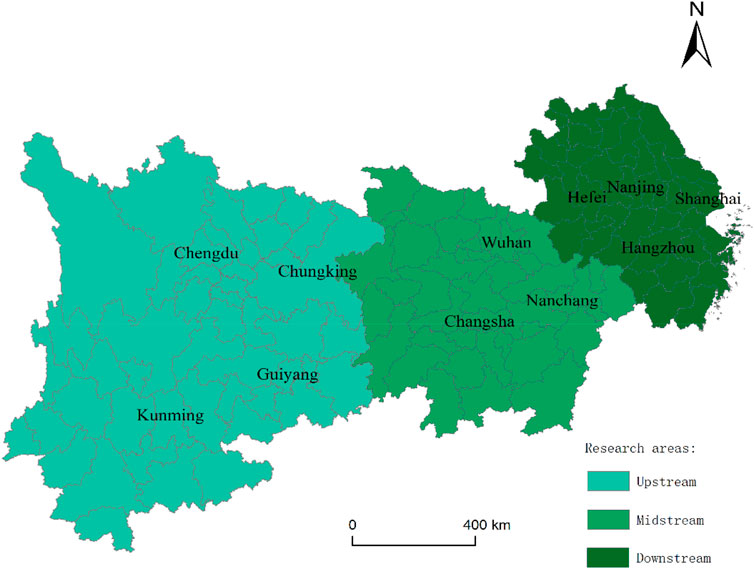
Figure 1. Regional division of the Yangtze River Economic Belt.
The Yangtze River Economic Belt is not only a focal area of urbanization and development but also plays a crucial role in China’s environmental and sustainable growth strategies. With a varied landscape that includes large metropolitan areas, important industrial regions, and diverse ecosystems, research on this area has the potential to yield insights into urban development, economic reform, and environmental policies. In 2022, the Yangtze River Economic Belt had a population of 608 million, representing 43.08% of China’s total population. Of this total, the urban populace amounted to 393 million, constituting 42.73% of the country’s urban inhabitants. The average urbanization rate in the region was 64.92%, marginally surpassing the national average by 0.25%. The importance of the Yangtze River Economic Belt was officially recognized by the State Council in 2014 with the issuance of the “Guiding Opinions of the State Council on Promoting the Development of the Yangtze River Economic Belt by Relying on the Golden Waterway,” elevating the region to a significant national strategic status. The development trajectory was further defined in 2016 when the Political Bureau of the CPC Central Committee approved the Outline for the Development Plan of the Yangtze River Economic Belt, establishing a framework for a national strategy to advance the region’s growth. Moreover, at the 20th National Congress of the Communist Party of China in 2022, General Secretary Xi Jinping underscored the importance of propelling the Yangtze River Economic Belt’s development, with an emphasis on a people-centric approach to urbanization and the promotion of coordinated regional development. The role of the Yangtze River Economic Belt as a principal area of new urbanization in China and a pivotal engine for economic expansion has been a focal point of government policy. According to Fang et al. (2015), the success of urbanization in the Yangtze River Economic Belt is intrinsically tied to the overall success and security of China’s urbanization strategy.
The Yangtze River Economic Belt is a crucial economic development corridor in China, covering 11 provinces and cities, accounting for 21% of the country’s land area, and more than 40% of its population and economic output. The Yangtze River Economic Belt plays a pivotal role in China’s regional development and urbanization process. However, the region exhibits unbalanced internal development, with significant disparities in resource endowments, economic foundations, and urbanization levels among the upper, middle, and lower reaches. Rapid urbanization has led to prominent conflicts between human activities and land resources in the Yangtze River Economic Belt.
Focusing on the Yangtze River Economic Belt allows for a better understanding of the internal spatial heterogeneity and the coupling relationship between population and land urbanization at different development stages. It also helps to analyze the causes of human-land relationship imbalances and provide decision-making references for achieving sustainable regional development. Despite limitations in data availability, the Yangtze River Economic Belt’s representativeness and importance justify its selection as the study area. The findings from this region can provide valuable insights into regional development dynamics in China, and the analytical framework and methods employed can be extended to other regions.
In summary, the Yangtze River Economic Belt is selected as the research area due to its critical role in China’s regional development, its internal spatial heterogeneity, and the prominent human-land conflicts it faces. This study aims to provide targeted references for formulating place-based policies and achieving sustainable regional development by investigating the coupling relationship between population and land urbanization and the causes of human-land relationship imbalances in the Yangtze River Economic Belt.
To elucidate the spatiotemporal dynamics of human-land interactions and the factors influencing them, this study focuses on prefecture-level cities within the Yangtze River Economic Belt to discern the underlying trends. The Belt comprises 130 administrative entities at the prefecture level or higher. However, the absence of essential data in certain localities necessitates sample selection based on data availability. Consequently, this paper examines a subset of 110 prefecture-level cities from the Belt. To ensure the reliability of the data, which is essential for deriving accurate conclusions, the primary sources of data are the “China Statistical Yearbook” and the “China City Statistical Yearbook,” spanning the years 2007–2022. These data are supplemented with data from provincial and municipal statistical yearbooks, as well as statistical bulletins from the respective cities over the same period. In instances of missing data for certain years, interpolation methods are employed to estimate the missing values.
A coupled coordination degree model is developed to investigate the nexus between population and land urbanization within the Yangtze River Economic Belt. The ratio of the urban population to the total population serves as a metric for population urbanization, and the ratio of developed land area to the total territorial extent of the administrative region quantifies the level of land urbanization. The coupling degree between population urbanization and land urbanization is computed using Eq. 1. Subsequently, this metric is integrated with a comprehensive coordination index, calculated with Eq. 2, to determine the overall coupled coordination degree, as outlined in Eq. 3. With the available data, these equations can be precisely formulated.
The coupling degree (C) quantifies the interplay between population urbanization and land urbanization for city “i” during the study periods t1 and t2.
where “Ci” represents the coupling degree for city “i,” “Ui” is the standardized value of the population urbanization index for city “i,” and “Li” is the standardized value of the land urbanization index for city “i”.
The comprehensive coordination index (T) reflects the degree of harmony between population urbanization (U) and land urbanization (L), representing the integrated state of urbanization concerning both demographic and spatial factors.
The coupled coordination degree (D) reflects the overall congruence between the processes of population urbanization and land urbanization. The coupling degree (C) is combined with the comprehensive coordination index (T) to reflect the extent of synchronization between the two facets of urbanization.
In this equation, “a” and “b” denote the weights attributed to population urbanization and land urbanization, respectively, indicating their relative significance in terms of the urbanization dynamic. For the purposes of this analysis, the weights are deemed equivalent and are assigned a value of 0.5, underscoring the equal importance of both population and land urbanization in the city’s urbanization trajectory.
Leveraging insights from prior research (Wang and Wen, 2019), Table 1 delineates the classification of the coupled coordination degree into five distinct categories.
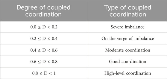
Table 1. Classification Criteria for the coupled coordination degree of population urbanization and land urbanization.
Exploratory spatial data analysis (ESDA) comprises a suite of methods and techniques for analyzing spatial data. These tools are utilized to characterize the spatial distributions of various phenomena, elucidate the distribution characteristics of entities, propose mechanisms of spatial interactions, identify patterns of spatial connectivity, and provide statistical approaches to quantify spatial heterogeneity.
In ESDA, global and local spatial autocorrelation methods are pivotal. This study employs these methods within the ArcGIS 10.8 software environment to capture the spatial heterogeneity and development patterns of the human-land relationships in the Yangtze River Economic Belt. Global spatial autocorrelation methods are used to assess the degree of population–land coordination across a region, and local Moran’s I is frequently applied to determine spatial associations at finer scales. The corresponding formula is as follows:
In the Eq. 4 presented, I denotes the global Moran’s I index. The number of regions being studied is represented by n, and ωij constitutes the spatial weight matrix between regions i and j. The observed values for cities i and j are given by xi and xj, respectively. A positive value of I > 0 signifies the spatial clustering of similar values, indicative of positive spatial autocorrelation. Conversely, a negative value of I < 0 suggests a clustering of dissimilar values, reflecting negative spatial autocorrelation. The index I typically varies between −1 and 1, with values approaching 1 signifying pronounced clustering and those nearing −1 indicating greater dispersion.
The global Moran’s I quantifies the average similarity of features within the study area; however, it does not differentiate between clusters of high-value and low-value features. To account for spatial heterogeneity among the study subjects, the Getis-Ord Gi* statistic is utilized to identify the spatial clusters of features. The Eq. 5 for this calculation is as follows:
This study employs a panel data framework for construction of an analytical model. The canonical form of the panel data model is presented below as Eq. 6:
where yit is the dependent variable and xit is the vector of independent variables for the ith sample at time t, with i ranging from 1 to N and t ranging from 1 to T. The term αit denotes the intercept, k signifies the number of independent variables, βit represents the coefficients to be estimated for the respective independent variables, and μit is the random error component.
By integrating the coupling coordination degree model, exploratory spatial data analysis (ESDA), and panel data model, we gain an in-depth understanding of the spatiotemporal evolution, spatial patterns, and potential driving mechanisms of the coupling coordination between population urbanization and land urbanization in the Yangtze River Economic Belt. The coupling coordination degree model quantifies the synchronization and interaction between the two urbanization processes; ESDA reveals the spatial patterns and clusters of coupling coordination; and the panel data model identifies key influencing factors and their explanatory power.
The integration of these three complementary methods provides a comprehensive framework for analyzing the complex interactions between population urbanization and land urbanization in the Yangtze River Economic Belt. The findings contribute to a better understanding of the coordination between population and land urbanization processes and provide empirical evidence to support sustainable urban planning and policy-making in this region.
Between 2006 and 2021, the Yangtze River Economic Belt experienced changes in both population and land urbanization levels, as well as the degree of coupled coordination, as depicted in Figure 2. A time-series analysis revealed that the urbanization index of the region notably improved during this period. Specifically, the average population urbanization index increased from 0.42 to 0.61, and the average land urbanization index increased slightly from 0.07 to 0.08. The corresponding annual average growth rates were 2.58% for population urbanization and 0.76% for land urbanization. These figures demonstrate more rapid advancement in population urbanization than in land urbanization.
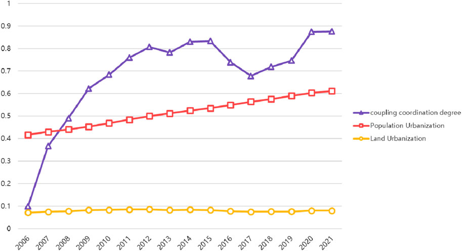
Figure 2. Changes in the coupling degree and coordination degree between population urbanization and land urbanization in the Yangtze River Economic Belt.
In the temporal analysis, there was a consistent enhancement in the coupled coordination level of population and land urbanization within the Yangtze River Economic Belt. The coordination indices for the years 2006, 2011, 2016, and 2021 were 0.1, 0.76, 0.74, and 0.88, respectively, demonstrating a significant upward trajectory, with an average annual growth rate of 15.75%. This indicates a shift from predominantly low-value to high-value areas. A detailed examination of the coupled coordination degree from 2006 to 2021, as shown in Figure 3, revealed a marked decrease in the number of cities experiencing severe imbalance, which plummeted from 72 prefecture-level cities in 2006 to only 3 in 2010 and eventually to none by 2021. Conversely, the number of cities on the brink of imbalance, as well as those achieving moderate and good coordination, initially increased, then decreased, and ultimately stabilized between 2017 and 2021. Cities with high-level coordination significantly increased from none in 2006 to 8 in 2012, surging to 78 by 2021, a trend concurrent with China’s deepening industrialization, increased urbanization, and swift economic structural transformation. In conclusion, the interactive coupled coordination level has demonstrated sustained growth alongside advancements in population and land urbanization.
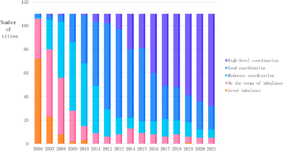
Figure 3. Proportions of coupled coordination types from 2006 to 2021.
With the deepening of industrialization and urbanization in China and the accelerating economic structural transformation, cities that were severely imbalanced in the early stages of development have seen significant improvements. This is highly correlated with a series of policies and institutional reforms implemented by the Chinese government aimed at promoting more balanced and sustainable urbanization, including the “New-Type Urbanization Plan (2014–2020)” and the “Yangtze River Economic Belt Development Plan.” These policies emphasize the coordination of population growth and land development, encouraging local governments to optimize land use planning, improve public service provision, and strengthen environmental protection, thereby promoting the coordination of population and land urbanization.
China’s rapid urbanization process is primarily driven by large-scale rural-urban migration. As migrant workers move to cities in search of better employment opportunities and living conditions, the demand for urban land and housing continues to increase. The formation of urban agglomerations, such as the Yangtze River Delta and the Chengdu-Chongqing urban agglomerations, further promotes the efficient allocation of land resources and the coordination of population growth and land development. Simultaneously, the Yangtze River Economic Belt itself has undergone massive investments in transportation infrastructure, such as high-speed railways and highways, enhancing internal connectivity within the region and reducing transaction costs. This facilitates the flow of population, goods, and information, promoting the integration of urban systems and contributing to the coordinated development of population and land urbanization. Moreover, the development of land markets and the increased role of market mechanisms in land allocation have promoted the coordination of population and land urbanization. Rising urban land prices incentivize local governments and developers to optimize land use, promoting compact and intensive development patterns, thereby improving land use efficiency and better aligning with population growth patterns.
To elucidate the spatial pattern of the coordination of population and land urbanization within the Yangtze River Economic Belt from 2006 to 2021, the years 2006, 2011, 2016, and 2021 were selected as key reference years. Using ArcGIS 10.8 software and referring to the coupled coordination degree classifications in Table 1, spatial distribution maps were constructed for the coordination degree of each prefecture-level city, as depicted in Figure 4.
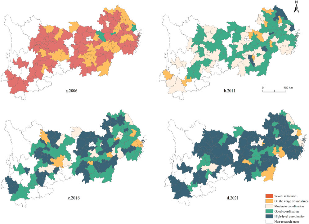
Figure 4. Spatial differentiation pattern of the coupled coordination degree between population urbanization and land urbanization.
Spatial analysis revealed a year-over-year increase in the coupled coordination degree among prefecture-level cities within the Yangtze River Economic Belt.
The areas characterized by good and high-level coordination predominantly lie in the middle and lower reaches of the Yangtze River Economic Belt, encompassing Shanghai, Zhejiang, and Jiangsu, as well as certain provincial capitals. These regions boast a robust industrial base and a fruitful employment landscape, fostering tight economic integration and a high capacity to draw rural populations into urban settings. The combination of population concentration and the expansion of urban construction land has accelerated the pace of land urbanization, resulting in a synergistic interplay between population and land dynamics.
Initially, in 2006 and 2011, the regions on the verge of imbalance and those exhibiting moderate coordination comprised approximately half of the study area. However, by 2016 and 2021, such regions were limited to sporadic distributions across several provinces throughout the upper, middle, and lower reaches of the Yangtze River basin.
Over the study period from 2006 to 2022, the highest incidence of severe imbalance occurred in 2006, with 72 cities representing 65.45% of the sample. Since 2011, following the adoption of comprehensive national policies and the recurrent promotion of the Yangtze River Economic Belt as a pivotal national development initiative, no prefecture-level cities within the belt have experienced a severe imbalance in the coupled coordination of population urbanization and land urbanization.
Overall, disparities between regions exhibiting high and low levels of coupled coordination are progressively diminishing. This trend may reflect the efficacy of targeted policy interventions alongside the inherent dynamics of economic advancement, contributing to a more uniform and synchronized urbanization process throughout the Yangtze River Economic Belt.
The global Moran’s I index was employed to assess the spatial clustering tendencies of the degree of coupled coordination between population urbanization and land urbanization, as presented in Table 2. The analysis revealed that from 2006 to 2010, there was a progressive intensification of spatial autocorrelation in the coupled coordination degree, with Moran’s I increasing from 0.14 in 2006 to 0.339 in 2010. This trend was followed by a consistent decline post-2011. The temporal pattern of the global Moran’s I index during the study period exhibited a fluctuating trend, and the p-value was statistically significant at the 5% level, indicating a consistent normal distribution. A positive value of the global Moran’s I index, greater than zero, confirms a significant positive spatial correlation, implying that the coupled coordination degree of a given city is not only influenced by but also influences that of neighboring cities.
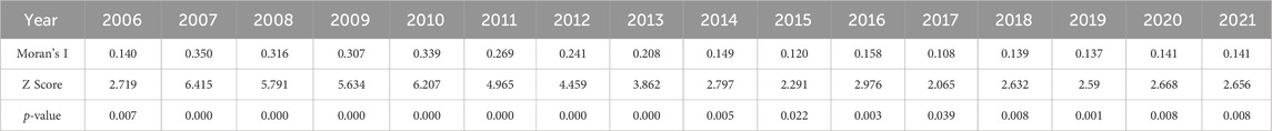
Table 2. Global Moran’s I index and test results of the coupled coordination degree of cities in the Yangtze River economic belt.
A detailed examination of the local spatial heterogeneity in the coupled coordination degree of population and land urbanization within the Yangtze River Economic Belt was conducted. The Getis-Ord Gi* index was calculated for the constituent cities for 2006, 2011, 2016, and 2021. By applying the natural breaks (Jenks) classification method, the indices were organized in ascending order into categories of cold spots, subcold spots, areas with a random distribution, subhot spots, and hot spots. This classification facilitated the development of spatial distribution maps depicting these hot spots and cold spots, as illustrated in Figure 5.
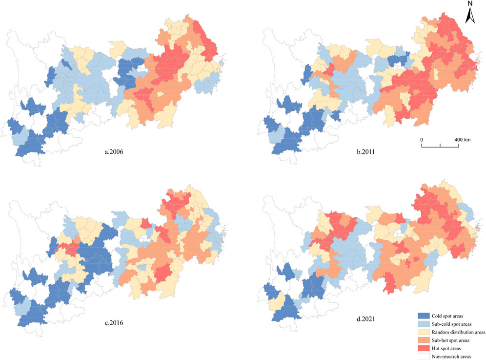
Figure 5. Spatial distribution of cold and hot spots of the coupled coordination degree between population urbanization and land urbanization in the Yangtze River Economic Belt.
The analysis revealed a consistent spatial transition from hot spots to cold spots across the east‒west axis of the Yangtze River Economic Belt for the years 2006, 2011, 2016, and 2021, with pronounced spatial differences in the degree of coupled coordination between population and land urbanization. Initially, in 2006, hot spots and subhot spots were predominantly located in the central and lower reaches of the Belt, encompassing specific cities. Over time, cities such as Xiangyang, Yichang, Jingmen, Jingzhou, and Suizhou in Hubei Province and the majority of cities in Sichuan Province emerged as hot spots and subhot spots. Conversely, cold spots and subcold spots were mainly situated in the upper reaches, particularly in most cities of Yunnan Province, as well as Anshun, Zunyi, and Tongren in Guizhou Province and Ya’an in Sichuan Province. Chongqing consistently ranked as a cold or subcold zone, while certain cities in Sichuan and Guizhou exhibited a trend of evolving from subcold spots to hot or subhot spots. This dynamic culminated in a spatial distribution pattern typified by prominent hotspots juxtaposed with smaller cold spots.
The enhanced coordination between demographic and land urbanization manifests in urban planning and management through several key aspects. Firstly, urban planners can leverage the increased coordination to develop more integrated land use and transportation plans, strategically locating residential areas, employment centers, and public amenities along transit corridors. This optimizes the spatial distribution of urban functions, reduces commuting times and traffic congestion, and promotes compact and efficient urban forms. Secondly, the enhanced coordination allows urban managers to better align the provision of infrastructure and public services with the changing demographic and spatial patterns of urbanization. By anticipating and responding to the evolving needs of urban residents, managers can ensure the timely and efficient delivery of essential services, improving the quality of life in cities. Thirdly, the shift towards greater coordination necessitates more collaborative and participatory planning processes that engage diverse stakeholders. Urban planners can facilitate multi-stakeholder dialogues and partnerships to co-create and implement shared visions for sustainable urban development, fostering a sense of ownership and social cohesion.
Drawing upon the studies of Zhang et al. (2019) and Zhang and Duan (2021) and Chen and Yu. (2023) and considering data accessibility, critical variables such as economic development level, fixed asset investment, educational expenditure, and governmental actions were identified as determinants of the coupled coordination degree of population and land urbanization in the Yangtze River Economic Belt (refer to Table 3). To neutralize the effect of differing units of measurement, all variables were converted into logarithmic form. The rationale for selecting these variables was based on the following premises.
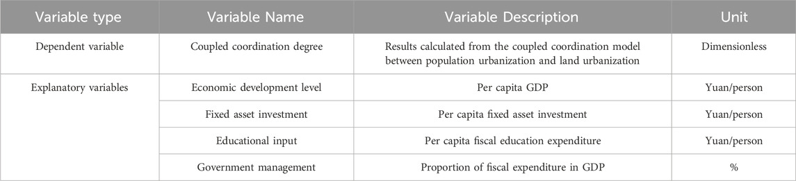
Table 3. Factors influencing the coupled coordination degree.
The level of economic development constitutes the foundation of urbanization. As it advances, the expansion of cities accelerates, fostering land development and utilization. Concurrently, this growth engenders an increase in employment opportunities and remuneration, thereby stimulating population urbanization, as indicated by per capita GDP. As an indicator of economic development, higher per capita GDP implies better job opportunities, infrastructure, and public services in urban areas, which can attract more population inflow and promote population urbanization. Meanwhile, economic growth also stimulates the demand for urban land expansion, driving land urbanization.
Investment in fixed assets bolsters urban infrastructure, propels the expansion of urban construction land, and refines the configuration of urban functional zones. Its integral role in urbanization is captured by the per capita fixed-asset investment indicator. Increased investment in fixed assets, such as infrastructure and real estate, directly contributes to land urbanization by expanding the built-up area. It also indirectly promotes population urbanization by improving urban living conditions and attracting population inflow.
Educational investment supplies the human capital essential for urban development, catalyzing the concentration of innovative forces in urban areas. By enhancing the populace’s educational quality and propelling technological progress, this type of investment bridges the urban‒rural divide and is quantified by per capita fiscal educational spending. Higher education expenditure indicates better educational resources and human capital development in urban areas, which can attract more population inflow and enhance the quality of urbanization. This factor mainly influences population urbanization.
Governmental action is pivotal in urbanization, with active policy direction shaping the resource distribution across urban centers. The efficacy of local governmental management markedly influences this process, as reflected by the share of local fiscal spending in GDP. A higher ratio of this factor suggests a stronger role of the government in urban development. Government expenditure on public services, infrastructure, and urban planning can guide and regulate the processes of population urbanization and land urbanization, promoting their coordinated development.
However, these four influencing factors exhibit an interrelated and mutually reinforcing relationship. Firstly, the level of economic development, as measured by per capita GDP, is closely linked to fixed asset investment. Economic growth can stimulate investment in infrastructure and real estate, which in turn supports further economic development, creating a virtuous cycle. Secondly, fiscal education expenditure and local fiscal expenditure are both tied to government policies and budget allocation. They respectively reflect the government’s priorities in terms of human capital development and urban development. Lastly, economic development and government expenditure are also interconnected. Government investment in public services and infrastructure can create a conducive environment for economic growth, while economic growth can generate more fiscal resources to support government expenditure.
When investigating the impact of factors such as economic development level, fixed asset investment, educational input, and government management on the coupling coordination degree of population and land urbanization, endogeneity issues may affect the reliability of the results. Endogeneity problems mainly stem from two aspects: omitted variables and measurement errors. First, the model may omit some important variables that simultaneously influence the coupling coordination degree of population and land urbanization and the explanatory variables in the model, leading to the correlation between explanatory variables and the error term. For instance, factors such as the geographical location and resource endowment of a city may concurrently affect the coupling coordination degree of population and land urbanization and the level of economic development, but these factors are difficult to accurately measure and incorporate into the model. Second, there may be measurement errors in the explanatory variables (e.g., economic development level, fixed asset investment, educational input, and government management), causing the measurement errors to be correlated with other variables, thus leading to endogeneity issues.
To mitigate the endogeneity problems, this study employs a fixed-effects model for analysis. The fixed-effects model introduces individual and time effects, which to a certain extent controls for the omitted variables that do not change over time and individual heterogeneity, thereby alleviating the impact of endogeneity issues. Furthermore, we determine the applicability of the fixed-effects model through the F-test and Hausman test.
The model’s computed outcomes reveal that the R-squared (R2) values for the entire Yangtze River Economic Belt, as well as its upper, middle, and lower reaches, are 0.573, 0.681, 0.528, and 0.562, respectively. These figures indicate that the models possess relatively strong explanatory capabilities (refer to Table 4).
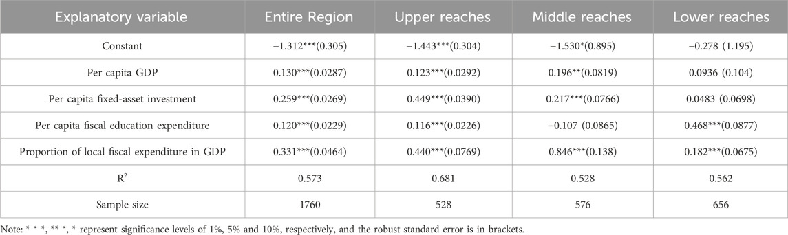
Table 4. Analysis results of factors influencing the coupled coordination degree between population and land urbanization in the Yangtze River Economic Belt.
The regression analysis indicates that government administration is the dominant factor influencing the degree of coupled coordination, exerting a significant positive impact that is statistically significant at the 1% level. Specifically, a 1% increase in the ratio of local fiscal expenditure to GDP results in a 0.331% increase in the degree of coupled coordination. Within the Yangtze River Economic Belt, government management has emerged as the crucial element affecting the degree of coordination. Regional bias in governmental decision-making influences the resource distribution among cities. Following the 2006 national strategy to advance the development of the central region, an economic network centered on the five-way linkage of Wuhan, Yueyang, Changsha, Nanchang, and Jiujiang emerged. In August 2012, the State Council’s “Several Opinions on Vigorously Implementing the Promotion of the Central Region’s Rise” advocated for strategic cooperation among the Wuhan, Changsha-Zhuzhou-Xiangtan, and Poyang Lake city clusters, aiming to foster the integrated evolution of the central Yangtze River’s urban conglomerates. By September 2021, Hubei, Hunan, and Jiangxi provinces launched the “General Concept of Strategic Cooperation in the Middle Reaches of the Yangtze River,” creating a structured promotion mechanism with distinct decision-making, coordination, and execution layers. National and provincial governments have placed considerable emphasis on the growth of central cities along the Yangtze River’s midsection, enhancing the urbanization of both the population and land in this region. The data analysis in Table 3 reveals that the influence of local governments on the degree of coupled coordination is most pronounced in the central region, with the upper reaches following and the lowest impact in the lower reaches. This variation is attributed to the more stringent urban construction land indicators in the lower reaches, where government land development strategies for individual cities differ markedly from those in the central and western regions, with a trend toward fine-scale management.
A comprehensive analysis revealed that fixed asset investment ranks as the second-most-crucial factor following government management, surpassing the 1% significance threshold. An increase of one percentage point in per capita fixed asset investment correlates with a 0.259% increase in the coupled coordination degree. Specifically, the regression coefficients for the upper and middle reaches are 0.449 and 0.217, respectively, both exceeding the 1% significance level. However, the effect in the lower reaches was not statistically significant. These findings underscore the growing influence of fixed-asset investment on population and land urbanization, which is intimately linked to escalating urban construction investments across the Yangtze River Economic Belt. When considering aggregate fixed-asset investment, the sequence is as follows: lower reaches > middle reaches > upper reaches. This suggests that the influence of fixed-asset investment on the coupled coordination degree is characterized by diminishing marginal returns.
The economic development level is a significant determinant of the degree of coupled coordination. Regression analyses indicate that economic development exerts a positive effect on this degree, confirmed by surpassing the 1% significance level. Specifically, a 1% increase in per capita GDP is associated with a 0.13% increase in the degree of coupled coordination. Regionally, the influence of economic development is more pronounced in the middle reaches than in the upper reaches, although it is negligible in the lower reaches. The middle reaches benefit from locational factors such as enhanced openness and a higher capacity for absorbing industrial shifts than that in the lower reaches, fueling industrial structure evolution and deepening the synergy between population and land urbanization. The negligible influence in the lower reaches may stem from the elevated costs of urban residential land, which heighten the expense of rural‒urban migration. This ‘crowding out’ effect is particularly marked in more economically advanced cities, as it impedes labor mobility (Wang et al., 2017).
Overall, the influence of educational investment on the degree of coupled coordination is the least pronounced, manifesting significant effects only in the lower reaches of the Yangtze River Economic Belt. Here, a 1% increase in educational investment corresponds to a 0.468% increase in the degree of coupled coordination. In contrast, such investment yields no substantial impact in the upper reaches and demonstrates no correlation in the middle reaches. This disparity can be attributed to the advanced economy and superior infrastructure in the lower reaches, which have historically attracted substantial talent inflows, whereas the middle and upper reaches have only recently experienced more pronounced talent outflows. Consequently, in the upper reaches, human capital fails to translate into tangible benefits from educational investment, exacerbating the industrial and technological divide between the more developed lower reaches and the upper reaches.
To ensure the robustness of the regression results, this study conducts robustness tests by replacing variables and changing the study period.
Following the approach of Li and Cui (2022), this study replaces GDP per capita with per capita disposable income for robustness testing. The analysis results are presented in Table 5. The test results indicate that the conclusions are consistent with those before the variable substitution, suggesting that the conclusions of this study are robust.
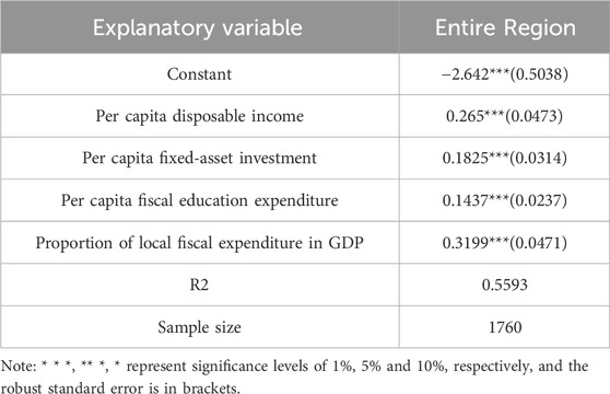
Table 5. Robustness test by variable substitution.
The impact of the coupling coordination degree of population and land urbanization may vary at different stages of development. Taking 2012 as the time dividing point, the period from 2006 to 2012 is considered the first stage of the coupling coordination development of population and land urbanization, while the period from 2013 to 2021 is the second stage (Sun, 2018). The analysis results are presented in Table 6.
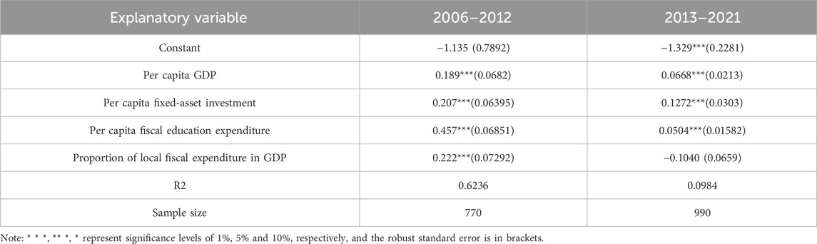
Table 6. Robustness test by changing the study period.
The regression analysis using the fixed-effects model reveals that in the first stage, the development of economic development level, fixed asset investment, educational input, and government management in the Yangtze River Economic Belt still plays a significant positive role in the overall coordinated development of population and land urbanization. In the second stage, economic development level, fixed asset investment, and educational input have a significant positive impact on the coupling coordination degree of population and land urbanization, while the influence of government management loses its significance. This may be due to government policies during this period, such as the “New-type Urbanization Plan (2014–2020)” and the “Yangtze River Economic Belt Development Plan,” which emphasize local autonomy, potentially weakening the role of government management. Moreover, after the 18th National Congress of the Communist Party of China, General Secretary Xi Jinping repeatedly emphasized the need to accelerate the transformation of the economic development model and the implementation of an innovation-driven development strategy. This has led to economic growth in the second stage relying more on the service industry and innovation-driven factors, and less on government-led investment and infrastructure construction, which may diminish the impact of government management on urbanization. The robustness test by changing the study period demonstrates that the conclusions of this study remain robust.
The novelty of this study lies in its focus on 110 prefecture-level cities in the Yangtze River Economic Belt as the research area and its comprehensive and integrative approach to analyzing the coupling coordination between population urbanization and land urbanization in the Yangtze River Economic Belt. Compared to previous studies, we utilize multiple complementary methods, including the coupling coordination degree model, exploratory spatial data analysis (ESDA) techniques, and panel data models, which allow us to reveal the complexity of human-land dynamics from various perspectives. Our study not only uncovers the spatio-temporal patterns and regional disparities of coupling coordination but also identifies the key influencing factors and their relative importance, providing new insights into the driving mechanisms of human-land dynamics in the Yangtze River Economic Belt. The major findings are summarized below.
1. Temporally, the Yangtze River Economic Belt has consistently demonstrated ascending trajectories in population and land urbanization, as well as a concurrent rise in their coupled coordination degree since 2011. The prevalence of severely imbalanced regions was effectively mitigated within the study period. In recent years, the numbers of cities at risk of imbalance, moderately coordinated cities, and well-coordinated cities have stabilized, with an annual increase in highly coordinated cities signaling a shift from low-to high-value coordination areas. Spatially, areas with higher coupled coordination values tend to be clustered in the economically advanced middle and lower reaches of the Yangtze basin, while lower-value areas are predominantly located in the upper reaches. Notably, the disparity in coupled coordination levels across regions is decreasing, exhibiting a distinct pattern of higher values in the east and lower values in the west.
2. The Moran’s I index, applied to assess the spatial correlation of the coupled coordination degree between population and land urbanization within the Yangtze River Economic Belt, displays a wave-like pattern, indicative of spatial clustering tendencies. The coupled coordination hot spots are predominantly located in the middle and lower reaches of the belt region; in contrast, cold spots are observed in the upper reaches, specifically in Yunnan and Guizhou, reflecting a spatial pattern characterized by expansive hot spots and confined cold spots.
3. The synergistic progression of population and land urbanization in the Yangtze River Economic Belt can be attributed to the combined influence of various elements, such as governmental regulation, fixed-asset investment, the level of economic development, and investment in education. Among these factors, governmental management has emerged as the foremost driver, and fixed-asset investment exerts a considerable positive effect on coordination; conversely, economic development status and educational investment exert somewhat lesser impacts on the coupling of population and land urbanization.
The selection of 110 prefecture-level cities in the Yangtze River Economic Belt as the research area allows for a granular and localized analysis of the coupling coordination between population urbanization and land urbanization. This regional perspective complements existing studies that have primarily focused on national or provincial levels, providing a more nuanced understanding of the spatial heterogeneity and local variations in human-land interactions during rapid urbanization and economic development.
The integration of multiple complementary methods, including the coupling coordination degree model, ESDA techniques, and panel data models, strengthens the robustness and comprehensiveness of our analysis. These methods enable us to quantify the synchronization and interaction between population urbanization and land urbanization, uncover spatial patterns and clusters, and identify key influencing factors shaping the coupling coordination.
The findings have significant implications for formulating targeted, place-based policies to promote sustainable urbanization and coordinated regional development in the Yangtze River Economic Belt. By identifying regional disparities, spatial clusters, and key influencing factors, our research provides valuable insights for policymakers and urban planners to address imbalances in human-land dynamics and develop effective strategies tailored to the specific needs and characteristics of different cities and regions.
Moreover, our study highlights the value of adopting a comprehensive and integrative approach to analyze human-land dynamics, serving as a useful reference for future related research. The combination of multiple complementary methods demonstrates the importance of considering the multidimensional nature and spatial heterogeneity of human-land interactions, as well as investigating the underlying driving mechanisms from various perspectives.
The strategic vision for the Yangtze River Economic Belt involves harmonizing human and land development to diminish regional imbalances and foster unified progress. Accordingly, the following recommendations are proposed.
The government should strengthen the top-level design and spatial planning of the Yangtze River Economic Belt, optimizing the spatial distribution of industries based on local resource endowments and comparative advantages. High-polluting and resource-intensive industries should be gradually phased out or upgraded, while eco-friendly and knowledge-intensive industries should be prioritized. The Yangtze River Delta region should focus on developing high-end manufacturing and modern service industries, while the central and western Yangtze River Economic Belt should leverage their ecological advantages to develop green industries such as ecotourism, organic agriculture, and renewable energy. At the same time, policymakers should prioritize the development of compact, mixed-use urban areas that efficiently utilize land resources while providing accessible employment opportunities and public services. This can be achieved by promoting transit-oriented development, encouraging the growth of knowledge-intensive industries, and revitalizing underutilized urban spaces. By optimizing spatial planning and industrial layout, cities can foster more sustainable and inclusive urbanization patterns that align with the coordinated development of population and land.
To address the regional disparities in the human-land relationship, it is crucial to establish effective coordination mechanisms and platforms for cross-regional cooperation. The government should set up a high-level coordination committee for the Yangtze River Economic Belt to harmonize regional development strategies, major policies, and key projects. Regional coordination can help mitigate the negative externalities of rapid urbanization, such as urban sprawl, environmental degradation, and social inequalities. Local governments should establish collaborative mechanisms to address cross-jurisdictional issues, such as regional infrastructure planning, environmental protection, and resource sharing. By fostering regional cooperation, policymakers can promote a more integrated and harmonious development pattern that benefits both urban and rural areas. A regional cooperation fund could be established to support joint projects and facilitate resource sharing among regions. The coordination and cooperation should cover various aspects, including infrastructure connectivity, environmental protection, industrial collaboration, and public service provision.
To incentivize the protection and sustainable use of natural resources, it is essential to establish a well-functioning ecological compensation mechanism in the Yangtze River Economic Belt. The central government should increase transfer payments to the ecologically fragile areas in the upper reaches of the Yangtze River, compensating them for the ecological services they provide. The compensation funds should be used to support ecological restoration, green infrastructure development, and livelihood improvement for local communities. Additionally, green finance instruments such as green bonds, green credit, and environmental taxes should be leveraged to channel more financial resources into eco-friendly industries and projects.
Investing in human capital and technological innovation is key to improving the human-land relationship in the Yangtze River Economic Belt. The government should increase funding for education, vocational training, and research institutions, particularly in the less-developed central and western regions. Policies should be introduced to attract and retain talent, such as providing housing subsidies, research grants, and entrepreneurship support. Universities and research institutes should be encouraged to collaborate with local industries to promote technology transfer and application. Building a robust regional innovation system is crucial for the Yangtze River Economic Belt to achieve sustainable and high-quality development.
Urbanization has been a major driver of the human-land relationship change in the Yangtze River Economic Belt. To promote inclusive and sustainable urbanization, the government should prioritize the development of small and medium-sized cities, as well as the integration of urban and rural areas. More resources should be allocated to improve public services and infrastructure in rural areas, such as healthcare, education, and transportation. The rural land transfer system should be reformed to protect farmers’ land rights while facilitating efficient land use. Moreover, adopting green building standards, promoting sustainable transportation, and preserving urban green spaces can contribute to the creation of livable, low-carbon cities. By fostering inclusive and sustainable urbanization, cities can achieve a more balanced and harmonious development that enhances the wellbeing of both people and the environment.
In conclusion, promoting the coordinated development of the human-land relationship in the Yangtze River Economic Belt requires a holistic and integrated approach that balances economic growth, social equity, and environmental sustainability. The proposed policy recommendations, including optimizing spatial planning, enhancing regional coordination, improving ecological compensation, investing in human capital and innovation, and fostering sustainable urbanization, provide a roadmap for achieving this goal. The successful implementation of these policies calls for concerted efforts from the central government, local authorities, enterprises, and the public. By adopting a more sustainable and inclusive development model, the Yangtze River Economic Belt can become a role model for other regions in China and beyond in terms of harmonizing the human-land relationship and achieving high-quality development.
The coupling relationship between population urbanization and land urbanization is the result of multiple driving factors. This paper adopts analytical methods such as the coupling coordination degree model, exploratory spatial data analysis, and fixed-effects model to analyze the spatiotemporal characteristics and influencing factors of the coordinated development of population urbanization and land urbanization in 110 prefecture-level cities in the Yangtze River Economic Belt. This has important reference significance for optimizing the resource layout of the Yangtze River Economic Belt. Although it can generally reflect the overall spatial pattern and development stage characteristics of population urbanization and land urbanization in the Yangtze River Economic Belt, the coupling relationship between the two is very complex, and the formation and transformation of the coupling state is also subject to the joint action of multiple factors. It should be pointed out that: (1) for the Yangtze River Economic Belt, research on multi-scale and multi-level structures of microscopic subjects is an important direction for future research; (2) the coordinated development level of the Yangtze River Economic Belt shows significant spatial heterogeneity. How to construct differentiated policies for the coordinated development of population urbanization and land urbanization is the direction that needs to be studied next.
The original contributions presented in the study are included in the article/Supplementary material, further inquiries can be directed to the corresponding author.
LZ: Writing–review and editing. YH: Conceptualization, Data curation, Formal Analysis, Investigation, Methodology, Project administration, Resources, Software, Supervision, Validation, Visualization, Writing–original draft, Writing–review and editing.
The author(s) declare that financial support was received for the research, authorship, and/or publication of this article. This study was supported by Science and Technology Project of Jiangxi Education Department (No. GJJ2202223) and Humanities and Social Science Project of Jiangxi Province (No. JJ23225).
The authors declare that the research was conducted in the absence of any commercial or financial relationships that could be construed as a potential conflict of interest.
The reviewer HL declared a past co-authorship with the author to the handling editor.
All claims expressed in this article are solely those of the authors and do not necessarily represent those of their affiliated organizations, or those of the publisher, the editors and the reviewers. Any product that may be evaluated in this article, or claim that may be made by its manufacturer, is not guaranteed or endorsed by the publisher.
Chen, M. X., Lu, D. D., and Zhang, H. (2009). Comprehensive evaluation and the driving factors of China’s urbanization. Acta Geogr. Sin. 64, 387–398. doi:10.11821/xb200904001
Chen, S. J., and Yu, D. Y. (2023). Spatio-temporal coupling characteristics and influencing factors of the man-land relationship in the urbanization process of Yangtze River Delta urban agglomeration. World Reg. Stud.
Chen, X. C., Peng, Y. M., Wang, X. L., Xu, Y., Wang, T., and Pan, Y. (2021). Spatial characteristics and formation mechanism of coordination degree of population and land urbanization in the Yangtze economic belt. Soil Water Conserv. Res. 28, 375–379. doi:10.13869/j.cnki.rswc.2021.05.043
Deng, H. D., Zhang, K. E., Wang, F., and Dang, A. (2021). Compact or disperse evolution patterns and coupling of urban land expansion and population distribution evolution of major cities in China, 1998-2018. Habitat Int. 108 (34), 102324. doi:10.1016/j.habitatint.2021.102324
Deng, Z. B., Zong, S. W., Su, C. W., and Chen, Z. (2019). Study on the coupled and coordinated development of ecological civilization construction and new urbanization in the Yangtze River economic belt and its driving factors. Econ. Geogr. 39, 78–86. doi:10.15957/j.cnki.jjdl.2019.10.011
Fang, C. L., Zhou, C. H., and Wang, Z. B. (2015). Strategic issues and graded gradient development focus of sustainable development of urban agglomerations in the Yangtze economic belt. Prog. Geogr. Sci. 34, 1398–1408. doi:10.18306/dlkxjz.2015.11.007
Feng, W. L., Liu, Y. S., and Qu, L. L. (2019). Effect of land-centered urbanization on rural development: a regional analysis in China. Land Use Policy 2019, 104072. doi:10.1016/j.landusepol.2019.104072
Han, H. L., and Li, H. (2020). Coupling coordination evaluation between population and land urbanization in Ha-Chang urban agglomeration. Sustainability 12, 357. doi:10.3390/su12010357
Huang, L., and Yang, P. (2021). Spatio-temporal characteristics and driving factors of the coordinated development of non-agriculturalization of population-land-industry in the Yangtze River economic belt. China Agric. Resour. Zoning 42, 182–192. doi:10.7621/cjarrp.1005-9121.20210821
Li, X. M., and Cui, L. (2022). Coupling and influencing factors of digital logistics, regional economy and carbon environmental governance: an empirical test based on panel data of 30 provinces in China. China Bus. Mark. 36, 11–22. doi:10.14089/j.cnki.cn11-3664/f.2022.02.002
Li, Z. L., Kuang, W. H., and Zhao, D. D. (2020). Coupling mechanism of population urbanization and land use in the Beijing-Tianjin-Hebei urban agglomeration. Econ. Geogr. 40, 67–75. doi:10.15957/j.cnki.jjdl.2020.08.009
Lin, A. W., and Fan, X. (2015). Analysis of the coordinated development of population urbanization and land urbanization in Hubei Province. Reg. Res. Dev. 34, 14–18.
Liu, H., Deng, H. B., and Li, X. F. (2016). Study on the spatio-temporal differences of the coordinated development of population urbanization and land urbanization in the Yangtze River economic belt. China Popul. Resour. Environ. 26, 160.
Lu, D. D., and Chen, M. X. (2015). Several understandings on the "national new urbanization plan (2014-2020)" compilation background. Acta Geogr. Sin. 70, 179–185. doi:10.11821/dlxb201502001
Lü, T. G., Wu, C. F., Li, H. Y., You, H., and Cai, X. (2016). The coordination and its optimization about population and land of urbanization: a case study of Nanchang city. Sci. Geogr. Sin. 36, 239–246. doi:10.13249/j.cnki.sgs.2016.02.010
Shan, L., Jiang, Y. H., Liu, C. C., Wang, Y. F., Zhang, G. H., and Cui, X. F. (2021). Exploring the multi-dimensional coordination relationship between population urbanization and land urbanization based on the MDCE model: a case study of the Yangtze River Economic Belt, China. PloS one 6, e0253898. doi:10.1371/journal.pone.0253898
Sun, J. W. (2018). On the development and innovation of regional coordinated development strategy in the new era. J. Chin. Acad. Gov., 109–114+151. doi:10.14063/j.cnki.1008-9314.20180808.005
Sun, J. W., Xi, Q. M., and Yi, S. C. (2023) New urbanization and regional coordinated development. Beijing: China Renmin University Press.
Wang, X. F., and Wen, Y. P. (2019). Study on the evolution and coordination of the spatial pattern of population urbanization and land urbanization in Hunan province. J. Nat. Sci. Hunan Norm. Univ. 42, 34–43. doi:10.7612/j.issn.2096-5281.2019.05.005
Wang, X. Y., Yang, X. P., and Zhang, X. M. (2017). Evaluation of urbanization efficiency and its influencing factors based on DEA-Tobit two-step method: from the perspective of coordinated development between population urbanization and land urbanization. Ecol. Econ. 33, 29–34.
Wei, Y., Xiu, C. L., and Sun, P. J. (2013). Analysis of the urbanization driving mechanism in China since the 21st century. Geogr. Res. 32, 1679–1687. doi:10.11821/dlyj201309010
Wen, Y. P., and Wang, X. F. (2019). Study on the coupling and coordination relationship between industrial structure and ecological environment from the perspective of urbanization in the urban agglomeration of the middle reaches of the Yangtze river. J. Cent. China Norm. Univ. 53, 263–271. doi:10.19603/j.cnki.1000-1190.2019.02.015
Wu, Y. F., Liu, Y. S., and Li, Y. R. (2018). Spatio-temporal coupling characteristics and driving mechanisms of population and land urbanization in China. Acta Geogr. Sin. 73, 1865–1879. doi:10.11821/dlxb201810004
Xu, F., Wang, Z. Q., Chi, G. Q., and Zhang, Z. (2020). The impacts of population and agglomeration development on land use intensity: new evidence behind urbanization in China. Land Use Policy 95, 104639. doi:10.1016/j.landusepol.2020.104639
Xu, G., Zheng, M. C., Wang, Y. X., and Li, J. (2022). The urbanization of population and land in China: temporal trend disparities, size, effect and comparisons of measurements. China Land Sci. 36, 80–90. doi:10.11994/zgtdkx.20220513.183256
Yang, L. X., Yuan, S. F., and Wang, X. C. (2013). Study on the spatial differences of the coordinated development of population urbanization and land urbanization: taking 69 counties and cities in Zhejiang province as an example. China Land Sci. 27, 18–22+30. doi:10.13708/j.cnki.cn11-2640.2013.11.004
Yang, Y., Tang, X. L., Jia, Y. Y., and Zhan, Q. Q. (2021). Spatio-temporal coupling and coordination of population-land-economic urbanization in the Yangtze river basin and analysis of driving factors. World Geogr. Res. 30, 978–990. doi:10.3969/j.issn.1004-9479.2021.05.2020120
Yao, S. M., Zhang, Y. H., Lu, D. D., and Yu, C. (2013). Several key issues of China's new urbanization: an interpretation of premier Li Keqiang's new ideas. Urban Obs., 5–13. doi:10.3969/j.issn.1674-7178.2013.05.001
Zhang, L. X., and Duan, W. K. (2021). Urban land urbanization patterns and influencing factors under the background of economic transition: a case study of cities in the Yangtze River economic belt. J. China Agric. Univ. 26, 206–215. doi:10.11841/j.issn.1007-4333.2021.09.22
Zhang, S. L., Zheng, H. Q., Zhou, H. Y., Shao, Q., and Wu, Q. (2021). Sustainable land urbanization, urban amenities, and population urbanization: evidence from city-level data in China. Soc. Sci. Q. 4, 1686–1698. doi:10.1111/ssqu.13003
Keywords: population urbanization, land urbanization, coupled coordination degree, spatiotemporal dynamics, Yangtze River Economic Belt
Citation: Zhou L and Huang Y (2024) Spatiotemporal dynamics and determinants of human-land relationships in urbanization: a Yangtze River Economic Belt case study. Front. Environ. Sci. 12:1412047. doi: 10.3389/fenvs.2024.1412047
Received: 04 April 2024; Accepted: 28 May 2024;
Published: 20 June 2024.
Edited by:
Xiao Ouyang, Hunan University of Finance and Economics, ChinaReviewed by:
Hua Lu, Jiangxi University of Finance and Economics, ChinaCopyright © 2024 Zhou and Huang. This is an open-access article distributed under the terms of the Creative Commons Attribution License (CC BY). The use, distribution or reproduction in other forums is permitted, provided the original author(s) and the copyright owner(s) are credited and that the original publication in this journal is cited, in accordance with accepted academic practice. No use, distribution or reproduction is permitted which does not comply with these terms.
*Correspondence: Yixin Huang,dG9yeS5odWFuZ3l4QGdtYWlsLmNvbQ==
Disclaimer: All claims expressed in this article are solely those of the authors and do not necessarily represent those of their affiliated organizations, or those of the publisher, the editors and the reviewers. Any product that may be evaluated in this article or claim that may be made by its manufacturer is not guaranteed or endorsed by the publisher.
Research integrity at Frontiers
Learn more about the work of our research integrity team to safeguard the quality of each article we publish.