
94% of researchers rate our articles as excellent or good
Learn more about the work of our research integrity team to safeguard the quality of each article we publish.
Find out more
REVIEW article
Front. Environ. Sci., 28 February 2024
Sec. Environmental Informatics and Remote Sensing
Volume 12 - 2024 | https://doi.org/10.3389/fenvs.2024.1236664
 Nagai Shin1,2*
 Taku M. Saitoh2
 Ayumi Kotani3
 Tomoaki Miura1,4
 Hiromi Nakagawa1Chifuyu Katsumata1Hiroshi Morimoto5Hideyuki Onishi6
The relationship between people and the landscape consists of multi-layer components such as the atmosphere, water, living things, nutrients, livelihood, society, and information. To clarify temporal changes in this relationship, previous studies have used conventional approaches based on field work and satellite observation. However, interpretations based on these conventional two approaches are subject to temporal, spatial, representative, and interpretability gaps. In this perspective and review paper, we propose three approaches to bridge these gaps: (1) text mining of historical documents and data (mining for handwritten or printed old documents, books, diaries, field notes, and statistics), (2) video mining (mining for descriptions, interviews, narrations, and background of photos/video), and (3) social sensing (observing real-world events by using digital communication tools such as social networking services, YouTube, and Google Trends). We discuss the utility, limitation, and perspective of each of these proposed approaches by presenting case examples of their application from Northeast Asia. We found that (1) the text mining approach can be useful to remove the temporal, representative, and interpretability gaps but requires immense amounts of time and labor; (2) the video mining approach can be useful to remove the temporal, representative, and interpretability gaps, but uncertainties remain and there are usage limitations with video materials; and (3) the social sensing approach can be useful to reduce the spatial, representative, and interpretability gaps, but it requires careful consideration in terms of data quality and ethical issues. To deepen our understanding of the relationship between people and the landscape during periods of social and climate change on a scale of seasons to centuries from the viewpoint of personal attributes and traits, we conclude that an integrated analysis that combines the conventional approaches such as field work and satellite observation and the proposed approaches should be further developed. Through the development of our proposed integrated analytical approaches, we expect to establish a new transdisciplinary study that integrates anthropology, sociology, informatics, history, and natural sciences.
Societal and climate changes have always influenced and shaped the relationship between people and the landscape (i.e., people’s living space; Ljungqvist et al., 2021). Since humans first migrated from Africa, they have been confronted with a changing relationship with the landscape (e.g., Stewart and Stringer, 2012; Ziegler et al., 2013; Inamura et al., 2022). To maintain a stable and sustainable relationship with the landscape, people adapted their physical traits (e.g., body size), lifestyles (e.g., clothes, food, and tools), and behavior patterns (i.e., culture) to best suit the environment (e.g., Katzmarzyk and Leonard, 1998; Pecl et al., 2017). However, recent rapid economic development, globalization, development of cyber communications, and the climate crisis have resulted in “external” changes (e.g., land cover and land use change caused by deforestation and plantations, water deficits, disasters, and loss of biodiversity) and “internal” changes (e.g., economic differentials, poverty, discrimination, and geopolitical risk) that have an impact on the relationship between people and the landscape (Ramankutty and Foley, 1999; Scheffers et al., 2016; Secretariat of the Convention on Biological Diversity, 2020; Takeuchi et al., 2021; Sekiyama, 2022; Schug et al., 2023). These changes have often resulted in an unstable and unsustainable relationship between people and the landscape, critically affecting people’s lives (e.g., in the Arctic region: Takakura, 2016; Ksenofontov et al., 2017; Anderson et al., 2018; Bogdanova et al., 2021, in arid and semi-arid regions; Kowal et al., 2021; Liang et al., 2021; Amarsanaa et al., 2022).
A landscape can be considered to consist of multiple layers, including the atmosphere (e.g., weather and air quality), water (e.g., floods and water shortages), living things, nutrients (e.g., soil and water quality), livelihood (e.g., cultivation and livestock farming), land cover and land use, and society (e.g., tradition, culture, and faith), where each layer has seasonal and annual changes and is interdependent with other layers. Consider an example that demonstrates spatio-temporal changes in society and climate in a landscape at a 100–10,000-year scale (e.g., deMenocal, 2001; Tange, 2010; Nishino, 2019; Inamura et al., 2022; Ding et al., 2023). First, rapid climate change affects the geographical distribution of plants and their species compositions and then alters the geographical distribution of animals (Matthews et al., 2011; Boit et al., 2016; Pecl et al., 2017; Yasuda, 2017; Nishino, 2019; Zemeng et al., 2020; Chust et al., 2023). This negatively impacts people who depend on hunting and fishing for their livelihood, and they are forced to begin cultivating crops, livestock farming, and building settlements to adapt to the new landscape. As a consequence, the natural environment is converted into human-made land cover and land uses, such as cultivated areas and pastures. The necessity for cooperative works and accumulation of property lead to the emergence of a governing class and the organization of a state (Inamura et al., 2022). People’s lifestyles become more affluent, the population grows, and culture is physically and intellectually developed (Yasuda, 2017; Nishino, 2019; Inamura et al., 2022). However, dramatic landscape changes caused by overuse of the ecosystem can cause detrimental changes to the habitat and climate (Secretariat of the Convention on Biological Diversity, 2020; IPCC, 2021). As a consequence, vulnerability to disasters increases, and people must adapt to and mitigate against climate and environmental changes (European Environment Agency, 2017; Abbass et al., 2022). In this way, the landscape is an intersection between nature and society in a complicated system (Onishi, 2023).
Currently two main approaches are used to understand temporal changes in the relationship between people and the landscape. First, the conventional “field work” approach can be used to determine external and internal spatio-temporal variability in a landscape on a scale of seasons to years. Ethnographical investigation is an example of a method used in the field. For example, Hiroki Takakura identified the relationship between the livelihood (e.g., cattle breeding) of an indigenous people and a pastoral landscape under climate change by performing field work in the Sakha Republic in Siberia (Takakura, 2010; 2012). In this area, a flood plain of the Lena River, horse ranching is conducted in grassland areas and “alas” distributed on top of a riverine terrace, which is a typical feature in the permafrost that consists of lake and grasslands. In addition, hunting, fishing, and picking of berries and mushrooms is done in and around the Taiga forests (Takakura, 2016; Ksenofontov et al., 2017; Fujioka et al., 2020; Takakura et al., 2021). This type of knowledge is extremely useful, particularly in the analysis and interpretation of satellite image data. For example, Onishi (2018) tried to identify the ethnography of the Nanai ethnic group in Primorye, Russia, by comparing the outcomes of in situ interviews with satellite data observed by the U.S. reconnaissance satellite CORONA in 1960s and Japanese earth observing satellite ALOS in 2010s. In particular, he focused on land cover and land use changes between 1960s and 2010s. However, conducting long-term continuous field work is extremely difficult logistically and expensive. Likewise, the interviews can be subject to a bias; that is, the results may not represent the general situation and may have what we call a “representative” gap. In addition, events such as pandemics and military conflicts can impede field work. It is also hard to conduct long-term continuous investigations over a wide area, so this approach may also have what we call “temporal” and “spatial” gaps.
Satellite observation is a second conventional approach. It can detect the spatio-temporal variability of land surface changes in the landscape at a large scale (from local to regional) on a scale of seasons to decades. Recent technological developments have dramatically increased the spatial resolution and temporal frequency of satellite observations (Moon et al., 2021; Wu et al., 2021; Shin et al., 2023a; 2023b; Wang et al., 2023). When a disaster occurs, detailed data on damage caused by landslides, floods, and tsunamis can be obtained with optical sensors and synthetic aperture radar (SAR) onboard satellites (Rao and Lin, 2011; Huyck et al., 2014; Boschetti et al., 2015; Miura and Nagai, 2020; Li et al., 2021). The Landsat satellite series has accumulated a long-term high-quality data record that allows for the mapping of year-to-year variability of deforestation at a spatial resolution of 30 m (Hansen et al., 2013). The advent of optical sensors with high temporal and spatial resolution has made it possible to observe flowering phenology at an almost individual-tree scale in a tropical rainforest where seasonality is not well understood (Miura et al., 2023). In addition, the development of SAR allowed the estimation of the spatio-temporal distribution of ecosystem structures and above-ground biomass (Laurin et al., 2017; Abbas et al., 2020; Najib et al., 2020). By deriving the RGB composite images, vegetation indices, and the leaf area index from spectral data obtained with optical sensors and SAR, researchers can detect the spatio-temporal distribution of land cover and land use, plant phenology (e.g., timing of leaf-flushing and leaf-falling), and above-ground biomass in the landscape (Barbosa et al., 2015; Buitenwerf et al., 2015; Dronova and Taddeo, 2022; Shin et al., 2023b). In addition, researchers have used night-light data obtained by the VIIRS sensor onboard the Suomi NPP satellite to depict the spatio-temporal distribution of economic activities and the recovery from an electrical power outage from a typhoon at a 500-m spatial resolution (Román et al., 2019; Hu and Zhang, 2020; Elvidge et al., 2021).
However, to truly understand these changes, ground-truth data obtained from in situ observations and field work are needed, as well as fundamental knowledge of various fields of study (Shin et al., 2023b). As a matter of course, satellite observations cannot directly detect personal attributes such as gender, age, race, faith, livelihood, and economic conditions that account for the vulnerability and resilience of people in the face of social and climate changes (Ford et al., 2020; Roy et al., 2022). In other words, satellite observations only detect surface changes in the landscape as digitized signals. Even if the accuracy and spatial, temporal, and spectral resolutions of sensors and radars onboard satellites increase, satellite observations will never directly describe the multiple layers that constitute the landscape as we previously described it. In particular, social and economic viewpoints are needed to account for anthropogenic activities. In this sense, the satellite observation approach has an “interpretability” gap. In addition, the history of earth-observing satellites is only 50 years, and older data are subject to higher uncertainties and more noise due to the inaccuracy of earlier sensors and observation systems (Shin et al., 2023b). In this sense, the approach also has a temporal gap.
In this perspective and review paper, to develop our understanding of temporal changes in the relationship between people and the landscape on a scale of seasons to centuries, we propose the following three approaches to bridge the gaps identified in the conventional approaches: (1) text mining of historical documents and data, (2) video mining, and (3) social sensing. We discuss the utility, limitation, uncertainty, and perspective of each of these proposed approaches by presenting examples of the approaches applied to two areas of Northeast Asia (Japan and Eastern Siberia). In these regions, despite abundant records, invaluable knowledge obtained from records has not yet been sufficiently published internationally due to the language barrier, which is discussed later. To resolve this issue, we focus on these regions. In Section 2, we outline each proposed approach, and in Section 3, we evaluate temporal changes in the relationship between people and the landscape by applying the proposed approaches to specific examples. Then, in Section 4, we discuss the effective integration of the two conventional and three proposed approaches, and in Section 5, we offer concluding remarks. The aim of this perspective and review paper is that we discuss how to develop our understanding of temporal changes in the relationship between people and the landscape under societal and climate change in Northeast Asia by applying the integration of the two conventional and three proposed approaches.
With the text mining of historical documents and data approach, we search for records and numerical data that apply to each component layer of the landscape in old handwritten or printed documents, books, and statistics and then extract useful information by analyzing the spatio-temporal variability of the records (Burgdorf et al., 2023). Historical documents and data are part of the so-called “historical dark data” (Easterday et al., 2018; Kelly et al., 2022). In this perspective and review paper, text mining means both the visual inspection of historical documents and data, as well as computer analyses. For example, in Japan, we can access digitized historical documents and converted PDF files of old books, old diaries, field notes, and statistics on the Web sites of museums, universities, research institutes, and the National Diet Library (e.g., Japan Search: https://jpsearch.go.jp/; Digital collection of the National Diet Library: https://dl.ndl.go.jp/en/; video and sound materials at the National Ethnology Museum: https://htq.minpaku.ac.jp/menu/database_eng.html; the record of field work conducted in Africa, Middle East, Asia, and Oceania during the 1960s and 2010s by a team from Kyoto University in Japan: https://fieldnote.archiving.jp/, Yamada, 2015; Shin et al., 2023a). In previous studies, the paleoclimate before the advent of historical metrological observations was estimated by text mining of records related to flowering phenology of cherry (Aono and Kazui, 2008; Aono, 2015; Shin et al., 2022c), and herbaceous peony and rabbit-ear iris (Aono and Nishitani, 2022), harvest (Garnier et al., 2011; Kiss et al., 2011; Možný et al., 2012), weather, and disasters (Zaiki and Mikami, 2013; Zaiki et al., 2014; Hirano et al., 2018; 2022; Chen et al., 2020; Burgdorf et al., 2023). However, historical documents and data also include various kinds of records such as land cover and land use, forests, fisheries, agriculture, livestock farming, business transactions, tax payments, and economic policy (Büntgen et al., 2012; Daux et al., 2012; Brázdil et al., 2016; 2018). Therefore, it is possible to estimate livelihoods and era by analyzing these records. In addition, the records of habitats and phenology of animals and plants provide useful fundamental data to estimate the past environment and climate (Ellwood et al., 2010; Primack and Miller-Rushing, 2012; McClenachan et al., 2015; Beans, 2018; Shin et al., 2024b). Isotope chronologies in tree-ring cellulose can be used to identify the year of important events, which can be useful in bridging the temporal gap (Liu et al., 2017; Nakatsuka et al., 2020; Nakatsuka, 2021). Historical documents and data are, however, superior to these isotope chronologies because they can identify the exact date of the events and offer much more insight into people’s lives at that time.
This approach does have some limitations, however. First, the quantity and quality of records gradually decrease farther back in time (e.g., Central Meteorological Observatory, 1941; Social services department in Tokyo Prefecture, 2004; Nakatsuka, 2021). Current digitized data and converted PDF files represent only part of the existing historical documents, data, books, and statistics (Shin et al., 2022c). This situation is caused by the high labor cost of digitization, limitations imposed by copyright policies and terms of use for data, and technical issues related to digitization of data (i.e., optical character recognition). Therefore, at present, it is not possible to access all historical documents and data, old books, old diaries, field notes, and statistics electronically via the Internet or any other means (i.e., they are not digitized). In addition, most old books, field notes, and statistics are owned or controlled by local libraries and museums or by individuals. These books and data need to be surveyed on site because much of the material has not been digitized (Shin et al., 2024b). The contents of historical documents and data, old books, old diaries, field notes, and statistics depended on the purpose, interests, and societal position of editors and authors. In particular, the contents of private documents such as old diaries and field notes may be considered to be affected by author’s capricious feeling and interests, and variation of experience.
Second, with this approach, we are often confronted with language barriers because historical documents and old books are written in local languages (e.g., Central Meteorological Observatory, 1941; Social services department in Tokyo Prefecture, 2004; Ge et al., 2008; Chen et al., 2020; Shin et al., 2024b). In other words, there are many cases in which English cannot be used (Amano et al., 2016). In addition, even if a researcher can understand each local language, handwritten archaic words still can impose language barriers (Shin et al., 2024b). For this reason, researchers using this approach must understand each local language. They must also visit local libraries and museums to find useful information from historical documents and data by applying their expertise and experience. However, recently published online metadata, such as bibliographies and lists of owners, can help to save labor and provide useful information prior to a detailed literature examination. Supporting computer applications that can aid researchers who lack certain kinds of expertise (e.g., some AI applications can decipher handwritten archaic words) are being developed to help researchers better understand the contents of historical documents (e.g., “miwo: App for AI Kuzushiji Recognition”, Center for Open Data in the Humanities: http://codh.rois.ac.jp/miwo/index.html.en).
In summary, despite requiring immense amounts of time and labor, the text mining of historical documents and data approach allows researchers to obtain various kinds of information for a given period, region, and field of study for a wide range of temporal (from a seasonal to century) and spatial (from a single location to regional) scales. For this reason, the approach is useful in filling in temporal, representative, and interpretability gaps.
The video mining approach can be used to search for descriptions, interviews, narrations, and backgrounds of photos and videos for each component layer of the landscape from photographs, TV programs, and documentary cinema. Video materials are also considered to be historical dark data.
Efforts have been made using photographs to better understand temporal changes in the landscape by comparing past and current landscape conditions (i.e., time-layered photographs; e.g., the “Time-layered photographs project in Muroran OpenPhoto”: https://openphoto.app/c/cfmuroran; Okinaka and Fukuda, 2000; Shimizu, 2008; Maruyama and Michishita, 2011). In some projects (e.g., “Dear photographs”: https://dearphotograph.com/), photos have been used to understand the development of cities, customs, and culture. Photographs taken by folklorists and botanists can be useful because their targets range from urban districts to rural and remote districts. For instance, the Japanese folklorist Tsuneichi Miyamoto (1907–1981) left behind about 100,000 photographs taken during field work in Japan (Tsuneichi Miyamoto database: http://www.towatown.jp/database/; Matsuo, 2004; Miyamoto, 2009a; Miyamoto, 2009b). To compare past and current conditions in photographs, detailed geolocation and timestamp information is required, and Miyamoto supplied this information in his diary and notes (Miyamoto, 2009a; 2009b). An eminent British plant hunter, Ernest Henry “Chinese” Wilson (1876–1930), took photographs of cherry flowering in 1914 at many famous spots in Tokyo (Furui, 2019). Despite being monochrome, his photos show detailed cherry flowering along with attribution information such as the scientific name of the cherry species, geolocation, timestamp, tree height, tree perimeter, and so on. For this reason, we can easily compare these past conditions with current ones (e.g., the timing of cherry flowering) by taking new photographs in the same locations (Furui, 2019).
The contents of TV programs and documentary cinema include various themes such as ethnography, regional customs and folk arts, climate change, nature, disaster, and social problems (Youngs, 1985; Fernández-Bellon and Kane, 2020; Henley, 2020; Shin et al., 2022b; Kotani et al., 2023). They can provide useful information to understand the personal traits of a particular era (e.g., family values, gender roles, and age and racial traits). However, the video mining approach does have limitations. The geolocation and shooting date cannot be identified in many old photos and video material (Shin et al., 2022b), and old video materials may include inappropriate descriptions and contents from the viewpoint of current morals and values. The contents of video materials may also include biases influenced by the creator’s purpose and intent (Kotani et al., 2023).
Despite the uncertainties and usage limitations of video and photo materials, the video mining approach has an advantage that it can be used to minutely examine people’s lives and traits in a landscape over the past 100 years from a daily to century timescale and from a single location to community spatial scale. For this reason, this approach may be considered useful to remove the temporal and interpretability gaps.
With digital communication tools such as social networking services (SNS; e.g., Twitter [now X], Instagram, Facebook, and Flickr), video sharing sites (e.g., YouTube), and statistical tools of search engine services (e.g., Google Trends: https://trends.google.com/; Yandex statistics: https://wordstat.yandex.com/, a popular search engine in Russia; hereinafter, referred to as GT and Yandex, respectively) (Arthur et al., 2018; Wang et al., 2019), we search for people’s interests, emotions, and state of landscape in near and real time. In this paper, we excluded WhatsAPP and Line because their communication contents are not published on the Internet.
In an analysis of Twitter and Facebook data, which mainly consist of text, we can visualize people’s interests by analyzing the frequency of terms and network graphs of morphemes, as well as examine people’s emotional states by analyzing the context (Arthur et al., 2018; Shin et al., 2021; Albahli, 2022; Malik et al., 2022). People’s interests cover various kinds of fields, such as politics, the economy, culture, nature, disaster, and society, and these interests can be considered to represent the relationship between people and the landscape in a given era. Researchers can also refer to the images linked to the main text (Silva et al., 2018).
In an analysis of Instagram and Flickr data, which mainly consist of images, we can examine the spatio-temporal distribution of a wide variety of people’s interests, such as foods, tourism, butterfly migration, flowering phenology, and recreational activities, by referring to the attribute information of the shooting date and geolocation (Stafford et al., 2010; Yoshimura and Hiura, 2017; Song et al., 2020; ElQadi et al., 2021; Fitchett et al., 2022; ElQadi et al., 2023; Shin et al., 2024a). Similarly, in an analysis of YouTube videos and other data, we can study people’s interests and records in a wide range of topics (Michelsen et al., 2016; Dylewski et al., 2017; Lewis and Park, 2018; Sbragaglia et al., 2022; Vins et al., 2022; Herrera et al., 2023; Shin et al., 2024a).
In search engine analyses, researchers can examine temporal changes in people’s interests for a search term and time period by using the “relative search volumes” (RSV) in GT, which are relative values (from 0 to 100) for a given time period, and the “impressions” scores for Yandex, which are absolute values (Stephens-Davidowitz and Varian, 2015; Shin et al., 2022a). Examples of this kind of study include topics such as temporal changes in cherry flowering phenology (Shin et al., 2022d), utilization of berries (Kotani et al., 2021; Shin et al., 2022a), demand for mushrooms (Diaz-Balteiro et al., 2023), appearance of insects (Takada, 2012), the COVID-19 pandemic (Mavragani and Gkillas, 2020; Amusa et al., 2022), and pollens that trigger seasonal allergies (Hall et al., 2020; Iinuma et al., 2020). GT provides search by country and region, whereas Yandex provides impressions scores for a variety of administrative units (continent, country, region, city, and Russian administrative wards). In a GT analysis, we can search by term and topic. In the search by term, GT provides search results for queries in a given language. In contrast, in the search by topic, predefined thematic headings can be selected and ambiguity in search terms can be avoided. In this case, GT provides search results for queries in all languages, including a given language. For more information about GT and Yandex analyses, please see Kotani et al. (2021) and Shin et al. (2022a).
The social sensing approach also has limitations. It excludes people who cannot or will not connect to the Internet. We also cannot identify personal attributes such as age, gender, occupation, and race (Lopez et al., 2019; Shin et al., 2022a). Moreover, there is potential bias with social media users because of the characteristics of country, region, age, and so on. In addition, the contents of Twitter, Facebook, Instagram, Flickr, and YouTube often include falsehoods and ethical issues (i.e., hate claims, and slander and libel against specific individuals or groups) (Al-Rawi et al., 2021; Albahli, 2022; Leahy et al., 2022; Toliyat et al., 2022; Wang et al., 2022). They also are limited and contain uncertainty caused by a lack of clarity in the terms of use for data and copyright, and Twitter, Facebook, and YouTube lack exact geolocation information unlike Instagram and Flickr (Shin et al., 2021; 2024a). GT also includes uncertainty caused by changing analytical specifications, which have changed at least three times (https://trends.google.com/trends/). As a result, as the target period of study goes farther into the past, the quality of the RSV data gradually decreases (Shin et al., 2022d).
Despite these issues, the social sensing approach can be used to examine people’s interests and emotions, and state of landscape over a wide-area scale by studying a tremendous number of samples that could never otherwise be collected by conventional approaches (e.g., interviews or questionnaire surveys). For this reason, this approach is useful to bridge the spatial, representative, and interpretability gaps over a wide range of temporal (from a seasonal to decadal) and spatial (from a single location to regional) scales.
In this section, we present application examples of each proposed approach and discuss the utility, limitation, and perspective of them. We selected the Yamagata Prefecture, located in the northeastern part of Japan, from 17 to 20 centuries, Eastern Siberia in the late 1980s, and Eastern Siberia in the early 2020s as the target landscapes to show the text mining of historical documents and data, video mining, and social sensing approaches, respectively. There are a lot of old documents related to disaster and rice harvest in Japan; drastic societal changes had occurred in Eastern Siberia where many indigenous people live and vulnerability of ecosystem to climate and societal changes is very high; and many indigenous people who have traditional livelihoods still live in the region today. The geographical locations of three case examples are shown in Figure 1.
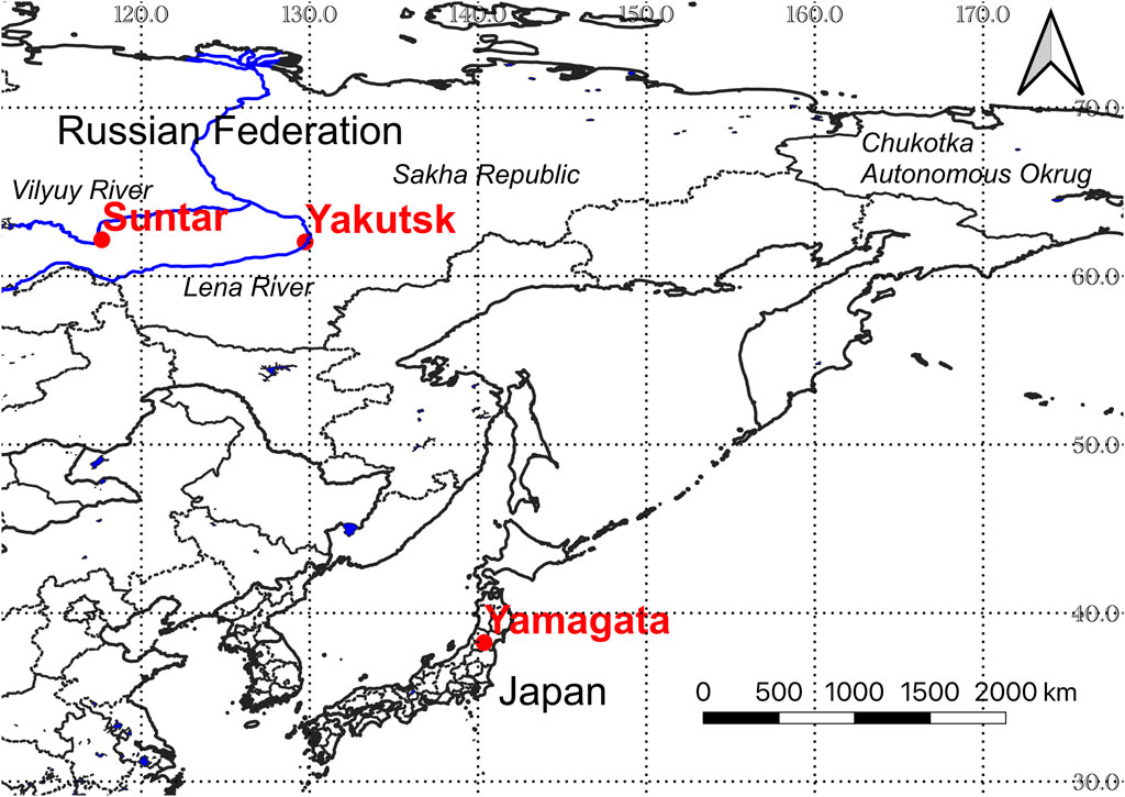
FIGURE 1. Location and region map of Northeast Asia showing case examples of our proposed three approaches. Boundaries, rivers, and lakes are from Natural Earth (http://www.naturalearthdata.com).
We show an example of text mining of historical documents and data for information regarding the relationship between the rice harvest, past disasters, and extreme climate events in Yamagata Prefecture, located in the northeastern part of Japan (Figure 1). We searched for records on these topics from 1,640 to 1,971 in the “Disaster Chronology in Yamagata Prefecture” (Yamagata Local Meteorological Observatory, 1972) and then examined their interrelationships. We were able to access the converted PDF version of the chronology in the Digital Collection of the Japanese National Diet Library (https://dl.ndl.go.jp/en/), but registration was required to access this file. In this chronology, we were able to find past records of disasters, extreme climate events, celestial events, famine, rice harvests, and other information since AD 577. Except for the rice harvest, these records mainly only exist since after establishment of the centralized government (AD 645) in other areas of Japan (e.g., Central Meteorological Observatory, 1941; Social services department in Tokyo Prefecture, 2004). However, literature that recorded annual rice harvest is rare for a long period. We were only able to find two other records of the annual rice harvest in Suwa region in central Japan from 1,690 to 1,960 (Kobayashi, 1962) and in Ishikawa region in central Japan from 1,626 to 1,866 (Ishikawa Agriculture and Forestry Department and Kanazawa weather station, 1961). Therefore, it is generally difficult to accurately evaluate the year-to-year variability of rice harvest.
In Yamagata Prefecture, bad and very bad harvests occurred often before 1850, while moderate, good, and excellent harvests occurred often after 1850 (Figure 2). Specifically, very bad harvests occurred three times during each of the decades 1681–1690, 1741–1750, 1771–1780, 1791–1800, and 1821–1830 and four times during each of the decades 1701–1710 and 1831–1840. In Japan, three great famines occurred in 1732 (Kyoho), 1782–1787 (Tenmei), and 1833–1836 (Tenpo). During these periods, very bad and bad harvests also occurred in Yamagata Prefecture. In contrast, excellent and very excellent harvests occurred four or more times during many decades during the study period (four: 1671–1680 and 1961–1970; five: 1841–1850, 1881–1890, 1901–1910, 1911–1920, 1921–1930, 1931–1940, and 1951–1960; six: 1871–1880).
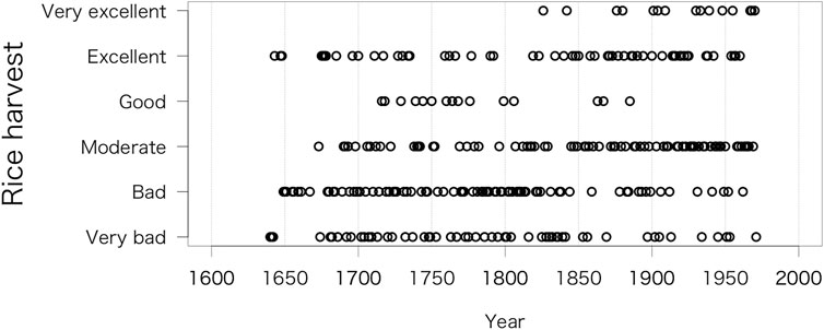
FIGURE 2. Historical records of the rice harvest in Yamagata obtained from “Disaster Chronology in Yamagata Prefecture”.
To identify the factors that account for changes in the rice harvest, we examined the relationship between the rice harvest and past disasters and extreme climate events by using cross tabulations (Figure 3). A statistically significant Cramer’s V coefficient was shown in years with a cold summer (V = 0.23, p < 0.05), little rain and drought during the rainy season (V = 0.25, p < 0.01), heavy rain (V = 0.24, p < 0.001), heavy snow (V = 0.23, p < 0.01), insect damage (V = 0.34, p < 0.001), and a long spell of rain (V = 0.40, p < 0.001). Extremely bad harvests mainly occurred in years with a cold summer, insect damage, and long spells of rain. In contrast, extremely excellent harvests mainly occurred in years with little rain and drought during the rainy season, heavy rain, and heavy snow (Figure 3). Years with a cold summer occurred 12 times more often than those without (odds ratio, p < 0.01). Similarly, compared to years without insect damage, years with insect damage occurred 7 times more often (p < 0.001), and years with a long spell of rain occurred 7 times more often than those without (p < 0.01). These results indicate that the probability of an extremely bad harvest increased during times with low temperatures and long spells of rain during the growing season or in the case of insect damage. Previous studies reported that low temperature during the summer and plant damage due to planthoppers were the main factor related to extremely bad harvests (Yamagata, 1950; Yamagata, 1968; Yamagata Local Meteorological Observatory, 1992; Ikeuchi, 1994; Nakatsuka, 2021).
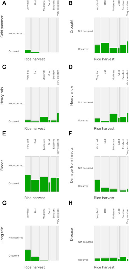
FIGURE 3. Cross tabulations of the rice harvest and the occurrence of typical disasters and extreme climate events from 1,640 to 1,971 ((A): cold summer, (B): drought, (C): heavy rain, (D): heavy snow, (E): floods, (F): damage from insects, (G): long rain, (H): disease). The height and width of each bar is in proportion to the total (i.e., wider and taller are larger).
Despite modern countermeasures against extreme climate events (e.g., maintenance of irrigation facilities and improved rice cultivars), decreased temperature during the growing period of rice plants still causes bad harvests in the Tohoku region, located in the northeastern part of Japan and including Yamagata Prefecture. In fact, a bad harvest occurred in 1993 because of a cold summer (Inoue, 1993). On the other hand, if irrigation facilities are sufficiently maintained, little rain during the growing period of rice plants need not have a negative effect on the growth of rice plants, and the probability of having an excellent rice harvest may be increased. Heavy rains may make up for water shortages, but they have other negative effects such as inundation and runoff from rice field. Heavy snow may also reduce water shortages before the rice-planting season, but it is unlikely to have a direct impact on the growth of rice plants. For these reasons, uncertainty still remains on the effects of heavy rain and snow on the rice harvest.
Despite location limitations in the available data, we were able to understand the relationship between rice growing and climate on a century scale by text mining of past records of disasters, extreme climate events, and rice harvests. We need to further examine the relationship between our results and literature that accounts for social and personal issues in this time period. As a next step to further research in this area, bibliographic survey should be conducted at local libraries and museums through cooperation of local history experts. Records related to work on the rice harvest, famine relief, and annual changes in the amount of rice collected as farm rent from peasants should be useful.
We show an example of the video mining approach applied to the relationship between people and the landscape in Eastern Siberia (Figure 1) in the perestroika era at the end of the 1980s. Here, we concisely summarize the results of Shin et al. (2022b). To this end, we watched 3 documentary TV programs broadcasted on the Japan Broadcasting Corporation (NHK) in 1989. We selected 3 episodes of the documentary “NHK Special: The Arctic Circle” (Arctic-NHK large documentary [volume 2], 1989; Arctic-NHK large documentary [volume 3], 1989). We applied the “NHK archives academic use trial” (https://www.nhk.or.jp/archives/academic/; Miyata and Toriyabe, 2018; Shin et al., 2022b; Kotani et al., 2023) and then watched the TV programs while complying with the usage terms stipulated by this system. Users of this trial are strictly prohibited from copying or photographing any of the TV programs. Requests for captured still images can be made to the secretariat of the trial. For this reason, we took notes on the contents in each program. In the following paragraph, we summarize the characteristics the documentary TV programs (Shin et al., 2022b).
The episode: “The permafrost region in Siberia and exploration of the graveyard of mammoths”, focused on the competition to find mammoth tusks, which were important resources to acquire foreign currencies, among government agency, scientists and local people. Featured locations mainly included the northern part of the Republic of Sakha (formerly the Yakut Autonomous Soviet Socialist Republic), where permafrost covers. The episode: “Pursuit of the last 20 genuine Yukaghir—Arctic ethnic policy of the Soviet Union” focused on the lives of the children of nomadic peoples in Chukotka and Yukaghir hunters under the Soviet planned economy and ethnic polices. Featured locations mainly included Chukotka (now the Chukotka Autonomous Okrug) and the Yukaghir village, where are located in the northern east part of the Republic of Sakha. The episode: “The main artery in Siberia—traveling down the Lena River under the midnight sun” focused on a cruise of the freighter on the Lena River route and the Yakutian people who visited their traditional festival “Osuokhai” grounds. Featured locations mainly included from the upper reaches to the lower reaches of the Lena River, as well as Suntar Village on the Vilyuy River.
Despite the limitations imposed by only having a small number of documentary TV programs, we were able to identify changes in the relationship between people and the landscape in Eastern Siberia during a period of transition from the planned economy of the Soviet Union to the challenge of perestroika by using this approach. As a next step to further research in this area, other documentary TV programs and other video material focused on Eastern Siberia should be viewed to improve our understanding of the relationship between people and the landscape in this area. YouTube videos related to records of the past (e.g., “Old Yaktsk”: https://www.youtube.com/channel/UCjvpc_q6ynA6NPbDD1JOuKQ; Shin et al., 2022b) should be useful.
We show an example of using the social sensing approach in an examination of people’s interests in search terms that include the components of the multiple layers of the Eastern Siberian landscape (Figure 1). We used GT (from May 2018 to May 2023) and Yandex (from March or April 2021 to February or March 2023) to search a total of 320 typical terms categorized into 14 components (animal, ethnicity, famous person, festival, fish, food, island, lake, leisure and sports, mountain, plant, river, tourism, and weather) in Russian. These terms were selected by referring to the Web sites (e.g., http://www.sentstory.ru/yakutiya/[in Russia]) and literature (e.g., Borisova et al., 2017; Ignatieva, 2019; Andrianova, 2021). For GT, we searched for target terms by topic if possible. We then visually inspected the seasonality of time-series in RSV values for GT and in impressions scores for Yandex. For searching with GT, we set the target region of search terms to Russia. With Yandex, the results include all of Russia and some other countries. We examined whether each search term (categorized into 14 components) showed seasonality or not by using cross tabulations (Figure 4). For many components, the ratio of the search terms with seasonality to the total for Yandex was higher than that for GT. The components categorized as festival, fish, island, and plant had the highest ratios. These results indicate that the seasonality of Russian people’s interests is reflected in phenology, traditional events, and weather.
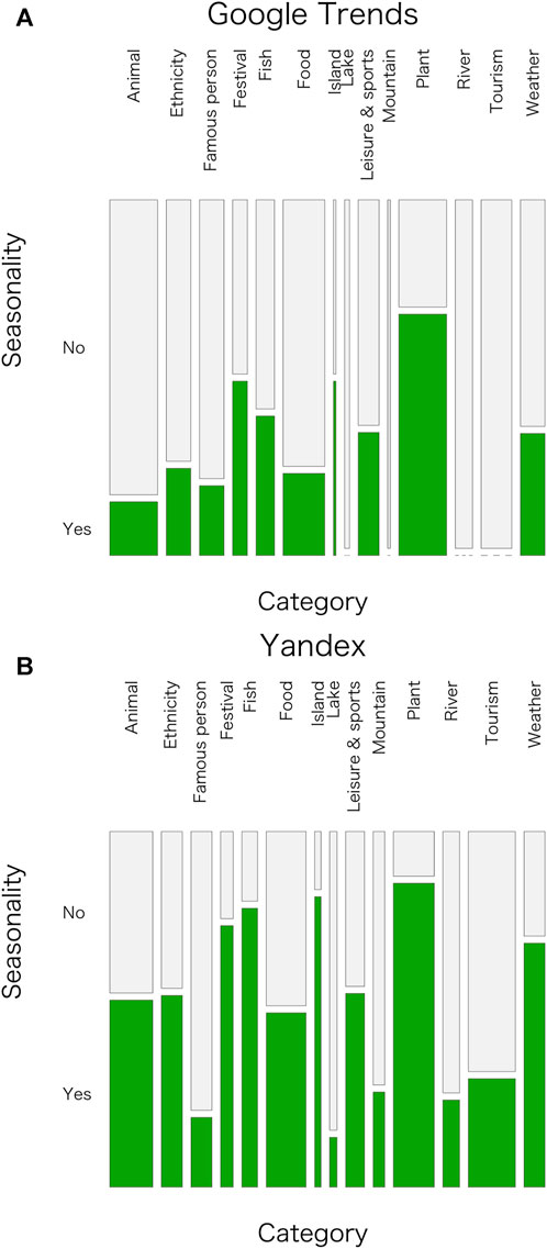
FIGURE 4. Cross tabulations of the seasonality of (A) RSV values for GT and (B) impressions scores for Yandex for 320 typical search terms in the Eastern Siberian landscape, which were categorized as 14 components. The height and width of each bar is in proportion to the total (i.e., wider and taller are larger).
Despite the limitations related to the use of search terms, we were able to identify characteristics of the seasonality of people’s interests in various components of the Siberian landscape by using GT and Yandex. Useful additional research would include a detailed examination of the relationship between our results and the seasonality of people’s interests on other social media, such as Twitter and Instagram. YouTube videos related to tourism, cooking, delicious food, fishing, and gardening, and online market sites should be useful. As a next step to further research in this area, deepening our understanding of the characteristics of traditional culture and manners for each indigenous group, and their integration into the current Russian culture and manners.
In this section, we discuss effectively connecting the two conventional approaches and three proposed approaches to fill in the temporal, spatial, representative, and interpretability gaps. In addition, we discuss the next challenge based on this effective connection. The relationship among these gaps in the two conventional approaches by integrating the three proposed approaches is summarized in Figure 5. Here, we also discuss how to select the appropriate integrated analysis to minimize each gap according to the specific purpose.
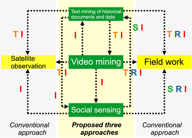
FIGURE 5. Relationship among removable gaps in the two conventional (field work and satellite observation) approaches by integrating three proposed (text mining of historical documents and data, video mining, and social sensing) approaches. T: temporal, S: spatial, R: representative, and I: interpretability gaps.
The text mining of historical documents and data and video mining approaches may be considered to have the following four advantages. First, these two approaches can provide detailed data about the historical background of society and nature in a target landscape, as well as on temporal changes, which improves our understanding based on the field work approach alone (Shin et al., 2022b; Kotani et al., 2023). These two approaches, therefore, contribute to reducing temporal, representative, and interpretability gaps in our understanding based on the field work approach. Second, text mining of historical documents and data and video mining provide data about land cover and land use change before the satellite era (i.e., before 1972; e.g., Debussche et al., 1999; Yang et al., 2014). In addition, they can provide physical parameters that cannot be detected by satellite observations because of insufficient spatial and spectral resolution of optical sensors and radar. They can provide ground-truth data, which are utilized for validation and eco-physiological and hydrological interpretations of satellite data. In this way, these two approaches play a role in the removal of the temporal and interpretability gaps. Third, these two approaches provide detailed data about people’s interests in tradition, culture, and custom that can be used to enhance interpretations based on social sensing data alone and thereby reduce the interpretability gap. To select an analysis target by social sensing, researchers first require fundamental background knowledge of traditions, culture, customs, and society. This knowledge can be obtained via text mining of historical documents and data and video mining (Kotani et al., 2023; Shin et al., 2024b). Forth, these two approaches complement each other. Text mining of historical documents and data provides detailed data about changes related to climate, livelihood, and society for a target area that can be used to reduce temporal and interpretability gaps in our understanding based on the video mining approach alone. Similarly, video mining provides detailed evidence about personal traits in a given area and time period (Kato et al., 2018; Kotani et al., 2023), which can reduce the interpretability gap in our understanding based on text mining alone.
The social approach may be considered to have the following three advantages. First, this approach provides data related to people’s interests and emotions based on a huge number of samples from the Internet (Wood et al., 2013; Tenkanen et al., 2017; Toivonen et al., 2019; Fernández-Bellon and Kane, 2020; Khan et al., 2022). With its large base of data, it can help reduce the spatial and representative gaps in our understanding based on field work alone. The use of such digital data is also getting incorporated into fieldworks in ethnography and geography studies (e.g., Beneito-Montagut et al., 2017; Airoldi, 2018). However, as previously noted, the social sensing approach cannot directly evaluate detailed information related to personal attributes. For this reason, results obtained using this approach may include uncertainties if people’s interests and emotions are affected by certain personal characteristics. However, given the almost ubiquitous nature of smartphones and the Internet in the modern world, the analysis of human communication in cyberspace is a useful approach to remove the interpretability gap in our understanding based on field work alone. Second, this approach provides data on the spatio-temporal distribution of phenology (Kotani et al., 2021; Shin et al., 2022a; 2022d; Fitchett et al., 2022), which can be estimated from the seasonality of people’s interests in foods, events, and recreation (i.e., cultural ecosystem services), as well as ground-truth data for disasters (e.g., Fohringer et al., 2015; Khan et al., 2022) to enhance our understanding based on satellite observations. The potential of spatial analysis utilizing social sensing data is found in, for example, detecting landscape value (van Zanten et al., 2016) and users’ mobility patterns in urban (Soliman et al., 2017). As a consequence, this approach contributes to reducing interpretability gap in our understanding based on the satellite observation approach alone (Soliman et al., 2017). A typical example of this type of use is the spatio-temporal distribution of people’s interests in cherry flowering and leaf coloring in Japan (ElQadi et al., 2021; Shin et al., 2021; 2022c; ElQadi et al., 2023). Third, despite limitations on the period of analysis (e.g., only the past several years), this approach provides an immense amount of data about people’s interests in tradition, culture, and customs, as well as temporal changes in these interests. This kind of information can augment that obtained by text mining and video mining to remove spatial and interpretability gaps in our understanding based those approaches alone.
What kind of breakthrough will it bring by the effective connection between the two conventional approaches and three proposed approaches? We believe that it should allow us to deeply understand the process of people’s adaptation and mitigation to societal, climate and environmental changes from an internal and external viewpoint. Let us take, as an example, a recent huge earthquake (magnitude 7.6) and tsunami event (maximum run-up height 5.8 m at Joetsu City in Niigata Prefecture) that occurred in the Noto region, located in the central part of Japan, on 1 January 2024 (https://www.jma.go.jp/jma/en/2024_Noto_Peninsula_Earthquake/index.html; https://www.jma.go.jp/jma/press/2401/26a/20240126_tsunamichousakekka.pdf). The coastline in the northern part of the Noto Peninsula (faced to Japan Sea) has receded by about 250 m at maximum due to bumps of the seabed (eastern part of Kaiso Port; https://www.eri.u-tokyo.ac.jp/en/news/5994/). The landscape in the Noto region is referred to as a sustainable Satoyama and Satoumi landscape, is very famous, and is recognized as the world agricultural heritage site (https://www.fao.org/giahs/giahsaroundtheworld/designated-sites/asia-and-the-pacific/notos-satoyama-and-satoumi/en/; Hashimoto et al., 2015). Until now, Japanese people and landscape have periodically been impacted and damaged by disasters such as huge earthquakes, tsunami, and floods since time immemorial. After each disaster event, people overcame and reconstructed their livelihood and society. However, the Noto region has a small, aging population (about 0.34 million with the high rate of aging of 34.6% as of 2015; https://www.pref.ishikawa.lg.jp/shinkou/hantou/index.html, in Japanese). Although fishery and agriculture have been people’s livelihood, culture, and local society in this region on a scale of centuries to millenniums, there are concerns that the reconstruction plan as same as conventional one may not be applied to the Noto region because of local characteristics of social background and directionally of decision making. To deeply understand the past adaptation to societal, climate and environmental change in the Noto region and to implement future adaptation planning, the effective connection between the two conventional approaches and three proposed approaches should be useful.
To remove the temporal, spatial, representative, and interpretability gaps in the conventional two approaches, field work and satellite observations, in the studies on relationship between people and the landscape, we proposed additional three approaches: text mining of historical documents and data (mining for handwritten or printed old documents, books, diaries, field notes, and statistics), video mining (mining for descriptions, interviews, narrations, and background of photos/video), and social sensing (observing real-world events by using digital communication tools such as social networking services, YouTube, and Google Trends). Despite limitation due to labor-intensive work, uncertainties, and data policy, text mining of historical documents and data, and video approaches can be useful to remove the temporal, representative, and interpretability gaps. Despite requirement of careful consideration in terms of data quality and ethical issues, the social sensing approach can be useful to reduce the spatial, representative, and interpretability gaps. Integrated analyses including the field work, satellite observation, and our proposed three approaches can deepen our understanding of the relationship between people and the landscape on a scale of seasons to centuries, particularly in times of social and climate change. To predict the future relationship between people and the landscape will require an evaluation of vulnerability and resilience against social and climate change while simultaneously considering the historical, cultural, and social background of any given area or time period. A new transdisciplinary study that integrates anthropology, sociology, informatics, history, and natural sciences will be established by the development of our proposed integrated analytical approaches.
NS designed this study. NS, AK, HN, and CK collected and analyzed the data. NS wrote the manuscript. All authors contributed to the article and approved the submitted version.
This research was supported by KAKENHI grants (JP21H05178 and JP22H04457) from the Japan Society for the Promotion of Science. The study in Section 3.2 was conducted with the NHK archives academic use trial in the second half of 2021 (research assignment: Mining information about people’s lives and the landscape in Eastern Siberia in the 1980s by rescuing past videos).
We thank the editors and four reviewers for their constructive comments. We would like to express our sympathies to those affected by the disaster on the Noto region and to pray for reconstruction.
The authors declare that the research was conducted in the absence of any commercial or financial relationships that could be construed as a potential conflict of interest.
All claims expressed in this article are solely those of the authors and do not necessarily represent those of their affiliated organizations, or those of the publisher, the editors and the reviewers. Any product that may be evaluated in this article, or claim that may be made by its manufacturer, is not guaranteed or endorsed by the publisher.
Abbas, S., Wong, M. S., Wu, J., Shahzad, N., and Irteza, S. M. (2020). Approaches of satellite remote sensing for the assessment of above-ground biomass across tropical forests: pan-tropical to national scales. Remote Sens. 12, 3351. doi:10.3390/rs12203351
Abbass, K., Qasim, M. Z., Song, H., Murshed, M., and Younis, I. (2022). A review of the global climate change impacts, adaptation, and sustainable mitigation measures. Environ. Sci. Pollut. Res. 29, 42539–42559. doi:10.1007/s11356-022-19718-6
Airoldi, M. (2018). Ethnography and the digital fields of social media. Int. J. Soc. Res. Methodol. 21 (6), 661–673. doi:10.1080/13645579.2018.1465622
Albahli, S. (2022). Twitter sentiment analysis: an Arabic text mining approach based on COVID-19. Front. Public Health 10, 966779. doi:10.3389/fpubh.2022.966779
Al-Rawi, A., OʼKeefe, D., Kane, O., and Bizimana, A.-J. (2021). Twitter’s fake news discourses around climate change and global warming. Front. Commun. 6, 729818. doi:10.3389/fcomm.2021.729818
Amano, T., GonzálezVaro, J. P., and Sutherland, W. J. (2016). Languages are still a major barrier to global science. PLoS Biol. 14 (12), e2000933. doi:10.1371/journal.pbio.2000933
Amarsanaa, S., Lkhagva, A., Chogsom, B., Bayaraa, B., Damdin, B., Tsooj, B., et al. (2022). Quantifying the spatial extent of roads and their effects on the vegetation in Mongolia’s Gobi Desert. Land 11, 820. doi:10.3390/land11060820
Amusa, L. B., Twinomurinzi, H., and Okonkwo, C. W. (2022). Modeling COVID-19 incidence with google trends. Front. Res. Metr. Anal. 7, 1003972. doi:10.3389/frma.2022.1003972
Anderson, D., Ford, J. D., and Way, R. G. (2018). The impacts of climate and social changes on cloudberry (bakeapple) picking: a case study from Southeastern Labrador. Hum. Ecol. 46, 849–863. doi:10.1007/s10745-018-0038-3
Andrianova, N. (2021). “Russia’s largest river and coastal city,”in Exciting travelogue from volga river to amur river. Moscow, Russia: Eksmo Publishing House, 176pp. (in Russian).
Aono, Y. (2015). Cherry blossom phenological data since the seventeenth century for Edo (Tokyo), Japan, and their application to estimation of March temperatures. Int. J. Biometeorol. 59, 427–434. doi:10.1007/s00484-014-0854-0
Aono, Y., and Kazui, K. (2008). Phenological data series of cherry tree flowering in Kyoto, Japan, and its application to reconstruction of springtime temperatures since the 9th century. Int. J. Climatol. 28, 905–914. doi:10.1002/joc.1594
Aono, Y., and Nishitani, A. (2022). Reconstruction of April temperatures in Kyoto, Japan, since the fifteenth century using the floral phenology of herbaceous peony and rabbit-ear iris. Int. J. Biometeorol. 66, 883–893. doi:10.1007/s00484-022-02245-x
Arctic-NHK large documentary (volume 2) (1989). “The coldest town in the world –Minus 70 degrees Celsius and Going down the Colyma Highway” and “Permafrost region in Siberia and exploration of graveyard of mammoths”. Tokyo, Japan: NHK Publishing, Inc., 191pp. (in Japanese).
Arctic-NHK large documentary (volume 3) (1989). “Pursuit the last 20 genuine Yukaghir– Arctic ethnic policy of the Soviet Union” and “The main artery in Siberia – downing Lena River under the midnight sun”. Tokyo, Japan: NHK Publishing, Inc., 191pp. (in Japanese).
Arthur, R., Boulton, C. A., Shotton, H., and Williams, H. T. P. (2018). Social sensing of floods in the UK. PLoS ONE 13 (1), e0189327. doi:10.1371/journal.pone.0189327
Barbosa, C. C. d. A., Atkinson, P. M., and Dearing, J. A. (2015). Remote sensing of ecosystem services: a systematic review. Ecol. Indic. 52, 430–443. doi:10.1016/j.ecolind.2015.01.007
Beans, C. (2018). Journal entries, maps, and photos help ecologists reconstruct ecosystems of the past. Proc. Natl. Acad. Sci. U. S. A. 115 (52), 13138–13141. doi:10.1073/pnas.1819526115
Beneito-Montagut, R., Begueria, A., and Cassián, N. (2017). Doing digital team ethnography: being there together and digital social data. Qual. Res. 17 (6), 664–682. doi:10.1177/1468794117724500
Bogdanova, E., Andronov, S., Soromotin, A., Detter, G., Sizov, O., Hossain, K., et al. (2021). The impact of climate change on the food (in)security of the Siberian indigenous peoples in the Arctic: environmental and health risks. Sustainability 13, 2561. doi:10.3390/su13052561
Boit, A., Sakschewski, B., Boysen, L., Cano-Crespo, A., Clement, J., Garcia-alaniz, N., et al. (2016). Large-scale impact of climate change vs. land-use change on future biome shifts in Latin America. Glob. Change Biol. 22, 3689–3701. doi:10.1111/gcb.13355
Borisova, I. Z., Illarionov, V. V., and Illarionova, T. V. (2017). Cultural heritage in the food traditions of the Sakha people. J. Fundam. Appl. Sci. 9 (2S), 1388. doi:10.4314/jfas.v9i2s.850
Boschetti, M., Nelson, A., Nutini, F., Manfron, G., Busetto, L., Barbieri, M., et al. (2015). Rapid assessment of crop status: an application of MODIS and SAR data to rice areas in Leyte, Philippines affected by typhoon Haiyan. Remote Sens. 7, 6535–6557. doi:10.3390/rs70606535
Brázdil, R., Chromá, K., Valášek, H., Dolák, L., and Řezníčková, L. (2016). Damaging hailstorms in South Moravia, Czech Republic, in the seventeenth to twentieth centuries as derived from taxation records. Theor. Appl. Climatol. 123 (1–2), 185–198. doi:10.1007/s00704-014-1338-1
Brázdil, R., Kiss, A., Luterbacher, J., Nash, D. J., and Řezníčková, L. (2018). Documentary data and the study of past droughts: a global state of the art. Clim. Past. 14, 1915–1960. doi:10.5194/cp-14-1915-2018
Buitenwerf, R., Rose, L., and Higgins, S. I. (2015). Three decades of multi-dimensional change in global leaf phenology. Nat. Clim. Change 5, 364–368. doi:10.1038/NCLIMATE2533
Büntgen, U., Ginzler, C., Esper, J., Tegel, W., and McMichael, J. (2012). Digitizing historical plague. Clin. Infect. Dis. 55 (11), 1586–1588. doi:10.1093/cid/cis723
Burgdorf, A.-M., Brönnimann, S., Adamson, G., Amano, T., Aono, Y., Barriopedro, D., et al. (2023). DOCU-CLIM: a global documentary climate dataset for climate reconstructions. Sci. Data 10, 402. doi:10.1038/s41597-023-02303-y
Central Meteorological Observatory (1941). Historical document of Japanese meteorology. (in Japanese, available at online: https://dl.ndl.go.jp/pid/1115874/1/1.
Chen, S., Su, Y., Fang, X., and He, J. (2020). Climate records in ancient Chinese diaries and their application in historical climate reconstruction –a case study of Yunshan Diary. Clim. Past. 16, 1873–1887. doi:10.5194/cp-16-1873-2020
Chust, G., Taboada, F. G., Alvarez, P., and Ibaibarriaga, L. (2023). Species acclimatization pathways: latitudinal shifts and timing adjustments to track ocean warming. Ecol. Indic. 146, 109752. doi:10.1016/j.ecolind.2022.109752
Daux, V., de Cortazar-Atauri, I. G., Yiou, P., Chuine, I., Garnier, E., Ladurie, E. L. R., et al. (2012). An open-access database of grape harvest dates for climate research: data description and quality assessment. Clim. Past 8 (5), 1403–1418. doi:10.5194/cp-8-1403-2012
Debussche, M., Lepart, J., and Dervieux, A. (1999). Mediterranean landscape changes: evidence from old postcards. Glob. Ecol. Biogeogr. 8 (1), 3–15. doi:10.1046/j.1365-2699.1999.00316.x
deMenocal, P. B. (2001). Cultural responses to climate change during the late Holocene. Science 292 (5517), 667–673. doi:10.1126/science.1059287
Diaz-Balteiro, L., Alfranca, O., Voces, R., and Soliño, M. (2023). Using google search patterns to explain the demand for wild edible mushrooms. For. Policy Econ. 152, 102993. doi:10.1016/j.forpol.2023.102993
Ding, G., Chen, J., Lei, Y., Lv, F., Ma, R., Chen, S., et al. (2023). Precipitation variations in arid central Asia over past 2500 years: possible effects of climate change on development of Silk Road civilization. Glob. Planet. Change 226, 104142. doi:10.1016/j.gloplacha.2023.104142
Dronova, I., and Taddeo, S. (2022). Remote sensing of phenology: towards the comprehensive indicators of plant community dynamics from species to regional scales. J. Ecol. 110, 1460–1484. doi:10.1111/1365-2745.13897
Dylewski, L., Mikula, P., Tryjanowski, P., Morelli, F., and Yosef, R. (2017). Social media and scientific research are complementary-YouTube and shrikes as a case study. Sci. Nat. 104 (42861), 48. doi:10.1007/s00114-017-1470-8
Easterday, K., Paulson, T., DasMohapatra, P., Alagona, P., Feirer, S., and Kelly, M. (2018). From the field to the cloud: a review of three approaches to sharing historical data from field stations using principles from data science. Front. Environ. Sci. 6, 88. doi:10.3389/fenvs.2018.00088
Ellwood, E. R., Primack, R. B., and Talmadge, M. L. (2010). Effects of climate change on spring arrival times of birds in Thoreau’s Concord from 1851 to 2007. Condor 112 (4), 754–762. doi:10.1525/cond.2010.100006
ElQadi, M. M., Dyer, A. G., Vlasveld, C., and Dorin, A. (2021). Monitoring photogenic ecological phenomena: social network site images reveal spatiotemporal phases of Japanese cherry blooms. bioRxiv [Preprint]. doi:10.1101/2021.09.13.460016
El Qadi, M. M., Dyer, A. G., Vlasveld, C., and Dorin, A. (2023). The spatiotemporal signature of cherry blossom flowering across Japan revealed via analysis of social network site images. Flora 304, 152311. doi:10.1016/j.flora.2023.152311
Elvidge, C. D., Zhizhin, M., Ghosh, T., Hsu, F.-C., and Taneja, J. (2021). Annual time series of global VIIRS nighttime lights derived from monthly averages: 2012 to 2019. Remote Sens. 13, 922. doi:10.3390/rs13050922
European Environment Agency (2017). Climate change adaptation and disaster risk reduction in Europe. Enhancing coherence of the knowledge base, policies and practices. Publications Office of the European Union. Luxembourg, Belgium. 172. doi:10.2800/938195
Fernández-Bellon, D., and Kane, A. (2020). Natural history films raise species awareness—a big data approach. Conserv. Lett. 13, e12678. doi:10.1111/conl.12678
Fitchett, J. M., Pandazis, A., and Pillay, S. (2022). Advance in the timing of the annual migration of the brown-veined white butterfly through Johannesburg, South Africa, over the period 1914–2020. Int. J. Biometeorol. 66, 2251–2258. doi:10.1007/s00484-022-02353-8
Fohringer, J., Dransch, D., Kreibich, H., and Schröter, K. (2015). Social media as an information source for rapid flood inundation mapping. Nat. Hazards Earth Syst. Sci. 15, 2725–2738. doi:10.5194/nhess-15-2725-2015
Ford, J. D., King, N., Galappaththi, E. K., Pearce, T., McDowell, G., and Harper, S. L. (2020). The resilience of indigenous peoples to environmental change. One Earth 2, 532–543. doi:10.1016/j.oneear.2020.05.014
Fujioka, Y., Oishi, Y., Tanaka, T., and Vinokurova, N. (2020). Berry picking of Sakha in gorny district, Sakha republic. Bull. Hokkaido Mus. North. Peoples 29, 31–51. (in Japanese with English summary).
Garnier, E., Daux, V., Yiou, P., and de Cortázar-Atauri, I. G. (2011). Grapevine harvest dates in Besançon (France) between 1525 and 1847: social outcomes or climatic evidence? Clim. Change 104, 703–727. doi:10.1007/s10584-010-9810-0
Ge, Q., Zheng, J., Tian, Y., Wu, W., Fang, X., and Wang, W.-C. (2008). Coherence of climatic reconstruction from historical documents in China by different studies. Int. J. Climatol. 28, 1007–1024. doi:10.1002/joc.1552
Hall, J., Lo, F., Saha, S., Vaidyanathan, A., and Hess, J. (2020). Internet searches offer insight into early-season pollen patterns in observation-free zones. Sci. Rep. 10, 11334. doi:10.1038/s41598-020-68095-y
Hansen, M. C., Potapov, P. V., Moore, R., Hancher, M., Turubanova, S. A., Tyukavina, A., et al. (2013). High-resolution global maps of 21st-century forest cover change. Science 342, 850–853. doi:10.1126/science.1244693
Hashimoto, S., Nakamura, S., Saito, O., Kohsaka, R., Kamiyama, C., Tomiyoshi, M., et al. (2015). Mapping and characterizing ecosystem services of social–ecological production landscapes: case study of Noto, Japan. Sustain. Sci. 10, 257–273. doi:10.1007/s11625-014-0285-1
Henley, P. (2020). Ways of doing ethnographic film on British television. Beyond observation: a history of authorship in ethnographic film. Manchester: Manchester University Press, 542.
Herrera, A. H., Toro-Manríquez, M. D. R., Esteban, R. S., Lorenzo, C., Lencinas, M. V., and Pastur, G. M. (2023). Social media reveal visitors’ interest in flora and fauna species of a forest region. Ecosyst. People 19 (1), 2155248. doi:10.1080/26395916.2022.2155248
Hirano, J., Mikami, T., and Zaiki, M. (2018). Reconstruction of summer temperature variations since 1779 in Hiroshima using historical weather documents. Geogr. Rev. Jpn. Ser. A 91‒4, 311–327. (in Japanese with English summary). doi:10.4157/grj.91.311
Hirano, J., Mikami, T., and Zaiki, M. (2022). Analysis of early Japanese meteorological data and historical weather documents to reconstruct the winter climate between the 1840s and the early 1850s. Clim. Past. 18, 327–339. doi:10.5194/cp-18-327-2022
Hu, Y., and Zhang, Y. (2020). Global nighttime light change from 1992 to 2017: brighter and more uniform. Sustainability 12, 4905. doi:10.3390/su12124905
Huyck, C., Verrucci, E., and Bevington, J. (2014). Chapter 1 – remote sensing for disaster response: a rapid, image-based perspective earthquake hazard, risk and disasters. Editors J. F. Shroder, and M. Wyss (Boston: Academic Press) 1–24. doi:10.1016/B978-0-12-394848-9.00001-8
Ignatieva, N. (2019). Kitchen of the North. Culinary masterpieces with a harsh 373 nature. Bichik 374 Yakutsk, 96pp. (in Russian), (comp.).
Iinuma, T., Yonekura, S., Sakurai, D., Inaba, Y., Kawasaki, Y., and Okamoto, Y. (2020). Investigating Japanese cedar pollen-induced allergic rhinitis and related terms using Google Trends. Allergol. Int. 69, 616–618. doi:10.1016/j.alit.2020.03.006
Ikeuchi, N. (1994). Distribution of the crops in Southwestern Japan due to the planthopper damage of Kyoho 17 (1732). Geogr. Sci. 49 (4), 213–234. (in Japanese with English summary). doi:10.20630/chirikagaku.49.4_213
T. Inamura, J. Yamagiwa, H. Shimizu, and K. Abe (2022). Human resilience: past, present and future (Kyoto, Japan: Kyoto University Press), 517pp. (in Japanese).
Inoue, K. (1993). The cool summer and cold-summer damage in the north eastern district of Japan in 1993 ‒The damage of rice crop from low temperature. J. Agr. Met. 49 (3), 193–196. (in Japanese with English summary). doi:10.2480/agrmet.49.193
IPCC (2021). Climate change 2021: the physical science basis. Contribution of working group I to the sixth assessment report of the intergovernmental panel on climate change. Editors V. Masson-Delmotte, P. Zhai, A. Pirani, S. L. Connors, C. Péan, S. Bergeret al. (Cambridge, United Kingdom and New York, NY, USA: Cambridge University Press). In press. doi:10.1017/9781009157896
Ishikawa Agriculture and Forestry Department and Kanazawa weather station (1961). Disaster chronology in Ishikawa prefecture. Japan: Kanazawa Weather Association. Kanazawa, 177p. (in Japanese).
Kato, M., Ono, N., Ishikawa, H., Okuhara, T., Okada, M., and Kiuchi, T. (2018). Lessons learned from previous environmental health crises: narratives of patients with Minamata disease in TV documentaries as the main media outlet. Cogent Arts Humanit. 5, 1447780. doi:10.1080/23311983.2018.1447780
Katzmarzyk, P., and Leonard, E. R. (1998). Climatic influences on human body size and proportions: ecological adaptations and secular trends. Am. J. Phys. Anthropol. 106, 483–503. doi:10.1002/(sici)1096-8644(199808)106:4<483::aid-ajpa4>3.0.co;2-k
Kelly, J. A., Farrell, S. L., Hendrickson, L. G., Luby, J., and Mastel, K. L. (2022). A critical literature review of historic scientific analog data: uses, successes, and challenges. Data Sci. J. 21 (14), 1–11. doi:10.5334/dsj-2022-014
Khan, Q., Kalbus, E., Zaki, N., and Mohamed, M. M. (2022). Utilization of social media in floods assessment using data mining techniques. PLoS ONE 17 (4), e0267079. doi:10.1371/journal.pone.0267079
Kiss, A., Wilson, R., and Bariska, I. (2011). An experimental 392-year documentary-based multi-proxy (vine and grain) reconstruction of May-July temperatures for Kőszeg, West-Hungary. Int. J. Biometeorol. 55, 595–611. doi:10.1007/s00484-010-0367-4
Kobayashi, S. (1962). On the relation between sunspot number and rice yield, referring to the weathe condition (Suwa district). J. Agric. Meteorology 18 (2), 75–80. doi:10.2480/agrmet.18.75
Kotani, A., Shin, N., and Katsumata, C. (2023). Unravelling changes in people-ecosystem relationships under Mongolian pastoralism landscape with historical TV program images. J. Jpn. Soc. Water Policy Integr. River Basin Manag. 10 (2), 31–40. (in Japanese with English summary).
Kotani, A., Shin, N., Tei, S., Makarov, A., and Gavrilyeva, T. (2021). Seasonality in human interest in berry plants detection by google trends. Front. For. Glob. Change 4, 688835. doi:10.3389/ffgc.2021.688835
Kowal, V. A., Ahlborn, J., Jamsranjav, C., Avirmed, O., and Chaplin-Kramer, R. (2021). Modeling integrated impacts of climate change and grazing on Mongolia’s rangelands. Land 10, 397. doi:10.3390/land10040397
Ksenofontov, S., Backhaus, N., and Schaepman-Strub, G. (2017). ‘To fish or not to fish?’: fishing communities of Arctic Yakutia in the face of environmental change and political transformations. Polar Rec. 53 (270), 289–303. doi:10.1017/s0032247417000134
Laurin, G. V., Pirotti, F., Callegari, M., Chen, Q., Cuozzo, G., Lingua, E., et al. (2017). Potential of ALOS2 and NDVI to estimate forest above-ground biomass, and comparison with Lidar-derived estimates. Remote Sens. 9, 18. doi:10.3390/rs9010018
Leahy, R., Restrepo, N. J., Sear, R., and Johnson, N. F. (2022). Connectivity between Russian information sources and extremist communities across social media platforms. Front. Polit. Sci. 4, 885362. doi:10.3389/fpos.2022.885362
Lewis, Q. W., and Park, E. (2018). Volunteered geographic videos in physical geography: data mining from YouTube. Ann. Am. Assoc. Geogr. 108 (1), 52–70. doi:10.1080/24694452.2017.1343658
Li, Y., Ma, J., and Zhang, Y. (2021). Image retrieval from remote sensing big data: a survey. Inf. Fusion 67, 94–115. doi:10.1016/j.inffus.2020.10.008
Liang, X., Li, P., Wang, J., Shun Chan, F. K., Togtokh, C., Ochir, A., et al. (2021). Research progress of desertification and its prevention in Mongolia. Sustainability 13, 6861. doi:10.3390/su13126861
Liu, Y., Cobb, K. M., Song, H., Li, Q., Li, C.-Y., Nakatsuka, T., et al. (2017). Recent enhancement of central Pacific El Niño variability relative to last eight centuries. Nat. Commun. 8, 15386. doi:10.1038/ncomms15386
Ljungqvist, F. C., Seim, A., and Huhtamaa, H. (2021). Climate and society in European history. WIREs Clim. Change 12, e691. doi:10.1002/wcc.691
Lopez, B. E., Magliocca, N. R., and Crooks, A. T. (2019). Challenges and opportunities of social media data for socio-environmental systems research. Land 8, 107. doi:10.3390/land8070107
Malik, T., Tahir, A., Bilal, A., Dashtipour, K., Imran, M. A., and Abbasi, Q. H. (2022). Social sensing for sentiment analysis of policing authority performance in smart cities. Front. Comms. Net. 2, 821090. doi:10.3389/frcmn.2021.821090
Maruyama, K., and Michishita, J. (2011). Photographic album of the past and present in Gifu City. Japan: Jurinsya. Nagoya, 152pp. (in Japanese), [editorial supervisors].
Matsuo, K. (2004). Origin of visual social research―Photo journalism and urban social research. Ann. Jpn. Assoc. Urban Sociol. 22, 121–136. doi:10.5637/jpasurban1983.2004.121
Matthews, S. N., Iverson, L. R., Prasad, A. M., and Peters, M. P. (2011). Changes in potential habitat of 147 North American breeding bird species in response to redistribution of trees and climate following predicted climate change. Ecography 34 (6), 933–945. doi:10.1111/j.1600-0587.2011.06803.x
Mavragani, A., and Gkillas, K. (2020). COVID-19 predictability in the United States using Google Trends time series. Sci. Rep. 10, 20693. doi:10.1038/s41598-020-77275-9
McClenachan, L., Cooper, A. B., McKenzie, M. G., and Drew, J. A. (2015). The importance of surprising results and best practices in historical ecology. Bioscience 65, 932–939. doi:10.1093/biosci/biv100
Michelsen, N., Dirks, H., Schulz, S., Kempe, S., Al-Saud, M., and Schueth, C. (2016). YouTube as a crowd-generated water level archive. Sci. Total Environ. 568, 189–195. doi:10.1016/j.scitotenv.2016.05.211
Miura, T., and Nagai, S. (2020). Landslide detection with Himawari-8 geostationary satellite data: a case study of a torrential rain event in Kyushu, Japan. Remote Sens. 12, 1734. doi:10.3390/rs12111734
Miura, T., Tokumoto, Y., Shin, N., Shimizu, K. K., Pungga, R. A. S., and Ichie, T. (2023). Utility of commercial high-resolution satellite imagery for monitoring general flowering in Sarawak, Borneo. Ecol. Res. 38, 386–402. doi:10.1111/1440-1703.12382
Miyamoto, T. (2009a). Miyamoto Tsuneichi images of Japan 1955−1964. Tokyo, Japan: Mainichi Newspapers, 255pp. (in Japanese).
Miyamoto, T. (2009b). Miyamoto Tsuneichi images of Japan 1965−1980. Tokyo, Japan: Mainichi Newspapers, 255pp. (in Japanese).
Miyata, A., and Toriyabe, H. (2018). The current status of research in TV programs archives. From the 2018 presentations on “Trial project on academic use of the NHK archives”. NHK Mon. Rep. Broadcast Res. 68 (19), 86–102. (in Japanese; summary: available at https://www.nhk.or.jp/bunken/english/research/domestic/20181001_6.html).
Moon, M., Richardson, A. D., and Friedl, M. A. (2021). Multiscale assessment of land surface phenology from harmonized landsat 8 and sentinel-2, PlanetScope, and PhenoCam imagery. Remote Sens. Environ. 266, 112716. doi:10.1016/j.rse.2021.112716
Možný, M., Brázdil, R., Dobrovolný, P., and Trnka, M. (2012). Cereal harvest dates in the Czech Republic between 1501 and 2008 as a proxy for March–June temperature reconstruction. Clim. Change 110, 801–821. doi:10.1007/s10584-011-0075-z
Najib, N. E. M., Kanniah, K. D., Cracknell, A. P., and Yu, L. (2020). Synergy of active and passive remote sensing data for effective mapping of oil palm plantation in Malaysia. Forests 11, 858. doi:10.3390/f11080858
Nakatsuka, T. (2021). The first volume of the Japanese history reread from climate change. New climatological viewpoint and new possibilities for Japanese history. Editors T. Nakatsuka, K. Kamatani, M. Sano, K. Ito, and A. Tsushima (Rinsen Book Co. Kyoto, Japan), 329pp. (in Japanese), (editorial supervisor).
Nakatsuka, T., Sano, M., Li, Z., Xu, C., Tsushima, A., Shigeoka, Y., et al. (2020). A 2600-year summer climate reconstruction in central Japan by integrating tree-ring stable oxygen and hydrogen isotopes. Clim. Past. 16, 2153–2172. doi:10.5194/cp-16-2153-2020
Nishino, J. (2019). Nature in the Japanese archipelago and Japanese. Tokyo, Japan: Tsukiji Shokan Publishing Co. Ltd., 183pp. (in Japanese).
Okinaka, T., and Fukuda, S. (2000). Fixed point photography of an ancient capital, Kyoto through the discontinued tram network. Tokyo, Japan: JTB, 176pp. (in Japanese).
Onishi, H. (2018). Landscape shift caused by the development and collapse of the Soviet: village landscapes constructed by land use and subsistence strategies of the Nanai. Annu. Pap. Anthropol. Inst. 8, 1–38.
Onishi, H. (2023). “Consideration ‘by landscape’, not ‘on landscape’. –Theoretical framework of landscape studies as a crossing point of transdisciplinary researches,” in Think in terms of landscape. –Approaches from anthropology and archeology. Editors H. Kawai, Y. Matsumoto, and A. Yamamoto (Kyoto: Rinsen Book. Co.), 28–45.
Pecl, G. T., Araújo, M. B., Bell, J. D., Blanchard, J., Bonebrake, T. C., Chen, I.-C., et al. (2017). Biodiversity redistribution under climate change: impacts on ecosystems and human well-being. Science 355, eaai9214. doi:10.1126/science.aai9214
Primack, R. B., and Miller-Rushing, A. J. (2012). Uncovering, collecting, and analyzing records to investigate the ecological impacts of climate change: a template from Thoreau’s Concord. BioScience 62 (2), 170–181. doi:10.1525/bio.2012.62.2.10
Ramankutty, N., and Foley, J. (1999). Estimating historical changes in global land cover: croplands from 1700 to 1992. Glob. Biogeochem. Cycles 13 (4), 997–1027. doi:10.1029/1999gb900046
Rao, G., and Lin, A. (2011). Distribution of inundation by the great tsunami of the 2011 Mw 9.0 earthquake off the Pacific coast of Tohoku (Japan), as revealed by ALOS imagery data. Int. J. Remote Sens. 32 (22), 7073–7086. doi:10.1080/01431161.2011.613415
Román, M. O., Stokes, E. C., Shrestha, R., Wang, Z., Schultz, L., Carlo, E. A. S., et al. (2019). Satellite-based assessment of electricity restoration efforts in Puerto Rico after Hurricane Maria. PLoS ONE 14 (6), e0218883. doi:10.1371/journal.pone.0218883
Roy, S., Tandukar, S., and Bhattarai, U. (2022). Gender, climate change adaptation, and cultural sustainability: insights from Bangladesh. Front. Clim. 4, 841488. doi:10.3389/fclim.2022.841488
Sbragaglia, V., Espasandín, L., Coco, S., Felici, A., Correia, R. A., Coll, M., et al. (2022). Recreational angling and spearfishing on social media: insights on harvesting patterns, social engagement and sentiments related to the distributional range shift of a marine invasive species. Rev. Fish. Biol. Fish. 32, 687–700. doi:10.1007/s11160-022-09699-7
Scheffers, B. R., de Meester, L., Bridge, T. C. L., Hoffmann, A. A., Pandolfi, J. M., Corlett, R. T., et al. (2016). The broad footprint of climate change from genes to biomes to people. Science 354, aaf7671. doi:10.1126/science.aaf7671
Schug, G. R., Buikstra, J. E., DeWitte, S. N., Baker, B. J., Berger, E., Buzon, M. R., et al. (2023). Climate change, human health, and resilience in the Holocene. PNAS 120 (4), e2209472120. doi:10.1073/pnas.2209472120
Secretariat of the Convention on Biological Diversity (2020). Global biodiversity outlook 5. Montreal. (available at https://www.cbd.int/GBO5).
Sekiyama, T. (2022). Climate security and its implications for east Asia. Climate 10, 104. doi:10.3390/cli10070104
Shimizu, S. (2008). Preserved version: past and present in seino. Kyodo-Syutsupansya, Matsumoto, Japan. 147pp (in Japanese), [editorial supervisor].
Shin, N., Katsumata, C., Miura, T., Tsutsumida, N., Ichie, T., Kotani, A., et al. (2023a). Perspective: improving the accuracy of plant phenology observations and land-cover and land-use detection by optical satellite remote-sensing in the Asian tropics. Front. For. Glob. Change 6, 1106723. doi:10.3389/ffgc.2023.1106723
Shin, N., Kotani, A., and Maruya, Y. (2022c). Record mining of cherry flowering phenology in Tokyo during the Meiji and Taisho eras from Atomi Kakei’s diary. Jpn. Biometeor. 59 (3 ⋅ 4), 8999. (in Japanese with English summary). doi:10.11227/seikisho.59.89
Shin, N., Kotani, A., Maruya, Y., and Gavrilyeva, T. (2022a). Can Yandex statistics and google trends be used to detect people’s interests in berries in the Russian far east? Polar Sci. 33, 100871. doi:10.1016/j.polar.2022.100871
Shin, N., Kotani, A., Maruya, Y., and Oishi, Y. (2022b). Data mining by watching old documentary TV programs to learn about the relationships between people’s lives and the landscape in Sakha in the perestroika era at the end of the 1980s. EarthArXiv [Preprint]. doi:10.31223/X5KW79
Shin, N., Kotani, A., Tei, S., and Tsutsumida, N. (2022d). Monitoring of cherry flowering phenology with Google Trends. PLoS ONE 17 (7), e0271648. doi:10.1371/journal.pone.0271648
Shin, N., Maruya, Y., Saitoh, T. M., and Tsutsumida, N. (2021). Usefulness of social sensing using text mining of tweets for detection of autumn phenology. Front. For. Glob. Change 4, 659910. doi:10.3389/ffgc.2021.659910
Shin, N., Saitoh, T. M., Takeuchi, Y., Miura, T., Aiba, M., Kurokawa, H., et al. (2023b). Review: monitoring of land cover changes and plant phenology by remote-sensing in East Asia. Ecol. Res. 38, 111–133. doi:10.1111/1440-1703.12371
Shin, N., Saitoh, T. M., and Tsutsumida, N. (2024a). Retrieval of cherry flowering phenology on Flickr and YouTube: a case study along the Tarumi railway, Gifu, Japan. Front. Sustain. Tour. 3, 1280685. doi:10.3389/frsut.2024.1280685
Shin, N., Sasai, Y., Kotani, A., and Saitoh, T. M. (2024b). Mining plant phenology records from Kanazawa, Japan in the 1807–1838 kakuson diary. Int. J. Biometeorol. 68, 125–131. doi:10.1007/s00484-023-02576-3
Silva, S. J., Barbieri, L. K., and Thomer, A. K. (2018). Observing vegetation phenology through social media. PLoS ONE 13 (5), e0197325. doi:10.1371/journal.pone.0197325
Social services department in Tokyo Prefecture (2004). List of natural disasters in Japan. Tokyo: Kaiji-Shyoin, 742pp. (in Japanese).
Soliman, A., Soltani, K., Yin, J., Padmanabhan, A., and Wang, S. (2017). Social sensing of urban land use based on analysis of Twitter users' mobility patterns. PLoS ONE 12 (7), e0181657. doi:10.1371/journal.pone.0181657
Song, X. P., Richards, D. R., He, P., and Tan, P. Y. (2020). Does geo-located social media reflect the visit frequency of urban parks? A city-wide analysis using the count and content of photographs. Landsc. Urban Plan. 203, 103908. doi:10.1016/j.landurbplan.2020.103908
Stafford, R., Hart, A. G., Collins, L., Kirkhope, C. L., Williams, R. L., Rees, S. G., et al. (2010). Eu-social science: the role of Internet social networks in the collection of bee biodiversity data. PLoS ONE 5 (12), e14381. doi:10.1371/journal.pone.0014381
Stephens-Davidowitz, S., and Varian, H. (2015). A hands-on guide to Google data. Available at: https://docplayer.net/24038552-A-hands-on-guide-to-google-data.html.
Stewart, J. R., and Stringer, C. B. (2012). Human evolution out of Africa: the role of refugia and climate change. Science 335 (6074), 1317–1321. doi:10.1126/science.1215627
Takada, K. (2012). Japanese interest in “hotaru” (fireflies) and “kabuto-mushi” (Japanese rhinoceros beetles) corresponds with seasonality in visible abundance. Insects 3, 424–431. doi:10.3390/insects3020424
Takakura, H. (2010). The social and symbolic construction of alaas landscapes in the Siberian forest among the Sakha. Acta Slavica Iaponica, Tomus 28, 51–69.
Takakura, H. (2012). Arctic pastoralist Sakha: ethnography of evolution and micro-adaptation in Siberia. Kyoto, Japan: Syowado, 301pp. (in Japanese with English and Russian summary).
Takakura, H. (2016). Limits of pastoral adaptation to permafrost regions caused by climate change among the Sakha people in the middle basin of Lena River. Polar Sci. 10, 395–403. doi:10.1016/j.polar.2016.04.003
Takakura, H., Fujioka, Y., Ignatyeva, V., Tanaka, T., Vinokurova, N., Grigorev, S., et al. (2021). Differences in local perceptions about climate and environmental changes among residents in a small community in Eastern Siberia. Polar Sci. 27, 100556. doi:10.1016/j.polar.2020.100556
Takeuchi, Y., Muraoka, H., Yamakita, T., Kano, Y., Nagai, S., Bunthang, T., et al. (2021). The asia-pacific biodiversity observation network: 10-year achievements and new strategies to 2030. Ecol. Res. 36, 232–257. doi:10.1111/1440-1703.12212
Tange, Y. (2010). A history of climate civilization. Tokyo, Japan: Nikkei Business Publications, Inc., 320p. (in Japanese).
Tenkanen, H., Di Minin, E., Heikinheimo, V., Hausmann, A., Herbst, M., Kajala, L., et al. (2017). Instagram, Flickr, or Twitter: assessing the usability of social media data for visitor monitoring in protected areas. Sci. Rep. 7, 17615. doi:10.1038/s41598-017-18007-4
Toivonen, T., Heikinheimo, V., Fink, C., Hausmann, A., Hiippala, T., Järv, O., et al. (2019). Social media data for conservation science: a methodological overview. Biol. Conserv. 233, 298–315. doi:10.1016/j.biocon.2019.01.023
Toliyat, A., Levitan, S. I., Peng, Z., and Etemadpour, R. (2022). Asian hate speech detection on Twitter during COVID-19. Front. Artif. Intell. 5, 932381. doi:10.3389/frai.2022.932381
van Zanten, B. T., Van Berkel, D. B., Meentemeyer, R. K., Smith, J. W., Tieskens, K. F., and Verburg, P. H. (2016). Continental-scale quantification of landscape values using social media data. PNAS 113 (46), 12974–12979. doi:10.1073/pnas.1614158113
Vins, M., Aldecoa, M., and Hines, H. N. (2022). Sharing wildlife conservation through 4 billion views on YouTube. Glob. Ecol. Conserv. 33, e01970. doi:10.1016/j.gecco.2021.e01970
Wang, D., Szymanski, B. K., Abdelzaher, T., Ji, H., and Kaplan, L. (2019). The age of social sensing. Computer 52 (1), 36–45. doi:10.1109/MC.2018.2890173
Wang, J., Song, G., Liddell, M., Morellato, P., Lee, C. K. F., Yang, D., et al. (2023). An ecologically-constrained deep learning model for tropical leaf phenology monitoring using PlanetScope satellites. Remote Sens. Environ. 286, 113429. doi:10.1016/j.rse.2022.113429
Wang, X., Chao, F., Ma, N., and Yu, G. (2022). Exploring the effect of spreading fake news debunking based on social relationship networks. Front. Phys. 10, 833385. doi:10.3389/fphy.2022.833385
Wood, S. A., Guerry, A. D., Silver, J. M., and Lacayo, M. (2013). Using social media to quantify nature-based tourism and recreation. Sci. Rep. 3, 2976. doi:10.1038/srep02976
Wu, S., Wang, J., Yan, Z., Song, G., Chen, Y., Ma, Q., et al. (2021). Monitoring tree-crown scale autumn leaf phenology in a temperate forest with an integration of PlanetScope and drone remote sensing observations. ISPRS J. Photogr. Remote Sens. 171, 36–48. doi:10.1016/j.isprsjprs.2020.10.017
Yamada, T. (2015). Characterizing scenes in field note: knowledge processing using vocabulary. Joho Chishiki Gakkaishi 25, 315–324. (in Japanese). doi:10.2964/jsik_2015_028
Yamagata Local Meteorological Observatory (1972). Disaster chronology in Yamagata prefecture. 5th edition, 86p. (in Japanese).
Yamagata Local Meteorological Observatory (1992). 100 years of climate in Yamagata, 75–109. (in Japanese).
Yang, Y., Zhang, S., Yang, J., Chang, L., Bu, K., and Xing, Z. (2014). A review of historical reconstruction methods of land use/land cover. J. Geogr. Sci. 24, 746–766. doi:10.1007/s11442-014-1117-z
Yasuda, Y. (2017). History of Japanese forest civilization. Tokyo, Japan: Kokon Shoin, 400p. (in Japanese).
Yoshimura, N., and Hiura, T. (2017). Demand and supply of cultural ecosystem services: use of geotagged photos to map the aesthetic value of landscapes in Hokkaido. Ecosyst. Serv. 24, 68–78. doi:10.1016/j.ecoser.2017.02.009
Youngs, M. J. (1985). “The English television landscape documentary: a look at Granada,” in Geography the media and popular culture. Editors Burgess, J., and Gold, J. R. (London and Sydney: Croom Helm), 284.
Zaiki, M., Kimura, K., Tomatsuri, Y., and Tsukahara, T. (2014). Temperature variability in Hakodate based on the 19th century meteorological records taken at the Russian consulate and the data from Japan Meteorological Agency. Geogr. Stud. 89 (1), 20–25. (in Japanese with English summary). doi:10.7886/hgs.89.20
Zaiki, M., and Mikami, T. (2013). Climate variations in Tokyo since the Edo period. J. Geogr. (Chigaku Zasshi) 122 (6), 1010–1019. (in Japanese with English summary). doi:10.5026/jgeography.122.1010
Zemeng, F., Ruyu, B., and Tianxiang, Y. (2020). Scenarios of land cover in Eurasia under climate change. J. Geogr. Sci. 30 (1), 3–17. doi:10.1007/s11442-020-1711-1
Keywords: data mining, historical dark data, historical documents and data, landscape, resilience, satellite observation, social sensing, video
Citation: Shin N, Saitoh TM, Kotani A, Miura T, Nakagawa H, Katsumata C, Morimoto H and Onishi H (2024) Perspective and review: how to develop our understanding of temporal changes in the relationship between people and the landscape under societal and climate change in Northeast Asia?. Front. Environ. Sci. 12:1236664. doi: 10.3389/fenvs.2024.1236664
Received: 08 June 2023; Accepted: 15 February 2024;
Published: 28 February 2024.
Edited by:
Shuisen Chen, Guangzhou Institute of Geography, ChinaReviewed by:
Roope Husgafvel, Aalto University, FinlandCopyright © 2024 Shin, Saitoh, Kotani, Miura, Nakagawa, Katsumata, Morimoto and Onishi. This is an open-access article distributed under the terms of the Creative Commons Attribution License (CC BY). The use, distribution or reproduction in other forums is permitted, provided the original author(s) and the copyright owner(s) are credited and that the original publication in this journal is cited, in accordance with accepted academic practice. No use, distribution or reproduction is permitted which does not comply with these terms.
*Correspondence: Nagai Shin, bmFnYWlzQGphbXN0ZWMuZ28uanA=
Disclaimer: All claims expressed in this article are solely those of the authors and do not necessarily represent those of their affiliated organizations, or those of the publisher, the editors and the reviewers. Any product that may be evaluated in this article or claim that may be made by its manufacturer is not guaranteed or endorsed by the publisher.
Research integrity at Frontiers
Learn more about the work of our research integrity team to safeguard the quality of each article we publish.