 Asset Yegizbayeva1,2*
 Asyma G. Koshim1Nurlan Bekmuhamedov2
 Duman T. Aliaskarov3Nazira Alimzhanova4
 Nurgul Aitekeyeva2
- 1Department of Cartography and Geoinformatics, Al-Farabi Kazakh National University, Almaty, Kazakhstan
- 2Department of Earth Remote Sensing, National Center for Space Research and Technology, Almaty, Kazakhstan
- 3Department of Geography and Ecology, Institute of Natural Sciences and Geography, Abai Kazakh National Pedagogical University, Almaty, Kazakhstan
- 4Department of Remote Sensing and GIS, Asian Institute of Technology, Pathum Thani, Thailand
Introduction: This study investigates into the drought-prone region of the Lake Balkhash basin, conducting a thorough analysis spanning 2 decades, emphasizing its significant impact on agriculture and water challenges in Central Asia. Beyond the specific focus on this region, the research aims to contribute valuable insights that extend our understanding of the broader implications of drought in the area.
Methods: Utilizing MODIS satellite imagery, the study employs the Vegetation Health Index a comprehensive indicator combining the Vegetation Condition Index and Temperature Condition Index ranging from 0 (extreme aridity) to 100 (optimal moisture). The assessment of drought conditions from 2000 to 2020 includes probabilistic mapping, trend analysis, and Pearson’s correlation coefficients. Connections with hydrological factors, such as river water levels and the Balkhash Lake area, are explored, along with in-depth analyses of land use data and the GRACE dataset on water equivalent thickness, enhancing the study’s depth and reliability.
Results: Drought affected approximately 44% of the Balkhash Lake Basin during the study period, impacting both Kazakhstan and China. Severe drought episodes occurred in 2000, 2008, 2014, and 2015, highlighting the region’s vulnerability. Analysis of drought trends revealed diverse patterns: 23% exhibited an increase, 17% showed a decrease, and 60% remained stable. Correlations between drought and hydrological parameters varied among stations, with positive correlations at Kapshagay and Shelek Stations, a weak correlation at Ayagoz Station, and a significant positive correlation at Lepsy despite the elevation.
Discussion: This research underscores the intricate link between drought and hydrological factors in the Balkhash Lake Basin, emphasizing the need for precise water resource management and climate adaptation. Crucial strategies include proactive monitoring, tailored interventions, and the application of probabilistic drought mapping to enhance water supply management, contributing actionable insights for sustainable practices in the region.
Conclusion: This study significantly advances our understanding of drought dynamics in the Balkhash Lake Basin, recommending adaptive strategies, site-specific interventions, and sustainable water management. The findings provide a crucial foundation for informed water resource decisions in Central Asia, emphasizing the importance of region-specific approaches to address diverse challenges posed by drought.
1 Introduction
Drought, a pervasive phenomenon, is influenced by climate-related variables encompassing alterations in rainfall patterns, diminished soil moisture content, and reduced river flow rates, with its severity contingent on factors such as temperature, wind dynamics, and humidity (Mishra and Singh, 2010). In the realm of scientific understanding, drought is inherently characterized as a complex spatiotemporal phenomenon with three-dimensional attributes, and its dynamics are influenced by a multifaceted interplay of static and dynamic factors (Herrera-Estrada et al., 2017). To explain in more detail, the static components involve measures like duration, severity, and peak intensity. Meanwhile, the dynamic aspects include parameters such as centroid location, displacement direction, and the extent of the affected geographical area (Vernieuwe et al., 2020).
In Central Asia, a region historically susceptible to water scarcity and drought, the challenges arising from climate change and unsustainable water resource management practices have left a lasting impact on the Aral Sea basin, influencing landscapes, economies, and communities (Berdimbetov et al., 2021; Yegizbayeva et al., 2022).
To understand the historical context, researchers utilized a comprehensive tree-ring chronology covering 1,580 to 2006 in western Tian Shan, Central Asia. The reconstruction of the Palmer Drought Severity Index (PDSI) revealed dry periods during specific intervals, such as 1,614–1,628, 1700–1722, 1758–1790, 1806–1833, 1873–1898, 1908–1936, 1943–1951, 1960–1966, and 1973–1988 (Chen et al., 2013). Furthermore, in the years 1921–1922 and 1930–32, similar research meticulously chronicled by Guo et al. (2018) serves as important milestones in our understanding of this phenomenon. These dry spells have left a lasting imprint, characterized by crop failures and livestock losses, casting a pervasive shadow across the region (Hamidov et al., 2016). In the transition to the 21st century, Aralova et al. (2016) conducted a drought research examination spanning the period from 1950 to 2012 in Central Asian rangelands, revealing an increasing risk of drought across arid and semi-arid ecological zones. Concurrently, Aitekeyeva et al. (2020) explored drought risk in cultivated areas of Central Asia, utilizing MODIS time-series data for the period 2000–2015, offering valuable insights over the preceding 2 decades. The southwestern region of Kazakhstan is experiencing accelerated warming, characterized by more extreme high and low temperatures, as highlighted by Salnikov et al. (2023). In the mid-21st century, Kazakhstan’s mountains are expected to witness reduced bioclimatic diversity. According to Lopez Fernandez et al. (2020) and the Providing Regional Climates for Impacts Studies (PRECIS) model, 36.2% of these mountainous areas are projected to encounter increased thermal conditions, while 9.7% are expected to become more arid. Specifically, from 1901 to 2020, the Balkhash Lake Basin endured a total of 53 drought events, with five notably severe drought periods during 1916–1920, 1943–1945, 1973–1977, 1995–1998, and 2007–2009 (Yang X. et al., 2022).
Lake Balkhash, a significant water source in the region, stands out due to its endorheic nature (Yapiyev et al., 2017), it receives water from melting snow and glaciers through various rivers and streams, primarily originating from surrounding mountains, including the Tarbagatay Mountains to the east, Saur Mountains to the southeast, and Junggar Alatau Mountains to the west (Talipova et al., 2021). These rivers and streams are vital for the studied basin, with glacier and snowmelt significantly influencing hydrological patterns, resulting in elevated discharge levels from May to September, peaking typically in July and August (De Boer et al., 2021). However, the increasing threats of water scarcity and drought events underscore the need for attentive monitoring to ensure sustainable water utilization (Xu et al., 2015). The vegetation surrounding Lake Balkhash exhibits diversity based on location and altitude, encompassing a wide range of ecosystems, from temperate grassland steppes to desert vegetation and wetlands that support various wildlife (Qi et al., 2020a; Sun et al., 2022). In the Tianshan region, drought events on the northern slopes exhibit higher frequencies, shorter durations, and greater intensities and peak magnitudes. Conversely, areas adjacent to lakes, including Balkhash, Issyk-Kul, and the Aral Sea, are characterized by prolonged and highly severe drought occurrences (Guo et al., 2018).
These challenges significantly affect water resources, agriculture, and food security in the region. Monitoring agencies play a crucial role in providing insights into understanding and addressing current and future drought conditions (Nurtazin et al., 2020). Additionally, climate change effects on lakes, such as rising temperatures, shifting precipitation patterns (Kyrgyzbay et al., 2023), changes in water levels, and ecological transformations, have implications for aquatic ecosystems, water quality, biodiversity, and local communities (Duan et al., 2020; Zinabdin et al., 2022).
To comprehensively assess the impacts of drought, the integration of remote sensing data from sources such as satellites, drones, and ground-based sensors is imperative (Jiao et al., 2015). Satellite imagery plays a crucial role in assessing vegetation health and condition (Sreekesh et al., 2019). Various indices, such as Normalized Difference Vegetation Index (NDVI) (Forkel et al., 2013), Vegetation Health Index (VHI) (Liang et al., 2021), Standardized Precipitation Index (SPI) (Ren et al., 2008) and Gravity Recovery and Climate Experiment -Drought Severity Index (GRACE-DSI) (Satish Kumar et al., 2021), are employed to gauge the severity of drought by analyzing factors like vegetation status, precipitation, and soil moisture data (Sreekesh et al., 2019). Among these indices, the VHI, which combines the Vegetation Condition Index (VCI) and Temperature Condition Index (TCI) datasets, emerges as a powerful tool for monitoring agricultural drought, especially in arid regions (Aitekeyeva et al., 2020), offering insights into drought duration, spatial distribution, and severity (Dragos et al., 2022). Composite drought indices, which amalgamate data from multiple sources, offer a holistic evaluation of drought conditions (Poulsen et al., 2007). These indices encompass meteorological, vegetation, and soil moisture components, playing a essential role in early warning systems, agricultural productivity assessment, and climate change impact evaluation (Zhang et al., 2011). The objectives of this study are 1) systematically investigating and characterizing the distribution of drought events over the past 21 years within the Lake Basin. 2) to conduct a comprehensive analysis of drought characteristics, delineating spatial and temporal patterns influencing the frequency of drought occurrences throughout the study duration. 3) to perform a rigorous trend analysis of drought events within the Lake Basin, with a specific emphasis on evaluating the correlation between the onset of drought and relevant hydrological parameters, such as lake water level, river water levels (RWL), and water equivalent thickness (WET). This assessment relies on strategically positioned hydrological stations along four rivers that flow into the Balkhash Lake basin.
Using advanced remote sensing through MODIS satellite imagery, the Vegetation Health Index (VHI) proves valuable for real-time monitoring of agricultural drought in arid regions (Dorjsuren et al., 2016). This technology enhances the understanding of drought dynamics and supports large-scale water management and climate adaptation efforts. It also aids in presenting geographically disaggregated data, providing a comprehensive overview of the impact of drought over extensive areas. However, there is a scarcity of studies utilizing satellite-based datasets in this study area, particularly in drought assessment. Our study addresses this limitation by meticulously analyzing droughts and examining trends in their intensity and spatial distribution. Additionally, our research focuses on cross-border areas in the region, specifically targeting the main rivers flowing into Lake Balkhash, to advance understanding and address drought-related problems.
2 Materials and methods
2.1 Study area
The Balkhash Lake Basin, spanning 423,000 km2 in Central Asia (42˚N to 49˚N, 72˚E to 86˚E), functions as a transboundary watershed for Kazakhstan, China, and Kyrgyzstan. Lake Balkhash (Karthe, 2018), a focal point, anchors an ecologically diverse region with distinctive flora and fauna (Zhupankhan et al., 2018). The climate is characterized by semi-arid to arid conditions, marked by hot and dry summers with temperatures ranging from 25°C to 30°C and cold winters with temperatures dropping between −10°C to −15°C (Deng and Chen, 2017). Annual precipitation ranges from 100 mm to 300 mm, peaking at 700 mm in high elevations, with uneven distribution throughout the year (Wolff et al., 2016; De Boer et al., 2021). The basin’s primary water sources primarily come from rivers and streams originating in the surrounding mountain ranges (Mohammat et al., 2013). The Ili River functions as the principal aquatic conduit within the Balkhash Lake basin, as established by Kogutenko et al. (2019). This selection rationale underlies our choice to examine multiple rivers, including Ile, Lepsi, Ayagoz, and Shelek, in order to discern distinctions originating from different sources (Talipova et al., 2019; Kyrgyzbay et al., 2023). This rationale underscores our interest in understanding the hydrological dynamics of the region comprehensively. The Balkhash Lake, characterized by eastern (saline shallow) and western (freshwater) sections, maintains its water level through the inflow of rivers, snow, and glacier melt (Nurtazin et al., 2020). Despite its crucial role as a water resource, challenges such as climate change, unsustainable water usage, and geopolitical considerations present formidable obstacles (Moldakhanova et al., 2023). This highlights the imperative for a thorough understanding of water dynamics, climate patterns, and human activities to ensure sustainable management in the region (Qi et al., 2020b).
A hydrological assessment spanning from 2000 to 2020 explored drought events and water balance parameters, drawing insights from four monitoring stations along key rivers of the basin. The primary rivers studied are:
Ili River is originated in Central Tien Shan glaciers, it spans 1,439 km, with a 140,000 km2 basin (Duan et al., 2020). Merging with Kunese and Kash Rivers in China before re-entering Kazakhstan, it flows into Lake Balkhash, sustaining the basin’s ecosystems (Qi et al., 2020b).
Shelek River is the largest in the Ile-Alatau Range, it originates from southern slope glaciers, covering a 4,950 km2 basin (De Boer et al., 2021). Fed by over 45 mountain tributaries, it plays a crucial role in regional hydrodynamics, contributing to the water balance and sustainability of the Balkhash Lake Basin (Alimkulov and Moldakhanova, 2020).
Lepsi River is ranking third in water volume, flowing 417 km from the Jetisu Alatau Range, it drains 8,110 km2 (Talipova et al., 2019). Originated from northern slope glaciers, it substantially contributes to Lake Balkhash’s water supply, influencing the region’s hydrological dynamics (Tursunova et al., 2022).
Ayagoz River is formed by merging the Big and Small Ayagoz rivers, it originates in the Tarbagatay Range. Stretching 492 km and draining 15,700 km2, it flows into Lake Balkhash, exhibiting a unique elongated shape (Myrzakhmetov et al., 2022). The river’s distinct features contribute significantly to the hydrological dynamics, impacting the water balance and sustainability of the Balkhash Lake Basin.
Understanding these rivers is essential for comprehending the hydrological dynamics of the Balkhash Lake Basin and ensuring sustainable utilization. Similarly, it is crucial to pay attention to changes in how the land is used, especially concerning hydrological conditions. The basin predominantly occupies Kazakhstan’s geographical boundaries, constituting 86% of the total area, while the remaining 14% falls within China’s territorial limits (Duan et al., 2020), as represented in Table 1.
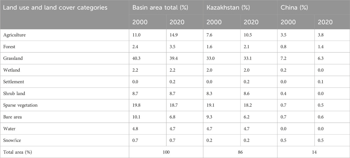
TABLE 1. Main land use characteristics of the selected Basin based on ESA CCI LC dataset (Zanaga et al., 2022).
Over the past 2 decades, the Balkhash Lake Basin has seen changes in land use (table 1). Agriculture expanded to 14.9%, forests to 3.5%, while grasslands remained dominant at 39.4%, and sparse vegetation slightly decreased to 18.7%. These changes, influenced by Kazakhstan and China, highlight the evolving landscape of the region.
2.2 Data sources
2.2.1 Satellite data
Our study utilized datasets from the MODIS (Moderate Resolution Imaging Spectroradiometer) instrument onboard NASA’s Terra and Aqua satellites. These datasets were employed to acquire information about vegetation and Earth system parameters. Notably, we focused on the Enhanced Vegetation Index (EVI) among the derived vegetation indices. These datasets were obtained from the following online sources: https://ladsweb.modaps.eosdis.nasa.gov/ and https://search.earthdata.nasa.gov/.
Within our research framework, the MODIS Enhanced Vegetation Index (EVI) dataset (MOD13A1) was produced through mathematical operations applied to surface reflectance data, covering the years 2000–2020. This approach leveraged the specific absorption characteristics of chlorophyll pigments in plant leaves, particularly within the red (670 nm) and blue (470 nm) spectra, in addition to the prominent scattering effects in the near-infrared (NIR) segment of the electromagnetic spectrum (Lu et al., 2015).
For assessing land surface thermal characteristics, the MODIS Land Surface Temperature (LST) product (MOD11C2), played a central role. This product was derived from thermal infrared bands, with a primary focus on bands 31 (10.780–11.280 µm) and 32 (11.770–12.270 µm), (Zhao et al., 2021).
Water Equivalent Thickness: Water Equivalent Thickness (WET) data, obtained from the GRACE-FO website (https://gracefo.jpl.nasa.gov) covering monthly records from 2003 to 2020, facilitated the assessment of water mass fluctuations through the GRACE and GRACE-FO satellites, monitoring changes in Earth’s mass. This study involved the analysis of Equivalent Water Thickness (EWT) changes from 2003 to 2020 using Level-2 Release-06 data from the Center for Space Research (CSR). Decorrelation Filtering (DDK) was employed at CSR as a method to mitigate correlation-based errors. Furthermore, EWT changes across various years were computed in regions exhibiting significant fluctuations. To enhance the analysis, the GRACE-based WET data underwent resampling to align with the 500 m by 500 m pixel resolution of the MODIS dataset. This process involved spatial interpolation and value averaging, employing a two-step approach (Duan et al., 2020). All data acquisition and processing procedures were conducted using Google Earth Engine (Gorelick et al., 2017) and Quantum GIS (Hugentobler, 2017).
Balkhash Lake area: Data for the Balkhash Lake area is sourced from the Land Use and Land Cover classification, which is extracted from the European Space Agency (ESA) Climate Change Initiative Land Cover (CCI LC) dataset spanning the years 1992–2020 at a 300-m spatial resolution (Defourny, 2017). The ESA compiled this global dataset using information from various satellite systems, including the Advanced Very High-Resolution Radiometer (AVHRR), Satellite Pour l’Observation de la Terre (SPOT) Vegetation, Medium Resolution Imaging Spectrometer (MERIS), and Sentinel systems (Hartley et al., 2017).
2.2.2 Hydrological data
The river water level data (RWL) in meters, as indicated in Figure 1, was based on observed monthly recordings. These data were collected over 21 years corresponding to the study duration and were sourced from four strategically situated hydrological stations along various rivers within the Balkhash Lake Basin. The official data source for this information is RSE “Kazhydromet”, the hydrometeorological organization in Kazakhstan, which provides access to these datasets via its official website at www.kazhydromet.kz.
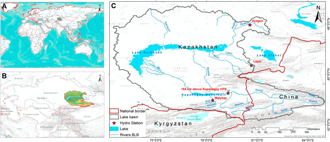
FIGURE 1. Overview of the study area. (A) World coverage, (B) study area in the Central Asia, and (C) Balkhash Lake Basin and its hydrological monitoring stations.
2.3 Calculation of the drought index
Drought evaluations within the endorheic basin were computed using the Vegetation Health Index (VHI) on a pixel-wise basis for the years 2000–2020, on a monthly scale, with a specific focus on the mean growing season from April to September. The computation of drought parameters relies on the utilization of MODIS datasets due to their exceptional spatial, spectral, and temporal resolutions (Chen et al., 2011). Subsequently, this data was employed in the computation of the Vegetation Condition Index (VCI), Temperature Condition Index (TCI), and the ultimate Drought Index, known as the Vegetation Health Index (VHI). The formula for VHI is expressed as follows:
Here, EVI max and EVI min indicate the highest and lowest EVI values within each observation period. As a standalone metric, the VCI serves as a valuable tool for drought assessment (Eq. 1). VCI has demonstrated a high level of accuracy in evaluating drought conditions, considering parameters such as duration and its impact on vegetation.
Here, LSTmax and LSTmin signify the uppermost and lowest values of Land Surface Temperature (LST). The TCI algorithm (Eq. 2) closely parallels the VCI methodology, with conditions being assessed concerning the maximum and minimum temperature envelope. The subsequent formula accounts for the distinct vegetation responses to temperature variations (Kogan, 1995).
VHI is a resultant metric obtained by computing a weighted average of two indices, with values ranging from 0 to 1. In accordance with the defined VHI formulation, both the TCI and the VCI were assigned equal weights of 0.5, as specified in Eq. 3. To facilitate calculations, the VHI values were subsequently multiplied by 100, resulting in a range spanning from 0 to 100. A VHI value of 0 indicates extremely arid conditions, while a maximum value of 100 signifies the most favorable wet conditions.
Drought severity classifications for VHI values less than 40 are employed to categorize the level of drought stress experienced by vegetation. These classifications are adaptable depending on the specific application and have been validated in previous research. VHI is categorized into five distinct classes utilizing predefined thresholds outlined in Table 2.
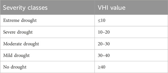
TABLE 2. Classification of drought calculated by the VHI (Kogan, 2002).
2.4 Probabilistic drought mapping
The recurrence, duration, and intensity of droughts are of paramount importance in water supply management, exacerbating the scarcity of natural water resources. To evaluate the likelihood of drought events, their occurrence probability was computed at the pixel level, encompassing the entire growth season timeframe. This probability (
The confidence interval for p’ is expressed as (Eq. 5):
Where:
2.5 Trend analysis
The evaluation of trends in environmental parameters is important for the progression and sustainable management of natural resources. In this study, a longitudinal assessment of change was conducted utilizing a linear methodology. Linear trends were calculated for both annual and monthly intervals spanning the period from 2000 to 2020. A straight line was fitted to the temporal data of each pixel using the least squares linear regression technique. The mathematical expression for the linear regression line can be stated as follows:
The regression line was constructed with x (time) as the independent variable and y (drought) as the dependent variable (Eq. 6). Here, a represents the intercept, while b signifies the slope of trend, depicting temporal changes at the pixel scale. Positive values of the trend indicate growth, whereas negative values indicate decline. Pearson’s correlation coefficients assessed the line’s fit, measuring the linear connection between datasets, with the significance level being evaluated at the 90%–99% confidence level.
3 Results
3.1 Drought distribution over Lake Basin
This study conducted an extensive assessment covering an area exceeding 470,826 square kilometers within the Balkhash Lake basin (Figure 2). The spatiotemporal characteristics of drought events exhibited notable variability and annual fluctuations, impacting the regional distribution of vegetation. Throughout the entire investigative period, the annual prevalence of drought, defined by the VHI falling below the threshold of 40, encompassed approximately 44% of the total basin area. Specifically, 86% of the total basin is situated in Kazakhstan, with 39% of this area experiencing drought. The remaining 14% pertains to the Chinese territory within the basin, of which 5% is affected by drought. Additionally, our research identified four specific years (2000, 2008, 2014, and 2015) as instances of severe drought episodes that affected the entirety of the basin, visually represented in Figures 2A, I, O, P.
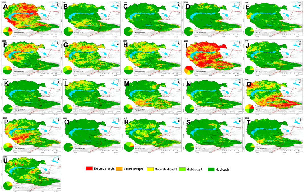
FIGURE 2. Spatiotemporal patterns of annual drought severity and respective proportions of drought categories for each year (A–U).
3.2 Drought characteristics
The drought characteristics of the basin, encompassing factors such as frequency and duration, were quantified by enumerating the annual occurrences of drought events between April and September. Drought severity was determined by summing the cumulative period characterized by severe to extreme conditions, as defined by VHI values ranging from 0 to 20, on a pixel-by-pixel basis. To assess both the duration and severity of drought events, we applied a probability-based relative frequency distribution function, as illustrated in Eq. 3. It is important to note that our analysis excluded moderate and mild drought occurrences, considering them as minor anomalies typical of arid regions.
The analysis of the geographic distribution of severe drought frequencies was conducted using a probabilistic framework (Figure 3). The results revealed that approximately 26% of the basin’s area experienced prolonged 3-year drought events. In parallel, about 17% of instances exhibited recurring 4-year drought episodes. Furthermore, roughly nine percent of the region displayed a recurring 5-year drought pattern, while seven percent of the basin’s geographical territory endured drought occurrences lasting beyond a 6-year duration.
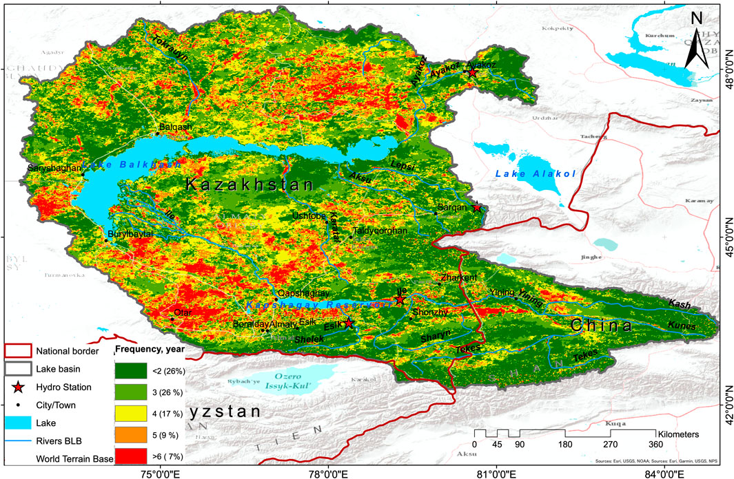
FIGURE 3. Spatial and temporal patterns of drought frequency.
3.3 Trend analysis of drought events over Lake Basin
Our scientific investigation, as illustrated in Figure 4, reveals noteworthy patterns of drought trend fluctuations within the assigned research zone. Specifically, we have identified a 23% surge in trend, predominantly concentrated in the northeastern and central areas of the study region, encompassing the Chinese part of the basin within cropland areas. Conversely, approximately 17% of the area has experienced a decline in trend, with focal points in the southern and northwestern sectors of the basin. Notably, 60% of the study area has displayed a state of relative constancy, devoid of any observable alterations in trend.
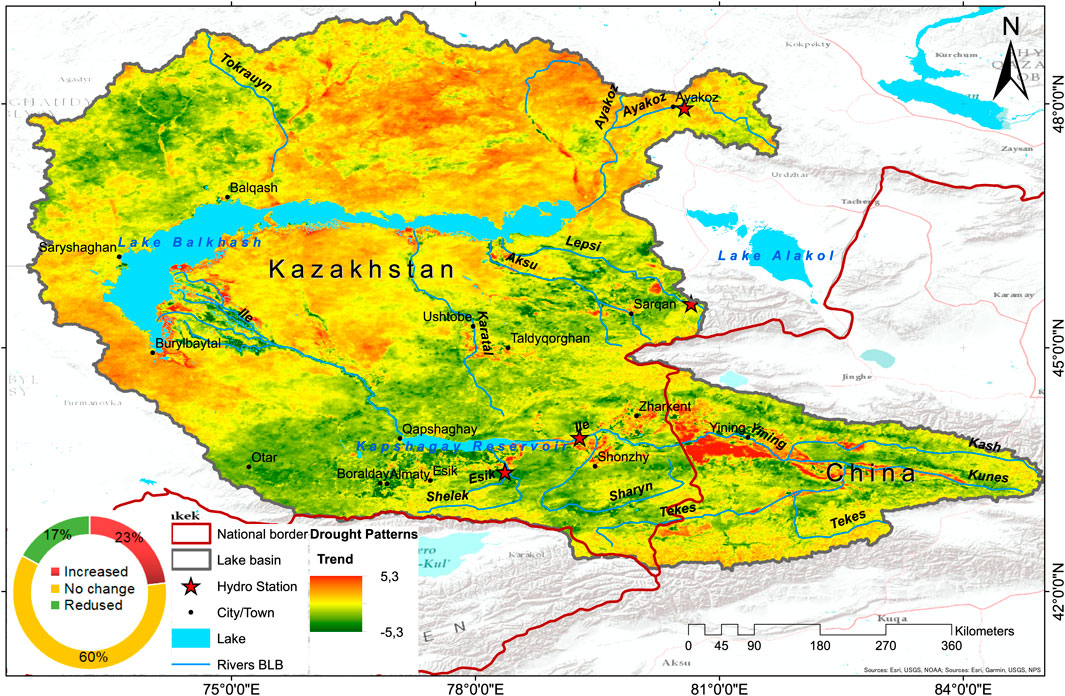
FIGURE 4. Spatiotemporal patterns of trend analysis.
Our study indicates consistent drought trends with slight variability. Various studies have explored the connection between drought and Land Surface Temperature (LST) and Vegetation Index VI) (Choi et al., 2013; Zhao et al., 2021). However, these indices differ in their principles and methods. A careful selection of the appropriate index is crucial for effective regional drought monitoring. VCI is recommended for vegetated areas due to its sensitivity, as indicated by Zhao et al. (2010), while TCI is better suited for desert regions.
The combined index between temperature and vegetation cover relies on their strong negative correlation. This is due to increased evaporation resulting from reduced soil moisture due to higher temperatures, leading to decreased vegetation cover. Therefore, researchers (Yao et al., 2019; Zhao et al., 2021) widely applied the Vegetation Health Index (VHI) in various areas, such as drought detection, severity assessment, crop and pasture loss evaluation due to drought, wildfire risk estimation, and early drought warnings.
In our comprehensive research, which encompassed selected stations situated at various elevations alongside different river systems, we uncovered notable correlations as follows:
At the Kapshagay station (Table 3, A), located along the Ile River at an elevation of 496 m above sea level, we found that: Drought and river water level displayed a moderate positive correlation with a coefficient of 0.55 (p < 0.01), indicating a statistically significant relationship, suggesting that as drought conditions intensified, there was a corresponding rise in river water levels. Furthermore, we identified a relatively strong positive correlation with a coefficient of 0.74 (p < 0.01) between drought and water equivalent thickness, signifying that as drought intensity increased, so did the water equivalent thickness, which reflects changes in snowpack and soil moisture. Additionally, we observed a statistically significant correlation of 0.4 (p < 0.1) between the Balkhash Lake area and water equivalent thickness, suggesting that changes in the Balkhash Lake area were associated with variations in water equivalent thickness, albeit with a slightly weaker correlation compared to the previous associations.
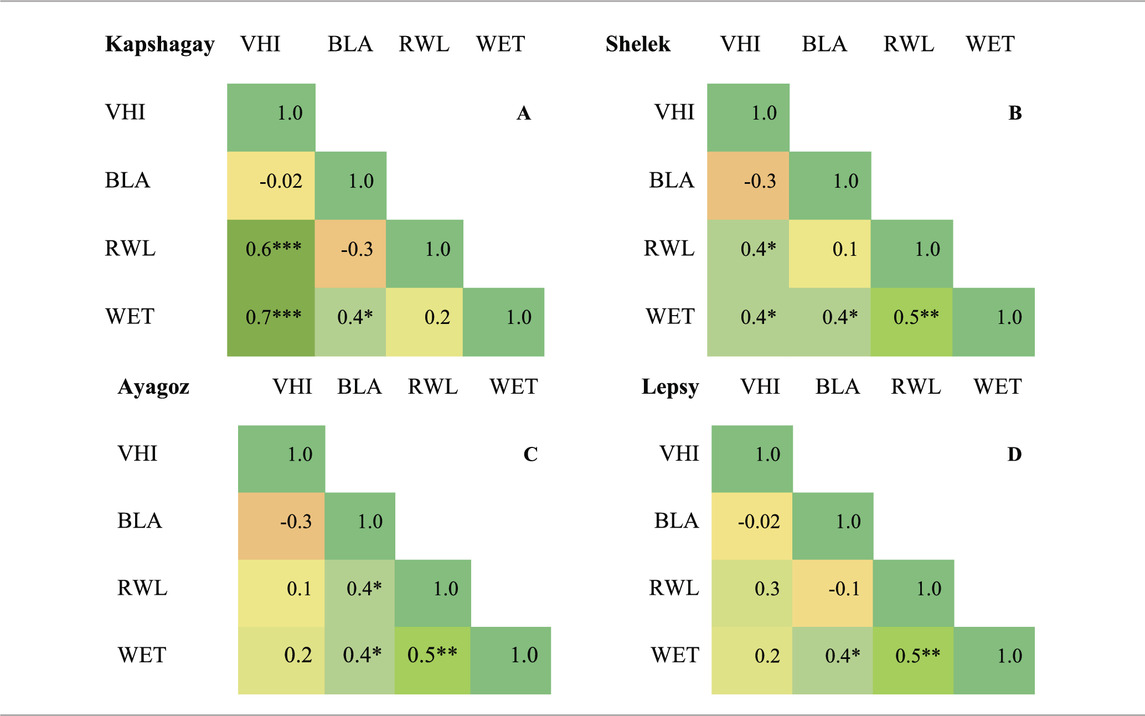
TABLE 3. Correlation Matrix Plot of selected indices with significance levels indicated by asterisks: p < 0,1 (*), p < 0,05 (**), and p < 0,01 (***).
In a scientific study conducted at the Shelek station (Table 3, B), situated at an elevation of 845 m, several significant correlations were identified between various environmental factors. The results are as follows: A moderate positive correlation (r = 0.4, p < 0.1) was observed between drought and river water levels, indicating that as drought conditions intensified, river water levels tended to decrease. Similarly, a moderate positive correlation (r = 0.4, p < 0.1) was found between drought and water equivalent thickness, suggesting that during periods of drought, the water equivalent thickness also tended to decrease. Another correlation was identified between the Balkhash Lake area and water equivalent thickness, revealing a weak positive correlation (r = 0.42) between these two variables. This implies that as the area of Balkhash Lake changed, there was a slight influence on water equivalent thickness values. Lastly, a high positive correlation (r = 0.5, p < 0.05) was detected between water equivalent thickness and river water level, indicating a strong relationship between these two variables. As water equivalent thickness increased, river water levels tended to rise significantly.
In the study conducted at the Ayagoz station, situated at an elevation of 648 m, we observed the following correlations (Table 3, C): There was no notable correlation between drought and other tested parameters. However, a significant correlation was found between the Balkhash Lake area and both river water level and water equivalent thickness, with a coefficient of 0.4 (p < 0.1). Furthermore, a robust correlation of 0.5 (p < 0.05) was identified between river water level and water equivalent thickness, demonstrating a strong relationship between these two variables. These findings provide valuable insights into the relationships among drought, Balkhash Lake area, river water level, and water equivalent thickness at the Ayagoz station, contributing to our understanding of local hydrological and environmental dynamics.
At the Lepsy station (Table 3, D), situated at an elevation of 1,348 m, our scientific investigation yielded the following results: No statistically significant correlation was discerned between drought and the examined parameters. Drought exhibited no discernible relationship with these variables at this specific station. A correlation coefficient of 0.4 (p < 0.1) was identified between the Balkhash Lake area and water equivalent thickness. This correlation suggests an association between alterations in the size of Balkhash Lake and fluctuations in water equivalent thickness, albeit with a relatively modest strength of relationship. A robust positive correlation, quantified at 0.5 (p < 0.05), was observed between river water level and water equivalent thickness. This substantial correlation underscores a pronounced connection between these two variables, signifying that variations in water equivalent thickness exert a substantial influence on river water levels at the Lepsy station.
4 Discussion
In Central Asia, drought emerges as a potent force significantly influencing agriculture and food security, posing varied water-related challenges for crop yield and farm profitability (Xu et al., 2015). Over the two-decade study period (2000–2020), 44% of the total basin area grappled with drought, with 39% in Kazakhstan and 5% in the Chinese part (figure 5), underscoring implications for the country’s agriculture given the expansive land dedicated to farming and livestock (Dubovyk et al., 2019). During severe drought years (2000, 2008, 2014, and 2015), the entire basin faced evident challenges, causing substantial consequences for regional vegetation and highlighting the ecosystem’s vulnerability to climate-induced hardships. Rain-fed agricultural areas were particularly susceptible to substantial losses during droughts, impacting both agriculture and river water flow (De Beurs and Henebry, 2004; Aitekeyeva et al., 2020). Results emphasized a significant decrease in rainfall during the vegetation growing season, coupled with higher mean annual temperatures during these drought years (Hashemi et al., 2022).
Repeated droughts pose significant threats to lake and wetland systems, limiting the productivity of terrestrial ecosystems (Zhang et al., 2017; Guo et al., 2018). They also lead to issues such as extended dry periods, escalating the occurrence of wildfires in grasslands, forests, and pastures. In our research, the analysis of drought characteristics revealed distinct patterns: 26% of basins experience prolonged 3-year droughts, 17% face recurring 4-year droughts, approximately 9% undergo repeated 5-year droughts, and a notable 7% experience droughts lasting more than 6 years (Yegizbayeva et al., 2022). The increasing frequency, severity, and duration of droughts in least developed countries, including the region, are further exacerbating the situation (Miyan, 2015). Aligning with our study, Yang Q. et al. (2022), emphasized 53 drought events occurring from 1901 to 2020 in the Lake Balkhash basin, emphasizing isolated episodes of severe drought in 2007–2009 and highlighting the persistent and cyclical nature of drought. Guo et al. (2018) also underscored a drying trend in Central Asia between 2003 and 2015, excluding northern Kazakhstan, and identified a 16–64-month periodic oscillation. Drought changes are primarily linked to ENSO and the North Atlantic Oscillation, with the strength of the Siberian High playing a significant role in drought variations, particularly in the Balkhash Lake Basin area of eastern Central Asia (Chen et al., 2018).
The long-term trend evaluation revealed a 23% increase in drought severity in a noticeable proportion of the region, with 17% witnessing a decline and 60% exhibiting relative stability. Spatial heterogeneity in drought trends emphasized the need for localized interventions and adaptive strategies, considering variations in the region (Guo et al., 2018). This approach optimizes resource allocation and efforts to enhance resilience, addressing areas facing deteriorating conditions while not neglecting those that remain relatively stable (Ta et al., 2018). The study highlights the importance of considering local variations when developing drought mitigation and adaptation plans, acknowledging the unsuitability of a one-size-fits-all approach for the entire region (Fang et al., 2010).
Exploring relationships between drought and hydrological parameters (RWL, WET) at selected stations within the Balkhash Lake Basin revealed diverse hydrological consequences. Correlations provided valuable insights into the interconnectedness of drought and the region’s water dynamics. Findings underscored complex relationships between drought and hydrological factors, emphasizing the need for a nuanced understanding to inform effective water resource management and climate adaptation strategies in the region. Yespolov et al. (2022) concurred, emphasizing the need to address challenges in sustainable water management for Kazakhstan’s agriculture sectors, aligning with the water-rich Balkhash Lake Basin facing escalating water scarcity and drought events. Myrzakhmetov et al. (2022) highlighted hydrological fluctuations in the Lake Balkhash region from 1998 to 2005, with a notable rise in water level attributed to increased inflow linked to higher humidity and air temperature. Subsequently, a decline of 32 cm occurred from 2006 to 2009. However, in 2010, a reversal took place, leading to a 15 cm increase, reaching 342.36 m. BS. Talipova et al. (2019) identified significant station-based alterations in temperature and precipitation patterns within the Balkhash Lake Basin, necessitating the adoption of sustainable water resource management practice (Tursunova et al., 2022). Despite the limited availability of literature for a direct comparison with our findings, the challenges posed by drought and evolving climate patterns underscore the urgency of implementing sustainable water resource management practices. To effectively address the specific vulnerabilities and correlations identified at different stations within the basin, it is imperative to incorporate these considerations into water resource management practices. The utilization of our probabilistic mapping of drought occurrences serves as a valuable tool for enhancing water supply management, facilitating anticipation, and enabling strategic planning for drought events. The study underscores the critical importance of proactive monitoring and assessment, leveraging remote sensing data and comprehensive indices like VHI, to bridge existing research gaps in the region.
5 Conclusion
In conclusion, this study has provided valuable insights into the dynamics of drought within the Balkhash Lake Basin for the period spanning from 2000 to 2020. The research has revealed the significant and enduring impacts of severe drought events on the region, affecting a substantial portion of the basin’s area and posing challenges for both Kazakhstan and China. The analysis of temporal trends has uncovered a mixed scenario, with certain areas experiencing deteriorating drought conditions while others maintain relative stability, underscoring the spatial heterogeneity of drought patterns within the region.
Moreover, the research has unveiled complex correlations between drought occurrences and hydrological parameters at monitoring stations in the basin, emphasizing the complex interplay between these factors. This highlights the critical importance of nuanced and localized approaches to water resource management in addressing the region’s vulnerabilities effectively.
In light of the recurring drought events and the challenges brought about by evolving climate patterns, this study serves as a call to action, underlining the urgent need for proactive monitoring, adaptive strategies, and the adoption of sustainable water management practices to safeguard the vital water resources and ecosystems of the Balkhash Lake Basin. The region faces heightened challenges due to the simultaneous trends of increasing temperatures and population growth, intensifying the overall impact on water availability.
Therefore, comprehensive and localized strategies are essential to address the varying degrees of vulnerability across the basin, with the research offering a novel perspective that can inform tailored approaches for managing water resources and adapting to climate changes in this specific geographical context, thereby revealing previously unexplored avenues of research.
Data availability statement
The raw data supporting the conclusion of this article will be made available by the authors, without undue reservation.
Author contributions
AY: Writing–original draft, Funding acquisition, Writing–review and editing. AK: Methodology, Writing–review and editing. NB: Funding acquisition, Writing–review and editing. DA: Conceptualization, Data curation, Writing–review and editing. NaA: Writing–original draft. NuA: Writing–review and editing.
Funding
The author(s) declare financial support was received for the research, authorship, and/or publication of this article. This study received financial support from the Ministry of Agriculture of the Republic of Kazakhstan for the project titled “Technologies and Technical Means of Irrigation for the Establishment of New Irrigated Lands, Reconstruction, and Modernization of Existing Irrigation Systems” during the period from 2021 to 2023 (IRN—BR10764920). Additionally, this study forms a part of AY’s Ph.D. research at Al-Farabi Kazakh National University.
Acknowledgments
The authors express their gratitude to the editor and reviewers for their valuable comments and suggestions, which greatly enhanced the quality of this paper.
Conflict of interest
The authors declare that the research was conducted in the absence of any commercial or financial relationships that could be construed as a potential conflict of interest.
Publisher’s note
All claims expressed in this article are solely those of the authors and do not necessarily represent those of their affiliated organizations, or those of the publisher, the editors and the reviewers. Any product that may be evaluated in this article, or claim that may be made by its manufacturer, is not guaranteed or endorsed by the publisher.
References
Aitekeyeva, N., Li, X., Guo, H., Wu, W., Shirazi, Z., Ilyas, S., et al. (2020). Drought risk assessment in cultivated areas of central asia using MODIS time-series data. Water 12, 1738. doi:10.3390/w12061738
Alimkulov, S. K., and Moldakhanova, N. E. (2020). Ecological state of the wetlands of Ile River delta.
Aralova, D., Toderich, K., Jarihani, A., Gafurov, D., Gismatulina, L., Osunmadewa, B. A., et al. (2016). Environmental resilience of rangeland ecosystems: assessment drought indices and vegetation trends on arid and semi-arid zones of Central Asia. Earth Resour. Environ. Remote Sens. 10005, 2242563. doi:10.1117/12.2242563
Berdimbetov, T., Ma, Z., Nietullaeva, S., and Yegizbayeva, A. (2021). Analysis of impact of aral sea catastrophe on anomaly climate variables and hydrological processes. Int. J. Geoinformatics 17, 65–74. doi:10.52939/ijg.v17i1.1711
Chen, C. F., Son, N. T., Chang, L. Y., and Chen, C. C. (2011). Monitoring of soil moisture variability in relation to rice cropping systems in the Vietnamese Mekong Delta using MODIS data. Appl. Geogr. 31, 463–475. doi:10.1016/j.apgeog.2010.10.002
Chen, F., Yuan, Y., Chen, F. H., WeiShou, W. Y., Long, S., Chen, X., et al. (2013). A 426-year drought history for western tian Shan, central asia, inferred from tree rings and linkages to the North Atlantic and indo-west pacific oceans. Holocene 23, 1095–1104. doi:10.1177/0959683613483614
Chen, X., Wang, S., Hu, Z., Zhou, Q., and Hu, Q. (2018). Spatiotemporal characteristics of seasonal precipitation and their relationships with ENSO in Central Asia during 1901–2013. J. Geogr. Sci. 28, 1341–1368. doi:10.1007/s11442-018-1529-2
Choi, M., Jacobs, J. M., Anderson, M. C., and Bosch, D. D. (2013). Evaluation of drought indices via remotely sensed data with hydrological variables. J. Hydrol. 476, 265–273. doi:10.1016/j.jhydrol.2012.10.042
De Beurs, K. M., and Henebry, G. M. (2004). Land surface phenology, climatic variation, and institutional change: analyzing agricultural land cover change in Kazakhstan. Remote Sens. Environ. 89, 497–509. doi:10.1016/j.rse.2003.11.006
De Boer, T., Paltan, H., Sternberg, T., and Wheeler, K. (2021). Evaluating vulnerability of central asian water resources under uncertain climate and development conditions: the case of the ili-balkhash basin. WaterSwitzerl. 13, 615. doi:10.3390/w13050615
Defourny, P. (2017). CCI-LC Product user guide version 2. ESA L. Cover Clim. Chang. Initiat. L. Cover Maps, v2.0.7. Cent. Environ. Data Anal. 87.
Deng, H., and Chen, Y. (2017). Influences of recent climate change and human activities on water storage variations in Central Asia. J. Hydrol. 544, 46–57. doi:10.1016/j.jhydrol.2016.11.006
Dorjsuren, M., Liou, Y. A., and Cheng, C. H. (2016). Time series MODIS and in situ data analysis for Mongolia drought. Remote Sens. 8, 509–516. doi:10.3390/rs8060509
Dragos, S. L., Mare, C., Dragos, C. M., Muresan, G. M., and Purcel, A.-A. (2022). Does voluntary health insurance improve health and longevity? Evidence from European OECD countries. Eur. J. Heal. Econ. 23, 1397–1411. doi:10.1007/s10198-022-01439-9
Duan, W., Zou, S., Chen, Y., Nover, D., Fang, G., and Wang, Y. (2020). Sustainable water management for cross-border resources: the balkhash Lake Basin of central asia, 1931–2015. J. Clean. Prod. 263, 121614. doi:10.1016/j.jclepro.2020.121614
Dubovyk, O., Ghazaryan, G., González, J., Graw, V., Löw, F., and Schreier, J. (2019). Drought hazard in Kazakhstan in 2000–2016: a remote sensing perspective. Environ. Monit. Assess. 191, 510. doi:10.1007/s10661-019-7620-z
Fang, K., Davi, N., Gou, X., Chen, F., Cook, E., Li, J., et al. (2010). Spatial drought reconstructions for central High Asia based on tree rings. Clim. Dyn. 35, 941–951. doi:10.1007/s00382-009-0739-9
Forkel, M., Carvalhais, N., Verbesselt, J., Mahecha, M. D., Neigh, C. S. R., and Reichstein, M. (2013). Trend Change detection in NDVI time series: effects of inter-annual variability and methodology. Remote Sens. 5, 2113–2144. doi:10.3390/rs5052113
Gorelick, N., Hancher, M., Dixon, M., Ilyushchenko, S., Thau, D., and Moore, R. (2017). Google earth engine: planetary-scale geospatial analysis for everyone. Remote Sens. Environ. 202, 18–27. doi:10.1016/j.rse.2017.06.031
Guo, H., Bao, A., Liu, T., Jiapaer, G., Ndayisaba, F., Jiang, L., et al. (2018). Spatial and temporal characteristics of droughts in Central Asia during 1966–2015. Sci. Total Environ. 624, 1523–1538. doi:10.1016/j.scitotenv.2017.12.120
Hamidov, A., Helming, K., and Balla, D. (2016). Impact of agricultural land use in Central Asia: a review. Agron. Sustain. Dev. 36, 6–23. doi:10.1007/s13593-015-0337-7
Hartley, A. J., MacBean, N., Georgievski, G., and Bontemps, S. (2017). Uncertainty in plant functional type distributions and its impact on land surface models. Remote Sens. Environ. 203, 71–89. doi:10.1016/j.rse.2017.07.037
Hashemi, M. G. Z., Abhishek, A., Jalilvand, E., Jayasinghe, S., Andreadis, K. M., Siqueira, P., et al. (2022). Assessing the impact of Sentinel-1 derived planting dates on rice crop yield modeling. Int. J. Appl. Earth Obs. Geoinf. 114, 103047. doi:10.1016/j.jag.2022.103047
Herrera-Estrada, J. E., Satoh, Y., and Sheffield, J. (2017). Spatiotemporal dynamics of global drought. Geophys. Res. Lett. 44, 2254–2263. doi:10.1002/2016GL071768
Hugentobler, M. (2017). “Quantum GIS,” in Encycl. GIS (Cham: Springer), 1707–1712. doi:10.1007/978-3-319-17885-1_1064
Jiao, J. J., Zhang, X., Liu, Y., and Kuang, X. (2015). Increased water storage in the qaidam basin, the North tibet plateau from GRACE gravity data. PLoS One 10, 01414422. doi:10.1371/journal.pone.0141442
Karthe, D. (2018). Environmental changes in central and east asian drylands and their effects on major river-lake systems. Quat. Int. 475, 91–100. doi:10.1016/j.quaint.2017.01.041
Kogan, F. (2002). World droughts in the new millennium from avhrr-based vegetation health indices. Eos Wash. DC) 83, 557–563. doi:10.1029/2002EO000382
Kogan, F. N. (1995). Application of vegetation index and brightness temperature for drought detection. Adv. Sp. Res. 15, 91–100. doi:10.1016/0273-1177(95)00079-T
Kogutenko, L., Severskiy, I., Shahgedanova, M., and Lin, B. (2019). Change in the extent of glaciers and glacier runoff in the Chinese sector of the Ile River basin between 1962 and 2012. WaterSwitzerl. 11, 1668–1724. doi:10.3390/w11081668
Kyrgyzbay, K., Kakimzhanov, Y., and Sagin, J. (2023). Climate data verification for assessing climate change in Almaty region of the Republic of Kazakhstan. Clim. Serv. 32, 100423. doi:10.1016/j.cliser.2023.100423
Liang, L., Qiu, S., Yan, J., Shi, Y., and Geng, D. (2021). Vci-based analysis on spatiotemporal variations of spring drought in China. Int. J. Environ. Res. Public Health 18, 7967. doi:10.3390/ijerph18157967
Lopez Fernandez, M. L., Zhumabayev, D., Garcia, R. M., Baigarin, K., Lopez Fernandez, M. S., and Baisholanov, S. (2020). Assessment of bioclimatic change in Kazakhstan, end 20th—middle 21st centuries, according to the PRECIS prediction. PLoS One 15 (10), e0239514. doi:10.1371/journal.pone.0239514
Lu, L., Kuenzer, C., Wang, C., Guo, H., and Li, Q. (2015). Evaluation of three MODIS-derived vegetation index time series for dryland vegetation dynamics monitoring. Remote Sens. 7, 7597–7614. doi:10.3390/rs70607597
Mishra, A. K., and Singh, V. P. (2010). A review of drought concepts. J. Hydrol. 391, 202–216. doi:10.1016/j.jhydrol.2010.07.012
Miyan, M. A. (2015). Droughts in asian least developed countries: vulnerability and sustainability. Weather Clim. Extrem. 7, 8–23. doi:10.1016/j.wace.2014.06.003
Mohammat, A., Wang, X., Xu, X., Peng, L., Yang, Y., Zhang, X., et al. (2013). Drought and spring cooling induced recent decrease in vegetation growth in Inner Asia. Agric. For. Meteorol. 178–179, 21–30. doi:10.1016/j.agrformet.2012.09.014
Moldakhanova, N., Alimkulov, S., and Smagulov, Z. (2023). Analysis of changes in the ecological space of the Ili River delta (due to reduced flow of the Ili River). Evergreen 10, 29–35. doi:10.5109/6781031
Myrzakhmetov, A., Dostay, Z., Alimkulov, S., Tursunova, A., and Sarsenova, I. (2022). Level regime of Balkhash Lake as the indicator of the state of the environmental ecosystems of the region. Paddy Water Environ. 20, 315–323. doi:10.1007/s10333-022-00890-x
Nurtazin, S., Pueppke, S., Ospan, T., Mukhitdinov, A., and Elebessov, T. (2020). Quality of drinking water in the Balkhash district of Kazakhstan’s almaty region. WaterSwitzerl. 12, 392. doi:10.3390/w12020392
Poulsen, L., Michael, M., and Pearson, N. (2007). Drought and Vulnerability - a review of context, capacity and appropriate interventions with respect to drought and the problem of acute malnutritionin the Sahel Region of West Africa. 100. Available at: http://ec.europa.eu/echo/files/policies/evaluation/2007/west_africa_sahel.pdf.
Qi, J., Tao, S., Pueppke, S. G., Espolov, T. E., Beksultanov, M., Chen, X., et al. (2020a). Changes in land use/land cover and net primary productivity in the transboundary ili-balkhash basin of central asia, 1995–2015. Environ. Res. Commun. 2, 011006. doi:10.1088/2515-7620/ab5e1f
Qi, J., Tao, S., Pueppke, S. G., Espolov, T. E., Beksultanov, M., Chen, X., et al. (2020b). Changes in land use/land cover and net primary productivity in the transboundary Ili-Balkhash basin of Central Asia, 1995–2015. Environ. Res. Commun. 2, 011006. doi:10.1088/2515-7620/ab5e1f
Ren, G., Zhou, Y., Chu, Z., Zhou, J., Zhang, A., Guo, J., et al. (2008). Urbanization effects on observed surface air temperature trends in North China. J. Clim. 21, 1333–1348. doi:10.1175/2007JCLI1348.1
Salnikov, V., Talanov, Y., Polyakova, S., Assylbekova, A., Kauazov, A., Bultekov, N., et al. (2023). An assessment of the present trends in temperature and precipitation extremes in Kazakhstan. Climate 11, 33. doi:10.3390/cli11020033
Satish Kumar, K., Venkata Rathnam, E., and Sridhar, V. (2021). Tracking seasonal and monthly drought with GRACE-based terrestrial water storage assessments over major river basins in South India. Sci. Total Environ. 763, 142994. doi:10.1016/j.scitotenv.2020.142994
Sreekesh, S., Kaur, N., and Naik, S. S. R. (2019). Agricultural drought and soil moisture analysis using satellite image based indices. Int. Arch. Photogramm. Remote Sens. Spat. Inf. Sci. - ISPRS Arch. 42, 507–514. doi:10.5194/isprs-archives-XLII-3-W6-507-2019
Sun, Y., Chen, X., Yu, Y., Qian, J., Wang, M., Huang, S., et al. (2022). Spatiotemporal characteristics of drought in central asia from 1981 to 2020. Atmos. (Basel) 13, 1496. doi:10.3390/atmos13091496
Ta, Z., Yu, R., Chen, X., Mu, G., and Guo, Y. (2018). Analysis of the spatio-temporal patterns of dry and wet conditions in Central Asia. Atmos. (Basel) 9, 7. doi:10.3390/atmos9010007
Talipova, E., Shrestha, S., Alimkulov, S., Nyssanbayeva, A., Tursunova, A., and Isakan, G. (2021). Influence of climate change and anthropogenic factors on the Ile River basin streamflow, Kazakhstan. Arab. J. Geosci. 14, 1756. doi:10.1007/s12517-021-08152-6
Talipova, E. K., Nyssanbayeva, A. S., and Shrestha, S. (2019). Established fact. In accordance with the results of Climate in 2017, 2018) that the global average the atmosphere as a result of human economic activity the Synthesis Report (WMO Statement on the Status of Global Climate in 2017, 2018) the main caus.
Tursunova, A., Medeu, A., Alimkulov, S., Saparova, A., and Baspakova, G. (2022). Water resources of Kazakhstan in conditions of uncertainty. J. Water L. Dev. 54, 138–149. doi:10.24425/jwld.2022.141565
Vernieuwe, H., De Baets, B., and Verhoest, N. E. C. (2020). A mathematical morphology approach for a qualitative exploration of drought events in space and time. Int. J. Climatol. 40, 530–543. doi:10.1002/joc.6226
Wolff, C., Plessen, B., Dudashvili, A., Breitenbach, S. F. M., Cheng, H., Edwards, R. L., et al. (2016). Precipitation evolution of Central Asia during the last 5000 years. Holocene press 2016, 1–39. doi:10.1177/0959683616652711
Xu, K., Yang, D., Yang, H., Li, Z., Qin, Y., and Shen, Y. (2015). Spatio-temporal variation of drought in China during 1961-2012: a climatic perspective. J. Hydrol. 526, 253–264. doi:10.1016/j.jhydrol.2014.09.047
Yang, Q., Shi, L., Han, J., Chen, Z., and Yu, J. (2022a). A VI-based phenology adaptation approach for rice crop monitoring using UAV multispectral images. F. Crop. Res. 277, 108419. doi:10.1016/j.fcr.2021.108419
Yang, X., Li, Y. P., Huang, G. H., and Zhang, S. Q. (2022b). Analyzing spatial–temporal change of multivariate drought risk based on Bayesian copula: application to the Balkhash Lake basin. Theor. Appl. Climatol. 149, 787–804. doi:10.1007/s00704-022-04062-z
Yao, J., Hu, W., Chen, Y., Huo, W., Zhao, Y., Mao, W., et al. (2019). Hydro-climatic changes and their impacts on vegetation in Xinjiang, Central Asia. Sci. Total Environ. 660, 724–732. doi:10.1016/j.scitotenv.2019.01.084
Yapiyev, V., Sagintayev, Z., Inglezakis, V. J., Samarkhanov, K., and Verhoef, A. (2017). Essentials of endorheic basins and lakes: a review in the context of current and futurewater resource management and mitigation activities in Central Asia. WaterSwitzerl. 9, 798. doi:10.3390/w9100798
Yegizbayeva, A., Ilyas, S., and Berdimbetov, T. (2022). Drought characterisation of syrdarya river basin in central asia using reconnaissance drought index. Int. Geosci. Remote Sens. Symp. 2022, 6356–6359. doi:10.1109/IGARSS46834.2022.9883653
Yespolov, T., Tireuov, K., and Kerimova, U. (2022). Water resources in agriculture of the Republic of Kazakhstan: a view of scientists on rational use, prospects and management. Probl. AgriMarket 182, 155–163. doi:10.46666/2022-3.2708-9991.17
Zanaga, D., Van De Kerchove, R., Daems, D., De Keersmaecker, W., Brockmann, C., Kirches, G., et al. (2022). ESA WorldCover 10 m 2021 v200. Meteosat second gener. Evapotranspiration. Available at: https://worldcover2021.esa.int/data/docs/WorldCover_PUM_V2.0.pdf.
Zhang, D., Chen, P., Zhang, Q., and Li, X. (2017). Copula-based probability of concurrent hydrological drought in the Poyang lake-catchment-river system (China) from 1960 to 2013. J. Hydrol. 553, 773–784. doi:10.1016/j.jhydrol.2017.08.046
Zhang, X. P., Li, R. F., Lei, S., Fu, Q., and Wang, X. X. (2011). The study of dynamic monitor of rice drought in Jiangxi province with remote sensing. Procedia Environ. Sci. 10, 1847–1853. doi:10.1016/j.proenv.2011.09.289
Zhao, N., Yang, Y., and Zhou, X. (2010). Application of geographically weighted regression in estimating the effect of climate and site conditions on vegetation distribution in Haihe Catchment, China. Plant Ecol. 209, 349–359. doi:10.1007/s11258-010-9769-y
Zhao, X., Xia, H., Pan, L., Song, H., Niu, W., Wang, R., et al. (2021). Drought monitoring over yellow river basin from 2003–2019 using reconstructed MODIS land surface temperature in google earth engine. Remote Sens. 13, 3748. doi:10.3390/rs13183748
Zhupankhan, A., Tussupova, K., and Berndtsson, R. (2018). Water in Kazakhstan, a key in Central Asian water management. Hydrol. Sci. J. 63, 752–762. doi:10.1080/02626667.2018.1447111
Keywords: drought conditions, vegetation health index (VHI), hydrological parameters, Balkhash lake basin, Central Asia
Citation: Yegizbayeva A, Koshim AG, Bekmuhamedov N, Aliaskarov DT, Alimzhanova N and Aitekeyeva N (2024) Satellite-based drought assessment in the endorheic basin of Lake Balkhash. Front. Environ. Sci. 11:1291993. doi: 10.3389/fenvs.2023.1291993
Received: 10 September 2023; Accepted: 29 December 2023;
Published: 15 January 2024.
Edited by:
Daniel D. Snow, University of Nebraska-Lincoln, United StatesReviewed by:
Jie Zhou, Central China Normal University, ChinaKatelyn Lawson, Auburn University, United States
Copyright © 2024 Yegizbayeva, Koshim, Bekmuhamedov, Aliaskarov, Alimzhanova and Aitekeyeva. This is an open-access article distributed under the terms of the Creative Commons Attribution License (CC BY). The use, distribution or reproduction in other forums is permitted, provided the original author(s) and the copyright owner(s) are credited and that the original publication in this journal is cited, in accordance with accepted academic practice. No use, distribution or reproduction is permitted which does not comply with these terms.
*Correspondence: Asset Yegizbayeva, YXNzZXRAc3BhY2VyZXMua3o=