 Kai Bian
 Cuiping Wang2*
 Yulong Shen
95% of researchers rate our articles as excellent or good
Learn more about the work of our research integrity team to safeguard the quality of each article we publish.
Find out more
ORIGINAL RESEARCH article
Front. Environ. Sci. , 09 November 2023
Sec. Drylands
Volume 11 - 2023 | https://doi.org/10.3389/fenvs.2023.1291707
This article is part of the Research Topic Wind-Blown Sand and Water Sediment Processes and Disaster Control Strategies in Cold and Arid Regions View all 6 articles
This paper presents measurements of cesium-137 (137Cs) in the Qaidam Basin during 2019 with 39 soil samples across the landscape. The aim here is to use the results of 137Cs inventories for the Qaidam Basin to subsequently estimate soil wind erosion. The 137Cs inventories in the surface soil vary from lower limit detection (LDD) to 1,072 Bq m−2, with a mean of 266 Bq m−2. Overall, the 137Cs inventories in the Qaidam Basin decreases from southeast to northwest. The highest 137Cs inventories was found in farmland, and the lowest was found in Gobi. Wetlands had higher 137Cs inventories than their neighboring sites.
137Cs with half-life of 30.17 yrs was produced by nuclear weapon tests from the 1950s to the 1970s and nuclear accidents (e.g., Chernobyl in Ukraine, 1986; Fukushima in Japan, 2011) and was distributed globally as both wet and dry fallout (Ritchie and McHenry, 1990; Hedvall et al., 1996). On Earth, 137Cs is strongly and rapidly adsorbed by cation exchange sites on clay and organic soil particles and it cannot significantly migrate or take part in the chemical processes running in soil (Ritchie et al., 1974). Vertical diffusion of 137Cs limited depth redistribution reaching usually less than 20 cm results from bioturbation such as earthworms drilling up, physical chemical processes such as freezing-thawing or wetting-drying of soils. Its redistribution is often accompanied by physical transformations in soil, including through water, wind erosion and plowing (Ritchie et al., 1974; McHenry and Ritchie, 1977). These properties make 137Cs a valuable fingerprint for distinguishing surface and subsurface sediment sources and surface sources influenced by mixing and disturbance (Walling and He, 1999). However, the distribution of 137Cs across the planet is not uniform and mainly depends on local rainfall distribution patterns and latitudes. Deposition in the northern hemisphere is approximately three to four times that of all 137Cs in the southern hemisphere because most tests and nuclear accidents have occurred in the northern hemisphere (Zapata, 2002).
In China, studies related to the determination of 137Cs in soil have been published for most regions of the Qinghai-Tibetan Plateau but at a small scale because of the high altitudes and harsh environments of the Qinghai-Tibetan Plateau (Yan P, et al., 2000; Yan et al., 2001; Yan and Dong, 2003; Zhang, et al., 2007; Wang et al., 2017; Jiang et al., 2018; Li et al., 2019). The spatial distribution of 137Cs in soils in the Qaidam Basin has not been previously reported for this region. The objectives of this study are to determine the distribution of the radionuclide under representative land covers and land uses in the region, compare patterns of 137Cs gain and loss associated with different land uses in the Qaidam Basin, and analyze the factors controlling the variation in 137Cs activities. The data can be used to identify the distribution of these artificial radionuclides in soils and to estimate the total deposition (inventory) to assess any radiological impact.
The Qaidam Basin is located on the northern edge of the Tibetan Plateau between latitudes 25°55′49″ and 39°47′43″ and has an area of approximately 256,000 km2. The Qaidam Basin has a typical plateau continental climate, with cold conditions, drought, and rare precipitation that varies from approximately 300 mm in the southeast to <20 mm in the northwest. The westerlies are the major mode of circulation over the basin; strong prevailing north and northwest winds occur in winter and spring, and wind erosion mainly occurs from March to May (Du et al., 2018). The vegetation in the Qaidam Basin is sparse and simple and mainly consists of shrubs and semishrubs with high drought resistance ability, which exhibit a decreasing trend from the southeast to the northwest regions (Zhang, et al., 2019).
Bulk soil samples to quantify 137Cs inventories were collected at 39 sampling points in 2019. Sampling points along roads were located 20–40 km from each other. All samples were chosen at locations approximately 100 m away from the road, which should represent local conditions. The sampling sites were chosen to represent most of the geographic regions of the Qaidam Basin, as well as the geology, soils and amount of precipitation. The sites were grouped into six categories according to land use type: farmland, abandoned land, desert, desert steppe, wetland and Gobi, with numbers of sites of 5, 2, 11, 5, 3 and 13. At every site, three replicate samples in a triangle with sides about 20 m were collected using a stainless steel soil probe (inner diameter: 4.4 cm). And three replicate cores close to each other was taken at triangle’s every vertices down to a depth of 0.2 m and was bulked to represent the individual sample (ca 800 g). (Figure 1).
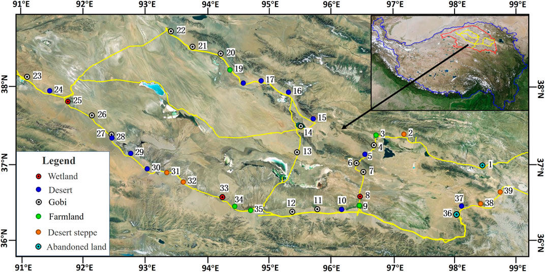
FIGURE 1. Sample collection sites in the Qaidam Basin.
After drying at room temperature until weighing each soil sample, pieces of vegetation and stones were removed; then, they were milled and passed through a 2 mm mesh sieve. After a quartering mixing process, approximately 300 g of each sample (≤2 mm) was packed into a measuring box (with an internal diameter of 7 cm and a height of 6.5 cm). Samples were measured by gamma-ray spectrometry using a high-resolution, low-background, low-energy, hyperpure n-type coaxial germanium detector (GMX 50P4) coupled to an ORTEC amplifier and multichannel analyzer. The spectrometer was manufactured by the ORTEC Company, United States. Width for the 137Cs peak width was approximately 1.4 keV, giving a FWHM of approximately 1.5 keV. The peak to Compton ratio (Co-60) was 58:1 and the relative photo peak efficiency was 50%. The gamma spectrometry was shielded by two 7.6 cm thick lead boxes, which minimized outside effects. The minimum detectable activity (MDA) was fixed at 0.5 Bq kg−1. The counting time was more than 30,000 s to ensure that the measurement precision was less than ±5% at the 90% confidence level. The 661.6 keV line was used for the 137Cs analysis, and 137Cs activity (Bq kg−1) was calculated via the following equation:
where AM is the concentration of 137Cs (Bq kg−1), Narea is the net peak area of 137Cs, W is the sample weight in the measuring box (g), T is the counting time (s), and ε is the detection efficiency of 137Cs (0.012265). P is gamma emission probability (0.85 for 137Cs).
The 137Cs inventories was calculated by the following equation:
where As is the 137Cs inventories (Bq m−2), and AM is 137Cs activity (Bq kg−1). MT is the total sample weight (g), and S is the surface area of sampling (m2).
Figure 2 shows the 137Cs inventories in units of Bq m−2. The 137Cs inventories in the surface soil showed considerable variation, varying from lower limit detection to 1,072 Bq m−2, with a mean value of 266 Bq m−2. Overall, the 137Cs inventories in the basin showed a decreasing trend from northeast to southwest. The trend can be explained by two reasons: the first is the variation in annual precipitation, whose distribution is uneven and decreases from northeast to southwest, and its effect on 137Cs inventories; the second is wind erosion intensity in the Qaidam Basin that increases continuously from southeast to northwest due to a decrease in the soil moisture, as well as vegetation cover and increased surface wind speeds from southeast to northwest over the Qaidam Basin (Teng et al., 2021). In the process of wind erosion, suspended radionuclides adsorbed by mineral particles (e.g., clay, silt, and sand) were transported through the Qaidam Basin in every dust event associated with wind erosion, and such radionuclides were eventually discharged into downwind regions. Funk et al.(2012) also observed erosion and deposition of 137Cs-rich dust induced by wind erosion in the semiarid grasslands of northern China.
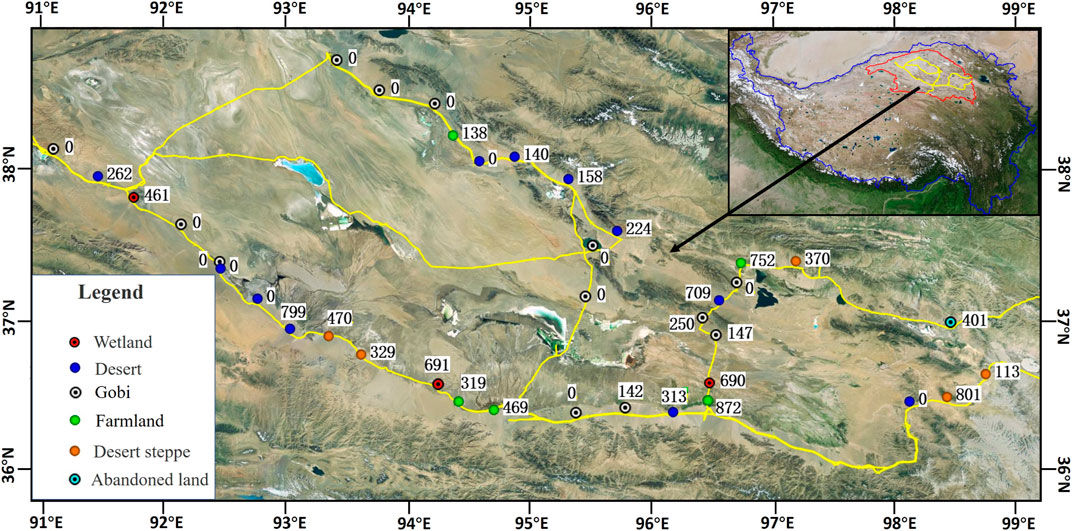
FIGURE 2. Sample locations with measurable 137Cs inventories(Bq m−2).
Higher depletion in the 137Cs inventories and more deposition at some locations were observed. In the western Qaidam Basin, 137Cs inventories was lower limit detection, indicating that there is not sufficient 137Cs content to conduct sediment tracing studies. This finding may be related to the contributions of climatic conditions and potential wind erosion to this radionuclide inventories in soils in the study area. This region is characterized by dryer weather and lower precipitation, which results in limited atmospheric particle settlement. Aoyama et al. (2006) also demonstrated that desert and arid areas in eastern Asia at the same latitude have relatively low 137Cs fallout inputs during the same period. At the same time, rapid aeolian processes are a likely explanation for the presence of low levels of 137Cs. Under the influence of the westerly circulation and the plateau terrain, the annual average wind speed is generally greater than 3 m s−1 in the northwestern Qaidam Basin, with gales (i.e., a wind speed higher than 17 m s−1) occurring more than 50 days annually (Li et al., 2001). The 137Cs-containing materials are gradually blown away under continuous aeolian erosion of the loose and bare soil. These results demonstrate that 137Cs is no longer detectable in this type of environment exposed to very high wind erosion levels. Previous studies of anthropogenic radionuclide deposition revealed that 137Cs deposition occurs via the resuspension of 137Cs-bearing soil particles from remote sources, such as continental soil dust, in the process of wind erosion (Igarashi, et al., 2009; Igarashi et al., 2011; Kha, 2013). However, at desert sites 10 and 29, higher 137Cs inventories of 313 and 799 Bq m−2 were found, respectively, where both sites were characterized by nabkha, which can capture 137Cs dust. The difference between the two sites indicates that the capacity of accumulating 137Cs dust for nabkha decreased when the vegetation degenerated.
The highest 137Cs inventories was found in farmland. Although intense human activities on farmland aggravated wind erosion, which led to more 137Cs loss, an interesting phenomenon occurred in which farmland was the land use type with the highest 137Cs inventories. The inventories at farmland sites 3, 9, 19, 34 and 35 reached values of approximately 1,072, 872, 138, 319 and 469 Bq m−2, respectively. Except for site 34, where 137Cs inventories was lower than that at the wetlands at site 33, the 137Cs inventories was higher than that at neighboring sampling sites. The existence of such high 137Cs inventories may be explained by the following two reasons. First, river-derived radionuclides exert a substantial influence. Accordingly, the radionuclides derived from rivers strongly depend on the amount of radioactive materials deposited in catchment areas by wind and water erosion. Funk R et al. (2012) found that the highest 137Cs inventory was measured in river deposits due to fluvial and aeolian sediments. Reasons for this finding can be partly explained by irrigation contributing to an efficient 137Cs input for farmland. Second, the trees reduce wind speed by serving as a windbreak for farmland, thereby trapping 137Cs-bearing dust and reducing the amount that can be carried away by wind. Although the farmland at sites 34 and 35 were both irrigated, the 137Cs inventories of farmland site 35 was higher than that of farmland site 34, which could be explained by the farmland windbreak reducing farmland soil erosion and even intercepting sandstorms that contain radionuclides. In a similar environmental monitoring study, the closer the farmland windbreak was, the higher the 137Cs inventories in agricultural soil (Su et al., 2021). The study also confirmed that farmland windbreaks induce farmland soil erosion by intercepting sandstorms that contain radionuclides. Therefore, caution should be taken when using 137Cs technology to study wind erosion on farmland.
Low 137Cs inventories was found in the abandoned land at sites 2 and 36, with values of 401 Bq m−2 and lower limit detection, respectively, indicating strong wind erosion before land abandonment. The difference between the two sites can be explained by the fact that site 2 has a longer duration of land abandonment than site 36, which has lost less 137Cs. Concurrently, Rodrigo-Comino et al. (2018) also found that soil erosion rates depend on the duration of land abandonment; soil losses decrease as abandonment duration increases.
In wetlands at sites 8, 25 and 33, 137Cs inventoriesreached values of approximately 690, 461 and 691 Bq m−2, respectively, which were all higher than those at neighboring sampling sites (except for farmland). The plausible explanation is that their relatively high vegetation cover in low-lying wetlands, which can reduce wind erosion and even capture additional deposition of 137Cs-rich dust, caused temporary flooding and additional water erosion deposits in this area. At the same time, the presence of sodium salts and calcium carbonates in the abiotic crust soils on the tops of several centimeters of soil surfaces protects soils against erosion by binding soil particles together, shielding surfaces against abrasion induced by airborne particles, and reducing wind velocity at the soil surface by increasing microtopography (Fattahi et al., 2021).
137Cs was studied in soil samples collected from 39 locations in the Qaidam Basin in 2019 to provide information on the distribution of artificial radionuclides. 137Cs inventories vary greatly from lower limit detection to 1,072 Bq m−2, averaging 266 Bq m−2. Overall, 137Cs inventories shows a decreasing trend from northeast to southwest, which can be attributed to a decrease in rainfall and an increase in wind erosion from east-south to west-north. Gobi has the lowest 137Cs inventories because it has the lowest rainfall deposition and greatest wind erosion. Farmland has the highest 137Cs inventories, which is the result of windbreaks intercepting 137Cs-rich aeolian material, and irrigation input wetlands have relatively high 137Cs inventories because of high vegetation cover, protection of the physical crusts against wind erosion and sediment input.
The raw data supporting the conclusion of this article will be made available by the authors, without undue reservation.
KB: Conceptualization, Data curation, Formal Analysis, Writing–original draft, Writing–review and editing. CW: Conceptualization, Data curation, Formal Analysis, Funding acquisition, Investigation, Methodology, Writing–review and editing. YS: Investigation, Methodology, Supervision, Validation, Writing–review and editing.
The author(s) declare financial support was received for the research, authorship, and/or publication of this article. This research was supported by the Second Tibetan Plateau Scientific Expedition and Research Program (STEP) (Grant No. 2019QZKK0306).
The authors declare that the research was conducted in the absence of any commercial or financial relationships that could be construed as a potential conflict of interest.
All claims expressed in this article are solely those of the authors and do not necessarily represent those of their affiliated organizations, or those of the publisher, the editors and the reviewers. Any product that may be evaluated in this article, or claim that may be made by its manufacturer, is not guaranteed or endorsed by the publisher.
Aoyama, M., Hirose, K., and Igarashi, Y. (2006). Re-construction and updating our understanding on the global weapons tests 137Cs fallout. J. Environ. Monit. 8 (4), 431–438. doi:10.1039/b512601k
Du, S. S., Wu, Y. Q., and Tan, L. H. (2018). Geochemical evidence for the provenance of aeolian deposits in the Qaidam Basin, Tibetan plateau. Aeolian Res. 32, 60–70. doi:10.1016/j.aeolia.2018.01.005
Fattahi, S. M., Soroush, A., Huang, N., Zhang, J., Abbasi, S. J., and Yang, Y. (2021). Durability of biotechnologically induced crusts on sand against wind erosion. J. Arid Environ. 189 (8), 104508. doi:10.1016/j.jaridenv.2021.104508
Funk, R., Yong, L., Hoffmann, C., Reiche, M., Zhang, Z. D., Li, J. J., et al. (2012). Using137Cs to estimate wind erosion and dust deposition on grassland in Inner Mongolia-selection of a reference site and description of the temporal variability. Plant Soil 351 (1-2), 293–307. doi:10.1007/s11104-011-0964-y
Hedvall, R., Erlandsson, B., and Soren, M. (1996). Cs-137 in fuels and ash products from biofuel power plants in Sweden. J. Environ. Radioact. 31 (1), 103–117. doi:10.1016/0265-931X(95)00028-9
Igarashi, Y., Fujiwara, H., and Jugder, D. (2011). Change of the Asian dust source region deduced from the relationship between anthropogenic radionuclides in surface soil and precipitation in Mongolia. Atmos. Chem. Phys. 11 (1), 2843–2011. doi:10.5194/acpd-11-2843-2011
Igarashi, Y., Inomata, Y., Aoyama, M., Hirose, K., Takahashi, H., Shinoda, Y., Sugimoto, N., Shimizu, A., et al. (2009). Possible change in Asian dust source suggested by atmospheric anthropogenic radionuclides during the 2000s. Atmos. Environ. 43 (18), 2971–2980. doi:10.1016/j.atmosenv.2009.02.018
Jiang, Y. S., Gao, Y. H., Dong, Z. B., Liu, B. L., and Zhao, L. (2018). Simulations of wind erosion along the qinghai-tibet railway in northcentral tibet. Aeolian Res. 32, 192–201. doi:10.1016/j.aeolia.2018.03.006
Kha, B. (2013). Temporal variation of monthly 137Cs deposition observed in Japan: effects of the Fukushima Daiichi nuclear power plant accident. Appl. Radiat. Isotopes 81, 325–329. doi:10.1016/j.apradiso.2013.03.076
Li, S., Dong, Y. X., and Dong, G. R. (2001). Sandy desertification problem and sustainable development in qinghai-tibet plateau. Beijing: China Tibetology Publishing House. (in Chinese).
Li, Y., Li, J. J., Are, K. S., Kayode, S. A., Huang, Z. G., Yu, H. Q., et al. (2019). Livestock grazing significantly accelerates soil erosion more than climate change in Qinghai-Tibet Plateau: evidenced from 137Cs and 210Pbex measurements. Agric. Ecosyst. Environ. 285, 106643–106648. doi:10.1016/j.agee.2019.106643
McHenry, J. R., and Ritchie, J. C. (1977). Physical and chemical parameters affecting transport of 137Cs in arid watersheds. Water Resour. Res. 13, 923–927. doi:10.1029/WR013i006p00923
Ritchie, J. C., and McHenry, J. R. (1990). Application of radioactive fallout cesium-137 for measuring soil erosion and sediment accumulation rates and patterns: a review. J. Environ. Qualiry 19, 215–233. doi:10.2134/jeq1990.00472425001900020006x
Ritchie, J. C., Spraberry, J. A., and McHenry, J. R. (1974). Estimating soil erosion from the redistribution of fallout 137Cs. Soil Sci. Soc. Am. Proc. 38, 137–139. doi:10.2136/sssaj1974.03615995003800010042x
Rodrigo-Comino, J., Martínez-Hern´Andez, C., Iserloh, T., and Cerda, A. (2018). Contrasted impact of land abandonment on soil erosion in mediterranean agriculture fields. Pedosphere 28 (4), 617–631. doi:10.1016/S1002-0160(17)60441-7
Su, Z. A., Zhou, T., Zhang, X. B., Wang, X. Y., Wang, J. J., Zhou, M. H., Zhang, J. H., et al. (2021). A preliminary study of the impacts of shelter forest on soil erosion in cultivated land: evidence from integrated 137Cs and 210Pbex measurements. Soil Tillage Res. 206, 104843–104912. doi:10.1016/j.still.2020.104843
Teng, Y. M., Zhan, J. Y., Liu, W., Sun, Y. X., Agyemang, F. B., Liang, L., et al. (2021). Spatiotemporal dynamics and drivers of wind erosion on the Qinghai-Tibet Plateau, China. Ecol. Indic. 123, 107340–107412. doi:10.1016/j.ecolind.2021.107340
Walling, D. E., and He, Q. (1999). Improved models for estimating soil erosion rates from cesium-137 measurements. J. Environ. Qual. 28 (2), 611–622. doi:10.2134/jeq1999.00472425002800020027x
Wang, Y. B., Sun, Y., Niu, F. J., and Wu, Q. B. (2017). Using 137Cs measurements to investigate the impact of soil erosion on soil nutrients in alpine meadows within the yangtze river region, China. Cold Regions Sci. Technol. 135, 28–33. doi:10.1016/j.coldregions.2016.12.008
Yan, P., and Dong, G. R. (2003). Application of the caesium 137Cs technique on wind erosion in the Gonghe basin, Qinghai Province. Acta Pedol. Sin. 40 (4), 497–503.
Yan, P., Dong, G. R., Zhang, X. B., and Zhang, Y. Y. (2000). Preliminary results of the study on wind erosion in Qinghai-Tibet Plateau using 137Cs technique. Chin. Sci. Bull. 45 (2), 199–204. doi:10.1007/BF02884984
Yan, P., Dong, Z. B., Dong, G. R., Zhang, X. B., and Zhang, Y. Y. (2001). Preliminary results of using 137Cs to study wind erosion in the Qinghai-Tibet Plateau. J. Arid Environ. 47 (4), 443–452. doi:10.1006/jare.2000.0749
Zapata, F. (2002). Handbook for the assessment of soil erosion and sedimentation using environmental radio nuclides. Dordrecht: Kluwer Academic Publishers.
Zhang, C. L., Zou, X. Y., Yang, P., Dong, Y. X., Li, S., Wei, X. H., et al. (2007). Wind tunnel test and 137Cs tracing study on wind erosion of several soils in Tibet. Soil Tillage Res. 94 (2), 269–282. doi:10.1016/j.still.2006.08.002
Keywords: Qaidam Basin, cesium-137, farmland, 137Cs inventories, wind erosion
Citation: Bian K, Wang C and Shen Y (2023) 137Cs inventories in soil in the Qaidam Basin, Tibetan Plateau. Front. Environ. Sci. 11:1291707. doi: 10.3389/fenvs.2023.1291707
Received: 10 September 2023; Accepted: 30 October 2023;
Published: 09 November 2023.
Edited by:
Lihai Tan, Chinese Academy of Sciences, ChinaReviewed by:
Jianhua Xiao, Chinese Academy of Sciences, ChinaCopyright © 2023 Bian, Wang and Shen. This is an open-access article distributed under the terms of the Creative Commons Attribution License (CC BY). The use, distribution or reproduction in other forums is permitted, provided the original author(s) and the copyright owner(s) are credited and that the original publication in this journal is cited, in accordance with accepted academic practice. No use, distribution or reproduction is permitted which does not comply with these terms.
*Correspondence: Cuiping Wang, d2FuZ2N1aXBpbmcuNTE4QDE2My5jb20=
Disclaimer: All claims expressed in this article are solely those of the authors and do not necessarily represent those of their affiliated organizations, or those of the publisher, the editors and the reviewers. Any product that may be evaluated in this article or claim that may be made by its manufacturer is not guaranteed or endorsed by the publisher.
Research integrity at Frontiers
Learn more about the work of our research integrity team to safeguard the quality of each article we publish.