 Bao Meng1
 Shaoyao Zhang
 Wei Deng
 Li Peng
- 1Faculty of Economics and Business Administration, Yibin University, Yibin, China
- 2The Faculty Geography Resource Sciences, Sichuan Normal University, Chengdu, China
Objectively evaluating and defining territorial spatial functions are important prerequisites for optimizing the use of territorial space. However, the results of the evaluation of functions at different levels may differ significantly. How to integrate the evaluation results and guide the spatial utilization at different levels more effectively is worth exploring. This study takes as the research area Yibin City, China, a node city along the Yangtze River in the upper reaches of the Yangtze River. In the study, 185 towns in that city were taken as the primary evaluation units for an indicator system of territorial spatial function constructed on the basis of multivariate data. Research methods such as the entropy method and cluster analysis were adopted to do multilevel evaluations and zoning of territorial spatial functions in Yibin City. The results suggest the following: 1) The distribution of agricultural production, rural living, and ecological regulation functions among the second-level production-living-ecological (PLE) functions of townships were relatively balanced in Yibin City. The production function of industry and mining, urban life function, and ecological product supply function showed spatial directivity. 2) The evaluation results of the first-level PLE functions of townships showed that the areas with substantial PLE functions accounted for approximately 20%, whereas the areas with insignificant functions accounted for approximately 80%, which reflected the “80/20 rule” of spatial functions. 3) In accordance with the cluster analysis of the multilevel evaluation results, the township functions in Yibin were divided into 5 functional areas: urban life-industrial production advantage areas (12%), urban life-rural life advantage areas (8%), rural life-agricultural production-ecological function product supply advantage areas (29%), rural life-agricultural production-ecological service function advantage areas (20%), and ecological service function-agricultural production function advantage areas (31%). 4) In the future, Yibin City should focus on 20% of the significant functional areas and attach importance to the relativity of spatial functions to form a high-quality territorial spatial protection and development pattern. Based on the objectives and requirements of the new territorial spatial planning in China, this study reconstructed the municipal territorial spatial functional areas through a multilevel functional evaluation, which has theoretical and practical significance for forming a new pattern of territorial spatial development and use with joint production, living, and ecological functions.
1 Introduction
Since China’s Reform and Opening Up, with the rapid development of industrialization and urbanization, the use pattern of territorial space has been reshaped constantly, and the spatial functions based on spatial patterns have become disordered (Kim and Arnhold, 2018). It is difficult to guarantee a “production-living-ecological” (PLE) functional form and demands, which will greatly restrict regional sustainable development (Cheng et al., 2022; Qiu et al., 2023). Especially in the key river basins (e.g., Yangtze River and Yellow River) of China, the optimization of territorial spatial functions is associated with national ecological security and has been highly valued by the Chinese government in recent years (Xi et al., 2020; Niu et al., 2022). The proposal to promote “well-coordinated environmental conservation and avoid excessive development” in the Yangtze River basin has brought new challenges to the territorial spatial development and functional trade-offs of the basin, especially in the upper reaches of the Yangtze River (Fan et al., 2015; Zhao et al., 2022a). Research on current functional identification and zone optimization might lead to improved policy insights for the best development of watershed territorial space.
According to regional function-structure theory, differences in spatial function are determined by spatial heterogeneity. There are differences in the components or quantity compositions of spatial elements in each region, the effect of natural evolution, and human activities, which result in various spatial patterns (Xie et al., 2021a; Zhao et al., 2022b). The failure of those patterns to adapt to sustainable human development is regarded as spatial dysfunction, which can be balanced by artificial planning constraints (Fu et al., 2021; Zhang, 2022). The evolution of territorial space also follows the general laws of geography: the initial pattern and process determine the pattern and the corresponding functions, while the pattern in turn affects the evolution of the process (Fu, 2002; Brooks and Lee, 2019). After a territorial spatial pattern and its corresponding functions are formed, the pattern will be stable for some time, but the evolution of its driving mechanism and process can be influenced by human planning. That planning will affect the spatial state and quality of the pattern and functions and provide decision-making support for spatial optimization and use (as shown in Figure 1) (Wei et al., 2021; Wang et al., 2022).The spatial scope of various resource allocation and development demands results in no unified model for dividing territorial spatial functions. However, there is a consensus to scientifically define a region’s most appropriate regional function in a specific development stage through evaluation. The function should be conducive to the increase of the sustainability of spatial use and the positive effect (Li et al., 2021a). It should also enable top-down spatial control and formulating a spatial intervention policy (Ma et al., 2022). As a direct basis for the division of territorial spatial functions, evaluating spatial suitability and primary zones is vital. In particular, selecting evaluation units and evaluation perspectives and methods is a focus of research and practice.
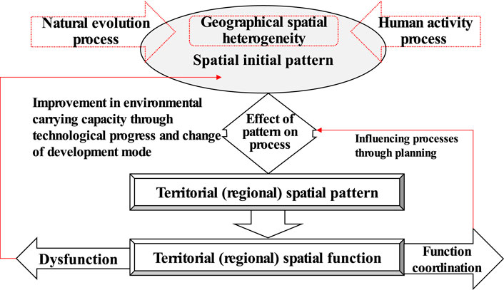
FIGURE 1. Pattern and process of territorial space function.
The main methods for identifying territorial spatial functions are evaluating resources and environmental carrying capacity and determining the suitability of territorial spatial development (referred to as a “double evaluation”) (Wang et al., 2019). Those methods have already been used by the Chinese government, and they provide scientific support for planning China’s “urban-agricultural-ecological” spaces (Hsu et al., 2021). Different from the urban, agricultural, and ecological functions, the current spatial production-living-ecological (PLE) function originated from the agricultural multifunctional classification system of the European Union. Later, with the rise of research on land multifunctionality, the PLE function concept was introduced in land use classification and spatial policies (Callo-Concha and Denich, 2014; Xue et al., 2022). For example, the Chinese government’s PLE space division and development aspirations are expressed as promoting intensive and efficient production spaces, livable and moderate living spaces, and beautiful ecological spaces (Yang et al., 2020).That emphasis at the national strategic level has attracted academic attention, and the comprehensive index of the PLE function has become the basis for spatial function, identification, and comprehensive spatial governance (Xie et al., 2021b; Hou et al., 2022). The current research on evaluating the PLE territorial spatial function is essential to understanding the spatial quantitative structure, function level, and function divisions of territorial space. That includes selecting stable and reasonable spatial evaluation units and establishing an evaluation system and model (Zhang and Xu, 2021; Xiao et al., 2022; Zhang et al., 2022). As for the scale, regional and watershed-level evaluations are based primarily on grid units (30 m × 30 m, 100 m × 100 m, 1,000 m × 1,000 m) or standard evaluation units (nomenclature of territorial units for statistics) (Fu et al., 2022; Liao et al., 2022).Generally, the evaluation results offer little guidance for arranging industrial land use types in a city or for spatial control zoning. Therefore, great importance has been attached to evaluating a county’s territorial spatial function (Li et al., 2021b; Fu and Zhang, 2021). To construct a scientific evaluation model as a breakthrough focus, the evaluations involve using powerful computing hardware, mathematical methods, and 3S technology (geographic information system technology, global positioning system technology, remote sensing technology) (Ling et al., 2022). Data from multiple sources, such as remote sensing images, geographical conditions, and internet points of interest (POI) have also been comprehensively adopted (Han et al., 2019; Li et al., 2022a). For example, the development of a land suitability evaluation model, the Intelligent Geographical Information System (LEIGIS) (Kalogirou, 2002), and a suitability evaluation of a particular type of crop planting area for agriculture (Ostovari et al., 2019). Current research often focuses on a function (life, production, or ecology) as an entry point. Few studies of multifunctional fusion zones based on a dominant function have been done, and evaluating single functions is done at the level of data sources. In practice, that fails to obtain sufficient richnesses of the functional connotation and practical guidance because the evaluation unit cannot match the primary administrative unit (the township). The township is the smallest socio-economic management unit in China, which takes into account the socio-economic unity, the integrity of the natural ecosystem and the scientificity of spatial management. How to scientifically conduct multilevel territorial spatial function evaluation and comprehensive zoning at township scale is a scientific issue worth exploring. For the complexity and evolution of spatial functions, a multilevel evaluation of spatial functions that aligns with the control subject is better adapted to the characteristics of the functional area and more conducive to integrating multiple functions under the dominant function. It is also more conducive to a detailed analysis of evaluation results and to obtaining practical guidance for optimizing territorial spatial development.
Yibin City, in the upper reaches of China’s Yangtze River Economic Belt, was this study’s research area. Considering the administrative subject of spatial control and the scope of the research area, this study adopted 185 townships in Yibin City as the primary evaluation units. In accordance with the spatial and statistical data, the basic concept of PLE space was applied to evaluate the research area’s spatial functions. The evaluation was divided into three levels: a second-level PLE function, a first-level PLE function, and a comprehensive PLE function. The second-level PLE function of a township evaluated the dominant spatial functions of different townships: urban living, rural living, industrial and mining production, agricultural production, ecological regulation, and ecological product supply. Based on the second-level PLE functions of a township, its first-level PLE functions (production, living, and ecological functions) were obtained. Then, based on the evaluation results of spatial functions at various levels and the dominant spatial function, the comprehensive PLE functions area is divided. This study aims to explore the evaluation and comprehensive zoning methods of multi-level spatial functions to define the territorial spatial functions more scientifically, and to understand the territorial spatial functions of townships (the lowest and most direct level of spatial control subjects in the current Chinese system) more objectively in the spatial utilization and management.
2 Study area
Yibin, a city in China’s Sichuan Province, is located in the upper reaches of the Yangtze River, where the Jinsha and Minjiang rivers converge to form the Yangtze River (Figure 2). With an area of 13,283 km2, it covers 3 districts, 7 counties, and 185 townships. By the end of 2018, the registered population of Yibin was 5.523 million, and the permanent population was 4.556 million. The annual GDP of the region was 234.931 billion yuan, and the ratio of the three industrial structures was 12.2:49.7:38.1. Yibin is in the transition zone from the Sichuan Basin to the Yunnan-Guizhou Plateau. That zone is characterized by a transition from low and mild hills to steep hills and low mountains with an altitude of 500–2,000 m and marked differences in territorial spaces. The Jinsha and Minjiang rivers intersect in the central urban area, then become the Yangtze River’s mainstream, traversing central and eastern Yibin from west to east. The spatial functional zone is important because of the influence of the geomorphic pattern, which further affects the use complexity.
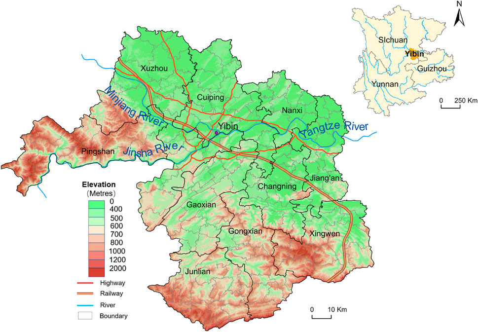
FIGURE 2. Location of Yibin city.
Yibin has entered an accelerated stage of urbanization and industrialization driven by the development of western China and the strong development of its urban economy, the changes in its transport methods (multi-transportation such as water transport and high-speed railway), and its interregional location (central city of southern Sichuan Province).From the perspective of the watershed ecosystem, Yibin City plays a major part in the ecological barrier in the upper reaches of the Yangtze River. Because of the ecological environment protection in the Yangtze River Basin, the territorial spatial function of Yibin City is mainly ecological, which is of great significance for maintaining the ecological security pattern in the upper reaches of the Yangtze River (Li et al., 2022b). As a modern economic location, Yibin is developing into a growth point that extends westward along the Yangtze River Industrial Belt. It is a subcentral city in Sichuan Province and a central city in the southern region of Sichuan Province, whose urban development functions are also important. From the perspective of development status, territorial spatial development is not only extensive; it is also constrained by national and provincial policies such as the grain for green project, transformation development, environmental protection requirements, and ecological environment restoration in the Yangtze River basin. The rapid expansion of urban and industrial land has encroached on cultivated and ecological lands, which changed the original territorial spatial structure and functions and had a marked effect on the sustainable development of the territorial space (Zhou et al., 2017). Therefore, scientifically evaluating and defining territorial spatial functions and guiding the formation of a new pattern of territorial spatial development and use are conducive to offering guidance to the high-quality development of Yibin’s territorial space. They also lay a scientific foundation for constructing and developing the upper reaches of the Yangtze River economic belt.
3 Data and methods
3.1 Data sources
This study’s datasets include spatial, statistical, survey, generated, and report data (Table 1).
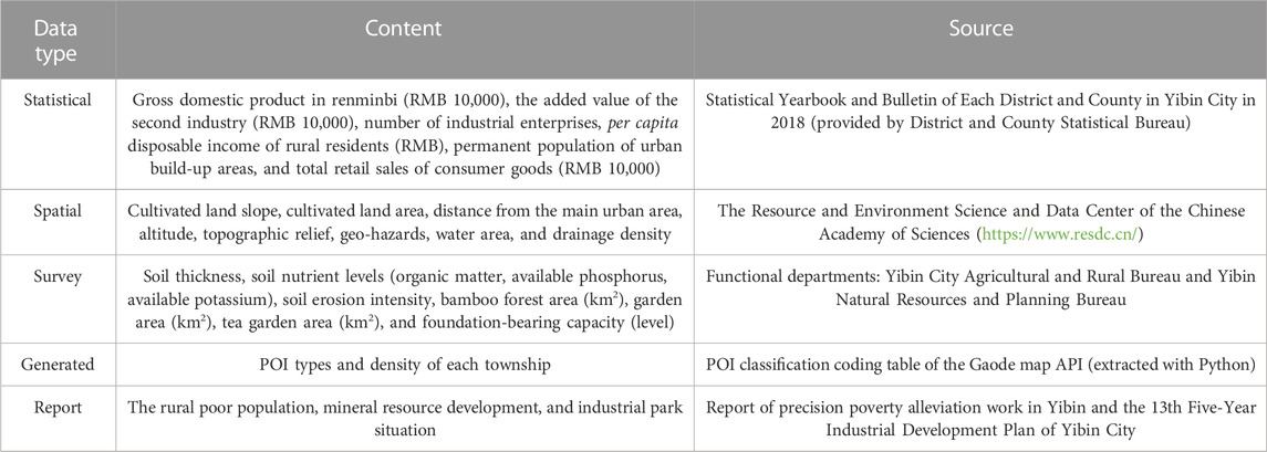
TABLE 1. Research data description.
3.2 Research methods
3.2.1 Construction and description of evaluation indicators
Based on the PLE classification of territorial space, this study’s evaluation divided the production function into agricultural production and industrial and mining production. The living function was divided into rural and urban life, and the ecological function was divided into ecological regulation and product provision, forming a criterion layer. Because the evaluation was based on the township as the primary research unit, the form and content of statistical data items at the township level and statistical yearbooks at the district and county levels were not uniform, and there were differences between the main statistical items, so an attempt was made to adopt the indicator data with unified statistics for each township. Referring to the relevant literature (Yang et al., 2020; Xie et al., 2021b; Wang et al., 2023), taking the actual situation of territorial spatial development and the pertinence, stability, scientificalness, and accessibility of indicators into consideration in Yibin City, the final evaluation index system comprised 3 target layers, 6 criterion layers, and 28 indicator items, as shown in Table 2.
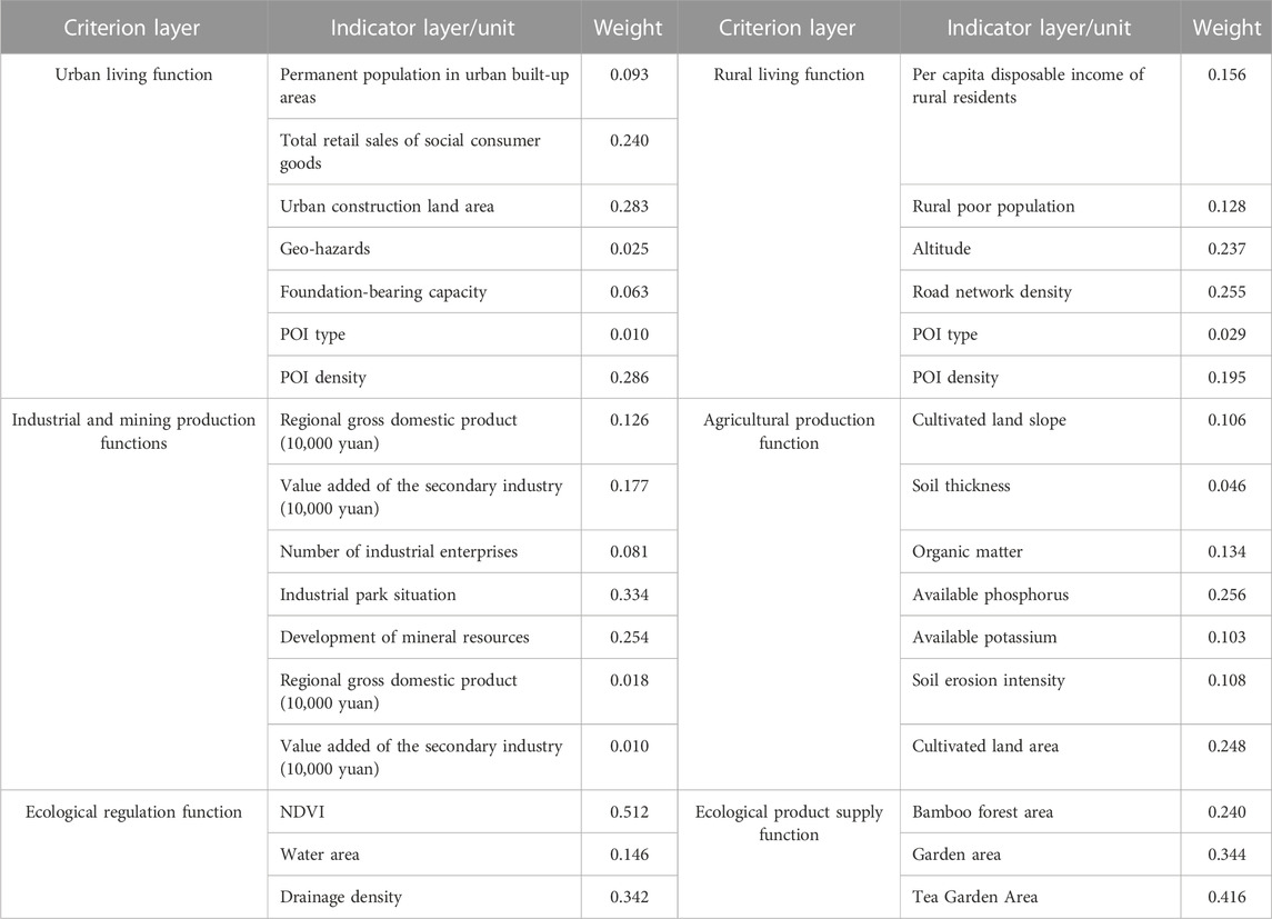
TABLE 2. Function evaluation index system and weight allocation of the current situation of the PLE space in Yibin City.
3.2.1.1 Indicators of the production function
Soil thickness, nutrient level, soil erosion intensity, and cultivated land slope are the key indicators that characterize the geographical conditions of cultivated land and can be used as natural factor conditions for agricultural production functions. The current cultivated land area was the result of the influence of cultivation conditions and cultivation willingness and reflected the foundation of agricultural production functions. Therefore, it was included in the indicator system.
In the industrial and mining production functions, the regional gross domestic product, value added by secondary industries, and the number of industrial enterprises can effectively represent the current regional industrial development. (The secondary industries’ added value was chosen as a factor because the industries contribute much to the regional gross domestic product in Yibin City.)The parks included industrial parks, agricultural industrial parks, and comprehensive industrial parks (e.g., logistics and specialty commerce), which were assigned values based on their quantity and scale. The assigned values for the planned parks were halved.
The reason for adding the terrain undulation is that Yibin City is a low-mountain and hilly area with few flat land resources, whereas the areas with minor terrain undulations and abundant flat land resources can provide alternative land for industrial and mining layouts.
3.2.1.2 Indicators of living function
The rural residents’ per capita disposable income and the impoverished population in rural areas were important current indicators of rural living functions. Although at the time of the study Yibin City had no absolute poverty, it aimed to help people out of poverty. Therefore, the number of poor people at the beginning of targeted poverty alleviation reflected the overall rural human settlements and living conditions to some extent. Altitude and traffic accessibility, which directly affect the environment and conditions of rural entrepreneurship, had an important effect on the return of rural youth laborers and was adopted to be an important indicator for evaluating the rural living function.
As for the urban living functions, the permanent population of the built-up area and the total retail sales of social consumer goods effectively represented the current urban living situation. Geo-hazards and foundation-bearing capacity were included in the index system, which focused on the deep dependence of high-density living facilities on urban environments.
3.2.1.3 Indicators of ecological function
The ecological product supply function was evaluated based on the advantageous tea and bamboo industries in Yibin City (the capital of bamboo in China and the famous hometown of tea in early China). Bamboo forest, garden, and tea garden areas were taken as evaluation criteria.
3.2.2 Comparative advantage index
The first step was to build the original matrix of indicator based on the indicator system. The second step was normalizing the original matrix to obtain a new one. During that process, attention was paid to the distinction between positive and negative indicators. The third step was calculating the entropy and weight of the functional area indicators by the entropy weight method. The specific weights of each indicator are shown in Table 2. To better understand the patterns and statuses of the PLE functions of townships at the municipal level, the normalized revealed comparative advantage index (
where
3.2.3 Ward system clustering method
The ward system clustering method used the sum of squared deviations to calculate the distance. The sum of square Euclidean distances from each element in a class to the class center of gravity (i.e., the class mean) is called the sum of squared deviations in a class. Assuming that
Assuming that when
It can be seen that the ward-clustering analysis applied the analysis of variance to classification, making the sum of squares of deviation in the same category small, which suggested the high similarity between samples. If the sum of squares of deviations between different classes were large, the similarity between samples would be low. By studying the first-level territorial spatial classification of PLE values as the clustering analysis factors, the comprehensive spatial clustering analysis results of PLE space at the township level in Yibin City were obtained through ward system clustering.
4 Results and analysis
Based on the total scores of different functional properties of each township calculated by the methods mentioned above, they were divided into 4 levels with natural breaks: high-value area, higher-value area, lower-value area, and low-value area. The visualization display and analysis follow.
4.1 Classification and evaluation of second-level functions of PLE space
The evaluation results of urban and rural living functions at the township level in Yibin are shown in Figure 3. Six townships were in high-value areas of urban living functions, 16 townships were in higher-value areas, 124 townships were in lower-value areas, and 39 townships were in low-value areas. The proportions of high, higher, lower, and low-value areas in the study area were 3%, 8%, 71%, and 18% respectively. The proportions of townships with high, higher, lower, and low value living functions in rural areas were 41, 84, 49, and 11 respectively, accounting for 15%, 46%, 30%, and 9% of the study area respectively. From the perspective of the living functions in the city, most areas were mainly rural living functions; the areas with high and higher urban living functions accounted for only 11%.
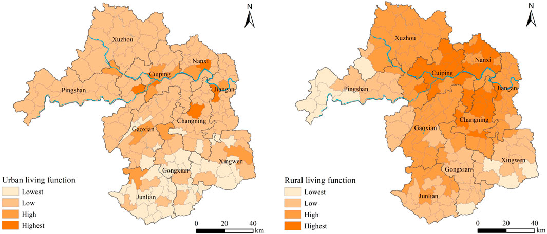
FIGURE 3. Urban living and rural living function zones of townships in Yibin.
From the perspective of distribution, the townships with a high value for urban living functions in Yibin were distributed mainly in the central urban areas along the Yangtze River, including the current streets in Cuiping District, Baixi Town in Xuzhou District, Nanxi Street in Nanxi District, and Jiang’an Town in Jiang’an County. In addition, it included Xunchang Town and Changning Town. The towns with higher value were mainly the central towns of the district and county, whereas townships with a low urban living function were distributed mainly in the southern part of middle- and low-mountain counties such as Xingwen County, Changning County, Gong County, and Junlian. The areas with high value for rural living functions in Yibin included Cuiping District, Nanxi District, and most northern townships in Changning County. The areas with higher value were mainly the townships in Xuzhou District, Jiangan County, and Gao County, and the areas with low value included the townships in the western part of Pingshan County and three Miao townships in the southern part of Xingwen County. The areas with high value for urban and rural living functions reflected the characteristics of concentrated distribution along the Yangtze River. Because of many flat dams along the river, intensive production factors, and earlier development history driven by the advantages of water transportation, it became the first choice for the layout of living areas. In mountainous and hilly areas with little flat land, the shoreline areas along the river that were unaffected by floods greatly attracted urban and rural residents.
The evaluation results of the production function of each township’s industrial and mining industry are shown in Figure 4. The numbers of townships with high-value, higher-value, lower-value, and low-value industrial and mining production functions were 22, 19, 14, and 130 respectively, accounting for 13%, 11%, 9%, and 67% of the study area respectively. The distribution of high-value areas with Yibin industrial and mining production functions had two basic characteristics: First, they were distributed in the central towns where the district and county governments were. There were convenient transportation and infrastructures in those towns, which were located near government departments, making it easy to lay out the industrial parks or industrial development concentration areas. Second, they were distributed in some townships with resource advantages. For example, Guhe Town in Changning County, Didong Town and Luodu Miao Township in Gong County, and Mu’ai Town in Junlian played an important part in shale gas development. However, such a phenomenon is not consistent. For example, although Qingping Yi Township in Pingshan County had mineral resources like basalt, it was in the safety zone of Xiangjiaba hydropower station, where mining was prohibited. Therefore, it was a low-value township with industrial and mining production functions.
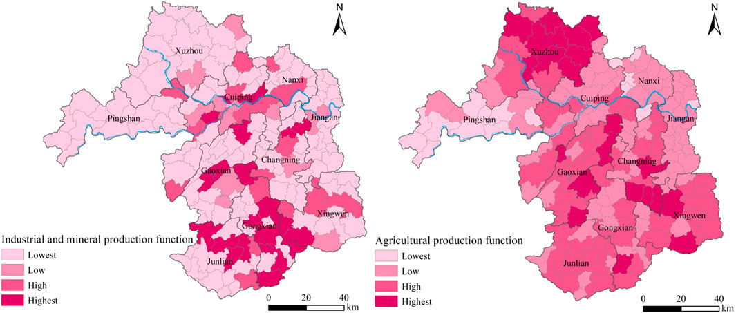
FIGURE 4. Industrial and mineral production function and agricultural production function zones.
The number of townships with high, higher, lower, and low agricultural production functions was 21, 64, 81, and 19 respectively, accounting for 19%, 36%, 36%, and 9% of the study area respectively. It can be seen that the towns with a high value of agricultural production function in Yibin were distributed mainly in Xuzhou District. Some townships were located mainly in the northern part of Xuzhou District, e.g., Liujia Town and Guluo Town. The higher-value areas were distributed in Shengtian Town in Gao County, Zhuhai Town in Changning County, and Bowangshan Town in Xingwen County. From a geomorphologic perspective, those areas were composed mainly of low and gentle hills, not along the river or in the middle and low mountains. The agricultural production functions were dominant because they were under little pressure from urban and ecological spaces. Townships unsuitable for agricultural production were distributed mainly in the central and western parts of Pingshan County. The evaluation results of the built-up area in Cuiping District were also suitable; they were affected mainly by the natural basement conditions. From a practical perspective, most of those areas were urban built-up areas, and although there were good functional conditions for developing agriculture, they were forced to give in to the industrial and urban areas.
As shown in Figure 5, the numbers of townships with high, higher, lower, and low ecological regulation functions were 38, 89, 51, and 7 respectively, accounting for 23%, 47%, 29%, and 1% of the study area respectively. High-functional and higher-value areas accounted for 60%, and lower and low-value areas accounted for 40%. The numbers of townships with high-value, higher-value, lower-value, and low-value ecological product supply functions were 19, 36, 53, and 77 respectively, accounting for 16%, 24%, 29%, and 31% respectively. The proportion of functional high and higher-value areas was 40%, and the proportion of lower and low-value areas was 60%, which was opposite to the proportion of ecological regulation functions. That suggested that 60% of the city area in Yibin currently had good ecological regulation functions. Considering the overlap of the two, approximately 40%–50% of that 60% of townships had favorable ecological regulations and ecological product supply; for example, the resources of camphor trees and bamboo forests had dual ecological functions.
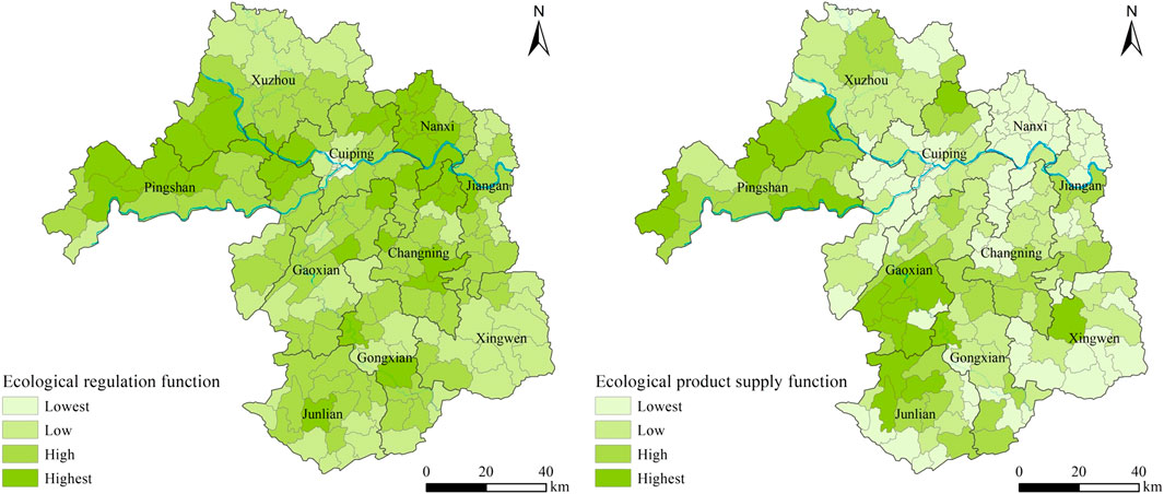
FIGURE 5. Ecological regulation function and evaluation zones of ecological product supply function townships in Yibin.
From the distribution perspective, the ecological regulation function was evenly distributed in the city. Except for the old central urban area where the three rivers join, the high-value areas of ecological regulation functions were mainly middle- and low-mountain areas such as Pingshan, Gao, and Junlian counties. The low and gentle hills in the northern part of Nanxi District were also high-value areas of the ecological regulation function. The townships with the highest ecological supply capacities were mainly the villages along the Jinsha River in Pingshan County, the northern towns, the southern towns such as Qingfu Town in Gao County, and several townships in Junlian and Xingwen County. The features common to those towns were the wide distribution of bamboo forests and tea gardens, the low level of industrialization and urbanization, and the outstanding ecological background. The distribution of areas with low ecological supply functions was mainly in the regions along the Yangtze River of Xuzhou District, the Nanxi District, and to the north of Jiang’an County.
4.2 First-level function evaluation of PLE space
The territorial spatial function of a township has a complex nature. Although a township’s second-level territorial spatial function has the characteristic of spatial heterogeneity, their functions are diversified and coexisting in some extent. To better express a township’s comprehensive functions at the territorial PLE space level, 6 second-level functional indicators of a territorial PLE space were used to evaluate its first-level PLE function.
The numbers of townships with high value, higher value, lower value, and low values of first-level living functions (Figure 6) were 9, 14, 100, and 62 respectively. The proportion of townships with higher and high values was 13%, and the proportion with lower and low values was 87%. The area proportions of high, higher, lower, and low-value areas in the city area were 5%, 11%, 58%, and 26% respectively. The areas of higher and high-value townships accounted for 16%, and the areas of lower and low-value townships accounted for 74%. The high-value areas were almost consistent with the current central urban area and the central town where the district and county governments were. The low-value areas with first-level living functions included mainly the townships in Pingshan County and most towns in the southern part of the city. Some of the townships in mosaic shapes, such as Yachi Township, Majia Township, Furong Town, Dongdi Town, and other low-living function areas, might have been related to the selection of indicators and the calculation of specific indices. From the evaluation perspective, the high-value function areas were not absolute, especially the townships that were administrative units whose boundaries were unstable and easily affected by external factors; for example, the trunk roads (highway or industrial park construction). They neither weakened nor enhanced the functional differences between adjacent administrative districts.
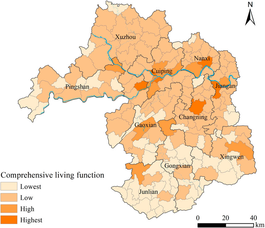
FIGURE 6. First level of living function zones of townships in Yibin.
The numbers of townships with high, higher, lower, and low first-level production functions (Figure 7) were 16, 24, 26, and 119 respectively. Townships with higher and high values accounted for 22%, and townships with lower and low values accounted for 78%, which was almost the same as the numbers and proportions of townships with industrial and mining production functions. The area proportions of high, higher, lower, and low-value areas in the city area were 9%, 14%, 16%, and 61% respectively. The areas of higher and high-value townships accounted for 23%, and the areas of lower and low-value townships accounted for 77%. Their distribution was highly similar to the overall pattern of industrial and mining production functions (Figure 4). That was because the general level of the current agricultural development was not high, but in a low-level equilibrium state in Yibin City. However, because industry greatly relied on transportation, location, and natural resource endowment, there were marked regional differences in industrial and mining production functions. Therefore, the spatial difference distribution of first-level production functions was similar to that of industrial and mining production functions.
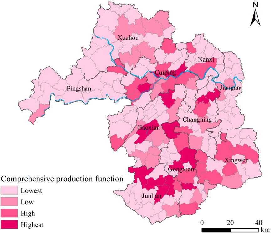
FIGURE 7. First-level production function zones of townships in Yibin.
The numbers of townships with high, higher, lower, and low first-level ecological functions (Figure 8) were 11, 31, 49, and 94 respectively. The proportion of townships with higher and high values was 23%, and the proportion with lower and low values was 77%. The area proportions of the city’s high-, higher-, lower-, and low-value areas were 8%, 20%, 27%, and 45% respectively. The areas of higher and high-value townships accounted for 28%, and the areas of lower- and low-value townships accounted for 72%. The first-level ecological function patterns of the townships in Figure 8 were similar to the ecological product supply function of the townships in Figure 5, which suggests that the ecological service function was relatively balanced in the cities like Yibin with a good ecological foundation. In the future, the ecological supply should be given priority in future ecological civilization construction: it should not only meet the essential ecological services and generate pure ecological benefits but also provide ecological products and bring corresponding economic benefits. Because of the comprehensive value of the ecological effect, the ecological function of territorial space becomes an important direction and approach to optimize the use of territorial space.
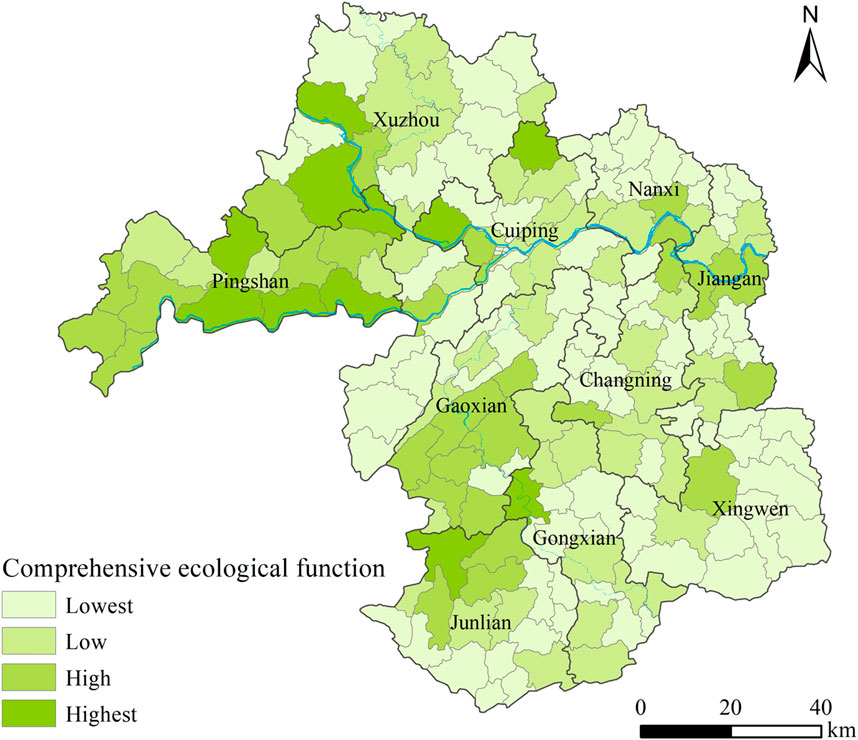
FIGURE 8. First-level ecological function zones of townships in Yibin.
4.3 Zone and development guidance for a comprehensive PLE function
Based on the evaluation of the PLE function of basic spatial units in townships, the ward system clustering method was adopted to obtain the zone result of a comprehensive PLE function of the territorial space in Yibin City (Figure 9). That space was divided into 5 comprehensive PLE function areas: urban life-industrial production advantage, urban life-rural life advantage, rural life-agricultural production-ecological function product supply advantage, rural life-agricultural production-ecological service function advantage, and ecological service function-agricultural production function advantage.
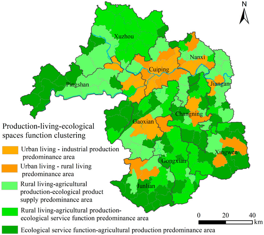
FIGURE 9. Comprehensive PLE space function clustering results of townships in Yibin.
Twenty-three townships were in the urban life-industrial production advantage area, accounting for 12.04% of the total townships and 9.25% of the area. That functional area combined urban life and industrial production functions, focusing on centralized urban construction and developing green industries with low environmental friendliness. The area included mainly streets and townships where the central cities along the river were located. Note that Pu’an, Gaodian, and Xijie towns and Liangjiang Township were classified into this category but not as a direct result of clustering. Instead, they were appropriately revised based on the current planning of urban expansion and industrial concentration areas in Yibin City. The current planning had included them in the central urban expansion area or key industrial parks.
An urban life-rural life advantage area focuses mainly on urban living space and also serves as a rural living space. An urban and rural life advantage zone is an area that focuses mainly on urban and rural living spaces. Its distribution is characterized by being geographically close to the central city (e.g., Nanguang and Lizhuang towns) or being far away from the central city. However, other areas belonged in this category, including a total of 14 townships in the city with prominent central characteristics, long development histories, and vast rural hinterlands (e.g., Junlian and Gusong towns), or towns where important tourist attractions were located (for example, Zhuhai and Shihai towns). They accounted for 8% of the total townships and 8.81% of the area.
A rural life-agricultural production-ecological function product supply advantage area is a township comprising mainly rural life, agriculture, or other business forms around the extension of a modern agricultural industry chain as the leading industry and values the development of ecological agriculture. Although those townships are dominated by rural life and agricultural production, they attach great importance to developing beautiful new villages and the economic benefits of ecological construction driven by a rural revitalization strategy. Such strategies include improving the quality of the ecological product supply of bamboo food, high-quality early tea, and ecotourism. Fifty-three townships were in this area, accounting for 29% of the total townships and 31.14% of the area.
A rural life-agricultural production-ecological service functional advantage area is similar to a rural life-agricultural production-ecological function product supply advantage area, but the former attaches greater importance to ecological service benefits than the latter. That type of area covered 37 townships, accounting for 20% of the total number and 22.55% of the area.
An ecological service function-agricultural production function advantage area puts the achievement of ecological service functions as the top priority and has a scale of agricultural production functions. From a distribution perspective, that area was located in the city’s southern, western, and northern parts because they were mainly mountainous and hilly. Such areas covered 58 townships, accounting for 31% of the total number and 25.46% of the area.
5 Discussion
5.1 The 80/20 rule of space: occasional or objective?
Taking 2018 as the evaluation base year and townships as the primary evaluation unit, this study evaluated the territorial spatial function of Yibin City at 3 levels This study put forward a multi-level territorial spatial function evaluation and comprehensive zoning method, which had important guiding significance for coordinating the territorial spatial function of Yibin City and scientifically carrying out the protection, development and utilization of territorial space. The evaluation results showed an important phenomenon: from the perspective of the comprehensive PLE functions, the towns with higher values and high values and the towns with lower values and low values showed a 2:8 distribution pattern (Table 3).
TABLE 3. Area proportion of various functional areas in the evaluation results of the PLE function.
In other words, the territorial space with important functions in the PLE function accounted for approximately 20% and insignificant functions approximately 80%. Because the 80/20 rule is usually used in social and economic fields, further research is required to determine whether that phenomenon existed in the objective regional space or was an occasional or universal phenomenon. However, the present research partially characterized that phenomenon. For example, an evaluation of the environmental function in Guangxi showed that the high and higher development and construction areas in Guangxi accounted for 15% of the total area of the autonomous region (Bu et al., 2018). Another emulation measured the suitability of the PLE function in the Bailong River Basin, Gansu Province, and showed that the area of highly suitable and appropriate production functions in the basin accounted for 28.78% of the available space (Liu et al., 2019). This may prove the rationality of the territorial spatial function zoning results in this study to some extent. But how to understand and deal with the contradiction of spatial functions at different levels? The 80/20 rule of territorial spatial function demonstrates that, for a particular type of function, whether it is developing, protecting, or optimizing, more than 20% of the functional areas should be focused on, the input-output ratio of space should be improved, space use efficiency should be increased, space governance should be improved, and regional social and economic development should be served. For example, the current Chinese government’s guarantee of functional areas for grain planting should make good use of 20% of the plains areas rather than take mountainous and hilly areas as the key areas for grain planting.
5.2 Relativity of spatial functions
The comprehensive zoning results of PLE function are the result of comprehensive clustering based on the first-level PLE functions, reflecting the commonality of spatial functions and development directions among regions and playing a macro-guiding role for regional development. Therefore, the comprehensive partition results have important reference significance for the gradual optimization of the current function. Note that this study’s evaluation of the PLE function was based on social economic indicators and few natural background indicators, with administrative regions (townships) as the primary evaluation unit. The township boundaries were unstable, and major adjustments of townships at the county level in Sichuan have increased in recent years. However, the evaluation results can be used only as a reference for gradually optimizing the current functional areas. Also, the current functional status is often the result of the joint action of spatial base conditions, the historical inertia of development, and the selection of practical development requirements, which have a strong current situational and developmental selectivity. As the lowest and most direct level of spatial control subjects in the current Chinese system, townships will further explore the functional orientation more in line with their own development on the basis of the comprehensive PLE function zoning results according to their development reality.
According to the evaluation results, Shaping Street belonged to the urban life-industrial production advantage area. As for the current situation, it was the core area for urban spatial expansion in Yibin City. However, before 2009, Shaping Street belonged to a typical agricultural area along the river. The agriculture was mainly rice planting, characteristic breeding (for example, chickens and ducks), and characteristic fruit (for example, kiwi, honey pomelo, and citrus) planting. With the vigorous development of the port economy in Yibin City, that area has been transformed from the original agricultural space to urban and industrial production spaces. Also, the living space has been changed from decentralized rural dominance to compact urban dominance. The area of the production space has expanded and increased gradually, and the ecological space has been compressed and divided into an isolated-island distribution (Figure 10). In accordance with the planning, that area will become the core area of the Sanjiang New District, the first provincial-level new district in Sichuan Province. Therefore, the built-up area will be further expanded, and the breakthrough of function definitions will continue to iterate: rural life-agricultural production-ecological functional product supply advantage area → urban life-industrial production advantage area → High-quality urban living space and strategic emerging industry demonstration area. Although the spatial function is relative, for the special ecological sensitive area of the upper reaches of the Yangtze River, the cities along the river should strictly abide by the ecological bottom line in the process of expansion. Some riverside shorelines and wetlands should ensure the absoluteness of their functions to curb the degradation trend of their ecological functions.
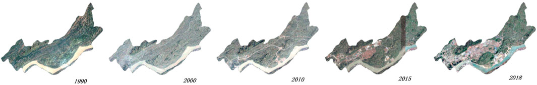
FIGURE 10. High-resolution image of Shaping Street from 1990 to 2018.
5.3 Conservation and development
Coordinating the relationship between territorial spatial conservation and development and optimizing its pattern are important parts in achieving the construction of ecological civilization. The limited spatial resources and the multi-suitability of spatial functions will lead to conflicts between spatial functions, directly affecting the sustainable regional development (Zou et al., 2019). However, how to coordinate and optimize the various territorial spatial functions, alleviate functional conflicts, and realize the high-quality development of the territorial space is an issue that must be paid attention to in the regional territorial spatial protection and development.
Ecological security is the most important reflection of national strategy in the upper reaches of the Yangtze River economic belt. Therefore, at the national level, it is first necessary to satisfy ecological functions such as ecological barrier construction, soil and water conservation, water conservation, aquatic organism protection, water security in the basin, and coastal spatial protection. Of course, that economic belt is also expected to achieve regional economic and social development while fulfilling ecological functions and considering food security and overall basin development (Qian, 2021; Liu et al., 2023). However, local governments such as in Yibin City should focus on how to increase regional development, how to achieve leapfrog development by actively connecting with major national and provincial strategies, and how to increase new industrial economic growth points by doing an industrial transfer, which will help to improve quality and compete for position. Different perspectives on national and regional development lead to different trends in spatial use: conservation demands at the national level require maintaining ecological functions, which might lead to the compression of current production and living spaces in the region. The development demands at the local level drive the continuous expansion of urban and industrial areas, causing an increase in nonagricultural production space, a transformation of traditional agricultural spatial development models and landscapes, and the pursuit of a diversified output of ecological spaces. Therefore, investigating and tackling the relation between development and protection play a key role in the spatial function of that region. For example, great importance should be attached to a more scientific understanding and positioning of ecological functions, the combination of elastic and rigid management, and the integrated development and protection of watersheds. In the future, the maintenance of the spatial function in the upper reaches of the Yangtze River should not only guarantee the reasonable spatial scope, but also pay more attention to the evaluation of the spatial function efficiency, so as to alleviate the direct functional conflicts and coordinate the relationship between protection and development.
6 Conclusion
This By taking 185 townships in Yibin City as evaluation units, this study adopted multivariate data to evaluate the PLE function of Yibin City in 2018 from 3 levels. The results show that:
(1) For the second-level PLE space of the townships in Yibin City, the high-value areas for urban and rural living functions reflected the characteristics of a concentrated distribution along the Yangtze River. The characteristics of the concentrated distribution of high-value industrial and mining production areas were the distribution around the central townships where the district and county government were located and the concentrated distribution of some townships with mineral resource advantages. High-value areas for agricultural production functions were distributed mainly in shallow-hill and flat areas with better light, heat, and water resources in the northern part of the city. The ecological regulation functional areas were evenly distributed throughout the city. The high-value areas of the ecological product supply function were distributed mainly in areas with dense ecological resources such as tea, camphor trees, and bamboo forests.
(2) The distribution of high-value areas for the first-level PLE spatial function of the townships in Yibin City was as follows: high-value areas with first-level living functions were basically consistent with the current central urban areas and central towns where the governments of each district and county were located. The overall pattern of the first-level production function was very similar to that of the industrial and mining production function. The major functional areas were distributed mainly in some central townships with resource advantages. The distribution of first-level ecological functions was similar to the pattern of ecological product supply in various townships, and the major functional areas covered a larger area of bamboo forests and tea gardens in Yibin City.
(3) As for the characteristics of the 80/20 rule of the proportion of significant and insignificant areas in the comprehensive PLE function in the townships, the significant areas accounted for approximately 20%, whereas the insignificant areas accounted for approximately 80%. By applying a cluster analysis to the evaluation results, the functions of townships in Yibin City were divided into 5 types of comprehensive PLE function areas: urban life-industrial production advantage (12%), urban life-rural life advantage (8%), rural life-agricultural production-ecological function product supply advantage (29%), rural life-agricultural production-ecological service function advantage (20%), and ecological service function-agricultural production function advantage (31%). The 5 types of functional areas showed important spatial differences.
In addition to multiple data sources and multilevel function evaluations, importance should be attached to how to use the functional effects of a particular type of functional advantage area and reduce the pressure of multifunctional and functional integration in disadvantaged areas. Moreover, the evaluation of territorial spatial functions is a dynamic process, and conventional function evaluation mechanisms should be explored in the future.
Data availability statement
Publicly available datasets were analyzed in this study. This data can be found here: https://www.resdc.cn/.
Author contributions
BM: Conceptualization, Formal Analysis, Investigation, Methodology, Software, Writing–original draft. SZ: Methodology, Software, Visualization, Writing–review and editing. WD: Conceptualization, Funding acquisition, Supervision, Validation, Writing–review and editing. LP: Conceptualization, Data curation, Project administration, Supervision, Validation, Writing–review and editing.
Funding
The author(s) declare financial support was received for the research, authorship, and/or publication of this article. This research was funded by the high-level talent “QiHang” program of Yibin University (No. 2021QH037), the National Natural Science Foundation of China (Nos: 41930651 and 42101244) and the program of Sichuan Center for Rural Development Research of Sichuan Agricultural University (No. CR2113).
Conflict of interest
The authors declare that the research was conducted in the absence of any commercial or financial relationships that could be construed as a potential conflict of interest.
Publisher’s note
All claims expressed in this article are solely those of the authors and do not necessarily represent those of their affiliated organizations, or those of the publisher, the editors and the reviewers. Any product that may be evaluated in this article, or claim that may be made by its manufacturer, is not guaranteed or endorsed by the publisher.
References
Brooks, B. G. J., and Lee, D. C. (2019). Feasibility of pattern type classification for landscape patterns using the ag-curve. Landsc. Ecol. 34, 2149–2157. doi:10.1007/s10980-019-00869-w
Bu, X. Q., Luo, R. T., Zhao, H. J., Ma, W. C., and Zeng, G. Q. (2018). A study on the comprehensive assessment of environmental function and its spatial differentiation in Guangxi. J. Fudan Univ. Nat. Sci. 57, 68–78.
Callo-Concha, D., and Denich, M. (2014). A participatory framework to assess multifunctional land-use systems with multicriteria and multivariate analyses: a case study on agrobiodiversity of agroforestry systems in Tomé Açú, Brazil. Change Adapt. Socio-Ecological Syst. 1, 40–50. doi:10.2478/cass-2014-0005
Cheng, Z. L., Zhang, Y. J., Wang, L. Z., Wei, L. Y., and Wu, X. Y. (2022). An analysis of land-use conflict potential based on the perspective of production–living–ecological function. Sustainability 14, 5936. doi:10.3390/su14105936
Fan, J., Wang, Y. F., Chen, D., Zhou, C. H., Ma, J. H., Yafei, W., et al. (2015). Analysis on the spatial development structure of the yangtze River Economic belt. Prog. Geogr. 34, 1336–1344. doi:10.18306/dlkxjz.2015.11.001
Fu, B. J. (2002). Ecological and environmental effects of land-use changes in the Loess Plateau of China. J. Chin. Sci. Bull. 67, 3769–3779. doi:10.1360/tb-2022-0543
Fu, J. C., and Zhang, S. L. (2021). Functional assessment and coordination characteristics of production, living, ecological function—a case study of Henan province, China. Int. J. Environ. Res. Public Health 18, 8051. doi:10.3390/ijerph18158051
Fu, J. Y., Bu, Z. Q., Jiang, D., Lin, G., and Li, X. (2022). Sustainable land use diagnosis based on the perspective of production-living-ecological spaces in China. Land Use Pol. 122, 106386–6386. doi:10.1016/j.landusepol.2022.106386
Fu, X. X., Wang, X. F., Zhou, J. T., and Ma, J. H. (2021). Optimizing the production-living-ecological space for reducing the ecosystem services deficit. Land 10, 1001. doi:10.3390/land10101001
Han, Q., Sun, Z. Y., Sun, C. M., Li, D., and Liu, Y. P. (2019). Establishment and application of one map of current situation of territorial spatial planning according to the foundations of natural resources: taking Qingdao city as an example. J. Nat. Resour. 34, 2150–2162. doi:10.31497/zrzyxb.20191011
Hou, Y. Z., Zhang, Z. L., Wang, Y. R., Sun, H. H., and Xu, C. (2022). Function evaluation and coordination analysis of production–living–ecological space based on the perspective of type-intensity-connection: a case study of suzhou, China. Land 11, 1954. doi:10.3390/land11111954
Hsu, W. L., Shen, X. J., Xu, H. Y., Zhang, C. M., Liu, H. L., and Shiau, Y. C. (2021). Integrated evaluations of resource and environment carrying capacity of the Huaihe river ecological and economic belt in China. Land 10, 1168. doi:10.3390/land10111168
Kalogirou, S. (2002). Expert systems and GIS: an application of land suitability evaluation. Environ. Urban Syst. 26, 89–112. doi:10.1016/S0198-9715(01)00031-X
Kim, I., and Arnhold, S. (2018). Mapping environmental land use conflict potentials and ecosystem services in agricultural watersheds. Sci. Total Environ. 630, 827–838. doi:10.1016/j.scitotenv.2018.02.176
Li, S. N., Lv, X., Yin, R., Fang, B., and Jin, T. (2021b). Spatial equilibrium state and its time evolution of the multi-functionalization of regional landuse in the eastern China. Pol. J. Environ. Stud. 30, 2827–2841. doi:10.15244/pjoes/128538
Li, S. N., Zhao, X. Q., Pu, J. W., Miao, P. P., Wang, Q., and Tan, K. (2021a). Optimize and control territorial spatial functional areas to improve the ecological stability and total environment in karst areas of Southwest China. Land Use Pol. 100, 104940–4940. doi:10.1016/j.landusepol.2020.104940
Li, W. J., Fu, J., Jiang, D., Lin, G., and Cao, C. (2022a). Land use optimization in Ningbo City with a coupled GA and PLUS model. J. Clean. Prod. 375, 134004. doi:10.1016/j.jclepro.2022.134004
Li, W. J., Wu, J. P., Du, H. B., Wan, Y., Yang, S. F., Xiao, Y., et al. (2022b). Impact assessment of waterway development on the socioeconomic conditions and ecosystem in the upper Yangtze River. River Res. Appl. 38, 988–999. doi:10.1002/rra.3955
Liao, G. T., He, P., Gao, X. S., Lin, Z. Y., Huang, C. Y., Zhou, W., et al. (2022). Land use optimization of rural production–living–ecological space at different scales based on the BP–ANN and clues models. Ecol. Indic. 137, 108710. doi:10.1016/j.ecolind.2022.108710
Ling, Z. Y., Jiang, W. G., Liao, C. M., Li, Y. S., Ling, Y. R., Peng, K. F., et al. (2022). Evaluation of production–living–ecological functions in support of SDG target 11.a: case study of the Guangxi beibu gulf urban agglomeration, China. Diversity 14, 469. doi:10.3390/d14060469
Liu, D. Q., Zhang, J. X., Gong, J., and Cao, E. J. (2019). Ecological function zoning in Bailongjiang Watershed of Gansu based on production living-ecological function clusters. Chin. J. Ecol. 38, 1258–1266.
Liu, X. Q., Wang, X., Chen, K. L., and Li, D. (2023). Simulation and prediction of multi-scenario evolution of ecological space based on flus model: a case study of the yangtze river economic belt, China. J. Geogr. Sci. 33, 373–391. doi:10.1007/s11442-023-2087-9
Ma, Y., Xue, F., and Yang, Z. (2022). Coupling study on territory space suitability evaluation and construction land expansion simulation: a case study of Jiangxi province, China. Environ. Dev. Sustain. 25 (8), 8279–8298. doi:10.1007/s10668-022-02399-z
Niu, G. Y., Wang, G. L., Lu, Q. C., and Xiong, C. H. (2022). Function evaluation and optimal strategies of three types of space in cross-provincial areas from the perspective of high-quality development: a case study of Yangtze River delta, China. Pol. J. Environ. Stud. 3, 2763–2777. doi:10.15244/pjoes/144910
Ostovari, Y., Honarbakhsh, A., Sangoony, H., Zolfaghari, F., Maleki, K., and Ingram, B. (2019). GIS and multi-criteria decision-making analysis assessment of land suitability for rapeseed farming in calcareous soils of semi-arid regions. Ecol. Indic. 103, 479–487. doi:10.1016/j.ecolind.2019.04.051
Qian, C. (2021). Study on the coordination degree of regional economy-ecological environment coupling in the Yangtze River Economic Zone. Fresenius Environ. Bull. 30, 12063–12071.
Qiu, Y., Zhou, A. G., Li, M. H., Guo, Y. X., Cui, H., and Ma, C. M. (2023). Territorial spatial usage regulation based on resources endowment and sustainable development: a case of Wuhan, China. J. Clean. Prod. 385, 135771. doi:10.1016/j.jclepro.2022.135771
Wang, J., Liu, B., and Zhou, T. (2023). The category identification and transformation mechanism of rural regional function based on SOFM model: a case study of Central Plains Urban Agglomeration, China. Ecol. Indic. 147, 109926. doi:10.1016/j.ecolind.2023.109926
Wang, S. L., Qu, Y. B., Zhao, W. Y., Guan, M., and Ping, Z. L. (2022). Evolution and optimization of territorial-space structure based on regional function orientation. Land 11, 505. doi:10.3390/land11040505
Wang, Y. F., Fan, J., and Zhou, K. (2019). Territorial function optimization regionalization based on the integration of "Double Evaluation. Geogr. Res. 38, 2415–2429. doi:10.11821/dlyj020190327
Wei, L. Y., Zhang, Y. J., Wang, L. Z., Mi, X. Y., Wu, X. Y., and Cheng, Z. L. (2021). Spatiotemporal evolution patterns of "production-living-ecological" spaces and the coordination level and optimization of the functions in Jilin Province. Sustainability 13, 13192. doi:10.3390/su132313192
Xi, F. R., Wang, R. P., Shi, J. S., Zhang, J. D., Yu, Y., Wang, N., et al. (2020). Spatio-temporal pattern and conflict identification of production-living-ecological space in the Yellow River Basin. Land 11 (5), 744. doi:10.3390/land11050744
Xiao, P. N., Xu, J., and Zhao, C. (2022). Conflict identification and zoning optimization of "Production-Living-Ecological" space. Int. J. Environ. Res. Public Health 19, 7990. doi:10.3390/ijerph19137990
Xie, X. T., Li, X. S., Fan, H. P., and He, W. K. (2021a). Correction to: spatial analysis of production-living-ecological functions and zoning method under symbiosis theory of Henan, China. Environ. Sci. Pollut. Res. 28, 69111–69110. doi:10.1007/s11356-021-15714-4
Xie, X. T., Li, X. S., Fan, H. P., and He, W. K. (2021b). Spatial analysis of production-living-ecological functions and zoning method under symbiosis theory of Henan, China. Environ. Sci. Pollut. Res. 28, 69093–69110. doi:10.1007/s11356-021-15165-x
Xue, M. Q., Wang, H. W., Wei, Y. M., Ma, C., and Yin, Y. C. (2022). Spatial characteristics of land use multifunctionality and their trade-off/synergy in Urumqi, China: implication for land space zoning management. Sustainability 14 (15), 9285. doi:10.3390/su14159285
Yang, Y. Y., Bao, W. K., and Liu, Y. S. (2020). Coupling coordination analysis of rural production-living-ecological space in the Beijing-Tianjin-Hebei region. Ecol. Indic. 117, 106512. doi:10.1016/j.ecolind.2020.106512
Zhang, R. T. (2022). Spatial differentiation and tradeoff-synergy of rural multifunction at the county scale in anhui province in the China's traditional agricultural areas. Int. J. Environ. Res. Public Health 19, 13604. doi:10.3390/ijerph192013604
Zhang, X. S., and Xu, Z. J. (2021). Functional coupling degree and human activity intensity of production–living–ecological space in underdeveloped regions in China: case study of Guizhou province. Land 10, 56. doi:10.3390/land10010056
Zhang, Y. H., Wang, Z., Hu, S. G., Song, Z. Y., Cui, X. G., and Afriyie, D. (2022). Spatial and temporal evolution and prediction of the coordination level of “production-living-ecological” function coupling in the Yellow River Basin, China. Int. J. Environ. Res. Public Health 19, 14530. doi:10.3390/ijerph192114530
Zhao, T. Y., Cheng, Y. N., Fan, Y. Y., and Fan, X. N. (2022b). Functional tradeoffs and feature recognition of rural production–living–ecological spaces. Land 11, 1103. doi:10.3390/land11071103
Zhao, T. Y., Zhao, Y. L., and Yang, X. P. (2022a). Evolution characteristics and driving mechanism of the territorial space pattern in the yangtze River Economic belt, China. Land 11, 1447. doi:10.3390/land11091447
Zhou, H., Wang, P., and Jiang, H. B. (2017). Suitability evaluation of land spatial development of the yangtze River Economic belt in sichuan province. Geospatial Inf. 15, 26–30. doi:10.3969/j.issn.1672-4623.2017.07.008
Keywords: 80/20 rule, function evaluation, production-living-ecological function, territorial spatial function, township scale
Citation: Meng B, Zhang S, Deng W and Peng L (2023) Research on multilevel evaluations and zones of territorial spatial functions in Yibin, China. Front. Environ. Sci. 11:1285020. doi: 10.3389/fenvs.2023.1285020
Received: 29 August 2023; Accepted: 09 November 2023;
Published: 21 November 2023.
Edited by:
Salvador García-Ayllón Veintimilla, Polytechnic University of Cartagena, SpainReviewed by:
Chenxi Li, Xi’an University of Architecture and Technology, ChinaShunbo Yao, Northwest A and F University, China
Copyright © 2023 Meng, Zhang, Deng and Peng. This is an open-access article distributed under the terms of the Creative Commons Attribution License (CC BY). The use, distribution or reproduction in other forums is permitted, provided the original author(s) and the copyright owner(s) are credited and that the original publication in this journal is cited, in accordance with accepted academic practice. No use, distribution or reproduction is permitted which does not comply with these terms.
*Correspondence: Shaoyao Zhang, emhhbmdzeXhzQHNpY251LmVkdS5jbg==