 Sofía Gonzalez
 Luciana Ghermandi
- Institute of Research in Biodiversity and Environment (National Scientific and Technical Research Council, National University of Comahue), Bariloche, Argentina
In recent decades, the risk of Wildland-Urban Interface (WUI) fires has increased due to urban growth, particularly in regions with a Mediterranean climate. The identification of the WUI is crucial for formulating fire prevention and management measures. However, there is no unified methodology for defining the WUI and it is not clear if proposals that emerge from scientific research are implemented by fire management agencies. Our objectives were to identify, describe, and compare the methods and criteria used by land and fire management agencies to define the WUI in Mediterranean-climate countries. We conducted a review of laws and fire prevention and management plans and protocols on the official websites of administrative bodies and agencies of the USA, Spain, Portugal, France, Italy, Greece, South Africa, Australia, Chile, and Argentina. Each document was read and analyzed and we conducted searches for the terminology used to name the WUI, the methodology and criteria used for defining the WUI, the fire prevention and management actions implemented in the WUI, the level of territorial organization and the responsible agencies for implementing the actions, and the presence of a methodology and a map at national scale. We found no consensus on the terminology for the WUI, the most common terms used being: wildland-urban interface, urban-rural interface, and urban-forest interface. With the exception of the USA and Portugal, there is no unified methodology at the national scale. We identified three general methods for defining the WUI: considering buffer distance for urban and vegetation areas (USA, Italy, Chile, South Africa), employing networks of strips (Spain, Portugal), and delineating risk-prone zones (Australia, France). All countries undertake fire prevention actions (e.g., fuel reduction and firebreak creation) often implemented at the municipal level. There is almost no interaction between academia and fire management agencies. Our review addresses the gap in the methods to define the WUI effectively implemented by fire management agencies. We highlight the need to implement actions aimed at enhancing the interaction between fire scientists and fire managers, which is essential for formulating and implementing effective strategies for fire prevention and optimizing resources.
Introduction
The U.S. Fire Administration (2023) defines the Wildland-Urban Interface (WUI) as the zone of transition between unoccupied land and human development. It is the line, area or zone where structures and other human development meet or intermingle with undeveloped wildland or vegetative fuels. The WUI includes the edges of cities, areas where houses and structures intermix with vegetation, and green islands within urban zones. In fire-prone ecosystems, particularly in regions worldwide with a Mediterranean climate, the most significant and severe fires occur in the WUI, resulting in enormous socio-economic impacts (Stephens et al., 2014; Filkov et al., 2020).
Wildland-urban interface fires are exacerbated by urban expansion near or within areas of abundant vegetation and by climate change, especially global warming (Molina-Terrén et al., 2019; Ganteaume et al., 2021). Despite covering only 4.7% of the land surface, the WUI is inhabited by 3.5 billion people (nearly half of the world’s population), and the global trend is toward the expansion of cities or suburbs into wildlands (Schug et al., 2023). For instance, in the USA, urbanization in WUI areas expanded by 41% between 1990 and 2010 (Radeloff et al., 2018). Urban growth increases the likelihood of fire occurrence because the vast majority of ignitions are human-caused (Balch et al., 2017; Pausas and Keeley, 2021).
In the Mediterranean basin, the abandonment of rural activities in forested areas, coupled with inefficient fuel management programs, has resulted in fuel accumulation and an escalating fire hazard (Keeley et al., 2012). Changes in land use amplify the amount and continuity of vegetation, thereby increasing the landscape´s flammability (Pausas et al., 2017). In addition to fuel accumulation, climate change trends indicate rising temperatures and longer, more intense periods of drought, creating conditions conducive to extreme forest fires (Flannigan et al., 2009). Consequently, the WUI population is potentially even more exposed to large wildland fires.
Large areas within regions characterized by a Mediterranean-type climate face a high fire risk annually (Keeley et al., 2012). The Mediterranean areas exhibit notable population density and growth, attracting people globally due to the favorable climate featuring wet winters and dry summers (Keeley et al., 2012). As an example, the population of California surged to 11.2 million by 2010, making it the U.S. state with the highest number of houses and population in the WUI (Martinuzzi et al., 2015). This growth in the WUI has enhanced the risk of fire ignitions, while simultaneously making these areas more susceptible.
Catastrophic fires have devastated Mediterranean regions, exemplified by events such as the summer of 2020/21 fire season in central-western Chubut (Argentina) that caused three fatalities and hundreds of damaged houses (Godoy et al., 2022). Similarly, during the 2016/17 season in Central Chile, a multitude of individual fires, collectively termed “the firestorm”, burned over 500,000 ha, destroyed several rural villages, and caused 11 fatalities (Bowman et al., 2019). In Greece and Portugal during the 2017/18 season, wildfires burned 501,250 ha, ending 222 lives and destroying 3000 houses (Turco et al., 2019; Rovithakis et al., 2022). The 2009 Victorian bushfires in Australia (Black Saturday) claimed 173 lives (Teague et al., 2009), and in 2018, the “Camp Fire” in California burned over 62,000 ha, resulting in 85 fatalities and the destruction of more than 18,800 buildings (voanews, 2023). Across the European Union, an annual average of 72,500 fires burned approximately 450,000 ha from 1990 to 2019, with Mediterranean countries (Portugal, Spain, France, Italy, and Greece) accounting for 86% of the burned area (European Commission, Joint Research Centre, 2021). Consequently, the global impact of wildfires involves millions of hectares burnt, numerous fatalities, and billions in economic losses (San-Miguel-Ayanz et al., 2018). Predictions indicate a dramatic increase in population density in Mediterranean regions, leading to an expected rise in ignitions and heightened vulnerability of the WUI to wildfires.
The growing problem of WUI fires highlights the need to develop methodologies for defining and mapping them. Numerous methodologies from academic field have emerged, considering different criteria to define the WUI using land cover maps, remote sensing data, satellite images, GIS tools, and population census data, primarily in the USA (Radeloff et al., 2005; 2018; 2023; Bar Massada et al., 2013) in Spain (Caballero, 2008; Alcasena et al., 2018), in France (Lampin-Maillet et al., 2010), Italy (Sirca et al., 2017), Greece (Mitsopoulos et al., 2020; Bachantourian et al., 2023), Portugal (Andrada et al., 2023; Nunes et al., 2023), Chile (Miranda et al., 2020; Sarricolea et al., 2020), and Argentina (Argañaraz et al., 2017; Godoy et al., 2019; Sanucci et al., 2022). For example, in the USA, two criteria are used to define the WUI: the density of homes and vegetation cover, resulting in three interface types (Radeloff et al., 2005), whereas, in France, Lampin-Maillet et al. (2010) propose the combination of a metric aggregation of vegetation (three classes) and density of homes (four classes) resulting in 12 interface types. The identification and definition of the WUI can support an effective fire management policy, thereby reducing economic costs and risk (Modugno et al., 2016). However, it is not clear if most of these methodologies are being applied by fire managers.
The formulation of policies to define the WUI is crucial for developing strategies to prevent and mitigate fire risks in these areas. In this context, the European Commission has funded several projects on a regional and global scale addressing wildfire issues, including WARM (Wildland-Urban Area Fire Risk Management 2001–2004), FUME (Future Migration Scenarios for Europe 2010–1013), and Fire Paradox 2006–2010 (CORDIS Europe, 2023). The WARM project, for instance, developed methodologies and mapping based on geophysical, socio-economic, land use, and fuel components present in the WUI, offering valuable insights for the formulation of management plans (CORDIS Europe, 2001). Within this project framework, various proposals were published. For Spain, Caballero et al. (2007), compiled a catalog of typical interface situations, while Marzano et al. (2014) conducted a biogeophysical spatial analysis for Northwestern Italy. Despite significant investments in addressing the problems around wildfires, it remains unclear whether the proposals have been incorporated into the fire prevention plans of Mediterranean countries.
The main objective of this review was to identify, describe, and compare the methods and criteria employed by land and fire management agencies to define the WUI in Mediterranean-climate countries. In particular, we investigated the terminology used, the fire prevention and management actions implemented in the WUI, and those responsible for their implementation. We made an extensive search of laws and fire management plans on the official websites of responsible agencies in each country. To our knowledge, no such assessment currently exists, and the outputs will be useful to generate concrete proposals. We believe that standardizing criteria is essential, not only for WUI mapping but also for formulating effective strategies and implementing policies to prevent fires in areas inhabited by people.
Data search
We focused our objective on regions with a Mediterranean-type climate (MTC) as classified by the Köppen-Geiger climate classification (Peel et al., 2007) and described by Keeley et al. (2012) as fire-prone areas (Figure 1). MTC regions exhibit marked climatic seasonality, characterized by cold, wet winters (60% of the precipitation falls in autumn-winter) and dry summers (Joffre and Rambal, 2002; Keeley et al., 2012). The abundant precipitation during the rainy season promotes the accumulation of biomass, which is dried out in the summer, becoming a flammable fuel that renders these regions highly fire-prone (Keeley et al., 2012). Global climate models forecast that the Mediterranean regions will become significantly drier in the next decades (Seager et al., 2019; Atlas CMCC, 2023), increasing the risk of large wildfires that could threaten urbanized zones.
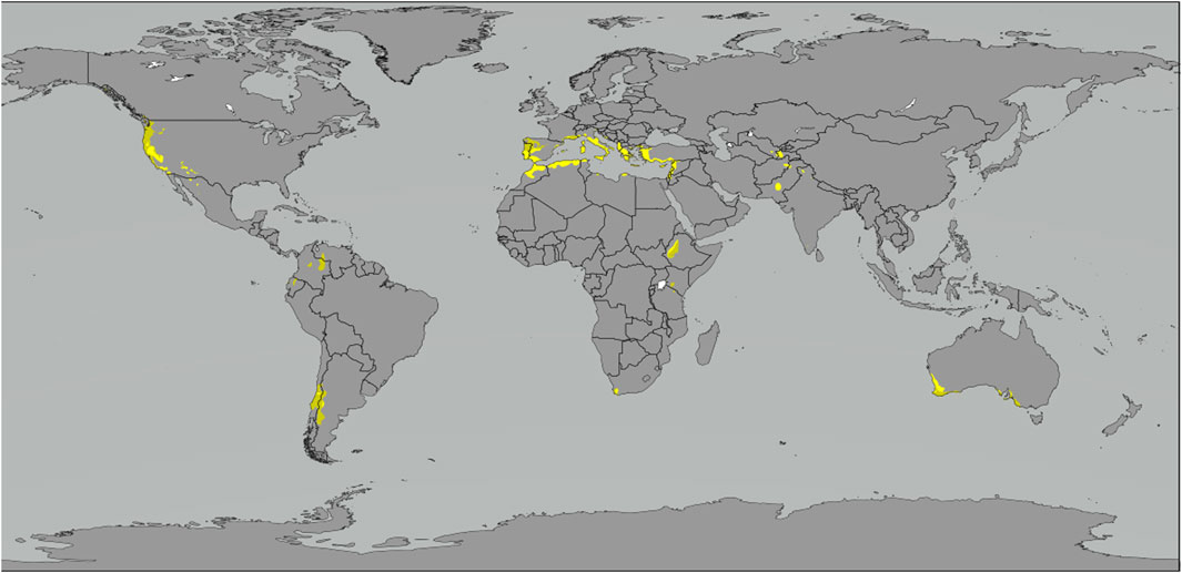
FIGURE 1. Regions with Mediterranean climate based on Köppen-Greiger classification. Yellow = Warm, Green = Temperate (Peel et al., 2007 and modified by Ali Zifan).
The vegetation is primarily represented by sclerophyllous shrublands, and, to a lesser extent, by grasslands, xerophytic woodlands, and pine forestations (Keeley et al., 2012). Mediterranean regions are considered hotspots of high biodiversity and are rich in endemic species. The Mediterranean basin, for example, is the second-largest biodiversity hotspot in the world (Myers et al., 2000). Mediterranean regions are considered attractive by people due to the mild climate (Keeley et al., 2012). Therefore, urban pressure, combined with Mediterranean climate characteristics, increases the risk of fire.
We selected ten countries with MTC areas where frequent fires occur in interface areas: Spain, France, Portugal, Italy, Greece (all part of the Mediterranean Basin), the USA, Australia, Chile, South Africa, and Argentina (Keeley et al., 2012) (Figure 1). In Argentina, the MTC extends over a semi-arid zone at approximately the same latitudes as the Mediterranean climate zone in central Chile but is separated by the Andes chain (Peel et al., 2007). This is a significant surface area where severe interface fires occur (de Torres Curth et al., 2012; Ghermandi et al., 2016; Godoy et al., 2022), likely more extended than that of Central Chile (Figure 1). We were able to analyze documents in English, Spanish, French, and Italian. As a result, we excluded some Mediterranean countries.
For each country, we conducted an exhaustive search for definitions of WUI areas, as well as fire prevention and management, among laws, regulations, and official plans, projects, and programs on the webpages of administrative bodies (e.g., Ministries) and agencies (e.g., Defense and Civil Protection, Forestry, and Fire Services) at different levels of the territorial organization within each country. The structure of the territorial organization and administrative bodies varied for each country, although, in general, it consists of three levels (Region; Province or Department; Commune or Municipality). The documents were not always available or accessible, thus we had to consult the agency managers via email (Spain, Italy, Greece, Australia, Portugal, and South Africa) and organize virtual meetings (Portugal). Some of these managers did not reply within a reasonable time (2 weeks), as was the case with Australia and Greece. In such instances, we analyzed the web documents in the best possible manner.
We read and analyzed each document searching for the following items: identification and definition of the WUI areas; the equivalent of WUI areas, when they are not explicitly named; nomenclature and typology; methodology for defining the WUI or its equivalent; justification for the buffer distance used when included in the methodology; fire prevention and management actions implemented in the WUI or its equivalent; levels of territorial organization and the agencies responsible for implementing actions; and the presence of a methodology and a map at national scale. The methodologies were described and then compared among countries.
WUI terminology
We found a lack of consensus regarding the nomenclature for WUI areas, named in various ways depending on the country. The USA, South Africa, and Greece used the term “wildland-urban interface”; Italy and Chile “urban-rural interface”; Spain, Argentina, and France refer to it as “urban-forest interface”, while Portugal uses the term “interface areas or zones”. The term rural is used in countries with a large history of dense human occupancy, like Europe, where the agricultural use of soil is very ancient. Australia employs the term “asset protection zones” which are associated with different risk zones, similar to France, where interface areas are color-coded based on fire risk levels (Table 1). A recent review based on scientific literature revealed the use of other terminology such as rural-forest interface, road-forest interface, and wildland-human interface, this being the least prevalent (Taccaliti et al., 2023). To simplify, we will henceforth use the term “wildland-urban interface”.

TABLE 1. Types of interface areas, methods to define them, buffer distance from the natural/rural area justification, actions undertaken in the WUI, and levels of territory organization (in bold, the responsible level of the actions) of Mediterranean countries (except Argentina and Greece). We analyzed the case of New South Wales (NSW) and Galicia as examples for Australia and Spain, respectively.
Methods and criteria to define the WUI
We have identified at least three general methods for defining WUI: considering buffer distance for urban and vegetation areas (USA, Italy, Chile, South Africa), employing networks of strips (Spain, Portugal), and delineating risk-prone zones (Australia, France). For Argentina, we were unable to find a methodology to define WUI areas. Similarly, in the case of Greece, we did not find information available on websites; thus, we based our research on scientific publications. Although we did not find a unique methodology to define the WUI areas, all methodologies incorporated at least two components: people and assets (i.e., houses, infrastructures, and/or industries) to protect, and vegetation near assets that increases fire risk. The lack of consensus on a unique methodology to define the WUI areas is related to, first, the concept of WUI and the terminology associated with interface fires remain unclear and are not universally adopted across countries (Modugno et al., 2016). Second, national policies for security management, prevention, and fire management in WUI areas are highly intricate, with complex enforcement mechanisms at all levels of a state, from national to municipal (Pastor et al., 2020). This complexity is further compounded in attempts to map the WUI on a large scale, as seen in Europe, due to legal heterogeneity, diverse WUI definitions, and administrative variations (Galiana et al., 2012; Modugno et al., 2016).
In the USA, three types of WUI areas are recognized: interface, intermix, and occluded areas (Federal Register, 1995; Table 1). The interface is defined as areas with ≥6.18 houses per km2 and <50% vegetation cover, situated at a buffer distance of <2.4 km from an area ≥5 km2 in size that is ≥ 75% vegetated. Intermix refers to areas with ≥6.18 houses per km2 and ≥50% cover of wildland vegetation (Martinuzzi et al., 2015) (Table 1). This approach documented in the Federal Register of the US (2001) ensures consistency in methodology application across the country. In fact, the USA is the only country with an official methodology for defining and mapping WUI areas at a national scale since 2010 (Martinuzzi et al., 2015; Radeloff et al., 2023; USDA, 2023). The USA was a pioneer in recognizing the problem of WUI fires, as well as in the description and application of the WUI concept (Butler, 1976). WUI protection and management were crucial for the Federal government due to the adjacency of federal lands to state lands and developed private lands (Federal Wildland Fire Management, 1995).
Italy, similar to the USA, categorizes WUI areas into three types: interface, mix, and occluded, without considering house density and vegetation cover percentage. The classic interface occurs when urbanization and vegetation are closely situated, the mixed interface involves isolated houses and infrastructures scattered in areas with abundant vegetation, and the occluded interface consists of vegetated areas surrounded by urban structures (Department of Civil Protection, 2007). The interface area is defined as a 25–50 m wide strip around urbanized areas, expanding to 200 m wide in steep terrains, which constitutes 75% of the country (Department of Civil Protection, 2007) (Table 1).
In Chile, the WUI is the transition zone where a forest plantation comes into contact with built-up, inhabited, and urban areas. WUI areas take into account a strip free of forest, and the width of this strip depends on the vulnerability of the urbanized area. The minimum width is 10 m for low, 15 m for medium, and 20 m for high vulnerability (CONAF, 2017) (Table 1).
In South Africa, the Green Book, a result of interdisciplinary research by the Council for Scientific and Industrial Research (CSIR) and municipal partners (CSIR, 2019), defined WUI. These areas consist of two 1 km-wide buffer zones: an interior one covering urbanized areas and an exterior one beyond, totaling 2 km in width. The 1 km wide buffer is justified by the potential travel distance of firebrands on the wind. The exterior buffer is utilized to analyze land cover classes for estimating the fuel load and fire hazard, while the interior buffer is employed to assess settlement vulnerability (Table 1).
In Spain and Portugal, three types of stripland networks exist: primary, secondary, and tertiary. In Spain, primary networks safeguard linear infrastructures such as highways, roads, railways, power lines, and gas pipelines. Secondary networks, analogous to interface areas, protect population centers, built-up areas, parks, and industrial estates. The 50 m wide strip of secondary networks surrounds built-up areas and infrastructure located within 400 m of the forest. The tertiary networks, situated in forested areas and those influenced by forests, are connected to public-use infrastructures for public use and those related to forest fire prevention, such as firebreaks (Table 1). In Portugal, secondary networks also safeguard communication infrastructures (e.g., routes, railway networks) and service infrastructures (e.g., power lines, gas pipelines) (AGIF, 2023). The strip around building areas is 100 m wide (Table 1).
Australia and France delineate risk zones for protection employing a detailed methodology to delineate these areas, integrating and weighing various factors outlined in their fire prevention and management plans (NSW Rural Fire Service, 2020; Préfet des Bouches-du-Rhöne, 2023). This categorization into risk areas facilitates prioritization and optimal fund and resource management. In Australia, like the USA, authorities identified the problem of WUI fires many years ago (Bento-Goncalves and Vieira, 2020), though a unified national-scale methodology was yet not developed. Because of this, we examined the plan of the New South Wales State (NSW) as an example. Despite NSW not being situated in a Mediterranean climate region, we chose this state because, along with Victoria and South Australia, it experienced a catastrophic mega-fire during the Black summer fires of 2020 (Filkov et al., 2020). In the Bush Fire Risk Management Plan (BFRMP), community asset risk and vulnerability were assessed to define “asset protection zones.” The term “bushfires” refers to wildfires in Australia. First, assets at risk are identified and include human settlements (residential areas, schools, hospitals, commercial and industrial zones), economic assets (agriculture, industries, pipelines, tourism, recreation areas), environmental assets (species, ecosystems sensitive to fire, Ramsar wetlands), and cultural assets (Aboriginal significance, non-indigenous heritage). Second, the level of bushfire risk and consequence ratings are identified. Different assessment processes determine the consequence and likelihood ratings for each asset type. For instance, for human settlement assets, a fire behavior model considers vegetation type, slope, and separation distance to establish threat and vulnerability ratings. Overall risk evaluation considers the appropriateness of assigned risk levels, identifies assets needing treatment, and prioritizes treatments. Finally, Bush Fire Management Zones, including asset protection zones, strategic fire advantage zones, land management zones, and fire exclusion zones, are mapped for fire risk reduction, with the “asset protection zone” covering human settlement assets (NSW Rural Fire Service, 2020).
In France, the Fire Risk Prevention Plan (PPRIF) incorporates a regulatory municipal map based on three factors: fire hazard (linked to vegetation and topography), assets (including built areas, communication infrastructure, and cultural values), and defensibility (availability of firefighting equipment). Each zone is assigned a color code (red or blue, with varying intensities): red zones denote very high risk, prioritizing the safety of buildings and human activities, with new constructions prohibited. In intense blue zones, B1 (moderate to high risk), defensibility is assured, and urban development is contingent on population density and the provision of protective facilities. In intermediate blue zones, B2 (moderate risk), defensibility can be enhanced, and urban development is subject to both individual and collective preventive measures. In light blue zones, B3 (low to very low risk), the focus is on reducing building vulnerability and improving defensibility (Préfet des Bouches-du-Rhöne, 2023) (Table 1). The Forest Code also mandates that in interface areas, property owners must remove the vegetation at 50 m around buildings located within 200 m of the forest.
One of the less defined parameters for the WUI is the buffer zone, representing the distance between the urban settlements and vegetation (Radeloff et al., 2005). This distance varies significantly among countries, relying on factors such as the travel distance of firebrands by wind from wildfires in the USA (2.4 km, California Fire Alliance, 2001) and South Africa (1 km, Blanchi et al., 2006; Alexandre et al., 2016), the level of urban area vulnerability in Chile (0.01–0.02 km, CONAF, 2017), and the physical characteristics of the territory and settlements in Italy (0.025–0.050 km–0.200 km, Department of Civil Protection, 2007). The transport of firebrands by the fire plume and the wind stands out as a primary cause of spot fires. The distance that a firebrand can travel depends on several factors, including the burning vegetation type and height, wind speed, and ember size. The characteristics of the combustion of the firebrand add complexity to calculating their transport (Manzello et al., 2020). This complexity needs a thorough study for the development of predictive models. The absence of quantitative evidence may result in a skewed perception of risks in the WUI, leading to suboptimal resource allocation across different jurisdictional levels (Song et al., 2017).
Agencies responsible for fire prevention and management plans
Generally, actions were proposed by the first or second level of the territorial organization, such as regions, provinces, or autonomous communities, depending on the country. The enforcement authority usually lay at the third level, such as municipalities (Table 1). In the USA, the Federal Land Management Agencies (including Forestry Service, Bureau of Land Management, U.S. Fish and Wildlife Service, and National Park Services) along with the states, tribes, and local governments collaborate on formulating prevention plans. Meanwhile, in Italy, many regions refer to the operational manual of the Department of Civil Protection (2007) to develop prevention plans in compliance with Forest Fires Law 353/2000 (Normativa, 2023). In Chile, the National Forestry Corporation (CONAF) oversees fire prevention and firefighting planning in interface zones (CONAF, 2017), collaborating with other ministries such as the Ministry of Public Works and the Ministry of Economy. Municipalities develop fire protection plans, considering factors such as risk, hazard, and potential damage. In Spain, the Law of Montes 43/2003 authorizes each autonomous community to implement protective measures for urban centers and infrastructures that mitigate the risk of fires. Taking the example of the autonomous community of Galicia, which faces recurring severe fires (Galiana Martín, 2012), The Xunta of Galicia is tasked with formulating the PLADIGA, the Plan of Prevention and Defense against Forest fires in Galicia (Law 3/2007; BOE, 2007; Xunta de Galicia, 2023). In Portugal, the functions of the Integrated Rural Fire Management System, responsible for the planning and implementing measures for the prevention, control, and management of fires, are outlined in Decree Law 13 October 82/2021 (Diário da República, 2021). In Australia, the Rural Fires Act 1997 N° 65 (NSW Legislation, 1997) authorizes the establishment of a Bush Fire Management Committee (BFMC) for regions prone to bushfire risk in each state. The BFMC is required to develop a Bush Fire Risk Management Plan (BFRMP) and a Community Plan (NSW Rural Fire Service, 2020). The Community Plan is designed to minimize the impact of bushfires on life, property, and the environment.
Fire prevention actions in the WUI
Generally, the actions conducted in WUI areas at the municipal level involve preventive measures, such as fuel management (i.e., biomass removal) and the construction of firebreaks (Table 1). In Chile, the prevention plans prescribe the creation of firebreak strips 30–80 m inside the forests, depending on the vulnerability of urban areas. In Italy, hazard, vulnerability, and risk are also analyzed in these areas, and preventive actions are implemented by the Civil Protection, the State Forestry Corps, and the National Fire Brigade as enforcement agencies. In South Africa, the Fire Protection Associations (FPASs) are entities that implement fire management and fire risk reduction in the WUI. FPAs form of partnership between private landowners and government fire authorities and have legal standing under the National Veld and Forest Fire Act 101 of 1998 (South African Government, 2023). “Veldfires” is the term used in South Africa for forest and bushfires.
The case of Greece and Argentina
For Greece, we could find no documents or maps available on the official website (Civil Protection, 2023). We found academic papers that have delimited the interface areas, such as Ganatsas et al. (2022). Following the 2018 Attica forest fire, which resulted in 102 deaths and over 1650 homes being destroyed (Xanthopoulous and Athanasiou, 2019), the Independent Commission was established to investigate future forest and rural fire prospects in Greece. This led to the enactment of a legislative decree for the establishment of a National Mechanism for Crisis Management and Risk Management. Consequently, the Ministry of Climate Crisis and Civil Protection, along with the General Secretariat for Civil Protection and the Fire Brigade, underwent reorganization (Zikeloglou et al., 2023).
Mitsoupolous et al. (2020), a member of the Ministry of Environment and Energy, provided a national-scale map of interface areas for authorities involved in landscape fire management. The methodology used to define the interface areas follows Modugno et al. (2016), who created WUI maps for the EU (excluding Greece). Bachantourian et al. (2023), a member of the Hellenic Forest Service and Ministry of Environment and Energy, developed small-scale fire simulation models and maps to identify high-priority areas for fuel management in Kassandra peninsula, located 60 km from Thessaloniki. This study considered various variables, including proximity to urban development, and influenced local forest management. The findings were applied through the Antinero Forest Preventive Clearing Program (OECD iLibrary, 2023) funded and implemented by the Ministry of Environment and Energy in collaboration with the Ministry of Climate Crisis and Civil Protection. The Antinero Program involves the removal of fuel accumulated over decades in a total area of 80,000 ha and in more than 100 forest ecosystems, along with the maintenance and opening of forest roads. Therefore, it serves as a valuable tool for forest management planning and has the potential for replication in other regions of Greece.
In Argentina, despite the occurrence of significant fires resulting in fatalities and considerable economic losses (Godoy et al., 2022), fire risk and hazard maps (although not WUI maps) have been developed only recently (IDECOR, 2020; 2022). The National Fire Management Service (SNMF), under the Ministry of Environment and Sustainable Development, has created a document focusing on the prevention of fires in interface areas. The document includes general prevention measures and assesses the vulnerability of housing and communities and guidelines for citizens to protect themselves (Ciampioli et al., 2018). However, it lacks explicit mentions of definitions for WUI and corresponding management actions.
In 2017, Law 27 287, established the National System for Integrated Risk Management and Civil Protection (SINAGIR), coordinated by the Ministry of Security. SINAGIR aims to integrate the efforts of national government agencies, provincial governments, the Buenos Aires government, municipalities, NGOs, and civil society to enhance actions for preventing and reducing fire risks. Despite developing the National Plan for Disaster Risk Reduction 2018–2023, which promotes federal cooperation and integrated warning networks, the document does not explicitly address fire prevention (SINAGIR, 2023). Recently, in April 2023, the National System of Alert and Monitoring of Emergencies (SINAME) was established to consolidate different alert systems and serve as the primary tool for information exchange, observation, and monitoring of disasters, including fires.
As explained before, a vast area of Patagonia, including the Río Negro province, experiences a Mediterranean climate. The legislature of Rio Negro mandates the development of the Provincial Plan of Risk and Vulnerability Analysis for the Prevention of Forest Fires. This plan is required to encompass territorial information, risk and vulnerability analyses, and maps. The specific contents are to be regulated by the Forest Fire Prevention and Fighting Service (SPLIF) and necessitate the adherence of national and municipal jurisdictions.
Simultaneously, the Andean Forest Service and SPLIF have initiated management actions to mitigate fire risks in both public and private areas. In the province of Chubut, following the declaration of the state of fire disaster on 10/03/2021 by Decree 1253/2021 (Sistemas Chubut, 2021), the Integral Program for Prevention, Mitigation, Remediation, and Restoration of areas affected by forest fires was established. The program aims to reduce vulnerability in urban-forest interface areas through planning actions, awareness programs, and protection and prevention initiatives. The Provincial Agricultural Services Program (PROSAP) of the Ministry of Economy is executing a project to enhance the Provincial Fire Management Service (SPMF) in northwest Chubut (2016), with the goal of decreasing forest fire occurrences and related losses. The proposal includes creating firebreaks and developing an urban-forest interface risk map, although the methodology is yet to be defined (PROSAP, 2016). Concrete actions by SPMF, such as acquiring specific machinery for fire prevention have already been implemented (Bariloche opina, 2023). In Córdoba, the Provincial Spatial Data Infrastructure (IDECOR) developed a local forest fire risk map for two regions (La Granja, 2020 and Corredor de Sierras Chicas and Jesús María, 2022), integrating anthropogenic factors (distance to population centers, population density, accessibility) and environmental factors (relief, type of vegetation cover) and a vulnerability map (socio-economic, educational conditions, infrastructure) (IDECOR, 2020; 2022). Despite Cordoba being in a non-Mediterranean area, this example is noteworthy because of its clear and detailed methodology. At a municipality level, the Direction of Civil Protection of Bariloche (Río Negro province) created an interface risk map by combining vulnerability data from neighborhoods (proximity to natural areas, mobility), and the threats, which encompass topographical features and vegetation combustibility (Secretary of Civil Protection of Bariloche, 2020).
Maps at a national scale
The USA is the only country that has created an official map of the interface area (1990–2020) at the federal-state level, using a standard methodology developed by researchers of the University of Wisconsin-Madison (Radeloff et al., 2023) in collaboration with the Forest Service, which operates under the U.S. Department of Agriculture Forest Service (USDA, 2023). The map is based on geographic information systems that integrate the U.S. census and U.S. Geological Service National Land Cover data.
In Portugal, the General Direction of Territory (DGT), in collaboration with the Institute for the Conservation of Nature and Forests (ICNF), is currently developing two interface area maps for the territory: the Structural Built Area Interface Map 2018, updated every 10 years, and the Temporary Built Area Interface Map 2022, updated annually (SNIG, 2023). To create the latter map, the perimeter of each built area was subdivided into segments of 25 m, which were classified into four types: 1. Direct segment in contact with patches of fuel ≥0.1 ha at a distance ≤10 m; 2. Indirect segment 1 in contact with patches of fuel ≥0.1 ha at distances of 10–100 m; 3. Indirect segment 2 in contact with patches of fuel ≥1 ha at distances of 100–500 m; and 4. The remaining segments (more than 100 m from fuel patches with ≥0.1 ha and more than 500 m from fuel patches ≥1 ha) (DGT, 2023).
Interaction between academic and fire management agencies
Based on the inquiries we made through email with the relevant authorities in the prevention and fighting of WUI fires in Italy, Spain, and South Africa, and from virtual meetings with those in Portugal, as well as in-person meetings with those in Argentina, we conclude that the current protocols do not derive from the numerous scientific studies published in scientific journals but rather from training in topics related to environmental risks such as floods, volcanic eruptions, earthquakes, and fires. The same conclusion was drawn from the reading of various academic papers, in which it is suggested that the methods developed could have interesting applications for land and fire management (Lampin-Maillet et al., 2010; Bachantourian et al., 2023). This implies that there is currently no instance of joint work between researchers and fire managers, with the exception of the USA, where a program (The Joint Fire Science Program) is designed to connect scientists and fire managers (although it is not specifically focused on WUI issues) (firescience.gov, 2023). In our view, this would be auspicious, given that states invest money in funding research. At the same time, all states relegate the prevention and fight against WUI fires to civil protection, which is governed by laws, regulations, and codified plans and actions.
Investment funds for fire prevention and management
Within the analyzed countries, significant economic differences exist, with two of them being developing countries (Argentina and Chile). These differences have implications in terms of the funds allocated to WUI fire prevention. Thus, the economy is a key variable. Also, in Argentina, there is no active federal fire policy, and public investments are primarily directed toward suppression efforts, such as the acquisition of firefighting equipment (Argentina.gob.ar, 2022). This is repeated worldwide, in the USA the funding allocated for prevention is overshadowed by funds allocated for suppression, and in high fire years, prevention funds are occasionally diverted to suppression. For instance, in 2022, approximately $200 million was allocated for prevention compared to $650 million for suppression (U.S. Department of Interior, 2023). In the context of climate change and with the increase in the frequency of mega-fires, it is imperative to shift the focus from firefighting to fire prevention, which includes the investments of funds.
Final remarks
Until now, there has been no review of the methods to define the WUI effectively implemented by fire management agencies. Our review addresses this gap and highlights two main shortcomings: the methodologies are not standardized even in the same country and the need to implement actions aimed at integrating scientific work conducted in WUI into fire prevention and management plans and protocols in a more interactive and integrated manner. Regarding the first, each country has its own legal framework and state agencies that determine proposals for fire prevention and management in plans and programs. Given this complexity, we acknowledge that developing and adopting a standard methodology appears to be a challenging task.
Regarding the second, we believe that there should be a state policy oriented toward implementing programs and spaces that facilitate the exchange of ideas and address needs focused on encouraging scientific-technical interaction. In these spaces, fire managers can articulate their requirements, and fire researchers can align their investigations to address those needs in WUI. An example of interaction is evident in the USA and Portugal, where collaborative efforts between the academic and technical sectors led to the development of a unified methodology for defining WUI areas and mapping them at a national scale, demonstrating the feasibility of such interaction. We believe that implementing this proposal would serve as an effective strategy to strengthen partnerships, consolidate efforts, and optimize the utilization of resources and funds.
Data availability statement
The original contributions presented in the study are included in the article/Supplementary material, further inquiries can be directed to the corresponding author.
Author contributions
SG: Conceptualization, Formal Analysis, Investigation, Methodology, Validation, Writing–original draft, Writing–review and editing. LG: Formal Analysis, Investigation, Methodology, Validation, Writing–original draft, Writing–review and editing, Conceptualization.
Funding
The author(s) declare that no financial support was received for the research, authorship, and/or publication of this article.
Acknowledgments
We are very grateful to Arlindo Pino dos Santos and Yannick Le Page (Agência para a Gestão Integrada de Fogos Rurais, Lisboa, Portugal), Fernando Veiga Aguiar (Subdirector Xeral de Extinción, Dirección Xeral de Defensa do Monte, Consellería do Medio Rural, Galicia, Spain), Nazareno Santilli (Protezione Civile, Italy), William Bond (University of Cape Town, South Africa), Greg Forsyth (South Africa) for your willingness to answer our queries by email and even by virtual meetings, and Charlotte Reemts for English revision.
Conflict of interest
The authors declare that the research was conducted in the absence of any commercial or financial relationships that could be construed as a potential conflict of interest.
Publisher’s note
All claims expressed in this article are solely those of the authors and do not necessarily represent those of their affiliated organizations, or those of the publisher, the editors and the reviewers. Any product that may be evaluated in this article, or claim that may be made by its manufacturer, is not guaranteed or endorsed by the publisher.
References
AGIF (2023). Agência para a Gestão Integrada de Fogos Rurais. Normas técnicas para elaboração da cartografia das redes de defesa, 56.
Alcasena, F., Evers, C., and Vega-García, C. (2018). The wildland-urban interface raster dataset of Catalonia. Data Brief 17, 124–128. doi:10.1016/j.dib.2017.12.066
Alexandre, P. M., Stewart, S., Keuler, N., Clayton, M. K., Mockrin, M. H., Bar-Massada, A., et al. (2016). Factors related to building loss due to wildfires in the conterminous United States. Ecol. Appl. 26, 2323–2338. doi:10.1002/eap.1376
Andrada, M. E., Russell, D., Arevalo-Ramirez, T., Kuang, W., Kantor, G., and Yandun, F. (2023). Mapping of potential fuel regions using uncrewed aerial vehicles for wildfire prevention. Forests 14 (8), 1601. doi:10.3390/f14081601
Argañaraz, J. P., Radeloff, V. C., Bar-Massada, A., Gavier-Pizarro, G. I., Scavuzzo, C. M., and Bellis, L. M. (2017). Assessing wildfire exposure in the Wildland-Urban Interface area of the mountains of central Argentina. J. Environ. Manag. 196, 499–510. doi:10.1016/j.jenvman.2017.03.058
Argentina.gob.ar (2022). El Gobierno invierte cerca de 150 millones de pesos en prevención y combate contra los incendios forestales en Tucumán. Available at: https://www.argentina.gob.ar/noticias/el-gobierno-invierte-cerca-de-150-millones-de-pesos-en-prevencion-y-combate-contra-los (Accessed August 28, 2023).
Atlas, CMCC (2023). G20 Climate risk atlas. Available at: https://www.cmcc.it/g20 (Accessed August 28, 2023).
Bachantourian, M., Kalabokidis, K., Palaiologou, P., and Chaleplis, K. (2023). Optimizing fuel treatments allocation to protect the wildland–urban interface from large-scale wildfires in Greece. Fire 6, 75. doi:10.3390/fire6020075
Balch, J. K., Bradley, B. A., Abatzoglou, J. T., Nagy, R. C., Fusco, E. J., and Mahood, A. L. (2017). Human-started wildfires expand the fire niche across the United States. Proc. Natl. Acad. Sci. 114 (11), 2946–2951. doi:10.1073/pnas.1617394114
Bariloche Opina (2023). Bariloche opina. Available at: https://www.barilocheopina.com/noticias/2023/04/18/65867-el-bolson-entregan-maquinaria-para-colaborar-en-la-prevencion-de-incendios (Accessed August 28, 2023).
Bar-Massada, A., Stewart, S. I., Hammer, R. B., Mockrin, M. H., and Radeloff, V. C. (2013). Using structure locations as a basis for mapping the wildland-urban interface. J. Environ. Manag. 128, 540–547. doi:10.1016/J.JENVMAN.2013.06.021
Bento-Gonçalves, A., and Vieira, A. (2020). Wildfires in the wildland-urban interface: key concepts and evaluation methodologies. Sci. Total Environ. 707, 135592. doi:10.1016/j.scitotenv.2019.135592
Blanchi, R., Leonard, J. E., and Leicester, R. H. (2006). Lessons learnt from post-bushfire surveys at the urban interface in Australia. For. Ecol. Manag. 234, 139. doi:10.1016/j.foreco.2006.08.184
BOE (2007). Ley 3/2007, 9 Abril, de prevención y defensa contra incendios forestales de Galicia. Madrid, Spain: Boletín Oficial del Estado, 47.
Bowman, D. M., Moreira-Muñoz, A., Kolden, C. A., Chávez, R. O., Muñoz, A. A., Salinas, F., et al. (2019). Human–environmental drivers and impacts of the globally extreme 2017 Chilean fires. Ambio 48, 350–362. doi:10.1007/s13280-018-1084-1
Butler, C. P. (1976). The urban/wildland fire interface. Fire Prev. Notes. Calif. Dep. For. 10, 2–14.
Caballero, D. (2008). “Wildland–urban interface fire risk management: WARM Project,” in Proceedings of the second international symposium on fire economics, planning and policy: a global view. Editor A. González-Cabán (Albany, CA, USA: US Department of Agriculture, Forest Service), 473–483. Pacific Southwest Research Station, General Technical Report PSW-GTR-208. doi:10.2737/PSW-GTR-208
Caballero, D., Beltrán, I., and Velasco, A. (2007). “Forest fires and wild land-urban interface in Spain: types and risk distribution,” in 4th International Wild land Fire Conference, Seville, Spain, January 2007.
California Fire Alliance (2001). Characterizing the fire threat to wildland urban interface. Sacramento, CA, USA. Available at: https://frap.fire.ca.gov/projects/wui/525_CA_wui_analysis (Accessed August 27, 2023).
CEREMA (Climate and Territoires de Demain) (2023). Plans de prevention des risques naturals (PPR) Risques d´incendies de forêt. Guide méthodologique. Available at: https://outil2amenagement.cerema.fr/le-plan-de-prevention-des-risques-d-incendies-de-r1539.html (Accessed August 28, 2023).
Chubut, S. (2021). Decree 1253/2021. Available at: https://sistemas.chubut.gov.ar/digesto/sistema/consulta.php?idile1=80534 (Accessed August 28, 2023).
Ciampoli, C., Mansilla, V., Scandalo, R., Vasquez, M., and Ventini, A. (2018). Prevención de incendios de interfase urbano forestal. Argentina: Ministerio de Ambiente y Desarrollo Sustentable, 21.
Civil Protection (2023). Webpage of civil protecion of Greece. Available at: https://civilprotection.gov.gr/ekdoseis (Accessed August 28, 2023).
CONAF (Consejo de Política Forestal) (2017). Protocolo de Plantaciones forestales. Informe de Gestión. Available at: https://www.conaf.cl/incendios-forestales/prevencion/regulacion/ (Accessed August 27, 2023).
CORDIS (2001). WARM. Available at: https://cordis.europa.eu/project/id/EVG1-CT-2001-00044 (Accessed August 28, 2023).
CORDIS (2023). Comisión europea. Available at: https://cordis.europa.eu/es (Accessed August 28, 2023).
CSIR (2019). “Wildfires: the impact of climate change on wildfires in South Africa,” in GreenBook national overview. Available at: https://pta-gis-2-web1.csir.co.za/portal/apps/GBCascade/index.html?appid=a726c58f435141ba80b57fe21d3ec744 (Accessed August 20, 2023).
da República, D. (2021). Decreto-Lei n.º 82/2021. Available at: https://files.dre.pt/1s/2021/10/19900/0000200047.pdf (Accesed August 28, 2023).
de Galicia, X. (2023). Pladiga 2023 Plan de Prevención y Defensa contra los incendios forestales de Galicia. Available at: https://mediorural.xunta.gal/es/temas/defensa-monte/pladiga-2023 (Accessed August 27, 2023).
Department of Civil Protection (2007). Manuale operativo per la predisposizione de un piano comunale o intercomunale di protezione civile. Italy: Protezione civile.
de Torres Curth, M., Biscayart, C., Ghermandi, L., and Pfister, G. (2012). Wildland–Urban interface fires and socioeconomic conditions: a case study of a northwestern Patagonia city. Environ. Manag. 49, 876–891. doi:10.1007/s00267-012-9825-6
DGT (2023). Direcao-Geral do Território. Carta de áreas edificadas e cartas de interfaces de áreas edificadas para Portugal continental, 6.
European Commission (2021). Joint research Centre. Available at: https://commission.europa.eu/about-european-commission/departments-and-executive-agencies/joint-research-centre_en (Accesed August 27, 2023).
Federal Wildland Fire Management (1995). Final report. IIdaho, United States: U.S. Department of the Interior, U.S. Department of Agriculture, 45.
Filkov, A. I., Ngo, T., Matthews, S., Telfer, S., and Penman, T. D. (2020). Impact of Australia’s catastrophic 2019/20 bushfire season on communities and environment. Retrospective analysis and current trends. J. Saf. Sci. Resil. 1 (1), 44–56. doi:10.1016/j.jnlssr.2020.06.009
Fire Science gov (2023). Joint fire science program. Available at: https://www.firescience.gov/ (Accessed December 21, 2023).
Flannigan, M. D., Krawchuk, M. A., De Groot, W. J., Wotton, B. M., and Gowman, L. M. (2009). Implications of changing climate for global wildland fire. Int. J. Wildland Fire 18, 483–507. doi:10.1071/WF08187
Galiana-Martín, L. (2012). Las interfaces urbano-forestales: un nuevo territorio de riesgo en España. Bol. Asoc. Geógr. Españoles 58, 205–226. doi:10.21138/bage.2065
Ganatsas, P., Oikonomakis, N., and Tsakaldimi, M. (2022). Small-scale analysis of characteristics of the wildland–urban interface area of Thessaloniki, northern Greece. fire 5, 159. doi:10.3390/fire5050159
Ganteaume, A., Barbero, R., Jappiot, M., and Maillé, E. (2021). Understanding future changes to fires in southern Europe and their impacts on the wildland–urban interface. J. Saf. Sci. Resil. 2, 20–29. doi:10.1016/j.jnlssr.2021.01.001
Ghermandi, L., Beletzky, N. A., de Torres Curth, M. I., and Oddi, F. J. (2016). From leaves to landscape: a multiscale approach to assess fire hazard in wildland-urban interface areas. J. Environ. Manag. 183, 925–937. doi:10.1016/j.jenvman.2016.09.051
Godoy, M., Martinuzzi, S., Masera, P., and Defossé, G. E. (2022). Forty years of wildland urban interface growth and its relation with wildfires in central-western Chubut, Argentina. Front. For. Glob. Change 5, 850–543. doi:10.3389/ffgc.2022.850543
Godoy, M. M., Martinuzzi, S., Kramer, H. A., Defossé, G. E., Argañaraz, J., and Radeloff, V. C. (2019). Rapid WUI growth in a natural amenity-rich region in central-western Patagonia, Argentina. Int. J. Wildland Fire 28 (7), 473–484. doi:10.1071/WF18097
IDECOR (2020). Informe Mapas de Riesgo Local para Incendios Forestales. Estudio Piloto La Granja, Provincia de Córdoba. Infraestructura de Datos Espaciales de la Provincia de Córdoba. Available at: https://idecor.cba.gov.ar/wp-content/uploads/2020/12/Informe-Ejecutivo-Riesgo-de-Incendio-La-Granja.pdf (Accessed August 28, 2023).
IDECOR (2022). Mapas de Riesgo Local para Incendios Forestales Corredor Sierras Chicas y Jesús María 2022. Infraestructura de Datos Espaciales de la Provincia de Córdoba. Available at: https://www.idecor.gob.ar/actualizacion-del-mapa-de-riesgo-ante-incendios-se-completa-el-corredor-sierras-chicas/ (Accessed August 28, 2023).
Joffre, R., and Rambal, S. (2002). “Mediterranean ecosystems,” in Encyclopedia of life sciences (Macmillan Publishers Ltd), 7.
Keeley, J. E., Bond, W. J., Bradstock, R. A., Pausas, J. G., and Rundel, P. W. (2012). Fire in Mediterranean ecosystems: ecology, evolution and management. New York, USA: Cambridge University Press.
Lampin-Maillet, C., Jappiot, M., Long, M., Bouillon, C., Morge, D., and Ferrier, J.-P. (2010). Mapping wildland-urban interfaces at large scales integrating housing density and vegetation aggregation for fire prevention in the South of France. J. Environ. Manag. 91 (3), 732–741. doi:10.1016/j.jenvman.2009.10.001
Légifrance (2023). Code forestier. Available at: https://www.legifrance.gouv.fr/codes/texte_lc/LEGITEXT000025244092/ (Accessed August 28, 2023).
legislation, N. S. W. (1997). The rural fire Act 1997. Available at: https://legislation.nsw.gov.au/view/html/inforce/current/act-1997-065#sec.52 (Accessed August 20, 2023).
Manzello, S. L., Suzuki, S., Gollner, M. J., and Fernandez,-Pello, C. (2020). Role of firebrand combustion in large outdoor fire spread. Prog. Energy Combust. Sci. 76, 100801. doi:10.1016/j.pecs.2019.100801
Martinuzzi, S., Stewart, S., Helmers, D., Mockrin, M., Hammer, R., and Radeloff, V. (2015). The 2010 wildland-urban interface of the conterminous United States.Research Map NRS-8. Newtown Square, PA: U.S. Department of Agriculture, Forest Service, Northern Research Station, 124.
Marzano, R., Camia, A., and Bovio, G. (2014). “Wildland-urban interface analyses for fire management planning 1,” in Proceedings of the Second International Symposium on Fire Economics, Planning, and Policy: A Global View, Córdoba, Spain, 9–22 April 2004, 311–318.
Miranda, A., Carrasco, J., González, M., Pais, C., Lara, A., Altamirano, A., et al. (2020). Evidence-based mapping of the wildland-urban interface to better identify human communities threatened by wildfires. Environ. Res. Lett. 15, 094069. doi:10.1088/1748-9326/ab9be5
Mitsopoulos, I., Mallinis, G., Dimitrakopoulos, A., Xanthopoulos, G., Eftychidis, G., and Goldammer, J. G. (2020). Vulnerability of peri–urban and residential areas to landscape fires in Greece: evidence by wildland-urban interface data. Data Brief 31, 106025. doi:10.1016/j.dib.2020.106025
Modugno, S., Balzter, H., Cole, B., and Borrelli, P. (2016). Mapping regional patterns of large forest fires in wildland-Urban interface areas in Europe. J. Environ. Manag. 172, 112–126. doi:10.1016/j.jenvman.2016.02.013
Molina-Terrén, D. M., Xanthopoulos, G., Diakakis, M., Ribeiro, L., Caballero, D., Delogu, G. M., et al. (2019). Analysis of forest fire fatalities in southern Europe: Spain, Portugal, Greece and sardinia (Italy). Int. J. Wildland Fire 28, 85–98. doi:10.1071/WF18004
Myers, N., Mittermeier, R., Mittermeier, C., da Fonseca, G., and Kent, J. (2020). Biodiversity hotspots for conservation priorities. Nature 403, 853–858. doi:10.1038/35002501
Normativa (2023). Italian forest fires law 353/2000. Available at: https://www.normattiva.it/uri-res/N2Ls?urn:nir:stato:legge:2000;353 (Accessed August 27, 2023).
NSW Fire Service (2020). Bush fire risk management plan 2020. Available at: https://www.rfs.nsw.gov.au/ (Accessed August 20, 2023).
Nunes, A. N., Figueiredo, A., Pinto, C., and Lourenço, L. (2023). Assessing wildfire hazard in the wildland–urban interfaces (WUIs) of Central Portugal. Forests 14, 1106. doi:10.3390/f14061106
OECD ilibrary (2023). Taming wildfires in the context of climate change. Available at: https://www.oecd-ilibrary.org/sites/a641befeen/index.html?itemId=/content/component/a641befe-en (Accessed August 28, 2023).
Pastor, E., Muñoz, J. A., Caballero, D., Agueda, A., Dalmau, F., and Planas, E. (2020). Wildland–urban interface fires in Spain: summary of the policy frameworkand recommendations for improvement. Fire Technol. 56, 1831–1851. doi:10.1007/s10694-019-00883-z
Pausas, J. G., and Keeley, J. E. (2021). Wildfires and global change. Front. Ecol. Environ. 19 (7), 387–395. doi:10.1002/fee.2359
Pausas, J. G., Keeley, J. E., and Schwilk, D. W. (2017). Flammability as anecological and evolutionary driver. J. Ecol. 105, 289–297. doi:10.1111/1365-2745.12691
Peel, M. C., Finlayson, B. L., and McMahon, T. A. (2007). Updated world map of the Köppen-Geiger climate classification. Hydrology Earth Syst. Sci. 11, 1633–1644. doi:10.5194/hess-11-1633-2007
Préfet des Bouches-du-Rhöne (2023). Le PPRIF, c’est quoi ? Available at: https://www.bouches-du-rhone.gouv.fr/contenu/telechargement/14326/82027/file/pprif_plaket_13mars_p.pdf (Accessed August 28, 2023).
PROSAP (Programa de Servicios Agrícolas Provinciales) (2016). Mejoramiento del servicio provincial de manejo del fuego (SPMF) para la prevención y control de incendios en el noroeste de Chubut (Argentina), Anexo VIII: evaluación de impacto ambiental y social, 203.
Radeloff, V., Helmers, D., Mockrin, M., Carlson, A., Hawbaker, T., and Martinuzzi, S. (2023). The 1990-2020 wildland-urban interface of the conterminous United States - geospatial data. 3. United States: Forest Service Research Data Archive. (Accessed August, 20 2023). doi:10.2737/RDS-2015-0012-3
Radeloff, V. C., Hammer, R. B., Stewart, S. I., Fried, J. S., Holcomb, S. S., and McKeefry, J. F. (2005). The wildland–urban interface in the United States. Ecol. Appl. 15, 799–805. doi:10.1890/04-1413
Radeloff, V. C., Helmers, D. P., Kramer, H. A., Mockrin, M. H., Alexandre, P. M., Bar-Massada, A., et al. (2018). Rapid growth of the US wildland–urban interface raises wildfire risk. Proc. Natl. Acad. Sci. 115, 3314–3319. doi:10.1073/pnas.1718850115
Register, F. (2001). Urban wildland interface communities within the vicinity of federal lands that are at high risk from wildfire 66(3)751-777. Available at: https://www.federalregister.gov/ (Accessed August 26, 2023).
Rovithakis, A., Grillakis, M. G., Seiradakis, K. D., Giannakopoulos, C., Karali, A., Field, R., et al. (2022). Future climate change impact on wildfire danger over the Mediterranean: the case of Greece. Environ. Res. Lett. 17 (4), 045022. doi:10.1088/1748-9326/ac5f94
San-Miguel-Ayanz, J., Durrant, T., Boca, R., Libertá, G., Branco, A., de Rigo, D., et al. (2018). Forest fires in Europe, Middle East and north Africa 2017. Italy: Publications Office of the European Union. EUR 29318 (Accessed 7 January, 2019). doi:10.2760/663443
Sanucci, C., Gonzalez, S., and Ghermandi, L. (2022). Mapping the wildland-urban interface from houses location and terrain slope in Patagonia, Argentina. Environ. Sci. Proc. 22, 14. doi:10.3390/IECF2022-13041
Sarricolea, P., Serrano-Notivoli, R., Fuentealba, M., Hernández-Mora, M., de la Barrera, F., Smith, P., et al. (2020). Recent wildfires in Central Chile: detecting links between burned areas and population exposure in the wildland urban interface. Sci. Total Environ. 706, 135894. doi:10.1016/j.scitotenv.2019.135894
Schug, F., Bar-Massada, A., Carlson, A., Cox, H., Hawbaker, T. J., Helmers, D., et al. (2023). The global wildland–urban interface. Nature 621, 94–99. doi:10.1038/s41586-023-06320-0
Seager, R., Osborn, T. J., Kushmir, Y., Liu, H., and Nakamura, J. (2019). Climate variability and change of mediterranean-type climates. J. Clim. 32 (10), 2887–2915. doi:10.1175/JCLI-D-18-0472.1
SINAGIR (2023). Sistema Nacional para la Gestión Integral del Riesgo. Available at: https://www.argentina.gob.ar/sinagir (Accessed August 28, 2023).
Sirca, C., Casula, F., Bouillon, C., Fierro García, B., Fernández Ramiro, M. M., Vila Molina, B., et al. (2017). A wildfire risk oriented GIS tool for mapping rural-urban interfaces. Environ. Model. Softw. 94, 36–47. doi:10.1016/j.envsoft.2017.03.024
SNIG (2023). Sistema nacional de Informacao geográfica. Available at: https://snig.dgterritorio.gov.pt/rndg/srv/por/catalog.search#/metadata/c1eae781-0812-43f0-96a5-ed67df9ca739 (Accessed August 28, 2023).
Song, J., Huang, X., Liu, N., Li, H., and Zhang, L. (2017). The wind effect on the transport and burning of firebrands. Fire Technol. 53, 1555–1568. doi:10.1007/s10694-017-0647-1
South African Government (2023). South African government. Available at: https://www.gov.za/ (Accessed December 7, 2023).
Stephens, S. L., Burrows, N., Buyantuyev, A., Gray, R. W., Keane, R. E., Kubian, R., et al. (2014). Temperate and boreal forest mega-fires: characteristics and challenges. Front. Ecol. Environ. 12 (2), 115–122. doi:10.1890/120332
Taccaliti, F., Marzano, R., Bell, T. L., and Lingua, E. (2023). Wildland–urban interface: definition and physical fire risk mitigation measures, a systematic review. Fire 6, 343. doi:10.3390/fire6090343
Teague, B., McLeod, R., and Pascoe, S. (2009). Victorian bushfires royal commission; final report; parliament of Victoria: Melbourne, Australia.
Turco, M., Jerez, S., Augusto, S., Tarín-Carrasco, P., Ratola, N., Jiménez-Guerrero, P., et al. (2019). Climate drivers of the 2017 devastating fires in Portugal. Sci. Rep. 9 (1), 13886. doi:10.1038/s41598-019-50281-2
USDA (2023). Research data archive. Available at : https://www.fs.usda.gov/rds/archive/catalog/RDS-2015-0012-3 (Accessed August 20, 2023).
U.S. Department of Interior (2023). Budget. Washington, DC: U.S. Department of Interior. Available at: https://www.doi.gov/wildlandfire/budget (Accessed December 21, 2023).
U.S. Fire Administration (2023). What is the WUI? Available at: https://www.usfa.fema.gov/ (Accessed August 27, 2023).
Voanews (2023). World deadliest wildfires. Available at: https://www.voanews.com/a/world-s-deadliest-wildfires-/7224983.html (Accesed August 27, 2023).
Zikeloglou, I., Lekkas, E., Lozios, S., and Stavropoulou, M. (2023). Is early evacuation the best and only strategy to protect and mitigate the effects of forest fires in WUI areas? A qualitative research on the residents’ response during the 2021 forest fires in NE Attica, Greece. Int. J. Disaster Risk Reduct. 88, 103612. doi:10.1016/j.ijdrr.2023.103612
Keywords: climate change, fire prevention and management, land-use changes, mediterranean type-climate, wildland-urban interface
Citation: Gonzalez S and Ghermandi L (2024) How to define the wildland-urban interface? Methods and limitations: towards a unified protocol. Front. Environ. Sci. 11:1284631. doi: 10.3389/fenvs.2023.1284631
Received: 09 October 2023; Accepted: 27 December 2023;
Published: 12 January 2024.
Edited by:
Juan Ramón Molina, University of Cordoba, SpainReviewed by:
Davide Fornacca, Dali University, ChinaGuillermo Martinez Pastur, National Scientific and Technical Research Council (CONICET), Argentina
Copyright © 2024 Gonzalez and Ghermandi. This is an open-access article distributed under the terms of the Creative Commons Attribution License (CC BY). The use, distribution or reproduction in other forums is permitted, provided the original author(s) and the copyright owner(s) are credited and that the original publication in this journal is cited, in accordance with accepted academic practice. No use, distribution or reproduction is permitted which does not comply with these terms.
*Correspondence: Sofía Gonzalez, c2dvbnphbGV6QGNvbWFodWUtY29uaWNldC5nb2IuYXI=