 Shengneng Hu
 Guoqi He
 Hongwei Xu3
94% of researchers rate our articles as excellent or good
Learn more about the work of our research integrity team to safeguard the quality of each article we publish.
Find out more
HYPOTHESIS AND THEORY article
Front. Environ. Sci. , 13 September 2023
Sec. Land Use Dynamics
Volume 11 - 2023 | https://doi.org/10.3389/fenvs.2023.1212264
Highway landscaping is an important part of highway construction, which plays a role in highway engineering to ensure traffic safety, alleviate visual fatigue, manifest culture, and many other roles. In the actual highway landscape design, the concept of highway landscape planning and design remains unclear, the content is complex, and the design lags behind the main construction of the problem. Different landscape themes should be set for different sections of the road to enable the motorway landscape to play its role, and the reasonable division of the highway landscape paragraph nodes and the determination of different landscape themes are the keys to the problem. This study collects natural and humanistic materials along the highway, arranges and classifies them through the cluster analysis method, and then divides the highway landscape into paragraphs through the fusion of cluster analysis and node control method. Then, the landscape resources in the paragraphs are integrated and refined to define the theme of the paragraphs, the landscape of the paragraphs based on the theme of the paragraphs is generated to bring out the regional cultural connotation, and a highway paragraph landscape theme division process is constructed. Finally, based on the survey of the landscape status quo of the Zhunxing Highway, the landscape theme division method is applied to verify its scientificity. The research results show that the highway paragraph landscape division method based on the cluster analysis method can effectively reflect the landscape characteristics of different road sections, enrich the road landscape design content, reflect the regional cultural characteristics, reduce the phenomenon of driver fatigue due to the landscape content of a single driving, and protect the traffic safety of the highway. This method can effectively guide the highway landscape paragraph planning and node design, has simple operation, and has strong practicality.
With the rapid development of highway construction, people have put forward higher requirements for the landscape and visual beauty of highways, and the landscape design of highways has received considerable attention. Due to its characteristics of the long mileage, a motorway often passes through more natural and humanistic areas, which are very different from each other, such as the environment and human characteristics. However, in the highway landscape design stage, the static landscape design principles are often applied to the highway landscape, ignoring the highway landscape connotation and environmental differences, resulting in the landscape content being too single or appearing with the “surrounding environment not coordinated” phenomenon. Drivers traveling on the highway are usually fatigued from the long-distance driving and long-distance but easy driving. The influence of highway landscape on the driver’s visual attention will impact traffic safety; a boring visual landscape will make the driver resistant, and in the driving process, it is easy to perform wrong operation, resulting in safety accidents. China’s highway landscape is a combination of natural and humanistic conditions, and the related research is not sufficient. The highway landscape theme is seriously monotonous, lacking the personality and style of different regions. Therefore, how to divide the highway landscape segments and determine the landscape theme of different segments, so that the highway landscape passes through the natural and humanistic environment on both sides of the road, has become a topic worthy of in-depth study.
Highway landscaping is an important part of the whole highway. Many studies are available at home and abroad, and more in-depth research studies on road ecological landscape are being conducted, which include road landscape design, ecological aspects, legal aspects, and the impact on traffic safety. Germany has formulated the Road Landscape Design Code, which emphasizes that the road design closely combines the topography of the area it traverses, showing the natural features of the area through which it passes and the best views of the town (Lin, 1996). AASHTO in the United States compiled the “Transportation Landscape and Environmental Design Guidelines” to consider landscape in designing new roads or specialize in landscape design to reduce the original natural environment broken (Chen et al., 2007). Japan revised and promulgated the “Essentials of Highway Design in Japan,” which includes requirements for highway landscaping, landscape improvement plans for interchanges, and garden planning (He, 2017). Moser (1972) discussed highways’ aesthetic and ecological impacts and considered ways to incorporate aesthetics and ecology into highway planning. Chamberlain and Meitner (2013) proposed a roadway landscape visual importance, quantifying the visibility of side slopes, observation distances, and observation angles and introducing the method into roadside environmental visual field and visibility analyses to identify the focus of landscape planning and design. Qin et al. (2023) proposed the concept of the intensity of the spatial visual attractiveness of highway landscapes and clarified the factors and indexes of the elements of visual attractiveness. Karlson et al. (2016) designed the corridor along the railway line based on the ecological and geological conditions of the planning area. Li et al. (2019) studied the road landscape design method based on regional culture to enhance the cultural aesthetics of highway landscapes. Su et al. (2023) proposed a gradual landscape zone and studied the attractiveness, direction, and length of the gradual landscape zones in the extra-long highway tunnels by driving simulation tests using eye movement and pupil index. Sarah et al. (2009) used a combination of morphological landscape analysis, landscape picture perception studies, and cumulative logistic modeling techniques to study the impact of secondary and tertiary roads on semi-rural landscape environments. They found that the roads and their structures harm the landscape environments in which they are located. Wang and Wang (2013) proposed a highway landscape maintenance index system and assessment model using AHP and qualified the landscape maintenance elements that can clarify the maintenance focus. Wei Tong analyzed the connotation of highway landscape evaluation and the value standard system and proposed a highway landscape environment evaluation method combining quantitative and humanistic evaluation (Hu et al., 2023). Jin et al. (2023) used multidisciplinary research methods to study land supply and demand, land use efficiency, land quality development, land development and protection, promotion of human wellbeing, and coordination of production–life–ecological space, which provided a more comprehensive knowledge base for understanding land quality development. Based on the casualty rates of various traffic accidents, Jeong-Hun et al. (2003) found that the safety of roads improved by landscaping was significantly higher than that of pre-improved roads. Jacques and Martin (2014) used a driving simulator to obtain data on drivers’ driving behavior in road environments with different levels of complexity. They concluded that drivers driving in a single condition of the road environment would be less alert, travel faster, and fatigue easily. Zheng et al. (2018) used two simulation experiments to understand the correlation between highway landscape and driving speed and reaction time and found that the highway landscape significantly affects the driver’s perceptual ability. The optimization of the highway landscape environment is necessary to improve traffic efficiency and traffic safety. The construction of highways in China started late, so there is a lack of research on ecological landscapes in the country. At the same time, domestic landscape design is dominated by borrowed landscapes and lacks attention to ecological landscapes. Tang (2008) proposed the principles of highway landscape design in view of the landscape problems existing in the construction of highways in China, taking the coordination between highways and the landscape along the route as the entry point. Bai et al. (2022) proposed optimizing the landscape of the road riffle slopes considering drivers’ safety and visual characteristics, which was used to quantify the aesthetic attractiveness of the spatial visual elements of highway landscapes and to enhance the landscape benefits and safety value of the highway riffle slopes. Chen (2009) summed up the creation method of a highway visual environment based on driving safety through the research on three aspects of illusion, highway greening, and tunnel portal landscape. Yang (2022) analyzed the natural resources and human resources of Henan Province from the perspective of regional characteristics and explored the highway landscape creation methods in Henan Province under the regional characteristics. Su et al. (2016) discussed the landscape creation method of mountain highways based on analyzing and summarizing the dynamic visual characteristics of drivers. Ruan et al. (2020) discussed the composition of road landscapes from two aspects, natural landscape elements and artificial landscape elements, and quantitatively analyzed and researched road landscapes from various aspects. Hu (2011) proposed the content, value standard, and assessment method of highway landscape environment assessment and clarified the highway landscape planning and design strategy under different grade conditions. Chen and Guo (2008) established a model to objectively evaluate the highway landscape by studying the intrinsic relationship between the highway landscape image layout angle and the landscape assessment value. Zhang (2016) analyzed China’s highway traffic safety accidents and landscape greening based on the relationship between traffic safety needs based on traffic safety from the driving sight distance, the central median plant anti-glare, and driver’s heart, which are the physiological aspects of the highway landscape greening design research. Chen (2019) studied the visual load of drivers caused by the landscape of mountain highways, established a model for calculating the amount of visual information of drivers based on the landscape of mountain highways, and constructed a model for evaluating the landscape of mountain highways based on the visual load of drivers. Zhang (2016) established a functional relationship model between highway landscape and safe driving indicators based on the correlation between highway landscape and safe driving and proposed a research system of landscape and safe driving.
To sum up, scholars from various countries have researched the highway landscape regarding design, evaluation, and impact on traffic safety. At the level of ecological landscape, a lot of studies are available at home and abroad, especially abroad, that have formed a mature research system. In contrast, China’s highway ecological landscape research is insufficient, which is mainly based on borrowing, and has not been generally valued. Research at home and abroad has been quite in-depth on road landscape evaluation. The landscape evaluation of the research has not been limited to the visual impact of the landscape research but began from the psychological effects on the level of the road landscape research and combined with ecology, psychology, landscape architecture, and other disciplines of the field of the road landscape to carry out all-round research and has achieved certain results. In traffic safety, foreign countries in the landscape at the psychological and behavioral level of drivers began to be involved in the research and achieved certain results. China’s research on landscape safety is mostly based on a study of the relationship between landscape and driver fatigue. Compared to foreign countries, there is still a lack of research on the landscape of visual guidance, road safety facilities, road landscape lines, the driver’s acceptance of visual information, and other study aspects. It can be seen that previous research is more concerned with the design, evaluation, and safety of the highway landscape. On the other hand, the existing research is limited to qualitative analysis, due to the integration of natural landscape and humanity characteristics of the highway landscape, the lack of highway landscape and natural resource integration concerns, and the lack of embodiment of the regional cultural characteristics. At this stage, there are fewer quantitative studies to determine the landscape segments and nodes of highways, which influences the effect of highway landscape settings and, thus, the traffic safety of highways. In reality, the highway landscape design arbitrariness is greater; besides, it is less for determining the highway landscape paragraphs and landscape nodes of the study, cannot meet the needs of highway landscape diversification, and lacks regional cultural characteristics of the display. Based on this, Section 2 starts by analyzing the attributes of natural and humanistic landscape elements in the highway corridor belt. It divides the specific natural landscape and humanistic landscape by classifying the landscape resources. Section 3 combines the statistical theory to study the optimal segmentation of ordered samples to divide natural landscape paragraphs, applies the node control method to calculate the location of landscape nodes, puts forward the principles and methods for dividing highway landscape paragraphs, and quantifies the research process. Section 4 determines the specific process of the paragraph landscape theme. Section 5 takes the Zhunxing Highway as an engineering case to practice and verify the highway landscape paragraph division method.
Highway landscape should meet the safety requirements and possess its characteristics. Integrating the region’s natural and human resources into the highway landscape system through landscape nodes remains a difficult problem. There is no specific engineering and theoretical knowledge to draw on. The formation of highway landscapes should be fully considered in the design stage of highway routes, and the line position determination and linear design should refer to the high-quality landscape resources within the route, with full emphasis on the protection and use of landscape resources. By delineating highway landscape segments, highway landscape planning and design themes are identified and reflected in highway planning, design, and construction. The research results of this paper can integrate the regional culture and natural landscape into the highway landscape and enhance the natural and humanistic characteristics of the highway landscape, which can provide technical support for highway landscape planning and effectively guide the highway landscape design.
In the general sense, the highway landscape refers to the visual environment within the field of vision of road users, including both the road itself and the natural and human resources along the highway, as shown in Figure 1. The highway landscape is different from the countryside landscape, urban landscape, scenic spots, and other landscapes, with the characteristics of banding and dynamics.
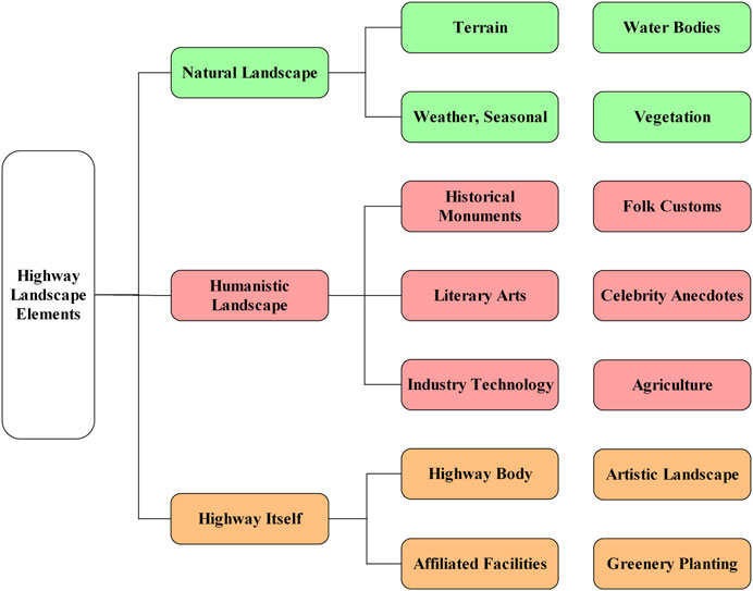
FIGURE 1. Highway landscape resource classification.
The highway is located in the open natural environment in the shape of a band, which belongs to the large-scale landscape elements. Natural landscape resources also belong to the large-scale landscape based on the highway. To observe the natural landscape resources along the line, with the band characteristics, the texture of the highway landscape and the background, the highway line layout, and landscape effect play a decisive role in the impact. Compared with the motorway and natural landscape resources, humanistic landscape resources belong to small-scale landscape resources and do not have continuity characteristics (Chen, 2005). The humanistic landscape has obvious regional characteristics and is the secondary landscape of the highway, through cultural symbolism, materialization, and other ways, to express some humanistic meaning, that continues and adds the mood and characteristics of different regions in the highway landscape system, which as a whole plays the role in the final touch.
The classification of landscape resources can identify problems in the aesthetic design of highway landscapes and avoid landscape design affecting the humanistic style or construction cost of transportation projects, clarify architectural features and detail issues, clarify the background of the landscape, determine the materials used in the project, colors, and color schemes, and better determine the appropriate landscape design theme to create a harmonious and natural highway landscape.
Figure 1 shows that the highway landscape is a microcosm of the geographical landscape in which it is located. The diverse natural landscape resources determine, to some extent, the composition of the highway landscape. For those roads that are longer and span more territories, the overall style of the road should be determined at the beginning of the landscape design. Then, according to the natural and human characteristics of the area, it is planned in sections to demonstrate the regional characteristics fully. Reasonable landscape segmentation can give the public a scenery and keep the concentration of attention to improve traffic safety while ensuring that the landscape features style. The following principles should be followed when planning segments of the highway landscape.
Based on ecological theory, we respect nature and protect it. Natural landscape resources are important for maintaining the region’s basic ecological processes and life support systems and preserving biodiversity. Once the natural landscape resources are damaged, it will be difficult to restore them. Therefore, natural landscape resources must be considered when determining the landscape unit of the highway corridor zone (Wang, 2011).
Comfort and safety are the main objectives of the highway landscape design and the basis for defining landscape sequence units. Studies have shown a close relationship between the driver’s perception during driving and the road landscape. The prerequisite for improving comfort is ensuring traffic safety. No matter how beautiful the landscape sequence of the road itself is, it becomes meaningless if traffic safety is not ensured. Therefore, ensuring traffic safety is the basis and prerequisite for designing landscape units along the highway corridor.
China’s highways range from a few dozen kilometers to several thousand kilometers and traverse more areas. Different regions of the natural landscape have different structures, patterns, and ecological processes. Therefore, when designing the sequence of landscape units in the highway corridor belt, we should plan in an integrated manner, design in sections, and make the landscape of the whole sequence unit coordinated according to local conditions. Furthermore, we should pay attention to the characteristics of each place, especially when crossing minority areas, and highlight the cultural characteristics of minority groups.
The highway is an organic whole, and attention should be paid to the coordination between the internal components when designing the landscape sequence so that they are organically integrated. Simultaneously, attention should be paid to the external coordination between the terrain and environment. When designing the alignment of the highway and the shape of the structures along the route, the wrong practice of cutting off the ecological environment space or visual landscape space should be avoided. There should be unity and continuity of attractions, ancillary facilities, and greenery along the route to avoid mutual independence and lack of overall coordination. At the same time, it should be coordinated with the local customs, history, and culture to show the local cultural connotation and flavor.
The highway landscape sequence design emphasizes the unity of each landscape design unit, but each landscape unit is not exactly the same, but to show their respective characteristics and flavor under the unified theme. Otherwise, the monotony of the landscape along the way leads to the sluggish attention of drivers. Appropriate changes in style, shape, color, linear bend, and undulation will make the driver feel the rhythm of the landscape along the way, versatility, and generate a pleasant psychological experience to eliminate fatigue to improve driving safety purposes. Therefore, the design of the highway corridor belt landscape unit must be under a unified theme, change in unity and unity in change (Wei et al., 2004).
The natural landscape resources along the highway corridor have a certain scale, and the divided landscape paragraphs cannot disrupt the sequential nature of the natural landscape along the route. Analyzing the aforementioned characteristics, the cluster segmentation of ordered samples in the cluster analysis method applies to the segmentation of road natural landscape resources.
Cluster analysis is a multivariate statistical analysis method that classifies samples according to the principle of “things cluster together.” First, a statistic (e.g., matching coefficient) is chosen to measure the similarity between two samples. Then, according to the degree of similarity, each analysis object is aggregated according to certain criteria, and the matching coefficient between the two analysis objects is calculated. If the larger value of the matching coefficient indicates that the two samples are more consistent, they can be classified into one category. Eq. 1 calculates the matching coefficient of the ith sample to the jth sample.
In the formula:
Combined with the natural landscape characteristics along the highway, the homogeneous landscape section after division may be as long as 10–40 km. Although the landscape features are obvious, drivers driving long distances, homogeneous landscape paragraphs, and easy-to-form driving fatigue are not conducive to driving safety. Selecting and designing suitable landscape nodes as stimulation points based on natural landscape segmentation is necessary to relieve driving fatigue and add driving interest.
Human landscape resources belong to a small-scale landscape. In addition to the physical landscape of each constituent structure of the highway itself, it also includes the virtual landscape of ethnic customs, history, and culture caused by regional differences. The virtual landscape is shown chiefly along the highway with the help of landscape vignettes. The point landscape of highways, such as bridges, cross-lane bridges, interchanges, service areas, and other virtual human landscape resources, obviously does not have a ribbon character. It is more reasonable to extract humanistic landscape nodes based on natural paragraph division and give connotation to landscape nodes with humanistic landscape resources along the route, highlighting the landscape theme. The landscape nodes are also fatigue stimulation points to relieve driver fatigue. Therefore, the node control method is proposed to determine the highway human landscape nodes and themes.
First, we should conduct a comprehensive and detailed investigation of the human landscape resources at the special landscape nodes along the highway. Then, the human materials along the highway that spans the region are organized, analyzed, and classified. Finally, based on the requirements of the overall planning of the highway landscape, the human landscape theme with regional characteristics is determined by integrating the selected cultural themes.
According to the identified humanistic landscape theme, the figurative humanistic themes are displayed in front of the road users through the use of landscape vignettes and other forms. If the human landscape sculptures are laid out on the highway, drivers do not have enough time to taste its wonders seriously. Only by applying unique regional characteristic elements to static landscape nodes, such as service areas, can the goal of showing regional human characteristics be achieved.
Cluster analysis is a general term for multivariate analysis techniques that classify the object of study according to its characteristics and is a quantitative analysis method that categorizes samples. The object to be usually analyzed requires a sufficiently large number of samples, and the samples are reasonably categorized according to different characteristics without providing a pattern for reference. The nodal control method is proposed because there is continuity and correlation between the developmental processes of things. Whether in time or space, the development process of things is uninterrupted, and there is an internal correlation between the processes, so it is very complicated to control the whole process of the development of things. With the extension of the route and being dynamic and along the route of natural landscape resources, the highway landscape segmentation planning and design become more complex, and only using a certain paragraph division method to get the division results is often unsatisfactory. Therefore, the integration of cluster analysis and node control method is proposed for the highway landscape paragraph division.
The highway landscape segmentation integrating natural landscape elements is mainly quantitative, but the segmentation integrating humanistic landscape elements is qualitative. Due to the differences between the angle of departure and the factors considered in the two methods, the conclusions drawn are also different, so in reality, landscape segmentation should be considered in both the natural landscape and the humanistic landscape elements. Therefore, it is necessary to make minor adjustments based on the preliminary segmentation results considering the natural landscape elements and then integrating the segmentation results of the humanistic landscape elements, as shown in Figure 2. The specific idea of this method is based on the characteristics of the roadside natural environment. The use of the cluster analysis method selected part of the natural landscape elements that will have an impact on the landscape of the highway and the initial segmentation of the highway, and the mileage of the paragraph should not be too long or too short; at the same time, the humanities along the way are selected as a number of regional characteristics of the nodes to adjust the results of the cluster analysis of the division of results, to arrive at the final segmentation of the program.
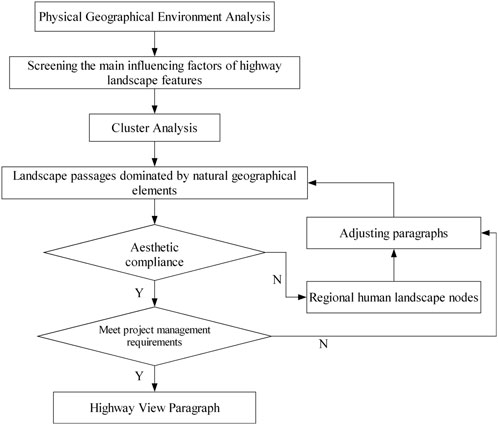
FIGURE 2. Clustering node control method.
The method considers the natural landscape elements and organically combines the humanistic landscape elements along the road. It can be perfectly integrated with local landscapes with regional characteristics to achieve the highway landscape’s best effect, alleviate road users’ visual fatigue, and provide a comfortable and beautiful traveling environment for drivers and passengers.
In the landscape paragraph division, due to the comprehensive consideration of the impact of natural landscape resources and human landscape resources, comprehensively refining the landscape resources within the road section, reflecting the natural and cultural characteristics of different geographical areas, is suitable for the construction of highway landscapes on both sides of the road with distinctive features of the topographic and humanistic conditions. Carefully taking safety driving, management and maintenance, and other factors into account, the critical threshold of the monotonous landscape highway length, that is, the road’s landscape paragraph length, generally should not be less than 10 km (Wei and Zhao, 2016), and, in this study, the unit length of the highway paragraph division is taken as 10 km to meet the traffic safety requirements.
Paragraph division should follow the overall design principles of landscape. The integration of regional characteristics and the national customs near the highway are fully refined and sublimated. Determining the landscape theme of each paragraph fully demonstrates the regional characteristics of the highway into a set of functional, environmental protection, and aesthetic characteristics of the landscape corridor belt.
Cluster analysis is based on the distance to measure the degree of affinity between cases or variables. Suppose there is a high correlation between the selected indicators of clustering variables, which can be substituted for each other, the same variables will repeatedly play a role in calculating the distance, equivalent to weighting these similar variables, which leads to the clustering results being biased in favor of the variable. The article makes the classification results more reasonable by taking two measures.
Before carrying out the cluster analysis, the presence of high correlation between the clustering indicators is tested. First, the cluster analysis is carried out on the highly correlated variables and then a representative variable is selected from the clustering results as the final clustering indicator. Then, the correlation coefficient between the clustering indicators is calculated by correlation analysis to determine whether there is a covariance problem and to ensure the accuracy of the clustering analysis.
Simultaneously, we define the error function: if the analyzed samples are clustered into n classes, the sum of the diameters of the n classes is the minimum, which is the minimum loss function.
When (n, k) is fixed, the smaller
Dividing landscape paragraphs is based on natural landscape resources. Combining the highway’s landscape elements to determine the location of the landscape nodes is set to relieve driving monotony fatigue. It is also necessary to assess the historical, humanistic, and economic landscape resources along the highway corridor belt and give the landscape paragraphs a theme, so that the landscape elements at different landscape nodes within the same paragraph have the same theme. The paragraph’s theme is highlighted to avoid the same paragraph’s theme within the landscape elements with varying variety due to the heavy information that led to driving fatigue.
The theme of the corridor belt landscape should be distinct. The proposed landscape theme should be based on the investigation and analysis of the road environment and the system’s regional characteristics to create a unique highway landscape with solid regional characteristics. The thematic composition of the landscape paragraphs is shown in Figure 3.
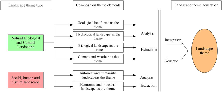
FIGURE 3. Diagram of the landscape paragraph theme composition.
The process of determining the theme of the highway view paragraph mainly includes the following four stages. The thematic design process of the landscape paragraphs is shown in Figure 4.
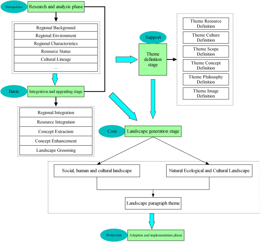
FIGURE 4. Flow chart of landscape paragraph theme design division.
The research and analysis stage is a prerequisite. This stage mainly involves site survey, data collection, and surrounding environment investigation in the highway located in a certain area, based on a systematic and comprehensive regional background of the highway, regional environment, regional characteristics, the current state of resources, cultural context, and other elements of a systematic and comprehensive analysis and research. The purpose of this stage is to collect first-hand information for the design of the theme of the landscape paragraph and the initial formation of the design idea framework and design concepts.
The integration and refinement stage lays the foundation for subsequent stages. This stage depends on the research and analysis stage through the systematic and comprehensive integration, research, and analysis of the first-hand information, the regional situation, and resource elements in the integration, targeted to propose the possible formation of landscape elements in the highway area to sort out. This stage analyzes the information for the understanding and mastering of the main landscape elements suitable for the landscape paragraph theme design. This stage focuses on the integration and enhancement of the first-hand information in the region to lay a good foundation for the next step in the thematic design of the landscape paragraphs.
The theme definition stage is the support stage. This stage defines the theme resources, theme culture, theme category, theme concept, theme idea, and theme image in the area where the road is located. Thematic resource is defined as the integration and enhancement of the brand and core resources of the area where the road is located. Thematic culture involves sorting of the distinctive cultural connotations of the region. Thematic category implies determination of the overall scope of the thematic design of the landscape passage, i.e., the leading landscape elements. Theme concept depends on the research and analysis, integration and upgrading, and the refinement of the main design concept with unique regional characteristics in line with the actual local situation. In short, this stage is an important stage of highway landscape planning, which solves the theme of the landscape paragraph, " what to design,” “how to design,” “design to what extent,” and other issues in the support stage.
The landscape generation phase is central. First, analyzing and studying the current situation of the area where the highway is located and integrating and upgrading the unique landscape elements and cultural connotations are sorted out. The core scope of the landscape paragraph theme design is determined, ranging from the social and cultural landscape to the natural ecological landscape. Second, under the guidance of the identified theme idea, with the regional cultural connotation, the unique style, style, color tone, spatial structure, and distribution of the landscape paragraph theme design are determined. Finally, designing of landscape elements is carried out (Yang, 2012).
The Zhunxing Highway is located in the southwestern part of the Inner Mongolia Autonomous Region, China, with a total route length of 265 km. The engineering area is located in the southern part of the Inner Mongolia Plateau. The landform types are mainly divided into three categories: Kubuqi Desert (eastern end) of the Ordos Plateau to the west of the Yellow River, low mountains and heavy hills to the east of the Yellow River, and inter-mountain basin plain area, with an elevation between 1,000 and 1,500 m. It can be divided into three sections from the administrative territory: the Erdos transit section, the Hohhot transit section, and the Ulanqab transit section. The project spans deserts, mountains, and plains. The division method of highway landscape corridor zone paragraphs is shown in Figure 5.
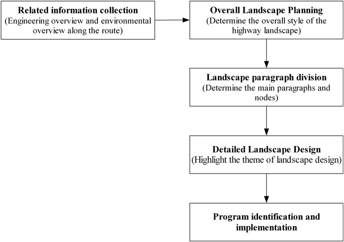
FIGURE 5. Steps involved in highway landscape paragraph division.
When considering natural landscape resources, physical conditions, including soil types, topographic features, vegetation types, vegetation cover, and rivers and lakes, are mainly visible within the visual range. Rivers and lakes have distinct human colors due to human activities, so they should be combined with human landscapes when considered. Therefore, it is necessary to focus on the influence of the first four factors when selecting classification indicators.
Through the investigation of the site conditions along the Zhunxing Highway, a study was conducted to analyze the changes in four natural elements based on the soil type, topography, plant cover, and plant type along the entire route. The topography along the route mainly includes deserts, hills, and basins, except for the starting point of the desert and the Daihai Basin and the Huangqihai Basin, which are hilly, taking into account that the proportion of hilly terrain is large and the degree of undulation varies and can be classified into small undulating hills, large undulating hills, and gently sloping hills. The soil types mainly include sandy soils, gray–brown soils, brown soils, brown soils, chestnut soils, calcium chestnut soils, salty soils, swamp soils, and grassy meadows soils. Vegetation types include sandy vegetation, sheep steppe vegetation, fescue grassland, and farmland, which are divided into arid and normal farmland according to the degree of fertility. Vegetation cover was divided into three levels according to the relative degree of cover: high cover, medium cover, and low cover. The clustering indicators are defined as shown in Table 1.
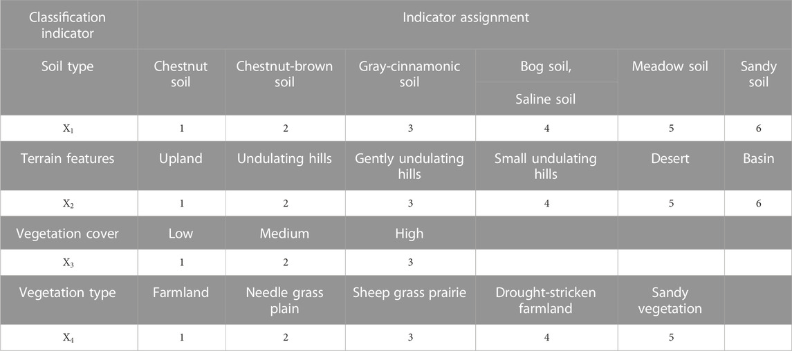
TABLE 1. Cluster analysis index assignment.
According to the research results, the aforementioned four natural elements within 10 km of the area the project passes have a relatively small degree of variation. So, considering 10 km as a segment unit, the 265-km-long Zhunxing Highway can be temporarily divided into 26 natural segments. The natural factors for each segment are categorized as shown in Table 2.
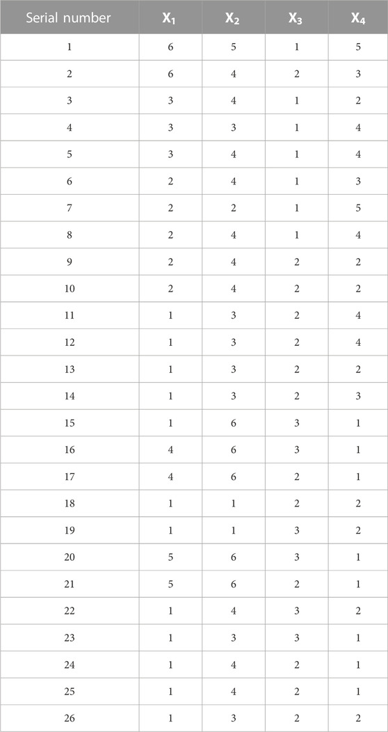
TABLE 2. Classification table of natural factors of the Zhunxing Highway.
Since the
The calculation of this formula does not consider the number of values of the scalar variables in each category without discrimination, so the size of
where
Usually, two categories of road sections with the same or similar natural elements are first considered for grouping. Then, a matrix of matching coefficients with higher similarity is calculated to cluster the neighboring road sections. Since there are four classification indicators, two or more similar indicators are assumed to be classified as the same category (similarity reaches more than half). From the weighting factor 6,6,3,5, it follows that if there are no less than two similarities between samples, their similarity should not be less than 8. The corresponding partitioning rule can be derived, that is, the partitioned matrix cannot contain matching coefficients less than 8. The adjacent matrix blocks are then analyzed to obtain the corridor zone delineation based on natural ecological factors, as shown in Table 3.
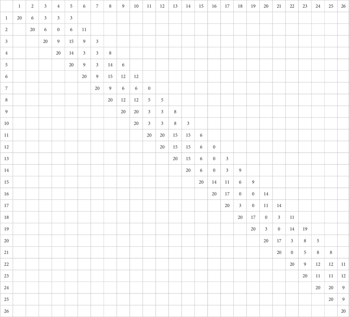
TABLE 3. Matrix of categorization of the results of the calculation of the matching coefficient.
The final segmentation results based on natural ecological factors are obtained and shown in Table 4.
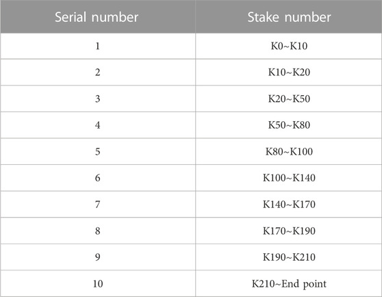
TABLE 4. Results of natural ecological factor classification in the corridor zone.
The Zhunxing Highway extends from east to west along the route through three cities. The three cities cover Jungar Banner, Qingshuihe County, Horinger, Liangcheng County, Fengzhen County, Chahar Right Front Banner, Xinghe County, and seven other counties (banners and cities), as shown in Table 5. The artificial structures are mainly large bridges, interchanges, and service areas. The main bridge is the Yellow River Bridge, with a total length of 2,389 m. There are nine interchanges along the route and three main service areas: Dahongcheng Service Area, Liangcheng Service Area, and Tuguula Service Area, as shown in Table 6. Based on the human history of the administrative area through which the route passes, the regional nodal control is used to obtain a corridor zone division based on the human landscape nodes using the stakes of the structures for control.
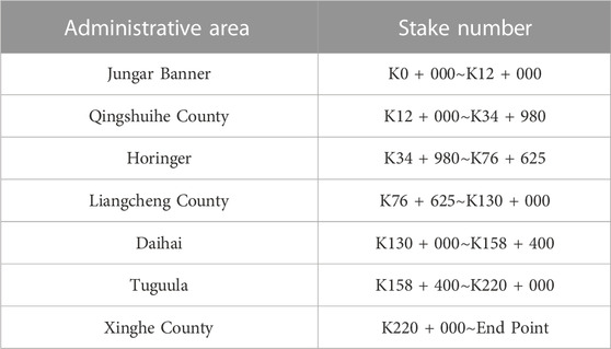
TABLE 5. Humanistic landscape corridor zone division.
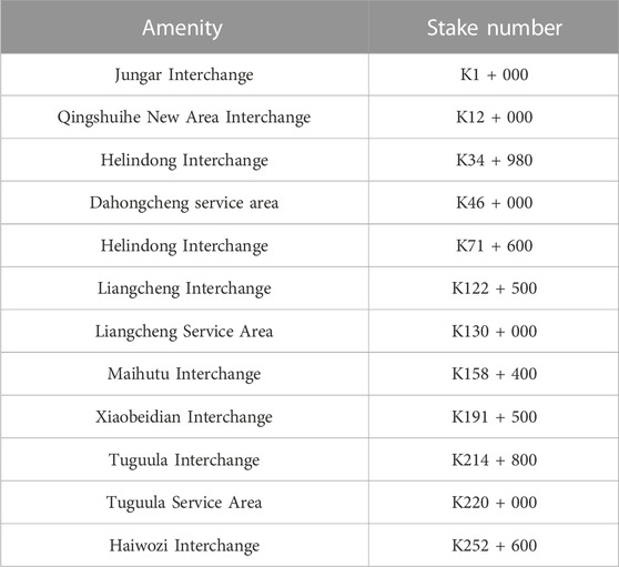
TABLE 6. Service areas and interchanges along the Zhunxing Highway.
The results of the cluster analysis division incorporating natural landscape elements ignore the human landscape of the region, and the application of the nodal method only considers human landscape elements and ignores the importance of natural landscape elements. The segmentation design by the natural landscape segmentation method based on regional natural landscape elements is then adjusted according to the essential landscape nodes along the highway to get the final division results. According to the region’s natural landscape and human landscape characteristics along the Zhunxing Highway, the clustering node control method introduced in this paper can divide the whole Zhunxing Highway into the following six paragraphs, as shown in Figure 6.
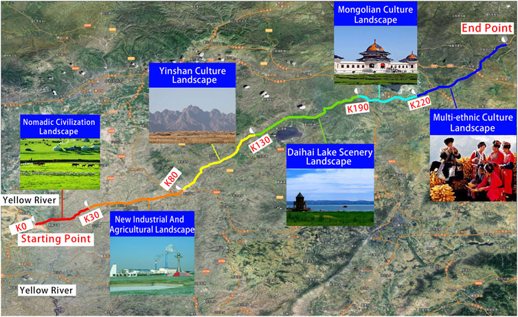
FIGURE 6. Zhunxing Highway landscape corridor with paragraph division.
The landscape theme of each section is designed in conjunction with the sectioning scheme.
1) Nomadic civilization landscape section theme (K0 + 000∼K30 + 000): The fertile land here is full of vicissitudes, and the Yellow River stretches for thousands of miles like a rainbow going through the sky. Green, as the dominant color, fully demonstrates the grassland style.
2) Landscape theme of the new industrial and agricultural landscape section (K30 + 000∼K80 + 000): In the distance, green grass is connected to the sky, and the Shengle Industrial Park shows its achievements. The core of the corridor is well-developed in industry and agriculture, and the landscape design theme can fully demonstrate the fruits of modern industrial and agricultural civilization.
3) Yinshan cultural corridor landscape theme (K90 + 000∼K140 + 000): Galloping side of Yinshan Mountain, stamp one’s name on the page of history. The landscape section passes through Liangcheng County, which is rich in humanistic landscape resources. The landscape design theme should fully demonstrate the cultural characteristics of the foot of Yinshan Mountain.
4) Daihai scenery landscape section theme (K130 + 000 ∼ K190 + 000): Take the color of the landscape, and listen to the lake breeze. The core of the corridor has Daihai and the natural scenery of the southern foot of Yinshan; the theme of this section of the landscape should show the color of the mountain and water.
5) Mongolian cultural corridor landscape theme (K190 + 000∼K230 + 000): Herders shepherd their sheep in the boundless grasslands, and the herders’ songs intoxicate the steeds. There are a large number of Mongolians living in this passage, and the landscape design theme should fully reflect the characteristics of the Mongolian civilization in the steppe.
6) Multi-ethnic cultural landscape section theme (K220 + 000∼End point): Remembering the Great Years and seeing the circle of the nine states. The landscape section is at the junction belt of three provinces, belongs to the minority settlement area, and is the key section of economic and cultural integration. The landscape theme should reflect multi-ethnic cultures’ great integration, economic cooperation, cultural integration, and national unity (Yang, 2012).
The landscape design of the Zhunxing Highway analyzes the natural and humanistic landscape resources of the region where the project is located, determines the objectives and principles of the landscape design of the project, divides the whole highway into sections according to the regional characteristics of the route, determines the landscape theme of each landscape section, draws up the landscape design points of some control nodes, effectively improves the phenomenon that the landscape of the Zhunxing Highway is too single, and highlights the regional cultural characteristics. The texture of the highway, adapted to the needs of the new period of highway construction, the Zhunxing Highway, is enhanced to create a safe, comfortable, efficient, and beautiful environment for the highway. The diversity of landscape themes keeps drivers in a better state of mind and can guarantee the operational safety of motorways.
This paper proposes the concept of highway landscape segmentation planning considering regional characteristics, constructs a highway landscape segmentation process, introduces the statistical method of cluster analysis, divides the landscape sample units without disturbing the sequence of natural landscape resources along the highway corridor belt, establishes the landscape cluster analysis matrix, selects the clustering results as the preliminary natural landscape segments, and enriches the highway segmentation system. Through an on-site field survey and network survey, the ecological landscape and historical and cultural background of the proposed project were investigated. The existing resources were assessed, and based on the analysis results, the methods of landscape background treatment and landscape theme determination were proposed, highlighting the highway landscape theme and giving cultural connotations to the landscape nodes. The characteristics of each landscape section were analyzed, the landscape design theme and design points of each section were proposed, and based on the overall landscape planning, the landscape of each corridor belt was themed and design proposals were made. This study improves the phenomenon that the highway landscape design is too single at the present stage, and the proposed landscape paragraph division and design theme enrich the highway landscape design method to a certain extent, providing a new method for the construction of highway natural landscape and humanistic landscape, and enrich the content of highway landscape.
This paper puts forward the highway landscape paragraph division and determines the landscape theme of the method. According to the regional characteristics of the road landscape, segmentation planning and design principles, content, methods, and standards are still in the primary stage of development. Refinement of the elements can reflect the cultural system characteristics of the region through which the road passes is the key to humanistic landscape design. Because the region through which the road passes is a linear region, it is not known whether the local people and road users can recognize the refinement of regional cultural elements, and the refinement of the elements of cultural landscapes is a subject that needs further research.
The original contributions presented in the study are included in the article/Supplementary Material. Further inquiries can be directed to the corresponding author.
Conceptualization, SH, GH, and HX; methodology, SH and GH; formal analysis, SH and GH; writing—original draft preparation, SH and GH; writing—review and editing, SH and GH. All authors contributed to the article and approved the submitted version.
The authors would like to acknowledge the support of the Key Scientific Research Project Plan of Henan Universities (Project No. 20a580003). The authors would like to thank the Scientific Research Project (Project No. 2022-002) of Electric Engineering Company of the China Railway Seventh Group, China Railway Seventh Power (Science and Technology). The authors would also like to thank the colleagues in the project team who dealt with a large amount of data.
HX was employed by Electric Engineering Company of the China Railway Seventh Group.
The remaining authors declare that the research was conducted in the absence of any commercial or financial relationships that could be construed as a potential conflict of interest.
The authors declare that this study received funding from Electric Engineering Company of the China Railway Seventh Group. The funder had the following involvement in the study: Concept development and design.
All claims expressed in this article are solely those of the authors and do not necessarily represent those of their affiliated organizations, or those of the publisher, the editors, and the reviewers. Any product that may be evaluated in this article, or claim that may be made by its manufacturer, is not guaranteed or endorsed by the publisher.
Bai, H., Luo, H., and Li, W. (2022). Landscape optimization of expressway cutting slope considering driver safety and visual characteristics. China J. Highw. Transp. 35, 273–282.
Chamberlain, B., and Meitner, M. (2013). A route-based visibility analysis for landscape management. Landsc. Urban Plan. 111, 13–24. doi:10.1016/j.landurbplan.2012.12.004
Chen, B. (2019). Research on the driver’s visual load caused by mountainous road landscape. Master's thesis. Chongqing, China: Chongqing Jiaotong University.
Chen, F. (2009). The impact of road visual environment on traffic safety. Master's thesis. Chongqing, China: Chongqing Jiaotong University.
Chen, J. (2005). Systematic research on expressway landscape. Master's thesis. Wuhan, China: Wuhan University of Technology.
Chen, J., Zhu, C., Li, L. P., Sun, Z. y., and Pan, X. b. (2007). Effects of exogenous salicylic acid on growth and H2O2-metabolizing enzymes in rice seedlings under lead stress. Transp. Constr. Manag. 302, 44–49. doi:10.1016/s1001-0742(07)60007-2
Chen, Y., and Guo, L. (2008). Relationship between layout-angle of expressway landscape picture and its assessment. J. Tongji Univ. Nat. Sci. 03, 339–343.
He, Y. (2017). Design and evaluation of the forest belt of highway ecological landscape. Master's thesis. Guangzhou, China: South China University of Technology.
Hu, S. (2011). Study on the freeway landscape planning and design Technology. Ph. D. Dissertation. Xi’an, China: Chang’an University.
Hu, S., Tong, W., and Mao, K. (2023). Study on highway landscape environment assessment and grading method. Sustainability 15, 4904. doi:10.3390/su15064904
Jacques, B., and Martin, P. (2014). Relationships between frequency of driving under the influence of cannabis, self-reported reckless driving and risk-taking behavior observed in a driving simulator. J. Saf. Res. 49, 19.e1–24.
Jeong-Hun, M., Harlow, C., and Jody, R. (2003). “Comparison of safety performance of urban streets before and after landscape improvements,” in 2nd urban street symposium (Anaheim, California: NACT), 2.
Jin, G., Peng, J., Zhang, L., and Zhang, Z. (2023). Understanding land for high-quality development. J. Geogr. Sci. 33, 217–221. doi:10.1007/s11442-023-2079-9
Karlson, M., Caroline, S., Mörtberg, U., Olofsson, B., and Balfors, B. (2016). Design and evaluation of railway corridors based on spatial ecological and geological criteria. Transp. Res. Part D Transp. Environ. 46, 207–228. doi:10.1016/j.trd.2016.03.012
Li, Y., Chen, F., and Jiang, D. (2019). Research on highway landscape design based on regional culture. IOP Conf. Ser. Earth Environ. Sci. 330, 022046. doi:10.1088/1755-1315/330/2/022046
Lin, X. (1996). Road construction and environmental protection act of the former Federal Republic of Germany. J. China and Foreign Highw. 06, 15–17.
Moser, P. (1972). Aesthetic and ecological disharmonies of highways. Transportation 1, 55–67. doi:10.1007/bf00167508
Qin, X., Fang, M., Yang, D., and Wangari, V. W. (2023). Quantitative evaluation of attraction intensity of highway landscape visual elements based on dynamic perception. Environ. Impact Assess. Rev. 100, 107081. doi:10.1016/j.eiar.2023.107081
Ruan, Y., Qin, X., and Wang, R. (2020). Study on the quantitative method of Yunnan Xishi expressway based on the landscape characteristics of expressway road area. J. Highw. Transp. Res. Dev. 16, 366–369.
Sarah, G., Steven, M., and Hubert, G. (2009). The dual role of roads in the visual landscape: A case-study in the area around mechelen (Belgium). Landsc. Urban Plan. 92, 125–135. doi:10.1016/j.landurbplan.2009.04.001
Su, E., Zhang, X., Wen, X., Liu, J., Ye, F., Han, X., et al. (2023). Visual characteristics of drivers in different directions and lengths of gradual landscape zones in extra-long highway tunnels. Tunn. Undergr. Space Technol. 137, 105136. doi:10.1016/j.tust.2023.105136
Su, Z., Zheng, S., and Yang, Y. (2016). Dynamic visual features of drivers and creation of landscapes on expressways in mountainous area. Technol. Highw. Transp. 32, 140–144.
Tang, Z. (2008). Research on harmony between expressway and landscape along the route. Ph. D. Dissertation. Beijing, China: Beijing Forestry University.
Wang, R. (2011). Study on the freeway landscape partition planning. Master's thesis. Xi’an, China: Chang’an University.
Wang, R., and Wang, Z. (2013). “Assessment model for high-way landscape maintenance based on analytic hierarchy process,” in Proceeding of the 4th international conference on transportation engineering (ICTE) (Beijing: ICTE), 569–574.
Wei, Z., Wang, S., and Ren, F. (2004). Research on landscape sequence composition of high-grade highway. J. Highw. Transp. Res. Dev. 21, 134–137.
Wei, Z., and Zhao, X. (2016). Critical threshold of highway length under monotonous landscaping patterns. J. Beijing Univ. Technol. 42 (01), 95–106.
Yang, C. (2012). Landscape design of highway that integration of regional humanities. Ph. D. Dissertation. Xi’an, China: Chang’an University.
Yang, H. (2022). Study on highway landscape based on the regional characteristics of henan province. Master's thesis. Zhengzhou, China: Henan University.
Zhang, D. (2016b). Research on the mechanism of the landscape in highway for the safe driving in mountain areas. Master's thesis. Chongqing, China: Chongqing Jiaotong University.
Zhang, K. (2016a). Highway landscape planting design based on the traffic safety. Master's thesis. Xi’an, China: Chang’an University.
Keywords: traffic safety, highway view, landscape corridor belt, landscape unit, landscape theme
Citation: Hu S, He G and Xu H (2023) Research on the segmentation method of a highway landscape corridor zone. Front. Environ. Sci. 11:1212264. doi: 10.3389/fenvs.2023.1212264
Received: 05 May 2023; Accepted: 29 August 2023;
Published: 13 September 2023.
Edited by:
Mohamed A. E. AbdelRahman, National Authority for Remote Sensing and Space Sciences, EgyptReviewed by:
Sepideh Baghaee, Polytechnic University of Madrid, SpainCopyright © 2023 Hu, He and Xu. This is an open-access article distributed under the terms of the Creative Commons Attribution License (CC BY). The use, distribution or reproduction in other forums is permitted, provided the original author(s) and the copyright owner(s) are credited and that the original publication in this journal is cited, in accordance with accepted academic practice. No use, distribution or reproduction is permitted which does not comply with these terms.
*Correspondence: Guoqi He, aGljaWgxOTk3QDE2My5jb20=
Disclaimer: All claims expressed in this article are solely those of the authors and do not necessarily represent those of their affiliated organizations, or those of the publisher, the editors and the reviewers. Any product that may be evaluated in this article or claim that may be made by its manufacturer is not guaranteed or endorsed by the publisher.
Research integrity at Frontiers
Learn more about the work of our research integrity team to safeguard the quality of each article we publish.