 Zhiwei Zeng
 Hua Yang4*
 Qianfu Ji
 Qimeng Ning
95% of researchers rate our articles as excellent or good
Learn more about the work of our research integrity team to safeguard the quality of each article we publish.
Find out more
ORIGINAL RESEARCH article
Front. Environ. Sci. , 09 June 2023
Sec. Environmental Informatics and Remote Sensing
Volume 11 - 2023 | https://doi.org/10.3389/fenvs.2023.1200513
This article is part of the Research Topic Territorial Spatial Evolution Process and its Ecological Resilience View all 15 articles
The territorial spatial planning in the new era strengthens the control of different functional spaces and emphasizes integrated and coordinated development of each functional space. Therefore, it is important to monitor the “structure-function” characteristics of water-ecological space based on the context of territorial spatial planning and develop a management and control framework. Based on land use and social statistics, and with the help of ArcGIS analysis, this paper examined the structure and function of the water-ecological space in the Dongting Lake study for 2010, 2015, and 2020, generating a control framework and proposing key initiatives. The main results are as follows: 1) The overall scale of the water ecological space in the Dongting Lake study is over 7,300 km2. Water bodies had the largest share, followed by coastal terrestrial areas, while the land-water ecotone was the smallest. There was a small decrease in the water ecological space during the study period. Yueyang had the largest overall scale of water ecological space, while Linli had the smallest. 2) The comprehensive function of water ecological space in the Dongting Lake study was about 0.4000, increasing somewhat during the study period. Among the units, the comprehensive function value was highest in Yuanjiang City, while Jincheng City had the lowest. 3) From the structural elements of water ecological space, scientific planning of functional zoning of water ecological space should be carried out and combined with the delineation of “three zones and three lines.” Key initiatives such as multi-scale and multi-level planning and control, use control and access restrictions, determination of water ecological space ownership, pollution control and accountability, and comprehensive water ecological treatment and restoration should be promoted.
Water ecological space pertains to areas that provide for hydrological-ecological processes, maintain the health and stability of water ecosystems, and guarantee water security; as a core constituent of ecological space and the basic support of urban space and agricultural space, it has an important position in the national spatial system (Yang et al., 2017a; Zhu et al., 2017). However, rapid urbanization and industrialization have caused damage to the water ecological environment. Regional water shortage, water pollution, flooding, and other water-related problems frequently occur, leading to enormous pressures on the water ecological space (Yang et al., 2021). Therefore, under the new territorial spatial planning system, mapping the dynamic evolution of regional water ecological space and enhancing the control and management of regional water ecological space are essential measures to implement territorial spatial use control, optimize territorial spatial layout, and enhance territorial spatial quality, in order to promote high-quality regional development.
Monitoring and control of water-ecological space is to measure and collect data on the real-time status of water spatial structure, hydrology, aquatic biology, water quality, water function and other elements, analyze and evaluate the status quo and development trend of water ecosystem on this basis, and propose corresponding regulation and control measures, with the purpose of protecting and restoring water ecological environment. It is the foundation of water ecosystem protection, management and sustainable utilization in the new era (Liu et al., 2022). Domestic and foreign scholars have explored the monitoring and control of water ecological space. Foreign researchers have had an early start, focusing mainly on water quality monitoring (Aina et al., 2015), water ecological habitat (Cecilia et al., 2016), water resource management (Chitresh et al., 2017), and water environment management (Gerald and Galloway, 1997), and attaching importance to the relationship between land use and water ecological space and its impact effect (Ghosh and Maiti, 2021; Baltodano et al., 2022). For example, Benra et al. (2021) used the InVEST model to monitor the service value of the water ecosystem. Alberti et al. (2006) found a clear correlation between the water ecosystem and urban land use structure (Marina et al., 2006). Gerald et al. analyzed the Mississippi River flood in 1993 and proposed a sustainable water space management model that integrates environment, economy and culture. Over time, a systematic paradigm of “classification system-evolution characteristics-control measures” was gradually established in water ecological space research.
Combining international research on water ecological monitoring and control concepts and methods with China’s own land ownership, space development, and environmental management systems, domestic scholars have explored traditional water quality detection (Yin et al., 2021) and water resource management (Zuo et al., 2021), expanding into water ecological space classification (Li et al., 2009) and control planning systems (Wu et al., 2021). And with the establishment and improvements in territorial spatial planning, water ecological space classification has gradually become a research hotspot. Local scholars have largely focused on the spatial causes, composition media, and spatial forms of the classification criteria (Deng et al., 2004; Liu C. et al., 2018; Kang et al., 2022). For example, Huang et al. (2012) proposed a zoning method for water ecological space based on regional differences in river basin water ecosystems. Yang et al. (2017b) and Yang et al. (2017c) defined the scope of water ecological space into three types: water ecological protection red line study, water ecological restricted development study, and water security guidance study.
The current concept of water ecological space control and related studies are based on extending the idea of land use control. Research has been conducted in terms of control zones, control systems, and control indicators (Du et al., 2013; Qiu et al., 2017). For instance, Cao et al. (2014) used current ecological elements, important rivers, lakes, reservoirs, wetlands, and green parks and proposed the water ecological control standards for water ecological space. Qiu et al. (2017) explored and analyzed the water ecological space control system based on the supporting requirements of water ecological space. Other studies have analyzed the spatial evolution of the water ecological environment (Su et al., 2021), the water ecological effects of land use and urban activities (Ren et al., 2016), and water ecological civilization (Jiang et al., 2018). In general, domestic and international research on spatial monitoring and control of water-ecology is developing from small to large scales (Yin et al., 2021).
According to system theory, water ecological space can be regarded as a water-centered eco-economic system formed by the interaction of natural and human elements disturbed by human activities; its structure and function are the most fundamental attributes of the system (Liu et al., 2010; Liu W. et al., 2018). Structure reflects the external form of water ecological space, while function harbors its internal role (Bo et al., 2022). Therefore, understanding the dynamic change process and characteristics of the structure and function would be crucial in protecting and optimizing water ecological space and integrating and coordinating national space. The impact of urbanization, population growth, industrial and agricultural production and FDI on changes in the spatial scale of water and ecology has been investigated (Zhou et al., 2022a; Wei et al., 2023), and the relationship between the optimization of water and ecological functions and the coordination of national spatial functions has been discussed (Ouyang et al., 2022). However, there is a paucity of literature on the study of water ecological spaces from an integrated “structure-function” perspective. Most are based on specific management purposes (Zuo et al., 2021), often overlooking the perspective of new territorial spatial planning. Their results are decoupled from the new planning system, which is not conducive to the practical operations of territorial spatial zoning, use control, and optimal management. Therefore, based on the new territorial spatial planning context, it is necessary to monitor the regional water ecological environment from the perspective of “structure-function” and explore feasible control strategies for regional territorial spatial planning.
The study area is Dongting Lake, which is the ecological security lifeline of the Yangtze River basin. It is an important storage lake ecological zone in the middle and lower reaches of the Yangtze River, which is a typical fragile zone of interlocking water and land ecology (Chen et al., 2013; Ning et al., 2020). Due to accelerated urbanization, industrial and agricultural activities around Dongting Lake have increased, intensifying land use and damaging the water ecosystem. The region’s water areas have shrunk considerably, soil erosion has become common, flooding is frequent, and the water ecological environment has shown a declining trend (Liu and Wang, 2008; Chen Q. et al., 2015). As an important hub of Hunan Province’s “one belt, one city” strategy, the protection and construction of Dongting Lake’s water ecological space are closely linked to the high-quality development of the province and the Yangtze River Economic Belt. The main scientific question that this study focuses on is how to scientifically and effectively monitor the water and ecological space in the Dongting Lake area in the context of the new territorial spatial planning and the “structure-function” perspective? How to build a reasonable control strategy? This is also the main objective of this study.
The study area is a watershed unit centered on Dongting Lake, transitioning to plains, tablelands, and low hills (Deng et al., 2019). It is located in the northern part of Hunan Province at the confluence of the Xiangjiang, Zijiang, Yuanjiang, and Li rivers and has important hydrological regulating and agricultural production functions in the middle and lower reaches of the Yangtze River (as shown in Figure 1). Most of the study area is at an altitude of 30–50 m, belonging to the subtropical monsoon climate. While the Dongting Lake study site has a dense river network and abundant water, gas, soil, and biological resources, it has significant ecological vulnerability and sensitivity. Given the sharp contradiction between human activities and the water ecological environment (Wang and Tang, 2015), analyzing the monitoring and control system of water ecological space would be of great significance. Nineteen counties (cities, districts) closely related to the Dongting Lake Basin comprised the study site: Yueyang, Changde and Yiyang (Yueyanglou District, Junshan District, Yunxi District, Wuling District, Dingcheng District, Heshan District, Ziyang District) and Yueyang County, Huarong County, Xiangyin County, Miluo City, Linxiang City, Hanshou County, Anxiang County, Lixian County, Linli County, Jinshi City, Nanxian County, Yuanjiang City. The municipal districts of Yueyang, Changde, and Yiyang were each treated as an overall study unit, resulting in a total of 15 study units established for this study.
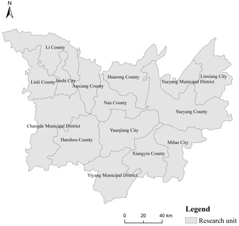
FIGURE 1. Overview of the study area.
Water ecological space is a vast and intricate system that includes not only bodies of water like lakes, rivers, and reservoirs but also water-land transitional zones like wetlands and mudflats, as well as terrestrial territorial systems close to the shore, which act as its structural components (Yang et al., 2017b). Meanwhile, it is also an important part of the regional landscape structure and a fundamental element of the regional landscape ecosystem (Zhou et al., 2022b). Given the diverse spatial structure, the water ecological space has both natural and human attributes (Tang et al., 2020), providing important values for the health and stability of natural ecosystems (e.g., water containment, soil conservation, and biodiversity maintenance) and fundamental carrying and supporting services to human development, including water supply, flood control and storage, and aquaculture (Zhou et al., 2020a).
Therefore, based on the structural elements and functional attributes of water ecological space, and considering data availability and the regional characteristics of the Dongting Lake water ecological space, three structural monitoring indicators (i.e., water space, water-land ecotone and coastal terrestrial) and three functional monitoring indicators (i.e., ecological function, social function, and economic function) were used in constructing the “structure-function” monitoring system of the aquatic biological space. Among the structural monitoring indicators, rivers/canals, lakes, and reservoirs/ponds were used for water spaces, mudflats and swamps were used for the water-land mosaic zone, and open woodlands were used for the shoreline terrestrial zone. For functional monitoring, water conservation was selected as an ecological indicator, reservoir pond area and bank length were used as social indicators, and fish production and fishery output value were selected as economic indicators. The specific index system is shown in Table 1.
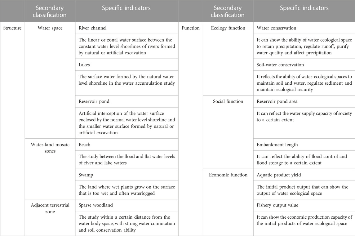
TABLE 1. Indicator system for “structure-function” monitor of the water-ecological space in the Dongting Lake study.
Soil and water conservation are basic ecosystem service value components of water ecological space (Li et al., 2011). Water conservation and soil-and-water conservation are used in this paper to describe the ecological function of the water ecological space in the Dongting Lake study area. The value of ecosystem services is frequently evaluated using the equivalent factor method in both local and international research. Ecosystem service value refers to the proportional value a specific service contributes to an ecosystem and is typically converted using the market price of grain output per unit (Chen Y. et al., 2015). Based on the research findings of Costanza et al., Xie et al. (2003) created an equivalent table of ecosystem service value in China. However, due to the large regional differences, the service value of the same ecological type may vary significantly in different regions and may require corrections to the national equivalent factor coefficient. Based on the equivalent factor table developed by Xie Gaodi et al. and referring to the results of Deng et al. (2019), this paper evaluated the service value coefficient for water conservation and for soil and water conservation of different water ecological space types in Dongting Lake (Table 2). The calculation formula for the ecological function value is:
where
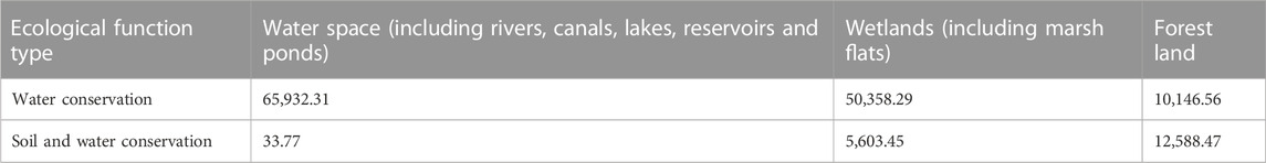
TABLE 2. The coefficients of ecosystem service value for various water-ecosystem spaces in the Dongting Lake study (yuan·hm-2*a-1).
Social and economic functions support and promote the water ecological space for human economic production and social activities. Using statistical data, the extreme difference standardization method was used on the social and economic indicators. Since the related indicators were all positive, the standardization formula is:
where
The final values for the social and economic functions were obtained using the weighted average method. The weight setting of each relevant index was determined by the entropy weight method. The calculation formula of the entropy weight method is:
where
The main data used in this study include basic geographic data, land use data and social statistics. Among them, the base map of the basic geographic data was obtained from the National Standard Map Service Platform (http://bzdt.ch.mnr.gov.cn/) with the review number GS (2019) 3333. The land use data was obtained from the Resource and Environment Science and Data Centre, Institute of Geographical Sciences and Resources, Chinese Academy of Sciences (https://www.resdc.cn/), classified with reference to the LUCC classification standard, and spatially analysed in ArcGIS. Social statistics such as length of embankments, fish production and fishery output value were obtained from the Hunan Statistical Yearbook and statistical bulletins of the relevant years.
The water ecological space of the Dongting Lake area is more than 7,300 km2, accounting for about 28.35% of the total land area. During the study period, the total aquatic ecological space decreased slightly from 7,390.81 km2 in 2010 to 7,350.99 km2 in 2020, a decrease of 39.82 km2. Among the aquatic ecological space types (Figure 2), water area accounted for the largest proportion but decreased significantly during the study period. Water ecological space decreased from 3,772.41 km2 (51.04%) in 2010 to 3,470.19 km2 (47.21%) in 2020, a decrease of 302.22 km2. The largest decrease occurred in 2010–2015, with a total decrease of 272.41 km2. The land-water ecotone accounted for the smallest proportion but showed a clear upward trend during the study period. Aquatic ecological space increased from 1,597.86 km2 (21.62%) in 2010 to 1,895.81 km2 (25.79%), an increase of 297.95 km2; the growth was largest during 2010–2015, increasing by 280.03 km2. Coastal terrestrial areas comprised 27.00% of aquatic ecological space, decreasing by only 35.55 km2 during the study period, from 2,020.55 km2 in 2010 to 1,985.00 km2.
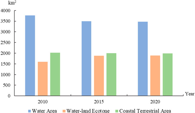
FIGURE 2. Changes in the spatial structure of water ecology in the Dongting Lake region from 2010 to 2020.
In terms of water space, the lake area was the largest, occupying more than 45%. Total lake area decreased from 1,901.74 km2 (50.41%) in 2010 to 1,604.14 km2 (46.23%) in 2020, a decrease of 297.60 km2; the fastest decline occurred during 2010–2015. Reservoir pond was the second largest, increasing from 31.45% to 34.21% during the study period. The spatial area slightly increased by 10.83 km2 during 2010–2015, then slightly decreased in 2015–2020, but the overall change was not pronounced. The proportion of the river channel was relatively low, accounting for about 680.00 km2 (19.00%); the change in the area and proportion for river channels was low for the given study period.
In the aquatic-terrestrial ecotone, swamps accounted for more than 50%, with a spatial area of more than 950.00 km2. During the study period, the proportion of swamps decreased from 60.13% to 50.24%, while its spatial area changed little. The proportion of beach land was relatively small but exhibited a significant upward trend during the study period. The proportion increased from 39.87% to 49.76%, while the area increased from 637.09 to 943.38 km2. The areas for the different types of water ecological space in Dongting Lake are summarized in Table 3.
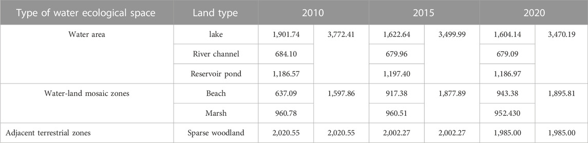
TABLE 3. Area of different types of water-ecological space in the Dongting Lake region from 2010 to 2020.
From the perspective of regional units, the water ecological space in the Dongting Lake area has prominent structural differences (Figure 3). As shown in Figure 3, the water ecological spaces in Yueyang County and Yuanjiang City were larger than 1,000 km2. Water ecological spaces in Yueyang County and Yuanjiang City were 1,332.98 and 1,327.99 km2 in 2010, 1,323.92 and 1,038.45 km2 in 2015, and 1,043.94 and 1,043.43 km2 in 2020. The scale of water ecological space in Xiangyin County, Hanshou County, and Li County was in the second echelon, having an overall scale between 500 and 1,000 km2. In 2010, the water ecological spaces in Xiangyin County, Hanshou County, and Li County were 735.08, 731.52, and 728.04 km2, 656.17, 659.65, and 659.16 km2 in 2015, and 522.74, 521.33, and 521.32 km2 in 2020. In other regional units (e.g., Yueyang City, Changde City, Linxiang City, Miluo City, Huarong County, Linli County, Anxiang County, Jinshi City, and Nanxian County), the water ecological space was below 500 km2. Linli County had the smallest overall scale, having a water ecological space area of 189.32 km2 in 2010, 188.09 km2 in 2015, and 187.57 km2 in 2020. During the study period, there was no significant structural difference in water ecological space in the Dongting Lake area, and the overall scale in each regional unit slightly fluctuated.
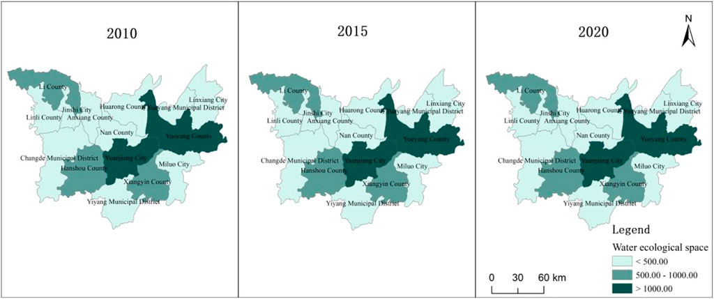
FIGURE 3. Regional Structural Differences in water-ecological Space in the Dongting Lake Region from 2010 to 2020.
For water space (Figure 4), Yueyang County and Yuanjiang City were larger, with water space areas of more than 400 km2. Yueyang County’s water space area was the largest but decreased significantly for the research period (762.54 km2 in 2010, 542.76 km2 in 2015, and 526.40 km2 in 2020), decreasing by 236.14 km2 in 10 years. Hanshou County, Xiangyin County, Huarong County, Nanxian County, Changde City, and Yueyang City followed, with water bodies between 200 and 400 km2; the change in water spaces in these areas was not significant for the study period. In seven regional units (e.g., Linli County, Miluo City, and Jinshi City), the water space scales were relatively small, with areas of less than 200 km2. Linli County had the smallest water area (about 40 km2) and exhibited no pronounced spatial change during the study period.

FIGURE 4. Regional structural differences of water bodies in the Dongting Lake region from 2010 to 2020.
For the water-land mosaic zones (Figure 5), the spatial scale of Yuanjiang City had the largest spatial scale at over 500 km2, increasing slightly from 568.33 km2 in 2010 to 569.81 km2 in 2015 and 575.46 km2 in 2020. For Yueyang County, the spatial scale of the water-land interface area increased significantly in 2015, reaching 410.87 km2 and surpassing Xiangyin County; by 2020, it reached 427.10 km2, increasing 235.78 km2 in 10 years, mainly due to the increase in beach areas. This is related to the previously mentioned reduction in water spaces, i.e., the conversion of water space into beach land. The spatial scale of the water-land interface area in 11 regional units (e.g., Linli County, Linxiang City, Jincheng City, and Yueyang Municipal District) was relatively small, mostly below 100 km2; Linli County had the smallest water-land interface area (2.70 km2). Except for Yueyang County, the changes in the spatial scale of the interlocking land and water areas in the remaining units were not pronounced.
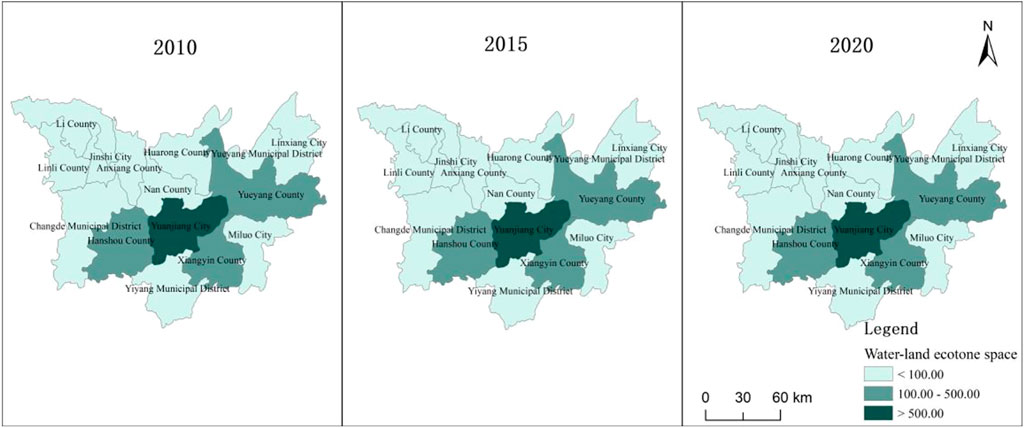
FIGURE 5. Regional structural differences of water-land mosaic zones in the Dongting Lake region from 2010 to 2020.
For the adjacent terrestrial zone (Figure 6), Yueyang County had the largest size, with a coastal terrestrial area of 379.11 km2 in 2010, 374.36 km2 in 2015, and 370.42 km2 in 2020. Lixian County came in second with a coastal terrestrial area of 308.59 km2 in 2010, 306.74 km2 in 2015, and 306.25 km2 in 2020. Nanxian County had the smallest coastal terrestrial area, less than 1 km2, followed by Anxiang County, with about 1.50 km2 coastal terrestrial area; they had no significant spatial changes in coastal terrestrial extent during the study period.

FIGURE 6. Regional structural differences of the adjacent terrestrial zone in the Dongting Lake region from 2010 to 2020.
As shown in Figure 7, the comprehensive functional value of the water ecological space in the Dongting Lake area improved from 0.3879 in 2010 to 0.4221 in 2020, increasing by 0.0341 and indicating an overall increase in functional service. Growth was most pronounced during 2010–2015, increasing by 0.0264.
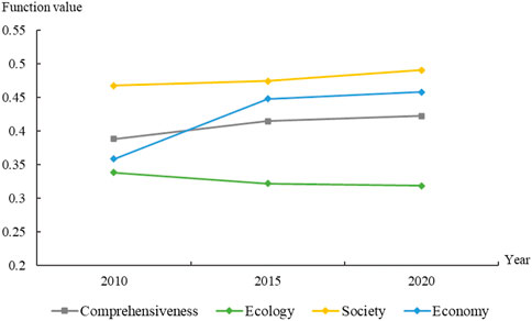
FIGURE 7. Changes in the spatial function of water ecology in the Dongting Lake area.
Additionally, there were more pronounced differences between units in terms of the integrated function of the water ecological space (Figure 8). Yuanjiang City had the highest integrated function value (0.7185 for 2010, 0.8210 for 2015, and 0.7748 for 2020), experiencing a process of rising and then falling, with a total increase of 0.0563. Huarong County and Xiangyin County had the next highest comprehensive functional values (above 0.6), improving over the given research period. Huarong County increased from 0.6092 in 2010 to 0.6527 in 2020, while Xiangyin County increased from 0.6030 in 2010 to 0.6350 in 2020. The comprehensive function of water ecological space in Jinshi City and Linli County was relatively low, which did not exceed 0.1 and slightly decreased for the study period. Linli County’s comprehensive function value decreased from 0.0693 in 2010 to 0.0665 in 2020, while Jinshi City’s decreased from 0.0544 to 0.0527. The comprehensive function of water ecological space declined at varying degrees in Linxiang City, Nanxian County, and Hanshou County. In ten units, including Anxiang County, Yueyang Municipal District, and Changde Municipal District, the overall functional value of the water ecological space increased to varying degrees; Anxiang County had the largest increase of 0.1450 among them.
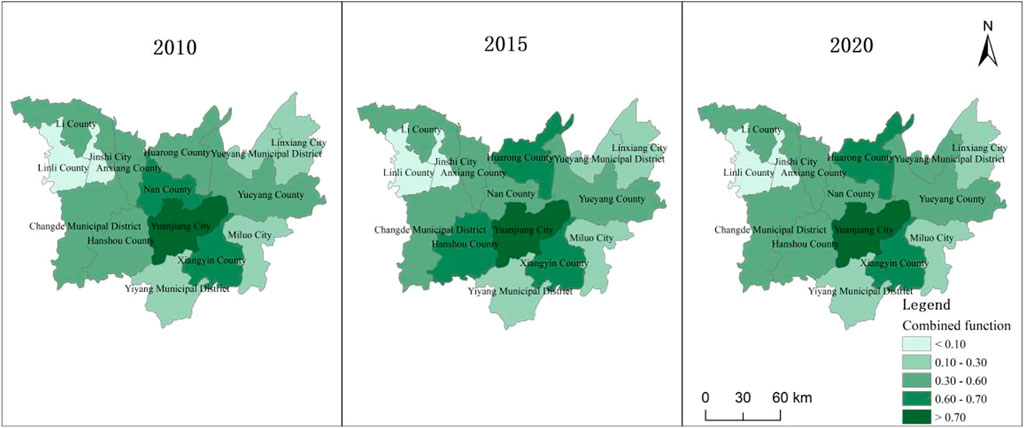
FIGURE 8. Differences in the integrated function value of water-ecological space in the Dongting Lake region from 2010 to 2020.
From Figure 7, the ecological function of the water ecological space in the study area exhibited a decreasing trend, decreasing from 0.3382 in 2010 to 0.3182 in 2020. This suggests that the ecological service function of the water ecological space in Dongting Lake had been disturbed to a certain extent, leading to a decrease in its natural regulation and support capacity. However, this decline has slowed, decreasing by 0.0167 in 2010–2015 to 0.0032 in 2015–2020, indicating that the construction of ecological civilization has significantly promoted the protection and restoration of water ecological spaces.
The spatial function values of the water ecological space differed significantly between units (Figure 9). In 2010, the unit with the highest ecological function value was Yueyang County (0.9586), followed by Yuanjiang City (0.7448) and Xiangyin County (0.5164), while Jin City had the lowest at 0.0970. The function values in the remaining units were mostly between 0.1 and 0.5, consistent with the distribution of water zones in the Dongting Lake area. The core waters and marshes of Dongting Lake are mainly located in Yueyang County, Yuanjiang City, Xiangyin County, Huarong County, and Yueyang City, so their water conservation value is high. Yueyang County, Xiangyin County, and Li County have wide forest regions, so their water and soil conservation value is relatively high. In these areas, the ecological function values of water ecological space are comparatively higher than the other units.
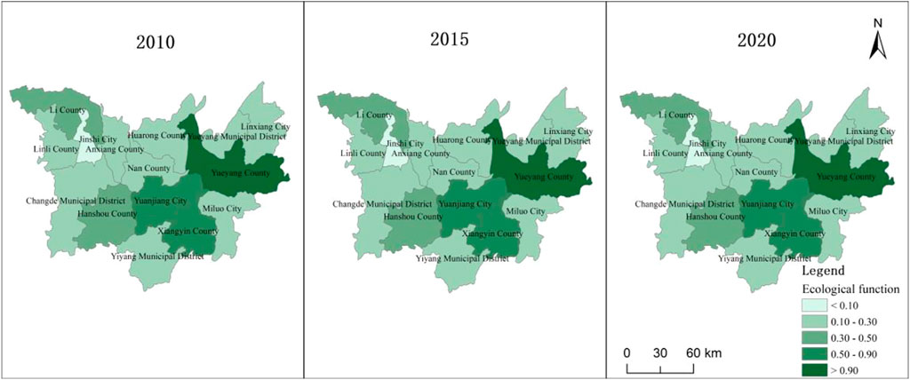
FIGURE 9. Differences in the ecological function value of water-ecological space in the Dongting Lake region from 2010 to 2020.
The spatial pattern of ecological function values did not change significantly. The largest ecological function value in 2015 and 2020 was still Yueyang County, at 0.9429 and 0.9401, respectively. The next two were still Yuanjiang City and Xiangyin County, with function values of 0.7254 and 0.5049 in 2015 and 0.7277 and 0.50 in 2020, respectively. In most units, the ecological function value of water ecological space decreased at varying degrees; Li County had the largest decrease at 0.0574, while Huarong County had the smallest decrease at 0.0054. Only Anxiang County and Nan County had an increase in the ecological function of water ecological space, but the improvement was relatively weak, both within 0.01.
As shown in Figure 7, the social function value increased from 0.47 in 2010 to 0.49 in 2020. This suggests that the reservoir pit building and shoreline flood management in the Dongting Lake area has improved, boosting the water resource support capacity and strengthening the region’s water security.
There were noticeable disparities in the social function values of water ecological space among the different units, with the spatial pattern changing dramatically during the study period (see Figure 10). In 2010, Linli county had the lowest social function value at only 0.0275, followed by Jin city at 0.0498. The remaining units had social function values between 0.1000 and 0.8000. Changde city had the highest social function value at 0.9075, followed by Hanshou county at 0.8997. In 2015, the two still had the highest social function values at 0.9443 and 0.9319, respectively, much higher than in 2010; Linli County and Jincheng City had the lowest at 0.0197 and 0.0455, both lower than in 2010. By 2020, Anxiang County had the highest social function value at 0.9157, followed by Nan County at 0.7826; Linli County (0.0331) and Jinshi City (0.0583) still had the lowest amounts but have greatly improved compared to 2010 and 2015. Ten units, including Anxiang County, Nanxian County, Lixian County, Yueyang Municipal District, and Yiyang Municipal District, had improved social function values; Anxiang County increased by 0.3022, the highest among the five. Changde City, Hanshou County, Linxiang City, Yuanjiang City, and Miluo City had declining values, with Hanshou County having the largest decline, decreasing by 0.2072.
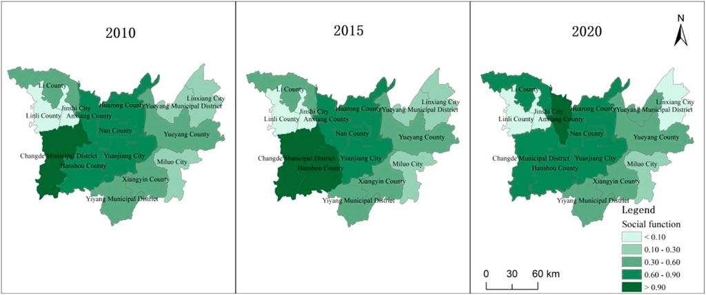
FIGURE 10. Differences in the social function value of water-ecological space in the Dongting Lake region from 2010 to 2020.
As observed in Figure 7, the economic function value exhibited an upward trend, rising from 0.3619 in 2010 to 0.4611 in 2020. This indicates that the Dongting Lake area’s economic production capacity and efficiency, which depend on water space, have increased and that the economic function of water ecological space has further developed.
For the regional units (see Figure 11), the values of the economic function of water ecological space also varied considerably, exhibiting temporal changes in the spatial pattern. In 2010, Nan County had the highest economic function value at 0.9283, followed by Huarong County at 0.8279 and Xiangyin County at 0.8034. Jin City had the lowest economic function value at 0.0163, followed by Linli County at 0.0427. In the remaining units, the economic function value of water ecological space typically ranged between 0.1000 and 0.8000. In 2015, Yuanjiang City had the largest economic function value of water ecological space at 0.9480 (increasing by 0.2758 from 2010), followed by Huarong County at 0.9431 (increasing by 0.1152 from 2010) and Xiangyin County at 0.8366 (increasing by 0.0333 from 2010). Jinshi City and Linli County came in last with 0.0118 and 0.0484, respectively; Jinshi City decreased by 0.0045 from 2010, while Linli County increased by 0.0057 from 2010. For 2020, Huarong County (0.9827) had the largest economic function value of aquatic ecological space, followed by Yuanjiang City (0.8658) and Xiangyin County (0.8593); the lowest economic function values of water ecological space were still Jinshi City (0.0103) and Linli County (0.0548). During the study period, only Nanxian County and Jinshi City had a decrease in economic function value of water ecological space, declining by 0.1902 and 0.0059. The economic functional value of the other units increased at varying degrees. Changde City’s growth rate was the highest, increasing by 0.4581, from 0.3078 in 2010 to 0.7659 in 2020.
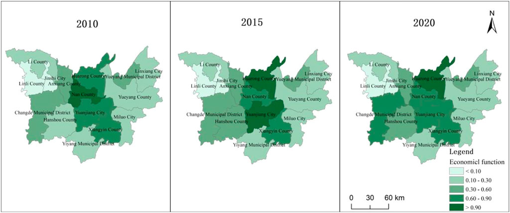
FIGURE 11. Differences in the economic function value of water-ecological space in the Dongting Lake region from 2010 to 2020.
The Dongting Lake area is a regional basin unit with Dongting Lake and several rivers at its core, and its development is centered on water ecological space. The region includes core water spaces, the areas where land and water crisscross, and lands adjacent to water. These form the foundation of the water ecological space and should be considered when managing and controlling the space. Water is a fundamental element that maintains the health and order of natural ecosystems and is vital for human survival. Therefore, the water ecological space has dual attributes, playing a decisive role in environmental sustainability and human development (see Figure 12).
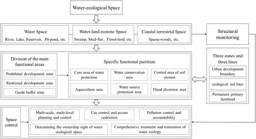
FIGURE 12. Spatial management and control framework for water-ecological space in the Dongting Lake region.
Water ecological space can be divided into different functional zones, such as core water conservation, water source conservation, soil erosion control, water source protection, flood regulation and storage, and aquatic product culture. The key to managing and protecting water ecological space is controlling these different functions. Therefore, this paper developed a water ecological space management and control framework from the perspective of “structure-function”, as shown in Figure 12.
The framework construction starts with identifying the structural elements, differentiating the functional spaces, and then delineating the zones (e.g., ecological protection red line, urban development boundary, and permanent basic farmland) to layout the functional regions of water ecological space, and systematic monitoring of this structural system of the water ecological space. We should strictly implement the access list system, improve the water resource confirmation and management system, strengthen source control, control pollution discharge, and strengthen ecological restoration to improve water quality and promote soil and water conservation.
The Dongting Lake area is crucial in the development of the Yangtze River Economic Belt and an important ecological and economic zone in Hunan Province. It comprises many counties and municipalities, so its management is multi-scale and multi-level. The upper limit of water resources, the bottom line of water environment quality, and the red line of water ecology protection should be used as constraints to scientifically and reasonably develop river and lake management and protection. The Dongting Lake will be integrated with other types of ecological protection red lines and protected areas to form a regional ecological barrier, combined with urban development boundaries and farmland borders, and incorporated into the national spatial planning system at provincial, municipal and county levels. The revisions to the Dongting Lake area plan should be accelerated to determine the strategic focus of spatial control.
The zoning control and hierarchical management should be strengthened from the watershed level, and positive and negative access lists should be developed for each control zone. The water ecological space control methods and systems should be improved, prohibiting water-related activities that do not conform to the positioning of each functional zoning of water ecological space. Existing water ecological space layouts and facilities should be integrated and optimized, promoting green construction that meets ecological requirements. To avoid disorderly development, ecological red lines (e.g., protecting drinking water, water conservation areas, protecting sensitive soil erosion areas) should be classified as prohibited development zones, where large-scale development and construction activities are strictly controlled and ecological core functions are resolutely maintained. Industries and facilities that do not meet the requirements to occupy water ecological spaces should be withdrawn unconditionally.
In restricted development zones, no urban construction activities should be carried out. Existing urban construction areas should be gradually withdrawn under conditions, establishing a scientific and reasonable exit mechanism and promoting technological upgrading and green transformation. Ecological industries should be encouraged in the restricted development zone, building green infrastructure such as ecological corridors and ecological isolation zones. In the buffer guidance area, low-polluting, low-energy consuming, and environment-friendly industrial activities should be supported, encouraging the development of modern waterfront leisure, ecological healthcare, green aquaculture, and other industries. The production activities of high pollution and high energy consumption should be carefully monitored and managed, controlling the scale of urban construction and building a compound layout integrated with water ecology.
The watershed is a systematic, holistic, and tightly connected area with strong interactions and constraints between upstream and downstream, trunk and tributaries, and left and right banks. Since it also involves different regions and sectors, spatial ownership and synergistic regional management should be clarified to promote high-quality development of the water ecological spaces. Water ecological space rights should be properly identified based on the waters, shorelines, staggered areas, and the scope of each delineated control area. The ownership and use rights of waters and shorelines (e.g., rivers, lake beaches, reservoir pits, ponds, wetland marshes) should be established to improve the utilization and management of water resources use. Market allocation and a market-oriented system of water ecological space property rights should be established, giving full play to the ecological, resource, social, and economic values of water spaces and guiding relevant interests to solve problems through market means. In addition, efforts should be made to build a regional collaborative governance mechanism, strengthen intra- and inter-regional synergy, and create a collaborative governance community with regional linkage, government organization, enterprise promotion and public participation. Differentiated ecological compensation standards should be developed for different regions, improving the docking mechanism of upstream, downstream, trunk, and tributaries and building a networked ecological compensation system.
The water resources and water quality management system should be improved, and the total water resources index should be decomposed to the relevant county-level administrative regions according to the actual situation of each unit. The total amount of restricted discharge of each municipal, county, and administrative unit should be decomposed step by step, and pollution restriction plans should be formulated in stages and regions. A suitable water quality assessment network should be established, strengthening the monitoring of water quantity, quality, and ecological value of important ecological function areas. A regional water ecological space quality monitoring and management index system should be established, and water ecological space control target assessment should be implemented based on the index system. Furthermore, the regional sewage reward and punishment system should be improved, cracking down on illegal and illicit sewage discharge and increasing administrative penalties.
Adhering to the concept of integrated management of “mountains, rivers, forests, fields, lakes, grass and sand,” the comprehensive management and restoration of water ecological space in the Dongting Lake area should be promoted. Polluted water bodies should be treated, and the water quality of the watershed should be improved. The treatment and restoration of mudflats and swamps should be increased to improve the ecological functions of wetlands and bring into play their great water purification, storage, and transfer values. The return of farming to the lake and forest should be scientifically and orderly promoted, developing a modern, green, and comprehensive agricultural industry system that reduces encroachment on water bodies and water-land intersection areas and avoids further shrinkage of Dongting Lake waters. At the same time, afforestation measures in the upstream areas should be strengthened to enhance water and soil ecosystem services and increase regional water security. In addition, a diversified water ecology governance and restoration system should be actively explored. The government can adopt purchasing services to attract social capital to participate in water ecology restoration and protection and adopt restoration and protection funds to support areas with weak payment capacity and improve water ecology governance and protection.
From the “function-structure” standpoint, this paper investigated the monitoring and control of water-ecological space in the Dongting Lake area. The structure and function of the water ecological space were assessed in 2010, 2015, and 2020 using land-use and related statistical data and ArcGIS analysis, and the framework system and key initiatives for spatial control were explored. The main conclusions obtained are as follows:
(1) The scale of water ecological space in the Dongting Lake area is more than 7,300 km2. The water area accounts for the largest proportion, accounting for about 50%, while the land-water ecotone accounts for the smallest proportion, accounting for about 24%. During the study period, the total area of aquatic ecological space decreased slightly; the decrease in water space was most pronounced, its proportion decreasing from 51.04% to 47.21%, while the area of land-water ecotone increased from 21.62% to 25.79%. In addition, there were considerable variations in the scale of water ecological space among the different administrative units. Yueyang County and Yuanjiang City had water ecological spaces larger than 1,000 km2, while Linli County and Jinshi City had below 200 km2.
(2) The comprehensive function of water ecological space in Dongting Lake increased from 0.3879 in 2010 to 0.4221 in 2010, indicating improved overall functional service. In particular, the social and economic function values increased considerably, while the ecological function value somewhat decreased. Yuanjiang City had the highest comprehensive function with a value of over 0.7000, while Jinshi City and Linli County had the lowest value of less than 0.1000. For ecological functions, the highest value was Yueyang County, while the lowest was Jinshi City. For social functions, the highest was Changde City and Anxiang County and the lowest was Linli County. For economic functions, the highest values were Nanxian Yuanjiang and Huarong while the lowest was Jinshi.
(3) The concept of harmony between man and nature should guide the management and control of the water ecological space in the Dongting Lake area. Starting with the structural components of the water ecological space, the various functional areas should be logically separated, the functional zoning of the water ecological space should be scientifically planned and laid out, and the delineation of ecological protection red lines, urban development boundaries, and permanent basic farmland should be combined. Based on this, multi-scale and multi-level planning oversight should be improved, access and use restrictions should be strictly regulated, the ownership of water ecological space should be properly defined, water quality monitoring and treatment should be integrated, pollution control and accountability should be improved, and comprehensive management and restoration of water ecology should be increased.
According to the research idea of “land use foundation-structural function system-pattern evolution monitoring-control system construction,” this paper explored the theory and method of water ecological space monitoring and control in the context of land space optimization. This study provides an in-depth analysis of water ecological space control, expanding the literature on water ecological space and offering a comprehensive perspective of micro-monitoring and single-function measurement. It is also a development in the study of national spatial planning for the modern era, advancing the reasonable delineation and adjustment of the “three zones and three lines” and crucial to the control of spatial use of national land and the preservation and high-quality development of water ecological spaces. In the age of ecological civilization, resolving conflicts between people and land and people and water is crucial in economic and social advancement (Zhou et al., 2020b). To mitigate the adverse effects of human activity on water ecosystems and promote water sustainability, it is crucial to explore and understand the various functions of water ecological spaces and the relationship between function and structure.
However, it should be noted that the classification system of water ecological space structure and function in this paper is still not sufficiently detailed due to limitations in data availability. For example, the subdivision structure and function did not include climate regulation, biodiversity maintenance, flood storage capacity, and other water ecological functions (e.g., waterfront leisure area, paddy field, and water buffer zone), limiting the current analysis depth. Subsequent studies should collect more data through multiple channels and means to establish a more comprehensive and detailed “structure-function” classification system. Additionally, due to space constraints, this paper did not address micro-water ecological quality monitoring and restoration issues, including water quality monitoring, aquatic organism quantity and diversity monitoring, water purification, and water resources supply management. This may limit future research on the quality supervision of water ecological space. In future research, the theory and technique for monitoring the pattern and quality of the landscape should integrate macro, meso, and micro scales to thoroughly assess the dynamic evolution of the water ecological space and carry out thorough scientific management and control.
The original contributions presented in the study are included in the article/Supplementary Material, further inquiries can be directed to the corresponding author.
ZZ: Conceptualization, methodology, software, formal analysis, writing—original draft and review and editing, project administration. HY: Methodology and formal analysis. HZ: Methodology, formal analysis, writing—review and editing. NL: Writing—review and editing, supervision, and funding acquisition. QS: Writing—review and editing, supervision. QJ: Writing—review and editing, supervision. QN: Writing—review and editing, supervision. All authors contributed to the article and approved the submitted version.
This research was funded by the “Research project of Hunan Geological Institute” (HNGSTP202206), “Scientific Research Foundation of Hunan Provincial Education Department of China” (No. 21A0506) and “National Science Foundation of Hunan Province of China” (No. 2022JJ50271).
The authors declare that the research was conducted in the absence of any commercial or financial relationships that could be construed as a potential conflict of interest.
All claims expressed in this article are solely those of the authors and do not necessarily represent those of their affiliated organizations, or those of the publisher, the editors and the reviewers. Any product that may be evaluated in this article, or claim that may be made by its manufacturer, is not guaranteed or endorsed by the publisher.
Aina, G., Bárbara, O., and Araceli, P. (2015). Environmental risk assessment of water quality in harbor areas: A new methodology applied to European ports. J. Environ. Manag. 155, 77–78. doi:10.1016/j.jenvman.2015.01.042
Alberti, M., Booth, D., Hill, K., Coburn, B., Avolio, C., Coe, S., et al. (2006). The impact of urban patterns on aquatic ecosystems: An empirical analysis in Puget lowland sub basins. Landsc. Urban Plan. 80 (4), 345–361. doi:10.1016/j.landurbplan.2006.08.001
Baltodano, A., Agramont, A., Reusen, I., and van Griensven, A. (2022). Land cover change and water quality: How remote sensing can help understand driver-impact relations in the lake titicaca basin. Water 14 (7), 1021. doi:10.3390/w14071021
Benra, F., De Frutos, A., Gaglio, M., Álvarez-Garretón, C., Felipe-Lucia, M., and Bonn, A. (2021). Mapping water ecosystem services: Evaluating InVEST model predictions in data scarce regions. Environ. Model. Softw. 138, e104982. doi:10.1016/j.envsoft.2021.104982
Bo, L. M., Wei, W., Yin, L., Zhao, L., and Xia, J. N. (2022). Changes in the spatial pattern of water ecology in the Yangtze River Economic Belt and its influencing factors from 2000 to 2020. China Environ. Sci. 2022. doi:10.19674/j.cnki.issn1000-6923.20220915.010
Cao, J., Wang, L., Chen, T. T., and Wei, Z. C. (2014). From ideal to reality: The construction of basic ecological space in cities: An example of the basic ecological space plan of feidong county, hefei city. Planner 30 (6), 51–57. doi:10.3969/j.issn.1006-0022.2014.06.008
Cecília, G. L., Paulo, S. P., Toby, A. G., Leitão, R. P., Hughes, R. M., Kaufmann, P. R., et al. (2016). Multi-scale assessment of human-induced changes to Amazonian instream habitats. Landsc. Ecol. 31 (8), 1725–1745. doi:10.1007/s10980-016-0358-x
Chen, D. L., Peng, B. F., and Xiong, J. X. (2013). The coupling characteristics of ecological and economic systems in the Dongting Lake area. Geoscience 33 (11), 1338–1346. doi:10.13249/j.cnki.sgs.2013.11.007
Chen, Q., Chen, Y. H., Wang, M. J., Jiang, W. G., Hou, P., and Li, Y. (2015a). Remote sensing comprehensive evaluation and change analysis of Dongting Lake ecosystem quality from 2001 to 2010. J. Ecol. 35 (13), 4347–4356. doi:10.5846/stxb201403250557
Chen, Y., Zhang, J. J., Du, G. M., Fu, M. C., and Liu, L. L. (2015b). Spatial and temporal evolution of ecosystem service values in the northern Sanjiang Plain. J. Ecol. 35 (18), 6157–6164. doi:10.5846/stxb201401020014
Chitresh, S., Binaya, K. M., and Pankaj, K. (2017). Integrated urban water management scenario modeling for sustainable water governance in Kathmandu Valley, Nepal. Sustain. Sci. 12 (6), 1037–1053. doi:10.1007/s11625-017-0471-z
Deng, C. X., Zhong, X. L., Xie, B. G., Wan, Y. L., and Song, X. W. (2019). Spatial and temporal variation in the service value of land ecosystems in the Dongting Lake area. Geogr. Res. 38 (04), 844–855. doi:10.11821/dlyj020170999
Deng, W., Yan, D. H., He, Y., and Zhang, G. X. (2004). Research on water ecological space in watersheds. Adv. Water Sci. 3, 341–345. doi:10.14042/j.cnki.32.1309.2004.03.014
Du, Z., Zhang, G., and Shen, L. F. (2013). Research on ecological space control in Chengdu. Urban Plan. 37 (8), 84–88.
Gerald, E., and Galloway, M. (1997). river basin management in the 21st century: Blending development with economic, ecologic, and cultural sustainability. Water Int. 22 (2), 82–89. doi:10.1080/02508069708686675
Ghosh, A., and Maiti, R. (2021). Development of new Ecological Susceptibility Index (ESI) for monitoring ecological risk of river corridor using FAHP and AHP and its application on the Mayurakshi river of Eastern India. Ecol. Inf. 63, 101318. doi:10.1016/j.ecoinf.2021.101318
Huang, X. X., Jiang, Y., Xiong, X., He, K. J., and Zhang, Y. (2012). Research on water ecological function zoning. Water Resour. Conserv. 3, 22–27. doi:10.3969/j.issn.1004-6933.2012.03.004
Jiang, C., Liu, H. Y., Chen, Z., Rao, C., and Li, Z. D. (2018). GIS-based land use change and water quality response in the Hongfeng Lake watershed. J. Agric. Environ. Sci. 37 (6), 1232–1239. doi:10.11654/jaes.2017-1598
Kang, L. T., Hu, X. J., Luo, Z. W., Wei, B. J., and Zhou, D. M. (2022). Spatial identification of county water ecology and its distribution characteristics. J. Soil Water Conservation 36 (01), 170–181. doi:10.13870/j.cnki.stbcxb.2022.01.023
Li, J. C., Wang, W. L., and Hu, G. Y. (2011). Impacts of land use and cover changes on ecosystem service value in Zoige Plateau. Acta Ecol. Sin. 31 (12), 3451–3459.
Li, Y. M., Zeng, W. X., and Zhou, Q. X. (2009). Research progress of water ecological function zoning. J. Appl. Ecol. 20 (12), 3101–3108. doi:10.13287/j.1001-9332.2009.042
Liu, C., Xu, Y. Q., Liu, Y. X., Sun, P. L., Huang, A., and Zhou, J. (2018a). A system theory-based multifunctional land use classification and evaluation index system. J. Peking Univ. Nat. Sci. Ed. 54 (1), 181–188. doi:10.13209/j.0479-8023.2017.132
Liu, M., and Wang, K. L. (2008). Landscape pattern change and its driving forces in middle and upper reaches of Dongting Lake watershed. J. Appl. Ecol. 19 (6), 1317–1324. doi:10.13287/j.1001-9332.2008.0231
Liu, P., Duan, J. N., Wang, W., and Zeng, M. (2010). Study on functional classification and evaluation system of land use system. J. Hunan Agric. Univ. Nat. Sci. Ed. 36 (1), 113–118.
Liu, W., Yang, Q., Zhang, M. R., Zhao, W., and Zhai, Y. (2018b). Research on building a watershed-based spatial control system for water ecology. China Water Resour. 5, 27–31.
Liu, Z., Zhang, N., Peng, D. H., Zhang, Y. Z., Zhang, D., and Qin, X. C. (2022). DNAJA4 promotes the replication of the Chinese giant salamander iridovirus. Environ. Monit. China 38 (01), 58–71. doi:10.3390/genes14010058
Ning, Q. M., Ouyang, H. Y., Tang, F. H., and Zeng, Z. W. (2020). Spatial and temporal evolution of landscape patterns in the Dongting Lake area under the influence of land use change. Econ. Geogr. 40 (09), 196–203. doi:10.15957/j.cnki.jjdl.2020.09.021
Ouyang, X., Xu, J., Li, J. Y., Wei, X., and Li, Y. H. (2022). Land space optimization of urban-agriculture-ecological functions in the Changsha-Zhuzhou-Xiangtan Urban Agglomeration, China. Land Use Policy 117, 1061112. doi:10.1016/j.landusepol.2022.106112
Qiu, B., Liu, W., Zhang, J. Y., Zhang, M. R., and Zhao, W. (2017). Exploration of water ecological spatial control system construction. China Water Resour. 16, 16–20.
Ren, J. L., Li, H., Wu, X. M., and Li, X. S. (2016). Evaluation of water ecological civilization in provincial capital cities of Yangtze River Economic Belt based on principal component analysis. Yangtze River Basin Resour. Environ. 25 (10), 1537–1544. doi:10.11870/cjlyzyyhj201610008
Su, C. W., Deng, Z. B., Li, L. P., Wen, J. X., and Cao, Y. F. (2021). Spatial pattern evolution and convergence of water eco-civilization development index in China. J. Nat. Resour. 36 (05), 1282–1301. doi:10.31497/zrzyxb.20210515
Tang, Y., WangWang, C. G. W. Q., Huang, H. J., and Yuan, Y. (2020). Multifunctional classification of aquatic habitats for remote sensing data. Adv. Geoscience 39 (3), 454–460. doi:10.18306/dlkxjz.2020.03.010
Wang, Q., and Tang, F. H. (2015). Spatial and temporal differentiation of the coupled and coordinated development of ecological-economic-social systems in the Dongting Lake area. Econ. Geogr. 35 (12), 161–167. doi:10.15957/j.cnki.jjdl.2015.12.023
Wei, G. E., Bi, M., Liu, X., Zhang, Z. K., and He, B. J. (2023). Investigating the impact of multi-dimensional urbanization and FDI on carbon emissions in the belt and road initiative region: Direct and spillover effects. J. Clean. Prod. 384, 135608. doi:10.1016/j.jclepro.2022.135608
Wu, D., Zhang, L., Yu, L., Ding, N., and Tang, Z. (2021). Research on ecological management of water affairs under the high quality development of land space: The case of guangming district, shenzhen. J. Urban Plan. 4, 66–73. doi:10.16361/j.upf.202104010
Xie, G. D., Lu, C. X., Leng, Y. F., Zheng, D., and Li, S. C. (2003). Valuation of ecological assets on the Qinghai-Tibet Plateau[J]. J. Nat. Resour. 18 (2), 189–196.
Yang, F., Li, Z., Luo, W. L., Wu, G., Lippuner, K., and Hunziker, E. B. (2021). Anticytokine Activity Enhances Osteogenesis of Bioactive Implants. Econ. Geogr. 41 (08), 177–186. doi:10.1089/ten.TEA.2020.0067
Yang, Q., Wang, X. H., Zhang, J. Y., Zhao, W., Jia, R., Zhu, D., et al. (2017a). GoTLR7 but not GoTLR21 mediated antiviral immune responses against low pathogenic H9N2 AIV and Newcastle disease virus infection. China Water Resour. 3, 6–15. doi:10.1016/j.imlet.2016.11.001
Yang, Q., Zhang, M. R., Zhao, W., Zhang, J. Y., and Wang, X. H. (2017b). Water ecological spatial function and control classification. China Water Resour. 12, 3–5. doi:10.13201/j.issn.1001-1781.2017.01.002
Yang, Q., Zhao, W., Zhang, J. Y., and Wang, X. H. (2017c). Construction of water ecological space control index system. China Water Resour. 9, 1–5.
Yin, K., Liu, H. J., Wang, G., and Jin, X. W. (2021). Overview of habitat monitoring methods under spatial control of watershed water ecology. Environ. Sci. 42 (03), 1581–1590. doi:10.13227/j.hjkx.202007287
Zhou, L., Dang, X. W., Mu, H. W., Wang, B., and Wang, S. H. (2020b). Cities are going uphill: Slope gradient analysis of urban expansion and its driving factors in China. Sci. Total Environ. 775, 145836–145910. doi:10.1016/j.scitotenv.2021.145836
Zhou, L., Hu, F. N., Wang, B., Wei, C. Z., Sun, D. Q., and Wang, S. H. (2022b). Relationship between urban landscape structure and land surface temperature: spatial hierarchy and interaction effects. Sustain. Cities Soc. 80, 103795–103812. doi:10.1016/j.scs.2022.103795
Zhou, L., Yuan, B., Hu, F. N., Wei, C. Z., Dang, X. W., and Sun, D. Q. (2022a). Understanding the effects of 2D/3D urban morphology on land surface temperature based on local climate zones. Build. Environ. 208, 108578–108610. doi:10.1016/j.buildenv.2021.108578
Zhou, L., Zhou, C. H., Che, L., and Wang, B. (2020a). Spatio-temporal evolution and influencing factors of urban green development efficiency in China. J. Geogr. Sci. 30 (5), 724–742. doi:10.1007/s11442-020-1752-5
Zhu, D. S., Zhang, J. Y., Wang, X. H., and Yang, Q. (2017). Ideas for promoting spatial control of water ecology in China. China Water Resour. 16, 1–5.
Keywords: water-ecological space, structure-function, monitoring and control, Dongting Lake, territorial spatial planning
Citation: Zeng Z, Yang H, Zhou H, Lai N, Song Q, Ji Q and Ning Q (2023) Monitoring and control of water-ecological space in the Dongting Lake region. Front. Environ. Sci. 11:1200513. doi: 10.3389/fenvs.2023.1200513
Received: 05 April 2023; Accepted: 02 May 2023;
Published: 09 June 2023.
Edited by:
Xiao Ouyang, Hunan University of Finance and Economics, ChinaCopyright © 2023 Zeng, Yang, Zhou, Lai, Song, Ji and Ning. This is an open-access article distributed under the terms of the Creative Commons Attribution License (CC BY). The use, distribution or reproduction in other forums is permitted, provided the original author(s) and the copyright owner(s) are credited and that the original publication in this journal is cited, in accordance with accepted academic practice. No use, distribution or reproduction is permitted which does not comply with these terms.
*Correspondence: Hua Yang, eWgxOTExMjE2MjZAMTYzLmNvbQ==
Disclaimer: All claims expressed in this article are solely those of the authors and do not necessarily represent those of their affiliated organizations, or those of the publisher, the editors and the reviewers. Any product that may be evaluated in this article or claim that may be made by its manufacturer is not guaranteed or endorsed by the publisher.
Research integrity at Frontiers
Learn more about the work of our research integrity team to safeguard the quality of each article we publish.