 Hao Shi
 Dapeng Yue*
- School of Geography and Tourism, Shaanxi Normal University, Xi’an, China
The research purpose of this paper is to reveal the relationship between flood deposits, rainfall and flooding in the Loess Plateau over the last 50 years. The research in this paper is of great significance as it reveals the torrential flood events and soil erosion in the central region of the Loess Plateau. Through grading analysis and 137Cs content determination of a closed lake sedimentary profile formed by landslide-blocked rivers in middle part of Loess Plateau, Zizhou County, Shaanxi Province, the age of the sedimentary formation in the section, as well as the rainstorm events and changes of soil erosion since 1954 are studied. The results show that the sediment particle size composition in the study section is fine, mainly comprising of coarse silt, while the content of sand particles (>100 μm) is very low. The changes in137Cs content show that the sedimentary layer at a depth of 280–210 cm in the research profile was formed between 1954 and 1964, while the deep sedimentary layer at 210–70 cm was formed between 1965 and 1986 and the sedimentary layer above 70 cm depth was formed between 1987 and 2011. In total, 20 coarse particle layers (particle size >50 μm) were deposited in the lake between 1954 and 2011. The sedimentation timing of the 20 coarse particle layers was basically consistent with the timing of rainstorm events (daily rainfall ≥60 mm) in the study area, indicating that the coarse particle sediments in the lake represent rainstorm events. Soil erosion was stronger between 1954 and 1985 and was weaker after 1986.
1 Introduction
The hilly and gully areas of the Loess Plateau are the areas with the most severe soil erosion in China and even the world (Wang et al., 2022). The research of soil and water conservation in this area has important scientific research significance, which not only promotes the development of ecological environment and improves living conditions, but also provides a basis for soil erosion research in others area (Lin et al., 2022). The granularity composition of flood sediment has an important indicating role in transportation force, flood frequency and rainstorm events. (Chen et al., 1991; Peng et al., 2005; Shen et al., 2006; Sitoe et al., 2015). The granularity and minerals of lacustrine deposits also have an important indicative role for determining flood events (Zhang et al., 2015). Studies of Quaternary river floods have produced many important results. The occurrence of modern floods is often caused by the increase of rainfall and uneven distribution of rainfall (Huang et al., 2004; Zhao et al., 2007). Previous research on the Weihe River flood sediments in the Xi ‘an region showed that flooding occurred 16 times in the last 120 years and that the floods were mainly caused by intensified monsoon activity in the summer (Zhao et al., 2007). The research regarding flooding of the Qishui River in western Guanzhong during the Holocene shows that flooding was 20-times more frequent approximately 4,650–3,000 years ago (Zha et al., 2007). The study of flood sediments in the Jianghan Plain of Hubei showed that a total of 168 floods took place in the Holocene epoch and that the floods were mainly related to climate (Zhu et al., 1997). The research regarding flood sediments of the Yellow River in China showed that a total of 106 flood events occurred approximately 20–18 ka years ago in the upstream of the Yellow River (Li et al., 2002).
Internationally, flood research has mainly concentrated on the sedimentary history of the past 500 years, with a focus on flood events, changes in flood flow, and flood causes. (Saint, 2004; Knox, 1994; Macklin et al., 2006; Tessa et al., 2015; Piotr et al., 2016). Studies show that past floods were sensitive to climate change and that this was the main factor causing the flood (Macklin et al., 2006; Thorndycraft and Benito, 2006; Benito et al., 2015; Gebica et al., 2016). The occurrence of floods is not only related to climate but also associated with solar activity (Wirth et al., 2013). Research shows that river sediments can be used to study floods and that lake sediments can indicate the occurrence and changes of floods (Schillereff et al., 2014; Jenny et al., 2014); furthermore, karst chemical deposition can also reflect the flood frequency and magnitude change (Saúl et al., 2015).
For the long-lasting flood deposits, 14C and OSL (Optical Stimulated Luminescence), among others techniques, are often used to determine the age of sediments (Long et al., 2009; Zhu et al., 2011). For flood sediments from the last 100 years 137Cs is used to determine its age (Zhang et al., 2007). Much research has been conducted on modern soil erosion but additional research about soil erosion in the geological period and the last 500 years is needed. Torrential events are typically identified by analyzing monthly and daily precipitation data. However, in certain regions of the Loess Plateau in northern Shaanxi, China, there is a lack of statistical data regarding daily and monthly precipitation. Thus, it becomes necessary to identify torrential events through the study of sediment cores. Based on the flood sediment particle size composition analysis and 137Cs content determination, this study considers the flood sedimentary cycle, rainstorm events and soil erosion changes in the small watershed of Huangtuwa in the Loess Plateau of Northern Shaanxi, China.
2 General situation of research area
The studied lake is a seasonal lake that was formed by past landslides blocking river channels. Flood sediments are formed in the rainy season every year. The lake is located near Huangtuwa Village, Peijiawan Town, Zizhou County, Shaanxi Province, which is about 50 km from the Zizhou County to the south and about 30 km from Suide County to the southwest (geographical coordinates 109°59′E, 37°19′N) (Figure 1). According to records in the Qingjian County Annals (Yang, 2001), this lake is more than 440 years old and was formed by a landslide, which blocked several rivers, in A.D. 1569. The lake is located in the loess hilly-gully region and its surrounding is the Quaternary loess stratum, which is generally about 150 m thick at most. This lake has a closed characteristic, constituting a small watershed; the main channel of the basin is 4.21 km long and runs in a north-south direction, forming eight tributaries on both sides of the main channel, with an area of approximately 0.58 km2, and the surrounding loess ridges and loess hills are about 150 m higher than the lake depression. The gully slope in the basin is generally about 10°–25° and when the loose loess is affected by heavy rains serious soil erosion often occurs.
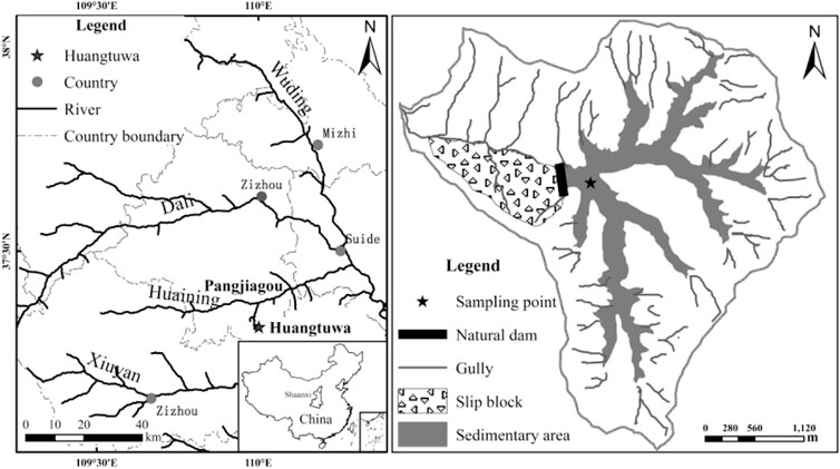
FIGURE 1. Location of research profile.
The research area is characterised by a warm temperate semi-arid climate. Rainfall is low with an average annual precipitation of 486 mm. The distribution of annual precipitation is uneven, whereby 65% of annual precipitation falls in July–September. The average annual temperature is 9°C–10°C, with hot summers and cold winters.
3 Research method and sampling
Through repeated investigation of lacustrine sediments in Huangtuwa, Zizhou County, we excavated a profile to a depth of 4.4 m in a flat location of lacustrine deposits and took samples for grading analysis at an interval of 2 cm. In order to avoid the influence of artificial cultivation, samples were not taken from the 30 cm of topsoil. Therefore the actual sampling profile depth was 410 cm and a total of 205 samples were taken for grading analysis. The sampling interval of 137Cs samples was 10 cm and a total of 41 samples were taken.
Grading analysis was performed using 0.8 g of sample. Organic matter was removed by adding 15 ml 10% H2O2, then 10 ml 10% HCl was added to remove secondary carbonates and then a suitable amount of (Na2PO3)6 was added to disperse samples. After processing the samples, a Mastersizer 2000 laser particle analyser, produced by the British company Malvern, was used to determine particle size. Each sample was analysed three times and the average taken. Measurement error was less than 2%. Samples were air-dried and then ground into powder and then analysed using a DSPEC jr2.0 Y-Energy Disperse Spectroscopy, produced by ORTEC, for 137Cs content determination. The determination time was 40,000–80000s. The granularity composition division standard is that: particles< 0.002 mm are colloidal particles, particles sized 0.002–0.005 mm are clay, particles sized 0.005–0.01 mm are fine silt, particle sized 0.01–0.05 mm are coarse silt, particles sized 0.05–0.10 mm are very fine sand, particles sized 0.10–0.25 mm are fine sand, particles sized 0.25–0.50 mm are medium sand and particles sized 0.50–2 mm are coarse sand (Wang and Bao, 1964). The annual precipitation data used is observation data recorded by the Suide weather station from 1954 to 2011.
4 Results and analysis
4.1 Profile granularity composition change and sedimentary cycle division
It can be seen from the grading analysis of the 205 samples collected (Table 1) that the flood deposition near Huangtuwa Village is mainly coarse silt, with a content ranging from 30.61% to 68.61% and an average content of 49.61%. This dominant fraction is followed by fine silt, clay, very fine sand and colloidal particles, the average content of which is 16.12%, 12.68%, 12.23%, 7.92%, respectively. The component of granularity> 0.10 mm is rare and its content at some depths is zero.
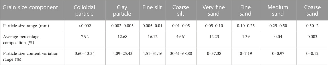
TABLE 1. Flood deposition grain-size component and content near Huangtuwa Village.
The change of particle size composition in the research profile is obvious and shows the law of alternating change of coarse or fine variations. The flood deposits in the whole profile can be divided into 57 layers according to the particle size content (Table 2). In the 57 layers, the layers with odd numbers (1, 3, 5, 7) are composed of fine particle layers of small size; the content of very fine sand and the contribution of particles greater than 100 μm is low, while the content of fine silt and the contribution of particles smaller than 5 μm is high. The layers with even numbers (2, 4, 6, 8) are coarse grain layers, which are characterized by large particles; the content of very fine sand and particles greater than 100 μm is high, while the content of fine silt and particles smaller than 5 μm is lower.
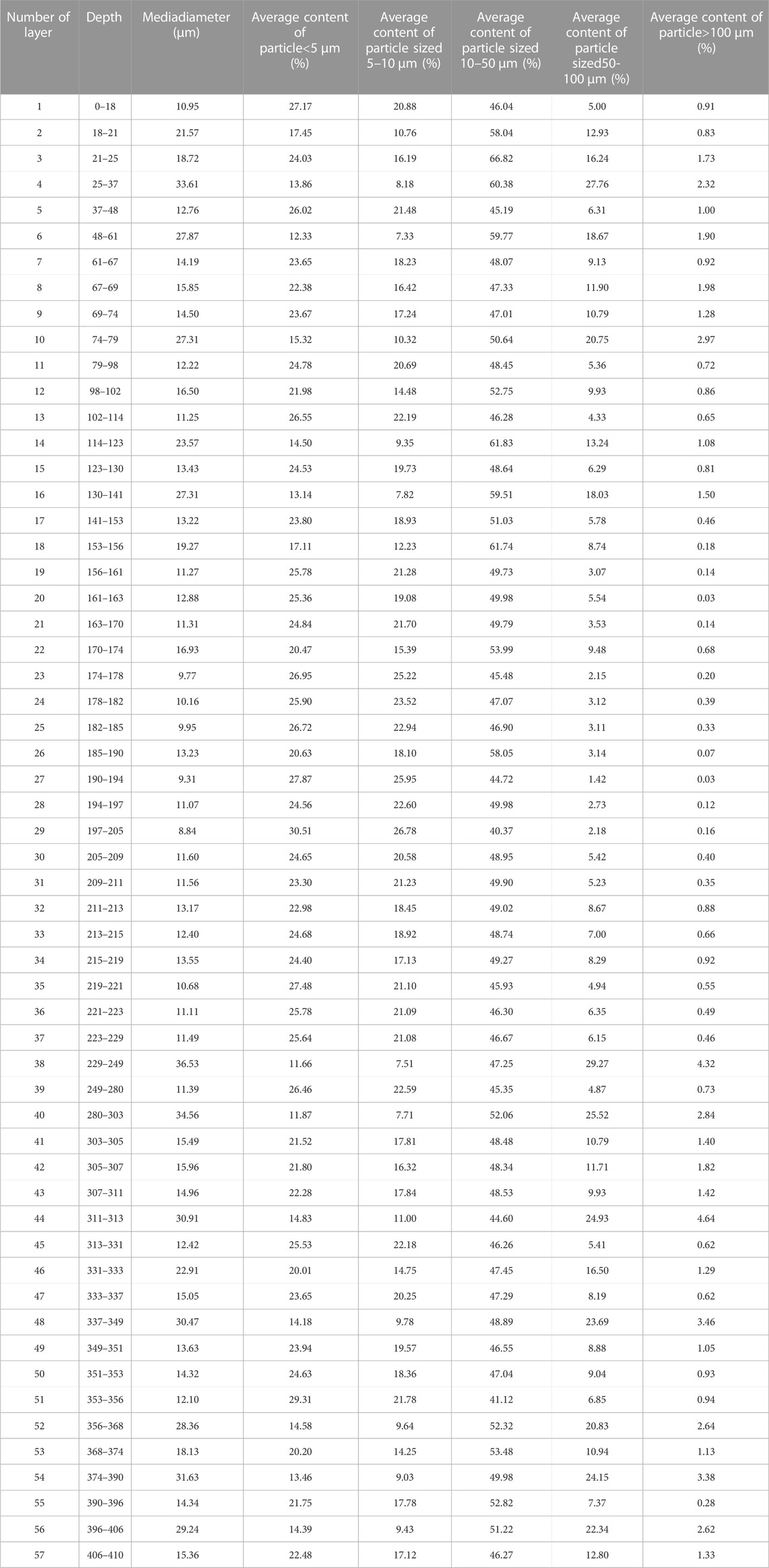
TABLE 2. Profile particle size stratification and the average content of particle size in each layer.
According to the principle of the coarse particle layers representing massive floods and fine particle layers representing small-scale floods (Wei et al., 2006) and on the basis of the different medians of flood-related sedimentary sections in Huangtuwa, the whole profile can be divided into 28 depositional cycles. Each depositional cycle includes a coarse particle layer and a fine particle layer (Figure 2). Among them, the curve of median size of cycles A1–A12 and a1–a11 is single peak and single valley type, showing that the sediment layer is formed by a complete flood handling and stacking. The peak value of the median size of the cycle curve A1–A12 is larger, the content of coarse particles is high and the sedimentary thickness is large, thus showing that the power of the water is great. The peak value of the median size of the cycle curve a1–a11 is smaller and the sedimentary thickness is small, showing that the power of the water is small. The pattern of the median size of the cycle curve B1-B5 is double-peak and double-valley type, which may be caused by the shorter interval of floods formed by two periods of heavy rainfall; specifically, the second heavy rainfall occurs before the sediments carried by the previous flood are completely deposited, thus producing double peaks and double valleys, or multiple peaks and multiple valleys.
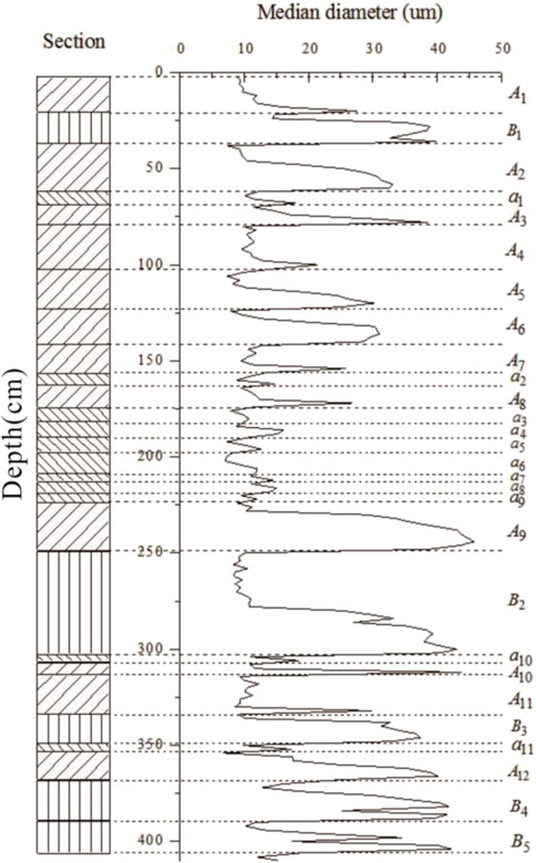
FIGURE 2. Division of sedimentary cycles in the profile.
4.2 Flood sediment age indicated by 137Cs content
137Cs in the surface soil mainly comes from deposition of nuclear dust generated in 1950s–1970s.The half-life period of 137Cs is 30.1 years (Zhang et al., 1988). The sedimentation pattern is mainly being produced as a result of rainfall bringing the dust to the Earth’s surface and then the dust being strongly absorbed by soil fine particles, which will basically not be absorbed by plants, or affected by eluviation. The redistribution of 137Cs on the Earth’s surface occurs as a result of soil movement (Zhang et al., 2006; Zhang et al., 2007; Zhang et al., 2011). After the deposition of 137Cs, the soil fine particle soil fraction, which adsorbs the 137Cs, will be mobile for only a short time and quickly be buried by subsequent sediments. Vertical movement of the soil particles are also considered to be very small. As a result, the deepest layer of 137Cs sedimentation can be considered indicative of the release of atmospheric 137Cs generated by nuclear testing in 1954. The sediment in this study profile comes from the eroded soil in the small watershed of the lake, and the 137Cs that settles with rainwater and the movement and deposition of eroded particles occur in a short period of time. Afterwards, they are buried by the later eroded soil materials, and the vertical movement of soil particles is very limited. Therefore, the deepest layer in this profile where 137Cs is present can indicate their association with nuclear tests in 1954.
The 137Cs first appears in the profile at a depth of 280 cm and reaches a peak at 210 cm (Figure 3). Previous research showed that the first sedimentation of 137Cs in the near–surface layer in China occurred in 1954 and reached a peak in 1963 or 1964 (Wang et al., 1991). In the Northern Hemisphere, the main sedimentation period of 137Cs was 1954–1970 (Zapata, 2002). Thus, the layers in this study profile above 280 cm depth were deposited after 1954. As the sedimentation component of 137Cs in the Northern Hemisphere was higher in 1959 (Owens et al., 1997), the peak of 137Cs at 270 cm deep was deposited in 1959. The content of 137Cs in this profile reaches a maximum value at a depth of 210 cm, indicating that the formation time of this layer was 1964. The leaked 137Cs from the Chernobyl accident within the territory of Ukraine, of the former Soviet Union, in April 1986 had a certain effect on China (Qi et al., 2006) and formed a peak in sediment profiles (Zhang, 2005). Therefore, the high content peak of 137Cs at 70 cm depth was formed in 1986. Thus, the sedimentary layers above 280 cm depth in the profile were formed by flood sediments between 1954 and 2011, the sedimentary layers at 280–210 cm depth were formed between 1954 and 1964, the sedimentary layers at 210–70 cm depth were formed between 1965 and 1986 and the sedimentary layers above 70 cm depth were formed between 1987 and 2011.
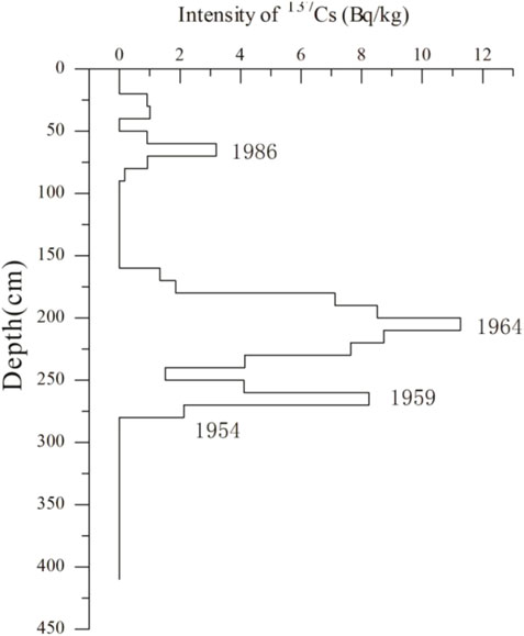
FIGURE 3. 137Cs content and sedimentation time of research profile.
5 Discussion
5.1 Rainstorm events indicated by granularity composition
The main factors influencing the particle size composition of the research profile include the particle size of material in surrounding ditches and gullies and the hydrodynamic conditions. Due to the relatively stable sediment source of the seasonal lake in Huangtuwa, the content of coarse particles in the sediments can indicate the strength of the water and rainstorm events.
An event is considered a rainstorm when the total rainfall in 24 h is greater than or equal to 50 mm (Zhang, 1983). It can be seen that a total of 35 rainstorm events occurred in this region between 1954 and 2011 (Figure 4; Rainstorm events (daily rainfall ≥50 mm) in Huangtuwa area since 1954. The broken line represents a daily rainfall of ≥60 mm). The rainstorm (daily rainfall ≥50 mm) has a close relationship with soil erosion in the small watershed of Huangtuwa and the 35 rainstorm events that occurred between 1954 and 2011 would certainly be recorded in the lake sediments of Huangtuwa Village.
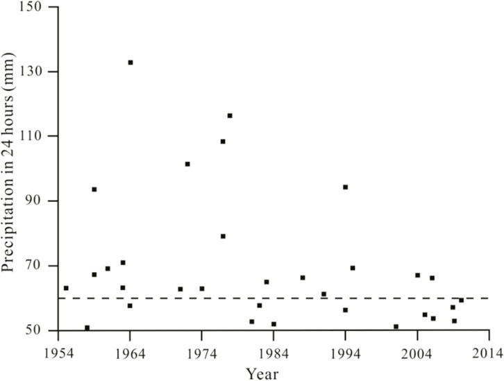
FIGURE 4. Rainstorm events (daily rainfall ≥50 mm) in Huangtuwa area since 1954. The broken line represents a daily rainfall of ≥60 mm.
As precipitation less than 50 mm may also cause sedimentation in depressions, the actual depositional cycle is far more than the number (35) of classified rainstorms (daily rainfall ≥50 mm). Therefore, each depositional cycle does not represent a rainfall event with daily precipitation≥50 mm. It can be seen from the particle size composition analysis of the sediments sized 50–100 μm and >100 μm that in the sedimentary profile, above 280 cm depth, there are a total of 20 obvious layers with a high content of coarse particles (Figure 5). Based on the statistics of the number of rainstorm events (daily rainfall ≥50 mm) and comparison with the 20 coarse particle (50–100 μm and >100 μm) layers, the two have no significant correlation.
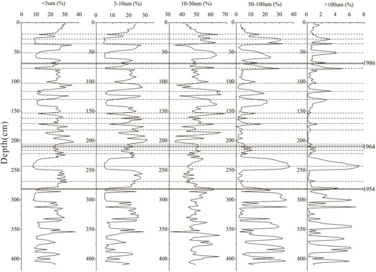
FIGURE 5. Flood sediment particle size composition changes near Huangtuwa Village since 1954.
The standard classification of a rainstorm (daily rainfall ≥50 mm) will not necessarily conform to the erosion and sedimentation law of coarse particles in the watershed of Huangtuwa. We assume that only a rainstorm where daily rainfall ≥60 mm will result in the erosion, transportation and deposition of coarse particles. It can be seen from the comparison between the timing of rainfall events (daily rainfall ≥60 mm) and the 20 layers with high coarse particle content that the days where daily rainfall is ≥60 mm in Huangtuwa area corresponds well with layers of coarse particle sediments. There have been a total of 20 rainstorms (daily rainfall ≥60 mm) in the watershed of Huangtuwa since 1954 (Table 3) and there are a total of 20 instances when the content of coarse particles in the lake sediment profile have significantly increased since 1954. Thus, it can be concluded from this that the coarse particle sediment layers in the research profile represent the rainstorm events (daily rainfall ≥60 mm).
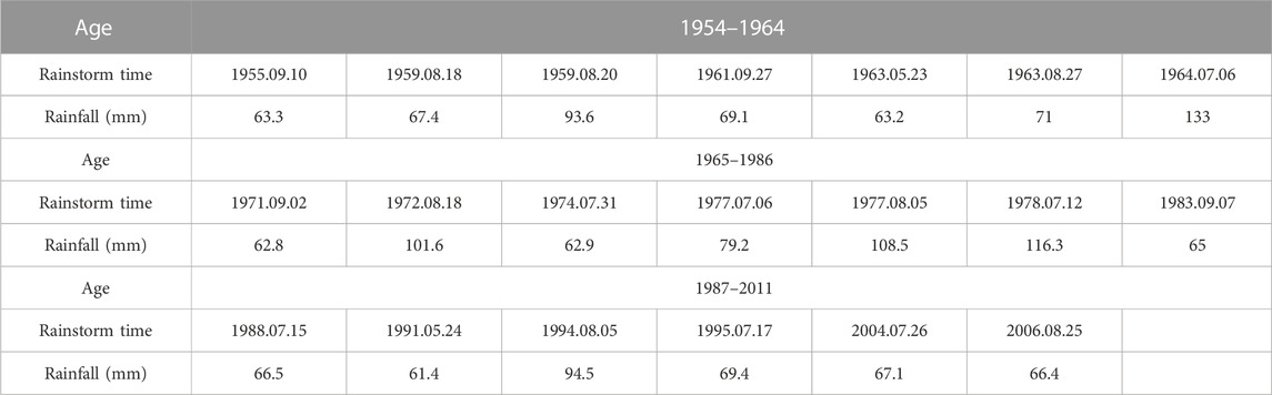
TABLE 3. Rainfall data (daily rainfall ≥60 mm) since 1954 in the research region.
5.2 Abnormal value in coarse particle deposition and its reason
According to the age determined by the137Cs content, the layers with a significant increase in coarse particles in the lacustrine deposit near Huangtuwa Village can be used to indicate past rainstorm events (where daily rainfall ≥60 mm). The occurrence of these events rainfall (daily rainfall ≥60 mm) basically corresponds with the layer in the sedimentary profile where the content of coarse particle significantly increases.
According to the age determined by the137Cs content, we determined the layers formed in 1954, 1964 and 1986 in the research profile at depths of 280 cm, 210 cm and 70 cm, respectively. From 1954 to 1964, there were a total of seven rainstorm events (daily rainfall ≥60 mm); however, the sedimentary layers at 210–280 cm depth corresponded to six coarse particle layers. Between 1965 and 1986 there were a total of seven rainstorm events (daily rainfall ≥60 mm) and the settled layers formed in this phase corresponded to nine coarse particle layers. From 1987 to 2011 there were a total of six rainstorm events (daily rainfall ≥60 mm) and the flood sediment layers formed in this phase corresponded to five coarse particle layers.
Coarse particle deposition corresponds well to the rainstorm data (daily rainfall ≥60 mm) in this region but there are also the following abnormal values.
(1) In the period 1954 to 1964 there were seven rainstorm events (daily rainfall ≥60 mm) but there were only six coarse particle layers in this period. Analysis of the timing of rainstorms (daily rainfall ≥60 mm) in the study area from the meteorological data revealed that a rainfall event of 67.4 mm occurred on 18 August 1959 but a day later, namely, August 20th, another heavy rain occurred with a total rainfall of 93.6 mm. In general, a storm corresponds to a depositional cycle so two sedimentary cycles were formed in 1959; however, because the interval between the two heavy rains was very small, the material carried by the first rainstorm flood was not completely deposited before additional material carried by the subsequent rainstorm flood occurred, thereby causing the sediments of two heavy rains to be mixed together. Consequently the two heavy rains only correspond to a single coarse particle layer.
(2) There were a total of seven rainstorms (daily rainfall ≥60 mm) from 1965 to 1986 but there were nine obvious coarse sedimentary layers during the corresponding period. Through the analysis of Figure 2 it is found that the coarse particle content is not stable, namely, the coarse particle content in the adjacent two layers varies widely. Through further analysis of rainfall data it was found that the heavy rain on 6 July 1964 was the largest rainstorm event of the last 60 years but the coarse particle content is not the highest in the profile. Studies show that soil erosion in Loess Plateau hilly region is not only related to rainfall but also to the initial strength and continuous process of heavy rain (Zhang, 1983). As a result, it is not the largest storm that causes the most deposition of coarse particles. Rainstorms often occur in the Loess Plateau region over many consecutive days and while the total rainfall may be <60 mm per day, the continuous heavy rains cause soil water saturation. Consequently, if the rainfall the next day is nearly 60 mm, the flood power will be very strong and it may also move and form a sedimentary layer with a high content of coarse particles. Thus, the nine coarse particle sediment layers occurring between 1965 and 1986 should be caused by seven rainstorms events (daily rainfall ≥60 mm).
(3) There were a total of six rainstorms events (daily rainfall ≥60 mm) in the period 1985–2011 but only five coarse particle sediment layers were identified in the profile. Through analysis of the rainstorm data (daily rainfall ≥60 mm) in the research area, the rainfall on 25 August 2006 reached 66.4 mm. In order to remove the influence of cultivation from samples collected, we remove the top 30 cm of soil, which may have meant that this recent flood layer was not collected.
5.3 Soil erosion change in the research profile from 1954 to 2011
According to the 137Cs dating results the flood sediment formed between 1954 and 1964 was 94 cm thick, the flood sediment formed between 1965 and 1986 was 140 cm thick and the flood sediment formed between 1987 and 2011 was 69 cm thick. Thus, we can calculate the flood sedimentation rate in the three periods as 8.55 cm/a, 6.67 cm/a, and 2.86 cm/a, respectively. The soil sedimentation rate in 1954–1964 and 1965–1986 is faster and the rate slows after 1986.
According to the field investigation, it is found that the topography in small watershed of Huangtuwa changes greatly, although the depression is consistently relatively flat and the slope of the valley sides is larger, between 25° and 40°. Before 1999, a large number of crops, such as potatoes and corn, were planted in the sloping fields of studied area. In the case of heavy rain and rainstorm events, the severely erosive soil materials flowed into the depression to form a sedimentary layer. In 1999, China implemented the policy of returning farmland to forest and grassland and it was suggested that cultivated land with a slope more than 25° be returned to woodland in the study area (Wang et al., 2004). To date, the farmland area in small watershed of Huangtuwa has been significantly reduced, while the ecological forest, such as cypress, acacia and apricot, has been significantly increased. Therefore, after 1999, soil erosion condition improved markedly.
6 Conclusion
To summarise, the following conclusions can be obtained.
(1) The flood sediments in the research section mainly include coarse silt and fine silt, followed by clay particles, very fine sand and colloidal particles, while the contribution of sand particles greater than 0.10 μm is very low. According to the changes in particle size composition, the whole profile can be divided into 57 flood sedimentary layers and 28 flood sedimentary cycles.
(2) The 137Cs dating method shows that the settled layers at a depth of 280–210 cm in the research profile were formed in 1954–1964, the settled layers at a depth of 210–70 cm were formed in 1965–1986 and the settled layers above 70 cm were formed in 1987–2011.
(3) Through the analysis of the correlation between the timing of rainstorms (daily rainfall ≥60 mm and≥50 mm) in the small watershed of Huangtuwa since 1954 and the coarse particle sedimentary layer (50–100 μm and >100 μm) in the research profile, it was found that the layers with a high content of coarse particles (50–100 μm and >100 μm) have no obvious relationship with the smaller rainstorms (daily rainfall ≥50 mm) but correspond well with the larger (daily rainfall ≥60 mm). Thus, it can be determined that the layers of coarse particles sized 50–100 μm and >100 μm represent the larger rainstorm events (daily rainfall ≥60 mm).
(4) Since 1954, the soil erosion intensity has gradually decreased and the flood sedimentation rate in the periods 1954–1964, 1965–1986 and 1987–2011 were 8.55 cm/a, 6.67 cm/a, and 2.86 cm/a, respectively, indicating that the deposition rate has also gradually decreased.
Data availability statement
The original contributions presented in the study are included in the article/supplementary material, further inquiries can be directed to the corresponding author.
Author contributions
Conceptualization, DY and HS; Data curation, HS; Formal analysis, DY and JZ; Investigation, HS, JZ, and XW; project administration, DY; writing-original draft, HS; writing-reviewand editing, DY, HS, and JZ. All authors contributed to the article and approved the submitted version.
Funding
This research was funded by the National Natural Science Foundation of China (41930641) and Development and research project of dynamic monitoring information management system for water and soil conservation of energy development in Shaanxi Province (1204010725).
Acknowledgments
We would like to acknowledge Key Laboratory of Watershed, Shaanxi Normal University, for their assistance the experiment.
Conflict of interest
The authors declare that the research was conducted in the absence of any commercial or financial relationships that could be construed as a potential conflict of interest.
Publisher’s note
All claims expressed in this article are solely those of the authors and do not necessarily represent those of their affiliated organizations, or those of the publisher, the editors and the reviewers. Any product that may be evaluated in this article, or claim that may be made by its manufacturer, is not guaranteed or endorsed by the publisher.
References
Benito, G., Macklin, M. G., Zielhofer, C., Jones, A., and Machado, M. J. (2015). Holocene flooding and climate change in the Mediterranean. Catena 130, 13–33. doi:10.1016/j.catena.2014.11.014
Chen, F., Li, Z. G., Zhang, W. K., and Wang, R. G. (1991). Treatment of S antigen uveoretinitis with lipoxygenase and cyclo-oxygenase inhibitors. J. FuJian normal Univ. Nat. Sci. 7 (2), 84–91. (in Chinese with English abstract). doi:10.1159/000267094
Gebica, P., Jacyszyn, A., Krapiec, M., Budek, A., Czumak, N., Starkel, L., et al. (2016). Stratigraphy of alluvia and phases of the Holocene floods in the valleys of the Eastern Carpathians foreland. Quat. Int. 415, 55–66. doi:10.1016/j.quaint.2015.11.088
Huang, X. S., Wang, X. H., Yang, F. S., and Wu, W. (2004). Analysis on the characteristics of the 2003 flood in the lower reach of the Weihe River at flood season. Power Syst. Clean Energy 20 (3), 24–27. (in Chinese with English abstract).
Jenny, J. P., Wilhelm, B., Arnaud, F., Sabatier, P., Covex, C. G., Melo, A., et al. (2014). A 4D sedimentological approach to reconstructing the flood frequency and intensity of the Rhône River (Lake Bourget, NW European Alps). J. Paleolimnol. 51 (4), 469–483. doi:10.1007/s10933-014-9768-4
Knox, J. C. (1994). Large increases in flood magnitude in response to modest changes in climate. Nature 361, 430–432. doi:10.1038/361430a0
Li, C. A., Huang, J. H., Zhang, Y. F., and Guo, G. Y. (2002). Preliminary study of paleoflood of last glacial maximum in upper reaches of the Yellow River. Earth Science-Journal China Univ. Geosciences 27 (4), 456–458. (in Chinese with English abstract).
Lin, J. F., Lin, Y. H., Zhao, H. F., and He, H. M. (2022). Soil erosion processes and geographical differentiation in Shaanxi during 1980-2015. Sustainability 14 (17), 10512. doi:10.3390/su141710512
Long, Y., Zhang, X. B., Li, M., Li, M., and Zhang, Y. Q. (2009). Identification of the deposited layers in landslides reservoir and investigation of the sediment yields during the later sixteenth century on the Hill Loess Plateau, China. Chin. Sci. Bull. 54 (1), 73–78. (in Chinese with English abstract).
Macklin, M. G., Benito, G., Gregory, K. J., Johnstone, E., Lewin, J., Michczynska, D. J., et al. (2006). Past hydrological events reflected in the Holocene fluvial record of Europe. Catena 66, 145–154. doi:10.1016/j.catena.2005.07.015
Owens, P. N., Walling, D. E., He, Q., Shanahan, J., and Foster, I. D. L. (1997). The use of caesium-137 measurements to establish a sediment budget for the Start catchment, Devon, UK. Hydrological Sci. J. 42 (3), 405–423. doi:10.1080/02626669709492037
Peng, Y. J., Xiao, J. L., Nakamura, T., Liu, B. L., and Inouchi, Y. (2005). Holocene East Asian monsoonal precipitation pattern revealed by grain-size distribution of core sediments of Daihai Lake in Inner Mongolia of north-central China. Earth Planet. Sci. Lett. 233 (3-4), 467–479. doi:10.1016/j.epsl.2005.02.022
Piotr, G., Andrij, J., Marek, K., et al. (2016). Stratigraphy of alluvia and phases of the Holocene floods in the valleys of the Eastern Carpathians foreland. Quaternary International, 415, 55–66.
Qi, Y. Q., Zhang, X. B., He, X. B., Wen, A. B., and Fu, J. X. (2006). 137Cs reference inventories distribution pattern in China. Nucl. Tech. 29 (1), 42–50. (in Chinese with English abstract).
Saúl, G. L., Wolfgang, M., Jorge, P., Hai, C., Edwards, R. L., and Stoll, H. M. (2015). Holocene flood frequency reconstruction from speleothems in northern Spain. Quat. Sci. Rev. 127, 129–140.
Schillereff, D. N., Chiverrell, R. C., Macdonald, N., and Hooke, J. M. (2014). Flood stratigraphies in lake sediments: A review. Earth- Sci. Rev. 135, 17–37. doi:10.1016/j.earscirev.2014.03.011
Shen, J., Wang, Y., and Yang, X. D. (2006). Regional aeolian sand characteristics of lake sedimentary records and evolution history of lake: Take hongjiannao lake in Shaanxi as an example. Chin. Sci. Bull. 51 (1), 87–92. (in Chinese with English abstract).
Sitoe, S. R., Risberg, J., Norstrom, E., Snowball, I., Holmgren, K., Achimo, M., et al. (2015). Paleo-environment and flooding of the limpopo river-plain, Mozambique, between c. A D 1200–2000. Catena 126, 105–116. doi:10.1016/j.catena.2014.10.038
Tessa, M. H., Jim, E. O., and Daniel, G. D. (2015). Late Holocene flood probabilities in the black hills, south Dakota with emphasis on the medieval climate anomaly. Catena 130, 62–68. doi:10.1016/j.catena.2014.10.002
Thorndycraft, V. R., and Benito, G. (2006). Late Holocene fluvial chronology of Spain: The role of climatic variability and human impact. Catena 66, 34–41. doi:10.1016/j.catena.2005.07.007
Wang, F., Shan, L., Ge, W. Y., Han, J. Q., and Zhao, G. J. (2022). Research focus on high-quality development of soil and water conservation in the Loess Plateau. Soil Water Conservation China 2022 (09), 61–64+7.
Wang, T. M., and Bao, Y. Y. (1964). “Grain size analysis of loess in the middle reaches of the Yellow River,” in Quaternary geological problems 1964 (Beijing: Science Press). (in Chinese with English abstract).
Wang, Y. C., Zhang, X. B., Li, S. L., Zhao, Q. C., Jiang, J. J., Zhang, Y. Y., et al. (1991). A study on 137Cs method used in controlling erosion on the Loess Mao (round Loess mound) and slope. Bull. Soil Water Conservation 11 (3), 34–37. (in Chinese with English abstract).
Wang, Y. F., Li, M. S., and Lu, Y. D. (2004). Discourse upon the definition of the slope standard of returning farmland to forest. Sci. Tech. Inf. Soil Water Conservation 6, 25–27. (in Chinese with English abstract).
Wei, X., Li, Z. B., Li, P., Lu, K. X., and Li, X. G. (2006). Study on depositing process of check dam on the Loess Plateau. Bull. Soil Water Conservation 26 (6), 10–15. (in Chinese with English abstract).
Wirth, S. B., Glur, L., Gilli, A., and Anselmetti, F. S. (2013). Holocene flood frequency frequency across the central alps: Solar forcing and evidence for variations in north atlantic atmospheric circulation. Quat. Sci. Rev. 80, 112–128. doi:10.1016/j.quascirev.2013.09.002
Yang, M. F. (2001). Qingjian county Annals· Shaanxi local chronicles series. Xi’an: Shaanxi People Press, 1–14.
Zapata, F. (2002). Handbook for the assessment of soil erosion and sedimentation using environmental radionuclides. Dordrecht/Boston/London: Kluwer Academic Publisher.
Zha, X. C., Huang, C. C., and Pang, J. L. (2007). Holocene extreme floods and environment change of qishuihe River in western Guanzhong basin. Acta Geogr. Sin. 62 (3), 291–300. (in Chinese with English abstract).
Zhang, C., Zhou, A. F., Zhang, X. N., Wu, Z., and Hao, S. T. (2015). Identification of paleaoflood events by lacustrine archives and their links to climatic conditions. Prog. Geogr. 34 (7), 888–908. (in Chinese with English abstract).
Zhang, H. X. (1983). The characteristics of hard rain and its distribution over the loess plateau. Acta Geogr. Sin. 38 (4), 416–425. (in Chinese with English abstract).
Zhang, X. B., Bai, X. Y., and Liu, X. M. (2011). Application of a 137Cs fingerprinting technique for interpreting responses of sediment deposition of a karst depression to deforestation in the Guizhou Plateau, China. China Earth Sci. 54 (3), 431–437. doi:10.1007/s11430-010-4105-x
Zhang, X. B. (2005). Discussion on interpretations of 137Cs depth distribution profiles of lake deposits. J. Mt. Sci. 23 (3), 294–299. (in Chinese with English abstract).
Zhang, X. B., Li, S. L., Wang, C. H., Tan, W. P., Zhao, Q. C., Zhang, Y. Y., et al. (1988). An initial approach to measure soil loss amount of farmland on weir and mound using 137Cs method. Bull. Soil Water Conservation 1988 (5), 18–22. (in Chinese with English abstract).
Zhang, X. B., Qi, Y. Q., and He, X. B. (2006). Dating of reservoir and pond deposits by the 137Cs technique to assess sediment production in small catchments of the hilly Sichuan Basin and the Three Gorges Region. China: IAHS-AISH publication, 348–354.
Zhang, X. B., Wen, Z. M., Feng, M. Y., Yang, Q. K., and Zheng, J. J. (2007). Application of 137Cs fingerprinting technique to interpreting sediment production records from reservoir deposits in a small catchment of the Hilly Loess Plateau, China. Sci. China Ser. D Earth Sci. 50 (2), 254–260. doi:10.1007/s11430-007-2013-5
Zhao, J. B., Cai, X. W., and Wang, C. Y. (2007). Flood evolution of Weihe River in recent 120 years in gaoling of xi’an. Sci. Geogr. Sinica 27 (2), 225–230. (in Chinese with English abstract).
Zhu, C., Yu, S. Y., and Lu, C. C. (1997). The study of Holocene environmental archaeology and extreme flood disaster in the three gorges of the Chang Jiang river and the Jiang Han plain. Acta Geogr. Sin. 52 (3), 268–278. (in Chinese with English abstract).
Keywords: loess plateau, sediment-filled lake, flood sediment, rainstorm events, 137Cs age, soil erosion change
Citation: Shi H, Yue D, Zhao J and Wang X (2023) Research on flood sediments and rainstorm events in Huangtuwa, Northern Shaanxi. Front. Environ. Sci. 11:1180730. doi: 10.3389/fenvs.2023.1180730
Received: 06 March 2023; Accepted: 30 May 2023;
Published: 09 June 2023.
Edited by:
Heike Hartmann, Slippery Rock University of Pennsylvania, United StatesReviewed by:
Jianhua Xiao, Chinese Academy of Sciences (CAS), ChinaDeirdre Dragovich, The University of Sydney, Australia
Copyright © 2023 Shi, Yue, Zhao and Wang. This is an open-access article distributed under the terms of the Creative Commons Attribution License (CC BY). The use, distribution or reproduction in other forums is permitted, provided the original author(s) and the copyright owner(s) are credited and that the original publication in this journal is cited, in accordance with accepted academic practice. No use, distribution or reproduction is permitted which does not comply with these terms.
*Correspondence: Dapeng Yue, eXVlZHBAc25udS5lZHUuY24=