
95% of researchers rate our articles as excellent or good
Learn more about the work of our research integrity team to safeguard the quality of each article we publish.
Find out more
ORIGINAL RESEARCH article
Front. Environ. Sci. , 09 February 2023
Sec. Environmental Informatics and Remote Sensing
Volume 11 - 2023 | https://doi.org/10.3389/fenvs.2023.1134570
This article is part of the Research Topic Recent Advances in Scientific Knowledge of Ecological Change and Its Methods of Monitoring and Evaluating the SDGs View all 3 articles
 Linqian Ma1
 Ruiying Fu1,2,3
 Huamin Liu1,2,3*Rui Zhang1Zhichao Xu1
 Xiaoai Cao1
 Xuhua Liu1
 Lu Wen1,2,3Yi Zhuo1,2,3
 Lixin Wang1,2,3*
The spatial distribution and heterogeneity of soil and vegetation, as the root of the maintenance of ecosystem services in the riparian zone, play a decisive role in the ecological functions of the riverscape. In this study, a field survey of wetland plant communities and soil sampling were conducted in both longitudinal and lateral dimensions from the perspective of the riverscape of the Ulgai River, a typical inland river on the Mongolian Plateau. The diversity of wetland plant communities, soil physicochemical properties, and the correlations between them were systematically analyzed. The results showed that a total of 87 species belonging to 65 genera and 24 families of plants were present, with Asteraceae, Poaceae, and Cyperaceae as the main families. The plant composition and species diversity in the riparian zone at different dimensions showed obvious spatial patterns of succession. Although the correlation coefficient and significance of the physicochemical properties of river length and river width in the study area were different, most correlations remained consistent, among which soil moisture, soil pH, and total carbon were correlated with many physicochemical factors. The soil ammonium and nitrate nitrogen along the river length direction and electrical conductivity and organic carbon content along the river width direction were the main limiting factors affecting the diversity and distribution of plant species in the riparian zone based on the redundancy analysis. This study provides a theoretical basis for the continuous improvement of the current soil quality and the restoration of the degraded wetland ecosystems of inland rivers in arid and semi-arid regions, as well as a new perspective for the study of riverscape ecology.
As an integral part of the riverscape, riparian zones are not only important functional interfaces between freshwater and terrestrial ecosystems but also key corridors for material exchange and energy flow between vegetation (Xia et al., 2008). In the concept of a four-dimensional river system (Allen et al., 2020), the riparian zone similarly exhibits different landscape patterns and ecological processes in four dimensions of lateral, longitudinal, vertical, and temporal variation (Gurnell et al., 2000). The riparian vegetation zone is the core of the riparian zone ecosystem and plays an important role in biodiversity maintenance, river water purification, and ecological revetment (Nilsson and Svedmark, 2002), and the physicochemical properties of soil, as a substrate for terrestrial plant life, are significantly related to the growth and development of wetland plant communities (Ballantine and Schneider, 2009). The relationship between soil physicochemical properties and species diversity has always been a hot topic in the field of ecology (Han et al., 2022; Zhao et al., 2022). In recent years, there have also been studies focusing on the interaction between vegetation and environmental factors (Young-Mathews et al., 2010) and the physiological ecology of vegetation in riparian zones (Haq et al., 2019), but few studies have explored the differentiation rules and formation mechanisms of wetland plant communities and soil characteristics from the perspective of river landscape. Therefore, strengthening the study of riparian vegetation zones in riverscapes has important reference value for the conservation of regional vegetation diversity and sustainable development.
The Ulgai Grassland in Inner Mongolia, named after the Ulgai River, is currently the most well-preserved natural grassland in the world, and its vegetation types consist of meadow grassland, wetland vegetation, and typical grassland in order from northeast to southwest. These vegetation types are highly representative among the vegetation types of the grasslands in the Xilin Gol League (Wu and Loucks., 1992). Since the upper reaches of the Ulgai River were cut off due to the reconstruction of the Ulgai reservoir in 2003, the wetlands of the Ulgai River Basin (URB) have been drying up year by year, and the grassland ecosystem has gradually been degraded, with the main vegetation type evolving from meadow grassland to typical grassland (Shang and Wu, 2022). At present, studies on the URB have mainly focused on aspects including the trends of vegetation degradation and succession (Subuda et al., 2011), dynamic changes of vegetation (Wang, 2013; Chen et al., 2021), the geographical distribution of wild plants (Yang et al., 2018), and ecological risk assessment (Sha, 2015), but less work has been done to systematically focus on the structural characteristics of the riparian zone in both upstream and downstream, and in both riverbed and riverbank directions at the same time. To address this knowledge gap, this work took the wetland vegetation and soil in the riparian zone of the Ulgai River as the object of study from the perspective of riverscape heterogeneity and explored the plant community diversity, soil physicochemical properties, and their correlations through combining research methods including soil science, analytical chemistry, and statistics to reveal the characteristics of wetland plant communities and the spatial variation of soil physical and chemical properties and to analyze the key soil factors driving the evolution of plant communities in the riparian zone of the Ulgai River. The results of the study will provide a theoretical basis and direct guidance for the restoration, reconstruction, management and conservation of inland riparian zone ecosystem in the Mongolian plateau and semi-arid regions.
The Ulgai River is the largest inland river in the Inner Mongolia Autonomous Region, located in the Ujumchin Basin in the Xilin Gol League, Inner Mongolia Autonomous Region. Its main stream originates from the forest region of the Bogd Khan mountain at the western slope of the Greater Khingan Mountains, with deep and narrow valleys, steep terraces, and narrow foreshores. The middle and lower reaches are areas where runoff converges and river floodplains are developed, and the river channels gradually disappear, forming a large area of marshes and lakes. The river extends westward into the high plains and eventually empties into the Ulgai Gobi (Wang, 2012).
The URB is located in the northeastern part of the Xilin Gol grassland in the Inner Mongolia Autonomous Region, with a total area of approximately 28,000 km2. It is located in the mid-latitude inland region and belongs to the semi-humid and semi-arid continental monsoon climate, the main characteristics of which are long, cold winters; short, warm summers; and little precipitation that is concentrated in June to September, accounting for 90% of the annual precipitation (Wu et al., 2015).
The zonal vegetation in the URB is dominated by the typical grassland vegetation, and the meadow grassland vegetation is formed zonal distribution between the Greater Khingan Mountains and typical grassland. The zonal vegetation is mainly grassland formed by Stipa grandis, Stipa krylovii, Stipa krylovii and Stipa baicalensis as constructive species and abundant forbs. Due to the development of rivers and lakes, there is a wide range of intrazonal wetland vegetation in the basin, mainly including Phragmites australis marshes, Schoenoplectus tabernaemontani swamps, Schoenoplectus triqueter swamps, Agrostis gigantea meadows, Forbs meadows, Puccinellia tenuiflora meadows, Neotrinia splendens meadows, Suaeda glauca meadows and so on (Wang, 2012). In the URB, grey forest soils, black soils, and chestnut soil appear successively from west to east, among which black soils and chestnut soil are the most widely distributed (Bai et al., 2007). In addition, there are non-zonal soils such as boggy soil, meadow soil, and saline soil, among which boggy soil is mainly distributed on the edge of river marshes, meadow soil is distributed on the flat floodplains, and saline soil is mainly distributed on the Ulgai Gobi.
From June to July 2020, field investigation and soil sampling of the wetland plant community were conducted along the directions of the length and width of the Ulgai River (Figure 1).
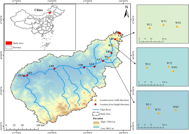
FIGURE 1. Distribution of sampling sites in the riparian zone of the Ulgai River. LA1/LA2: Source area; LB1/LB2: Upper reaches; LC1/LC2: Middle reaches; LD1/LD2: Lower reaches; LE1/LE2: Terminal lake; WL1/WL2/WL3: Low floodplain; WT1/WT2/WT3: Transition zone; WH1/WH2/WH3: High floodplain. The same is following Figures and Tables.
Three to five quadrats with a size of 0.5 m × 0.5 m were set up along the diagonal direction of each plot according to the composition of plant community types. Then the plant species, coverage, plant number, and plant height in the quadrats were recorded, and the above-ground parts of plants were mowed to determine their biomass. Due to long-term overgrazing and irrational land development in the middle and lower reaches of the river, the width of the riparian zone shrinked and its integrity became poor. Therefore, only the upstream with little human disturbance was selected as the typical study area for sampling. According to the field investigation, the vegetation types of the sample plots in the study area were determined on the basis of importance values (Table 1). After the investigation of the plant community, three points were taken along the diagonal with a soil sampler of 7 cm in diameter in each small quadrat, and samples from the 0–10 cm topsoil layer were collected and mixed evenly. After removing roots and stones, one portion was stored in a refrigerator at 4°C for the determination of ammonium nitrogen and nitrate nitrogen in the soil, and a second portion was sieved through different pore sizes (2 mm, 1 mm, and 0.15 mm) after drying naturally in a cool and ventilated location indoors. Then, seven soil chemical properties including the pH, electrical conductivity (EC), total carbon (TC), total nitrogen (TN), total phosphorus (TP), available phosphorus (AP), and soil organic carbon (SOC) were analyzed for the pretreated soil samples.
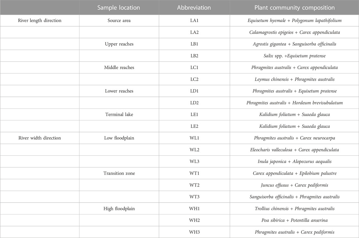
TABLE 1. Basic information of the plant community in the sample sites.
The richness index (R), Shannon–Wiener diversity index (H), Simpson dominance index (D), and Pielou’s evenness index (E) were selected to reflect plant diversity and the calculation formula is as follows:
In the formulas,
In this study, the following physical and chemical indexes of soil were analyzed: soil bulk density (BD, g/cm3), soil water content (SWC, %), pH, EC (μS/cm), TC (g/kg), TN (g/kg), TP (g/kg), ammonium nitrogen (mg/kg), nitrate nitrogen (mg/kg), AP (mg/kg), and SOC (g/kg).
SWC was determined using the oven-drying method (105°C) (Ministry of Environmental Protection of the People’s Republic of China, 2011a); BD was determined via cutting ring (Ministry of Agriculture of the People’s Republic of China, 2006b); pH and EC were determined using potentiometry (Ministry of Environmental Protection of the People’s Republic of China, 2016; Ministry of Ecology and Environment of the People’s Republic of China, 2018); TC and TN were determined using the CHN elemental analyzer (Vario MACRO Cube, Germany) (Jeong et al., 2021); TP was determined using the alkali fusion–Mo-Sb anti-spectrophotometric method (Ministry of Environmental Protection of the People’s Republic of China, 2011b); AP was measured using the hydrochloric acid, ammonium fluoride leaching/sodium bicarbonate leaching-molybdenum antimony anti-colorimetric method (Ministry of Agriculture of the People’s Republic of China, 2014); SOC was measured using the potassium dichromate oxidation external heating method (Ministry of Agriculture of the People’s Republic of China, 2006a); and ammonium nitrogen and nitrate nitrogen were determined using continuous flow analysis and the spectrophotometric method (SEAL AutoAnalyzer3, Germany) (Wang et al., 2017).
The data were organized and pre-processed using Excel, and then analysis of variance and multiple comparisons (LSD Duncan method) were performed for the soil physical and chemical properties and plant community diversity using SPSS 23.0, while Spearman correlation analysis was performed for soil physical and chemical properties. To further explore the relationship between plant species diversity and soil environmental factors in different spatial dimensions, this study selected four plant species diversity indices as response variables and 11 soil physicochemical properties as explanatory variables for redundancy analysis (RDA). The R package rdacca. hp was used to decompose the explanatory rate of each explanatory variable, and a negative single explanatory variable indicated that this variable had a negligible role in explaining the response variables. The statistical analysis of data and plotting were completed in Origin 2018 and R-4.1.3 (https://www.R-project.org/).
According to the investigation and statistics of vegetation types in the riparian zone of the Ulgai River, there were 87 species of wetland plants belonging to 65 genera of 24 families (Figure 2). The species richness of vegetation in this region was high, among which Asteraceae, Poaceae, Cyperaceae, Rosaceae, Ranunculaceae, and Fabaceae families were represented by many genera and species. These families constituted the co-dominant species of the plant community in the riparian zone and the main species in the riparian zone of the Ulgai River. Among the co-dominant species, there were 15 Asteraceae species, accounting for 17% of the total number of species; 13 Poaceae species, accounting for 15% of the total number of species; nine Cyperaceae species, accounting for 10% of the total number of species; eight Rosaceae species, accounting for 9% of the total number of species; five Ranunculaceae species, accounting for 6% of the total number of species; and four Fabaceae species, accounting for 5% of the total number of species, and the dominance of the dominant populations was not obvious. In different dimensions, there were obvious differences in the distribution of plant communities. The plant species in the upper reaches were the most abundant along the river length, with a total of 31 species belonging to 26 genera and 15 families, while the plant communities in the terminal lake were simple in structure and more homogeneous in species, with only three species belonging to three genera and two families. The plant community composition in the transition zone along the river width direction was the richest, with a total of 41 species belonging to 34 genera and 19 families, while the plant community in the low floodplain was relatively less diverse, totaling 29 species belonging to 26 genera and 14 families. Referring to the division of the geographical flora of spermatophytes in China by Wu (Wu, 1991), this study found that the distribution of plants in the study area was dominated by the cosmopolitan areal type and the north temperate type, accounting for 39% and 38% of the total number of plants, respectively. The floristic distribution showed that the species composition in the area was highly adaptable to climate and soil, highly resistant to cold, and highly resistant to disturbance, and the distribution of endemic Chinese species was relatively lacking.
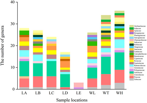
FIGURE 2. Distribution types and numbers of flora families and genera in wetlands along the riparian zone of the Ulgai River. LA, source area; LB, upper reaches; LC, middle reaches; LD, lower reaches; LE, terminal lake; WL, low floodplain; WT, transition zone; WH, high floodplain. The same is following Figures and Tables.
The plant diversity index in the riparian zone of the Ulgai River is shown in Table 2. The E in the river length direction has no significant response to habitat changes, and the trend of index changes was upper reaches > middle reaches > source area > lower reaches > terminal lake. The H, D, and R values had a specific variation trend under each gradient, showing that the difference between the upper and middle reaches was small, and both were slightly higher than those in the source and lower reaches, while the diversity index of the terminal lake was the lowest and was significantly different from the rest of the river. The species diversity index in the terminal lake was at a lower level with a single species composition, which was not conducive to the stable development of the community. There were no significant differences in the R, H, D, and E values in the river width direction, and the values of each index were large and fluctuated stably, indicating that the community type in this dimension was composed of multiple species, with rich species and complex composition.
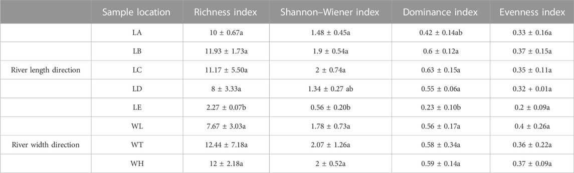
TABLE 2. Plant species diversity index of the wetlands in the riparian zone of the Ulgai River.
As shown in Figure 3, the soil physicochemical properties of each site in different dimensions and community types were significantly different: the source area was acidic soil, the upper, middle, and lower reaches were neutral to weakly alkaline, and the terminal lake was strongly alkaline due to serious soil salinization. The EC of the soil in the terminal lake was obviously higher than that in other reaches; the BD was higher in the lower reaches and terminal lake and lowest in the source; and the overall variation trend of the SWC was opposite to that of the BD. The variation trends of the TC, TN, and SOC were basically the same, and they were in the order of source > middle reaches > upper reaches > terminal lake and lower reaches. The TP content in the upper reaches and lower reaches was significantly lower than that in other reaches, and the AP content was the highest in the terminal lake and the lowest in the source. The content of ammonium nitrogen in soil was higher in the upper reaches than in other reaches, but relatively lower in the source and middle reaches, while the content of soil nitrate nitrogen was higher in the lower reaches and terminal lake but exhibited no significant differences in other reaches.

FIGURE 3. Physicochemical properties of soils in the riparian zone under different gradients: (A) pH; (B) electrical conductivity; (C) soil bulk density; (D) soil water content; (E) total carbon; (F) total nitrogen; (G) total phosphorus; (H) available phosphorus; (I) soil organic carbon; (J) ammonium nitrogen; (K) nitrate nitrogen. Different lowercase letters indicate significant difference (p < 0.05, analysis of variance).
There was no significant difference in the BD, TC, TN, TP, SOC, and nitrate nitrogen contents along the river width. The AP and pH in the low floodplain were significantly lower than those in the transition zone and high floodplain, while the SWC and ammonium nitrogen showed opposite trends. The EC in the transition zone was higher compared with the other two gradients.
As shown in Figure 4, the correlation and significance of soil physical and chemical properties in horizontal and vertical dimensions were not identical, but there were some similar patterns of variation. There were significant positive correlations between the TC and TN, pH and AP, pH and BD, TC and TP, and TN and TP, while there were significant negative correlations between the pH and SWC, nitrate nitrogen and SWC, and BD and SOC. In addition, there were significant positive correlations between the EC and AP, TC and SOC, and TN and SOC, and significant negative correlations between the AP and SWC, TC and BD, and SWC and BD.
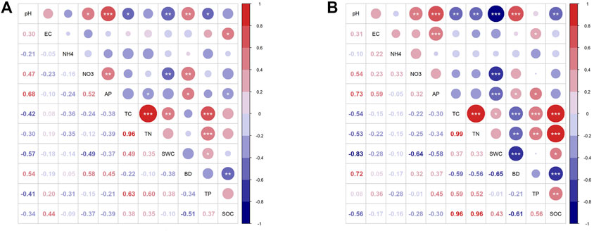
FIGURE 4. Spearman correlation analysis of soil physicochemical properties in the riparian zone: (A) river length direction; (B) river width direction. *: p < 0.1; **: p < 0.05; ***: p < 0.01; figures without * indicate p > 0.1. pH: pH value; EC: Electrical conductivity; BD: Soil bulk density; SWC, soil water content; TC, total carbon; TN, total nitrogen; TP, total phosphorus; AP, available phosphorus; SOC, soil organic carbon; NH4, ammonium nitrogen; NO3, nitrate nitrogen. The same is following Figures and Tables.
The RDA showed that the first two axes along river length could explain 98.5% of the plant diversity characteristics, and the RDA1 axis accounted for 94.17%. The interpretation rates of ammonium nitrogen, nitrate nitrogen, and EC were higher in sequence (Figure 5). The first two axes in the river width direction could explain 98.8% of the plant diversity characteristics, and the RDA1 axis accounted for 94.89%. The explanation rates of EC, SOC, and pH were higher in sequence. This indicated that the first two axes could reflect the vast majority of information on the relationship between soil physicochemical factors and plant diversity. The RDA1 axis in the river length direction was positively correlated with SWC and BD, but negatively correlated with the other soil physicochemical factors, and more correlated with SWC and ammonium nitrogen. The RDA1 axis in the river width direction was positively correlated with pH, SOC, and AP, and the correlation with SOC was the highest.
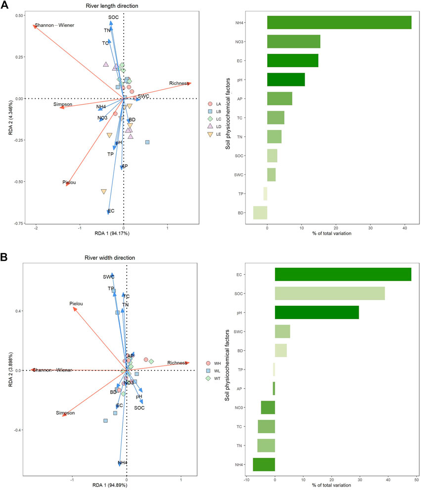
FIGURE 5. Redundancy analysis (RDA) ordination diagram of plant species diversity and soil physicochemical factors in the riparian zone wetlands and the results of variance partitioning: (A) river length direction; (B) river width direction.
According to the results of the species diversity survey, plants of the cosmopolitan areal types, such as Asteraceae and Poaceae, dominated the wetland ecosystem in the riparian zone of the Ulgai River. The analysis of the water ecotypes of the main plants revealed that the hygrophytes, such as Equisetum hyemale and Agrostis gigantea, dominated in the upper reaches; the middle and lower reaches were mainly inhabited by the meso-hygrophytes, such as Phragmites australis and Leymus chinensis, and the terminal lake was mainly populated by halophytes and xerophytes, such as Suaeda glauca and Kalidium foliatum. This showed that the vegetation types in different river reaches had significant differences, and the vegetation types in the riparian zone showed an obvious spatial succession pattern in the longitudinal gradient in the “sourceward zonation” distribution pattern of swamp meadow → typical herbaceous community → saline meadow. The results showed that the plant α-diversity on the longitudinal gradient showed an overall trend of increasing at first and then decreasing. The middle and upper reaches of the Ulgai River promoted the succession of wetland vegetation in the riparian zone and maintained species diversity due to good hydrothermal conditions and low anthropogenic interference. However, the terminal lake area is located in the Ulgai Gobi, where the lake has nearly dried up and the land type has been degraded from marshes to Gobi alkali beach. As a result, a small number of halophytes and xerophytes have become the dominant vegetation type and plant diversity has decreased significantly compared with other river reaches.
Among the three different zones along the river width, shallow water vegetation types such as Eleocharis valleculosa and Phragmites australis appeared in the low floodplain, and hygrophytes such as Carex appendiculata and Juncus effusus dominated in the transition zone, while mesoxerophytes such as Trollius chinensis and Poa sibirica growing on the high floodplain had gradually transitioned to grassland vegetation types in the terrace. In addition, this study found that there were fewer plant species in the low floodplain, while the species richness and diversity were the highest in the intermediate transition zone, which Tsheboeng (Tsheboeng, 2018) attributed to Connell’s moderate disturbance hypothesis. In general, as the distance from the river bank increased, the plant species gradually changed, and the hydrophytes and hygrophytes gradually decreased so that the wetland plant community of the river floodplain showed a distribution pattern of “shoreward zonation.”
Soil nutrient content and spatial distribution characteristics can comprehensively and scientifically reflect the habitat conditions (De Deyn and Kooistra, 2021). Along the length of the river, the pH and BD showed an overall upward trend and the SWC showed an obvious downward trend, most likely because the source soil was not transported and formed acidic soil through the process of weathering and the alluviation of basalt and mineralization and degradation of organic matter (Weil and Brady, 2017). The soil in the middle reaches and terminal lake was mostly composed of sediment deposition in the upper reaches, so the soil was neutral to alkaline. Due to serious salinization, the pH and EC values of the soil in the terminal lake were much higher than those of the other river reaches. The BD and SWC of the wetland were related to the hydroperiod of the soil. The soil in the riparian zone was in a long-term flooded state because the runoff flow of the source, middle, and upper reaches was large, so the proportion of fine particles in the soil was high and close to suspension. In addition, livestock repeatedly trample and compact the soil surface due to the high grazing intensity in the middle reaches and terminal lake area (Zhang and Nan, 2010). These factors jointly led to an overall upward trend of the BD and a downward trend of the SWC on the longitudinal gradient. In addition, the regularity of TC, TN, and SOC was basically the same, and the correlation analysis also showed that the three indicators were significantly and positively correlated. The source area of the river had various vegetation types and a large quantity of vegetation due to the distribution of birch forests, Salix shrubs, and Carex tussocks on both banks. Carex heterolepis and other plants had caused the accumulation of a large amount of litter on the soil surface (Sayer et al., 2021), so the TC, TN, and SOC contents were significantly higher than in the other river reaches. In addition, the AP content in the terminal lake of the river was significantly higher than that in the other river reaches, which may have been due to the lower phosphorus demand caused by the presence of less vegetation.
In the river width direction, the pH and AP content in the low floodplain were relatively low, and there was a significant positive correlation between them. Related studies showed that pH was critical to the release and effectiveness of phosphorus (Alori et al., 2017; von Tucher et al., 2018). The soil in the low floodplain was in a state of long-term water saturation, and frequent flooding caused more conversion of above-ground litter into organic matter, resulting in the continuous enrichment of organic matter in the soil (Zhang et al., 2018), which could explain the phenomenon of high water content and low pH in the low floodplain. In addition, this study found that the pH and TC were correlated with many other physicochemical factors in different landscape dimensions. Studies have shown that although pH did not directly indicate the content of a certain nutrient in the soil, its level not only could directly affect the existence form of various nutrient elements in the soil and their availability to plants (Wang and Zang, 2022) but also affected the transformation of most nutrient elements by changing the microflora in the soil (Fernandez-Calvino et al., 2011). The soil carbon sequestration represented by the TC could improve the stability of the soil structure and affect soil physicochemical and biological characteristics such as the water-holding capacity, the fertilizer-conserving capacity, and the cation exchange capacity. Soil carbon provides the energy for soil microbial life activities and facilitates the formation of all favorable soil environments (Delgado et al., 2013).
The vegetation–soil system is an inseparable whole and its complex interaction mechanisms maintain the dynamic stability of ecosystems (Silva and Lambers, 2021). The RDA conducted in this study showed that there was a correlation between the plant species diversity and soil physicochemical properties in the wetlands of the riparian zone under different landscape scales. The influences of soil ammonium nitrogen and nitrate nitrogen on plant communities along the river length were the most significant, indicating that the interaction between the soil nitrogen dynamics and plant community characteristics on the longitudinal gradient was great, and that was the dominant factor influencing the plant composition of wetlands in the riparian zone. The ability of transformation between soil ammonium and nitrate nitrogen differed among plant communities as affected by soil physicochemical properties (Ma et al., 2019). In the dimension of river width, the soil EC and SOC content become the most important constraints on plant species diversity in the riparian zone due to the elevation difference caused by microtopographic changes and the limitation of the distance from the river, which was consistent with the results of previous studies (Zhang et al., 2015; Zeng et al., 2020; Flores-Galicia et al., 2021). In addition, factors such as differences in the intensity of anthropogenic activities around the sample sites could affect the content of soil mineral nutrients, thereby affecting the composition and diversity of plant communities (Yang et al., 2022). The riparian zone was a dynamic ecosystem that was influenced by various natural and anthropogenic factors. Due to the different coupling relationships between habitats and the non-uniformity of patches under different landscape scales, the spatial distribution patterns of vegetation in the riparian zone showed significant spatial and temporal heterogeneity, and their formation and influencing factors were also different (Wang et al., 2014).
In the survey of wetland vegetation in the riparian zone of the Ulgai River, a total of 87 species belonging to 24 families and 65 genera of plants were recorded, and the plant composition and species diversity of the riparian zone in different landscape dimensions showed obvious spatial succession patterns. The soil physicochemical properties also differed significantly along different gradients in the riparian wetland of the Ulgai River, where the SWC, pH, and TC were correlated with multiple physicochemical factors. The soil ammonium nitrogen and nitrate nitrogen along the river length direction and the EC and SOC along the river width direction were the dominant factors affecting plant diversity and vegetation distribution in the study area. The riparian zone is a system in which soil, plants, microorganisms, water, solutes, and other elements interact and are closely linked. Based on this, exploring the coupling influence mechanism of each element in the riparian zone system will be the focus and challenge of future research.
The original contributions presented in the study are included in the article/Supplementary Material, further inquiries can be directed to the corresponding authors.
LM: Conceptualization, methodology, data processing, formal analysis, visualization, writing-original draft, review and editing; RF: Investigation, writing—review and editing; HL: Supervision, and project administration; RZ: Investigation, formal analysis, writing—review and editing; ZX: Investigation, writing—review and editing; XC: Investigation, writing—review and editing; XL: Investigation, writing—review and editing; LW: visualization; YZ: Investigation, writing—review and editing; LW: Conceptualization, investigation, methodology, review and editing, resources, validation, funding acquisition and project administration. All authors have agreed to be responsible for the content of the paper and approved it for publication.
This work is funded by the National Natural Science Funds, P.R. China (No. 32161143025, 32160279, 31960249), Science and Technology Major Project of Inner Mongolia (No. 2022YFHH0017, 2021ZD0011), the Funds of Yinshanbeilu Grassland Eco-hydrology National Observation and Research Station (No. YSS2021007) and Ordos Science and Technology Plan (No. 2022EEDSKJZDZX010).
The authors declare that the research was conducted in the absence of any commercial or financial relationships that could be construed as a potential conflict of interest.
All claims expressed in this article are solely those of the authors and do not necessarily represent those of their affiliated organizations, or those of the publisher, the editors and the reviewers. Any product that may be evaluated in this article, or claim that may be made by its manufacturer, is not guaranteed or endorsed by the publisher.
Allen, D. C., Datry, T., Boersma, K. S., Bogan, M. T., Boulton, A. J., Bruno, D., et al. (2020). River ecosystem conceptual models and non-perennial rivers: A critical review. WIREs Water 7 (5), e1473. doi:10.1002/wat2.1473
Alori, E. T., Glick, B. R., and Babalola, O. O. (2017). Microbial phosphorus solubilization and its potential for use in sustainable agriculture. Front. Microbiol. 8, 971. doi:10.3389/fmicb.2017.00971
Bai, Y. F., Wu, J. G., Pan, Q. M., Huang, J. H., Wang, Q. B., Li, F. S., et al. (2007). Positive linear relationship between productivity and diversity: Evidence from the eurasian steppe. J. Appl. Ecol. 44 (5), 1023–1034. doi:10.1111/j.1365-2664.2007.01351.x
Ballantine, K., and Schneider, R. (2009). Fifty-five years of soil development in restored freshwater depressional wetlands. Ecol. Appl. 19 (6), 1467–1480. doi:10.1890/07-0588.1
Chen, P. P., Liu, H. M., Wang, Z. M., Mao, D. H., Liang, C. Z., Wen, L., et al. (2021). Vegetation dynamic assessment by NDVI and field observations for sustainability of China's wulagai River Basin. Int. J. Environ. Res. Public Health 18 (5), 2528. doi:10.3390/ijerph18052528
De Deyn, G. B., and Kooistra, L. (2021). The role of soils in habitat creation, maintenance and restoration. Philos. T. R. Soc. B 376, 20200170. doi:10.1098/rstb.2020.0170
Delgado, J. A., Nearing, M. A., and Rice, C. W. (2013). “Chapter two - conservation practices for climate change adaptation,” in Advances in agronomy. Editor D. L. Sparks (Academic Press), 47–115.
Fernandez-Calvino, D., Rousk, J., Brookes, P. C., and Baath, E. (2011). Bacterial pH-optima for growth track soil pH, but are higher than expected at low pH. Soil Biol. biochem. 43 (7), 1569–1575. doi:10.1016/j.soilbio.2011.04.007
Flores-Galicia, N., Trejo, I., and Ramirez-Marcial, N. (2021). Environment-driven changes in diversity of riparian plant communities along a mountain river. Ecol. Evol. 11 (10), 5690–5701. doi:10.1002/ece3.7472
Gurnell, A. M., Edwards, P. J., Petts, G. E., and Ward, J. V. (2000). A conceptual model for alpine proglacial river channel evolution under changing climatic conditions. Catena 38 (3), 223–242. doi:10.1016/s0341-8162(99)00069-7
Han, W., Chen, L., Su, X., Liu, D., Jin, T., Shi, S., et al. (2022). Effects of soil physico-chemical properties on plant species diversity along an elevation gradient over alpine grassland on the qinghai-Tibetan plateau, China. Front. Plant Sci. 13, 822268. doi:10.3389/fpls.2022.822268
Haq, S. M., Malik, Z. A., and Rahman, I. U. (2019). Quantification and characterization of vegetation and functional trait diversity of the riparian zones in protected forest of Kashmir Himalaya, India. Nord. J. Bot. 37 (11), njb.02438. doi:10.1111/njb.02438
Jeong, D., Jeong, W., Baeg, S., and Kim, J. (2021). Datasets on the spatial distribution of mercury and its controlling factors in the Yellow Sea. Data Brief. 35, 106792. doi:10.1016/j.dib.2021.106792
Ma, Y. P., Li, Y. H., and Abdulzheman, N. (2019). Temporal and spatial distribution characteristics of soil ammonium and nitrate nitrogen in different plant communities in the ebinur lake wetland. Henan Sci. Technol. (26), 150–156. (in Chinese).
Ministry of Agriculture of the People's Republic of China (2006a). “Soil testing,” in Part 6: Method for determination of soil organic matter (Beijing: China Agricultural Press). NY/T 1121.6-2006.
Ministry of Agriculture of the People's Republic of China (2006b). “Soil testing,” in Part4: Method for determination of soil bulk density (Beijing: China Agricultural Press). NY/T 1121.4-2006.
Ministry of Agriculture of the People's Republic of China (2014). “Soil testing,” in Part 7: Method for determination of available phosphorus in soil (Beijing: China Agricultural Press). NY/T 1121.7-2014.
Ministry of Ecology and Environment of the People's Republic of China (2018). Soil-Determination of pH-Potentiometry. Beijing: China Environmental Science Press. HJ 962-2018).
Ministry of Environmental Protection of the People’s Republic of China (2011a). “HJ 613-2011),” in Soil-Determination of dry matter and water content-Gravimetric method (Beijing: China Environmental Science Press).
Ministry of Environmental Protection of the People’s Republic of China (2016). “HJ 802-2016),” in Soil quality-Determination of conductivity-Electrode method (Beijing: China Environmental Science Press).
Ministry of Environmental Protection of the People’s Republic of China (2011b). Soil-Determination of Total Phosphorus by alkali fusion-Mo-Sb Anti spectrophotometric method. Beijing: China Environmental Science Press. HJ 632-2011).
Nilsson, C., and Svedmark, M. (2002). Basic principles and ecological consequences of changing water regimes: Riparian plant communities. Environ. Manage 30 (4), 468–480. doi:10.1007/s00267-002-2735-2
Sayer, E. J., Baxendale, C., Birkett, A. J., Brchet, L. M., Castro, B., Kerdraon-Byrne, D., et al. (2021). Altered litter inputs modify carbon and nitrogen storage in soil organic matter in a lowland tropical forest. Biogeochemistry 156 (1), 115–130. doi:10.1007/s10533-020-00747-7
Sha, R. N. (2015). The ecological risk evaluation based on ulgai River Basin of Xllingol League. Master Thesis. Hohhot: Inner Mongolia Normal University (in Chinese).
Shang, C. W., and Wu, J. G. (2022). A legendary landscape in peril: Land use and land cover change and environmental impacts in the Wulagai River Basin, Inner Mongolia. J. Environ. Manage. 301, 113816. doi:10.1016/j.jenvman.2021.113816
Silva, L. C. R., and Lambers, H. (2021). Soil-plant-atmosphere interactions: Structure, function, and predictive scaling for climate change mitigation. Plant Soil 461 (1), 5–27. doi:10.1007/s11104-020-04427-1
Subuda,, , Yi, J., Chen, J. Q., Bao, X. X., and Sanasiqin, (2011). Analysis of vegetation degeneration succession trend in middle and lower reaches of wulagai wetland of inner Mongolia. Chin. J. Grassl. 33 (3), 73–78. (in Chinese).
Tsheboeng, G. (2018). Spatial variation of the influence of distance from surface water on riparian plant communities in the Okavango Delta, Botswana. Ecol. Process. 7, 32. doi:10.1186/s13717-018-0140-x
von Tucher, S., Hoerndl, D., and Schmidhalter, U. (2018). Interaction of soil pH and phosphorus efficacy: Long-term effects of P fertilizer and lime applications on wheat, barley, and sugar beet. Ambio 47, 41–49. doi:10.1007/s13280-017-0970-2
Wang, L. X., Liu, H. M., Liu, Y. H., Liang, C. Z., Wang, W., Liu, D. W., et al. (2014). Introduction to the concept, foundation and focuses of riverscape ecology. Wetl. Sci. 12 (02), 228–234. (in Chinese).
Wang, L. X. (2012). The spatial distribution of wetland vegetation and its ecological process and function on riparian zone of riverscape in inner Mongolia grassland. doctoral dissertation. Hohhot: Inner Mongolia University. (in Chinese).
Wang, S. F. (2013). Reaserch on in recent 20 years of vegetation cover change inner Mongolia ulgai river basin. Master Thesis. Hohhot: Inner Mongolia Normal University. (in Chinese).
Wang, Y. S., Liu, Y. S., Liu, R. L., Zhang, A. P., Yang, S. Q., Liu, H. Y., et al. (2017). Biochar amendment reduces paddy soil nitrogen leaching but increases net global warming potential in Ningxia irrigation, China. Sci. Rep. 7, 1592. doi:10.1038/s41598-017-01173-w
Wang, Y. T., and Zang, S. Y. (2022). The pH distribution and soil nutrient characteristic at different habitats-A case study of momoge wetland. J. Anhui Agric. Sci. 50 (05), 135–139. (in Chinese).
Wu, J. G., and Loucks, O. L. (1992). Grasslands and grassland sciences in northern China. Washington, DC: The National Academies Press.
Wu, J. G., Zhang, Q., Li, A., and Liang, C. Z. (2015). Historical landscape dynamics of inner Mongolia: Patterns, drivers, and impacts. Landsc. Ecol. 30 (9), 1579–1598. doi:10.1007/s10980-015-0209-1
Wu, Z. Y. (1991). The areal-types of Chinese genera of seed plants. Acta Bot. Yunnanica (S4), 1–139. (in Chinese).
Xia, J. H., Hu, L., and Pu, Q. C. (2008). “EDGE-EFFECT of ecological riparian zone,” in 16th Asia and pacific division Congress of the international Association of hydraulic Engineering and research/3rd IAHR international Symposium on hydraulic structures), 465. +.
Yang, H. Y., Xing, Q., Bao, W. Y., Liu, Y. L., De, L. H., H., Y. X., et al. (2018). Study on the geographical distribution of wild plants in wulagai grassland. Grassl. Pratac. 30 (04), 28–34. (in Chinese).
Yang, J., Li, E., Zhou, R., Xia, Y., Yang, C., and Zhang, Y. (2022). The effects of edaphic factors on riparian plants in the middle and lower reaches of the hanjiang river, China. Plants 11 (4), 531. doi:10.3390/plants11040531
Young-Mathews, A., Culman, S. W., Sánchez-Moreno, S., Toby O’Geen, A., Ferris, H., Hollander, A. D., et al. (2010). Plant-soil biodiversity relationships and nutrient retention in agricultural riparian zones of the Sacramento Valley, California. Agrofor. Syst. 80 (1), 41–60. doi:10.1007/s10457-010-9332-9
Zeng, Y., Zhao, C., Shi, F., Schneider, M., Lv, G., and Li, Y. (2020). Impact of groundwater depth and soil salinity on riparian plant diversity and distribution in an arid area of China. Sci. Rep. 10 (1), 7272. doi:10.1038/s41598-020-64045-w
Zhang, C. X., and Nan, Z. B. (2010). Research progress on effects of grazing on physical and chemical characteristics of grassland soil. Acta pratac. Sin. 19 (04), 204–211. (in Chinese).
Zhang, L. C., Cao, L., Li, Y. Y., Li, Y. S., Han, X. M., and Zhu, X. H. (2018). Soil acidity and alkalinity in the new water-level fluctuation zone of danjiangkou reservoir and the influence by vetiveria zizanioides cultivation. Wetl. Sci. 16 (03), 334–340. (in Chinese). doi:10.13248/j.cnki.wetlandsci.2018.03.008
Zhang, X. N., Lü, G. H., Wang, T. Q., Ma, Y., Abliz, A., Zhao, X. Y., et al. (2015). Patterns and mechanisms influencing plant diversity in an arid desert region riparian zone of the Aqikesu River, Xinjiang, China. Acta Ecol. Sin. 35 (18), 5966–5974. (in Chinese).
Keywords: riverscape, inland river, riparian zone, plant diversity, soil physicochemical properties
Citation: Ma L, Fu R, Liu H, Zhang R, Xu Z, Cao X, Liu X, Wen L, Zhuo Y and Wang L (2023) Spatial variation patterns of vegetation and soil physicochemical properties of a typical inland riverscape on the Mongolian plateau. Front. Environ. Sci. 11:1134570. doi: 10.3389/fenvs.2023.1134570
Received: 30 December 2022; Accepted: 30 January 2023;
Published: 09 February 2023.
Edited by:
Changchun Huang, Nanjing Normal University, ChinaReviewed by:
Dehua Mao, Northeast Institute of Geography and Agroecology, Chinese Academy of Sciences, ChinaCopyright © 2023 Ma, Fu, Liu, Zhang, Xu, Cao, Liu, Wen, Zhuo and Wang. This is an open-access article distributed under the terms of the Creative Commons Attribution License (CC BY). The use, distribution or reproduction in other forums is permitted, provided the original author(s) and the copyright owner(s) are credited and that the original publication in this journal is cited, in accordance with accepted academic practice. No use, distribution or reproduction is permitted which does not comply with these terms.
*Correspondence: Huamin Liu, MTExOTczMzA4QGltdS5lZHUuY24=, Lixin Wang, bHh3YW5nQGltdS5lZHUuY24=
Disclaimer: All claims expressed in this article are solely those of the authors and do not necessarily represent those of their affiliated organizations, or those of the publisher, the editors and the reviewers. Any product that may be evaluated in this article or claim that may be made by its manufacturer is not guaranteed or endorsed by the publisher.
Research integrity at Frontiers
Learn more about the work of our research integrity team to safeguard the quality of each article we publish.