 Guoming Du
 Jing Xie
 Dawei Hou
 Fengrong Yu2
95% of researchers rate our articles as excellent or good
Learn more about the work of our research integrity team to safeguard the quality of each article we publish.
Find out more
ORIGINAL RESEARCH article
Front. Environ. Sci. , 29 March 2023
Sec. Land Use Dynamics
Volume 11 - 2023 | https://doi.org/10.3389/fenvs.2023.1134271
This article is part of the Research Topic Agricultural Land and Environmental Risks: Evidence, Assessment and Conservation Transition View all 15 articles
Scientific understanding of the connotation of Green Use of Cultivated Land (GU-CL) is important to promote sustainable use of cultivated land. This study aims to analyze the regional heterogeneity of the Green Use Level of Cultivated Land (GUL-CL) in Heilongjiang Reclamation Area (HRA). Using entropy power method and coupled coordination degree model, statistical analysis was carried out based on the data of the HRA in 2020. The results show that the degree of GUL-CL in the study area is generally well-developed, but internal differences exist. Specifically, the GUL-CL ranges from 0.590 to 38.179, with a mean value of 8.818. Additionally, 29.204% of the total farms are above the higher level, mainly in Jiansanjiang and Baoquanling. In environmental friendliness practices, the high-level areas are concentrated primarily on the Songnen Plain Reclamation Area. Or, the Sanjiang Plain Reclamation Area positively presents significant effects on resource conservation. In the study area, spatial intensification and output efficiency are relatively balanced. The coupling coordination degree of green use of cultivated land (GU-CL) (0.20–0.50) is at a low coupling coordination stage. Consequently, this study can provide practical knowledge for the GU-CL in the black soil region of Northeast China.
China has achieved food security by investing large investments in labor and technology for cultivated land use over the past three decades (Chai et al., 2023). However, the large amount of elemental input has caused increasingly serious negative environmental impacts on cultivated land (Zambon et al., 2017; Zhou et al., 2021). For example, continuous fertilizer and pesticide use have caused soil acidification, erosion, water pollution, and other negative environmental impacts (German et al., 2017; Yu et al., 2019; Ye et al., 2022). With the introduction of the UN Sustainable Development Goals (SDGs) (especially Goals 12 and 13) and the “green” transformation of the food system (Yue et al., 2022), there is an urgent need to comprehensively assess and upgrade the green development of China’s cultivated land (Bryan et al., 2018).
The report of the 19th National Congress of the Communist Party of China points out that “we will unswervingly implement the new development concept and form a green way of development and lifestyle.” In the same perspective, “The 14th Five-Year Plan again emphasizes the promotion of green development, the comprehensive green transformation of economic and social development, and the construction of a modernization in which people and nature live harmoniously. Green use of cultivated land is the focus of green development. It is a fundamental principle that must be adhered to and implemented in current land use and management, affecting global environmental change and sustainable development of regional society and economy (Lai et al., 2020; Ma et al., 2020).
Green use of cultivated land is based on the natural properties of land, but its essence is the social phenomenon of using land (Wei et al., 2021). Green utilization requires not only the support of natural science but also the change of concept and the adjustment of social relations.
Currently, many scientific studies on GU-CL framework construction focus on the factors such as the triple types population-economic-social-environment (ke et al., 2021) and environment-resource-ecology-quality (Yu et al., 2022; Chai et al., 2023). (Note: In this paper, we use GU-CL to refer to the green use of cultivated land, and in quantifying the change in GU-CL, we use GUL-CL to refer to the level of green use of cultivated land). Meanwhile, many studies related to the GU-CL concept have evaluated and investigated the quality of cultivated land, sustainable use of cultivated land (Peltonen-Sainio et al., 2019; Li et al., 2023), and ecological security of cultivated land (Chen et al., 2021). The focus is on selecting relevant indicators by measuring the conceptual relationships between environmental risks, functions, or ecosystem services of cultivated land (Rinot et al., 2019; Ye et al., 2022). In general, there are three main indicators: (1) The degree of land use sustainability or efficiency by screening the mobile elements (labor, technology, capital, etc.) in the cultivated land system using the cultivated land input-output relationship. This situation mainly includes the intensity of fertilizer or pesticide use, effective irrigated area, multi-crop index, food production, agricultural yield, and carbon emissions (Kuang et al., 2020; Lu et al., 2020). (2) The health of the cultivated land system is determined by selecting the level of socio-environmental governance and technological control attached to the cultivated land system. This context mainly includes irrigation and drainage conditions, accessibility of field roads, level of disaster prevention and control, and level of agricultural mechanization (Ye et al., 2022; Zhang et al., 2022). (3) Reflecting the government’s support and intensification of cultivated land through national policies and implementation of land improvement (Ke et al., 2021). This category includes energy conservation and environmental protection expenditure, investment in fixed assets, agricultural land for facilities, and cultivated land replanting index.
The above focuses on the green dynamics of cultivated land use, which provides an important reference for accurately grasping the connotation and essentials of GU-CL, evaluation methods, and path selection. However, the fragmented explanatory mechanism of the existing literature fails to reveal the core meaning of GU-CL. Cultivated land is an artificial utilization system with multiple attributes, such as natural, social, and economic environments (Li and Liu, 2021). Existing evaluations have paid more attention to people’s material demand for cultivated land utilization and the core productive function of cultivated land (Song et al., 2022). To a large extent, the environmental impact of cultivated land and the spatial intensification of cultivated land should also be considered in the index system, such as organic fertilizers, green pesticides, and high-standard farmland, to form a more scientific evaluation index.
As one of the four predominantly black soil areas worldwide, the Northeast Black Soil Region is an important commercial grain production base in China. Due to long-term high-intensity and unreasonable utilization and excessive input of agricultural production chemicals, the natural fertility of black land has been decreasing year by year (Liu et al., 2010; Xu, 2019). The black soil area in northeast China has been gradually transformed from an “ecological functional area” to an “ecological fragile area.” Heilongjiang Reclamation Area is located in the Northeast Black Soil’s core and has modernized agriculture (Note: this article use HRA to refer to the Heilongjiang Reclamation Area). When General Secretary Xi Jinping visited the HRA in September 2018, he clearly pointed out the need to accelerate the development of green agriculture, adhere to the combination of use and nourishment, and take adequate measures to protect the black land. At the beginning of the 21st century, HRA started to build a national ecological demonstration area, insisting on a “high quality, green and safe” orientation and taking green actions such as “weight loss, drug, and herbicide reduction,” rapidly improving the ecological safety of cultivated land. In 2010, HRA was named as “National Modernized Large Agricultural Demonstration Area.” Therefore, the region could serve as a ‘natural experiment’ to understand the level of green use of modern agricultural land, which has specific significance for black soil conservation and provides an excellent example of the sustainable development goals of the Northeast Black Soil Region.
Because it provides a practical basis for carrying out GU-CL in the black soil area of northeast China, this research chose HRA as a case study. The main objective of this study was to clarify the concept and connotation of GU-CL and to explore GUL-CL characteristics and regional differences. The data used in this study were collected from the HRA database in 2021. Based on research data, we used the entropy weight method and coupled coordination model to analyze the regional characteristics and degree of coordination of GUL-CL. Our specific research objectives were to (1) establish the assessment system of GU-CL following defining the concept, (2) comprehensively explore the characteristics and regional differences of GUL-CL in HRA, and (3) analyze the characteristics of coupled coordination degree of GU-CL.
Heilongjiang Reclamation Area (HRA) is located in the four major black soil belts in the world, between 123°40′–134°40′E and 40°10′–50°20′N, mainly in the Songnen Plain and the Sanjiang Plain. It has nine branches and 113 farms, involving 74 counties in 12 cities in Heilongjiang Province (Figure 1). The Sanjiang Plain Reclamation Area is located in the humid and semi-humid low plains, with four branches in Baoquanling, Hongxinglong, Jiansanjiang, and Mudanjiang. The Songnen Plain Reclamation Area is located in a black soil area of China with a diffuse river and mango landscape, with five branches in Beian, Jiusan, Qiqihar, Suihua, and Harbin (Du et al., 2021). In 2020, the cultivated land area was 2.972 million hm2, of which 2.893 million hm2 will be sown with grain crops, and the total grain output will reach 21.340 million tons. The agricultural machinery rate was 99.70% in 2020 (accessed on 15 October 2022, at https://data.cnki.net). Since the beginning of the twenty-first century, HRA has taken several measures to carry out ecological agriculture. For instance, the most important actions were the development of low-carbon agriculture, the promotion of no-till technology, and the return of straw to the field. In addition, previous studies highlighted the launch of the “three reductions” work and the appropriate use of resources and other measures. The main goal is to improve the quality of agricultural products and ensure national food security.
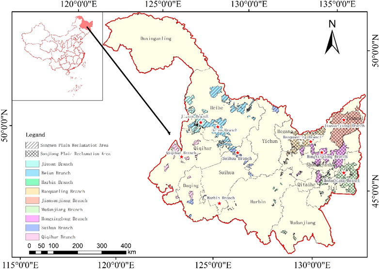
FIGURE 1. Heilongjiang Reclamation Area spatial distribution map.
This study was based on 2000–2020 land use data derived from the 1:100,000 national land use database of the Chinese Academy of Sciences (accessed on 26 January 2022, at https://www.resdc.cn). This land use database is combined with multivariate remote sensing image data for human-computer interactive interpretation and then verified by field survey and sampling, with an accuracy of more than 95% (Ning et al., 2018).
The data involved in this paper are organic fertilizer application intensity, green pesticide application intensity, straw return area ratio, conservation tillage area ratio, water-saving irrigation area ratio, surface water substitution for groundwater, agricultural electricity intensity, the total power of agricultural machinery per land unit, unmanned farming area, high-standard cultivated land coverage, multiple cropping index, total agricultural output value, total plantation output value, and plantation population. These data came from the Heilongjiang Reclamation Area Statistical Yearbook (2021) (accessed on 15 June 2022, at https://data.cnki.net) and the economic and social statistical synopsis of Beidahuang Group in 2020.
Cultivated land is an important natural resource, and its exploitation is an agricultural production activity in which people use inputs for a specific purpose. At the same time, “green” is a dynamic orientation to change to a green development mode, which is a “green” transformation of the original behavior pattern (Zou, 2019). With the development of the social economy, food safety, environmental health, and landscape recreation have become the focus of urban and rural residents’ needs. The ecological value of cultivated land has become prominent (Ke et al., 2021), and agricultural production needs to change from a high-input, high-output model to a sustainable and intensive one (Ye et al., 2020).
GU-CL is an inevitable requirement for green agricultural development and an essential means of ecological civilization construction. Scientific evaluation is based on a clear understanding of the idea of GU-CL, which is also the key to making sustainable use of cultivated land resources. Based on the above knowledge, the green development concept of harmonious coexistence between humans and nature and sustainable development is introduced into the process of cultivated land use, and a preliminary understanding of the GU-CL is formed.
Based on this context, the GU-CL is intended to change the traditional way of using cultivated land. Which is “high input, high consumption, and high pollution,” and to use modern advanced agricultural technology to promote safe, high-quality, and efficient output from cultivated land. It will reduce the environmental pollution caused by using cultivated land, eliminating the excessive use of natural resources. Simultaneously, it may transform the agricultural development mode, optimize the use of spatial structure, and promote the formation of a new pattern of high-quality farm development with a suitable ecological environment, resource conservation, intensive spatial management, and high-quality product supply. Figure 2.
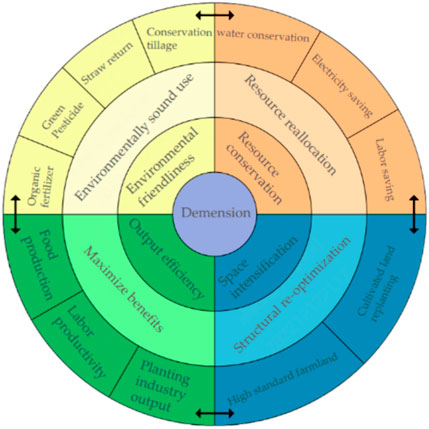
FIGURE 2. Green use of cultivated land concept diagram.
Environmental friendliness and resource conservation are the basic features of GU-CL, space intensification is the means of GU-CL, and output efficiency is the goal of GU-CL. Environmental friendliness and resource conservation are related to green utilization and low-carbon development. Resource conservation and space intensification are in the relationship of scale operation and resource conservation. The relationship between spatial intensification and output efficiency is related to enhanced intensive land use, which increases food production. Or the relationship between output efficiency and environmental friendliness presents the relationship between a green environment and high-quality products. The ultimate goal of GU-CL is to achieve high efficiency, green and high output of cultivated land.
The premise of establishing the indicator system must comply with scientific, systematic, understandable, and operable principles. In this study, regarding the existing studies of relevant scholars (Ke et al., 2021; Chai et al., 2023) and according to the actual situation of cultivated land use in the HRA, the focus is on the construction of the indicator system of GU-CL in four aspects: environmental friendliness, resource conservation, spatial intensification, and output efficiency (Table 1).
(1) Environmental friendliness. This study’s understanding of environmental friendliness is the homogeneity and unity of agricultural development and resource environmental protection, as well as the harmony and balance of agricultural development’s quantitative and qualitative benefits. Through adopting green production techniques such as organic fertilizers, and green pesticides, the nutrient content of the soil is improved, and the negative impact of the agricultural production process on the environment is reduced. The adoption of conservation tillage and straw return tillage is conducive to reducing soil erosion (Harper et al., 2018) and improving the carrying capacity of the regional agricultural environment. Therefore, the intensity of organic fertilizer application, green pesticide application, straw return ratio, and conservation tillage ratio are selected to characterize environmental friendliness.
(2) Resource conservation. Resource conservation is the primary feature of green development in agriculture, which is to obtain the maximum agricultural profit by minimizing resource consumption and improving resource allocation efficiency. The level of agricultural mechanization is an important manifestation of agricultural modernization. Still, the consumption of energy and resources from agricultural machinery is too high, and the use of large farm machinery in HRA has led to the aggravation of soil slabbing. Affected by the persistently high price of coal, many regions take measures to pull the plug and restrict electricity, affecting agricultural production. With increasing rice cultivation in HRA, groundwater resources are continuously stressed. Unmanned farming can realize smart agriculture, improving operational efficiency and saving planting costs (Wang et al., 2021). Therefore, the total power of agricultural machinery per land, agricultural electricity intensity, surface water replacement for groundwater irrigation, the proportion of water-saving irrigation areas, and the proportion of unmanned farming are selected to characterize resource saving.
(3) Space intensification. There are few high-quality cultivated land resources and insufficient cultivated land reserve resources. Hence, to ensure national food security and meet human demand for agricultural products, the only way to achieve the dual purpose of increasing production and saving land is to explore cultivated land. Also, it depends on optimizing the structure of cultivated land use and promoting the optimal allocation of cultivated land resources. High-standard cultivated land is permanent core cultivated land with flat land that is concentrated and continuous, matching cultivated land and fertile soil, which can maximize the use of high-quality cultivated land resources and increase food production. Therefore, the multiple cropping index and the high standard farmland coverage rate are selected to characterize the spatial intensification dimension.
(4) Output efficiency. Output efficiency is the direct goal of the green use of cultivated land. It is an important driver of the green use of cultivated land, emphasizing the balance between quantity and output quality. The total output value of the planting industry and food production reflect a region’s cultivated land production capacity and are important ways to reflect the output efficiency of cultivated land. In the context of labor demonetization, the increase in labor productivity can compensate for the impact of the agricultural labor shortage. Therefore, the average land value of gross plantation output, the average land value of grain production, and labor productivity are selected to characterize output efficiency.
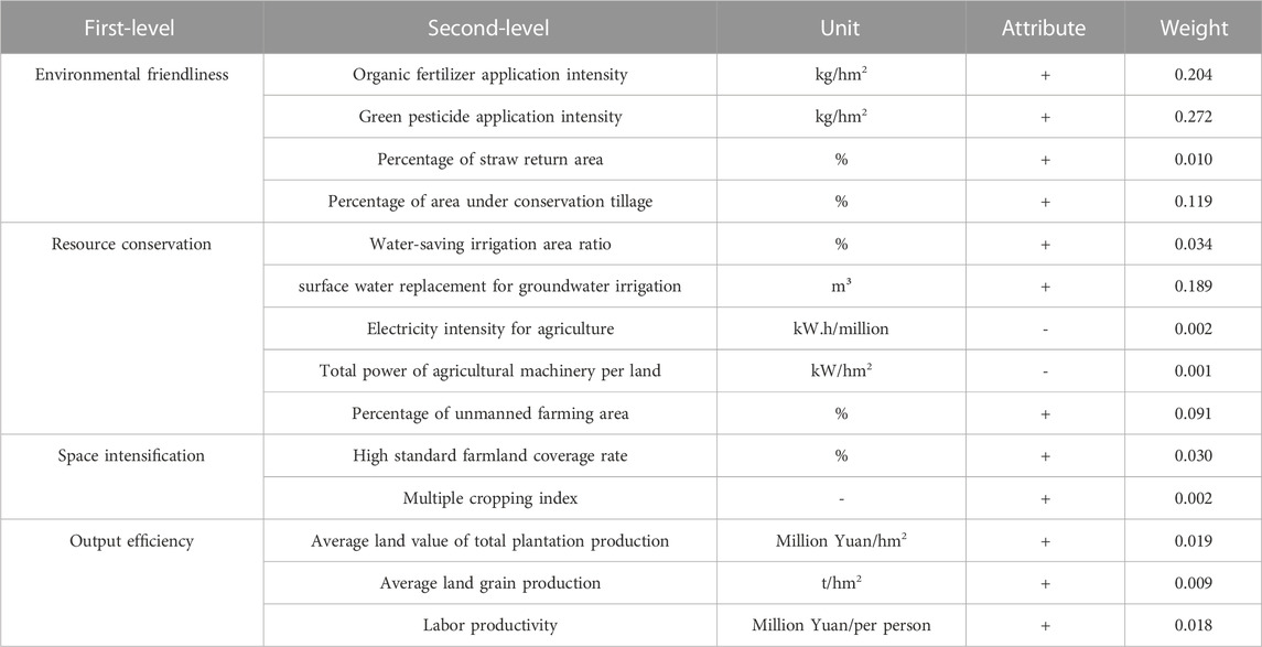
TABLE 1. Construction of the GUL-CL in the Heilongjiang reclamation area (HRA).
According to the positive and negative efficacy and importance of the evaluation indexes, the raw data of each index were normalized using the polar difference standardization method, and the values were taken in the range [0, 1].
Step 1:. Standardization of indicators:
Where: Iij is the standardized value of indicator j of the i sample, i = 1, 2, 3,
The standardized values and index weights were multiplied and summed based on data standardization to measure the environmental friendliness, resource conservation, spatial intensification, output efficiency, and comprehensive level of GU-CL. The specific formulas are as follows.
Where:
GU-CL is an integrated system consisting of four subsystems: environmental friendliness, resource conservation, spatial intensification, and output efficiency, and the subsystems present a correlation relationship of interaction and mutual constraints with each other.
The coupling degree is a response to the influence relationship between the subsystems with each other, focusing on the strength of the interaction relationship between the subsystems (Zambon et al., 2017; Dong et al., 2021). However, the coupling degree only emphasizes the interaction relationship between subsystems. In contrast, the coupling coordination degree can reflect the overall coordinated development of subsystems and reflect the degree of contribution of subsystems to the development of the system (Yang et al., 2020). Therefore, the coupling coordination degree is introduced to reflect the overall coordinated development of GU-CL. The coupled coordination degree model is as follows:
In this formula, C is the coupling degree. D is the coupling coordination degree. T is the comprehensive reconciliation index of the four subsystems of green use of cultivated land. U1, U2, U3, and U4 represent the evaluation values of environment-friendly, resource-saving, space-intensive, and output-efficient subsystems; a, b, c, and d are the parameters to be evaluated, and a + b + c + d = 1. The paper considers that the four significant systems are equally crucial for the green use of cultivated land, so a, b, c, and d are taken as 0.25. Concerning the relevant research results (Xu et al., 2020) and combined with the actual paper, the coupling degree is divided into four types (Table 2), and the coordination degree is divided into six classes (Table 3).

TABLE 2. The classification of coupling degree.
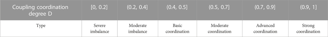
TABLE 3. The classification of coupling coordinating degree.
According to the results of the single-factor evaluation of GU-CL, there are obvious differences in different GU-CL indicators in the same region (Figure 3). At the level of environmental friendliness, there are obvious differences in organic fertilizer, green pesticide application intensity, and conservation tillage. Qiqihar has outstanding performance in organic fertilizer and green pesticide application intensity, accounting for 76.663% and 45.143% of the total value. Conversely, the lowest is Baoquanling, with 0.641% and 0.089% of organic fertilizer and green pesticide application intensity. The highest percentage of conservation tillage in Jiu San reached 34.909%, and the lowest was Mudanjiang, with 0.979%. Since 2008, China has prioritized the return of straw to the field. Each branch has a high proportion of straw return to the area, with Qiqihar and Baoquanling achieving all straw return to the field and Harbin having a relatively low rate of straw return to the field. At the level of resource conservation, the ratio of water-saving irrigation area varies widely among branches, and the ratio of water-saving irrigation area in Jiansanjiang accounts for 17.634% of the total value. Or the lowest is registered in Beian at 0.454%. All branches except Suihua take surface water to replace groundwater, of which Jiansanjiang is the highest, accounting for 79.220% of the total value. Jiansanjiang (17.379%) and Hongxinglong (17.218%) counties have the highest agricultural electricity intensity per unit area, superior to the average of 11.111%.

FIGURE 3. The green use factors of cultivated land in HRA (%).
In contrast, Jiusan (5.56) and Qiqihaer (5.87) have the lowest, inferior to the average. The total power of agricultural machinery was the highest in Baoquanling, accounting for 16.905% of the total value; conversely, the lowest was in Beian, accounting for 5.767% of the total value. The proportion of unmanned farming varies significantly, with Jiansanjiang and Mudanjiang at more than 23.404% and Qiqihar at the lowest, accounting for only 1.959% of the total value.
At the level of spatial intensification, the coverage rate of high-standard cultivated land varies widely among branches, with Baoquanling and Qiqihar having higher coverage rates of high-standard farmland, accounting for 18.077% and 17.921% of the total value, respectively. Or Hongxinglong has the lowest, accounting for 5.767% of the total value. The land use rate in Northeast China is high but limited by climatic conditions, namely, heat. The multiple cropping index is relatively stable, between 78% and 102% (Xie and Liu, 2015). The average value of the multiple cropping index in HRA was 98.020%, with slight differences among branches.
At the level of output efficiency, the highest average land value of total planting output was 23.61 million yuan/hm2 in Harbin, accounting for 13.405% of the total value. The lowest value was 14.68 million yuan/hm2 in Jiusan, accounting for 9.420% of the total value. The highest average land grain production is Jiansanjiang, accounting for 13.697% of the total value, and the lowest is Jiusan, accounting for 7.878% of the total value. The highest labor productivity was in Jiansanjiang (276.5 million yuan/person), accounting for 23.783% of the total value. The lowest was in Suihua (70.54 million yuan/person), accounting for 6.067% of the total value.
Based on the GUL-CL in 113 farms in the HRA, the natural breakpoint method was used to classify the environmental friendliness, resource conservation, space intensification, output efficiency, and comprehensive levels into five levels: high-level area, higher-level area, medium-level area, lower level area, and low-level area, respectively (Figure 4), and then analyze their regional differences.
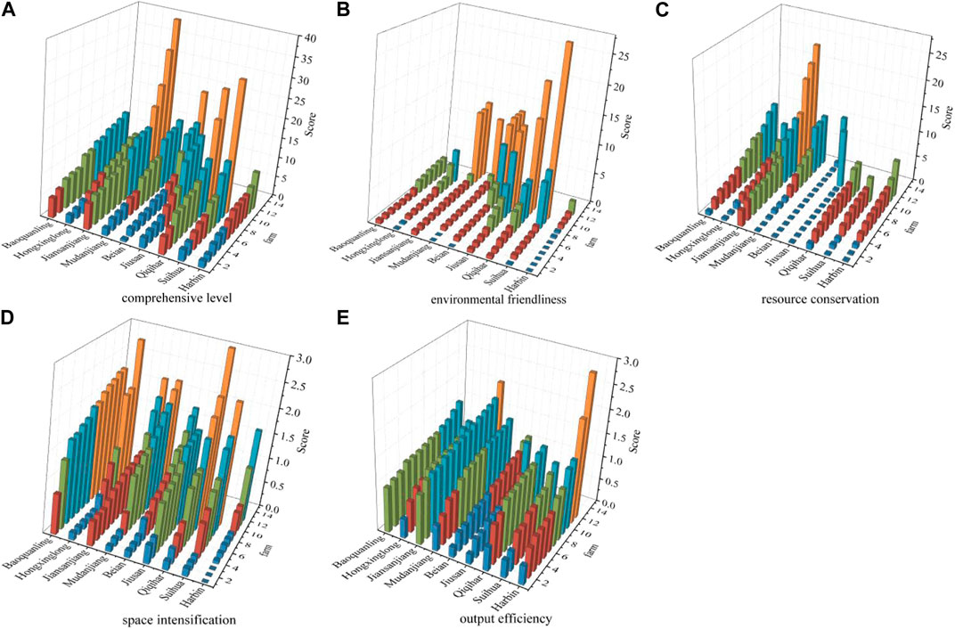
FIGURE 4. GUL-CL in heilongjiang reclamation area.
The overall development of the GUL-CL in the HRA is appreciable. The study results show that 65 farms with a medium or above-cultivated land green use level accounted for 57.522% of the total evaluation units. Among them, 33 farms record higher status or above, accounting for 29.204% t of the total evaluation units. These counties are mainly distributed along the branches of Jiansanjiang and Baoquanling in the northern part of the Sanjiang Plain. In these counties, the protection of cultivated land ecology was appreciable. This achievement may be the backbone of the good results they record in the degree of green land use on cultivated land. Lower-level farms are mainly distributed in branches such as Beian and Harbin. However, there are significant differences in the development of each farm. The extensive GUL-CL ranges from 0.590 to 38.179, with a mean value of 8.818. And 54 farms are above the mean value, accounting for 47.788% of the total amount.
At the environmental friendliness level, there are 21 farms in the higher level zone and above, mainly concentrated in the Songnen Plain Reclamation Area, accounting for 76.19% of the total. However, low-level areas are also focused in the Songnen Plain Reclamation Area, mainly in Harbin Branch. There are ten low-level area farms in total, among which eight low-level area farms in Harbin Branch, accounting for 80%. The Sanjiang Plain Reclamation Area is mainly concentrated in medium and lower-level areas. Contrary to environmental friendliness, the Sanjiang Plain Reclamation Area effectively conserves resources. There are 16 farms in the higher level zone and above, with 87.5% in the Sanjiang Plain Reclamation Area, of which Jiansanjiang is particularly outstanding.
In contrast, the Songnen Plain Reclamation Area is mainly concentrated in lower and below-level areas. At the level of spatial intensification and output efficiency, the overall development of HRA is relatively balanced. In recent years, HRA has been improving the basic conditions of agricultural production, carrying out land improvement projects, transforming low and medium-yielding fields, and building high-standard farmland to form a large-scale and diversified landscape pattern.
The mean value of the coupling degree of the four major systems of GU-CL in HRA is 0.626. These results ranged between 0.600 and 0.800. The strong coupling state indicates that the four significant subsystems of GU-CL in HRA are relatively close. The subsystems have a benign coupling characteristic, mutual checks and balances, and cooperation. Spatially, the coupling degree of each branch varies significantly. Qiqihar (0.759) and Jiansanjiang (0.704) have a high degree of coupling, and the development of the cultivated land green use subsystem is at the same pace. Mudanjiang, Jiusan, and Harbin have a relatively low degree of coupling, and the development of each subsystem is uneven. The coupling degree of cultivated land resource-environment-space-economy is also above 0.610 for the Sanjiang Plain and the Songnen Plain Reclamation Area in the west, which are in a strong coupling stage. The coupling degree in the Sanjiang Plain Reclamation Area is generally higher than in the Songnen Plain Reclamation Area.
The coupling coordination degrees of the four significant subsystems of GU-CL in HRA are concentrated in the distribution of 0.200–0.500. Consequently, the study results show that there are still many gaps for improvement in high coordination. In the same sense, 23 farms had a coupling degree of moderate coordination or higher, accounting for 20.35% of the farms with high coupling coordination. In contrast, the results highlighted 29 farms with coupling degrees in the stage of essential coordination, accounting for 25.66% of the total, with an average level of coupling coordination. In these areas, 53.98% of the farms have a coupling degree between moderate and severe dissonance. The level of coupling coordination in these areas is weak, and these areas need to focus on strengthening support in the future.
The coordination degree of the cultivated land green use subsystem in the HRA is low, which cannot form a synergy for the high-quality development of cultivated land green use and can hardly play the role of mutual promotion. Spatially, although the level of coordination in the Sanjiang Plain is higher than that in the Songnen Plain, it still needs to be strengthened. As a result, improving the coordination of cultivated land resource-environment-spatial-economy is the way forward in HRA for achieving sustainable cultivated land development and green agricultural development. Figure 5.
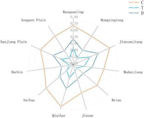
FIGURE 5. Coupling and coordination degree of GU-CL in HRA.
National policies, economic efficiency, social needs, and scientific and technological progress influence the GUL-CL. Chinese President Xi Jinping attaches great importance to and has repeatedly given important instructions, clearly requiring that strong measures must be taken to protect the black land strategically. Relevant central departments have specifically formulated and implemented policy documents such as “Northeast Blackland Conservation Planning Outline (2017–2030) (Ministry of Agriculture, 2017)” and “Northeast Blackland Conservation Farming Action Plan (2020–2025) (Ministry of Agriculture, 2020)”, and local regulations and ordinances have been introduced in Liaoning, Jilin, Heilongjiang and Inner Mongolia. Thus, the study result shows a strong relationship between the GU-CL and policy. HRA focuses on black soil conservation, soil nutrient balance, water-saving irrigation, conservation tillage, soil erosion control, and other measures. GU-CL has entered a new track of full speed and quality.
Accelerating the progress of agricultural science and technology is the key to sustainable agricultural and rural economic development. Precision agricultural technologies (PATs) are technologies aimed at managing in-field heterogeneity (Aubert et al., 2012). As an important commodity grain base and strategic reserve base for grain in China, HRA is striving to develop modernized agriculture as a demonstration area for modernized agriculture. Since 2001, HRA has built a modern agricultural machinery management command and dispatch information system by implementing a pilot project on precision agricultural technologies. Similarly, the project promotes a precision agricultural information system and a GPS navigation wireless mobile network RTK differential system that integrates agricultural machinery information management, command and dispatch, function display, technology training, and management parking. In recent years, the critical technology application of UAV in precision agriculture has achieved good results (Li, 2018). At the same time, due to the development of cultivated land water conservation, soil improvement, and soil conservation technology, the land is concentrated and contiguous through projects such as land remediation and high-standard cultivated land construction. It is more conducive to mechanical operations and improves labor productivity and agricultural production capacity.
Because the different regions differ in topographic and geomorphological characteristics, climatic features, soil types, and crop planting structures, other regions adopt different patterns of green use of cultivated land, which is the subject of ongoing research and has significant regional variability.
In the Northeast of China, the black soil characteristics include black soil, black calcareous soil, white pulp soil, meadow soil, dark brown soil, brown soil, etc., according to the classification of Chinese soil occurrence (Xu et al., 2010). The natural black soil topsoil has high organic matter content, but there are differences in different regions. Different cultivated land conservation measures are adopted for different soil conditions (Han and Li, 2018). This context may be the reason for the differences in the GUL-CL. For example, the black soil layer conservation model in the middle, the thick soil in the central-eastern part of the Songnen, and the meadow soil area in the Sanjiang Plain. Or the black soil layer cultivation model in the erosion area with thin black soil and shallow black soil types such as native light black soil and dark brown loam. The western area of Songnen Plain is a semi-arid region affected by the superposition of water and wind erosion, and soil erosion is severe. The erosion ditch is dense (Yang and Song, 2021). Therefore, a farming technology system with conservation tillage was the core measure that should be adopted.
Qiqihar Branch is in the upper reaches of the Songhua River water system in Heilongjiang Province and attaches importance to the protection of water resources. It establishes fertilization techniques for significant crops and actively promotes organic fertilizers and green pesticides, so these two indicators of the Qiqihar Branch reach the highest value (Zhang et al., 2020). Harbin Branch is the smallest among the nine branches of the HRA, and the farms are relatively scattered. However, the farms are adjacent to cities such as Harbin and Daqing, which have location advantages and agricultural resources. Even though the amount of land that can be cultivated is limited, the efficiency of production per unit of Climate change can alter the regional water cycle and environment to some extent, affecting crop farming systems, cultivated land productivity, and land use types and patterns, which in turn cause changes in the spatial and temporal patterns of cultivated land (Piao et al., 2010; Chen et al., 2012; Newman et al., 2014). Climate warming has contributed to increased cultivated land in northern China, where the temperature is the limiting factor. Climate warming has already driven the boundary of rice cultivation in Heilongjiang Province from 48°N to 52°N to the North, resulting in a gradual increase in the area under rice cultivation (Piao et al., 2010)—a significant expansion of rice cultivation in the Heilongjiang Reclamation Area (Figure 6).

FIGURE 6. 2000–2020a Distribution of paddy and dryland in HRA.
Not only that, during the past 40 years, 80% of the expanded area under rice cultivation was distributed in the Eastern part of the Songnen Plain and the Sanjiang Plain areas, with annual precipitation of less than 500 mm. Moreover, the Songnen Plain has also experienced significant growth in rice cultivation in regions with an annual rainfall of less than 350 mm, with a 22% growth area share (Li et al., 2021). However, the spatial and temporal response of rice area migration characteristics in Northeast China to regional precipitation changes is not closely related (Chen et al., 2016). Such as Jiusan, Harbin, and other branches with low precipitation also carry out “dry to water” projects. In addition, the black soil area soybean plantings will undergo re-expansion in the current “double cycle” new development pattern requirements. Beian, Jiusan, Qiqihar, and other branches are making suitable adjustments to their planting structures by reducing corn and increasing soybeans. However, soybean is a highly water-consuming crop and needs to be supported by corresponding irrigation water resources if higher yield levels are maintained.
In contrast, in 2015, Jiansanjiang started building surface water irrigation projects and took scientific and reasonable steps, like rotating fallow crops and reducing groundwater extraction, which put it at the highest level of water-saving irrigation and surface water replacement groundwater. There are differences in water resource use and other and other aspects among the authorities due to differences in the structure of cultivation (Cui et al., 2020). Subsequent studies on the green use of cultivated land will provide an in-depth discussion of how different cropping structures adopt land conservation.
With the strategy of “hiding grain in the land and hiding grain in technology,” the GU-CL is an inevitable trend. In other words, it is a realistic choice for black soil protection. A specific regional model has been implemented and formed in HRA, which can provide some reference value for other regions, predominantly rural areas. At the same time, based on the results and analysis, the following suggestions are made.
(1) Develop a differentiated development strategy for the GU-CL based on the reclamation area’s economic structure and resource endowment. Sanjiang Plain Reclamation Area needs to be strengthened at an environmental friendliness level. They should accelerate the transformation of farmers’ production concepts and promote new plant protection. Then, this strategy will focus on soil testing, formula fertilization, and other agricultural technologies. Reducing the intensity of fertilizer, pesticide, and agricultural film application, promoting agriculture, improving agricultural production quality, and alleviating agricultural surface source pollution are among the strategies they must implement. Songnen Plain Reclamation Area needs to improve energy use efficiency, reduce the intensity of agricultural electricity use, increase agricultural water conservation techniques, and adjust the crop planting structure at the right time.
(2) Strengthen inter-regional synergy, and promote the coupled and coordinated development of cultivated land use. HRA has achieved output efficiency, but environmental friendliness and resource conservation are crucial to promoting GU-CL. Harbin Branch plays a leading role in strengthening the radiation effect of green production technology. Jiansanjiang and Qiqihar Branch, as critical agricultural production areas, promote comprehensive ecological management and take the road of intensive and economic development, which is conducive to the coupling between agricultural development and the environmental environment.
(3) Ecological compensation, as an effective environmental incentive policy, is essential in improving the ecology concern worldwide (Jiang et al., 2022). The government needs to increase financial support for developing and applying new pollution prevention and control technology. Promote land remediation projects to realize a virtuous cycle of ecological management and land resource development. Increase ecological compensation for cultivated land and state transfer payments to make cultivated land in reclamation areas safer for the environment.
Given the authors’ research level and data availability, this paper has a few shortcomings. First, the selection of indicators may not be comprehensive enough. Cultivated land utilization is a long-term and complex process involving various aspects. The indicator of cultivated land or system may not fully reflect the connotation of green utilization of cultivated land. Secondly, the one-year data cannot fully reflect the transformation process of green use of cultivated land in the reclamation area, which is not in-depth and comprehensive. In the next step, a more in-depth study can be conducted using consecutive multi-year data to obtain more practical results.
In evaluating the single element of GUL-CL, there are obvious differences between different indicators of GUL-CL in the same region, which have certain advantages and disadvantages. The high-level area of GUL-CL is mainly distributed in branches such as Jiansanjiang and Baoquanling in the northern part of the Sanjiang Plain. The low-value area is primarily distributed in branches such as Beian and Harbin. This context leads to significant differences within farms due to the various measures other farms take for the GU-CL and the varying degrees of implementation.
The high-level areas in terms of environmental friendliness are primarily concentrated in the Songnen Plain Reclamation Area. In contrast, at the level of resource conservation, the effect is significant in the Sanjiang plain Reclamation Area, with Jiansanjiang performing exceptionally well. At the level of spatial intensification and output efficiency, the overall development of the HRA is relatively balanced. Land remediation and high-standard farmland construction projects promote the increase of grain production and enhance agricultural production capacity.
Overarchingly, the coupling degree of GU-CL ranges from 0.600 to 0.800, which is a moderately strong coupling. Qiqihar branch is one area in which the GU-CL was significant; therefore, the green utilization system of cultivated land is in a state of mutual feedback, balance, and development. In contrast, the degree of coupling and coordination of GU-CL ranges between 0.200 and 0.500, considered low, and Hongxinglong as an example. Accordingly, the cultivated land green system presented a synergistic resonance development. GU-CL in HRA has ample space for improvement and excellent development potential.
The original contributions presented in the study are included in the article/Supplementary Material, further inquiries can be directed to the corresponding author.
Ethical review and approval were not required for the study on human participants following the local legislation and institutional requirements.
GD and JX: substantial contributions to conception and design, data acquisition, analysis, and interpretation; GD and JX: drafting the article and revising it critically for important intellectual content; JX: collecting the data. GD, DH, and FY: writing—review and editing. All authors have read and agreed to the published version of the manuscript.
This research was funded by the National Key R&D Program of China, grant No. 2021YFD1500101.
The authors declare that the research was conducted in the absence of any commercial or financial relationships that could be construed as a potential conflict of interest.
All claims expressed in this article are solely those of the authors and do not necessarily represent those of their affiliated organizations, or those of the publisher, the editors and the reviewers. Any product that may be evaluated in this article, or claim that may be made by its manufacturer, is not guaranteed or endorsed by the publisher.
Aubert, B. A., Schroeder, A., and Grimaudo, J. (2012). IT as enabler of sustainable farming: An empirical analysis of farmers’ adoption decision of precision agriculture technology. Decis. Support Syst. 54, 510–520. doi:10.1016/j.dss.2012.07.002
Bryan, B. A., Gao, L., Ye, Y., Sun, X., Connor, J. D., Crossman, N. D., et al. (2018). China’s response to a national land-system sustainability emergency. Nature 559, 193–204. doi:10.1038/s41586-018-0280-2
Chai, C., Zhang, B., Li, Y., Niu, W., Zheng, W., Kong, X., et al. (2023). A new multi-dimensional framework considering environmental impacts to assess green development level of cultivated land during 1990 to 2018 in China. Environ. Impact Assess. Rev. 98, 106927. doi:10.1016/j.eiar.2022.106927
Chen, C., Qian, C., Deng, A., and Zhang, W. (2012). Progressive and active adaptations of cropping system to climate change in Northeast China. Eur. J. Agron. 38, 94–103. doi:10.1016/j.eja.2011.07.003
Chen, H., Li, Z. G., Tang, P. Q., Hu, Y. N., Tan, J. Y., Liu, Z. H., et al. (2016). Spatial and temporal distribution characteristics of rice in Northeast China in the context of climate change. J. Appl. Ecol. 27, 2571–2579. doi:10.13287/j.1001-9332.201608.036
Chen, L., Zhao, H., Song, G., and Liu, Y. (2021). Optimization of cultivated land pattern for achieving cultivated land system security: A case study in Heilongjiang Province, China. Land Use Policy 108, 105589. doi:10.1016/j.landusepol.2021.105589
Cui, N., Yu, Z., and Jiang, X. (2020). Study on water use efficiency of grain production in Heilongjiang Reclamation Area. Agricultural Economics and Management 05, 54–63. Available at: http://h-s.kns.cnki.net.neau.vpn358.com/kcms/detail/detail.aspx?dbcode=CJFD&dbname=CJFDLAST2020&filename=NYJG202005005&uniplatform=NZKPT&v=1pZoxY1QKduZlR7AlsmLiISl066SmUJQOlVqPVZ6-cuJl2PEQf0fyA7WXMo88j9y.
Dong, L., Shang, J., Ali, R., and Rehman, R. U. (2021). The coupling coordinated relationship between new-type urbanization, eco-environment and its driving mechanism: A case of guanzhong, China. Front. Environ. Sci. 9, 638891. doi:10.3389/fenvs.2021.638891
Du, G., Guo, K., and Yu, F. R. (2021). Transformation of arable land use function in the Heilongjiang Reclamation Area and suggestions for regulation. Agric. Mod. Res. 42, 589–599. doi:10.13872/j.1000-0275.2021.0080
German, R. N., Thompson, C. E., and Benton, T. G. (2017). ‘Relationships among multiple aspects of agriculture’s environmental impact and productivity: A meta-analysis to guide sustainable agriculture. Biol. Rev. 92, 716–738. doi:10.1111/brv.12251
Han, X. Z., and Li, N. (2018). Progress and prospects of blackland research in northeastern China. Geoscience 38, 1032–1041. doi:10.13249/j.cnki.sgs.2018.07.004
Harper, J. K., Roth, G. W., Garalejić, B., and Škrbić, N. (2018). Programs to promote adoption of conservation tillage: A Serbian case study. Land Use Policy 78, 295–302. doi:10.1016/j.landusepol.2018.06.028
Jiang, Y., Guan, D., He, X., Yin, B., Zhou, L., Sun, L., et al. (2022). Quantification of the coupling relationship between ecological compensation and ecosystem services in the Yangtze River Economic Belt, China. Land Use Policy 114, 105995. doi:10.1016/j.landusepol.2022.105995
Ke, S., Cui, H., Lu, X., Hou, J., and Wu, Y. (2021). Study on the spatial and temporal patterns of green transformation of arable land use and its driving mechanism: The case of hubei Province. China Land Sci. 35, 64–74.
Kuang, B., Lu, X., Zhou, M., and Chen, D. (2020). Provincial cultivated land use efficiency in China: Empirical analysis based on the SBM-DEA model with carbon emissions considered. Technol. Forecast. Soc. Change 151, 119874. doi:10.1016/j.techfore.2019.119874
Lai, Z., Chen, M., and Liu, T. (2020). Changes in and prospects for cultivated land use since the reform and opening up in China. Land Use Policy 97, 104781. doi:10.1016/j.landusepol.2020.104781
Li, B., Liu, Z., Huang, F., Yang, X., Liu, Z., Wan, W., et al. (2021). Consolidating the black land granary to ensure national food security. Proc. Chin. Acad. Sci. 36, 1184–1193. doi:10.16418/j.issn.1000-3045.20210706003
Li, D. (2018). Analysis of the development of precision agriculture in Heilongjiang reclamation area. Modern Agriculture 06, 63–64. Available at: http://h-s.kns.cnki.net.neau.vpn358.com/kcms/detail/detail.aspx?dbcode=CJFD&dbname=CJFDLAST2018&filename=XDHY201806037&uniplatform=NZKPT&v=ppe-GDi_o2TAQAruDgRLRb1K40JoLBN_d-yH7S588u9IZCXH4f0fIAVXZ1-vWvrg.
Li, Q., and Liu, G. (2021). Is land nationalization more conducive to sustainable development of cultivated land and food security than land privatization in post-socialist central asia? Glob. Food secur. 30, 100560. doi:10.1016/j.gfs.2021.100560
Li, X., Wu, K., Yang, Q., Hao, S., Feng, Z., and Ma, J. (2023). Quantitative assessment of cultivated land use intensity in Heilongjiang Province, China, 2001–2015. Land Use Policy 125, 106505. doi:10.1016/j.landusepol.2022.106505
Liu, X. B., Zhang, X. Y., Wang, Y. X., Sui, Y. Y., Zhang, S. L., Herbert, S. J., et al. (2010). Soil degradation: A problem threatening the sustainable development of agriculture in Northeast China. Plant Soil Environ. 56, 87–97. doi:10.17221/155/2009-PSE
Lu, X., Qu, Y., Sun, P., Yu, W., and Peng, W. (2020). Green transition of cultivated land use in the yellow river basin: A perspective of green utilization efficiency evaluation. Land 9, 475. doi:10.3390/land9120475
Ma, L., Long, H., Tu, S., Zhang, Y., and Zheng, Y. (2020). Farmland transition in China and its policy implications. Land Use Policy 92, 104470. doi:10.1016/j.landusepol.2020.104470
Ministry of Agriculture (2020). Ministry of agriculture and rural affairs ministry of finance notice on the issuance of the action plan for conservation farming in Northeast China (2020-2025). Communiqué of the Ministry of Agriculture and Rural Affairs of the People's Republic of China 04, 9–11. Available at: http://h-s.kns.cnki.net.neau.vpn358.com/kcms/detail/detail.aspx?dbcode=CJFD&dbname=CJFDLASN2020&filename=GNZB202004002&uniplatform=NZKPT&v=G4c9SPoydd1sT25y5yX_yPuCZof9G6CGBks7UiFN8UvYVTLB8SN1_4USuB9j1Ki6.
Ministry of Agriculture (2017). National development and reform commission, ministry of finance, ministry of land and resources, ministry of environmental protection, ministry of water resources on the issuance of the Northeast Blackland conservation plan outline (2017-2030). Bulletin of the Ministry of Agriculture of the People's Republic of China 07, 50–54. Available at: http://h-s.kns.cnki.net.neau.vpn358.com/kcms/detail/detail.aspx?dbcode=CJFD&dbname=CJFDLASN2017&filename=GNZB201707018&uniplatform=NZKPT&v=h8GAR5hlmQKZkeAiJ_lYNfrvuvCZqpmdADjih_51yuzrD7jl1oarx4dCv3V01XSG.
Newman, M. E., McLaren, K. P., and Wilson, B. S. (2014). Long-term socio-economic and spatial pattern drivers of land cover change in a Caribbean tropical moist forest, the Cockpit Country, Jamaica. Jam. Agric. Ecosyst. Environ. 186, 185–200. doi:10.1016/j.agee.2014.01.030
Ning, J., Liu, J., Kuang, W., Xu, X., Zhang, S., Yan, C., et al. (2018). Spatiotemporal patterns and characteristics of land-use change in China during 2010–2015. J. Geogr. Sci. 28, 547–562. doi:10.1007/s11442-018-1490-0
Peltonen-Sainio, P., Jauhiainen, L., Laurila, H., Sorvali, J., Honkavaara, E., Wittke, S., et al. (2019). Land use optimization tool for sustainable intensification of high-latitude agricultural systems. Land Use Policy 88, 104104. doi:10.1016/j.landusepol.2019.104104
Piao, S., Ciais, P., Huang, Y., Shen, Z., Peng, S., Li, J., et al. (2010). The impacts of climate change on water resources and agriculture in China. Nature 467, 43–51. doi:10.1038/nature09364
Rinot, O., Levy, G. J., Steinberger, Y., Svoray, T., and Eshel, G. (2019). Soil health assessment: A critical review of current methodologies and a proposed new approach. Sci. Total Environ. 648, 1484–1491. doi:10.1016/j.scitotenv.2018.08.259
Song, W., Zhang, H., Zhao, R., Wu, K., Li, X., Niu, B., et al. (2022). Study on cultivated land quality evaluation from the perspective of farmland ecosystems. Ecol. Indic. 139, 108959. doi:10.1016/j.ecolind.2022.108959
Wang, T., Xu, X., Wang, C., Li, Z., and Li, D. (2021). From smart farming towards unmanned farms: A new mode of agricultural production. Agriculture 11, 145. doi:10.3390/agriculture11020145
Wei, Y., Gan, Z., Cheng, J., and Zhang, H. (2021). On the green use of land. China Land Sci. 35, 27–34.
Xie, H., and Liu, G. (2015). Spatiotemporal differences and influencing factors of multiple cropping index in China during 1998–2012. J. Geogr. Sci. 25, 1283–1297. doi:10.1007/s11442-015-1234-3
Xu, S. (2019). Temporal and spatial characteristics of the change of cultivated land resources in the black soil region of Heilongjiang Province (China). Sustainability 11, 38. doi:10.3390/su11010038
Xu, W., Zhang, X., Xu, Q., Gong, H., Li, Q., Liu, B., et al. (2020). Study on the coupling coordination relationship between water-use efficiency and economic development. Sustainability 12, 1246. doi:10.3390/su12031246
Xu, X. Z., Xu, Y., Chen, S. C., Xu, S. G., and Zhang, H. W. (2010). Soil loss and conservation in the black soil region of Northeast China: A retrospective study. Environ. Sci. Policy 13, 793–800. doi:10.1016/j.envsci.2010.07.004
Yang, Y., Bao, W., and Liu, Y. (2020). Coupling coordination analysis of rural production-living-ecological space in the Beijing-Tianjin-Hebei region. Ecol. Indic. 117, 106512. doi:10.1016/j.ecolind.2020.106512
Yang, Y., and Song, G. (2021). Human disturbance changes based on spatiotemporal heterogeneity of regional ecological vulnerability: A case study of qiqihaer city, northwestern Songnen Plain, China. J. Clean. Prod. 291, 125262. doi:10.1016/j.jclepro.2020.125262
Ye, S., Ren, S., Song, C., Cheng, C., Shen, S., Yang, J., et al. (2022). Spatial patterns of county-level arable land productive-capacity and its coordination with land-use intensity in mainland China. Agric. Ecosyst. Environ. 326, 107757. doi:10.1016/j.agee.2021.107757
Ye, S., Song, C., Shen, S., Gao, P., Cheng, C., Cheng, F., et al. (2020). Spatial pattern of arable land-use intensity in China. Land Use Policy 99, 104845. doi:10.1016/j.landusepol.2020.104845
Yu, C., Huang, X., Chen, H., Godfray, H. C. J., Wright, J. S., Hall, J. W., et al. (2019). Managing nitrogen to restore water quality in China. Nature 567, 516–520. doi:10.1038/s41586-019-1001-1
Yu, Y. Q., Wang, C. S., Peng, L. L. L., and Yu, Y. F. (2022). Evaluation of green development level of agriculture and analysis of obstacles based on entropy weight TOPSIS model--Jiangxi Province as an example. China Agric. Resour. Zoning 43, 187–196.
Yue, Q., Guo, P., Wu, H., Wang, Y., and Zhang, C. (2022). Towards sustainable circular agriculture: An integrated optimization framework for crop-livestock-biogas-crop recycling system management under uncertainty. Agric. Syst. 196, 103347. doi:10.1016/j.agsy.2021.103347
Zambon, I., Colantoni, A., Carlucci, M., Morrow, N., Sateriano, A., and Salvati, L. (2017). Land quality, sustainable development and environmental degradation in agricultural districts: A computational approach based on entropy indexes. Environ. Impact Assess. Rev. 64, 37–46. doi:10.1016/j.eiar.2017.01.003
Zhang, B., Li, X., Chen, H., Niu, W., Kong, X., Yu, Q., et al. (2022). Identifying opportunities to close yield gaps in China by use of certificated cultivars to estimate potential productivity. Land Use Policy 117, 106080. doi:10.1016/j.landusepol.2022.106080
Zhang, H., Gao, S., and Lv, Y. (2020). Exploration of a new way to prevent soil erosion by implementing integrated utilization of straw in black soil area in Jiusan Administration of Heilongjiang Province. Farm Economic Management 03, 18–19. Available at: http://h-s.kns.cnki.net.neau.vpn358.com/kcms/detail/detail.aspx?dbcode=CJFD&dbname=CJFDLAST2020&filename=NCJG202003006&uniplatform=NZKPT&v=gwbDXirL7w97NcICOHeLBPZmY6VZOyOQQ7j0VuRlbG-zY2uz4JkCRnMYDqfxjeBn.
Zhou, Y., Li, X., and Liu, Y. (2021). Cultivated land protection and rational use in China. Land Use Policy 106, 105454. doi:10.1016/j.landusepol.2021.105454
Keywords: cultivated land use, the green use level of cultivated land, regional differences, black-soil areas, heilongjiang reclamation area
Citation: Du G, Xie J, Hou D and Yu F (2023) Regional differences in the green use level of cultivated land in the Heilongjiang reclamation area. Front. Environ. Sci. 11:1134271. doi: 10.3389/fenvs.2023.1134271
Received: 30 December 2022; Accepted: 20 March 2023;
Published: 29 March 2023.
Edited by:
Xiangbin Kong, China Agricultural University, ChinaReviewed by:
Weijing Ma, Lanzhou University, ChinaCopyright © 2023 Du, Xie, Hou and Yu. This is an open-access article distributed under the terms of the Creative Commons Attribution License (CC BY). The use, distribution or reproduction in other forums is permitted, provided the original author(s) and the copyright owner(s) are credited and that the original publication in this journal is cited, in accordance with accepted academic practice. No use, distribution or reproduction is permitted which does not comply with these terms.
*Correspondence: Guoming Du, ZHVndW9taW5nQG5lYXUuZWR1LmNu
Disclaimer: All claims expressed in this article are solely those of the authors and do not necessarily represent those of their affiliated organizations, or those of the publisher, the editors and the reviewers. Any product that may be evaluated in this article or claim that may be made by its manufacturer is not guaranteed or endorsed by the publisher.
Research integrity at Frontiers
Learn more about the work of our research integrity team to safeguard the quality of each article we publish.