 Alline Dias
 Rafael Robina-Ramírez
 Marcelo Sánchez-Oro Sánchez2
95% of researchers rate our articles as excellent or good
Learn more about the work of our research integrity team to safeguard the quality of each article we publish.
Find out more
ORIGINAL RESEARCH article
Front. Environ. Sci. , 20 April 2023
Sec. Environmental Economics and Management
Volume 11 - 2023 | https://doi.org/10.3389/fenvs.2023.1132162
This article is part of the Research Topic Resources and Environmental Management for Green Development View all 26 articles
Introduction: The holistic concept of the sustainable development of United Nations Educational, Scientific and Cultural Organization (UNESCO) Global Geoparks encompasses the promotion of connected protected areas and activities that link geological heritage with other aspects of natural and cultural heritage. This case study aims to identify points of articulation and/or to identify conflicts in the overlap between protected areas and UNESCO World Geoparks in Portugal, and to provide information to improve the interrelation of these designations.
Methods: The methodological procedures in analysing the organisational structures of different classified areas from the respective management documents. The technical procedure consisted of document consultation and on-site activities carried out between September 2020 and November 2021.
Results: The study resulted in the identification of points of natural objects that can be held together by protected natural spaces and aspiring Oeste Geopark. A proposal for synergistic action was presented, with the main pillars of integration in the territory. The different designations for sustainable territorial management in complementary to the conservation of natural heritage. The results of the analyses indicate that the overlap of the different designations of areas and territories studied here can act both in a joint and complementary way to conserve natural heritage.
Discussion: This reinforcement study, which has different designations of areas and/or territories for sustainable territorial planning at the local, regional, national, and international levels, is fundamental for nature conservation, lacking more in terms of efficient management and integration of the social component.
Territorial management is the challenge of a complex conservation of themes to reconcile the environment, which depends on environmental resources and environmental advances that are established in a territory, where they occur as diverse, close, and social developments as well as in disputes of the policies involved (Dong et al., 2021; Henrique and Toniolo, 2021; Li et al., 2022). The discussion has problems related to factors such as difficulty in socio-environmental processes and lack of development or interdisciplinarity, such as the involvement of society and nature (Li et al., 2022).
Thus, territorial planning must priorities a holistic approach (Duval and Benedetti, 2019) arising from territorial governance policies focused on environmental citizenship, going beyond sectorial ones (Sengur and Nurlu, 2021; Chaves and Barros, 2022). Governance with trans disciplinary and cross-sectoral actions is one of the mechanisms of increasing applicability ordered by the pillars of sustainability (Sengur and Nurlu, 2021; Chaves and Barros, 2022).
It is a biophysics strategy in which the biophysical and socioeconomic conditions and design needs of communities are present as solutions for development, as one must consider the traditional and ecological aspects committed to the sites (Altieri, 1995), surpassing only technological solutions devoid of culture and historical contexts (Pérez Rubio, 2007; Santos, 2015).
In this way, territorial planning and management are sustainable, develop a systemic approach, and are studied on an ecosystem basis (Castanho, 2017; Duval and Benedetti, 2019; Giraldo-Ospina and Zumbado-Morales, 2020). In this sense, protected areas and UNESCO Global Geoparks operate as tools to support territorial management (Canton, 2007; Sánchez Cortez, 2011; Pásková and Zelenka, 2018; Dong et al., 2021) as components that can participate in collaborative dialogue and strengthen their capacity to fulfill their role in the conservation of natural heritage.
As protected, both nationally and internationally, a relevant mechanism for the preservation and conservation of natural environments has been implemented for more than a century and half (Mora, 2009; Pellizzaro et al., 2015). Each country has a specific legislation for adjusting this mechanism and defining categories of protected areas (Pellizzaro et al., 2015). These are in line with international concepts, such as the “Washington Declaration” of 1940 and the International Union for Conservation of Nature (IUCN) concept, which was updated in 2008 (Mora, 2009).
The instruments for defining these areas, the Creation Law, and the Management Plan present rules and means for their use. Local creation and management are responsible for preserving the planet’s biodiversity in the face of environmental degradation (Dudley, 2008; Pellizzaro et al., 2015).
Geoparks are attributed to the Global Geopark Network under the auspices of UNESCO to an area where geological heritage sites represent a part of the holistic concept of protection, education, and sustainable development (Medeiros et al., 2015; United Nations Organization for Education, Science and Culture [UNESCO], 2015). This brand was created in 2015, after almost two decades of the emergence of the Geopark concept (Pásková and Zelenka, 2018). Cooperation with the local population, one of the pillars of Geopark management, proves to be an effective strategy for the conservation of these sites (Henriques and Brilha, 2017), building a bottom-up process involving authorities, communities and private investors, as well as educational and research institutions (Farsani et al., 2010; UNESCO, 2010). The holistic concept of the sustainable development of UNESCO Global Geoparks encompasses the promotion of protected areas and activities that connect geological heritage with other aspects of natural and cultural heritage (UNESCO, 2015). It also emphasizes the need for a conservation model that encompasses the entire geographic and social environment, in addition to sites of biological interest (Sánchez Cortez et al., 2013). This is similar to other actors on a national and global scale (Melo Filho, 2021).
Of the 44 countries with geoparks, only 11 have 5 or more global geoparks. Portugal is among these countries (Setién, 2021). With 5 global geoparks and 3 aspiring projects Portugal has its relevance in terms of quantity and in relation to quantity per surface of the country. Since 2006, this country has been part of the UNESCO World Geoparks Network, providing experiences related to the involvement of local communities in the preservation of the natural heritage (Henriques and Tomaz C, 2012; Rodrigues et al., 2021).
The territory of the Oeste Geopark, aspiring to be the UNESCO World Geopark, is in the center-west region of Portugal (Figure 1), encompassing six municipalities, Bombarral, Cadaval, Caldas da Rainha, Lourinhã, Peniche, and Torres Vedras, with 212,103 inhabitants (Associação Geoparque Oeste [AGEO], 2021). It has a total area of 1,154 km2, with 72 km of Atlantic coast where there are rocks with ages from the end of the Triassic to the Quaternary, mostly from the Jurassic (77%), Lower Cretaceous (13%), and other ages (10%) (Associação Geoparque Oeste, 2021).
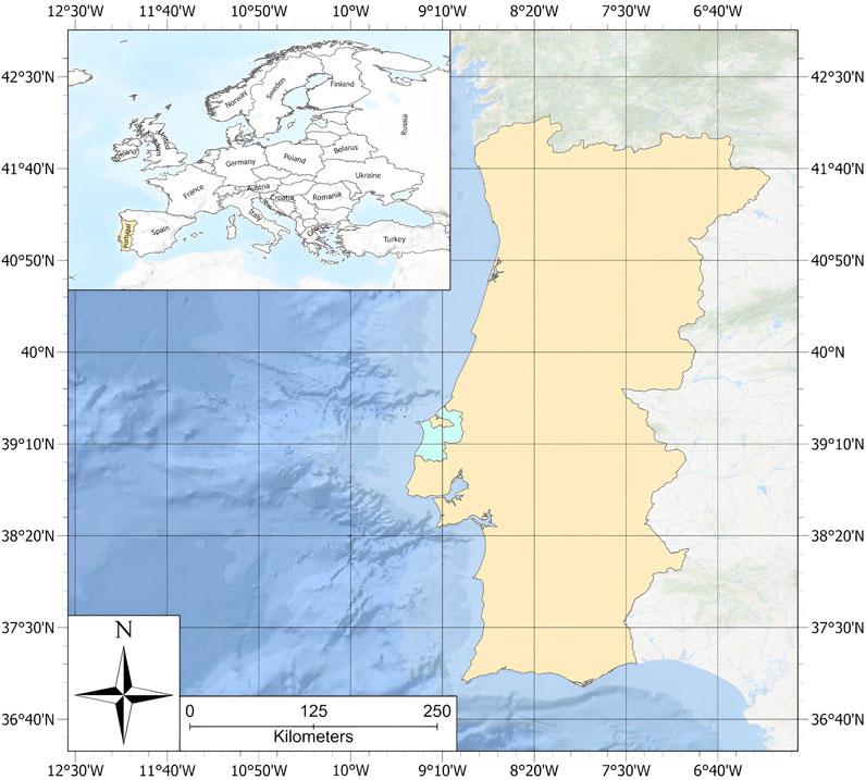
FIGURE 1. Location of the aspiring Oeste Geopark. Source: file made available by the aspiring Oeste Geopark team (2021).
The candidacy of this territory is justified by its diversified and historically relevant cultural heritage (material and immaterial) and the care of its natural heritage (Associação Geoparque Oeste, 2021). Historic site geodiversity is at the moment, of the record of a long history, portraying the gradual evolution of the Atlantic with 180 fossil fossils (vertebrates and invertebrates) inventoried until more than seven geosites were identified and characterised: a Global Boundary Stratotype Section and Ponto (GSSP of the Toarcian floor–Lower Jurassic), and extensive scientific publication on the geology of the region (Associação Geoparque Oeste, 2021).
Regarding biodiversity, the territory of the aGO is in the Mediterranean and Atlantic biogeographic regions, having distinct marine and comprehensive terrestrial ecosystems that extend from the Coastal Zone of the Western Region, passing through plateaus and wetlands to mountain range formations in the interior of the continent, comprising repositories of natural vegetation which are of national and international importance (Loureiro et al., 2007; Ferreira, 2013; Institute for the Conservation of Nature and Forests, 2020a).
The management accounts for local public entities and the integrated organizational partners of private entities, and local associations, at national and international levels. In this way, it carries out networking with the aim of encouraging the development of the region in accordance with the principles of protection and enhancement of natural and cultural heritage, research, and sustainable development (Associação Geoparque Oeste, 2021).
The UNESCO Global Geopark aspiring project overlaps with other internationally designated (the Biosphere Reserve and Ramsar Site) and protected areas instituted by legal mechanisms at the national level. Of the seventy geosite spaces identified so far, 34 were in these protected spaces. With this configuration, aGO faces with the task of establishing partnerships with these areas, examining complementarity, building an independent brand, and publicizing them as protected areas (UNESCO, 2022).
This scenario evokes a comprehensive understanding of the importance of a conservation model for the synergy between geo diversity, biodiversity, culture, and tangible and intangible manifestations (Sánchez Cortez et al., 2013). Understanding the complexity of a territory with overlapping limits guides a more synchronized management that contributes to the fulfillment of conservation objectives (França and Martins, 2020).
This study addresses the issue of interaction between different designations of areas/territories that aim at sustainable territorial development. The research was developed at the institutional level with a document analysis based on the planning stage of activities with the local community and visitors.
The objectives of this study were to identify points of joint action and/or to identify conflicts in the overlap between protected areas and UNESCO World Geoparks in Portugal, and to improve the interrelation of these designations. In this study, the case of the aspiring Geoparque Oeste (aGO) and the protected areas included in this territory were chosen. It was considered because it is a project in the planning and preparation phase of the UNESCO World Geopark candidacy, which involves strategic collaboration with already established protected natural areas and those in the process of implementation. Furthermore, these areas represent different categories at national (local and regional), European and international levels.
In the territory of the aspirant Oeste Geopark, seven protected natural spaces are located, as shown in Figure 2.
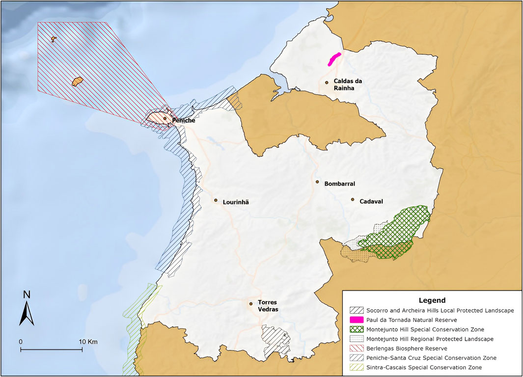
FIGURE 2. Protected natural spaces in the territory of the aspiring Oeste Geopark. Source: file made available by the aspiring Oeste Geopark team (2021).
The areas are marked by the National System of Classified Areas (SNAC) built by Decree-Law No. 142/2008 on 24 July (State of the environment report, 2021). Table 1 provides a description of these locations.
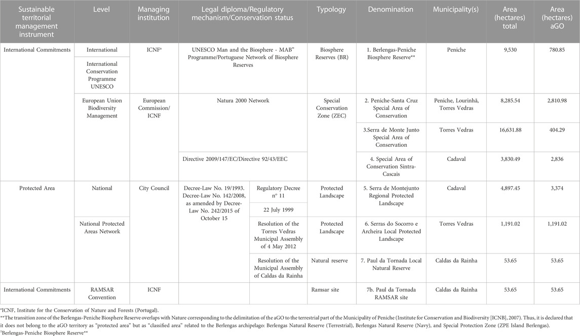
TABLE 1. Areas designated for sustainable territorial management according to Portugal’s national system of classified areas (nuclear areas) within the aGO territory. Source: Own elaboration.
A pioneer in the preservation of biodiversity, the Man and the Biosphere Program (MAB) was created 50 years ago (UNESCO, 2021). According to the ICNF Biosphere Reserve, this is a territory, where there is a mosaic of important and representative ecosystems of a given Biogeographic Region, whose purpose is to combine the conservation of natural values with the maintenance of cultural values and the sustainable socio-economic development of the population living in it.
The Biosphere Reserves integrate terrestrial, marine and coastal ecosystems. These are territories where interdisciplinary approaches are tested to understand and manage the changes and interactions of social and ecological systems, in particular conflict prevention and biodiversity management. Each Biosphere Reserve promotes the solutions appropriate to its reality with a view to reconciling the conservation of biodiversity with its sustainable use. They are places that provide local solutions to global challenges. The territories classified with this designation remain under the sovereign jurisdiction of the Member States where they are located. Its status is internationally recognized (UNESCO, 2021).
As a pilot area or sustainability laboratory, where innovation and knowledge transfer are promoted, Biosphere Reserves must necessarily promote 3 functions: 1) The conservation of species, ecosystems and landscapes; 2) Social, cultural and ecologically sustainable development; and 3) Research, monitoring, dissemination and environmental awareness (UNESCO, 2021).
As for zoning, they must present three types of interrelated areas that fulfill complementary functions and reinforce each other: core zone - one or more strictly protected areas dedicated to nature conservation, research and monitoring of less altered ecosystems; buffer zone - where the effects of human actions on the nuclear area are cushioned and where less impacting human activities are carried out, such as environmental education, recreation and leisure, nature tourism or applied research. It involves the nuclear zone; transition zone - a sufficiently large area where economic activities are developed and there are large population centers. It involves the buffer zone (UNESCO, 2021).
The Berlengas-Peniche Biosphere Reserve (Figure 3) was created in 2011 and covers an area of the current Berlengas Natural Reserve, Peniche Peninsula, and maritime corridor. Its management documents are the Management Plan for the Municipality of Peniche and the Management Plan for the Berlengas Nature Reserve, being managed by the ICNF (ICNB, 2007). Five geosites of aGO are located in the transition zone.

FIGURE 3. Berlengas-Peniche biosphere reserve. Source: produced by the authors.
The Ramsar Convention is a global treaty that focuses specifically on wetlands. The Convention on Wetlands is an intergovernmental treaty that provides the framework for national action and international cooperation for the conservation and wise use of wetlands and their resources (Ramsar Site, 2021).
The Ramsar Site nº. 1106 (Figure 4), called Paul de Tornada, superimposed on Paul da Tornada Local Natural Reserve, is located in the Municipality of Caldas da Rainha (Ramsar Site, 2021). Management at the international level takes place through the Strategic Plan for 2016—2024 (Ramsar Site, 2021). This is located at Geosite 1.
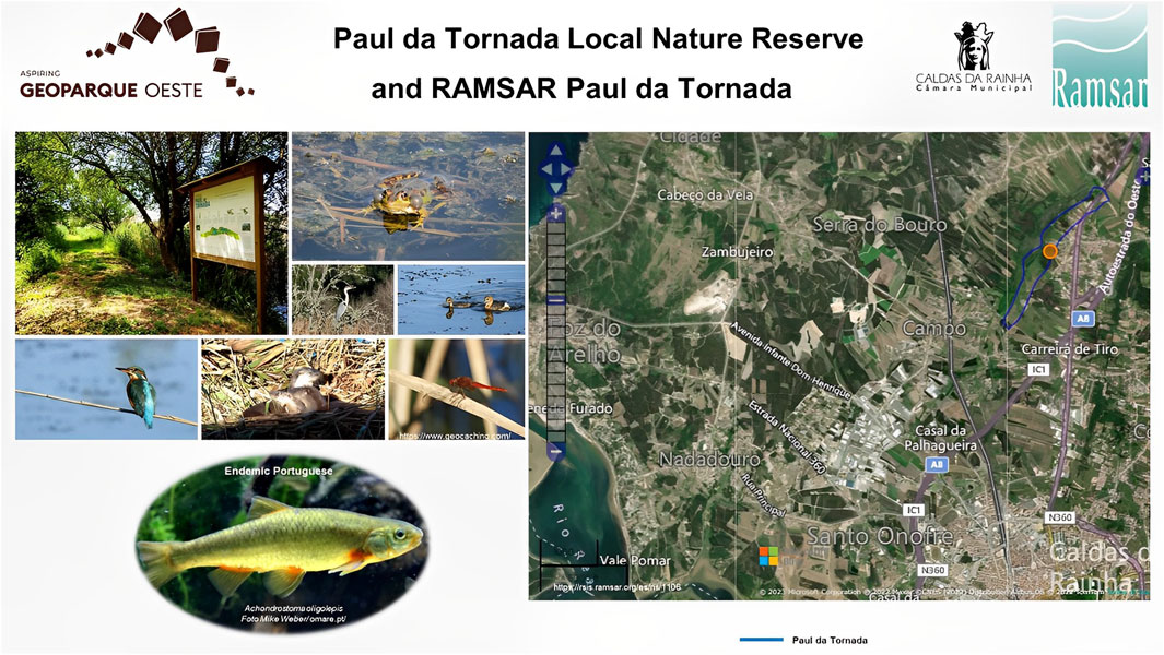
FIGURE 4. Ramsar Paul da Tornada site. Source: produced by the authors.
Created under the Habitats Directive, with the express objective of “contributing to ensure Biodiversity, through the conservation of natural habitats and habitats of species of wild flora and fauna, considered threatened in the European Union.” In these areas of community importance for the conservation of certain habitats and species, human activities must be compatible with the preservation of these values, aiming at sustainable management from an ecological, economic and social point of view.
Created in 2006, it extends along the coast as a strip of variable width (between 50 and 2,500 m) (Figure 5). The management documents are the Management Plan and Sectorial Plan of the Natura 2000 Network. The ICNF is the national management body here (ICNF b, 2020). There are 25 aGO geosites appearing in this zone.
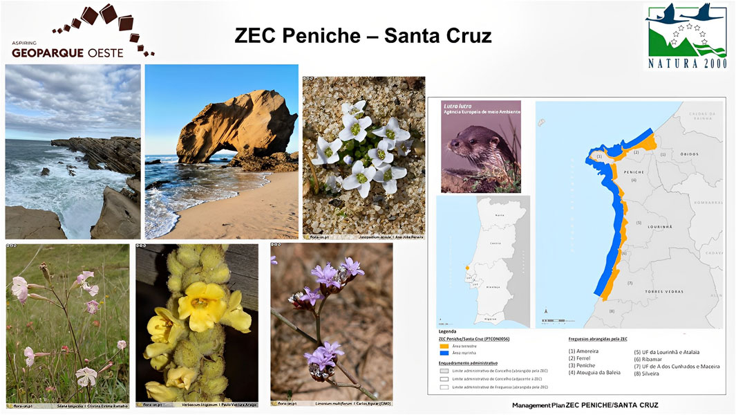
FIGURE 5. Peniche-Santa Cruz special conservation area. Source: produced by the authors.
It is located in the Lisbon and Tagus Valley Region and mainly comprises the municipality of Sintra, also covering a useful area of the municipality of Cascais, and to a lesser extent, the municipalities of Mafra and Torres Vedras (Figure 6). The management documents are the April 2020 Update Plan and Natura 2000 Sector Plan. The ICNF is the national management body (ICNF, 2020c) and three geosites are located 3 here.
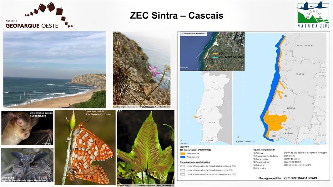
FIGURE 6. Sintra-Cascais special conservation area. Source: produced by the authors.
It was created with the aim of protecting the natural habitats of the fauna and flora in the “Monte Junto” mountain range, which has high floristic diversity and calcicole Lusitanian endemism (Figure 7). Management by the ICNF takes place through the Sector Plan of the Natura 200 Network. These overlap with the Serra de Montejunto Regional Protected Landscape (ICNF, 2020d; ICNF, 2020e; Natura Network, 2021). Three geosites are located 3 here.
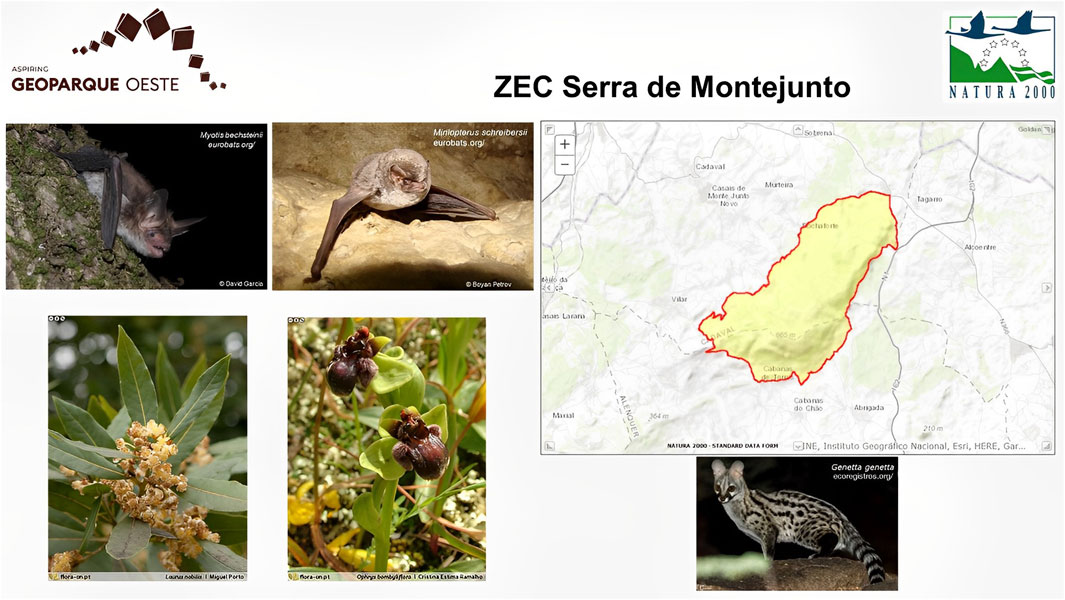
FIGURE 7. Serra de Monte Junto special conservation area. Source: produced by the authors.
At the national level in Portugal, Decree-Law No. 19/1993 of 23 January and established norms relating to the National Network of Protected Areas are followed. Derived from this regulation the Decree-Law No. 142/2008 of 15 July was amended, and republished by Decree-Law No. 242/2015 of 15 October that adds protected areas of regional/local scope (ICNF, 2020f). In Portugal, the classification “protected area” aims to grant a legal status of protection, at a national level, to the maintenance of biodiversity and ecosystem services and geological heritage, as well as the enhancement of the landscape (ICNF, 2020f).
Areas containing landscapes resulting from the harmonious interaction of human beings and nature and which show great aesthetic, ecological or cultural value. 2 - The classification of a protected landscape aims to protect the existing natural and cultural values, enhancing the local identity, and the adoption of measures compatible with the objectives of its classification, namely: 1) The conservation of the elements of biodiversity in a context of enhancement the landscape; 2) The maintenance or recovery of landscape patterns and the ecological processes that underlie it, promoting traditional land use practices, construction methods and social and cultural events; 3) The promotion of initiatives that benefit the generation of benefits for local communities, from products or the provision of services.
Created in 1999, it has 4,897.45 ha (Ministry of the Environment, 1999) of which 3,830.49 ha correspond to the Serra de Montejunto Special Conservation Area (Figure 8). Management takes place through the planning plans of the municipalities in the area. They have managing bodies, such as City Councils, that integrate the area. 1 aGO geosite is located here.
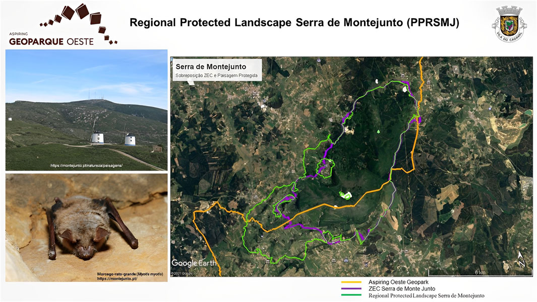
FIGURE 8. Serra de Montejunto regional protected landscape. Source: produced by the authors.
Created in 2015, it comprises the Serras do Socorro, Archeira, Galharda, and Monte Deixo (Figure 9). The Municipality of Torres Vedras is a management entity. The area does not have a Management Plan yet. Management tools include the Annual Monitoring Report and the “Landscape Observatory of the Local Protected Landscape of Serras do Socorro and Archeira” (Torres Vedras City Council, 2019). Here 2 aGO geosites are located.
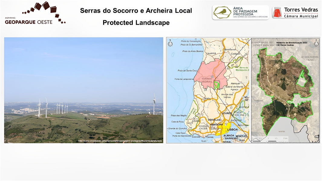
FIGURE 9. Serras do Socorroe e Archeira local protected landscape. Source: produced by the authors.
Natural reserve is defined as an area that contains ecological, geological and physiographic characteristics, or other types of attributes with scientific, ecological or educational value, and that are not permanently or significantly inhabited. 2 - The classification of a natural reserve aims to protect existing natural values, ensuring that future generations will have the opportunity to enjoy and understand the value of areas that have remained little altered by human activity during a prolonged period of time, and the adoption of measures compatible with the objectives of their classification, namely: 1) The execution of the necessary actions for the maintenance and recovery of species, habitats and geosites in a favorable state of conservation; 2) Conditioning visitation to a regime that guarantees minimum levels of disturbance to the natural environment; 3) Limiting the use of resources, ensuring the maintenance of the essential attributes and natural qualities of the area subject to classification.
This is a wetland of approximately 53 ha, protected by the Ramsar Convention since 2013 (Figure 4). The area does not have an approved Management Plan for consultation. It is governed by the regulations of the Municipal Master Plan Charter. The area is managed locally by the Municipality of Caldas da Rainha (Paul De Tornada Ecological Educational Center, 2021). 1 aGO geosite is located here.
The present study is classified as descriptive and exploratory. Regarding the approach, the research is characterized as qualitative by analyzing the organizational structures of different classified areas from the respective management documents. The technical procedure consisted of document consultation and on-site activities carried out between September 2020 and November 2021, comprising the four steps described in Figure 10.
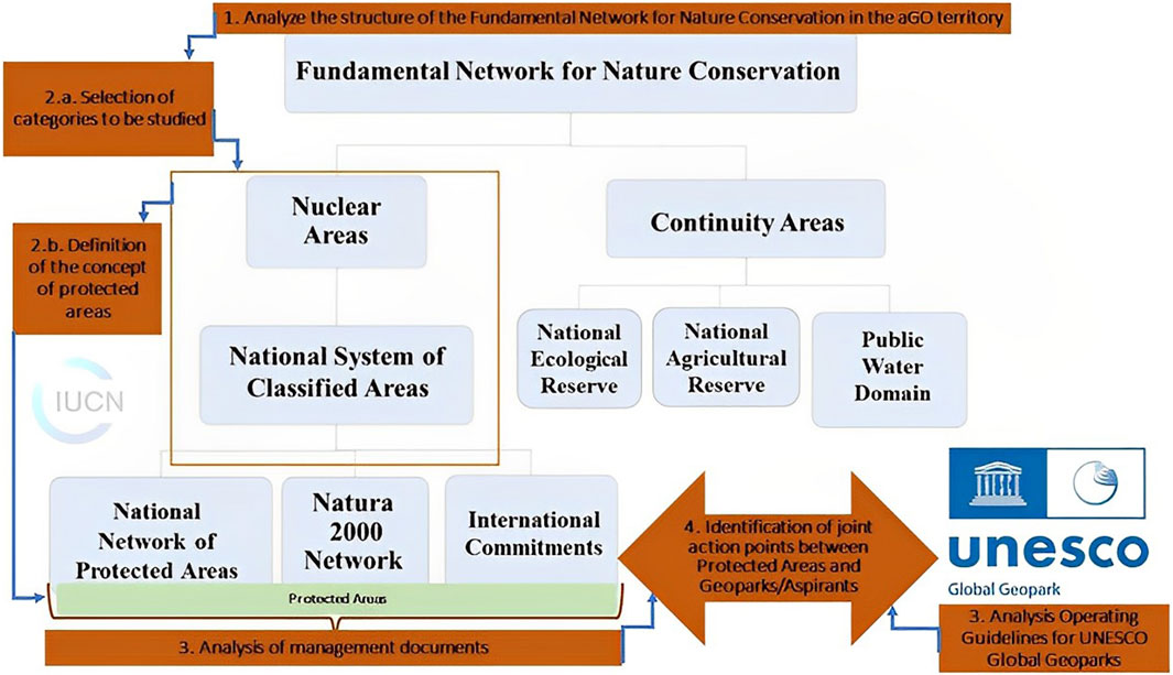
FIGURE 10. Research methodology. Source: elaboration based on Decree-Law No. 142/2008. On July 24, adapted by Nunes et al. (2016).
The territorial designations of sustainable management were analyzed according to the definitions of the Fundamental Network for the Conservation of Nature of Portugal. Decree-Law n. º 142/2008, in its Article 5, creates the Fundamental Network for Nature Conservation, which includes categories already existing in the legislation, composed of nuclear areas (National System of Classified Areas: Protected Areas, Natura 2000 and Areas under international commitments) and continuity areas: National Ecological Reserve, REN; National Agricultural Reserve, RAN; and Public Water Domain (Nunes, 2016).
Additionally analysed were the kmz (Keyhole Markup language Zipped) format files of the delimitation of these areas, available on the ICNF geocatalago platform (ICNF, 2020g).
This stage allowed for the understanding of classifications, hierarchies, laws, and mechanisms of creation, delimitation, and overlaps, as well as the responsible management body directing the other stages of the research.
Owing to the similarity of objectives and management mechanisms, this study considered all categories included in the subdivision “core areas”. Areas of continuity, areas of the private domain, and other designations of sustainable territorial management provided in Portuguese legislation, as well as other protection figures that do not have a legal regulatory mechanism, were not considered in this study.
For the definition of the term “protected areas” or “protected natural spaces,” this study considered the proposal by the International Union for Conservation of Nature in 2008, which denominates as “protected natural areas that are clearly defined, recognised, destined, and managed geographic spaces,” by legal means or other efficient alternatives, with the aim of conserving, in the long term, nature, ecosystem services and cultural values” (International Union for Conservation of Nature, 2020). Thus, in this case study, the term “protected areas” encompasses all areas included in the National System of Classified Areas in Portugal that comply with this definition, that is, the areas of the National Network of Protected Areas, Natura 2000, Biosphere Reserve and Ramsar Site.
The organisational structures of areas designated for the protection and conservation of the natural heritage already established in the aGO territory was consulted.
The documents considered for this analysis were legal statutes for the creation of classified areas and other legislation relevant to the Fundamental Network for Nature Conservation, according to the legislation in force at Portugal: management data from the Institute for the Conservation of Nature and Forests (Portugal), legal statutes and Standard Data Forms of the European Environment Agency; Ramsar Convention Strategic Plan; and Operating Guidelines for UNESCO Global Geoparks. All of these are available for consultation on the respective websites.
Among the field activities, a meeting was held with members of the Torres Vedras City Council, responsible for the management of the Local Protected Landscape of Serras do Socorro and Archeiro, who presented the activities carried out in this protected area and described the possible points of joint action with aGO. Data on the management model, evaluation system, and indicators were sent via email. At this meeting, an interview was held with the following questions:
1. What is the structure and management model of the Serras do Socorro and Archeira protected area?
2. If the protected area has a Management Plan drawn up and approved;
3. What are the management indicators?
4. Which activities are developed with the participation of local communities?
5. What are the possible points of joint action/collaboration between the Serras do Socorro and Archeira protected area and a UNESCO Global Geopark?
6. Does the management group support the development of the project for the creation of a UNESCO Global Geopark in the territory?
The activities of the aGO team were also monitored regarding the establishment of formal partnerships with the managers of classified areas as well as the formulation of actions to promote, preserve, and conserve these spaces. A meeting was also held with the aGO team to characterise the areas of the Fundamental Network for Nature Conservation inserted in the applicant’s territory. At these two moments, participants’ considerations were collected on joint actions and the promotion of protected areas.
Classified Areas in the public domain were analysed in terms of 1) Goals; 2) Management model and managing body, and 3) Objectives aligned with the proposal of the aspiring Oeste Geopark according to the criteria of the UNESCO Earth Sciences and Geoparks Program. A list of all the objectives of each of the studied protected areas was created in the same table. These objectives were compared with 12 criteria of UNESCO World Geoparks and Aspirants that include: 1) Geological Heritage Conservation; 2) Involvement with Natural Conservation; 3) Engagement with Cultural Conservation; 4) Education; 5) Research; 6) Geotourism; 7) Promotion of Natural Heritage; 8) Sustainable Development; 9) Participation of local communities; 10) Support to local communities; 11) Networking; and 12) International Cooperation. These criteria were obtained from the UNESCO Statutes of the International Program of Earth Sciences and Geoparks.
For each objective of the areas classified in line with UNESCO criteria, one point was assigned so that the total score allowed the identification of the pillars of joint actions and how each UNESCO criterion appeared in the management documents of protected areas, portraying convergence or divergence.
When analysing the guiding objectives of each classified area correlated with the criteria that the UNESCO Geoparks and aspirants must meet, the synergistic performance of these protection figures was observed. The establishment of a partnership between the aspiring Geopark Oeste and the classified areas in its delimitation can directly or indirectly cover activities that meet these objectives and criteria. This is described in Supplementary Table S1.
The criteria Involvement with Natural Conservation (B) and Sustainable Development (H) permeated all the objectives of each of the analysed protected areas; therefore, they presented higher scores, outlining the main similarities and convergences between geoparks and protected areas.
Owing to the geomorphological characteristics of the territory, the Geological Heritage Conservation criterion A) is consistent with at least one objective in each of the seven protected areas, which have the conservation of the landscape and/or habitats linked to the geological heritage. Only the designation of the Ramsar Site does not present objectives directly related to geological heritage. Thus, this criterion is the second with the highest score, that is, in alignment for joint actions.
The criteria for the Promotion of Natural Heritage (G), Education (D), and participation of local communities (I) did not score in the categories of the Natura 2000 Network. These areas focus on the conservation of species and habitats and are aimed at the concept of integral protection. The other protected areas have, in their objectives, the dissemination and promotion of these spaces, assigning 11 points to criterion G, which is the third with the highest alignment.
The education criterion is included in objectives related to dissemination and impact reduction, totaling nine points. However, it appears clearly expressed only in one objective of the Paul da Tornada Local Natural Reserve “7a.2. promotion of environmental education activities as a presupposition of a more harmonious relationship between man and the environment”; an objective of the Berlengas-Peniche Biosphere Reserve “1.3. Research, monitoring, dissemination, and environmental awareness; and an objective of the Local Protected Landscape of Serras do Socorro and Archeiro “6.5. Develop educational and scientific practices for the definition and study of environmental, natural, and cultural values, with the active participation of local communities, with a view to harmonious and sustainable human development.”
The participation of local communities (I), in addition to not being included in the objectives of the areas of the Natura 2000 Network, is also not expressly included in the objectives of the Serra de Montejunto Regional Protected Landscape. Totalling 9 points, this criterion stands out in the objectives of the Ramsar Paul da Tornada Site, the Local Protected Landscape of Serras do Socorro, Archeiro, and the Berlengas-Peniche Biosphere Reserve.
The criteria for Involvement with Cultural Conservation (C), Geotourism (F), Research (E), Support for Local Communities (J), Networking (L), and International Cooperation M) scored less than five points, portraying gaps that diverge from the holistic concept of conservation of natural heritage. Consequently, the main aspects of improvements in the efficiency of territorial management may result from the implementation of the geopark designation in the region under study.
Engagement with Cultural Conservation (C) is pertinent to the objectives of the Berlengas-Peniche Biosphere Reserve and the Local Protected Landscape of Serras do Socorro and Archeiro. Geotourism (F) does not appear to be expressed in any of the objectives; however, given the geological relevance of tourism in the region, those that included actions for tourism were considered. Thus, this criterion is present in the objectives of the Berlengas-Peniche Biosphere Reserve, Serra de Montejunto Regional Protected Landscape, Serra do Socorro, Archeiro Local Protected Landscape, and Paul da Tornada Local Natural Reserve.
Criteria of Research (E), Support for local communities (J), Networking (L), International Cooperation (M) had the lowest scores in this analysis.
Research (E) and Support to local communities (J) are only considered in the objectives of the Berlengas-Peniche Biosphere Reserve, Local Protected Area of Serras do Socorro, Archeiro, and Ramsar Site Paul da Tornada. The Ramsar Sites Strategic Plan inserts scientific guidance as one of its goals (Goal 4) and considers participating in and supporting local communities in the efforts necessary to achieve Goal 2.
Networking (L) is present in all objectives of the Strategic Plan for Ramsar Sites and International Cooperation (M) in objectives 1 and 2. This document highlights partnerships at various levels, including local, national, and international, as well as between all Ramsar Network Sites, and shared equally, between these sites and local communities, institutions, NGOs, and various social actors.
In addition to the points of joint action identified in the document analysis, the record of evaluations and suggestions from the managing members of the Local Protected Landscape of Serras do Socorro and Archeiro and the aGO team indicated new points and reinforced others identified in the document analysis.
The actions to encourage geotourism and support local communities were indicated by the management team of the Local Protected Landscape of Serras do Socorro and Archeiro as the main points of cooperation that correspond to expectations and needs in relation to the joint work between the Local Protected Landscape of Serras do Socorro and Archeiro and aGO.
The members of the aGO team also indicated as possibilities for joint action in the technical and institutional support for the elaboration of Management Plans for protected areas that do not yet have them or have concluded their elaboration. Within the scope of technical support derived from UNESCO criteria for conservation and promotion of natural heritage, mutual training between the GO and protected areas is also on the list of activities.
Considering the above, the protected areas with the greatest similarity between UNESCO’s objectives and criteria are the Berlengas-Peniche Biosphere Reserve and the Local Protected Landscape of Serras do Socorro and Archeiro. The Ramsar Paul da Tornada site shows greater convergence with UNESCO criteria in terms of networking and international cooperation. The areas of the Natura 2000 Network (Special Area of Conservation Peniche-Santa Cruz, Special Area of Conservation Sintra-Cascais, and Special Area of Conservation Serra de Monte Junto) present more disparities.
The results of the analyses indicate that the overlap of the different designations of areas and territories studied here can act both in a joint and complementary way to conserve natural heritage.
Simultaneously, cohabitation requires action planning based on communication and joint work to avoid conflicts between the management of these spaces and confusion on the part of the community (Finke, 2013; Osipova et al., 2017).
Understanding the categories and objectives of the spaces studied guides the development of activities, extracting the advantages of each designation and inserting them into a common roadmap that achieves the conservation of natural heritage and sustainable development.
The protected areas established in this territory have a history of years carrying out nature conservation activities with positive results and notoriety with the local population and visitors. On the other hand, with the implementation of the aGO, the development of the criteria Involvement with Cultural Conservation (C), Geotourism (F), Research (E), Support for local communities (J), Networking (L) and International Cooperation (M) can promote integration in the territory and contribute to solving existing weaknesses in the system of protected areas.
A geopark is different from many existing parks and protected areas to add a change in the way the landscape is understood, bringing positive impacts on environmental and economic aspects by promoting the territory at an international level, and for developing educational and interpretive activities with the main objective of educating visitors and the community (Moreira et al., 2021).
This study justifies the proposal of a synergistic action that considers the development of the following criteria: Involvement with Cultural Conservation (C), Geotourism (F), Research (E), Support for local communities (J), Networking (L) and International Cooperation (M). For this reason, the establishment of partnerships between the aGO and the designations studied, in addition to having nature conservation and sustainable development as the main axes, must be supported by four pillars, as shown in Figure 11.
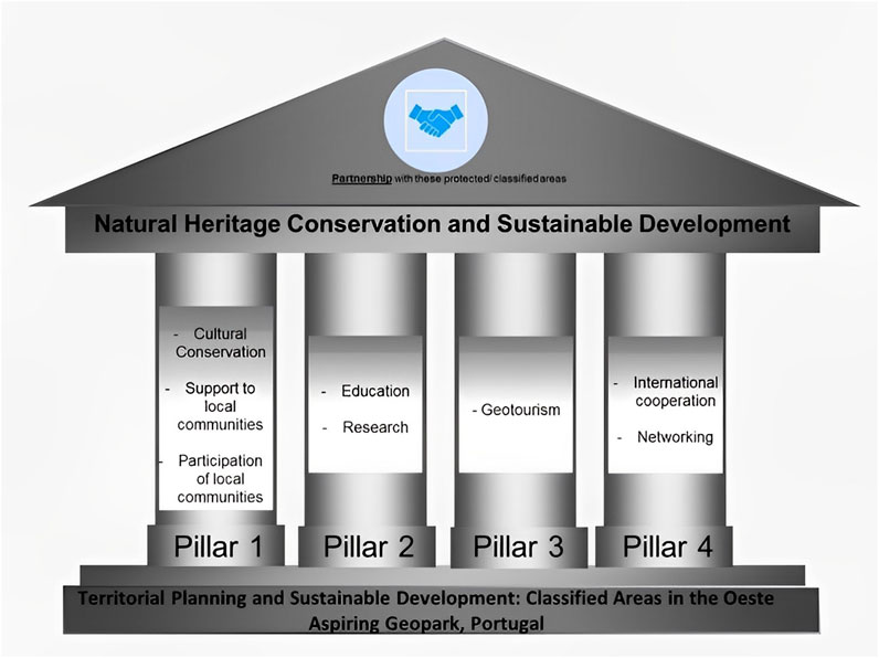
FIGURE 11. Pillars for joint action between classified areas in the aGO territory. Source: produced by the authors.
The first pillar directs actions that involve the local community, working for the conservation of cultural heritage, support local communities, and participation of these communities. Understanding changes in the landscape over time related to historical and cultural aspects can be a tool for environmental awareness (Cardoso, 2012) and the cultural relevance of geoheritage is widely recognised and can form environmental management strategies (Pijet-Migo’n and Migo’n, 2022). Likewise, the activities of geoparks to rescue and enhance local cultural values include components that carry out the process of internalizing and living the values in their personalities, associating themselves with the community, and developing a more prosperous community life where there is greater interest towards environmental and scientific issues (Budiastra et al., 2021).
Regarding the association between protected areas and geoparks, the involvement of the local community is influenced by the historical relationship between the government and local communities, perceptions of nature protection, and attitudes towards the economic gain of nature (Mammadova et al., 2022), elements that must be observed in the construction of pillar 1.
The second pillar emphasises scientific knowledge and its transfer to society at different levels of formal and informal education. In addition to the importance of scientific production, making it reach the communities is a challenge in several fields of knowledge. For environmental education, its full promotion has been made possible by the geoparks program, as there is the integration of local communities with the environment; thus, the mechanisms of environmental awareness of society and visitors to the area are intensified (Salvetti, 2020). In other words, the process of Environmental Education in protected areas should adopt models observed for geoparks (Bacci, 2015).
Environmental education, developed in Portuguese geoparks, seeks to maintain close and active relationships with schools, teachers, and students through educational programmes to support conservation goals (Bacci, 2015).
Protected areas at the European and national levels in Portugal (ICNF b), as well as UNESCO Biosphere Reserves and Geopark designations, must be operated based on scientific knowledge; therefore, they need close collaboration between local authorities and universities (Mammadova, 2021). In Japanese local communities, the integration of UNESCO Biosphere Reserves and Geoparks into the educational curriculum provides site-specific knowledge and functions as a learning platform to teach about the link between human and nature interaction for regional sustainable development, and needs to be worked together to avoid confusion about common goals (Mammadova, 2021).
In addition, environmental education also benefits from the association of geoparks with protected areas that are already established or that will be created in the future, as the latter already have a legal regiment that can facilitate procedures with regulatory bodies for the development of educational activities that are non-formal or can be included in school curricula (Salvetti, 2020).
The third pillar is geotourism, in which protected areas play a fundamental and relevant role in geoparks, reinforcing the need to strengthen partnerships in territories with overlaps. Geodiversity is the main source of support for the development of geotourism, and the existence of biodiversity and cultural diversity adds value to tourists and helps preserve it (Lee and Karimova, 2021; Wulung et al., 2021).
The promotion of geotourism through protected areas and popular natural attractions increases socioeconomic, cultural, and environmental knowledge and promotes actions carried out in a territory (Quesada-Román et al., 2022) and can be a valuable opportunity for community development locations with numerous benefits (Zafeiropoulos et al., 2021). The use of the local richness and diversity of Natural Parks in Portugal, both from a landscape and cultural perspective, can be a tourist resource that must be promoted in an integral way, adding value to this type of tourist experiences (Ferreira and Sanchez Martín, 2021).
The fourth pillar of joint action is international cooperation and networking. These two aspects promote the entire territory at an international level, contributing to scientific, technological, educational, and tourist development (Zouros, 2004). The establishment of partnerships benefits the territory for international recognition and prestige, as a marketing tool for the region that can promote the region to new visitors, as well as enable international partnerships in various fields (Moreira et al., 2021).
Therefore, these pillars can help in understanding the roles of each member of a partnership and their points of cooperation. Since multiple titles and overlaps of areas and territories can cause divergence in terms of objectives and management models, confusion in the identification system and pressure on public administration, communication, and coordination between the institutions and departments involved in management is essential (Finke, 2013; Osipova et al., 2017).
Overcoming the problem of overlapping protected area boundaries caused by overlapping multi-internationally designated areas and delimitation of scientifically protected areas have been of considerable importance in achieving efficient management of natural protected areas in Jiangshan, China (Gao et al., 2022). As a solution, a technical structure was proposed for the delimitation of natural reserves through an evaluation index system for the integration and optimisation of the reserves, resulting in guidelines on the delimitation of the perimeter and integration of these areas, including discussing the delimitation criteria and the possibility of modifying them for more satisfactory management, fulfilling the objective of conserving natural heritage.
For the areas of the National Network of Protected Areas of Portugal protected by specific law, the pillars of joint action presented in Figure 4 can direct the focus of the partnership with the aGO. This complementation is understood as positive because the UNESCO criteria can contribute to gaps in protected areas regarding the involvement of society, education, and research. The perspective of international cooperation can be an important driver for the promotion of protected areas as well as for tourism development.
The Natura 2000 Network focuses on biodiversity in the context of the conservation of habitats and species of fauna and flora. Despite the objectives of these areas having scored only three UNESCO criteria, since they are inserted in a territory of geological relevance, the conservation of habitats is consistent with the conservation of geological heritage. The aspects of community support and participation, presented in pillar 1, can be delicate in the areas of the Natura 2000 Network; however, overcoming these conflicts is also a demand in areas that are more oriented towards integral protection. They need to develop holistic and inclusive processes that consider multiple dimensions of conflict (Andonegi et al., 2021). This requires close collaboration of the scientific team with various social actors, who represent the perspectives confronted, as non-experts can often see problems and solutions that specialists do not perceive (Andonegi et al., 2021).
Thus, as in the areas of the National Network of Protected Areas in Portugal, it is recommended that Special Areas of Conservation develop the pillars proposed in this study. During the monitoring of the activities of the aGO team, the request for a partnership with the managing body, the ICNF, was registered through meetings and by sending an official document for signature and formalisation of the partnership through a protocol. This procedure is under analysis by the managing body.
As for the internationally designated areas (Ramsar Sites, World Heritage Sites, UNESCO Biosphere Reserve, and World Geoparks), the Ramsar Paul da Tornada Site and the Berlengas-Peniche Biosphere Reserve have scores that are common to almost all UNESCO criteria for geoparks and aspirants owing to the international character of these three designations. Although the purposes of BR and UNESCO Global Geoparks (UGGp) differ, one of the main purposes of these two programmes is the participation and involvement of local communities in economic activities for regional, economic, social, and environmental development, which are the three dimensions of sustainable development supported by UNESCO (Mammadova et al., 2022).
The Ramsar Sites Strategic Plan does not expressly address the conservation of geological heritage; however, it reinforces the importance of partnerships with local institutions for all its strategic objectives. In particular, Paul da Tornada presents a relationship with the geological aspects inserted in the scope of action of the aGO in its historical ecosystem composition. The complementarity of these designations is particularly positive in terms of international cooperation, providing visibility, and greater possibilities for financing its activities.
The methodological analysis adopted in this study allowed us to clarify the limits of the overlapping of the aGO on the Berlengas-Peniche Biosphere Reserve, directing the actions to the terrestrial part of the transition zone of the Reserve, that is, the Peniche Peninsula. The possibilities of joint actions in other areas of the reserve are not excluded here, especially regarding education and scientific research; however, actions with the local community are considered a priority according to the proposal of synergistic action and respective pillars in the present study. International cooperation and promotion of reserves are also priorities.
This harmonious relationship between different designations within a common territory agrees with other studies of multi-internationally designated areas (MIDAs). The case study of Jeju Island Autonomous Province, Republic of Korea (Clamote Rodrigues and Schaaf, 2016) contemplates the four distinct international designations and concludes that the multiple designations led to a high level of local awareness about the critical connections between environmental conservation and sustainability. Overcoming the challenges consisting of effective governance based on synergy between the different objectives of each area. Recommendations are also made for managers at the local level, for authorities and focal points at the national level, and for designating bodies at the international level. The pillars of the synergistic action proposed for the AGO territory is in line with these recommendations.
Thus, for the alignment between classified areas, the synergistic action proposal presented here denotes an approach regarding the understanding of space and the establishment of the relationship between territory and identity (Sánchez Cortez, 2011). The definition of landscape and territory can be complex and emblematic, as its meaning is loaded with symbolism and representations, both from the point of view of its subjective perception and its objective perception. Landscape design must therefore be holistic and multi-disciplinary, and can be analysed in its particularity as an external aspect of an area–the territory (Silva, 2018).
UNESCO criteria listed as gaps (cultural conservation, geotourism, research, support for local communities, networking, and international cooperation) are aspects of the human component which must be present in sustainable territorial management.
Thus, the work carried out by UNESCO Global Geoparks is important from a holistic point of view when considering local communities as creating a strong identity based on the connection with the natural aspects of the territory (Sánchez Cortez, 2011).
In addition to the geopark structure the Man and Biosphere (MAB) Programm contributes to sustainability science, this network became an embodiment of sustainability science, by implementing a use-inspired, transdisciplinary research and action program at the human–environment interface (Reed, 2019). UNESCO Programs and Chairs offer a list of actions directly within the objectives of sustainable development, allowing citizens an integrated understanding of their territory (Bergman et al., 2018). These sustainability principles can positively guide management towards the preservation of biodiversity.
This holistic, inclusive, and integrative conception of heritage has been the core of the most recent international doctrine in which the participation of the entire community that enjoys it is fundamental (Silva, 2018). Thus, we have the construction of an “environmental knowledge” which implies a deconstruction of disciplinary, simplifying, unitary knowledge. This is a permanent debate in the face of conceptual categories and ways of understanding the world, forming social actors responsible for natural heritage (Leff, 2009).
There are Protected Areas where this holistic concept has already been developed in their management. However, it is still one of the challenges for many of these natural spaces that have little or no structure for their actions. Therefore, the establishment of UNESCO World Geoparks can make a significant contribution.
Therefore, the “gaps” criteria must be the focus of joint action for the effective management of the territory. Other protection figures must also be considered in a synergistic relationship with aGO territories.
The different designations for sustainable territorial management present complementary actions that favour the conservation of natural heritage. No points of divergence were identified between the criteria of the UNESCO Geopark Program and the objectives of the classified areas already established in the territory of the present case study. Such complementarity is already obvious from the different aspects of natural heritage (geodiversity and biodiversity) addressed in each designation. For the same reason that these aspects are intrinsic in nature, cooperation between these designations must be equally intrinsic.
Even though the Geoparks work more incipiently with local communities, the classified areas also envisage environmental education actions. Both mechanisms cooperate at different timescales, highlighting the importance of joint action in overlapping and/or bordering territories.
The aspects of geoparks concerning the active participation and appreciation of the local population in a concrete way and under a four-year evaluation can be an important factor for the conservation and preservation of natural heritage when considering the human component in an integrated way with nature.
Although protected areas have legal mechanisms established with clear rules of use and restrictions, they contribute to curbing the aggressive exploitation of natural resources. In this way, they can act on an emergency level, while the geoparks propose short-, medium-, and long-term result actions. The emergency nature of protected areas is fundamental, especially in countries where geodiversity and biodiversity are being rapidly destroyed. These protection figures represent advances in the conservation of natural heritage sites.
This case study reinforces that the different designations of areas and/or territories for sustainable territorial planning at local, regional, national, and international levels are fundamental to nature conservation, requiring more effort in terms of efficient management and integration of the social component.
For future research in this field, it would be useful to analyze other protection figures included in the Fundamental Network for Nature Conservation of Portugal (areas of continuity) and other mechanisms of this country, such as master and planning plans. As for the aGO, with the finalization of the strategic plan for this territory and approval of the candidacy for UNESCO’s World Geopark, an assessment is recommended if these joint actions are being carried out. It is also necessary to produce more exhaustive analyses in different countries to improve knowledge about the joint action of protected areas and geoparks, as each country has its own legislation for protected areas.
The original contributions presented in the study are included in the article/Supplementary Material, further inquiries can be directed to the corresponding author.
All the authors contributed substantially to this study. The task of the study conception and design, manuscript preparation and writing, as well as critical review was developed as a group. Author DA was especially responsible for conceptual and theoretical development, data acquisition, and technical procedures. RR and MS-OS were responsible for the data evaluation, interpretation, analysis, review, and editing.
This research received financial support from funds from the Erasmus + UEx Quercus Program (Proyecto 2019-1 ES01-KA103-061559).
The authors would like to thank Associação Geoparque Oeste (AGEO) for supporting this study.
The authors declare that the research was conducted in the absence of any commercial or financial relationships that could be construed as a potential conflict of interest.
All claims expressed in this article are solely those of the authors and do not necessarily represent those of their affiliated organizations, or those of the publisher, the editors and the reviewers. Any product that may be evaluated in this article, or claim that may be made by its manufacturer, is not guaranteed or endorsed by the publisher.
The Supplementary Material for this article can be found online at: https://www.frontiersin.org/articles/10.3389/fenvs.2023.1132162/full#supplementary-material
Altieri, M. A. (1995). The “state of the art” of agroecology and your contribution for rural development in Latin America, in A. Cadenas Marín Agriculture and sustainable development (MA) (Madrid: MAP), 151-203.
Andonegi, A., Garmendia, E., and Aldezabal, A. (2021). Social multicriteria assessment for managing conflicts in biodiversity conservation. Land 109, 1–14. doi:10.1016/j.landusepol.2021.105658
Associação Geoparque Oeste (2021). The territory. Available at: https://www.geoparqueoeste.com/menu/665/o-territorio (Accessed December 19, 2020).
Bacci, D. C. (2015). Geosciences and environmental education. 1st Digital Edition, cap. 8 and 10. Curitiba: Ponto Vital Publisher–252. Available at: https://jornal.usp.br/wp-content/uploads/geociencias_ebook.pdf.
Bergman, Z., Bergman, M. m., Fernandes, K., Grossrieder, D., and Schneider, L. (2018). The contribution of UNESCO Chairs toward achieving the UN sustainable development goals. Sustainability 10 (12), 4471. doi:10.3390/su10124471
Budiastra, A. A. K., Puspitasari, S., Wicaksono, I., and Erlina, N. (2021). Study of the local wisdom curriculum of geopark belitung to support local cultural values in context of natural science learning for elementary school. Adv. Soc. Sci. Res. J. 8, 692–706. doi:10.14738/assrj.85.10280
Canton, V. (2007). Protected areas as support tools for territorial management. Theoretical approach to the issue and analysis of a practical situation at the national level. Master 's Dissertation. Montevideo (UY): Universidad de la República. (Faculty of Architecture).
Cardoso, S. B. A. (2012). Perception of the landscape as a tool to raise awareness in aid of environmental education. postgraduate thesis. Santa Maria (BR): Federal University of Santa Maria.
Castanho, R. A. M. D. (2017). Sustainable urban planning in transboundary areas: Analysis of critical factors for territorial success. doctoral thesis. Cáceres (ES): Universidad de Extremadura. Dehesa Institutional Repository. Available at: https://dehesa.unex.es/handle/10662/6133 (Accessed 2 5, 2022).
Chaves, M. P. S. R., and Barros, J. F. (2022). Territorial governance in protection policies in protected areas: A comparative study between Brazil and France. Inc. Soc. 14, 143–162. https://revista.ibict.br/inclusao/article/view/5895/5504
Clamote Rodrigues, D., and Schaaf, T. (2016). Managing MIDAs: Harmonising the management of multi internationally designated areas: Ramsar sites, world heritage sites, Biosphere reserves, UNESCO global geoparks, xvi. Gland, Switzerland: International Union for Conservation of Nature and Natural Resources, 140.
Dong, Q., Zhang, B., Cai, X., and Morrison, A. M. (2021). Do local residents support the development of a national park? A study from nanling national park based on social impact assessment (sia). Land 10, 1019. doi:10.3390/land10101019
N. Dudley (Editor) (2008). Guidelines for applying protected area management categories (Gland, Switzerland: IUCN), 86. ISBN: 978-2-8317-1086-0.
Duval, V. s., and Benedetti, G. M. (2019). Natural heritage conservation policy in Argentina. Finisterra LIV, 101–118. doi:10.18055/finis17108
Farsani, N. T., Coelho, C., and Costa, C. (2010). Geotourism and geoparks as novel strategies for socio-economic development in rural areas. Int. J. Res. Tour. Res. 13, 68–81. doi:10.1002/jtr.800
Ferreira, D. I. R., and Sánchez Martín, J. M. (2021). The olive grove as an opportunity for tourism in the International Tagus Nature Reserve. Finisterra 56 (117), 55–80. doi:10.18055/Finis19241
Ferreira, E. D. H. (2013). Wetlands as pollution purifiers Case of Paul de Tornada. Master’s dissertation. Lisboa (PT): Universidade Nova de Lisboa. New University Repository. Available at: https://run.unl.pt/handle/10362/12088.
Finke, G. (2013). Linking landscapes: Exploring the relationships between world heritage cultural landscapes and IUCN-protected areas in the IUCN World Heritage Study. Gland, Switzerland: IUCN, 26. Nº11.
França, S. F., and Martins, E. S. (2020). The double face of the polygons configures the environmental and historical micro-region of Chapada dos Veadeiros. LV, 175–194. doi:10.18055/finis16975
Gao, H., Weng, Y., Lu, Y., and Du, Y. (2022). An innovative framework on spatial boundary optimization of multiple international designated land use. Sustainability 14 (2), 587. doi:10.3390/su14020587
Giraldo-Ospina, T., and Zumbado-Morales, F. (2020). Gestión Territorial y sus implicaciones con los ODS11: Reflexiones desde Colombia y Costa Rica. Rev. Arquit. 22, 141–152. doi:10.14718/RevArq.2020.3033
Henrique, R., and Toniolo, M. A. (2021). Territorial planning and sustainable development: The case of the são francisco xavier EPA -sp. Ambiente and sociedade. São Paulo 24, 1–2. doi:10.1590/1809-4422asoc20200041r1vu2021L5AO
Henriques, M. H., and Brilha, J. (2017). UNESCO global geoparks: A strategy towards global understanding and sustainability Episode 40, 349–355. doi:10.18814/epiiugs/2017/v40i4/017036
Henriques, M. H., and Tomaz C, S. A. A. (2012). The arouca geopark (Portugal) as an educational resource: A case study. Episodes 35, 481–488. doi:10.18814/epiiugs/2012/v35i4/004
Institute for Conservation of Nature and Biodiversity (ICNB) (2007). Management plan for Berlengas nature reserve. Portugal: ICNB. Available at: https://www.icnf.pt/api/file/doc/849ab1cd147a0637 (Accessed December, 2020).
Institute for Conservation of Nature and Forests (2020a). Ecosystems. Lisbon: ICNF. Available at: http://www2.icnf.pt/portal/icnf/faqs/zif (Accessed December, 2020).
Institute for Conservation of Nature and Forests (2020b). Management plan for ZEC peniche-santa Cruz areas of conservation: Peniche-santa Cruz. Lisbon: ICNF. Available at: https://participa.pt/pt/consulta/plano-de-gestao-da-zec-peniche-santa-cruz (Accessed December, 2020).
Institute for Conservation of Nature and Forests (ICNF) (2020c). ZEC Sintra-Cascais management plan. Lisbon: ICNF. Available at: https://participa.pt/pt/consulta/plano-de-gestao-da-zec-sintra-cascais (Accessed December, 2020).
Institute for Conservation of Nature and Forests (2020d). Natura 2000 network. Lisbon: ICNF. Available at: http://www2.icnf.pt/portal/pn/biodiversidade/rn2000 (Accessed November, 2020).
Institute for Conservation of Nature and Forests (ICNF) (2020e). Natura 2000 Network sector plan. Lisbon: ICNF. Available at: http://www2.icnf.pt/portal/pn/biodiversidade/rn2000/p-set/qe (Accessed November, 2020).
Institute for Conservation of Nature and Forests (ICNF) (2020f). Protected areas. Lisbon: ICNF. Available at: http://www2.icnf.pt/portal/ap (Accessed November, 2020).
Institute for Conservation of Nature and Forests (ICNF) (2020g). Geographic information. Lisbon: ICNF. Available at: https://geocatalogo.icnf.pt/catalogo.html (Accessed November, 2020).
Lee, K.-C., and Karimova, P. G. (2021). From cultural landscape to aspiring geopark: 15 Years of community-based landscape tourism in fengnan village, hualien county, taiwan (2006–2021). Geosciences 11, 310. doi:10.3390/geosciences11080310
Leff, E. (2009). Complexity, environmental rationality, and knowledge dialogue. Education and reality. Educ. Real. 34, 17–24. https://www.redalyc.org/pdf/3172/317227055003.pdf
Li, J., Stoffelen, A., and Vanclay, F. (2022). A conceptual framework and research method for understanding protected area governance: Varying approaches and epistemic worldviews about human-nature relations. J. Environ. Plan. Manag., 1–20. doi:10.1080/09640568.2022.2034605
Loureiro, F., Sousa, M., Basto, M., Pedroso, N., Rosário, J., Sales-Luís, T., et al. (2007). The non-flying community in the protected landscape of Serra de Montejunto (central Portugal): Distribution and regional situation. Galemys 19, 139–157. https://dialnet.unirioja.es/servlet/articulo?codigo=2525363
Mammadova, A., Redkin, A., Beketova, T., and Smith, C. D. (2022). Community engagement in UNESCO biosphere reserves and geoparks: Case studies from mount hakusan in Japan and altai in Russia. Land 11, 227. doi:10.3390/land11020227
Mammadova, A. (2021). Integrating Japanese local government and communities into the educational curriculum on regional sustainability inside the UNESCO’s biosphere reserves and geoparks. Sustainability 13, 2497. doi:10.3390/su13052497
Medeiros, C. A. F., Gomes, C. S. C. D., and Nascimento, M. A. L. (2015). Gestão em Geoparques: Desafios e Realidades. Rev. Bras. Pesqui. em Tur. 9, 342–359. doi:10.7784/rbtur.v9i2.798
Melo Filho, D. C. (2021). UNESCO missions in Lusophone Africa: Forging heritage and forging territories. Finisterra LVI, 241–252. doi:10.18055/Finis23942
Mora, S. A. (2009). Basic concepts and guidelines for the management of protected areas. San José (CR): University for International Cooperation. Repository. [End-of-course work]. Available at: https://www.ucipfg.com/Repositorio [Accessed 5/2/2022].
Moreira, J. C., Vale, T. Fd, and Burns, R. C. (2021). Fernando de Noronha archipelago (Brazil): A coastal geopark proposal to foster the local economy, tourism and sustainability. Water 13, 1586. doi:10.3390/w13111586
Natura network (2021). Natura. 2000 network viewer. Available at: https://natura2000.eea.europa.eu/ (Accessed January 10, 2021).
Nunes, D. F. (2016). Methodological contributions for the planning of protected area case study: Protected site landscape Socorro and Archeira mountains. Master’s Degree. Tomar Portugal. Institute Polytechnic de Tomar. (Common Repository). Available at: https://comum.rcaap.pt/handle/10400.26/18524 [Accessed 5/1/2021].
Osipova, E., Shadie, P., Zwahlen, C., Osti, M., Shi, Y., Kormos, C., et al. (2017). IUCN world heritage outlook 2: A conservation assessment of all natural world heritage sites. Gland, Switzerland: IUCN, 92.
Pásková, M., and Zelenka, J. (2018). Sustainability management of UNESCO global geoparks. Sustain. Geosci. Geotourism. 2, 44–64. doi:10.18052/www.scipress.com/SGG.2.44
Paul De Tornada Ecological Educational Center (2021). Paul de Tornada local natural reserve. Available at: http://www.ceept.pt/ (Accessed December 10, 2021).
Pellizzaro, P. C., Hardt, L. P. A., Hardt, C., Hardt, M., and Sehli, D. A. (2015). Management of protected natural areas: International context. Environ. Soc. 1, 21–40. doi:10.1590/1809-4422ASOC509V1812015en
Pérez Rubio, J. (2007). “Sociology and development,” in The right of sustainable development (Madrid: Ministry of Agriculture, Fisheries, and Food), 516.
Pijet-Migoń, E., and Migoń, P. (2022). Geoheritage and cultural heritage—a review of recurrent and interlinked themes. Geosciences 12, 98. doi:10.3390/geosciences12020098
Portuguese Republic (2008). “Decree law Nº 148 of 2008,” in Legal framework for the conservation of nature and biodiversity, 1–28. Available at: https://dre.pt/dre/legislacao-consolidada/decreto-lei/2008-34502775-47925475 (Accessed October, 2020).
Quesada-Román, A., Torres-Bernhard, L., Ruiz-Álvarez, M. A., Rodríguez-Maradiaga, M., Velázquez-Espinoza, G., Espinosa-Vega, C., et al. (2022). Geodiversity, geoconservation, and geotourism in central America. Land 11, 48. doi:10.3390/land11010048
Ramsar Site (2021). Ramsar site information service. Available at: https://rsis.ramsar.org/es/ris/1106 (Accessed February, 2021).
Reed, M. G. (2019). The contributions of UNESCO Man and Biosphere Programme and biosphere reserves to the practice of sustainability science. Sustain Sci. 14, 809–821. doi:10.1007/s11625-018-0603-0
Rodrigues, J., Carvalho, C. N., Ramos, M., Ramos, R., Vinagre, A., and Vinagre, H. (2021). Geoproducts – innovative development strategies in UNESCO geoparks: Concept, implementation methodology, and case studies from naturtejo global geopark, Portugal. Int. J. Geoheritage Parks 9, 108–128. doi:10.1016/j.ijgeop.2020.12.003
Salvetti, R. A. P. (2020). As unidades de conservação e os geoparques no contexto da Educação Ambiental. REnCiMa 11, 1–10. doi:10.26843/rencima.v11i2.2710
Sánchez Cortez, J. L., Garcia, M. C. A., Aguilera, C. L., Serrano, G. A., Carlos Figueroa Beltrán, C. F., and Perelló, J. M. M. (2013). Determination of geological, cultural, and historical heritage in the creation of geoparks as an instrument for conservation and local development. De. Re Met. 20, 45–52. https://dialnet.unirioja.es/servlet/articulo?codigo=4241418
Sanchez Cortez, J. L. (2011). Geoparks and protected natural areas: A vision of conservation, identity, and social participation. Environ. Investig. 3, 44–51. https://www.researchgate.net/publication/349371439_Geoparques_y_Areas_Naturales_Protegidas_Una_vision_desde_la_conservacion_identidad_y_participacion_social
Santos, F. R. (2015). Capitalism, technocracy, and education: From saintsimonian social utopia to friedmanian neoliberal economy. Jundiaí: Paco Publisher, 284. ISBN: 978-8581488486.
Sengur, S., and Nurlu, E. (2021). Historical landscape characterisation in protected areas: A case study of kazdagı national park. J. Agric. Sci. 27, 106–113. doi:10.15832/ankutbd.592920
Setién, A. (2021). Los 169 Geoparques mundiales de la UNESCO. Available at: https://setienymarincursos.com/geoparques-mundiales-unesco/ (Accessed February, 2023).
Silva, M. F. (2018). AS noções de paisagem: UMA abordagem multidisciplinar para O diagnóstico ambiental E a gestão territorial. Geonorte Mag. 9, 16–36. doi:10.21170/geonorte.2018.v.9.n.33.16.36
State of the environment report (2021). National system of classified areas. Available at: https://rea.apambiente.pt/content/sistema-nacional-de-%C3%A1reas-classificados (Accessed July 08, 2021).
Torres Vedras City Council (2019). Landscape monitoring Report of the local protected Landscape of mountain range Socorro and Archeira. Torres Vedras: Environment and Sustainability Division.
United Nations Educational, Scientific and Cultural Organization (2010). Guidelines and criteria for national parks interested in receiving UNESCO assistance to join the global geoparks network (GGN) [ guidelines and criteria for national geoparks seeking UNESCO's assistance to join the global geoparks network (GGN))]. Paris: UNESCO, Division of Ecology and Sciences of the Land.
United Nations Educational, Scientific and Cultural Organization (UNESCO) (2021). Man and the Biosphere (MAB) programme. Available at: https://en.unesco.org/mab (Accessed September, 2021).
United Nations Educational, Scientific and Cultural Organization (UNESCO) (2022). Self-assessment checklist for aspiring UNESCO global geoparks (aUGGp). Available at: https://en.unesco.org/sites/default/files/checklist_vf_uggp.pdf (Accessed June 2022.
United Nations Educational, Scientific and Cultural Organization (UNESCO) (2015). Statutes of the international geosciences and geoparks program. Available at: https://unesdoc.unesco.org/ark:/48223/pf0000235614 (Accessed October 05, 2020).
Wulung, S. R. P., Adriani, Y., Brahmantyo, B., and Rosyidie, A. (2021). Geotourism in west bandung regency to promote citatah-saguling aspiring geopark. Int. Geogr. Seminar IOP Conf. Earth Environ. Sci. Ser. 683, 012115. IOP Publishing. doi:10.1088/1755-1315/683/1/012115
Zafeiropoulos, G., Drinia, H., Antonarakou, A., and Zouros, N. (2021). From geoheritage to geoeducation, geoethics and geotourism: A critical evaluation of the Greek region. Geosciences 11, 381. doi:10.3390/geosciences11090381
Keywords: heritage, conservation, management, nature, joint
Citation: Dias A, Robina-Ramírez R and Sánchez-Oro Sánchez M (2023) Territorial planning and sustainable development—case study: Protected areas in the territory of the Aspiring West Geopark, Portugal. Front. Environ. Sci. 11:1132162. doi: 10.3389/fenvs.2023.1132162
Received: 26 December 2022; Accepted: 10 April 2023;
Published: 20 April 2023.
Edited by:
Fengtai Zhang, Chongqing University of Technology, ChinaReviewed by:
Richard William Stoffle, University of Arizona, United StatesCopyright © 2023 Dias, Robina-Ramírez and Sánchez-Oro Sánchez. This is an open-access article distributed under the terms of the Creative Commons Attribution License (CC BY). The use, distribution or reproduction in other forums is permitted, provided the original author(s) and the copyright owner(s) are credited and that the original publication in this journal is cited, in accordance with accepted academic practice. No use, distribution or reproduction is permitted which does not comply with these terms.
*Correspondence: Rafael Robina-Ramírez, cnJvYmluYUB1bmV4LmVz
Disclaimer: All claims expressed in this article are solely those of the authors and do not necessarily represent those of their affiliated organizations, or those of the publisher, the editors and the reviewers. Any product that may be evaluated in this article or claim that may be made by its manufacturer is not guaranteed or endorsed by the publisher.
Research integrity at Frontiers
Learn more about the work of our research integrity team to safeguard the quality of each article we publish.