 Yitea Seneshaw Getahun
 Abrha Ybeyn Gebremedhn†
- Department of Natural Resources Management, College of Agriculture and Natural Resource Sciences, Debre Berhan University, Debre Berhan, Ethiopia
Introduction: Evaluation of water availability and land suitability for surface irrigation practice is crucial for a country like Ethiopia whose livelihood is highly dependent on seasonal rainfed agriculture, which is susceptible to climate change and has a large population suffering from food insecurity.
Methods: In this study, several factors, such as slope, land use land cover, rainfall, proximities to (market centers, roads, and rivers), and soil factors (i.e., pH, organic carbon, cation exchange capacity, electrical conductivity, available water storage capacity, drainage, depth, texture, and soil type) were considered. The data were entered and analyzed using the GIS tool and multicriteria analysis of the Analytical Hierarchy Process (AHP) to determine the suitable area for surface irrigation in the Chacha Watershed. Subsequently, a CROPWAT tool was used to check the water requirement of the dominant crops grown in the study watershed, while a flow duration curve of 90-percentile exceedance frequency of monthly average streamflow was carried out to identify the minimum available water flow in the Chacha River.
Results and Discussion: The findings of the suitability assessment revealed that 13336.5 ha (11.8%), 58357.4 ha (51.6%), 37588.1 ha (33.2 %), and 3887.9 ha (3.4 %) of lands found in the study watershed are highly suitable, moderately suitable, marginally suitable, and unsuitable for surface irrigation, respectively. The crop water requirement was estimated to be 7 l/s per hectare, and the minimum available water flow was estimated at 87 l/s which can potentially irrigate about 9280 ha of land with an average of 10 days of the watering interval using surface irrigation. However, the currently irrigated land in the study watershed was found to be 2159.8 ha implying that the existing surface irrigation practice is quite limited in the watershed though water availability is not a limiting factor. Hence, the government and other concerned bodies should exhaustively work to develop irrigation projects and practices to maximally utilize the available water and suitable land resources to enhance agricultural productivity. In return, it ameliorates the livelihoods of the communities and thereby helps ensure food security in the study watershed.
Highlights
• Highly suitable lands for surface irrigation were estimated to be 13336.5 ha.
• The minimum water availability in Chacha River is 0.087 m3/ s.
• Current irrigated land is 2159 ha while the available flow can develop 9280 ha of land.
• Intensive irrigation practice is vital to utilize available water and land resource to improve livelihoods of communities.
1 Introduction
Agriculture is the pillar of the Ethiopian economy. For example, the agricultural sector employs about 80–85% of the population and contributes to 40–50% of the gross domestic product (GDP) with 85% export incomes (Alemu et al., 2003; Asresie and Zemedu, 2015; Worqlul et al., 2015; Worqlul et al., 2017; Yimere and Assefa, 2022). However, the sector in Ethiopia is traditional, limited to practicing irrigation, and mainly dependent on seasonal rainfall, which is highly vulnerable to climate change/variability (Worqlul et al., 2017). Climate change-driven high rainfall anomality and low adaptive capacity have been the main challenges in Ethiopia today, which in turn reduces the agricultural productivity and further results in shortage of food in the entire country (Yigezu Wendimu, 2021). The rainfall in Ethiopia is not only anomalous in its distribution, but also occurred in a short time mostly concentrated from June to September, which has caused serious soil degradation and erosion that contributes to lower agricultural productivity (Yimere and Assefa, 2022). Agriculture is the most susceptible sector to climate change in Ethiopia. For example, the sector has been experiencing frequent, long-lasting, and severe droughts that resulted in crop failure and subsequent famine (Eshete et al., 2020). However, food production through limited use of small-scale irrigation coupled with traditional and subsistent agricultural practices can’t satisfy the demands of the ever rapidly growing human population in the country. In other words, the current traditional rain-fed agricultural practice in Ethiopia can’t ensure food security, unless it is reinforced by the maximum possible use of irrigation to boost up the agricultural production.
Irrigation can play a vital role to minimize the negative impact of rainfall anomality and increase agricultural productivity because it is believed that the country has a large potential for irrigable land with enough water resources (Hagos et al., 2009; Awulachew, 2019; Yigezu Wendimu, 2021; Yimam et al., 2021; Yimere and Assefa, 2022). So far, several studies assessing and evaluating the surface irrigation potentials and land suitability have been conducted at various levels (i.e., particularly focusing on basins, subbasins, and watersheds) in different parts of the country (Awulachew et al., 2007; Hagos et al., 2009; Worqlul et al., 2017; Dawit et al., 2020; Kassa and Andualem, 2020; Leta, 2020; Negasa, 2021; Mekonen et al., 2022). Those studies noted that, in spite of the large irrigation potentials of Ethiopia, less has been used, for example, only 5% has been irrigated. This has happened due to a lack of water infrastructures, resources, and awareness. However, the Ethiopian government has currently given special emphasis to implement and expand irrigable agriculture through establishing the Ministry of Irrigation and Lowlands Development. Moreover, the agriculture-led industrialization plan of the country will help transform the agricultural sector. Consequently, irrigation is thought to boost up the agricultural production and thereby contributes to ensuring food security in which the country has been striving to achieve in its development plan. To this end, assessing and evaluating the surface irrigation potential and land suitability at the watershed level is a priority to support the government’s plan to implement the development of irrigation projects in different parts of Ethiopia. This is because it plays an important role to effect proper land use and water resources planning, management, and irrigation development. Such studies have been conducted in several watersheds of Ethiopia.
Although the Chacha River Watershed has adequate water resources, a few irrigation practices have been in place. So far, there are no empirical studies conducted to assess and quantify the surface irrigation potentials and land suitability of the Chacha River Watershed. To conduct a comprehensive study in the area of such a topic, it should incorporate several influencing factors thought to be crucial for water resources management planning and sustainable natural resources utilization (Awulachew et al., 2007; Worqlul et al., 2017). The present study considered several influential factors, and utilized the geographical information system (GIS) technique. Accordingly, this study entertained several factors influencing surface irrigation potentials and land suitability of the Chacha Watershed, such as slope, land use land cover, rainfall, proximities to roads, market, and rivers, chemical and physical properties of soils (i.e., pH, organic carbon, available water storage capacity, cation exchange capacity, electrical conductivity, texture, drainage, depth, and type). To identify the potential lands which are suitable to surface irrigation in the Chacha River Watershed, this study employed a multi-criteria analysis method of the analytic hierarchy process (AHP). The resulting scientific knowledge and insights contribute to supporting the government’s irrigation development plan to boost agricultural production and thereby ensure food security at the watershed level, at large at the national, and beyond the scale. This may in turn assist policy- and decision-makers, hydrologists, climatologists, irrigation agronomists, foresters, and land-use planners to make an optimal decision on the rational allocation of resources to realize sustainable development at various levels.
Therefore, the major objective of this research is to assess and determine the surface irrigation potentials and land suitability of the Chacha Watershed. The specific objectives of the study were:1) evaluate and identify suitable irrigable lands for surface irrigation; 2) prepare a surface irrigation potential map which will be used for future irrigation project planning and development; and 3) assess the water resources availability for surface irrigation in the study watershed.
2 Methodology
2.1 The study area
The research was carried out in the Chacha Watershed having a total area of 1,131.7 km2. The Chacha Watershed is part of the Eastern Abbay/Blue Nile basin. It is also part of the Jemma subbasin of the Blue Nile basin. In terms of regional boundary, the watershed is found in North Shewa Zone of Amhara National Regional State of Ethiopia. The upstream tributaries of the Chacha River subbasin emanate from the Assagirt district (Ginager town) in the South and join the Jemma River subbasin of the Blue Nile Basin around Moretna Jirru district, Jihur Kebele in the North as indicated in Figure 1. As shown in Figure 1, the study area is located between 9° 10′ 0″ - 10° 0′ 0″ North and 39° 10′ 0″- 39° 40′ 20″ East. The Digital Elevation Model (DEM) of the watershed ranges from 1,549 to 3,576 m above sea level and a slope range of 0–80 percent. The major soil types of the Chacha Watershed include Pellic Vertisols, Eutric Cambisols, Humic Nitisols, Dystric Leptosols, and Leptic Regosolsa as indicated in Figure 3. The most dominant soil types are Pellic Vertisols and Eutric Cambisols, which cover about 55.4% and 28.9% of the watershed, respectively. The Humic Nitisols cover about 11.8% of the watershed, while the remaining is covered with Dystric Leptosols, and Leptic Regosols (see also Figure 3D). The most dominant land use in the watershed is mixed agriculture where livestock graze in the river subbasin and cereal crop production is the most common one during the rainy season (June, July, August, and September). Along the river courses, there are also small irrigation activities during the minor rainy and dry seasons. The dominant crops grown in the study area are barley, wheat, pulses, and potatoes.
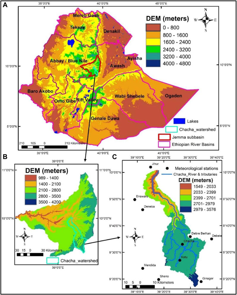
FIGURE 1. Map of the study area: (A) River Basins of Ethiopia; (B) Jemma River Sub-basin; and (C) Exact study area (i.e., the Chacha River Watershed).
The most dominant agroecological class is “Dega” (i.e., humid) which covers about 84.8% of the watershed, whereas the remaining 14% and 1.2% are categorized as “Weyna Dega” (i.e., sub-humid) and “Wurch” (temperate type) agro-ecologic zones. As indicated in Figure 1C, there are about 10 meteorological stations in and near the Chacha Watershed: namely, Chacha, Debre Berhan, Kotu, Debele, Sheno, Ginager, Mendida, Deneba, Enewari, and Jiru. All of them were used for climate analysis of the present study. Based on the climate data of 1986–2019, the mean annual average, minimum and maximum temperatures of the Chacha Watershed are, 15.1°C, 8.5°C, and 20.7°C, respectively with mean annual rainfall ranges from 708–1,226 mm. As shown in Figure 2, the highest average, maximum, and minimum temperatures were recorded in May. The highest monthly rainfall was observed in July and August with 294.12 mm and 289.94 mm per month, respectively. Similarly, based on the streamflow data of 1974–2018, the highest monthly streamflow was detected in July and August with 501.5 m3 and 1,187.8 m3 per second, respectively. Like most parts of Ethiopia, June, July, August, and September are the major rainy seasons in the study watershed, whereas October, November, December, and January are dry seasons. However, February, March, April, and May are minor rainy seasons.
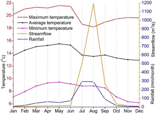
FIGURE 2. Average monthly rainfall, streamflow, and temperature pattern of the Chacha Watershed from 1986-2019, whereas the streamflow was shown from 1970-2014.
2.2 Datasets
2.2.1 Hydro-meteorological data
The hydro-meteorological datasets, such as rainfall, maximum and minimum temperatures for 1986-2019 were obtained from the national meteorological institute of Ethiopia. The climate datasets were used from 10 meteorological stations of the Chacha Watershed: namely, Chacha, Debre Berhan, Kotu, Debele, Sheno, Ginager, Mendida, Deneba, Enewari, and Jiru as indicated in Figure 1C. For the computation of irrigation crop water requirement, CLIMWAT database datasets were used besides the gathered climate data from National Meteorological Institute. The streamflow data from 1974-2018 of the Chacha hydrological gauging stations were obtained from the Ministry of Water Resources and Energy of Ethiopia.
2.2.2 Spatial datasets and GIS files
The various land uses, soils, slopes, road networks, and streamlines GIS files and spatial datasets were obtained from different sources. The chemical properties of the soils, such as pH, organic carbon, available water storage capacity (AWSC), cation exchange capacity (CEC), and electrical conductivity (EC), as well as the physical properties of the soils: namely, soil type, soil drainage, soil depth, and texture classes with a spatial resolution of 250 m, were downloaded from Harmonized World Soil Database (HWSD). For the land use cover change analysis, Landsat 8 Operational Land Imager (OLI) and Thermal Infrared Sensor (TIRS) Level-1 pre-processed data products with path 168 and row 53 were downloaded from the United State Geological Survey (USGS). The pre-processed imagery of the year 2021 with a resolution of 30 × 30 m, which was acquired on March 26, was further processed for land use cover change detection using ArcGIS 10.8. Similarly, the PALSAR Digital Elevation Model (DEM) from the Alaska Satellite Facility Distributed Active Archive Data Center (ASF DAAC) with a resolution of 12.5 m was downloaded from (https://search.asf.alaska.edu/#/). The road network, streamline, and other necessary GIS files were obtained from the Ministry of Water Resources and Energy of Ethiopia.
2.3 Methods
Following the data collected from the different sources, the data analysis was carried out using ArcGIS 10.5, and analytical hierarchy process (AHP). The analysis focused on the determination of the surface irrigation potential, mapping of the selected land evaluation factors, GIS-based analytical hierarchy process for land suitability modeling, determination of the total water requirements of crops, and quantification of the available surface water in the Chacha Watershed. In the ArcGIS, the weighted overlay tool of spatial analysis was used based on AHP of the Multi-Criteria Decision Analysis approach. The factors considered to assess the surface irrigation suitability analysis were Slope, Soil drainage, Soil type, Soil depth, pH, Organic carbon, Road proximity, River proximity, Streamflow, Electrical conductivity of soil (EC), Available water storage capacity (AWSC), Cation exchange capacity (CEC), and Land use/land cover (Hussien et al., 2019; Yohannes and Soromessa, 2018; Yalew et al., 2016; Bagherzadeh and Gholizadeh, 2016). Those factors were selected based on expert’s opinion, literature review, and natural condition of the study area. Raster datasets were reclassified based on the set standards for each parameter as indicated in Table 1. Next pairwise comparison matrix of the AHP was applied to determine the relative significance of the entered factors over each other so as to develop a single indexed value. Using the ArcGIS tool, the reclassified raster of the factors was weighted overlay to generate surface irrigation suitable lands. All the analyzed data were presented in the form of maps, graphs, and tables, and later discussed in a descriptive way.

TABLE 1. Surface irrigation potential classification.
2.3.1 Available surface water
The available surface water in the Chacha Watershed was estimated based on the low-flows recorded in the dry season. The low-flows were computed from the gauged station monthly average discharges from 1974-2018. According to Worqlul et al. (2015), low-flow characteristics were examined using a flow duration curve (FDC) of 90-percentile exceedance probability of available flow (Q90). FDC of 90-percentile exceedance provides the percentage of time monthly discharge was exceeded for the 44-year. The discharge corresponding to the 90% probability of occurrence is termed as a low-flow discharge. The probability of occurrence is the ratio of the rank of the daily flows arranged in descending order divided by the total number of years multiplied by 100. Finally, a FDC graph with percentage of time in the “X” axis against its corresponding flow record in the “Y” axis was plotted. Therefore, the available surface water in the Chacha Watershed is the flow record obtained by drawing a perpendicular line from the 90%-time percentage and extending to the “Y” axis to find the exact value of the Q90. Then, the available surface water was compared with the irrigation water demand of the study watershed computed using the CROPWAT model.
Irrigation water requirement is the depth of the water applied to crops to supplement the water need of crops, and it is the difference between crop water requirement and effective rainfall. The water requirements of the crops grown in the watershed were assessed by CROPWAT. The crop coefficient for different growth stages, maximum root zone depth and yield reduction factors, and crop height values for each crop were adopted from FAO 56. The recommended overall irrigation efficiency for surface irrigation ranges from 45–50%, and the overall irrigation efficiency equals to 45% was used in the present study. To accomplish the study, 44 years (i.e., 1974-2018) of climatic data were collected from the National Meteorological Agency, but the aggregate monthly reference evapotranspiration (ETo) was determined using the CROPWAT software. During the determination of irrigation requirements, months requiring a small amount of irrigation water were classified as the highly suitable for surface irrigation and vice versa.
where: ETC., = Crop evapotranspiration, ETO = Reference crop evapotranspiration, KC = Crop coefficient. The gross irrigation water requirement may be expressed as:
where: GIR = Gross irrigation requirement (mm/day), NIR = Net irrigation requirement (mm/day)
The net irrigation requirement was determined using Eq. 3.
Where: NIR = Net irrigation requirement (mm/day), ETC., = Crop evapotranspiration (mm/day), Pe = Effective rainfall (mm/day)
2.3.2 Surface irrigation influencing factors
Determining land suitability for surface irrigation was conducted based on FAO, (1976) using the following factors, and the summary of the factors were indicated in Tables 1, 2, and Table 3.
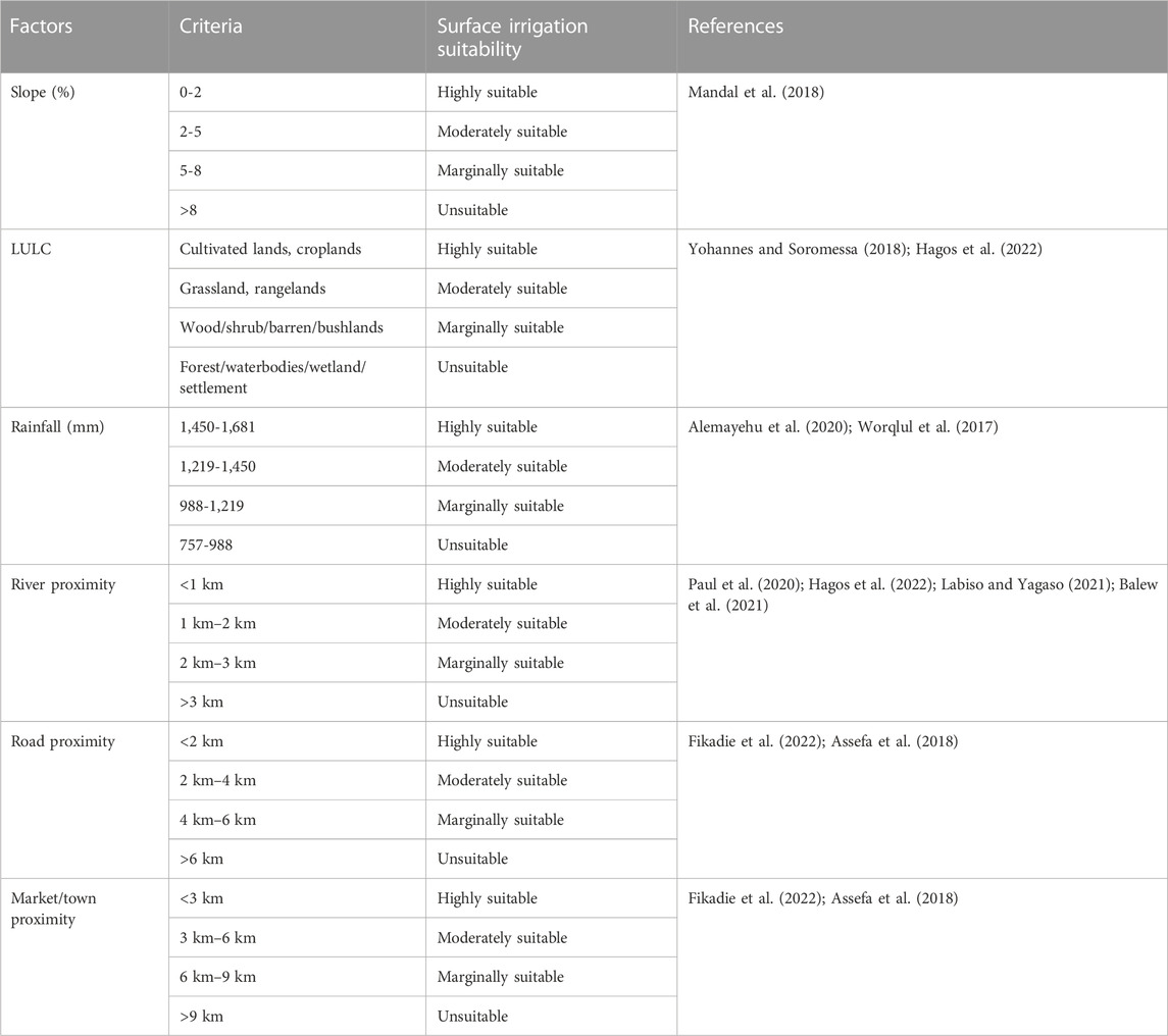
TABLE 2. Assessment of surface irrigation suitability factors.
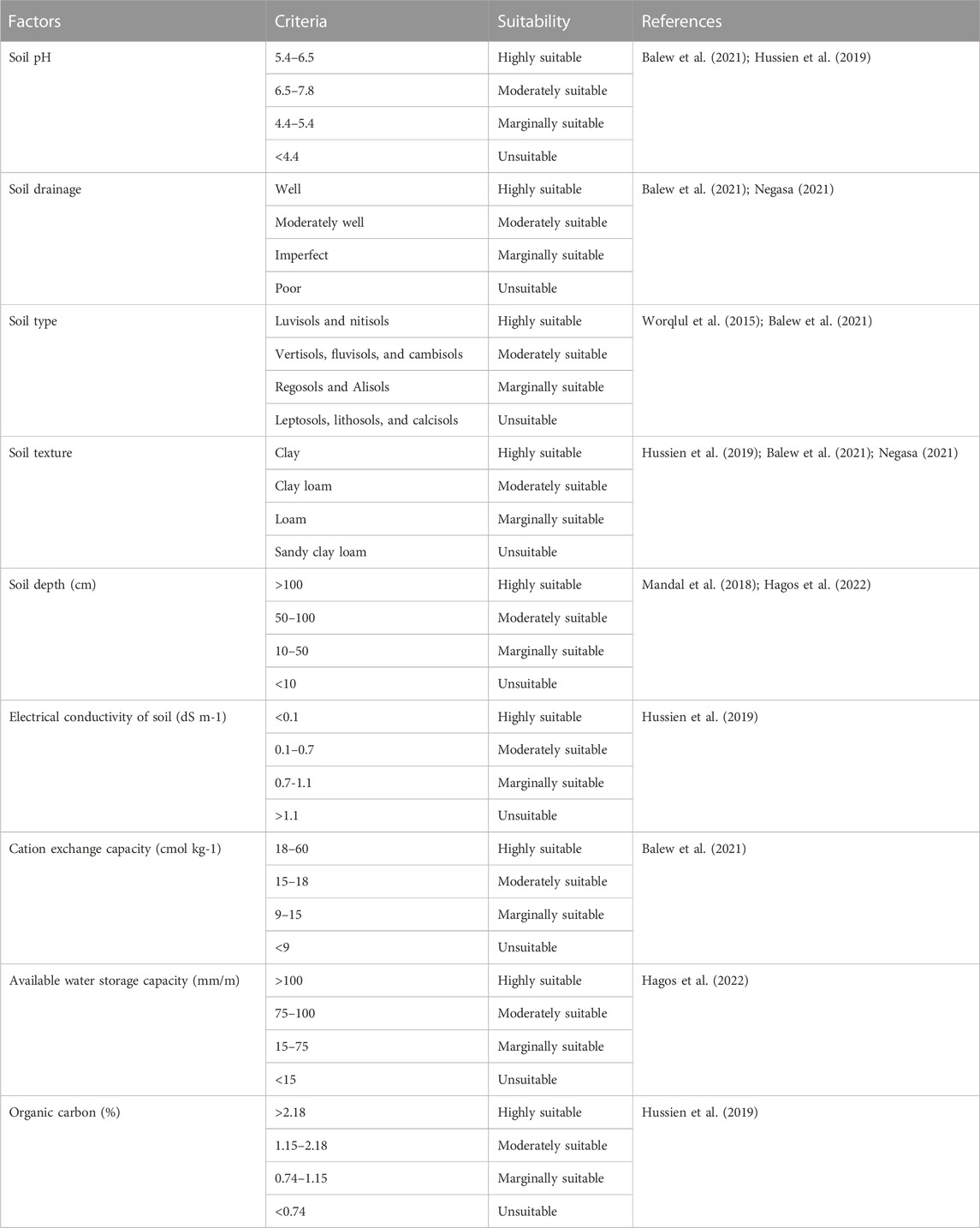
TABLE 3. Assessment of soil related surface irrigation suitability factors.
2.3.2.1 Slope
The slope (i.e., the inclination of the surface) is extracted from the DEM. The slope is one of the most influential factors in land suitability analysis for surface irrigation, which cloud also affect the preparation of the irrigable land, irrigation operation, irrigation efficiency, erosion, land preparation cost, crop type, production costs, and method of irrigation (Hussien et al., 2019; USDIBR, 2003). Based on FAO (1999) standard classes of land suitability for surface irrigation, the slope of the Chacha Watershed was grouped into different classes as followed: slopes less than 2% i.e., horizontal classified as highly suitable, slopes between 2-5% i.e., very flat are classified as moderately suitable, slopes between 5-8% i.e., flat is classified as marginally suitable, and slopes greater than 8% i.e., steep is classified as unsuitable. In surface irrigation, irrigation water flows through gravity so that slopes have a greater impact on surface irrigation suitability (USDIBR, 2003; Yimere and Assefa, 2022). In other words, slope can affect irrigation suitability in terms of land preparation, soil moisture storage, and erosion rate.
2.3.2.2 Land use land cover (LULC)
Land use land cover is one of the many significant parameters in land suitability analysis for surface irrigation (Hagos et al., 2022). This is because LULC helps identify the productivity of an area for irrigation. The land use map of 2021 was generated from the Landsat 8 OLI and TIRS. The major land use classes generated for the Chacha Watershed are: forest land, cultivated land, grazing land, bare land, riverbed, and built-up areas. Based on surface irrigation suitability, cultivated land was classified as very suitable, and grassland that requires land preparation, such as clearing and leveling was classified as moderately suitable for irrigation. However, barren lands that require a higher initial investment for land preparation, were reclassified as marginally suitable. Whereas forests/water bodies/settlements (i.e., built-up areas) were reclassified as unsuitable land use type (Worqlul et al., 2017; Hagos et al., 2022; Yohannes and Soromessa, 2018).
2.3.2.3 River proximity
In Ethiopia, most communities practice their irrigation activities near rivers or lakes. Cultivation lands near the water resources can easily get water for agricultural production and are highly favorable to surface irrigation. River/water resources proximity is one of the main criteria that almost certainly influence the site location of surface irrigation. So, based on streamlines equal distance, river proximity map was generated using a multiple-ring buffer of ArcGIS. The distance to the major River Chacha and its tributaries was computed and categorized into four various classes, in such a way that land areas located within distance up to 1 km from the river are grouped as highly suitable, whereas areas located within 1–2 km distance from the river are classified as moderately suitable for surface irrigation. Areas located within 2–3 km and more than 3 km distance from rivers are denoted as marginally suitable and unsuitable for surface irrigation, respectively (Balew et al., 2021; Labiso and Yagaso, 202; Paul et al., 2020; Hussien et al., 2019).
2.3.2.4 Market/town and road proximity
Irrigation practice requires market and road access to buy agricultural inputs and also sell agricultural production. Moreover, it helps implement several irrigation technologies, and also it is relatively easy to control in case of crop diseases and pests or any other problem occurred. Similar to the river proximity map, the market or road proximity map was generated using a multiple-ring buffer of ArcGIS. The surface irrigation suitability class of market/town proximity was categorized in distances of 3 km, 3–6 km, 6–9 km, and greater than 9 km from the market/town with the suitability range of very suitable, moderately suitable, marginally suitable, and unsuitable, respectively. Likewise, the road proximity map was categorized as very suitable, moderately suitable, marginally suitable, and unsuitable with distances of road less than 2km, 2–4 km, 4–5 km, and greater than 6 km, respectively (Worqlul et al., 2015; Assefa et al., 2018; Fikadie et al., 2022).
2.3.2.5 Rainfall
The available long-term climate data were collected from the NMI of Ethiopia from 1986-2019 and spatially extrapolated using the Inverse Distance Weighting interpolation (IDW) method. The rainfall amount is one of the factors that affect surface irrigation suitability. Areas that have high rainfall depth can have better recharge rates of rivers, streams, and springs which in turn increase the water storage that can be used for surface irrigation. Thus, based on equal intervals, long-term average rainfall areas that have better amount of rainfall were categorized as very suitable (1,450–1,681 mm), moderately suitable (1,219–1,450 mm), marginally suitable (988–1,219 mm), and unsuitable (757–988 mm) for surface irrigation (Worqlul et al., 2017; Alemayehu et al., 2020). Areas that have a high rainfall amount are better for surface irrigation relative to areas that have a low amount of rainfall.
2.3.2.6 Soil type
Soil is a crucial factor for evaluating the suitability of land for sustainable irrigation and agricultural productivity. As shown in Figure 3, the major soil types identified in the Chacha Watershed were Leptosols, Cambisols, Nitisols, Regosols, and Vertisols. However, Vertisols and Cambisols were the two most dominate soil types, which covered about 98% of the study watershed. Based on FAO (1976), Luvisols, and Nitisols were classified as highly suitable, while soil types, such as Leptosols, Lithosols, and Calcisols were categorized as unsuitable for surface irrigation. Vertisols, Fluvisols, and Cambisols were considered moderately suitable, but Regosols and Alisols were categorized as marginally suitable (USDIBR, 2003; Worqlul et al., 2015; Nigussie et al., 2019; Hussien et al., 2019; Balew et al., 2021).
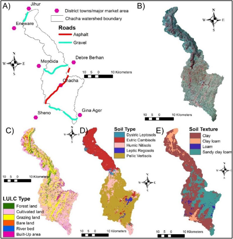
FIGURE 3. (A) Major market centers found in the towns of districts near the Chacha Watershed; (B) False color composite of Landsat 8 Red, Green and Blue that are Band 5, 4 and 3; (C) Land use land cover type; (D) Soil type; and (E) Soil texture.
2.3.2.7 Soil texture
The water movement in the soil and water holding capacity of soil is reliant on the type of soil texture because it governs soil opening space (Balew et al., 2021). Thus, soil texture is one of the main factors affecting surface irrigation suitability. As shown in Figure 3, The major soil texture recognized in the Chacha Watershed is clay, clay loam, sandy clay loam, and loam. For example, clay soil texture covers most parts of the Chacha Watershed as indicated in Figure 3. Clay soil texture has a good property that has better nutrient and moisture content for surface irrigation and is considered a highly suitable class, whereas clay loam, loam, and sandy clay loam are categorized as moderately suitable, marginally suitable, and unsuitable soil texture classes, respectively (Balew et al., 2021; Negasa, 2021).
2.3.2.8 Soil depth
Soil depth is one of the prime factors for evaluating surface irrigation suitability because it affects the water holding capacity and nutrients of the soil (Mandal et al., 2018). The soil water content and crop root depth decrease as the soil depth is shallow that resulting in tough surface irrigation and crop failure, while the reverse is true when the soil depth gets deeper and deeper. Therefore, soil depth is categorized into four classes: highly suitable, moderately suitable, marginally suitable, and unsuitable for surface irrigation when the soil depth is greater than 100 cm, between 100-50 cm, between 50-10 cm, and less than 10 cm, respectively (Hussien et al., 2019; Teshome and Halefom, 2020; Hagos et al., 2022).
2.3.2.9 Soil drainage
Soil drainage is the removal of surplus water from the root zone that minimizes salinity and water logging besides to ventilating the root zone. Thus, well-drained soil allows the normal growth of plants meaning that is very suitable for surface irrigation. It is another vital factor that is required to be evaluated for surface irrigation suitability because it affects the quality, nutrient, and water-holding capacity of the soil. Similarly, soils that are well, moderately well, imperfect, and poorly drained in the Chacha Watershed are grouped as highly suitable, moderately suitable, marginally suitable, and unsuitable for surface irrigation, respectively (Balew et al., 2021; Negasa, 2021).
2.3.2.10 Soil pH
The degree of soil acidity is one of the factors that need to be examined for surface irrigation suitability as it affects crop yield (USDIBR, 2003). A soil pH value less than 4.4 was characterized as acidic which affects crop growth and is unsuitable for surface irrigation, whereas a pH value between 5.4 and 6.5 is considered highly suitable because the soil acidity or alkalinity level is low that has better nutrient availability for most crops to grow. The soil pH values ranging from 6.5 and 7.8 were considered moderately suitable, and if the soil pH values vary between 4.4 and 5.4, the land is considered marginally suitable for surface irrigation as some crops, such as tea and pineapple are tolerant to this high acid or alkaline level (Balew et al., 2021; Hussien et al., 2019).
2.3.2.11 Organic carbon
Soil organic carbon is a measure of soil organic matter as a result of the decomposition of roots, seeds, leaves, crop residuals, and other organic materials (Hussien et al., 2019). Sustaining and enhancing the organic matter of the soil is vital for soil fertility improvement besides to reduction of erosion and increase in aeration, cation exchange capacity, and moisture holding capacity that overall increase agricultural productivity (Balew et al., 2021). Thus, soil organic matter greater than 2.18% is considered highly suitable healthy soil for surface irrigation, whereas soil organic matter less than 0.74% is characterized as unsuitable. Soil organic carbon varies between 1.15–2.18% and 0.74–1.15% are categorized as moderately and marginally suitable, respectively (USDIBR, 2003).
2.3.2.12 Available water storage capacity (AWSC) of soil
The AWSC is the portion of water obtained in the soil that can easily be accessible for plant use. The AWSC estimation method was developed by FAO in 1995, considering topsoil textural class with depth/volume limiting soil phases and spatial datasets are readily available in Harmonized World Soil Database that is expressed in mm/m (Fischer et al., 2010). The availability of water in the soil is highly dependent on soil texture and stratification that finer soils can hold a greater amount of water. Soil textures like clay loam, clay, and silt clay have the ability to hold more water relative to other texture classes (Fischer et al., 2010; Hagos et al., 2022). Overall, soils that have a fine sand fraction, clay, and silt with low infiltration rates can hold a greater amount of water that can be accessible for plants to grow. Accordingly, the AWSC is classified as highly suitable, moderately suitable, marginally suitable, and unsuitable where the AWSC in mm/m greater than 100, between 75-100, between 15-75, and less than 15, respectively (Balew et al., 2021; Hagos et al., 2022).
2.3.2.13 Soil cation exchange capacity (CEC)
Cation exchange capacity means the capability of the soil to hold exchangeable cations, which is fine textured soil with high organic matter and clay content that is a great indicator of soil fertility or productivity (Hussien et al., 2019). Whereas, soils with low exchangeable cations are unable to provide adequate nutrients for plants to grow, which limits productivity and can be costly to improve the exchangeable cation capacity of the soil. In this study, the CEC of soil was also evaluated for surface irrigation suitability. Consequently, soils with CEC of less than 9 centimoles per kg (cmol kg-1) were considered unsuitable as the soil can have limited nutrient and organic carbon, while the soil CEC from 18–60 cmol kg-1 is classified as highly suitable for surface irrigation. Soil CEC that ranges from 9–15 cmol kg-1 and from 15–18 cmol kg-1 were categorized as marginally and moderately suitable for surface irrigation, respectively (Hussien et al., 2019; Balew et al., 2021). Overall, soils with high CEC can have a great capacity of holding nutrients (cations) that increase productivity with less leaching (Hussien et al., 2019).
2.3.2.14 Electrical conductivity of soils (EC)
The EC of soils is a measure of soil salinity/saturation and it is one of the most significant factors that need to be evaluated for surface irrigation potential because salinity limits crop growth or productivity (Hussien et al., 2019). Some crops, such as beets can tolerate salinity, whereas others can be easily injured with low level of salt. Soils with high salt concentration can be toxic for most crops which in turn affect productivity through reduction of water availability and inhibit nutrients uptake. Overall, the EC of soils are categorized as highly suitable, moderately suitable, marginally suitable and unsuitable where the EC deciSiemens per meter (dS m-1) less than 0.1, varies between 0.1-0.7, ranges between 0.7-1.1, and greater than 1.1, respectively (USDIBR, 2003; Fischer et al., 2010).
2.3.3 Analytical hierarchy process (AHP) for factor weighting
In this study, several factors, such as Slope, Soil type, Soil drainage, Soil depth, Soil texture, pH, Organic carbon, Road proximity, River proximity, Market proximity, Streamflow, Available water storage capacity (AWSC), Cation exchange capacity (CEC), Electrical conductivity of soil (EC), and Land use/land cover were used as inputs for AHP multicriteria assessment model to assess the surface irrigation potentials of the Chacha Watershed. The AHP was used to assign weights to each factor based on its level of significance to irrigation suitability. A pair-wise comparison matrix of multi-criteria approach was used to evaluate and determine the factors affecting land suitability for agricultural purpose through a series of judgments based on experts’ points of view (Hussien et al., 2019). A scale of relative importance ranges from a value of 1–9 that used in AHP to indicate whether the two factors are equally important or one is more important than the others (Table 4). A pair-wise comparison of factors was performed and normalized to assign the parameter weight and get eigenvalues. The random consistency index (RI) proposed by Saaty (1980) was applied to check the consistency ratio (CR) that validates the consistency of factors. Consistency index (CI) is calculated as followed:
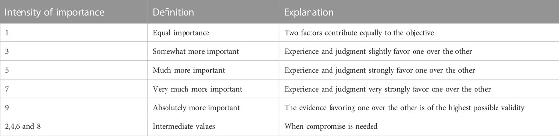
TABLE 4. The fundamental scale for pair-wise comparison matrix (Saaty, 1980).
Where, λmax is the largest eigenvalue of the pairwise comparison matrix and n is the number of classes.
2.3.4 Conceptual framework
To accomplish this study, several datasets were collected from various sources, including soil, satellite image, climatic, digital elevation model, access to infrastructure and river flow data. The general conceptual framework of the present study was shown in Figure 4.
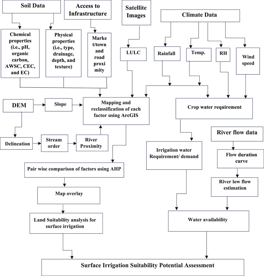
FIGURE 4. General methodology followed to assess and evaluate surface irrigation suitability potentials of the Chacha Watershed.
3 Results and discussion
Several datasets or factors that possibly affect surface irrigation potentials of the study watershed were gathered from different sources. Based on the availability and accessibility of the required data, the surface irrigation potentials of the Chacha Watershed were assessed and evaluated by employing chemical properties of soils (i.e., pH, organic carbon, available water storage capacity (AWSC), cation exchange capacity (CEC), and electrical conductivity (EC)), physical properties of soils (i.e., type, drainage, depth, and texture), slope, proximity of (road, town, and rivers), and land use land cover (LULC). These datasets or factors were analyzed using ArcGIS and AHP. Additionally, the surface water availability was examined and compared with the water requirement of dominant crops grown in the watershed. Thus, examining water and land resources’ suitability and/or availability is essential to determine the surface irrigation potentials of the Chacha Watershed.
3.1 Evaluation of the factors that affect surface irrigation potentials
3.1.1 LULC, slope, rainfall, and proximity to river, road, and market centers
As indicated in the method section (i.e., Table 2), land use land cover (LULC) of the Chacha Watershed was classified into four classes: highly suitable, moderately suitable, marginally suitable, and unsuitable with coverages of 55.44%, 27.96%, 2.49%, and 14.11% of the study watershed, respectively (Table 5). Based on LULC, about 55.44% of the watershed is easily irrigable without any limitation where it is located in the southern, southeastern, and southwestern portions of the watershed. However, the remaining 14.11% (i.e., settlements/forest/water bodies and rivers) of the watershed which is found in the northern and central part were not suitable for surface irrigation (Figure 5A). The results of the present study revealed that agricultural land is found to be highly suitable for surface irrigation, while forest/water bodies/settlement (built-up areas) is grouped as unsuitable. Grass and barren lands were classified as moderately and marginally suitable land covers for surface irrigation (Yohannes and Soromessa, 2018; Hagos et al., 2022). For this study, the surface irrigation suitability classes of the slopes were examined and determined based on FAO (1999) and other succeeding studies conducted in Ethiopia (e.g., Mandal et al., 2018; Girma et al., 2020; Hagos et al., 2022; Yimere and Assefa, 2022). However, there are other studies that used different classes of slopes, i.e., 0–5%, 5–8%, 8–15%, and greater than 15% were highly suitable, moderately suitable, marginally suitable, and unsuitable, respectively (Balew et al., 2021). The findings of the slope’s suitability evaluation indicated that 14.94%, 15.81%, 26.83%, and 42.43% of the Chacha Watershed are highly suitable (i.e., slopes ranging from 0–2%), moderately suitable (slopes ranging from 2–5%), marginally suitable (slopes ranges from 5–8%), and unsuitable (slopes >8%), respectively (Table 5; Figure 5B). On the basis of slope’s evaluation, about 14.94% of the study watershed particularly found in the southwest and central part are surface irrigable without any constraint, whereas 42.43% of the watershed situated in the north and south peripheries are unsuitable for surface irrigation, because of the undulating and mountainous nature of the areas.
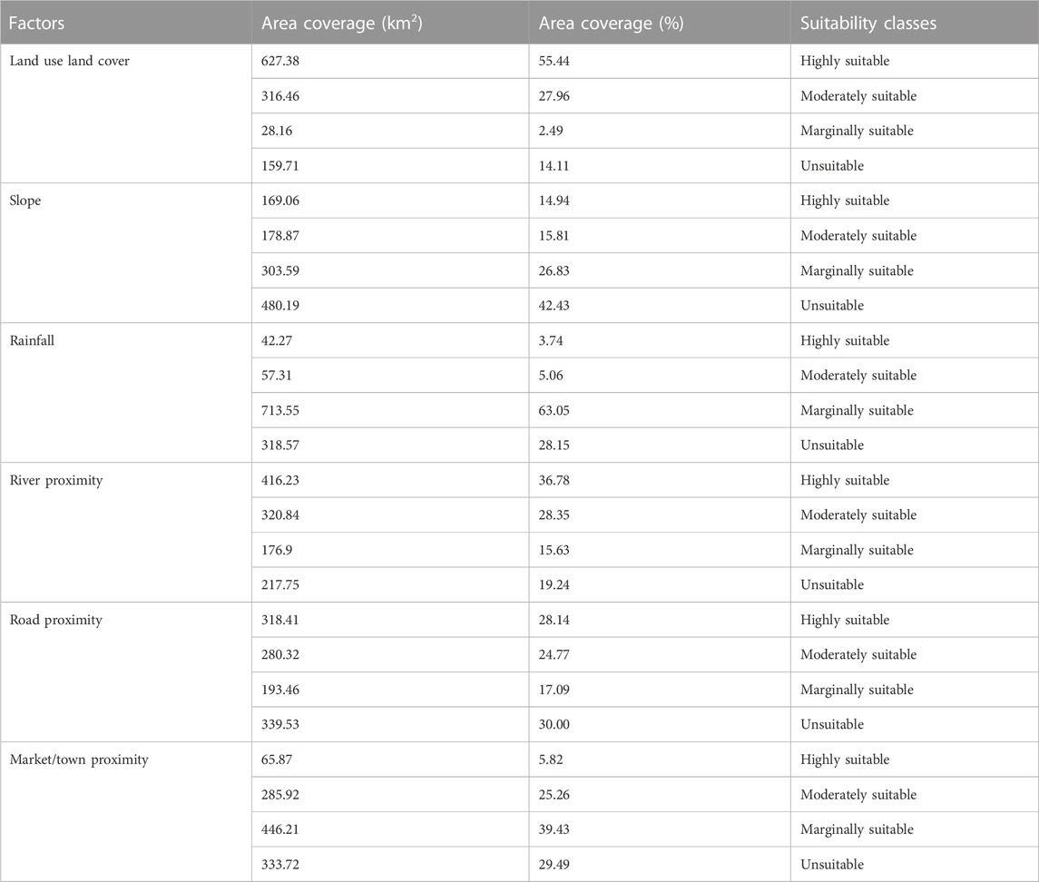
TABLE 5. Suitability analysis of determinant factors for surface irrigation potentials in the Chacha Watershed.
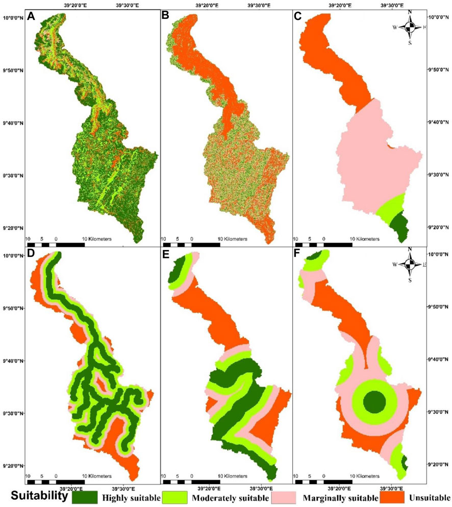
FIGURE 5. Surface irrigation suitability determined based on various factors, including: (A) Land use land cover (LULC); (B) Slope; (C) Rainfall; (D) River proximity; (E) Road proximity; and (F) Market/town proximity.
The rainfall evaluation result indicated that 3.74% of the watershed in the southern periphery is highly suitable for surface irrigation, whose annual average rainfall ranging from 1,450 to 1,681 mm, whereas 28.15% of the watershed in the northern part is currently unsuitable because its annual average rainfall is lower (i.e., ranging from 757–988 mm). About 5.06% of the watershed is moderately suitable and the remaining 63.05% of the watershed situated in the central part is marginally suitable (Table 5; Figure 5C). Similar to this study, previous studies suggested that when the long-term average rainfall of the study area was considered and classified into equal interval classes, high rainfall area is highly suitable for surface irrigation while a lower rainfall area is unsuitable (Worqlul et al., 2017; Alemayehu et al., 2020). Similar to the elevation pattern of the study watershed, the rainfall trend generally decreases as one goes from south to north.
The river/water source distance to the land is another important factor that affects surface irrigation potentials of a given watershed. In the present study, buffer area from the river was created within 1 km, 1–2 km, 2–3 km, and greater than 3 km, which is considered highly suitable, moderately suitable, marginally suitable, and unsuitable, respectively. The findings revealed that about 36.78% of the study watershed which is found near to the water source is categorized as highly suitable, while 19.24% is grouped as currently unsuitable. The remaining 28.35% and 19.24% of the watershed were classified as moderately and marginally suitable (Table 5; Figure 5D). In the present study, the river proximity distance was classified based on (Paul et al., 2020; Balew et al., 2021; Labiso and Yagaso, 2021), while other studies used various distances to classify the surface irrigation suitability (e.g., Hussien et al., 2019; Fikadie et al., 2022; Hagos et al., 2022).
Following Fikadie et al. (2022) and Assefa et al. (2018), the road and town proximity analysis were classified for the present study. The findings of the irrigable land proximity to the road analysis indicated that about 28.14% of the watershed is highly suitable, which is found within 2 km of gravel or asphalt roads. On the other hand, the results revealed that about 24.77% of the study watershed is moderately suitable, which is found between 2-4 km. Regarding road proximity, about 17.1% of the watershed is marginally suitable, whereas 30% of the land is far and unsuitable, i.e., located greater than 6 km from roads (Table 5; Figure 5E). Most of the areas in the study watershed are far from towns/market centers where about 5.82% of the watershed is highly suitable, i.e., found within 3 km of towns. The largest part of the watershed, about 39.43%, is considered marginally suitable, i.e., found within 6–9 km from the market centers. Based on access to markets, about 25.26% of the land is moderately suitable, where located between 3-6km, whereas about 29.49% of the watershed is relatively unsuitable, because it is found far from 9 km from the market centers (Table 5; Figure 5F).
3.1.2 Soil physical and chemical properties
In the present study, the soil pH classification was generated following Balew et al. (2021) and Hussien et al. (2019). Chemical and physical soil characteristics, such as pH, drainage, type, texture, depth, electrical conductivity (EC), cation exchange capacity (CEC), available water storage capacity (AWSC), and organic carbon (OC) of the soils were analyzed to determine the surface irrigation potentials of Chacha Watershed. As illustrated in Table 6; Figure 6A, the soil pH evaluation result revealed that the largest area, comprising about 56.7%, in the south-central part of the watershed is highly suitable for surface irrigation. This is because the soils pH value ranges from 5.4 to 6.5, while about 4.9% of the watershed is unsuitable because the soil pH value is < 4.4. The moderately suitable lands are about 27.2% whose soil pH varies from 6.5 to 7.8, and the remaining 11.2% of the watershed which is situated in the northern part was considered marginally suitable for surface irrigation because the soil pH value ranges from 4.4 to 5.4.
TABLE 6. Suitability analysis of the physical and chemical properties of the soils to determine the surface irrigation potentials of the Chacha Watershed.
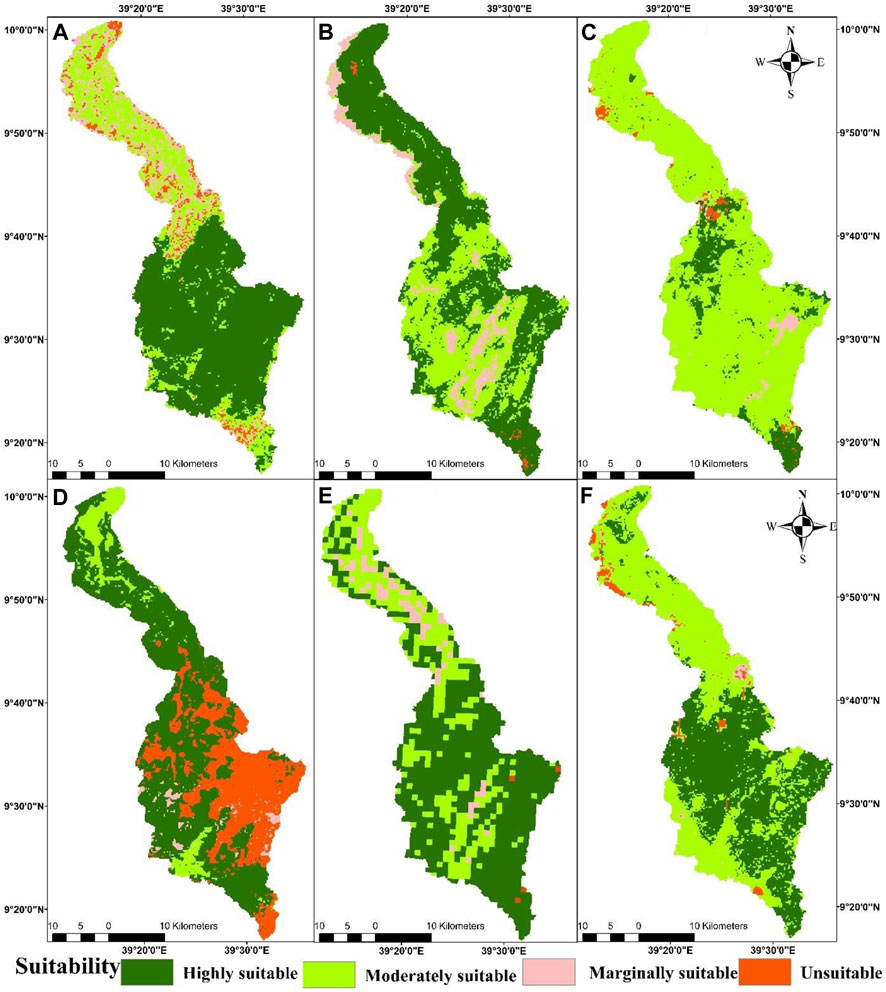
FIGURE 6. Surface irrigation suitability determined based on various factors, including: (A) Soil pH; (B) Soil drainage; (C) Soil type; (D) Soil texture; (E) Soil depth; and (F) Electrical conductivity of Soil (EC).
Based on the soil drainage characteristics of the soil, the largest part of the watershed is well-drained and highly suitable for surface irrigation covering an area of 55.4% (626.4 km 2), whereas 35.5% of the land is moderately suitable, i.e., the soil is moderately well-drained (Table 6; Figure 6B). In reference to Negasa, (2021), the marginally suitable and unsuitable that are imperfectly and poorly drained soil classes cover 8.6 and 0.5% of the study watershed, respectively.
Following USDIBR (2003), Worqlul et al. (2015), Hussien et al. (2019), Balew et al. (2021), and Negasa (2021), the soil types/textures/depths were classified for the Chacha Watershed. The soil type analysis indicated that about 11.8% (134 km2) of the watershed is highly suitable for surface irrigation because the soil type is categorized as Nitisols. The most dominant soil types in the watershed were Vertisols, and Cambisols which were categorized as moderately suitable for surface irrigation practice, i.e., covering about 84.4% (954.8 km2) of the land. Similarly, 2.0% and 1.9% of the watershed were classified as Regosols and Leptosols, where they were found to be marginally suitable and unsuitable for surface irrigation, respectively. The soil texture analysis indicated that the largest area (covering about 58.7% of the total watershed) is mostly located in the northern part, and is highly suitable for irrigation practice because the soil texture is clay. On the other hand, about 30.5% of the watershed which is mostly found in the southwest was considered unsuitable for surface irrigation because the soil texture is sandy clay loam. About 8.56 and 2.2% of the watershed were categorized as moderately suitable and marginally suitable because their soil texture are clay loam and loam, respectively (Table 6; Figure 6D). The soil depth of the Chacha Watershed was generally found within a range of 1–150 cm, and most of the area particularly in the south is highly suitable for surface irrigation because the depth was greater than 100 cm and their area coverage was about 63.3% (716 km2) of the watershed, while unsuitable areas are located in the north and covered about 0.4% (4.7 km2) with a soil depth less than 10 cm. The soil depth ranging from 50 to 100 cm and from 10 to 50 cm was also classified as moderately suitable and marginally suitable with their respective area coverage of 30.5% (345 km2) and 5.8% (66 km2) of the watershed, respectively (Table 6; Figure 6E).
Following USDIBR (2003), Fischer et al. (2010), and Hussien et al. (2019), the Electrical Conductivity (EC) of the soils was assessed and evaluated to determine the surface irrigation potentials of the Chacha Watershed. The findings revealed that the EC less than 0.1 dS m-1 is highly suitable for the surface irrigation practice, which covers 46.77% (529.32 km2) of the study watershed. The soil EC values ranging from 0.1-0.7, varying between 0.7-1.1, and greater than 1.1 dS m-1were classified as moderately suitable, marginally suitable, and unsuitable, which covered 50.02%, 0.82%, and 2.39% of the study watershed, respectively. However, a few studies simply classified the soil EC into two classes: i.e., suitable and unsuitable using less than or greater than 0.2 as the threshold value (Sebnie et al., 2020; Balew et al., 2021). Using the soil EC, almost the entire study watershed falls under the category of highly and moderately suitable areas for surface irrigation with a coverage of 96.79% (1,095.44 km2) (Table 6; Figure 6F).
The findings of the soil cation exchange capacity (CEC) revealed that highly suitable areas for surface irrigation in the study watershed were 39.78% with CEC values of 18–60 cmol kg-1. Based on CEC, the largest part of the study watershed falls under a moderately suitable category with an area of 46.18%, where its CEC values range from 15–18 cmol kg-1. The marginally suitable land was about 12.04% (CEC values vary from 9 to 15 cmol kg-1), but the unsuitable land was about 2% with CEC values of less than 9 cmol kg-1. Similar to the results of the other characteristics of the soils, the highly and the moderately suitable CEC were located in the southern part of the study watershed, whereas the unsuitable parts were found in the southern periphery (Table 6; Figure 7A).
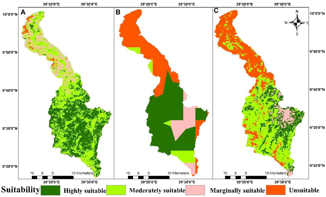
FIGURE 7. Surface irrigation suitability determined based on various factors, including: (A) Cation exchange capacity (CEC); (B) Available water storage capacity (AWSC; and (C) Organic carbon.
Following USDIBR (2003) and Hagos et al. (2022), the available water storage capacity (AWSC) of the soils in the Chacha Watershed was categorized into four classes. The results showed that highly suitable (AWSC >100 mm/m), moderately suitable (AWSC between 75–100 mm/m), marginally suitable (AWSC between 15–75 mm/m), and unsuitable (AWSC <15 mm/m), with area coverage of 48.52%, 7.24%, 11.88%, and 32.35%, respectively. The higher organic carbon which is greater than 2.18 contributed an area of 18.34% (207.56 km2), which is highly suitable for surface irrigation. However, where the organic carbon varies between 1.15-2.18 is moderately suitable, and covering an area of 43.79% (495.62 km2) of the study watershed. About 6.32% (71.54 km2) of the land in the Chacha Watershed was found to be marginally suitable because its organic carbon ranges between 0.74-1.15; however, the remaining 31.55% (357 km2) was found to be unsuitable for surface irrigation practice. The findings further revealed that both highly and moderately suitable lands were located in the southern part of the study watershed, whereas the unsuitable lands were observed in the northern part (Table 6; Figure 7C).
3.2 Surface water available and crop water requirement
Based on the 90-percentile exceedance probability, flow duration curves (FDC) of long-term monthly average streamflow (i.e., 1974-2018) of the Chacha River were used to determine the minimum available surface water resource in the dry season that can be advantageous for implementing surface irrigation. The monthly logarithmic FDC plot versus the exceedance probability of the Chacha River is presented in Figure 8. The steep gradient of the FDC indicated that the streamflow of the Chacha River is highly variable. Based on the 90-percentile FDC, the overall long-term monthly minimum available streamflow of the Chacha River is estimated to be 0.087 m3/s (87 L/s), and using 80-percentile, the minimum available streamflow of the Chacha River was 12.1 m3/s (12,100 L/s). The overall monthly 80 and 90 percentile exceedance probability and monthly average streamflow were shown in Table 7. The monthly low water availability was observed in January, February, March, April, and May, whereas the highest (i.e., an average monthly of 1,187.78 m3/s) was detected in August (i.e., during the pick rainy season) (Table 7).
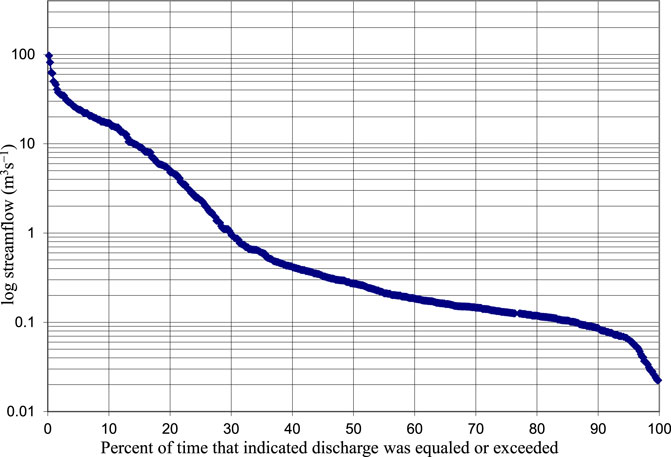
FIGURE 8. Flow duration curve (FDC) of the Chacha River gauging station.
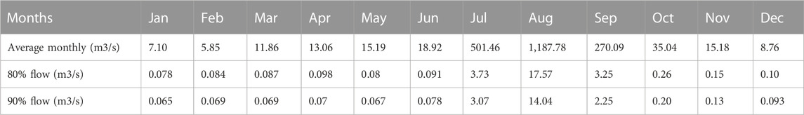
TABLE 7. Average monthly streamflow and monthly flow duration curve analysis using 80 and 90% probabilities.
For the present study, the most common dominant crops in the Chacha Watershed were selected. Those crops were Wheat, Onion, Cabbage, Barley, Potato, and Pulses. The net and gross irrigation crop water requirement was computed using the CROPWAT8.0 model. Subsequently, based on the result of the CROPWAT8.0 model, the total sum of net irrigation requirement (NIR) is 1782 mm for the entire growing season. And, for a hectare of land, the total average crop requirement is about 7 litter per second. Based on the irrigation efficiency of 45%, the total gross irrigation water requirement (GWR) of those crops was 3,960 mm. The growing season NIR of each crop type, such as pulse, potato, barley, wheat, cabbage, and onion were 266.7 mm, 263.5 mm, 345.2 mm, 374.4 mm, 309.7 mm, and 222.5 mm, respectively. Accordingly, the GIWR of pulse, potato, barley, wheat, cabbage, and onion corresponds to 592.7 mm, 585.6 mm, 767.1 mm, 832 mm, 688.2 mm, and 494.4 mm.
3.3 Analytical hierarchy process (AHP)
In order to get the overall surface irrigation suitability of the Chacha Watershed, about 15 factors were weighted and overlaid for this study. In particular, it was done to undertake multicriteria evaluation through the application of AHP methods using pairwise comparison of each suitability factor (Saaty, 1977). Nine out of 15 factors were soil-related suitability factors, such as type, drainage, texture, depth, pH, organic carbon (OC), available water storage capacity (AWSC), cation exchange capacity (CEC), and electrical conductivity (EC). The pairwise comparison of all soil-related suitability factors was conducted independently of other factors to generate one soil-based surface irrigation suitability map (Figure 9A). After the pairwise comparison of all the nine soil-related factors, one raster file called all soil-related suitability factors was obtained. Then, the remaining non-soil-related suitability factors included for this study were: slope, road proximity, town/market proximity, river (water sources) proximity, rainfall, and land use land cover (LULC). The one raster file called all the soil-related factors were further processed, weighted, and overlaid to get the final overall surface irrigation potential suitability of the Chacha Watershed. The relative significance or (pairwise comparison) weighting of the factors was carried out based on experts’ opinions, field observations, focal group discussions, and related literature reviews (Hussien et al., 2019; Balew et al., 2021; Hagos et al., 2022; Yimere and Assefa, 2022). Given the multi-dimensional nature of issues, knowledge, and experience of different stakeholders, including researchers, local authorities, and local farmers, it needs to be mobilized when addressing issues relating to multi-criteria analysis.
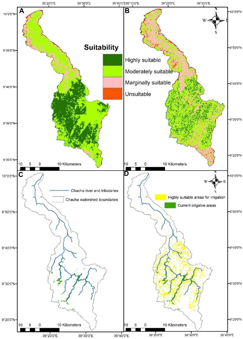
FIGURE 9. (A) Soil-related factors-based surface irrigation suitability map; (B) Overall surface irrigation suitability map, including all the 15 factors; (C) Existing irrigation area; and (D) Current irrigated area overlaid with highly suitable potential areas.
3.3.1 Soil-related factors
Based on the soil-related pairwise comparison and normalized factors as indicated in Tables 8 and 9, the weighted influence of available water storage capacity (AWSC), electrical conductivity (EC), texture, depth, drainage, cation exchange capacity (CEC), organic carbon (OC), pH, and soil type in descending order were 22.7%, 17.3%, 14.1%, 12.8%, 9.2%, 9.4%, 6.1%, 4.5%, and 4.0%, respectively. Subsequently, a soil-related factors-based surface irrigation suitability map was generated using the weighted overlay method under the GIS tool (Figure 9A). The consistency of the pairwise comparison matrix was assessed and evaluated using a Consistency Ratio (CR), where should be less than 0.1 to be consistent, but the CR result of this study was 0.02, which was reasonably consistent and acceptable.
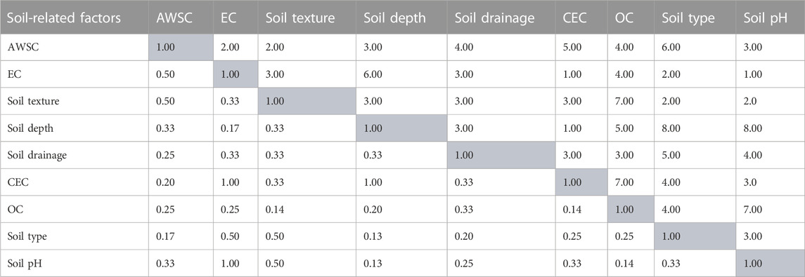
TABLE 8. Pair-wise comparison matrix/comparative importance of the soil-related factors considered to determine the surface irrigation potentials of the Chacha Watershed.
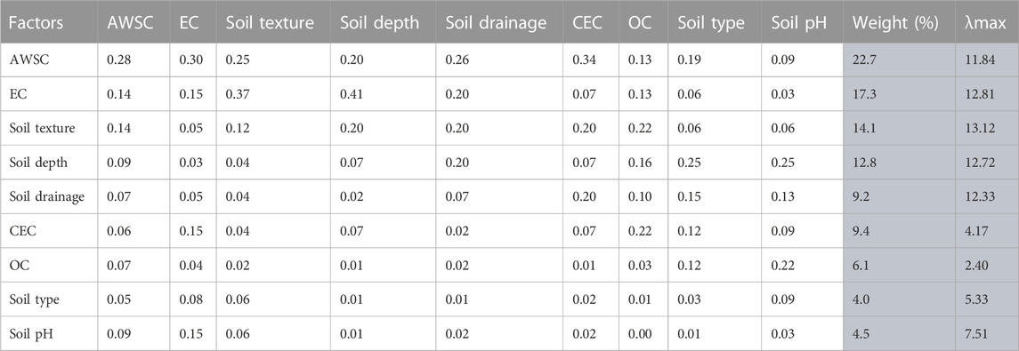
TABLE 9. Standardized pair-wise comparison and weight of the soil-related factors considered to determine the surface irrigation potentials of the Chacha Watershed.
Overall, the nine soil-related factors revealed that about 34.07% of the study watershed (385.61 km2) was highly suitable, 53.85% (609.38 km2) was moderately suitable, 10.64% (120.39 km2) was marginally suitable, while the rest 1.44% (16.32 km2) was unsuitable for surface irrigation potential (Figure 9A). Based on the soil-related factors, most areas of the study watershed were highly and moderately suitable for surface irrigation.
3.3.2 All factors
Tables 10 and 11 showed the pair-wise comparison matrix and weighted influence of several factors, including all the soil factors (i.e., AWSC, EC, texture, depth, drainage, CEC, OC, pH, and soil type), LULC, slope, rainfall, proximities to rivers, market centers/towns, and roads. The final surface irrigation suitability map was generated based on the equation shown below, and the weighted influence of all the entered factors were shown as followed:

TABLE 10. Pair-wise comparison matrix of all the factors considered to determine the surface irrigation potentials of the Chacha Watershed.
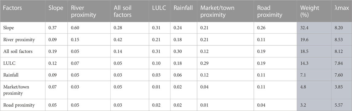
TABLE 11. Standardized pair-wise comparison and weight of all the factors considered to determine the surface irrigation potentials of the Chacha Watershed.
Overall surface irrigation suitability map (Figure 9B) = 32.4×Slope +19.6×River proximity +18.5×All the soil factors (i.e., AWSC, EC, texture, depth, drainage, CEC, OC, Soil type, pH) +14.3×LULC +7.1×Rainfall +4.8×Market/town proximity+3.2×Road proximity. The reliability of pair-wise comparisons was also assessed using the consistency ratio index and the CR of this result was 0.01, which was reasonably consistent and acceptable to weigh the factors to assess and determine the surface irrigation potential suitability of the Chacha Watershed.
The overall assessment result revealed that the largest area (i.e., about 51.6% or 58,357.4 ha) of the study watershed located in the central part near the Chacha town, is moderately suitable for surface irrigation, but 11.8% (13,336.5 ha) of the study watershed is highly suitable to practice surface irrigation (Table 12; Figure 9B). However, about 33.2% (37,588.1 ha) of the study watershed is marginally suitable for surface irrigation. The remaining 3.4% (3,887.9 ha) of the study watershed located in the North and South peripheries were unsuitable for surface irrigation. Given the highly suitable surface irrigation area alone (i.e.,13,336.5 ha) compared to the currently irrigated land (i.e., 2,159.8 ha), the difference is 11,176.7 ha, implying that there is a huge highly suitable surface irrigation potential in the Chacha Watershed.
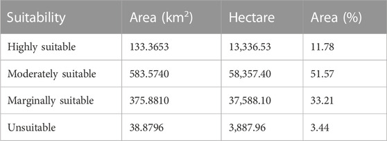
TABLE 12. Overall surface irrigation suitability of the Chacha Watershed.
Based on the CROPWAT output, the total crop water requirement for the growing season/dry season (i.e., January, February, March, April, and May) for the selected crops was about 7 L/s per hectare of land. Moreover, using FDC, the 90-percentile minimum available streamflow of the Chacha River is about 87 L/s. Therefore, the 90-percentile available water flow in the five dry months (i.e., Jan-may) was divided by the total crop water requirement so as to get the surface irrigation potentials of the study watershed. Based on the minimum available flow, the 928-ha land can be irrigable. Given an average watering interval of 10 days, it is possible to irrigate a total of 9,280 ha of land in the Chacha Watershed without any water deficiency. The current irrigated land is about 2,159.8 ha, meaning that the minimum flow can expand the remaining 7,120.2 ha which is currently not irrigated without any limitation. In other words, there is 7,120.2 ha of land available for surface irrigation practice which can serve as a backup to further improve the livelihoods of the local people and thereby ensure food security in the study watershed. Given the highly suitable areas for surface irrigation (i.e., 13,336.5 ha) and the minimum available water flow in the study watershed, there is 12,416.5 ha of land available for surface irrigation, but with a slight limitation of water availability. As far as land suitability is concerned, it is possible to develop the entire 13,336.5 ha of land for surface irrigation practice provided that slight water storage infrastructure (e.g., building small-scale dam) is built along the banks of the Chacha River. This is because the minimum water flow during the dry season is not sufficient to practice surface irrigation in all of the highly suitable areas of the study watershed.
4 Conclusion
Intensive irrigation practice is a significant investment for a country, such as Ethiopia whose economy is highly dependent on rainfed agriculture, which is susceptible to climate change/variability. In this study, the surface irrigation potentials of the Chacha Watershed were assessed and evaluated by applying GIS technique and multicriteria analysis of AHP. The findings of the present study on water availability and land suitability assessment will support policy- and decision-makers, irrigation agronomists, hydrologists, foresters, and land use planners while developing surface irrigation projects in the Chacha Watershed. In doing so, this study considered and accommodated about 15 surface irrigation influencing factors: namely, soil type, drainage, texture, depth, pH, organic carbon (OC), available water storage capacity (AWSC), cation exchange capacity (CEC), electrical conductivity (EC), slope, road proximity, town/market proximity, river (water sources) proximity, rainfall, and land use land cover (LULC). A raster dataset of surface irrigation influencing factors was analyzed and prepared using GIS classifying into four irrigation suitability categories (i.e., highly suitable, moderately suitable, marginally suitable, and unsuitable). Pair-wise comparison matrix and weighted overlay of those factors were carried out using GIS-based AHP following the scale developed by Saaty (1977) to generate the surface irrigation suitability map of the Chacha Watershed. The result of the pair-wise comparison revealed that slope, river proximity, all soil factors, LULC, rainfall, town proximity, and road proximity were found to be the determinant factors of surface irrigation in the study watershed with a weighted influence of 32.4%, 19.6%, 18.5%, 14.3%, 7.1%, 4.8%, and 3.2%, respectively. The over-suitability assessment indicated that 13,336.53 ha (11.78%) of the land in the study watershed was highly suitable for surface irrigation practice, while only 3,887.96 ha (3.44%) of the land was unsuitable for surface irrigation. The largest part (i.e., 58,357.40 ha or 51.57%) of the study watershed was found to be moderately suitable for surface irrigation; however, 37,588.10 ha (33.21%) of the study watershed was marginally suitable.
Based on the dominant crops grown in the study watershed, the crop water requirement was computed using the CROPWAT and the total growing season crop water requirement was estimated to be 1782 mm or 7 L/s per hectare of land. Moreover, based on the FDC of the 90-percentile exceedance probability, the minimum available water flow of the Chacha River was estimated to be 0.087 m3/s (87 L/s). This minimum available water flow can irrigate 9,280 ha of land without water shortage with an average of 10-days watering interval while applying surface irrigation in the study watershed. However, the current irrigated area was estimated at 2,159.83 ha indicating that the surface irrigation practice was quite limited in the study watershed, suggesting that there are more irrigable lands whose area is close to 7,120.17 ha which can be included in surface irrigation projects without any constraint. Furthermore, through the development of properly planned water storage infrastructure (e.g., building small-scale dam) across the Chacha River, more water can be collected during the rainy season. Consequently, it increases the availability of water for surface irrigation in the dry season. In doing so, it is possible to implement surface irrigation over the entire highly suitable areas (i.e., 13,336.53 ha of irrigable land) found in the study watershed. The findings of the present study revealed that the existing irrigation practice in the Chacha Watershed is quite limited. In contrast, water availability and land suitability are high and promising in the study watershed. Thus, the Ethiopian government and/or NGOs should plan to construct irrigation projects (e.g., including small-scale dam) in the study watershed. Moreover, the active engagement of smallholder farmers in the development of surface irrigation projects should be encouraged in the study watershed. In return, the irrigation practices to be implemented in the study watershed helps to boost up agricultural production, and also improve the livelihoods of the local people and thereby ensure food security. Most importantly, this study is crucial because it provides vital scientific knowledge and insights on the existing surface irrigation potentials and land suitability of the Chacha Watershed for government officials and communities in the area.
5 Limitation of the study and recommendation
For the future water quality assessment and hydrological analysis is vital for Chacha watershed. The meteorological and hydrological gauging stations are sparse in the Chacha river watershed; thus, increasing the density of meteorological stations would be helpful for future water resources evaluation and monitoring in the watershed. There was also a lack of ground truth data to verify the irrigation suitability in most of the areas that the topography is rugged. Further investigation of surface and ground water-based irrigation potential is crucial including several other factors that influence the irrigation potential.
Data availability statement
The original contributions presented in the study are included in the article/Supplementary Materials, further inquiries can be directed to the corresponding author.
Author contributions
YG: process and analysis the data, data interpretation, and drafted the first version of the manuscript. AG: write the first draft of the method and revise the manuscript. EL: revised the paper and amended the manuscript. FT: revised the paper and amended the manuscript. ST: revised the paper and amended the manuscript.
Acknowledgments
We greatly recognize groups producing Harmonized World Soil Database (HWSD), and the United States Geological Survey (USGS). We also acknowledge the Ethiopian National Meteorology Institute and Ministry of Water Resources and Energy for giving us the observed meteorological and hydrological datasets.
Conflict of interest
The authors declare that the research was conducted in the absence of any commercial or financial relationships that could be construed as a potential conflict of interest.
Publisher’s note
All claims expressed in this article are solely those of the authors and do not necessarily represent those of their affiliated organizations, or those of the publisher, the editors and the reviewers. Any product that may be evaluated in this article, or claim that may be made by its manufacturer, is not guaranteed or endorsed by the publisher.
References
Alemayehu, S., Ayana, E. K., Dile, Y. T., Demissie, T., Yimam, Y., Girvetz, E., et al. (2020). Evaluating land suitability and potential climate change impacts on alfalfa (Medicago sativa) production in Ethiopia. Atmosphere 11 (10), 1124. doi:10.3390/atmos11101124
Alemu, Z. G., Oosthuizen, K., and Van Schalkwyk, H. D. (2003). Contribution of agriculture in the Ethiopian economy: A time-varying parameter approach. Agrekon 42 (1), 29–48. doi:10.1080/03031853.2003.9523608
Asresie, A., and Zemedu, L. (2015). The contribution of livestock sector in Ethiopian economy. A Rev. Adv. Life Sci. Technol. 29, 2224–7181. https://www.iiste.org/Journals/index.php/ALST/article/viewFile/19767/20040.
Assefa, T., Jha, M., Reyes, M., Srinivasan, R., and Worqlul, A. W. (2018). Assessment of suitable areas for home gardens for irrigation potential, water availability, and water-lifting technologies. Water 10 (4), 495. doi:10.3390/w10040495
Awulachew, S. B. (2019). Irrigation potential in Ethiopia: Constraints and opportunities for enhancing the system. Gates Open Res. 3 (22), 22. doi:10.21955/gatesopenres.1114943.1
Awulachew, S. B., Yilma, A. D., Loulseged, M., Loiskandl, W., Ayana, M., and Alamirew, T. (2007). Water resources and irrigation development in Ethiopia. Colombo, Sri Lanka: International Water Management Institute. 78p. (IWMI Working Paper 123).
Bagherzadeh, A., and Gholizadeh, A. (2016). Modeling land suitability evaluation for wheat production by parametric and TOPSIS approaches using GIS, northeast of Iran. Model. Earth Syst. Environ. 2 (3), 126–211. doi:10.1007/s40808-016-0177-8
Balew, A., Nega, W., Legese, B., and Semaw, F. (2021). Suitable potential land evaluation for surface water irrigation using remote sensing and GIS–MCE in the case of rib–gumara watershed, Ethiopia. J. Indian Soc. Remote Sens. 49 (9), 2273–2290. doi:10.1007/s12524-021-01383-w
Dawit, M., Olika, B. D., Muluneh, F. B., Leta, O. T., and Dinka, M. O. (2020). Assessment of surface irrigation potential of the dhidhessa river basin, Ethiopia. Hydrology 7 (3), 68. doi:10.3390/hydrology7030068
Eshete, D. G., Sinshaw, B. G., and Legese, K. G. (2020). Critical review on improving irrigation water use efficiency: Advances, challenges, and opportunities in the Ethiopia context. Water-Energy Nexus 3, 143–154. doi:10.1016/j.wen.2020.09.001
FAO (1976). “A framework for land evaluation,” in Food and agriculture organisation of the united nations (Wageningen, Netherlands: International Institute for Land Reclamation and Improvement).
FAO (1999). The State of Food and Agriculture 1999: Hunger Declining, But Unevenly. Available at: http://www.fao.org/forestry/FO/SOFO/SOFO99/sofo99-e.stm.
Fikadie, F. T., Wubneh, M. A., Kifelew, M. S., and Sinshaw, B. G. (2022). Assessment of surface irrigation potential and crop water requirement: The case of megech watershed, upper Blue Nile Basin, Ethiopia. Sustain. Water Resour. Manag. 8 (4), 92–20. doi:10.1007/s40899-022-00690-5
Fischer, G., Velthuizen, H. V., Hizsnyik, E., and Wiberg, D. (2010). Potentially obtainable yields in the semi-arid tropics. Availabe at: http://oar.icrisat.org/198/.
Girma, R., Gebre, E., and Tadesse, T. (2020). Land suitability evaluation for surface irrigation using spatial information technology in Omo-Gibe River basin, Southern Ethiopia. Irrigation Drainage Syst. Eng. 9 (5). doi:10.37421/idse.2020.9.245
Hagos, F., Makombe, G., Namara, R. E., and Awulachew, S. B. (2009). Importance of irrigated agriculture to the Ethiopian economy: Capturing the direct net benefits of irrigation (Vol. 128). Availabe at: https://www.iwmi.cgiar.org/Publications/IWMI_Research_Reports/PDF/PUB128/RR128.pdf.
Hagos, Y. G., Mengie, M. A., Andualem, T. G., Yibeltal, M., Linh, N. T. T., Tenagashaw, D. Y., et al. (2022). Land suitability assessment for surface irrigation development at Ethiopian highlands using geospatial technology. Appl. Water Sci. 12 (5), 98–11. doi:10.1007/s13201-022-01618-2
Hussien, K., Woldu, G., and Birhanu, S. (2019). A GIS-based multi-criteria land suitability analysis for surface irrigation along the Erer Watershed, Eastern Hararghe Zone, Ethiopia. East Afr. J. Sci. 13 (2), 169–184.
Kassa, M., and Andualem, T. G. (2020). Review of irrigation practice in Ethiopia, lessons from Israel. Availabe at: https://www.hilarispublisher.com/open-access/review-of-irrigation-practice-in-ethiopia-lessons-from-israel-29329.html.
Labiso, T. T., and Yagaso, Z. S. (2021). Land suitability analysis for surface irrigation in Humbo woreda, wolaita zone, Southern Ethiopia: Land suitability analysis. EQA-International J. Environ. Qual. 44, 32–43. doi:10.6092/issn.2281-4485/12727
Leta, M. K. (2020). Land suitability assessment of surface irrigation potential in gilgel gibe, omo gibe basin, Ethiopia. J. Water Sci. Environ. Technol. 5 (01). https://revues.imist.ma/index.php/JOWSET/article/view/17491.
Mandal, B., Dolui, G., and Satpathy, S. (2018). Land suitability assessment for potential surface irrigation of river catchment for irrigation development in Kansai watershed, Purulia, West Bengal, India. Sustain. Water Resour. Manag. 4 (4), 699–714. doi:10.1007/s40899-017-0155-y
Mekonen, B. M., Gelagle, D. B., and Moges, M. F. (2022). The current irrigation potential and irrigated lands in Ethiopia: A review. Asian J. Adv. Res. 13 (2), 1–8.
Negasa, G. (2021). GIS-based irrigation potential assessment for surface irrigation: The case of birbir River Watershed, oromia, Ethiopia. Am. J. Civ. Eng. 9 (4), 127–137. https://www.sciencepublishinggroup.com/journal/paperinfo?journalid=229&doi=10.11648/j.ajce.20210904.14.
Nigussie, G., Moges, M. A., Moges, M. M., and Steenhuis, T. S. (2019). Assessment of suitable land for surface irrigation in ungauged catchments: Blue Nile basin, Ethiopia. Water 11 (7), 1465. doi:10.3390/w11071465
Paul, M., Negahban-Azar, M., Shirmohammadi, A., and Montas, H. (2020). Assessment of agricultural land suitability for irrigation with reclaimed water using geospatial multi-criteria decision analysis. Agric. Water Manag. 231, 105987. doi:10.1016/j.agwat.2019.105987
Saaty, T. L. (1977). Ascalingmethod for priorities in hierarchical structures. J.Math. Psychol. 15, 234–281. doi:10.1016/0022-2496(77)90033-5
Sebnie, W., Adgo, E., and Kendie, H. (2020). Irrigation suitability evaluation of zamra irrigation scheme, abergelle district of wag-himra zone, Amhara region Ethiopia. Environ. Syst. Res. 9 (1), 39–9. doi:10.1186/s40068-020-00200-6
Teshome, A., and Halefom, A. (2020). Potential land suitability identification for surface irrigation: In case of Gumara watershed, Blue Nile basin, Ethiopia. Model. Earth Syst. Environ. 6, 929–942. doi:10.1007/s40808-020-00729-6
USDIBR (2003). Technical guidelines for irrigation suitability land classification. Denver, Colorado: Technical service center, land suitability and water quality group.
Worqlul, A. W., Collick, A. S., Rossiter, D. G., Langan, S., and Steenhuis, T. S. (2015). Assessment of surface water irrigation potential in the Ethiopian highlands: The Lake Tana Basin. Catena 129, 76–85. doi:10.1016/j.catena.2015.02.020
Worqlul, A. W., Jeong, J., Dile, Y. T., Osorio, J., Schmitter, P., Gerik, T., et al. (2017). Assessing potential land suitable for surface irrigation using groundwater in Ethiopia. Appl. Geogr. 85, 1–13. doi:10.1016/j.apgeog.2017.05.010
Yalew, S. G., Van Griensven, A., Mul, M. L., and van der Zaag, P. (2016). Land suitability analysis for agriculture in the Abbay basin using remote sensing, GIS and AHP techniques. Model. Earth Syst. Environ. 2 (2), 101–114. doi:10.1007/s40808-016-0167-x
Yigezu Wendimu, G. (2021). The challenges and prospects of Ethiopian agriculture. Cogent Food and Agric. 7 (1), 1923619. doi:10.1080/23311932.2021.1923619
Yimam, A. Y., Assefa, T. T., Sishu, F. K., Tilahun, S. A., Reyes, M. R., and Prasad, P. V. (2021). Estimating surface and groundwater irrigation potential under different conservation agricultural practices and irrigation systems in the Ethiopian Highlands. Water 13 (12), 1645. doi:10.3390/w13121645
Yimere, A., and Assefa, E. (2022). Current and future irrigation water requirement and potential in the Abbay river basin, Ethiopia. Air, Soil Water Res. 15, 117862212210979. doi:10.1177/11786221221097929
Keywords: Chacha Watershed, GIS-based AHP, land suitability, surface irrigation potential, water availability
Citation: Getahun YS, Gebremedhn AY, Lemma E, Tesfay F and Tadesse SA (2023) Surface irrigation potential assessment of Chacha River Watershed, Jemma subbasin of upper Blue Nile, Ethiopia. Front. Environ. Sci. 11:1129716. doi: 10.3389/fenvs.2023.1129716
Received: 22 December 2022; Accepted: 27 February 2023;
Published: 09 March 2023.
Edited by:
Yu Kojima, The Climate Panel, United StatesReviewed by:
Peter Mwandri, Green Climate Fund, Republic of KoreaWaed Alshoubaki, The University of Jordan, Jordan
Copyright © 2023 Getahun, Gebremedhn, Lemma, Tesfay and Tadesse. This is an open-access article distributed under the terms of the Creative Commons Attribution License (CC BY). The use, distribution or reproduction in other forums is permitted, provided the original author(s) and the copyright owner(s) are credited and that the original publication in this journal is cited, in accordance with accepted academic practice. No use, distribution or reproduction is permitted which does not comply with these terms.
*Correspondence: Yitea Seneshaw Getahun, eWlzZW5lc2hhd0BnbWFpbC5jb20=
†ORCID: Yitea Seneshaw Getahun, orcid.org/0000-0001-6479-1954; Abrha Ybeyn Gebremedhn, orcid.org/0000-0001-5811-4586; Fikrey Tesfay, orcid.org/0000-0002-6421-3262; Solomon Ayele Tadesse, orcid.org/0000-0001-8882-1505