 Ting Wan
 Mingxue Wang*
- School of Landscape Architecture, Northeast Forestry University, Harbin, China
As an essential part of urban public space, the basic framework of urban pattern, and the human landscape of the city and street space is of great significance to urban development. From the perspective of urban living safety, the demand for urban space for health has been considered in depth again. Therefore, with emerging new issues in the post-urbanization period such as the development of public health and slow traffic transportation, street space becomes disordered, and the health of street space has drawn great attention. This paper takes the old urban area of Daoli District of Harbin City as an example. The degree of spatial disorder of different streets in the old urban area of Daoli District of Harbin City is derived by using the off-site built environment audit method and mean square weight analysis and other technical methods with multi-source data such as Baidu map API. In this paper, the spatial health measurement of streets with different properties of land usage in the old urban area of Daoli District of Harbin City is classified, and the classification strategies are proposed based on the calculation results. Based on the theory of spatial disorder, a large-scale measurement of street space health provides insights and references for practical urban management in the future. In terms of theoretical research, this paper attempts to fill the gap in urban geospatial disorder research in China.
1 Introduction
Chinese cities are experiencing an unprecedented process of rapid development. With a large number of incremental development and stock renewal, urban functions are becoming more and more perfect, and urban appearance is changing with each passing day. Due to the rapid development of the city, the street space design in the old city is backward and cannot keep up with the speed of urban development. A large number of out-of-order street spaces have appeared, and there is a lack of factors conducive to people’s health. Consequently, this paper will assess the street space, compile a summary of the disordered issues in the old city area of Daoli District in Harbin City, and explore the urban planning strategies to address these disordered issues.
The old city of Daoli in Harbin, as a built-up area with a relatively long history, is experiencing a development process of numerous contradictions and slow progress. The phenomena of environmental quality decline and spatial disorder in urban space are scattered in the city in different degrees and ranges. Public health is closely related to the urban environment. Urban planning and design should not only pay attention to the social economy but also need to return to people and the environment. As an important component of urban public space, streets should be re-examined to improve the health of urban street space. In some areas of Harbin, the street space is chaotic, the public space is damaged, and the dilapidated buildings have seriously affected the health of the street space in Harbin. This phenomenon of poor spatial quality and chaotic spatial order is defined as an urban spatial disorder in sociology. This phenomenon has attracted wide attention from researchers in the field of public health and public security. At present, a large number of foreign studies focus on the negative externalities of spatial disorder and summarize and plan urban renewal for the out-of-order space abroad, so as to combine the study of spatial disorder into the research planning of urban health. The research on the urban spatial disorder in China is still preliminary. At present, scholars’ research on spatial disorder stays in the use of street view image data to measure the spatial quality and spatial environment of urban space and then summarize the quantitative measurement methods of urban spatial quality.
Therefore, this paper will analyze the street space of old urban areas in China, summarize the current street space disorder problem in Daoli old urban area in Harbin, and analyze the guiding role of the disorder problem in urban planning. The research aims to gain a deeper understanding of the link between human health and spatial disorder problems. In view of the spatial disorder phenomenon, countermeasures and means of spatial intervention in urban design, which is conducive to urban managers and researchers to enrich the systematic understanding of the characteristics and rules of street optimization, are proposed, so as to provide a decision-making basis for planning management and design countermeasures and improve urban practice and management strategies.
2 Materials and methods
2.1 Description of the study area
In recent years, the main urban area of Harbin City has expanded rapidly. The streetscape of Songbei District and Qunli New District in the outer ring is very different from that of the center of Daoli District. Qunli New District is connected to the old urban area of Daoli District, which makes the street landscape in Daoli District of Harbin City more complex.
Therefore, this research takes the streets in the old urban area of Daoli District of Harbin City as the research target. With a total area of approximately 984.44 hectares, the research target covers the area from Youyi Road Street, Hegu Street to Qianjin Street, south to Qianjin Road, southeast to Tieshun Street and Dagong Street, and north to Yimian Street (Figure 1). The administrative division in Harbin covers a very large area with all kinds of streets (including Harbin commercial streets, green squares in the first ring road, and ordinary residential areas). In addition, the research target is featured by high population density, more employment opportunities, cultural activities, and entertainment activities. Based on the comparative research, the urban area of the old urban area of Daoli District in Harbin is selected.
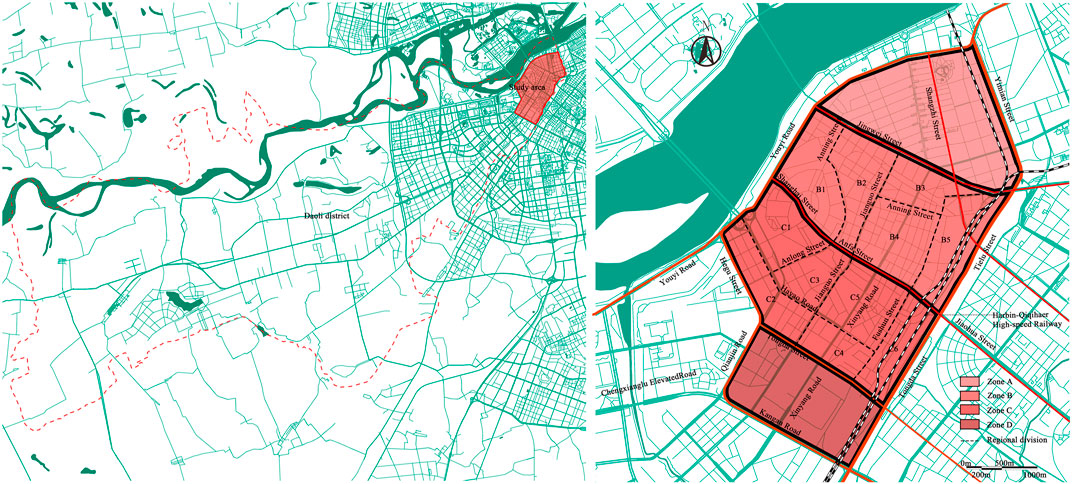
FIGURE 1. Study area map.
The research area is divided into four parts based on the landscape of main roads in Daoli District so that it is much easier to make the subsequent analysis and summarize the calculation results. The land area is divided into four districts, namely, A, B, C, and D, by Jingwei Street, Shanghai Street, Anfa Street, and Tongda Street. Since District B and District C cover large areas with complex situations, District B and District C are further divided for more accurate analysis. District B and District C are further divided into B1, B2, B3, B4, B5, C1, C2, C3, C4, C5, and C6 along Hayao Road, Anlong Street, Anning Street, Jianguo Street, and Fushun Street, respectively (Figure 1). Generally speaking, the whole land area is divided into four major districts, including 11 small districts. The research is analyzed based on these districts.
2.2 Data
In order to make a spatial evaluation and accurately locate the disordered spatial sites, this study adopts the street view image of Baidu Maps for the built environment audit. Baidu Maps (https://map.baidu.com/) can provide the latest street view images covering most of the urban roads in the first ring road of Harbin (May 2019), with the maximum resolution (width × height) of 1024 × 512 (Chen et al., 2020). Based on the data from Baidu Map, this paper selects streets as the basic units of research. In this paper, based on Baidu Street View images, more than 200 streets within the old city area of Daoli District of Harbin City are used as the original data for the study. Considering the huge workload of downloading all street view images in the research area, the paper uses ArcGIS to obtain points of street view images from 4-dimensional maps at equal intervals (Ye et al., 2019). By manually comparing the homogeneity of urban landscape features in the street view images intercepted at different distances, the homogeneity of landscape types covered by the images intercepted at less than 100 m is very high and some landscape features are even overlapped. The homogeneity of the images intercepted at more than 100 m is very low, so it is easy to omit some street view features. Finally, the sampling distance is set as 100 m. This research finally takes 1,047 points with street view images in the study area (each point can provide a 360° scene) and then captures four street view images, which are parallel to the road (front and back) and perpendicular to the road direction (left and right) at each observation point by the Baidu Map API (Tang et al., 2016). This acquisition form fully covers the environment around the viewpoints and collects a total of 4,188 street-view images.
In addition, the basic GIS data of Harbin City, road network data, and social network data, including microblogs and public comments, are considered in a holistic manner so as to discuss the relationship between urban spatial disorder and public health from a micro perspective at the street level.
2.3 Research methods
In order to facilitate data acquisition and calculation, this paper adopts the following four types of calculation technologies: 1) Data crawling. Through the Python programming language, Baidu Maps is used to obtain the street view image data, multi-source open data, street view, coordinates, angles, and other information of each sample point to support the indicator calculation. 2) Statistical analysis. Through SPSS 24.0, the obtained indicator data are analyzed mathematically and physically to prove results (Long and Zhou, 2016). 3) Off-site built environment audit. In view of the impact of weather and season on the pictures, factors including weather, season, and traffic conditions are excluded during the audit. 4) Street evaluation. The spatial disorder indicators and spatial health are taken as the dimensions to evaluate street health. In the meantime, cluster analysis is carried out and solutions for the spatial situation and transformation potential of various streets are proposed (Shi, 2021).
In this paper, the off-site environmental audit method is adopted to measure the health of the street view space displayed in the street view images of the old urban area of Daoli District of Harbin City. The existing literature has proved that the audit results of the scoring team with a professional background are more effective than those of laymen. Therefore, in this paper, four auditors with professional backgrounds in architecture or urban planning were selected to conduct the audit.
The research process includes the following four main steps: 1) We used ArcGIS to select observation points and obtain four hundred-degree street view data of each street scenic spot; 2) The obtained street view data was sorted out by SPSS, and the data was handed over to the professional auditor of urban and rural planning for spatial disorder score; 3) The score data was imported into ArcGIS to calculate the spatial disorder score, and the spatial disorder measure map was obtained; 4) The street spatial disorder in Daoli Old town of Harbin was evaluated and analyzed according to the spatial disorder measure map. Finally, we put forward the classification improvement strategy.
In order to minimize the statistical errors caused by the auditors’ cognitive backgrounds, the auditors identified the street scene images in four directions of each street scenic spot based on a unified scoring system and scored the spatial disorder elements in the image using a dichotomous approach, that is, the existing disorder elements are counted as one, while the non-existent elements are counted as zero (Chen and Long, 2015; Yu et al., 2021). Finally, various scores are combined to form the evaluation results of the spatial quality.
2.4 Construction of spatial disorder measures
2.4.1 Selection of spatial disorder indicators
First of all, priority is given to the evaluation indicator system of urban public space quality, which is mainly based on the Beijing City Laboratory (BCL) (Chen et al., 2020), as the evaluation indicator of street space quality. Based on the street landscape and building facade information provided by the street view image, the indicator system selects representative elements for analysis, specifically including five types of first-class evaluation indicators-architecture, commercial activities on the streets, environmental greening, roads, and infrastructure, as well as 19 secondary indicators that are further subdivided (Table 1).
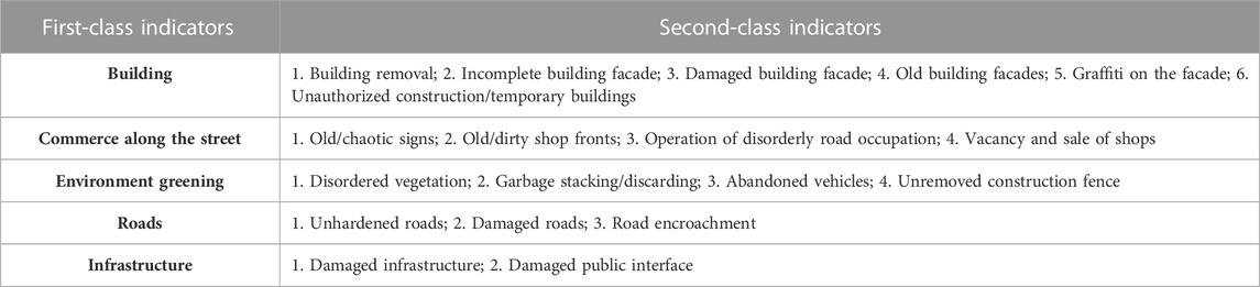
TABLE 1. Selection of evaluation indicators for space quality.
On the other hand, as an important part of the old city of Harbin, the street space in the old urban area of Daoli District is featured by the alternation of old and new. Many old streets are narrow, relatively close, and messy. Therefore, in terms of space quality, the space quality evaluation indicators also represent the public health problems of street space to a certain extent (Table 2).
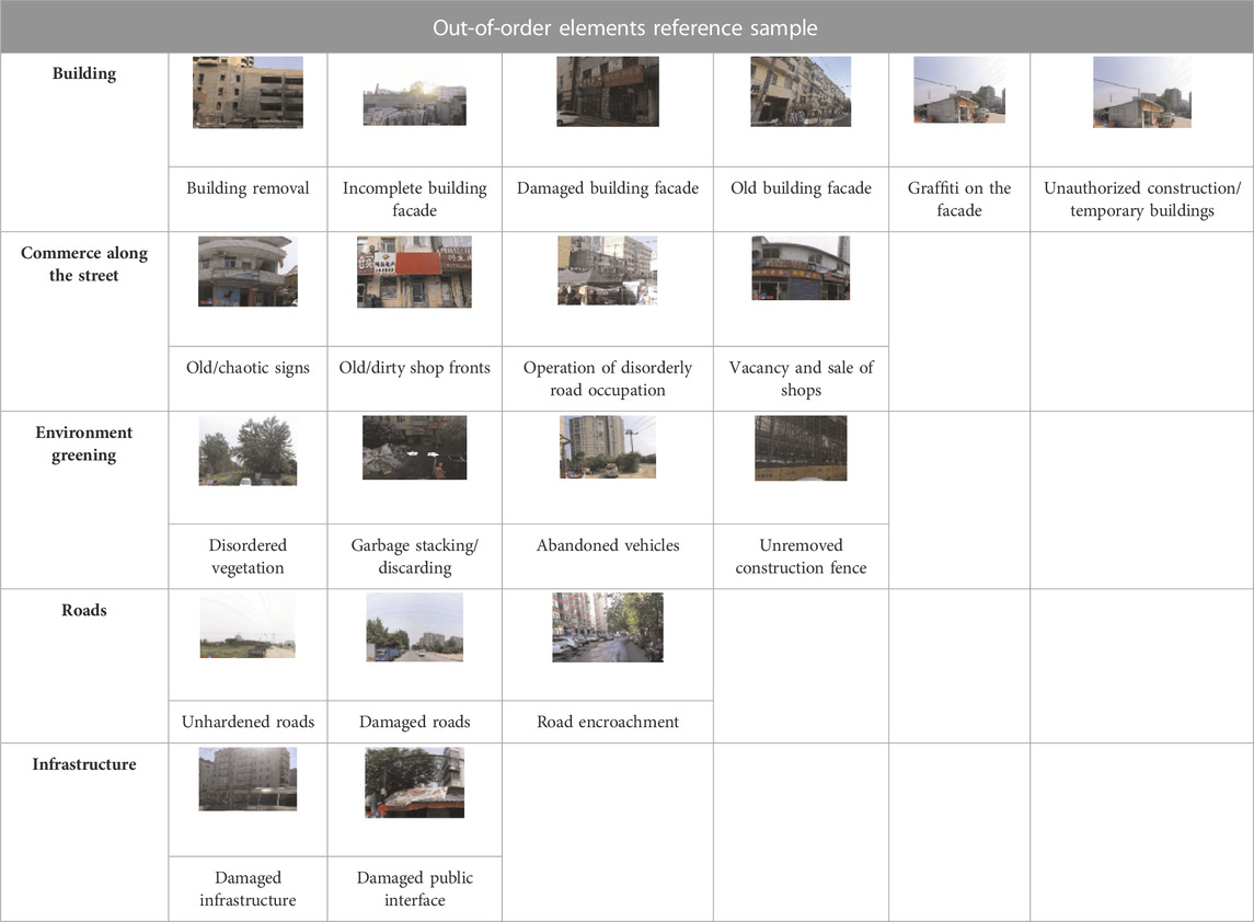
TABLE 2. Extraction of reference samples of spatial disorder elements in daoli district of harbin city.
2.4.2 Indicator calculation
According to the results measured based on the evaluation system and the formula, the disorder of street space can be calculated, which can more objectively show spatial degradation (Ye et al., 2019; Chen et al., 2020). The specific formula is as follows:
In Formula (1), D is the degree of overall spatial disorder, n is the number of street scenes with disordered elements, and street scenes with disordered elements refer to the spatial disorder of street scenes as long as any unordered elements are recognized in images in any direction of street scenes (Naik et al., 2017); N means the total number of street scenes with a total of 1,047 points (Table 2).
3 Results and discussion
3.1 Status cluster analysis
3.1.1 Overall disorder degree measurement and distribution characteristics
Based on the results of the virtual audit, this paper calculates the total score of the disorder elements of the street view image in four directions for each street view observation point, and the score of each street viewpoint ranges from 0 to 76 points (Sun and Wang, 2021). Among them, 0 point indicates that there is no disorder element in the four directions of a street scene, and 76 points mean that all disorder elements (19 elements in total) are identified in the four directions of a street scene (Long and Zhou, 2016).
Subsequently, the spatial location and visual expression are carried out through ArcGIS. It shows the total score of disorder elements identified for the street scenic spots, as shown in Figure 2, and the score is divided into four fractions by quartile, namely, 1, 1–4, 4-9, and 9–39 (Zhang et al., 2019; Chen et al., 2020). Some street scenic spots with a disorder score of zero will not be displayed. The darker the color in the figure, the worse the spatial health of the observation point.
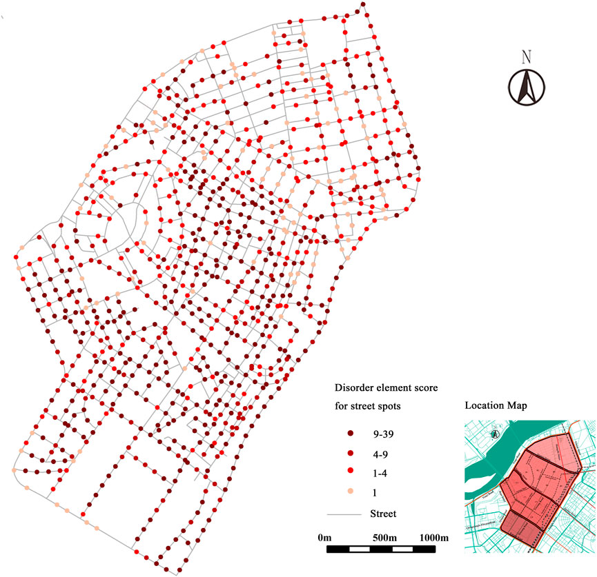
FIGURE 2. The score of Spatial Disorder Elements of 1047 Street Scenic Spots in Daoli District of Harbin City.
Based on the calculation formula of the degree of spatial disorder (Figure 2), the urban spatial disorder in the old urban area of Daoli District of Harbin City is 87.36%. The building elements have the highest score (78.70%), followed by street commerce (72.68%), and the spatial disorder of infrastructure has the lowest score (17.48%) (Table 3). According to the spatial disorder map of the overall street scenic spot elements, the spatial disorder is more obvious in B2, B3, B4, C3, C4, C5, and D districts. The sequence of the old urban area of the Anzi section in Daoli District composed of B2, B3, B4, C3, C4, and C5 is the most serious. In Aijian, District C1, District B1, and the central street of District A have better space health. The overall dilapidation is serious, showing the characteristics of large-scale tiling in districts B and C.
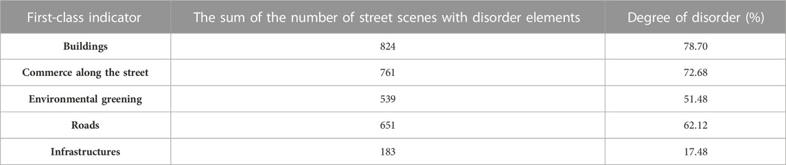
TABLE 3. Number and degree of disorder street scenes in daoli district of harbin city.
At the same time, we investigated the building years and building history of the Daocheng Old Town of Harbin City (Figure 3) and found that the Central Street area located in Zone A has long building years, historical significance, is relatively well preserved, and has perfect maintenance and repair program, leading to the central Street and has become a famous scenic spot in Harbin and one of the sources of tourism, which boosts the economy of Harbin. On the other hand, the old urban area of Daoli District, composed of B2, B3, B4, C3, C4, and C5, has a long history but most of the buildings are residential buildings with poor building maintenance, making them the slowest economic development area in the main urban area of Daoli. Aijian area composed of B1 and C1 is a fast-developing area in the central area of Daoli with a new construction period and late economic development. At present, it belongs to the newer area of Daoli Old City. It can be seen that the spatial disorder of the whole of Daoli Old Town is closely related to the development history and economic situation of Harbin. As the central street with a long history in Harbin, the economy is leading and the architecture has historical characteristics, so the spatial disorder is relatively light. Anzi District has backward economic development and old buildings, so the overall spatial disorder is more serious.
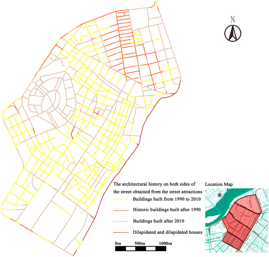
FIGURE 3. The historical age chart of buildings on both sides of the streets in the old town of Daoli District of Harbin City.
3.1.2 Characteristics and distribution of spatial disorder elements
According to the evaluation results, from the perspective of five categories of first-class indicators, buildings in the elements of spatial disorder in the old urban area of Daoli District of Harbin City account for the largest proportion, indicating that the dilapidated commerce along the street in this area is the most serious (Figure 4). From the subdivided 19 secondary indicators, building facades, encroached roads, and old and dirty road surfaces become the top three most frequent elements of spatial disorder. The primary concerns in the process of improving and upgrading the space quality of the old urban area of Daoli District of Harbin City reflect the urgent need to carry out maintenance, repair, and organic renewal of the dilapidated, damaged, and chaotic buildings of the old urban area of Daoli District of Harbin City. However, in the evaluation of space health in the old urban area of Daoli District of Harbin City, the two disorder elements, namely, the damage to building facades and the old and chaotic signs, happen in a certain frequency, resulting in the urban landscape of dilapidated building planes in the old urban area of Daoli District of Harbin City.
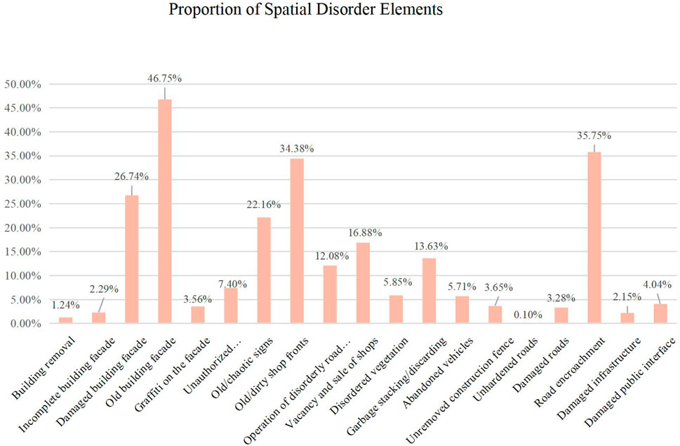
FIGURE 4. The proportion of Spatial Disorder Elements in 1047 Street Scenic Spots.
In terms of distribution characteristics, generally speaking, the areas with high degrees of various disorder elements are B2, B3, B4, C3, C4, C5, and D; that is, the old urban center and southwest of Anzi District. However, based on the data from the observation points located in old building facades with road encroachment or defilement, disorder elements are basically all over the whole area of the second-ring road, such as the old building facades and road encroachment; other elements are mainly distributed in B2, B3, B4, C3, C4, and C5; the closer they are to the old city center, the more dilapidated the B4 and C5 districts are. Disorder elements, such as disorder plants and garbage stacking and discarding, reflect that the overall urban landscape of the old urban area of Daoli District in Harbin is old and dilapidated to varying degrees. With the continuous and large-scale extension of urban space, Districts A, B1, C1, and the side close to the Songhua River show a gradually improving trend. In general, the old urban area is relatively underdeveloped in terms of facilities, fragile ecological environment, and inefficient land use (Figure 5).
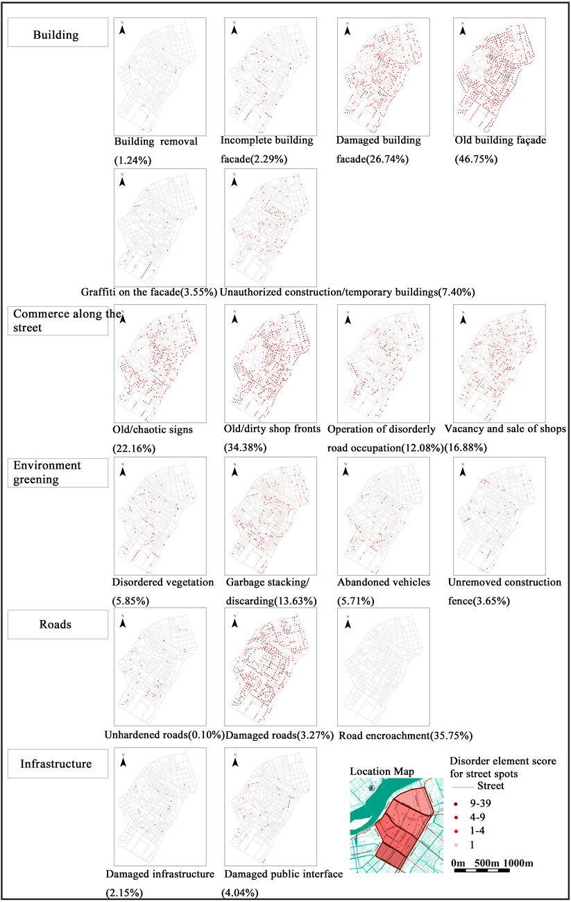
FIGURE 5. The score of Disorder Elements of Scenic Spots in Second-class Indicator Street of Spatial Disorder.
Compared with the fact that the space disorder of Anzi is more serious, the building disorder of B1 and C1 in the Aijian District is improved. As Aijian District is a relatively new area in Daoli district and its economic situation is relatively good, the building division of the whole Aijian District is zero, the building appearance and the facade of commercial pavement are relatively complete, and the roads and infrastructure are relatively perfect. Zone A is the main tourist attraction of Harbin and tourism is also an industry strongly supported by the Harbin government. The maintenance measures for the buildings and roads of Central Street are relatively complete, and the maintenance funds are relatively in place. Therefore, there are no problems such as road encroachment and building unpacking in the whole Central Street area, and only some buildings with a long history have the problem of facade damage.
3.2 Classification improvement strategy
3.2.1 Countermeasures for building space disorder
The evaluation results show that the building space disorder in the old urban area of Daoli District of Harbin City is the most serious, and it is as high as 78.7%. The aging and damage of building facades caused by the lack of maintenance and poor management of building facades are more obvious (Rundle et al., 2011). The degree of aging and disorder of building facades is the highest, reaching 46.75%, followed by the degree of damage of building facades, which is approximately 26.47%. Therefore, to solve the problem of building space disorder, this paper proposes to strengthen the quality control of building facades and informal building management to ensure the integrity of the street profile. As one of the districts with the longest building life in Harbin, the old urban area of Daoli District should improve the local buildings from the following aspects:
1) For residential land roads. It is necessary to strengthen the post-repair and management of old buildings, renovate and update buildings and building facade components that affect the street beauty and pedestrian traffic, and dismantle the illegal or temporary buildings (Li and Long, 2019). With the longest building life and the most serious aging problem, the “An” and “Guang” sections need to go through a unified renovation, and a renovation strategy for the residential area should be carried out. “Old and dilapidated” building facades should be renovated forcefully. The building facades and the urban landscape should be preserved by using exterior painting, landscape blocking, and other methods. The improvement of building façade quality and aesthetics have the following advantages: i) it meets the residents’ desire for a better urban living environment, ii) it alleviates the anxiety and other negative emotions caused by disorder phenomena, such as abandoned buildings and lack of maintenance, and iii) it creates a positive psychological perception among local residents.
2) In view of disorder problems, such as incomplete building facades and building roads in residential areas without authorization, the government should uniformly manage them, dismantle the illegal and privately built buildings, improve the street appearance, and ensure the safety of residents. For roads on commercial land (Shi, 2021), details and diversity should be provided for the overall segmentation and rhythm of the interface in the architectural design and reconstruction plan of incomplete facades, such as facade materials, structures, and details. Therefore, the visual experience is diversified, especially for the places near the ground, street corners, key sections, and visual nodes.
3) For housing demolition, it is necessary to focus on confirming the ownership of land and carry out targeted “urban renovation” for dilapidated or vacant houses.
4) Priority should be given to improving construction quality in economically backward areas, attracting residents to move in, enhancing street space vitality, and improving economic conditions in backward areas, thus forming a good cycle of disorder improvement and economic improvement.
3.2.2 Countermeasures for commercial space disorder along the street
The disorder of commercial space mainly is defined as the old, dirty, and chaotic shops and signs along the street, and the improper use of the front of the commercial area along the street, which leads to a disorderly operation on the road.
It can be strengthened from the following aspects: 1) For the " dilapidated and narrow” commercial space at the bottom of the road in the old urban area of the Daoli District residential land, the façade should be repaired and renovated (Yu et al., 2021). When the lower floors are used for commercial and retail uses, the methods, such as materials and rhythm, are used to create a positive business interface, and guide the owners to maintain and update it regularly; 2) For areas with severe road occupation (roads with mixed land use), the overall relationship between the ground floor buildings and the street space should be considered, the building exits should be reasonably controlled and used, and the unqualified outdoor commercial facilities should be strictly managed. For the “morning market” and “night market” in some areas (Gong and Bai, 2021), a reasonable area should be allocated to the “morning market” and “night market within a time limit, and these two markets should be managed uniformly. For example, according to Shanghai guidelines, “temporary facilities” can be designed in combination with commercial swings, outdoor seats, landscape facilities, etc. (Tang et al., 2016). However, problems such as non-standard temporary commercial facilities and turbulences to pedestrian traffic should be avoided; 3) For the roads on the commercial land in the Central Street Business District and Aijian Business District, coordination between the overall style and features of the ground floor business and the city should be made first, including the design of street signboards, building facade materials, building colors, and night lighting. Creating a commercial atmosphere and compliance management can effectively increase the activity of urban street space. A reasonable outer space can increase the possibility of social interaction and provide more options for residents’ outdoor activities, thus promoting public health.
3.2.3 Countermeasures for space disorder of environmental greening
The disorder of environmental greening in the old urban area of Daoli District mainly focuses on two aspects: garbage piles and vegetation, and abandoned vehicles placed in a disorderly manner. Due to the lack of management and maintenance of greening facilities in the old urban area, greening is chaotic; at the same time, garbage recycling of old streets is poorly managed, so the corner of the street can easily become a waste corner, and no one can handle it. It can be improved from the following aspects: 1) The standardized management of municipal sanitation and engineering construction should be strengthened, and attention should be given to garbage cleaning, greening maintenance, and the overall environmental management of back streets and alleys and urban fringe areas; 2) Attention should be given to the overall ecological and landscape design; tree ponds, rain gardens, and other sponge facilities should be arranged according to local conditions, and the integration of planting and maintenance should be considered. Adequate and well-maintained street greening can improve the visual environment in the landscape; the greening environment can be leveraged to improve people’s mental health, promote residents’ willingness to participate in outdoor activities, and enhance people’s perception of outdoor space, so as to relieve pressure and improve mental health in a holistic manner.
3.2.4 Countermeasures for road space disorder
The road space disorder in the old urban area is mainly manifested in road pavement damage and item accumulation encroaching on the road space. The disorder rate of road encroachment in the old urban area of Daoli District of Harbin City is as high as 35.75%, ranking third among all the reasons. As a main problem affecting the health of street space, it is mainly managed based on the “vehicle-oriented” transportation concept for a long time and little attention has been paid to the pavement of the pedestrian space and the layout and maintenance of walking and cycling facilities. At the same time, inadequate parking planning in the old urban area has led to the contradiction of more cars and fewer parking spaces in the old urban area (Vich et al., 2019), resulting in a serious parking problem on the road. The disorder of residential land roads can be improved from the following aspects:
1) Based on the vacant land around the streets of the old urban area, special parking lots and underground parking lots should be planned in an orderly manner to reduce the contradiction of more cars and less space and to reduce the problem of a slow traffic system.
2) As most guidelines propose, great attention should be given to the impact of pavement and sturdiness on the urban landscape and impression. Beautiful, durable, anti-skid, and targeted pavement materials should be used and urban management and maintenance should be strengthened (Franzini et al., 2007).
3) Encouraging slow and friendly walks. For example, in commercial streets, residential areas, and other roads, pedestrian and cycling pathways should be arranged during the pavement design. Attention should be paid to the connection with surrounding landscape belts and rest nodes (Kouis et al., 2019), and the traffic of vehicles should be limited to ensure the comfort and safety of the walking environment. In the long run, appropriate pavements also provide a guarantee for road management and maintenance, and more efforts should be made to reduce the deterioration of pavement damage caused by road occupation, crossing, and illegal parking.
3.2.5 Countermeasures for infrastructure space disorder
Due to the long service life and immature planning, the old urban area suffers from insufficient public facilities, a disordered layout, outdated style, and disrepair. Therefore, the transformation of the old city should emphasize the coordination, functionality, and intensification of the infrastructure layout. Specific improvement strategies are as follows: 1) To ensure smooth walking pathways, the negative impact of unreasonably arranged street lights, street trees, garbage cans, and ground walking signs needs to be reduced (Long & Zhou, 2016); 2) Renovating the existing infrastructure based on the interaction between facilities and people and improving the service efficiency of urban public facilities will help increase residents’ use of outdoor public space, and improve people’s willingness to travel in the city, commute, and communicate in the urban public space (Table 4).
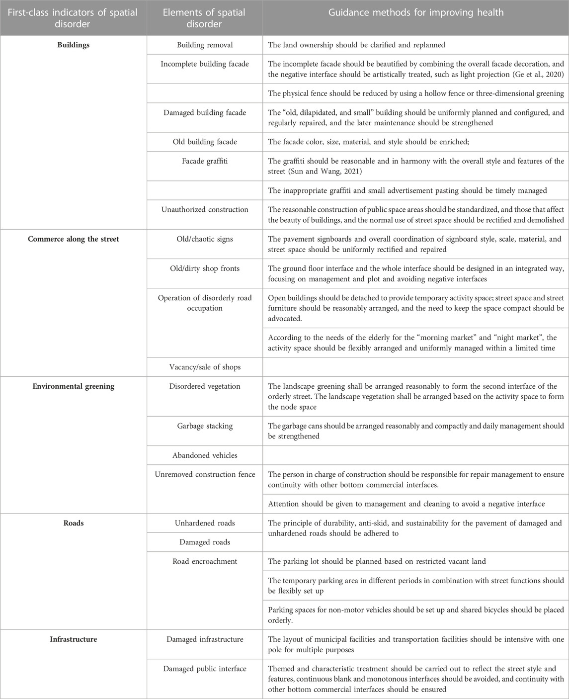
TABLE 4. Street health guidance strategy based on the first-class indicator of spatial disorder.
4 Conclusion
Research on urban space health is the top priority in China because China has already entered a certain development level and is transforming from “quantity” to “quality” development (Chen et al., 2020). In order to build a living environment conducive to public health and meet the demands of public health for urban space, the local decision-makers need to decide on the built environment that can guide and respond to how to improve the rate of street health and solve the problem of spatial disorder (Zhou et al., 2022).
Based on the virtual audit and machine learning methods of the built environment of street view images, the paper obtains the preliminary measurement and evaluation results of the street space health in the old urban area of Daoli District of Harbin City. It systematically sorts out the insufficient local street space health in the context of the old urban area. Based on practical experience at home and abroad, it proposes urban design strategies based on five categories of spatial disorder and 19 specific elements. On the one hand, it is beneficial for urban managers and researchers to enrich their systematic understanding of spatial quality characteristics and laws, so as to provide sights for the decision-makers on planning management and design response, and to improve urban practice and management strategies by proposing urban design strategies and spatial intervention measures for the phenomenon of spatial disorder. The historical age chart of buildings on both sides of the streets in Daoli Old Town of Harbin City also shows how the old city, as a historic section, can achieve a virtuous cycle of improving disorder by maintaining the history and improving economic development. On the other hand, the health improvement of humanistic street space discussed in the paper is conducive to improving the quality of urban residents’ living environment. From the perspective of urban design and management maintenance, the paper discusses the strategies and methods for the maintenance, renovation, and organic renewal of the built environment to promote public health. Also, more targeted and more suitable strategies for public health are proposed to further provide refined urban management and improve the quality and efficiency of the human living environment.
Data availability statement
The original contributions presented in the study are included in the article/Supplementary Material, further inquiries can be directed to the corresponding author.
Author contributions
TW wrote the draft of the manuscript. TW and MW contributed to data curation, analysis. MW contributed to manuscript revision. All authors approved the submitted version.
Conflict of interest
The authors declare that the research was conducted in the absence of any commercial or financial relationships that could be construed as a potential conflict of interest.
Publisher’s note
All claims expressed in this article are solely those of the authors and do not necessarily represent those of their affiliated organizations, or those of the publisher, the editors and the reviewers. Any product that may be evaluated in this article, or claim that may be made by its manufacturer, is not guaranteed or endorsed by the publisher.
References
Chen, C., Chen, J. J., Jia, Z. M., Zheng, Z., Ma, S., Long, Y., et al. (2020). Limb ischemic preconditioning ameliorates renal microcirculation through activation of PI3K/Akt/eNOS signaling pathway after acute kidney injury. South. Constr. 25 (02), 10–18. doi:10.1186/s40001-020-00407-4
Chen, J. J., and Long, Y. (2015). Identification, measurement, externality and intervention of elements of disorder in urban public space. Time Archit. (01), 44–50.
Franzini, L., O’Brien Caughy, M., Nettles, S. M., and O’Campo, P. (2007). Perceptions of disorder: Contributions of neighborhood characteristics to subjective perceptions of disorder. J. Environ. Psychol. 28 (1), 83–93. doi:10.1016/j.jenvp.2007.08.003
Ge, Y., Shen, X., and Cai, C. T. (2020). Theory, methodology and practice of healthy street design. Shanghai Urban Plan. (02), 49–56.
Gong, W. J., and Bai, X. P. (2021). Study on the shared design of living street space in settlements from a health perspective. Archit. Creat. (06), 179–190.
Kouis, P., Kakkoura, M., Ziogas, K., Paschalidou, A. Κ., and Papatheodorou, S. I. (2019). The effect of ambient air temperature on cardiovascular and respiratory mortality in Thessaloniki, Greece. Sci. Total Environ. 647, 1351–1358. doi:10.1016/j.scitotenv.2018.08.106
Li, Z., and Long, Y. (2019). Analysis of spatial quality changes of shrinking urban streets based on dynamic street view image recognition - taking Qiqihar as an example. Urban Archit. 6, 21–25.
Long, Y., and Zhou, Y. (2016). Quantitative evaluation of street vitality and analysis of influencing factors - chengdu as an example. New Constr. 1, 52–57.
Naik, N., Kominers, S. D., Raskar, R., Glaeser, E. L., and Hidalgo, C. A. (2017). Computer vision uncovers predictors of physical urban change. Proc. Natl. Acad. Sci. 114 (29), 7571–7576. doi:10.1073/pnas.1619003114
Rundle, A. G., Bader, M. D. M., Richards, C. A., Neckerman, K. M., and Teitler, J. O. (2011). Using Google street view to audit neighborhood environments. Am. J. Prev. Med. 40 (1), 94–100. doi:10.1016/j.amepre.2010.09.034
Shi, J. Q. (2021). Commerc 5ial renewal design for marketplace-type communities based on spatial disorder theory. Shanghai, China: Shanghai Normal University.
Sun, R. F., and Wang, Y. Y. (2021). Research on the construction of urban street space quality evaluation system. Anhui Archit. 28 (03), 16–17.
Tang, J. X., Long, Y., Zhai, Y., and Ma, Y. T. (2016). Measurements of spatial quality of streets, evaluation of changes and identification of influencing factors--analysis based on large-scale multi-temporal streetscape images. New Constr. 22(05), 110–115.
Vich, G., Marquet, O., and Miralles-Guasch, C. (2019). Green streetscape and walking: Exploring active mobility patterns in dense and compact cities. J. Transp. Health 12, 50–59. doi:10.1016/j.jth.2018.11.003
Ye, Y., Zhang, Z. X., Zhang, X. H., and Zeng, W. (2019). Human-scale quality on streets: A large-scale and efficient analytical approach based on street view images and new urban analytical tools. Int. Urban Plan. 34 (01), 18–27. doi:10.22217/upi.2018.490
Yu, Y., Jiang, Y. Q., and Zhang, Q. Y. (2021). Study of urban street health impact pathways and spatial elements. Scen. Gard. 28 (02), 55–61.
Zhang, L. Y., Pei, T., Chen, Y. J., Song, C., and Liu, X. Q. (2019). A review of urban environment evaluation research based on street view images. J. Geoinformation Sci. 21 (01), 46–58.
Keywords: street space, space health, spatial disorder, quantitative measurements, property of land usage, evaluation
Citation: Wan T and Wang M (2023) Large-scale measurement of urban streets’ space health based on the spatial disorder theory—A case study on the old urban area of Daoli District of Harbin City. Front. Environ. Sci. 11:1127910. doi: 10.3389/fenvs.2023.1127910
Received: 20 December 2022; Accepted: 17 April 2023;
Published: 05 May 2023.
Edited by:
Pedzisai Kowe, Midlands State University, ZimbabweReviewed by:
Voltaire Alvarado Peterson, University of Concepcion, ChileTatenda Musasa, Midlands State University, Zimbabwe
Copyright © 2023 Wan and Wang. This is an open-access article distributed under the terms of the Creative Commons Attribution License (CC BY). The use, distribution or reproduction in other forums is permitted, provided the original author(s) and the copyright owner(s) are credited and that the original publication in this journal is cited, in accordance with accepted academic practice. No use, distribution or reproduction is permitted which does not comply with these terms.
*Correspondence: Mingxue Wang, d2FuZ19taW5neHVlQG91dGxvb2suY29t