 Yisong Ge
 Chengzhi Li
 Tai Zhang1,2
 Bin Wang
- 1College of Ecology and Environment, Xinjiang University, Urumqi, China
- 2Key Laboratory of Oasis Ecology Ministry of Education, Xinjiang University, Urumqi, China
- 3Xinjiang Jinghe Observation and Research Station of Temperate Desert Ecosystem, Ministry of Education, Jinghe, Xinjiang, China
Habitat quality assessment is an important basis for ecological restoration practice. Taking the Tacheng region as an example, the InVEST model was used to evaluate the habitat quality of the Tacheng region in five periods from 2000 to 2020, and analyze the reasons for its changes, to provide theoretical guidance for ecological restoration practice in arid areas. The conclusions were that from 2000 to 2020, the habitat quality in the Tacheng region improved slightly, and the value of the habitat index in the Tacheng region was the highest in 2010, which was 0.577, and then decreased slightly. The habitat quality in the Tacheng region was significantly influenced by land use type conversion and precipitation. The change in land use type directly affected the change in habitat quality. The study region is located in an arid area; the forest land and grassland native to the region have more vegetation communities and genera of species and can be self-sustaining and resilient to disturbance, having high scores for habitat quality. The species of arable land is a monoculture; it cannot be self-sustaining and resilient to disturbance, and though it has high vegetation cover, the value of habitat quality is lower than that of forestland and grassland. The vegetation of unused land is rare, and the ecosystem of unused land is sensitive and vulnerable; the habitat quality scores are very low. The conversion of forest land, grassland, arable land, and unused land would directly affect the value of habitat quality, and conversion was the main factor affecting the change in habitat quality. In addition, precipitation was also an important factor affecting the change in habitat quality in the Tacheng region, which affected the biomass of natural vegetation and then affected the habitat quality. The results provided the temporal and spatial change of habitat quality and its driving forces in the Tacheng region, which helps determine appropriate measures and sites in ecological restoration projects.
1 Introduction
The ecological environment in an arid area is fragile, and habitat quality is poor. Rapid economic development, urban expansion, and farmland reclamation in arid areas result in habitat fragmentation, various environmental problems, a reduction in biodiversity (Qiu et al., 2017; Zhang et al., 2021), and deterioration of the ecological environmental quality. Ecological restoration projects need to be carried out immediately. Ecological restoration planning is a prerequisite for the implementation of ecological restoration projects. Ecological restoration planning requires a clear quantitative analysis of the ecological environment in both time and space in order to delineate different governance areas in the restoration process. Therefore, improved knowledge on the spatial and temporal analysis of ecological environmental quality changes is needed.
The habitat quality index refers to the ability of an ecosystem to provide individuals and populations with sustainable development within a certain spatial and temporal range (Nelson et al., 2009; He et al., 2017; Chen et al., 2021). The habitat quality index is usually used to evaluate the biodiversity of an ecosystem and ecological services. The change in the habitat quality index is affected by many factors. Land use change is one of the most important factors directly affecting the habitat quality index. In general, forest land and grassland have excellent habitat quality with a variety of species, numerous plant communities, and the capacity to be self-sustaining and adaptable to disturbances (Chen et al., 2023). Arable land typically has a monoculture with high vegetation cover, with moderate habitat quality. The plant species of unused land is rare, and its ecosystem is sensitive and vulnerable, with very poor habitat quality. The conversion of forest land, grassland, arable land, and unused land would directly affect the value of habitat quality (Li et al., 2022a; Wei et al., 2022). Land reclamation will change the structure of the ecosystem and destroy the connectivity of the landscape (Xu et al., 2019; Berta Aneseyee et al., 2020), as well as the material cycle and energy flow inside and outside the habitat, thus affecting the ecological environment quality. The quantitative description of the habitat quality index is difficult.
The habitat quality index had been calculated with complex models, such as the CA-Markov model, InVEST model, and PLUS model (Xu et al., 2020; Wang et al., 2021; Li et al., 2022b). The spatial distribution and evolution characteristics of regional habitat quality indices had been revealed. In regions with a dense population, rich natural resources, and rapid socio-economic development, the value of the habitat quality index was significantly affected by human activities (Zhao et al., 2022a), showing a habitat fragmentation phenomenon. Cultivated land and urban construction occupied a large amount of land, and the conversion of woodland and grassland to cultivated land, construction land, and other land types significantly reduced the regional habitat quality (Jiang and Wu, 2021). Many scholars had also discovered that land use had a great impact on the habitat quality index in the arid zone (Zhang et al., 2022; Zhang et al., 2020a; Li et al., 2020; Wang and Cheng, 2022). With a sparse population, poor vegetation cover, and high soil erodibility in the arid zone, natural factors affecting the amount of vegetation biomass, such as climate, earthquakes, and insect pests, may have a greater impact on habitat quality (Chen et al., 2014; Xie et al., 2015; Ding et al., 2016). However, natural factors such as precipitation, drought, and characteristics of regional vegetation had hardly been considered in the model calculation of habitat quality. The spatial and temporal distribution of natural factors is uneven in the arid area, which has a great impact on the ecosystem, which not only affects the service of the ecosystem but also affects the sustainable development of the region. Therefore, the impact of natural factors on regional habitat quality should be considered to enhance our knowledge of ecological restoration.
Habitat quality change is the basis of ecological restoration work. Ecological restoration engineering projects should be implemented in the areas where habitat quality has significantly deteriorated. The value of habitat quality was calculated in most of the studies. However, the reasons causing the change in habitat quality were not analyzed in most theses published, and the ecological restoration schemes implemented were not coordinated with the spatial deterioration of habitat quality, hence requiring further study in this field. In order to implement ecological restoration projects more accurately and effectively, it is crucial to investigate the factors influencing habitat quality change and quantitatively analyze the change characteristics of the habitat quality for ecological restoration.
In arid areas, where the local ecological environment is fragile and the overall quality of the habitat is poor, the degraded ecosystem is more difficult to restore. It is necessary to implement a more artificial intervention in ecological restoration, according to local conditions. However, where and when to implement ecological restoration projects is still a puzzling problem. In this context, we assume that the sharply degraded areas of habitat need to implement ecological restoration projects quickly, which can not only save manpower and financial resources but also improve the overall restoration efficiency. Hence, we conducted quantitative analysis on the overall habitat quality temporally and spatially in the Tacheng region using the habitat quality module of the InVEST model, based on multi-phase data of land use and threat sources, to explore the ecological environment quality. The influencing factors of habitat quality in the Tacheng area were analyzed through land use change and precipitation. Our goal is to put forward suitable measures of ecological restoration for areas with degraded habitat according to the factors affecting habitat quality.
2 Materials and methods
2.1 Research area
The Tacheng region is located in the northwest of Xinjiang, China, between 82°16′-87°21′E and 43°25′-47°15′N (Figure 1). The Tacheng region has an area of 10.54104 km2 × 104 km2 and includes seven cities: Tacheng City, Wusu City, Shawan City, Emin County, Yumin County, Tuoli County, and Hebuksal County. By 2020, the population of the Tacheng region was 113.8 × 10⁴, and the GDP was 73.757 billion CNY.
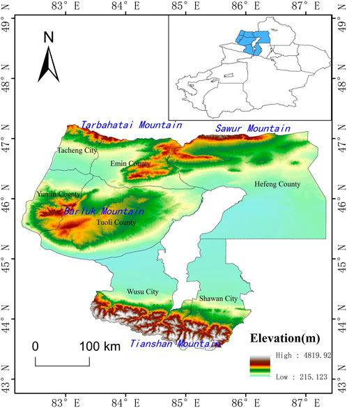
FIGURE 1. Study area location—Tacheng region, northwestern Xinjiang Uygur Autonomous Region, China, and the elevation of the Tacheng region, elevation data from the Resource and Environmental Science and Data Center of the Chinese Academy of Sciences (http://www.resdc.cn/), with a resolution of 30 m.
The Tacheng region is located in the northwest of the Junggar Basin in Xinjiang, China. The average annual temperature is 7.1°C, the average annual precipitation is about 250 mm, and the average wind speed is 2.45 m/s. The geomorphic features in the Tacheng region are mainly mountains, mountain plains, basins, valleys, and deserts. The main soil types are brown calcium soil, chestnut soil, gray desert soil, gray–brown desert soil, chernozem soil, aeolian sand soil, alpine meadow soil, and meadow brown calcium soil. The main types of ecosystems include the Haloxylon desert ecosystem, Seriphidium desert ecosystem, Festuca grassland ecosystem, Stipa grassland ecosystem, Achnatherum meadow ecosystem, Picea forest ecosystem, artificially constructed urban ecosystem, and farmland ecosystem.
The land use types are mainly unused land and grassland, accounting for 80% of the whole region. Unused land is mainly distributed in Hebuksal County, which is located in the west of Tacheng, and grassland is mainly distributed in the Tarbahatai Mountains, Sawur Mountains, Barluk Mountains, and Tianshan Mountains. Arable land accounts for approximately 16%, mainly distributed in the oasis. Water area accounts for approximately 2%, mainly consisting of the glacier area, distributed in the Tianshan Mountains above the snow line. Other types of land account for very little; for example, the amount of construction land and forest land accounts for 2%. The construction land is mainly located in the oasis, while the forest land is mostly distributed in the mountains and the shelter belt of the oasis (Figure 2).
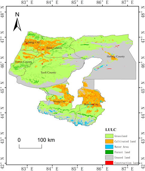
FIGURE 2. Land use and land cover (LULC) in the Tacheng region. The map describes the land use and land cover in the Tacheng region in 2020, including six primary land use types: grassland (yellow–green), cultivated land (orange), water area (blue), forest land (green), unused land (gray), and construction land (red). LULC data from the Resource and Environmental Science and Data Center of the Chinese Academy of Sciences (http://www.resdc.cn/), with a resolution of 30 m.
2.2 Data sources
The data of land use/land cover (2000, 2005, 2010, 2015, and 2020) in the Tacheng region were collected from the Resource and Environmental Science and Data Center (http://www.resdc.cn/), with a resolution of 30 m. In the classification system of China’s Multi-period Land Use Remote Sensing Monitoring Data Set (CNLUCC), land use types were divided into cultivated land, forest land, grassland, water areas, construction land, and unused land according to land utilization attributes. Precipitation data with a resolution of 1,000 m were collected from the National Earth System Science Data Center (http://www.geodata.cn/).
2.3 Research methods
The InVEST model comprehensively assesses ecosystem services and evaluates the quality of ecosystem services and their changes, realizing the quantitative assessment of ecosystem service functions and spatial visualization of the change (Peng et al., 2018; Zhao et al., 2019). Compared with other assessment methods, the InVEST model is more comprehensive and can calculate the value of various ecosystem services using land use and environmental data and socioeconomic factors under different policy scenarios (Wu et al., 2018).
Habitat quality refers to the ability of an ecosystem to provide for the survival, reproduction, and development of organisms in the habitat. It is usually used to characterize the richness of biodiversity (Li et al., 2021). The habitat quality index will be used to represent the quality of habitat and its change characteristics. The habitat quality model, a module of the InVEST model, requires the following data to evaluate habitat quality: land use data, stress factor data, habitat sensitivity data, and semi-saturation and constants (Zhu et al., 2020). Land use data is the basic index for evaluating habitat quality, and habitat quality will change with the change of land use type. Stress factor is the main factor affecting the habitat quality and has different degrees of influence with the change in distance from the habitat. Sensitivity data reflect the sensitivity of different types of habitats to stress factors. The lower the relative sensitivity of sensitive data to stress factors, the stronger the adaptability and anti-interference ability inside the habitat, and the higher the quality of the habitat (Chu et al., 2018a; Zhu and Kasimu, 2020; Lei et al., 2022).
The InVEST model’s habitat quality index value ranges between 0 and 1. The higher the value, the better the habitat quality, and the lower the value, the poorer the habitat quality (Feng et al., 2018). In this paper, the intensity table of external threats (Table 1) and the sensitivity table of threat factors (Table 2) were constructed using the habitat quality evaluation system of Wang (Baixue et al., 2021), Chu (Zhou et al., 2020), and Xu (Chu et al., 2018b), and the habitat quality map of the study area was obtained by running it in the habitat quality module of the InVEST model. The formula for calculation is as follows:
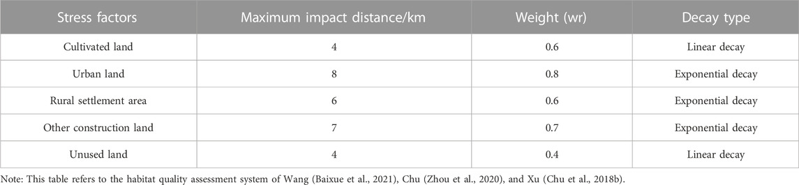
TABLE 1. Threat factors and their pressure responses.

TABLE 2. Sensitivity of land use types to habitat threat factors.
Here, Qxj is the habitat quality of grid x in land use j, Hj is the habitat suitability of type j (land use), Dxj is the habitat degradation degree of grid x in land use j, k is the semi-saturation constant, and z is the normalization constant, with a typical value of 2.5. The Dxj calculation formula is (Huang et al., 2020; Li et al., 2021; Xu et al., 2021)
Here, r is the threat source, R is the number of threat sources; y is the index of all grid numbers in the land use map; Yr is the grid number of threat source r in the land use map; ry is the grid number occupied by threat source; wr is the weight of threat source r, representing the relative destructive power of a threat factor to all habitats; and the value range is 0–1. irxy is the danger level of the threat source value of grid y to habitat grid x; βx is the reachability level of grid x, with a value ranging from 0 to 1; and the higher the value, the easier it is to reach. Sjr is the sensitivity of land use j to threat source r, and its value varies from 0 to 1. The larger the value, the more sensitive it is.
The habitat quality map of each period was obtained using the raster map of land use, threat factors, and sensitivity table in the habitat quality module in the InVEST model. In ArcGIS, the natural fracture method was used to classify the habitat quality into four grades from low to high: harsh habitat (0,0.4), general habitat (0.4,0.7), good habitat (0.7,0.9), and excellent habitat (0.9,1.0).
3 Results
3.1 Conversion of land use types
The Tacheng region’s land use transfer matrix was calculated in ArcGIS over five periods, as shown in Table 3. According to the land use transfer matrix, land use type change is more common in the Tacheng region, as evidenced by an increase in cultivated land and grassland and a decrease in unused land, woodland, and water area. From 2000 to 2005, the main conversion was from grassland and unused land to arable land, with 498.27 km2 of grassland transformed to arable land and 977.46 km2 of unused land converted to arable land. Between 2005 and 2010, the main changes were the conversion among woodland, grassland, and arable land. The area of grassland converted to arable land was 1,621.61 km2, and the area of woodland converted to grassland was 1,492.88 km2. The area of water degraded to unused land was 1,029.12 km2. The area of the unused land decreased from 40,356.35 km2 to 33,170.51 km2, most of which was converted to arable land and grassland, of which 890.04 km2 was converted to arable land and 5,947.24 km2 was converted to grassland. From 2010 to 2015, the main conversion types were still found among grassland, arable land, and woodland. The area of grassland converted to cultivated land and forestland (574.59 km2) was more than that of cultivated land and forestland converted to grassland (354.33 km2). The area of grassland decreased from 47,948.78 km2 to 47,727.5 km2. From 2015 to 2020, the main conversion types were still among woodland, grassland, and arable land. The grassland was mainly converted to cultivated land, with an area of 582.16 km2. The area of woodland converted to grassland was located in the southern woodland margin, totaling 24.74 km2. The area of unused land converted to cultivated land was mainly distributed in the southern region, totaling 25.17 km2. The area of cultivated land increased from 6,576.43 km2 to 7,108.32 km2.

TABLE 3. Land use conversion matrix in the Tacheng region from 2000 to 2020 (Unit: km2).
According to Figure 3, from 2000 to 2020, the areas of grassland, woodland, arable land, water area, and unused land in the Tacheng region changed significantly. The grassland was mainly converted into cultivated land, woodland, and unused land. The cumulative area of grassland converted to cultivated land was 3,981.15 km2, the cumulative area of grassland converted to woodland was 1,174.29 km2, and the cumulative area of grassland converted to unused land was 2,385.07 km2. Woodland was mainly converted to grassland, with a conversion area of 2,675.69 km2. Arable land was primarily converted to grassland, with a conversion area of 1,049.3 km2. The water area (glacier) was primarily converted to unused land, with a conversion area of 1,305.37 km2. The unused land was principally converted to grassland and arable land, of which the area of unused land converted to grassland was 8,411.72 km2 and the area of unused land converted to arable land was 1,464.38 km2.
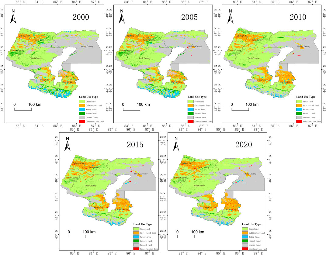
FIGURE 3. Land use change in the Tacheng region from 2000 to 2020. This map describes the land use change in the Tacheng region in 2000, 2005, 2010, 2015, and 2020. The classification of the land use includes six primary land classes: grassland (yellow–green), cultivated land (orange), water area (blue), forest land (green), unused land (gray), and construction land (red). The data were collected from the Resource and Environmental Science and Data Center of the Chinese Academy of Sciences (http://www.resdc.cn/), with a resolution of 30 m.
The change in vegetation biomass will have a direct impact on the region’s habitat quality. The habitat quality of areas with high vegetation biomass, such as woodland and grassland, is usually higher, while the habitat quality of unused soil is generally lower. The woodland and grassland native to the region have more vegetation types and genera of species and can be self-sustaining and resilient to disturbance, having high scores of habitat quality. The species of arable land and construction land is a monoculture and cannot be self-sustaining and resilient to disturbance, though it has high vegetation cover; the value of habitat quality is lower than that of woodland and grassland. The vegetation of unused land is rare, and the ecosystem of unused land is sensitive and vulnerable; the scores of habitat quality are very low. The conversion of woodland, grassland, arable land, construction land, and unused land would directly affect the value of habitat quality and is the main factor affecting the change in habitat quality. As a result, the changes in land use type directly impact on habitat quality.
3.2 Variation of precipitation
Precipitation has a significant impact on vegetation biomass and is the primary determinant of habitat quality in arid areas. Figure 4 depicts the precipitation in the Tacheng region. The annual average precipitation in the Tacheng region fluctuated to some extent between 2000 and 2020, but the change was not significant. The average precipitation of the five periods was 197.336 mm, 211.869 mm, 224.244 mm, 225.47 mm, and 193.853 mm, respectively.
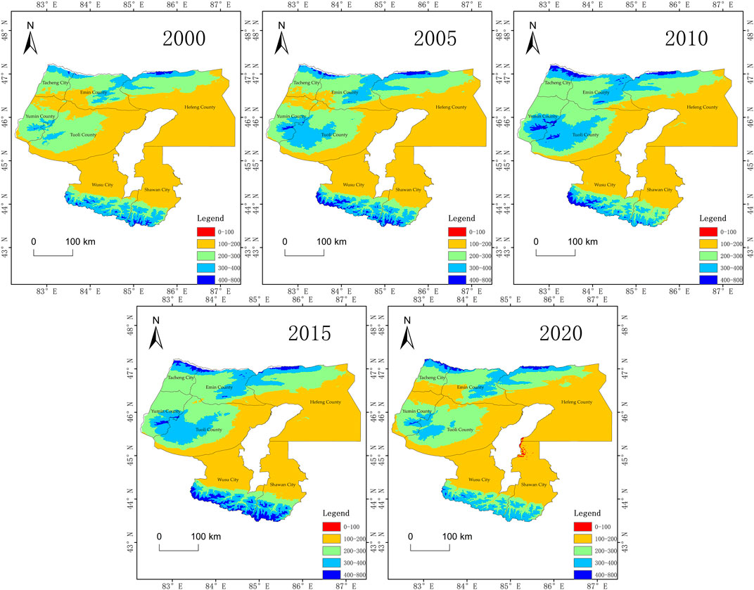
FIGURE 4. Distribution of annual precipitation in the Tacheng region from 2000 to 2020. The map describes the annual precipitation of the Tacheng region in 2000, 2005, 2010, 2015, and 2020. The annual precipitation is divided into five sections: 0–100 mm (red), 100–200 mm (orange), 200–300 mm (yellow–green), 300–400 mm (blue), and 400–800 mm (deep blue). Precipitation data with a resolution of 1,000 m are collected from the National Earth System Science Data Center of China (http://www.geodata.cn/).
Figure 4 shows that the Tarbahatai Mountains, Barluk Mountains, and Tianshan Mountains have an annual average precipitation >200 mm in the Tacheng region. These areas have abundant forest and grass resources, a high biomass of vegetation, and good habitat quality. The areas with an average annual precipitation of <200 mm are mostly desert, Gobi, and bare land, with very low vegetation biomass and poor habitat quality.
Precipitation varied significantly across the Tacheng region. The regions with significant precipitation variation were mainly the Tarbahatai Mountains, Barluk Mountains, Sawur Mountains, and Tianshan Mountains with high precipitation. From 2000 to 2005, the precipitation changes were concentrated in the Baluk Mountains and the Tianshan Mountains. The average annual precipitation increased from 200–300 mm to 300–400 mm in the large area of Barluk Mountains and from 300–400 mm to 400–800 mm in the Tianshan Mountains. From 2005 to 2010, the precipitation changes were mainly concentrated in the Tarbahatai Mountains, Baluk Mountains, and Tianshan Mountains. The average annual precipitation in almost all areas of the Tarbahatai Mountains was more than 300 mm, and the average annual precipitation in the Tarbahatai Mountains increased from 300–400 mm to 400–800 mm. The average annual precipitation in the Barluk Mountains was more than 300 mm. However, the average annual precipitation in the Tianshan Mountains decreased from 400–800 mm to 300–400 mm. From 2010 to 2015, precipitation changes were primarily concentrated in the Barluk Mountains and the Tianshan Mountains. In 2015, the average annual precipitation in the Barluk Mountains decreased, compared with 2010, with most areas ranging from 300 to 400 mm, and only a few areas with high elevations reaching 400–800 mm. However, in the Tianshan Mountains, the average annual precipitation increased, reaching 400–800 mm. From 2015 to 2020, the precipitation changes were mainly distributed in the Barluk Mountains and Tianshan Mountains. The areas of average annual precipitation of 300–400 mm in the Barluk Mountains reduced significantly. The average annual precipitation in the Barluk Mountains was only 200–300 mm. In the northern area of the Barluk Mountains, a large area had an average annual precipitation of 100–200 mm. The average annual precipitation in the Tianshan Mountains decreased from 400–800 mm to 300–400 mm.
Precipitation has a significant impact on vegetation biomass in arid regions. The regions with high precipitation always have more plants, wild animals, and biodiversity, and the community structure is more stable, often with higher habitat quality, while the low precipitation areas consist of fewer species and simple structures, frequently with lower habitat quality. With a significant variation in precipitation, the plants, wild animals, and biodiversity change, which in turn affects habitat quality. Therefore, the change in regional habitat quality will be influenced to some extent by the increase or reduction in precipitation.
3.3 Characteristics of habitat quality change
3.3.1 Temporal changes in habitat quality
The habitat quality module of the InVEST model assessed the habitat quality in the Tacheng region in 2000, 2005, 2010, 2015, and 2020. The findings are depicted in Figure 5. The graph showed that the Tacheng region’s habitat quality was generally poor. The habitat quality index had an average value of 0.567, 0.566, 0.577, 0.576, and 0.575. The Harsh habitat made up the greatest portion of the territory, at approximately 40%. The sizes of the Good and General habitats were almost similar, with each around 25%, while the area of Excellent habitats was much less (approximately 10%).
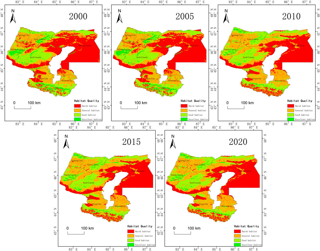
FIGURE 5. Spatial distribution of habitat quality in the Tacheng region from 2000 to 2020. The habitat quality was assessed by the InVEST model in 2000, 2005, 2010, 2015, and 2020. The data used in the model were the land use data (2000, 2005, 2010, 2015, and 2020) in the Tacheng region, which were collected from the Resource and Environmental Science and Data Center of the Chinese Academy of Sciences (http://www.resdc.cn/), with a resolution of 30 m. The habitat quality was divided into four levels: Harsh habitat (red), General habitat (orange), Good habitat (yellow–green), and Excellent habitat (green).
The Tacheng region’s habitat quality was steady between 2000 and 2020, with a slight variation. From 2000 to 2010, the habitat quality index increased and decreased slightly from 2010 to 2020. The area of Good habitat quality decreased from 44,463.38 km2 to 43,968.22 km2 between 2000 and 2005. The area of Harsh habitat decreased from 39,393.06 km2 to 38,920.66 km2 between 2000 and 2005. The quality of the environment as a whole somewhat deteriorated. From 2005 to 2010, the area of Good habitat and Excellent habitat increased rapidly from 55,589.89 km2 to 61,342.52 km2, while the area of Harsh habitat quality decreased from 38,920.66 km2 to 33,170.51 km2. The habitat quality index increased from 0.566 to 0.577. From 2010 to 2020, the area of Good habitat quality increased by 223.41 km2, while the area of Harsh habitat quality decreased by 237.30 km2. The change of habitat quality in the Tacheng region was steady.
3.3.2 Spatial distribution and variation of habitat quality
The distribution of habitat quality in the Tacheng area was not homogeneous, as shown in Figure 5. The Barluk Mountains, the Talbahatai Mountains, and the northern slope of the Tianshan Mountains were the major distribution areas for the Good and Excellent habitat regions. These regions had a greater altitude, more rain, and less human activity disruption. The General habitats, which were mostly man-made ecosystems like urban and cultivated land, were found in the oases. The Harsh habitat is mostly concentrated in the Gobi Desert.
The results of calculating the regional variation of habitat quality in the Tacheng area using ArcGIS software are displayed in Figure 6. According to the statistics of habitat area in Figure 3, the area of habitat quality change from 2000 to 2005 was 1,268.53 km2. The area showing improvement in habitat quality was 529.71 km2, mainly distributed around the Barluk Mountains. The area with habitat quality deterioration was 738.82 km2, mainly distributed in the surrounding towns of Tacheng City, Emin County, and Wusu City, and the southern area of Shawan City. The habitat quality changed most obviously from 2005 to 2010, with an area of 25,665.97 km2. The area with habitat quality improvement was 13,567.77 km2, mainly distributed in the Barluk Mountains, the Saur Mountains, and the Tianshan Mountains. The area with habitat quality deterioration was 12,098.2 km2, and the area with most serious deterioration in habitat quality was 3, 261.15 km2 in the southeast of Saurs Mountains and Tianshan Mountains, and the other little parts are mainly distributed in Tacheng City, Emin County, Tuoli County, Wusu City, and Shawan City. From 2010 to 2015, the area concerning habitat quality change was 1,525.06 km2. The improved habitat quality area was 738.44 km2, mostly in Hebuksal County and Wusu City. The area with habitat quality deterioration was 786.44 km2, with the majority of it located in Tacheng City, Wusu City, Shawan City, and Hebuksal County. The area with change in habitat quality from 2015 to 2020 was 2,726.32 km2. The area with improvement in habitat quality was 1,197.28 km2, primarily distributed in the Barluk Mountains and Tarbahatai Mountains, as well as the northern area of the Tianshan Mountains. The area of habitat quality deterioration was 1,529.04 km2, primarily in Emin County, Wusu City, and Shawan City. In arid regions, precipitation has a significant impact on vegetation biomass, which in turn affects habitat quality. Therefore, the change in regional habitat quality will be influenced to some extent by the increase or reduction in precipitation.
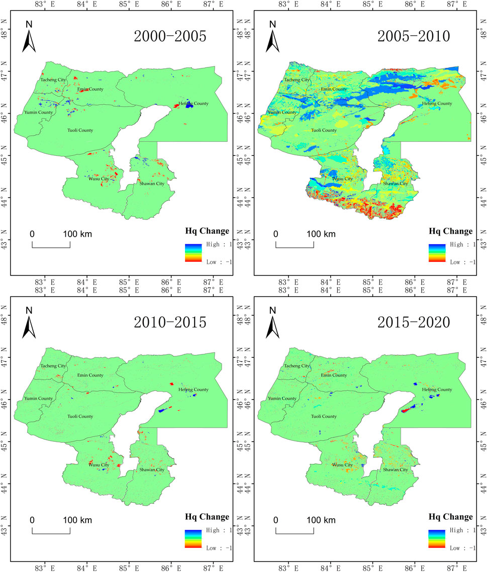
FIGURE 6. Habitat quality changes in the Tacheng region from 2000 to 2020. This map is derived from analysis of the habitat quality data, as shown in Figure 5, which reflects the changes in habitat quality in the Tacheng region from 2000 to 2005, 2005 to 2010, 2010 to 2015, and 2015 to 2020, respectively. The range of the habitat quality change is −1 to 1. Positive values represent habitat quality changes for the better, and negative values indicate habitat quality changes for the worse.
From Figures 3, 5, it can be seen that most of the areas showing habitat quality improvement were unused areas with poor habitat quality, which may benefit from implementing ecological restoration projects, such as the prohibition of grazing in fragile areas such as deserts (Wu et al., 2021). We also noticed that from 2005 to 2010, the habitat quality declined in a large area in the southern part of Tacheng. The habitat quality in these areas used to be Good or even Excellent, mainly distributed in alpine meadows, and underwent a significant degeneration, which may be due to the degraded grasslands caused by decreased precipitation and overgrazing. Around towns and cultivated land, the habitat quality changed significantly, which is disturbed by human activities.
4 Discussion
Land use change and precipitation are two of the major determining factors of regional habitat quality in dry regions, among many other variables. The quality of habitat is directly affected by changes in land use. The biomass of the vegetation inside the habitat is directly impacted by precipitation, which also has an impact on changes in habitat quality.
4.1 Impact of land use change on regional habitat quality
The regional environment background influences the change in regional habitat quality. In areas with fragile ecological environments, such as semi-arid and arid zones, woodland and grassland are prone to degradation under the influence of harsh environments, which leads to a reduction in area or habitat fragmentation, resulting in the decline of habitat quality (Mengist et al., 2021; Wu et al., 2022). Tacheng is a typical arid region. Figure 5 shows that the total habitat quality in the Tacheng region was low and the area of harsh habitat quality had the highest percentage, which was primarily distributed on unused land. The fragile ecological environments in the Tacheng region are prone to changes in habitat quality.
The change in regional habitat quality is influenced by the conversion of land use types. Human activities can affect regional habitat quality by altering the type and intensity of land use (Luan et al., 2022). For instance, overgrazing and deforestation will lower regional habitat quality, while returning farmland to forest or grassland can improve regional habitat quality (Wu et al., 2015; Wang et al., 2017). The proportion of Good habitat quality was small in the Tacheng region, but it was significant to the Tacheng region. The land use types with Excellent habitat quality were woodland and grassland, with medium and high coverage, respectively. The land use types of General habitat quality were low-cover grassland, cultivated land, and the areas surrounding construction land and cultivated land, which are important places where people build living spaces. From 2000 to 2005, the habitat quality deteriorated in Tacheng. The area of grassland and forest had shrunk by 495.16 km2. From 2005 to 2010, the habitat quality improved in northwest Tacheng, and the habitat quality index increased from 0.647 to 0.67. An area of unused land, 3,085.16 km2, was developed and utilized in northwest Tacheng, of which 2,834.13 km2 was converted to grassland. The habitat quality improved in the south of Tacheng. The regional habitat quality index decreased from 0.64 to 0.602 for the northern slope of the Tianshan Mountains. Forest, grassland, and glacier areas were degraded to unused land. From 2010 to 2020, there was a slight decline in habitat quality throughout the Tacheng region. The habitat quality index decreased from 0.577 to 0.575. The area of construction land and cultivated land in the Tacheng region increased by 18.21 km2 and 807.2 km2, respectively, when converted from forest and grassland. Land use change had a significant impact on habitat quality in the Tacheng region.
According to the Tacheng region’s land use transfer matrix, from 2000 to 2020, forestland, grassland, and unused land were transformed in a broad area, resulting in a variation in habitat quality throughout the region. The area of forestland with Good habitat quality decreased by 1,501.4 km2, while the area of grassland increased by 4,596.2 km2. A total of 6,185.66 km2 of unused land was developed, which was mainly converted to grassland and arable land. Compared with that in 2000, the habitat quality in the Tacheng region was significantly improved, although the degradation of forestland with the best habitat quality was slightly serious. From the aforementioned results, the variation in the area of forestland and grassland is the factor impacting the habitat quality change in the Tacheng region. It is not a common cognitive phenomenon that in the process of urban development, the high accumulation and expansion of construction land continuously occupy other surrounding lands, thus posing a threat to the quality of habitat (Liu et al., 2017; Zhang et al., 2020b).
4.2 Influence of precipitation change on habitat quality
The increase in precipitation is conducive to vegetation growth and can improve habitat quality in the region. The habitat quality in the arid area would be significantly affected by precipitation. In the Tacheng region, the areas with precipitation greater than 300 mm were located in mountains, mostly woodland and grassland, and the habitat quality was good. The areas with precipitation less than 200 mm were located in basins, which were mostly unused land, such as desert, saline–alkali land, with poor habitat quality.
The variation of precipitation had a great influence on habitat quality in the Tacheng region. Figure 4 shows that the annual average precipitation in the Barluk Mountains increased from 200–300 mm to 300–400 mm between 2000 and 2005, while the regional habitat quality index increased from 0.645 to 0.646, as shown in Figure 5, indicating that habitat quality improved with the increase in the annual average precipitation. From 2005 to 2010, the annual average precipitation in the Tacheng region varied significantly. The annual mean precipitation in the Tarbahatai Mountains, Saur Mountains, and Barluk Mountains was more than 300 mm, and precipitation in some regions reached 400–800 mm. The regional habitat quality index increased from 0.647 to 0.67. The habitat quality of the area with improvement in precipitation changed from poor to fair or even good. However, in the northern slope of the Tianshan Mountains, the annual average precipitation in a large area decreased from 400–800 mm to 300–400 mm, and the habitat quality deteriorated. The regional habitat quality index of the northern slope of the Tianshan Mountains decreased from 0.64 to 0.602. Almost all the areas of Good habitat quality in the region were degraded to General habitat quality. From 2010 to 2015, the average annual precipitation in the northern slope of Tianshan Mountains increased to 400–800 mm; however, due to the severely damaged ecological environment, the habitat quality in the region was not recovered completely, and the regional habitat quality index decreased from 0.602 to 0.6. From 2015 to 2020, in the northern slope of the Tianshan Mountains, the annual average precipitation decreased from 400–800 mm to 300–400 mm, and the regional habitat quality index decreased from 0.6 to 0.596. In the Barluk Mountains, the area with an average annual precipitation of 300–400 mm decreased, especially in the northern region, where the average annual precipitation decreased to 100–200 mm; however, the regional habitat quality index, which was 0.674, did not change significantly. Habitat quality was significantly affected by precipitation, especially in the mountainous region dominated by natural factors. The decrease in precipitation led to the degradation of forest and grass area, which caused damage to the local ecological environment and even led to irreversible habitat degradation. In semi-arid and arid areas, precipitation is one of the driving factors affecting the land with low vegetation coverage (Li et al., 2023). In the Tacheng region, precipitation played a major role in the mountain areas with moderate vegetation coverage. The areas with low vegetation coverage were not significantly influenced by precipitation.
4.3 Ecological restoration strategies based on habitat quality changes
As a typical arid area, the Tacheng region has low resistance and resilience of the whole ecosystem. Land use change and water resource change have significant effects on habitat quality in the Tacheng region. In 2010, glaciers and wetlands in the southern region were largely degraded, and since then, this region had poor habitat quality. Compared with ecological restoration countermeasures and schemes proposed by other scholars (Rodrigues et al., 2011; Kettenring and Tarsa, 2020; Wu et al., 2023), the practical problem of water shortage makes ecological restoration in this region difficult. In addition, it can be seen from the combination of Figures 4, 5 that even though precipitation in this region increased significantly from 2010 to 2015, the habitat quality was still poor and did not improve significantly. Second, the development and utilization of land resources has been the focus of many scholars. Rational development and utilization of land resources can not only produce certain economic and ecological values but also improve the quality of habitat in a certain region (Song et al., 2020; Zhao et al., 2022b). After 2010, the unused land in the Tacheng region was developed and utilized in a large area, mainly distributed around the town. The main types of land for conversion are construction land and farmland. In addition, in the northern piedmont area, a large area of unused land has been converted into grassland resources, which has significantly improved the habitat quality of the whole region. However, in the western area, there are still large areas of unused land that have not been developed and utilized. According to Figures 4, 5, these areas are harsh habitat areas with extremely low annual precipitation, which makes it difficult to implement most of the previous ecological restoration measures in this region, which are more difficult to develop and utilize and have no obvious restoration effect. Therefore, the rational use of land resources and the overall planning of water resources are very important to improve the habitat quality and adaptability of the whole region.
Tacheng is located in an arid region with poor environmental quality. The degradation of forestland, grassland, and water area (glacier) resulted in the degradation of region habitat quality, which had a serious effect on the natural ecosystem and the ecological environment quality. It is challenging for arid ecosystems to revert to their baseline state because they are weakly resilient and resistant. From the review of habitat quality in the Tacheng region, it is clear that the conversion of land use types and the change in annual average precipitation may cause the change in habitat quality. Ecological restoration projects can be implemented in the region where habitat quality has deteriorated. First, the regions where woodland, grassland, and glacier areas were degraded due to decreased rainfall in the Tianshan Mountains in the south of Tacheng should be designated as water source protection areas or glacier protection areas. Second, in the area with adequate rainfall (≥200 mm), a part of the grassland and woodland areas was degraded due to overgrazing and excessive carrying capacity (Xie and Sha, 2012); therefore, the ecological restoration strategies of fencing and breeding, properly prohibiting grazing, and grass replanting could be carried out to ensure that the ecological environment had naturally recovered. Third, the unused land could be rationally protected. Based on the actual situation, a nature-based solution should be implemented to utilize the water and mountain resources; grow crops, and develop agriculture, industry, or business where conditions permit. Fourth, the ecological and environmental quality of production and living spaces should be improved. In urban and rural areas, it is necessary to enhance the green landscape in towns and their surrounding areas by building green belts around the cities and raising the standard of the ecological environment in residential areas. Fifth, in the marginal zones of different habitats, such as the desert oasis transition zone and industrial and agricultural fringe areas, the irrational development and utilization of various land types had resulted in serious imbalance of ecological carrying capacity (Wu et al., 2022). In these areas, forest and grass should be restored in time, and ecological shelter belts should be built to improve the regional ecological environment (Liu et al., 2018).
In this study, precipitation and changes in land use types, two typical natural factors impacting habitat quality in arid areas, were analyzed to evaluate habitat quality in the Tacheng region and to explore the characteristics of habitat quality changes temporally and spatially. According to the change in the habitat quality value, the different ecological restoration spaces were divided, and suitable countermeasures and suggestions for different ecological restoration spaces were proposed. The other factors, such as economic activities, pollutant discharge, geographic and geomorphic conditions, temperature, salinization, soil erosion, and climate change, may also influence the habitat quality value significantly; however, those factors have not been included in this paper. In the future, those factors could be considered to propose more reasonable ecological restoration countermeasures.
5 Conclusion
The habitat quality module of the InVEST model was used to evaluate the habitat quality in the Tacheng region, and the change characteristics and causes of habitat quality in the region were analyzed from the changes in land use and rainfall, which was expected to provide theoretical support for ecological restoration practice in the Tacheng region. The main conclusions are as follows:
(1) From 2000 to 2020, the habitat quality in the Tacheng region was stable, with slight fluctuations. However, owing to the vulnerability of the ecological environment and regional differences in human activities in the study area, the habitat quality in different regions showed obvious heterogeneity.
(2) Land use change had a great impact on regional habitat quality change. The conversions between woodland, grassland, and unused land affected the habitat quality change in the Tacheng region. The increase in woodland and grassland area could effectively improve the regional habitat quality. In addition, precipitation changes also have a great impact on habitat quality, especially in areas with precipitation of ≥200 mm. Precipitation is the dominant factor in habitat quality change in grassland and woodland in mountainous areas. In the region of precipitation of <200 mm, precipitation had little influence on the regional habitat quality. In the urban and agricultural production spaces, human activities, such as land reclamation, forestation, urban construction, and other activities, affect regional habitat quality, which results in patchy changes in the local habitat quality.
(3) Ecological restoration projects may be carried out in different areas according to the causes of habitat degradation. According to the characteristics and causes of habitat quality change in the Tacheng region, in the arid area with precipitation of <200 mm, suitable ecological restoration measures, such as unused land fencing and protection in desert areas, farmland restoration to forest or grassland in fragile areas, and habitat quality improvement in urban and cultivated land and the surrounding areas, could be selected. In areas with precipitation of ≥200 mm, ecological restoration methods, such as creating nature reserves, banning grazing, and reseeding grass seeds, could be adopted.
Data availability statement
The datasets presented in this study can be found in online repositories. The names of the repository/repositories and accession number(s) can be found in the article/supplementary material.
Author contributions
Conceptualization: CL; investigation, YG, CL, TZ, and BW; resources, CL and YG; data curation, YG; writing—original draft preparation, YG; writing—review and editing, YG; visualization, YG; supervision, CL; project administration, CL; funding acquisition, CL. All authors have read and agreed to the published version of the manuscript.
Funding
This research was supported by the Third Comprehensive Scientific Investigation Project in Xinjiang (2021xjkk1103) and the Project of Tacheng District Territorial Space Ecological Restoration Planning (2021–2035).
Conflict of interest
The authors declare that the research was conducted in the absence of any commercial or financial relationships that could be construed as a potential conflict of interest.
Publisher’s note
All claims expressed in this article are solely those of the authors and do not necessarily represent those of their affiliated organizations, or those of the publisher, the editors, and the reviewers. Any product that may be evaluated in this article, or claim that may be made by its manufacturer, is not guaranteed or endorsed by the publisher.
References
Baixue, W., Weiming, C., and Shengxin, L. (2021). Impact of land use changes on habitat quality in altay region. J. Resour. Ecol. 12 (6), 715–728. doi:10.5814/j.issn.1674-764x.2021.06.001
Berta Aneseyee, A., Noszczyk, T., Soromessa, T., and Elias, E. (2020). The INVEST habitat quality model associated with land use/cover changes: A qualitative case study of the winike watershed in the omo-gibe basin, southwest Ethiopia. Remote Sens. 12 (7), 1103. doi:10.3390/rs12071103
Chen, C., Liu, J., and Bi, L. (2023). Spatial and temporal changes of habitat quality and its influential factors in China based on the InVEST model. Forests 14 (2), 374. doi:10.3390/F14020374
Chen, G., Meng, X., Tan, L., Zhang, F., and Qiao, L. (2014). Comparison and combination of different models for optimal landslide susceptibility zonation. Q. J. Eng. Geol. Hydrogeology 47 (4), 283–306. doi:10.1144/qjegh2013-071
Chen, M., Bai, Z., Wang, Q., and Shi, Z. (2021). Habitat quality effect and driving mechanism of land use transitions: A case study of henan water source area of the middle route of the south-to-north water transfer project. Land 10 (8), 796. doi:10.3390/LAND10080796
Chu, L., Sun, T., Wang, T., Li, Z., and Cai, C. (2018). Evolution and prediction of landscape pattern and habitat quality based on CA-Markov and INVEST model in Hubei section of Three Gorges Reservoir Area (TGRA). Sustainability 10 (11), 3854. doi:10.3390/su10113854
Chu, L., Zhang, X. R., Wang, T. W., Li, Z. X., and Cai, C. F. (2018). Spatial-temporal evolution and prediction of urban landscape pattern and habitat quality based on CA-Markov and InVEST model. Ying yong sheng tai xue bao 29 (12), 4106–4118. doi:10.13287/j.1001-9332.201812.013
Ding, H., Chiabai, A., Silvestri, S., and Nunes, P. (2016). Valuing climate change impacts on European forest ecosystems. Ecosyst. Serv. 18, 141–153. doi:10.1016/j.ecoser.2016.02.039
Feng, S., Sun, R. H., and Chen, L. D. (2018). Spatio-temporal variability of habitat quality based on land use pattern change in Beijing. Acta Ecol. Sin. 38 (12), 4167–4179. doi:10.5846/stxb201801310258
He, J., Huang, J., and Li, C. (2017). The evaluation for the impact of land use change on habitat quality:a joint contribution of cellular automata scenario simulation and Habitat quality assessment model. Ecol. Model. 366, 58–67. doi:10.1016/j.ecolmodel.2017.10.001
Huang, M., Yue, W., Feng, S., and Zhang, J. (2020). Spatial-temporal evolution of habitat quality and analysis of landscape patterns in Dabie Mountain area of west Anhui province based on INVEST model. Acta Ecol. Sin. 40 (9), 2895–2906. doi:10.5846/stxb201904260858
Jiang, W., and Wu, J. (2021). Spatio-temporal evolution of habitat quality in Guangdong-Hong Kong-Macao Greater Bay Area based on regional GDP and population spatial distribution. Acta Ecol. Sin. 41, 1747–1757. doi:10.5846/stxb202004050806
Kettenring, K. M., and Tarsa, E. E. (2020). Need to seed? Ecological, genetic, and evolutionary keys to seed-based wetland restoration. Front. Environ. Sci. 8, 109. doi:10.3389/fenvs.2020.00109
Lei, J. R., Chen, Y. Q., Chen, Z. Z., Chen, X. H., Wu, T. T., and Li, Y. L. (2022). Spatiotemporal evolution of habitat quality in three basins of Hainan Island based on InVEST model. Yingyong Shengtai Xuebao 33 (9), 2511–2520. doi:10.13287/j.1001-9332.202209.019
Li, G., Yu, L., Liu, T., Bao, Y., Yu, J., Xin, B., et al. (2023). Spatial and temporal variations of grassland vegetation on the Mongolian Plateau and its response to climate change. Front. Ecol. Evol. 11, 65. doi:10.3389/FEVO.2023.1067209
Li, M., Zhou, Y., Xiao, P., Tian, Y., Huang, H., and Xiao, L. (2021). Evolution of habitat quality and its topographic gradient effect in northwest hubei province from 2000 to 2020 based on the InVEST model. Land 10 (8), 857. doi:10.3390/LAND10080857
Li, S. P., Liu, J. L., Lin, J., and Fan, S. L. (2020). Spatial and temporal evolution of habitat quality in Fujian Province, China based on the land use change from 1980 to 2018. Ying Yong Sheng tai xue bao= J. Appl. Ecol. 31 (12), 4080–4090. doi:10.13287/j.1001-9332.202012.019
Li, X., Liu, Z., Li, S., and Li, Y. (2022). Multi-Scenario simulation analysis of land use impacts on habitat quality in tianjin based on the PLUS model coupled with the INVEST model. Sustainability 14 (11), 6923. doi:10.3390/SU14116923
Li, Z., Ma, Z., and Zhou, G. (2022). Impact of land use change on habitat quality and regional biodiversity capacity: Temporal and spatial evolution and prediction analysis. Front. Environ. Sci. 10, 2193. doi:10.3389/FENVS.2022.1041573
Liu, Y., Zeng, C., Cui, H., and Song, Y. (2018). Sustainable land urbanization and ecological carrying capacity: A spatially explicit perspective. Sustainability 10 (9), 3070. doi:10.3390/su10093070
Liu, Z. F., Tang, L. N., Qiu, Q. Y., Xiao, L., Xu, T., and Yang, L. (2017). Temporal and spatial changes in habitat quality based on land-use change in Fujian Province. Acta Ecol. Sin. 37 (13), 4538–4548. doi:10.5846/stxb201602050263
Luan, Y., Huang, G., Zheng, G., and Wang, Y. (2022). Correlation between spatio-temporal evolution of habitat quality and human activity intensity in typical mountain cities: A case study of guiyang city, China. Int. J. Environ. Res. Public Health 19 (21), 14294. doi:10.3390/IJERPH192114294
Mengist, W., Soromessa, T., and Feyisa, G. L. (2021). Landscape change effects on habitat quality in a forest biosphere reserve: Implications for the conservation of native habitats. J. Clean. Prod. 329, 129778. doi:10.1016/J.JCLEPRO.2021.129778
Nelson, E., Mendoza, G., Regetz, J., Polasky, S., Tallis, H., Cameron, D., et al. (2009). Modeling multiple ecosystem services, biodiversity conservation, commodity production, and tradeoffs at landscape scales. Front. Ecol. Environ. 7 (1), 4–11. doi:10.1890/080023
Peng, J., Pan, Y., Liu, Y., Zhao, H., and Wang, Y. (2018). Linking ecological degradation risk to identify ecological security patterns in a rapidly urbanizing landscape. Habitat Int. 71, 110–124. doi:10.1016/j.habitatint.2017.11.010
Qiu, L., Tao, T., Han, S., Yang, W., Luan, X., Qiu, Y., et al. (2017). Effects of local landscape fragmentation on species richness at a macroecological scale. Acta Ecol. Sin. 37, 7595–7603. doi:10.5846/stxb201609131855
Rodrigues, R. R., Gandolfi, S., Nave, A. G., Aronson, J., Barreto, T. E., Vidal, C. Y., et al. (2011). Large-scale ecological restoration of high-diversity tropical forests in SE Brazil. For. Ecol. Manag. 261 (10), 1605–1613. doi:10.1016/j.foreco.2010.07.005
Song, Y., Xue, D., Dai, L., Wang, P., Huang, X., and Xia, S. (2020). Land cover change and eco-environmental quality response of different geomorphic units on the Chinese Loess Plateau. J. Arid Land 12, 29–43. doi:10.1007/s40333-019-0031-8
Wang, B., and Cheng, W. (2022). Effects of land use/cover on regional habitat quality under different geomorphic types based on INVEST model. Remote Sens. 14 (5), 1279. doi:10.3390/RS14051279
Wang, F. H., Zhao, R. F., Zhang, L. H., and Li, H. W. (2017). Process of land use transition and its impact on regional ecological quality in the Middle Reaches of Heihe River, China. Ying Yong Sheng tai xue bao= J. Appl. Ecol. 28 (12), 4057–4066. doi:10.13287/j.1001-9332.201712.020
Wang, J., Yan, Y. L., Wang, J. M., Ying, L. X., and Tang, Q. (2021). Temporal-spatial variation characteristics and prediction of habitat quality in Min River Basin. Acta Ecol. Sin. 41, 5837–5848. doi:10.5846/stxb202010142618
Wei, Y., Wang, H., Xue, M., Yin, Y., Qian, T., and Yu, F. (2022). Spatial and temporal evolution of land use and the response of habitat quality in Wusu, China. Int. J. Environ. Res. Public Health 20 (1), 361. doi:10.3390/IJERPH20010361
Wu, J., Luo, J., Zhang, H., Qin, S., and Yu, M. (2022). Projections of land use change and habitat quality assessment by coupling climate change and development patterns. Sci. Total Environ. 847, 157491. doi:10.1016/J.SCITOTENV.2022.157491
Wu, J. S., Cao, Q. W., Shi, S. Q., Huang, X. L., and Lu, Z. Q. (2015). Spatio-temporal variability of habitat quality in Beijing-Tianjin-Hebei Area based on land use change. Ying yong sheng tai xue bao= J. Appl. Ecol. 26 (11), 3457–3466. doi:10.13287/j.1001-9332.20150915.008
Wu, L., Sun, C., and Fan, F. (2021). Estimating the characteristic spatiotemporal variation in habitat quality using the INVEST model—a case study from guangdong–Hong Kong–Macao greater bay area. Remote Sens. 13 (5), 1008. doi:10.3390/RS13051008
Wu, N., Song, X. Y., Kang, W. H., Deng, X. H., Hu, X. Q., Shi, P. J., et al. (2018). Standard of payment for ecosystem services in a watershed based on INVEST model under different standpoints: A case study of the weihe river in gansu province. Acta Ecol. Sin. 38 (7), 2512–2522. doi:10.5846/stxb201704130664
Wu, X., Yi, C., Cui, W., Zhang, Z., Yan, C., and Xie, X. (2023). Analysis of human disturbance features in natural reserves and empirical research on their restoration: A case study of the huangchulin nature reserve in fujian province. Sustainability 15 (3), 2017. doi:10.3390/SU15032017
Xie, Y., Gong, J., and Zhang, L. (2015). Dynamics of landscape ecological security based on PSR model in Bailongjiang River Watershed. Sci. Geogra Sin. 35 (6), 790–797. doi:10.13249/j.cnki.sgs.2015.06.016
Xie, Y., and Sha, Z. (2012). Quantitative analysis of driving factors of grassland degradation: A case study in xilin river basin, inner Mongolia. Sci. World J. 2012, 1–14. doi:10.1100/2012/169724
Xu, B., Liu, Y., Dong, Y., Zhu, G., Zhang, Y., Lu, Z., et al. (2021). Evaluation of habitat quality in Lanzhou Region based on INVEST model. J. Desert Res. 41 (5), 120–129. doi:10.7522/j.issn.1000-694X.2021.00049
Xu, C., Gong, J., Li, Y., Yan, L., and Gao, B. (2020). Spatial distribution characteristics of typical ecosystem services based on terrain gradients of Bailongjiang Watershed in Gansu. Acta Ecol. Sin. 40, 4291–4301. doi:10.5846/stxb201911152447
Xu, L., Chen, S. S., Xu, Y., Li, G., and Su, W. (2019). Impacts of land-use change on habitat quality during 1985–2015 in the taihu lake basin. Sustainability 11 (13), 3513. doi:10.3390/su11133513
Zhang, X., Lyu, C., Fan, X., Bi, R., Xia, L., Xu, C., et al. (2022). Spatiotemporal variation and influence factors of habitat quality in loess hilly and gully area of yellow river basin: A case study of liulin county, China. Land 11 (1), 127. doi:10.3390/LAND11010127
Zhang, X., Zhou, J., Li, G., Chen, C., Li, M., and Luo, J. (2020). Spatial pattern reconstruction of regional habitat quality based on the simulation of land use changes from 1975 to 2010. J. Geogr. Sci. 30 (04), 601–620. doi:10.1007/s11442-020-1745-4
Zhang, X., Zhou, J., and Li, M. (2020). Analysis on spatial and temporal changes of regional habitat quality based on the spatial pattern reconstruction of land use. Acta Geogr. Sin. 75, 160–178. doi:10.11821/dlxb202001012
Zhang, Y., Yin, H., Zhu, L., and Miao, C. (2021). Landscape fragmentation in qinling–daba mountains nature reserves and its influencing factors. Land 10 (11), 1124. doi:10.3390/LAND10111124
Zhao, L., Chen, Y., Wang, X., Su, M., Xu, H., and Zhang, P. (2022). Spatiotemporal changes in net primary productivity before and after the development of unused land in the hilly areas of Hebei, China. Plos one 17 (6), e0270010. doi:10.1371/JOURNAL.PONE.0270010
Zhao, M., He, Z., Du, J., Chen, L., Lin, P., and Fang, S. (2019). Assessing the effects of ecological engineering on carbon storage by linking the CA-Markov and INVEST models. Ecol. Indic. 98, 29–38. doi:10.1016/j.ecolind.2018.10.052
Zhao, Y., Qu, Z., Zhang, Y., Ao, Y., Han, L., Kang, S., et al. (2022). Effects of human activity intensity on habitat quality based on nighttime light remote sensing: A case study of northern shaanxi, China. Sci. total Environ. 851, 158037. doi:10.1016/J.SCITOTENV.2022.158037
Zhou, J., Zhao, Y., Huang, P., Zhao, X., Feng, W., Li, Q., et al. (2020). Impacts of ecological restoration projects on the ecosystem carbon storage of inland river basin in arid area, China. Ecol. Indic. 118, 106803. doi:10.1016/j.ecolind.2020.106803
Zhu, C., Zhang, X., Zhou, M., He, S., Gan, M., Yang, L., et al. (2020). Impacts of urbanization and landscape pattern on habitat quality using OLS and GWR models in Hangzhou, China. Ecol. Indic. 117, 106654. doi:10.1016/j.ecolind.2020.106654
Keywords: ecological restoration planning, habitat quality, InVEST model, land use, precipitation
Citation: Ge Y, Li C, Zhang T and Wang B (2023) Temporal and spatial change of habitat quality and its driving forces: The case of Tacheng region, China. Front. Environ. Sci. 11:1118179. doi: 10.3389/fenvs.2023.1118179
Received: 07 December 2022; Accepted: 20 March 2023;
Published: 04 April 2023.
Edited by:
Jason Doll, Francis Marion University, United StatesReviewed by:
Rongqin Zhao, North China University of Water Conservancy and Electric Power, ChinaXiang Gao, Anhui Agricultural University, China
Copyright © 2023 Ge, Li, Zhang and Wang. This is an open-access article distributed under the terms of the Creative Commons Attribution License (CC BY). The use, distribution or reproduction in other forums is permitted, provided the original author(s) and the copyright owner(s) are credited and that the original publication in this journal is cited, in accordance with accepted academic practice. No use, distribution or reproduction is permitted which does not comply with these terms.
*Correspondence: Chengzhi Li, eGRsaWNoZW5nemhpQHhqdS5lZHUuY24=