 Bo Liao1
 Zelin Wang
 Jiafu Su
95% of researchers rate our articles as excellent or good
Learn more about the work of our research integrity team to safeguard the quality of each article we publish.
Find out more
ORIGINAL RESEARCH article
Front. Environ. Sci. , 20 February 2023
Sec. Environmental Economics and Management
Volume 11 - 2023 | https://doi.org/10.3389/fenvs.2023.1097801
This article is part of the Research Topic Clean Energy Transition and Load Capacity Factors: Environmental Sustainability Assessment through Advanced Statistical Methods View all 18 articles
The Chinese urbanization process is undergoing rapid development and intensification. There is, however, little awareness of spatial development in rural areas, particularly in watersheds that are relatively backward. Consequently, human settlements have been disrupted and environmental damage has been caused. The upper reaches of the Minjiang River are not yet aware of the limited space resources and environmental elements due to topography, climate, and other factors, resulting in an unbalanced development. Human settlements and ecological environments are examined in this paper in light of the adaptive development strategy of the upper reaches of the Minjiang River watershed. This paper establishes a “habitat-ecology” variable system for the purpose of adaptability research. The study identified 35 explanatory variables, including 17 in the category of human settlements and 18 in the category of ecological environment. A total of 12 relevant research sample areas have been selected, including five target sample areas and seven comparison sample areas. As a result of differential analysis and correlation research, explanatory variables with high significance were identified as characteristic variables. In addition, a driving mechanism between human settlement and ecological environment is determined using correlation analysis results, optimal subset equations, and independent effects of variables. The results show that in the “habitat-ecology” driving mechanism model: (1) In terms of human settlement, factors such as population density, proportion of construction land, and service scope of medical facilities are the most prominent; (2) In terms of ecological environment, factors such as regional proportion, per capita water area, net flow, and grassland coverage are the most prominent; (3) Based on the element configuration of the above two research subjects, the driving mechanism with human settlement as the driving force and ecological environment as the carrying capacity is obtained.
The Upper Minjiang watershed is located in the Aba Tibetan and Qiang Autonomous Prefecture in northwestern Sichuan Province. In general, the topography is high in the northwest and low in the southeast (Zhang et al., 2021). There are plateaus, mountains, and canyons throughout the basin, and its core area includes Songpan County, Mao County, Wenchuan County, Heshui County, and Lixian County (Figure 1). Besides being characterized by a pronounced arid valley climate, severe soil erosion, and a fragile ecological environment (Yang et al., 2014), it is also mountainous (Guo et al., 2013). Furthermore, the region is prone to natural disasters such as earthquakes, landslides, and mudslides (Tension, 2018), making construction difficult. Moreover, the intensity of human activity in the upper Minjiang River watershed varies widely by region. For example, human activity in Heshui County is more uniform and frequent, while human activity in Lixian County and Mao County is on an average basis. Despite its better development, Wenchuan has unevenly distributed human activities, as well as a watershed dominated by Tibetans and Qiangs with their own distinct cultural systems. Due to the basin’s unique ethnic culture and natural landscape, it attracts many tourists. Furthermore, the development of local hydropower stations has resulted in substantial economic growth, although there remains a significant difference in per capita income and per capita GDP.
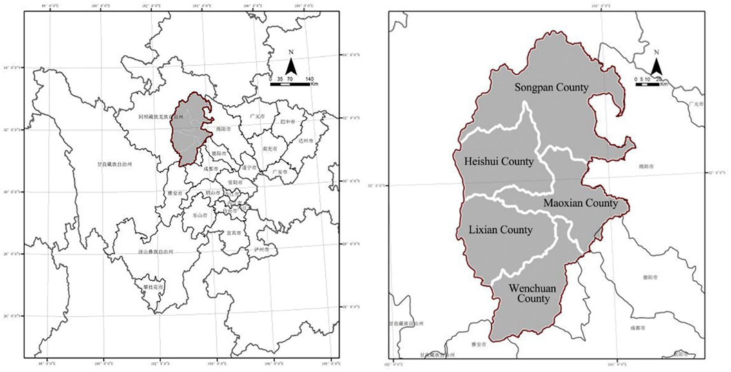
FIGURE 1. The location of core regions in Minjiang wateshed (Source: Author drawing).
The upper reaches of the Minjiang River have a wealth of construction guidance and policy regulations. However, there is a lack of flexible planning guidelines for adapting measures to local conditions and reconciling land use conflicts. It is intended that research focus on improving the development orientation of existing policies. This will mean complementing and improving specific suggestions for specific development areas, and strengthening the feasibility of urbanization implementation. Land conflicts have become more prevalent in the upper reaches of the Minjiang River as a result of urbanization, and man-made activities have destroyed the natural pattern in particular (Li et al., 2016). As a result of our commitment to the protection of the ecological environment, as well as enhancing the quality of life and productivity of the population, the concept of adaptability in this project is both theoretical and practical in understanding how to alleviate and create a harmonious and symbiotic relationship between the two subjects. A unique natural environment and restricted terrain characterize the upper reaches of the Minjiang River. Conflicts over land use have resulted in stagnant urbanization and slow development in this area. It should be noted that this is in comparison with the level of urban construction in the middle and lower reaches of the Minjiang River. A large portion of China’s land area consists of mountains, which have specific structural characteristics. Thus, it is imperative that urbanization development methods be studied within the context of mountain topography for backward areas and areas with obvious differences in spatial characteristics. The environment has suffered severe damage, and the contradictions within the human settlement development system remain unclear. Therefore, it is imperative that we clarify their relationship in order to coordinate their interaction. In particular, we need to clarify the relationship between the construction of human settlements and the ecological environment of the upper Minjiang River. The purpose of this paper is to analyze the current urbanization problems in the upper reaches of the Minjiang River from a material and spatial viewpoint. A mechanism for adapting logic based on relevant evolution logic will be established to explain the relationship between human settlements and ecology. Moreover, the development and construction of urban spaces around watersheds are significant scientific research directions in the field of human settlements. As a result of this research, there is an urgent need to coordinate the development of natural elements with the development of society.
Watersheds have historically been significant sites for human settlement (Wang, 2009; Mao, 2019). A major tributary of the upper Yangtze River (Wang, 2009), the Minjiang River is a crucial source of water and transportation corridor for the Chengdu Plain (Man et al., 2007; Peng et al., 2007). Thus, its environmental conditions influence not only the development of local urbanization, but also the overall development of the Chengdu Plain and the greater Yangtze River basin (Zhang et al., 2014). There is, however, a need to note that the characteristics of the elements in different parts of the basin vary considerably due to the unique ecological environment and topography of the upper Minjiang watershed (Zhao, 2018), and the process of urbanization proceeds slowly. It is necessary to clarify the relationship between human settlement and the ecological environment, as well as the forces that interact between them, in order to formulate a guiding model of the “habitat-ecology” driving mechanism. It is possible to optimize human settlement construction models and propose environmental compensation policies in the watershed by studying the driving mechanisms. Through the integration of theory and practice, this will contribute to the development of targeted environmental protection strategies and land development and utilization methodologies. Analyzing the inadequacies of existing development policies and providing recommendations for developing a “habitat-ecology” coordination model.
To begin with, it is crucial to identify specific elements that reflect human settlements and ecological environments, such as environmental concerns (Fang et al., 2016; Adil et al., 2020); population and water resources. Furthermore, a comprehensive index system must be developed in order to examine habitat-ecology relationships from a rational perspective through data analysis in order to study habitat-ecology relationships more accurately and rationally. As a result, most current studies utilize non-quantitative methods for analyzing data, and the research elements are not comprehensive enough. For example, there is little quantitative research on the upper Minjiang River basin, and even less quantitative research has been conducted on “ecological planning and design” (Pickett et al., 2014), “ecological spatial patterns of towns” (Sun et al., 2014), and “ecological adaptive management methods” (Zhang et al., 2017). It is through the extraction and analysis of these elements that this study provides a deeper understanding of the material and spatial characteristics of the upper Minjiang River basin. Within the scope of this study, an adaptive driving mechanism will be more appropriate and accurate based on the interaction and correlation analysis between these elements. The objective of this approach is to construct optimal combination equations. In order to identify key factors, correlation analysis and regression analysis are used. The purpose of this paper is to provide a more comprehensive analysis of the elements examined. The index system is more appropriate for the upper Minjiang watershed. Additionally, it reveals the interaction between different elements and their effect on each other.
Human settlement construction has always been closely related to urbanization and natural environment protection (National Park Service, 1993; Zhao, 2018). Currently, the allocation of space resources is tense in China, and land conflicts are evident primarily in mountainous and watershed environments (Hu et al., 2007). It is essential to study the behavior of human settlements within the watershed environment under the influence of unique geological and geomorphic conditions. These conditions have a significant impact on improving the quality of human settlements. The most representative studies examine the economic development model of watershed towns, the construction of infrastructure related to water conservation projects, and the concept of building watershed environments from the perspective of disasters within a watershed environment (Zhao, 2009). High-quality human settlement research (Yu and Zhou, 2009). Furthermore, the Songhua River Basin (Sun et al., 2014). Several scholars have also conducted in-depth studies on the utilization of water resources and the corresponding social indicators in foreign countries. (Razzaq et al., 2022a; Razzaq et al., 2022b; Razzaq et al., 2022c).
The Chinese studies primarily focus on the upper reaches of the Yangtze River and its tributaries. Professor Zhao Wanmin of Chongqing University has conducted extensive discussions regarding practical issues such as population relocation and transfer faced by the Three Gorges reservoir area, and has linked reservoir area planning research with urbanization and planning system development. In addition to urban design, historical and cultural heritage protection, and other perspectives (Zhao, 2009). Moreover, Zhao and Zhou conducted corresponding research on the Wujiang River Basin, a second-order tributary of the middle and upper reaches of the Yangtze River, as well as the upper reaches of the Minjiang River from the perspective of comprehensive river basin development and overall planning. A monograph titled “Research on the Construction and Development of human settlements in the Three Gorges Reservoir Area-Theory and practice” examines the assessment and planning of sustainable development, the redistribution of population industries, and urban land use ecology from the perspective of watersheds, urban agglomerations, cities, and blocks. As regards the planning and preservation of historic blocks, the study systematically summarizes the relevant theories pertaining to the construction of human settlements in watersheds and establishes the basic scale and paradigm for watershed research (Zhao, 2018).
With regard to ecologically fragile watersheds, Liu started with small watersheds for soil erosion control, and proposed three different types of residential ecological units for small watersheds on the Loess Plateau: end-of-mountain types, crossing-over river corridor types, and island-surrounded types. Yu discussed the types of human settlements and the evaluation of environmental suitability in the gully area of the Loess Plateau, and defined environmental suitability based on a variety of indicators, including slope and soil type (Yu and Zhou, 2009). It is evident that the relevant research on the human settlement environment in the context of watersheds has always been an important issue in the development of urbanization, and it is also an urban planning challenge that has not been fully overcome in relatively backward areas in various countries. Using the WOS search keywords “Watershed"+"Human settlement"+"Ecological environment”, 331 core literature database results were identified. Citespace software was used to summarize the relevant research over the past 2 decades (as demonstrated in Figure 2), and the international perspective of related research fields is more inclined to examine global climate change from a global perspective. Additionally, domestic development is similar, and many keywords are related to human activities, such as “human impact, commute, human distance”. In terms of research progress, human activities, variability, remote sensing, and climate are the key words for exploration. These key words are followed by climate warming, management, water sedimentation, land use, regions, rivers, biodiversity, classification, ecological services, and water resource development. Approximately one-third of the hot words are related to water, indicating that the level of foreign countries is temporarily higher than that of domestic ones with respect to the exploration of river basins.
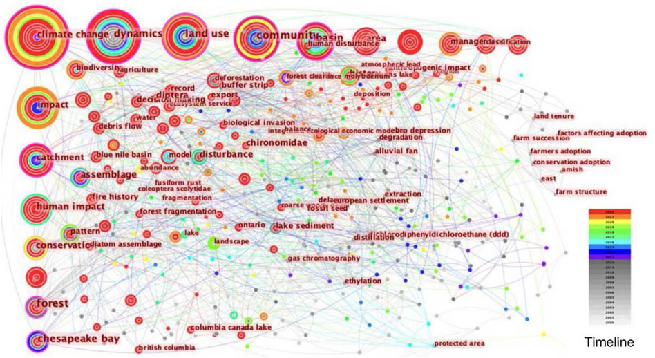
FIGURE 2. Research progress of foreign human settlement in watershed environment.
As can be seen, the sustainable development relationship between watersheds and human settlements provides a model for the continuous construction of various indicators of human settlement and the ecological environment. According to the existing literature, the development of urbanization in a watershed requires consideration not only of the local economy and population, but also of other related variables such as topography, water resource systems, public transportation systems, and infrastructure construction (Sun et al., 2021; Xu, 2022). Consequently, the purpose of this study is to examine the driving relationship between various indicators, and to distinguish their driving roles in the upper reaches of the Minjiang River.
In consideration of the relationship between human settlement construction and the ecological environment. In this paper, the relevant elements of “habitat-ecology” were compiled based on Zhao Bing’s “Ecological Footprint Analysis and Optimization of Habitat in the Upper Minjiang River”, “GIS-based Assessment of Habitat Climate Suitability in Hubei Province” (Zhou et al., 2015), and “Study of Road Skeleton System in Small and Medium-sized Cities” (Wang, 2009). With the assistance of local official websites, it filtered and supplemented these elements. It is intended to make these elements more consistent with the basic characteristics of the upper Minjiang watershed. It is pertinent to note that habitat elements include town construction, transportation systems, watershed economies, and cultural tourism, while ecological elements include “water”, “vegetation”, “weather”, and “topography”. The following elements (Table 1) were used to extract representative indicators to be used as explanatory variables in the later study.
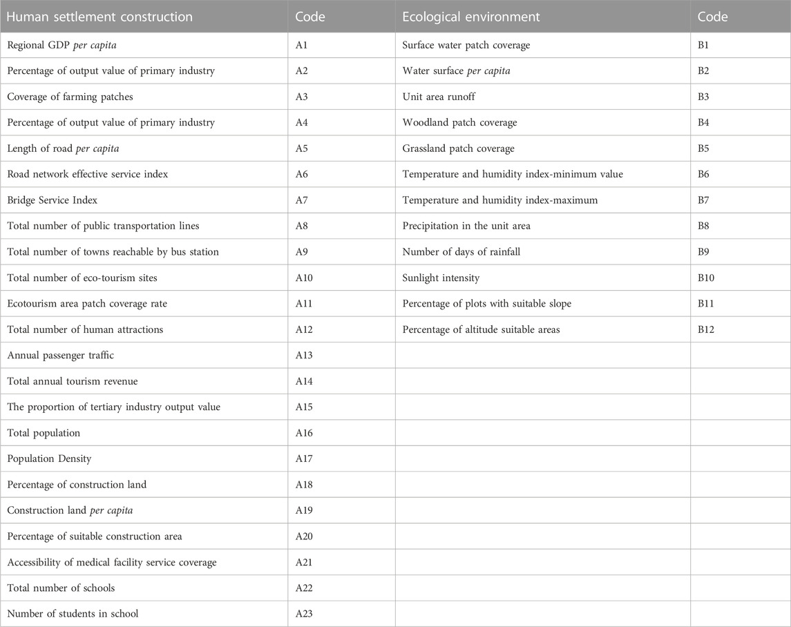
TABLE 1. Summary of explanatory variable system.
Accordingly, 12 samples were selected, including those from Songpan, Mao, Wenchuan, Heshui, and Lixian counties in the upper Minjiang watershed core area and seven comparison samples, namely Jiuzhaigou, Hongyuan, Xiaojin, Ruoerge, and Markang counties in the upper Minjiang watershed radiation area and Dujiangyan and Qing Shen counties in the middle reaches of the Minjiang (Figure 3).
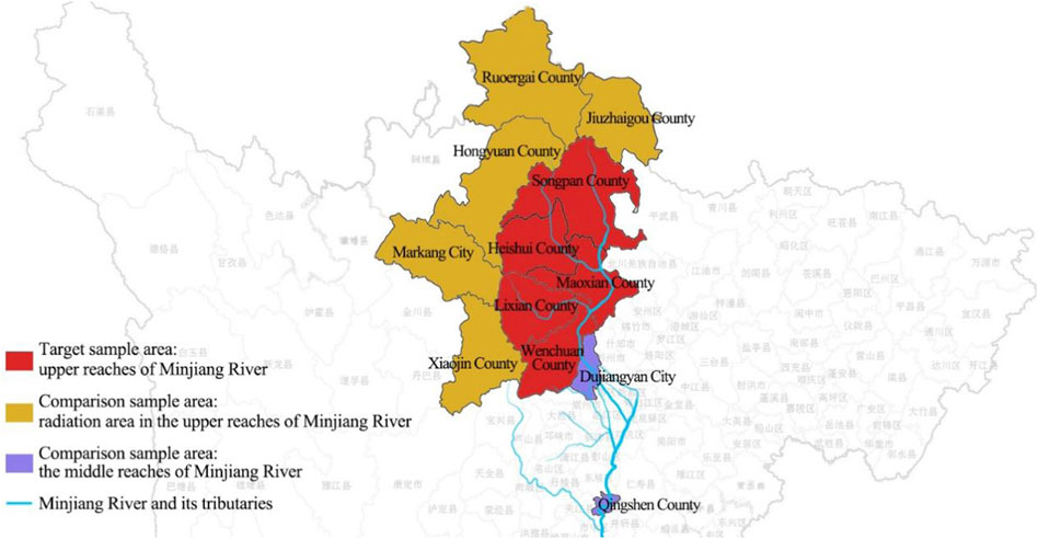
FIGURE 3. The location of sample areas.
(1) Three-dimensional data are gathered from the National Basic Geographic Information Center’s Global Surface Coverage Data Product Service website and the Computer Network Information Center’s Geospatial Data Cloud Platform (Sun et al., 2021), and these vector data are processed and corrected in ArcGIS (Li et al., 2016). (2) Economic index data: data on the economy, such as population, output value, and national economic and social development statistics, are derived from the China County Statistical Yearbook and the National Economic and Social Development Statistical Bulletin. (3) Meteorological data, such as rainfall and runoff, temperature and humidity, and sun intensity. A number of methods have been used to gather these data, including the Central Weather Station, the China Meteorological Data Network, and the “Wheat-A″ tool. A variety of government websites, travel advisory websites, etc., provide information on tourist attractions. A variety of public transportation-related data can be obtained through Xinxin Travel, Baidu Map and other transportation websites. After obtaining the basic data by the above three ways, the different explanatory variables of different sample units are then calculated and assigned.
Using correlation analysis, we can filter out useful variables, which will be synthesized later using three different computational models:
The paper introduces the concept of “deviation coefficient” to describe the variability among the explanatory variables in the study area, i.e., the standard deviation is calculated after normalizing the data for that same variable. For the purpose of this paper,
In Pearson correlation coefficients, the product-difference correlation coefficient is used to assess the linear relationship between two variables, and its value ranges between [-1, 1]. A significant correlation is one in which the absolute value of both variables is greater than 0.6, indicating that there is a strong interaction force between the two variables (Li, 2021). In this equation,
The Spearman correlation coefficient is calculated by using a monotonic equation, which belongs to nonparametric statistics, which has a wide range of application (Xu, 2022). Its value range, principle, and formula are similar to Pearson’s correlation coefficient, which is omitted from this discussion.
There are generally four stages in the regression calculation.
Determine the dependent and independent variables: in the equation, Y is the dependent variable, X is the independent variable, and bi is the adjustment coefficient,
Covariance diagnosis: When more variables are considered, some of the independent variables will have similar explanatory information for the dependent variable, leading to the problem of covariance encountered in multi-factor integrated analysis. It is therefore possible to eliminate unfavorable variables using the variance inflation factor (VIF), which is most effective when VIF <5, and VIF >10 when there is a serious issue of covariance. In this model, (1-R2) represents the tolerance, and Ri represents the negative correlation coefficient of the independent variable Xi for all other variables in the model.
By performing regression calculations, the most appropriate combination of variables can be determined as well as the number of key variables, which should be selected as small as possible. In general, SPSS software allows multiple optimal subsets to be derived (the number is determined by the user). The higher the adjusted R2 value, the better the fit of the optimal subset equation. Where
The importance of each independent variable in the equation is ranked and the respective contribution share is determined based on the results of the regression equation for the optimal subset.
The analysis of the variance of the explanatory variables with the help of the deviation coefficient (
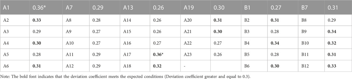
TABLE 2. Coefficient of deviation values of explanatory variables.
In order to determine the preliminary screening results of the explanatory variables, the Pearson correlation matrix should be analyzed (Table 3). In this paper, when the correlation coefficient is greater than or equal to 0.6, it is considered a “significant coefficient”, and when there are more than 10 significant coefficients for a single explanatory variable, it passes the initial screening condition and is considered a “significant variable”. Table 3 summarizes the 20 explanatory variables that meet the conditions. A3, A5, A7, A9, A13, A14, A16, A17, A18, A19, A20, A22, and A23 are human settlement construction categories. The ecological environment construction categories are B1, B3, B5, B6, B7, B8, B12. Among the most significant variables are the total population, population density, per capita construction land, unit area runoff, grassland patch coverage, and the proportion of areas with suitable altitude. This shows that population plays an imperative role in the driving mechanism that is clearly influenced by the ecological environment.
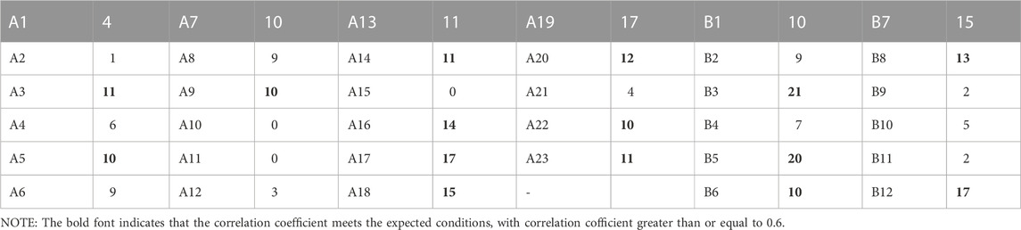
TABLE 3. The number of other explanatory variables with significant correlation in the Pearson coefficient.
Spearman correlation coefficients are calculated and screened in the same manner as Pearson correlation coefficients (Table 4). Accordingly, 14 significant variables have been screened out: the categories of human settlement construction include A3, A6, A7, A17, A18, A19, A21, the ecological environment category, B7, B8, B12, B12, B12. It is more significant, and it can be seen that it is related to “human settlement ecology."
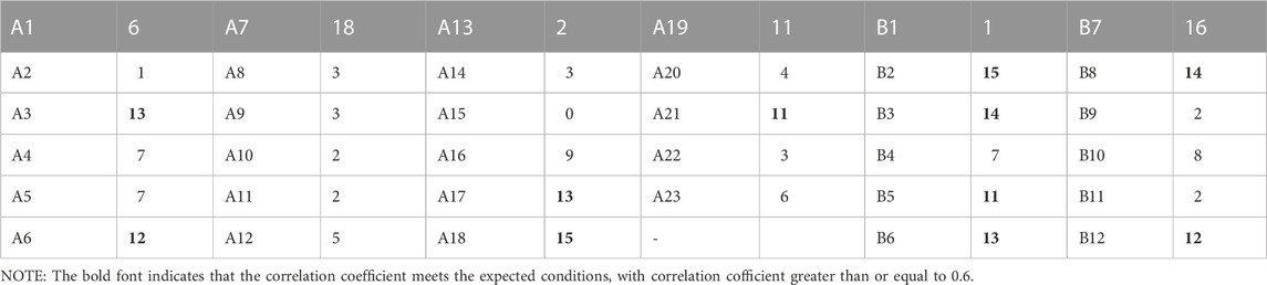
TABLE 4. Spearman coefficients for other explanatory variables with significant correlations.
A study of the differential representation between indicators is conducted in order to clarify the current status of each variable in the county. We compare the results of counties in the upper reaches of the Minjiang River with those of the variable areas, including Songpan (U1), Maoxian (U2), Wenchuan (U3), Heishhui (U4), Lixian (U5), Jiuzhaigou (U6), Hongyuan (U7), Xiaojin (U8), Ruoergai (U9), Maerkang (U10), Dujiangyan (U11), Qingchengshan (U12).
The significant difference in water area per capita (A2) is primarily reflected in Hongyuan County and Ruoergai County. Based on the source data, it appears that the difference in the proportion of water area between the two counties is not obvious. As a result, this variable can also be explained by the fact that the populations of the two counties are clearly low. In Songpan County, Hongyuan County, and Ruoergai County, the value of forest patch coverage (A4) is evidently low. Taking into account the previous analysis, the altitude of these areas is relatively high, which makes it difficult for forests to grow; Shenxian County has a low proportion of forest land. Preliminarily, it can be concluded that the intensity of human settlements is related to the previous data. Temperature and humidity index (A6, A7): The change trend of temperature and humidity index is comparable to that of forest patch coverage, with the exception of Qingshen County, where temperature and humidity will increase as a consequence of its low latitude and heavy rainfall. The number of rainy days is relatively high in the upper reaches of the Minjiang River, but as can be seen from the previous variable, the number of rainy days does not explain the real situation of rainfall in this area.
Sunlight intensity (A10): The sunshine intensity is obviously higher in the radiated areas of the upper reaches of the Minjiang River, and most of these areas are within the plateau zone. As with the change pattern of sunshine intensity, this variable reflects the proportion of plots with a suitable slope (A11). However, there are large basins, plains, or hilly terrain in the middle reaches of the Minjiang River, and the slope is relatively gentle. Suitable altitude (A12) refers to areas with lower altitudes, since these areas are more suitable for human settlements. The figure indicates that this parameter is generally low in the upper reaches of the Minjiang River, while it has improved significantly in the middle reaches. This indicates that the Minjiang River’s upper reaches have a higher elevation than its middle reaches. Regional per capita GDP (B1): Some counties in the upper reaches of the Minjiang River have low per capita GDP, but Wenchuan County and Li County have significantly higher per capita GDPs than other counties. There is no significant geographical preference for the proportion of employees in secondary and tertiary industries (B2), although there are significant differences among counties in this variable; Hongyuan County, Xiaojin County, and Ruoergai County have the lowest parameter values among them. In the upper reaches of the Minjiang River, the primary industry represents a relatively high proportion of output value (B4), particularly in Hongyuan County and Ruoergai County; however, it is less apparent in the middle reaches of the Minjiang River.
As can be seen from the figure, the Road Network Effective Service Index (C2) in Heishui County and Zoige County is low, while the values in Mao County, Wenchuan County, Li County, and the middle reaches of the Minjiang River are relatively high. The Bridge Service Index (C3) is generally higher in the upper reaches of the Minjiang River (except in Wenchuan), that is, the average distance between two bridges is larger, which indicates that the distance between two bridges in this basin is relatively long. The differential screening did not reveal any significant differences between the cultural and tourism landscapes. A study of two variables with relatively large differences was conducted in order to gain a better understanding of the phenomenon. Eco-tourism patch coverage (D2): Although this parameter varies greatly, it does not indicate a clear preference regarding the research area; Hongyuan County and Dujiangyan City appear to be the most prominent. The total number of cultural attractions (D3) is relatively low in the radiation area of the upper reaches of the Minjiang River. According to the previous data, this area is mainly characterized by ecological and natural landscapes. Although there is a significant difference in population density (E2), it is primarily reflected in the differences between the upper and middle reaches of the Minjiang River; while for the upper reaches, there is no obvious difference.
There is a similar pattern of change in the proportion of construction land (E3) and suitable construction area (E5), indicating that these two variables are closely related to population density. As can be seen from the figure, even though the algorithm for calculating the proportion of suitable construction areas is relatively objective, its potential impact on population density and the scope of human settlements can be seen. Construction land per capita (E4) is significantly higher in the upper reaches of the Minjiang River, which also indicates that the intensity of construction and human activities is relatively low in this area, and urbanization is not as good as in the middle reaches. Accessibility to medical facilities and service coverage (E6): This parameter is significantly lower in the upper reaches of the Minjiang River, and the higher value of Malkang City can be attributed to its status as a county-level city; it may reflect medical care in a certain way in the upper reaches of the river. Low infrastructure configurations are present. As a result of the above analysis, it is evident that some differentiated variables exist objectively, some are artificially produced, and some are caused as a result of these objective variables.
The three calculation methods have been applied to obtain their respective significant variables. This paper refers to significant variables with occurrence times ≥2 as “characteristic variables” (Table 5). The following text uses these Features variables as independent variables. Table 5 shows that there are 14 characteristic variables, which are A3, A6, A7, A17, A18, A19, A20, A21, B2, B3, B5, B6, B8, B12.
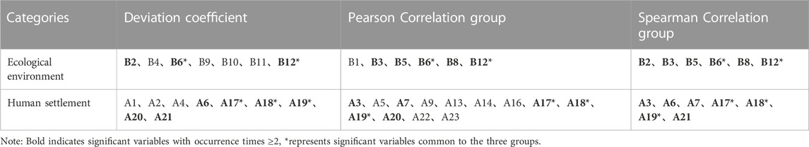
TABLE 5. The determination of characteristic variables.
In this study, the dependent variable is chosen from the characteristic variables. The construction of human settlements is the main focus, so the dependent variable is selected from the categories of human settlements. The following eight feature variables are included in this category: A3, A6, A7, A17, A18, A19, A20, and A21. Further, A6 and A7 have overlapping definitions, and the latter is generally incorporated in the former, so A7 is omitted. It is possible to calculate A19 from A17, A18 and A19, so there will be some repetition in the analysis. Therefore, we do not include A19 in the analysis. In the following regression analysis, A21 cannot calculate the optimal equation model, so it is not considered. To sum up, A3, A6, A17, A18 and A20 were selected as dependent variables.
A variance expansion coefficient greater than 10 indicates that the variance ratios meet the requirements when optimizing the variable combination using collinearity diagnosis. Even though the VIF is greater than 5, a small number of variables are retained at this time. To facilitate Modeling, the dependent variables will not be further eliminated. With the condition of flexible screening, there are two conditions for passing the collinearity diagnostic screening: “VIF<10″and “variance ratio<0.9". Based on the results of the collinearity diagnosis, the independent variables of A7, A19, A21, B2, B3, B5, and B12 performed relatively well (Table 6).
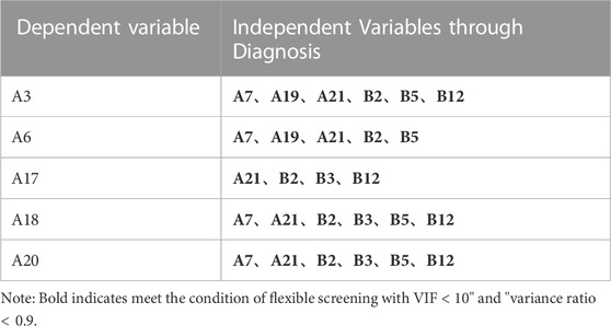
TABLE 6. Collinearity Diagnostic Results.
As a result of performing optimal subset regression, the optimal output model can be derived for each dependent variable. “Accuracy (R2)" and “Residual Histogram” are used to evaluate whether the fitting result is satisfactory. The accuracy of the model reaches 70% (that is, the R2 has been adjusted to a value of over 0.7) and the residual histogram fits well with the histogram, suggesting that the model is well fitted. According to the output results (Table 7), the optimal subset regression equations for the dependent variables A3, A17, A18, and A20 fit well, while the model for the A6 variable fits poorly. Therefore, the optimal subset regression equations are A3*A19 + A21 + B5+B12, A17*B2+B3+B12, A18*A7+B3+B5+B12 and A20*A7+B3+B5+B12.
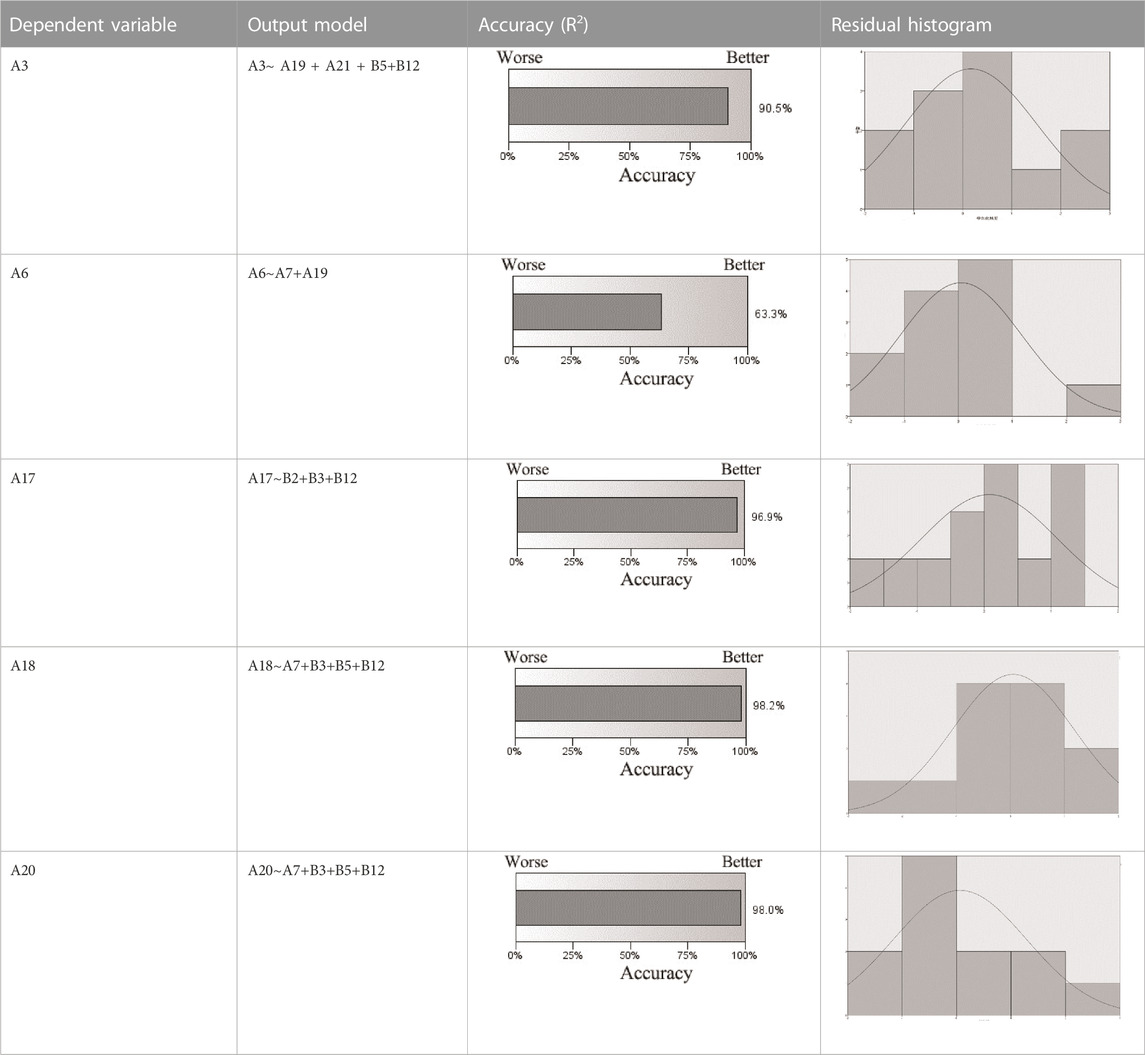
TABLE 7. Optimized output model and optimal subset regression equation.
Due to the fact that many studies have been conducted on the upper reaches of the Minjiang River, the conclusions of this study are similar to those of other scholars. For example, the measured changes and fluctuations of the “grassland” element in human activities are relatively large (Hu et al., 2007). Also, a wealth of documents pay more attention to the methods of data collection, rather than identifying the categories of usage for urban development (Tahir et al., 2021). As a result, no systematic index structure has been formed for the relevant spatial and material elements in the watershed environment. Several Chinese scholars have already paid attention to the development of the upper reaches of the Minjiang River 10 years ago (Zhao, 2009; Zhao, 2018). At that time, however, due to the lack of technology and the limited scope of research, many problems emerged in the implementation of the conclusions, including the overexploitation of the environment, the disordered road structure, and scattered villages. With the assistance of current research ideas and technologies, we believe we should begin to review and examine the changes in the upper reaches of the Minjiang River. Therefore, we extracted and utilized variables again. It should be noted, however, that the specific research obtained in this paper is more diverse than any other literature. This is because there are differences in research directions, ideas, and sample areas. In addition, there is a more extensive level of exploration of indicators, as well as the systematic integration of various explanatory variables in the upper reaches of the Minjiang River.
Chinese scholars are increasingly focusing more on the exploration of similar cases, such as establishing the element construction mechanism of the watershed environment from a single perspective (Guo et al., 2013; Li et al., 2016). Investigate the changing principles of social activity and ecological adaptability based on the construction of human settlements. It is interesting to note that in the related studies of watersheds, the exploration of adaptation reveals more in-depth conclusions. The potential for urbanization in a watershed can be determined, for example, by surveying the suitability of land development. The construction of large-scale villages in the vicinity of small watersheds (Mao, 2019). Watershed boundary and town size development relationship (Zhang et al., 2017). In light of the fact that the purpose of this study of variables and influencing mechanisms involves the combination of other disciplines, it can be seen that the results of the study will be enhanced when the research purpose of the watershed involves combining other disciplines. The systematic establishment of the impact mechanism structure can provide insight into the development relationships of elements, which can serve as a foundation for further research in this area. As a result of examining multiple elements and exploring the relationships between them, this article establishes 35 variable systems, which cover all aspects of human settlements and the environment. In the human settlement environment, it has been determined that “population density” and “proportion of construction land” are more prominent, and the former has 17 highly correlated variables, while the latter can reach 15; and among the eco-environmental factors, the factors that are relatively prominent include “per capita water area”, “unit area runoff”, “grassland patch coverage”, and “proportion of areas suited to altitude".
As can be seen in the above optimal subset regression equation, each dependent variable is composed of a number of independent variables. The “contribution rate” represents the degree to which independent variables influence the dependent variable. The greater the significance of the independent variable, the larger and more obvious the contribution rate will be. According to the results (Figure 4), the contribution rate of B12 is the highest, exceeding 70% regardless of which model is used. Therefore, the altitude factor can have significant effects on the “human settlement-ecology” relationship in the upper reaches of the Minjiang watershed. It is worth noting that other variables with a higher contribution rate are B3, B5 and A7, in addition to the three variables A19, A21 and B2. These variables, although their contribution rates are small, can still produce better interactions than other explanatory variables.
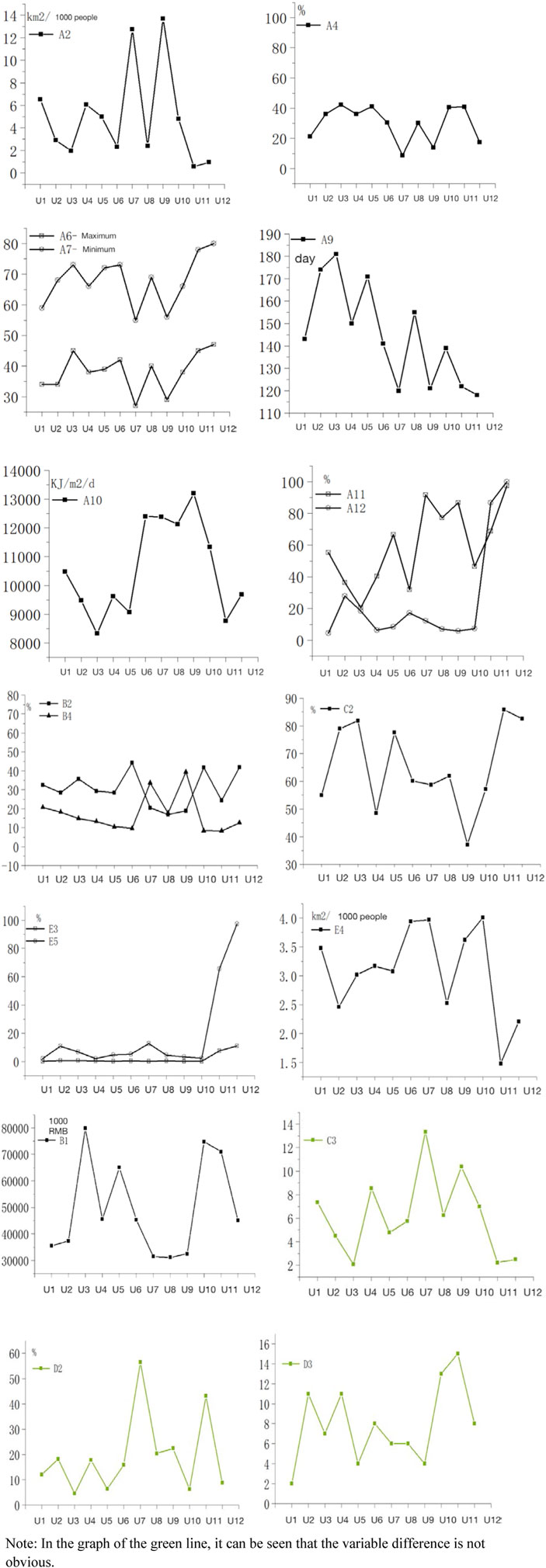
FIGURE 4. (Continued)
Based on the previous data calculation results, the interaction force between the explanatory variables has been calculated. On the basis of the data results, and referring to the characteristics of the upper reaches of the Minjiang watershed, the relationship between “human settlement construction and ecological environment driving mechanism” can be analyzed as follows: The human settlement environment acts on the construction of the ecological environment, and when the ecological environment bears the excessive “load” of the construction of human settlements, it reacts to the human settlement environment. The following is a detailed analysis of the human settlement environment as the driving force and the ecological environment as the carrying capacity (Figure 5).
(1) In light of the above data analysis, it is evident that population density, construction land, and medical facility service scope are the most significant driving forces in the model of the driving mechanism. Therefore, these factors constitute the primary driving force. A major driving force is the distribution of the road network and the construction of bridges. Furthermore, there are factors such as farm patch coverage and industrial composition ratio, which are considered to be basic driving factors. However, the Pearson correlation coefficient indicates that annual passenger flow and tourism revenue perform better, so they are considered as auxiliary driving factors.
(2) An analysis of the carrying capacity-ecological environment has shown that the factor of “proportion of suitable altitude areas” has a strong independent significance, which is the basis for this paper’s study of the driving mechanism model. Furthermore, ecological environment variables such as per capita water surface, runoff per unit area, and grassland patch coverage have also been included in the optimal equation model, indicating that they will undergo obvious changes due to human settlement construction; as a result, they will serve as the main carrying capacity. Moreover, the temperature-humidity index and unit area precipitation that have passed the correlation test can also be used as basic carrying capacities. Although to some extent, the five variables in the ecological environment, surface water patch coverage, woodland patch coverage, rainfall days, sunlight intensity, and proportion of suitable slopes, failed the correlation test, they remained significant to some extent. Consequently, they can be viewed as an auxiliary carrying capacity in this mechanism model, since they are influenced by the development of human settlements. Figure 6
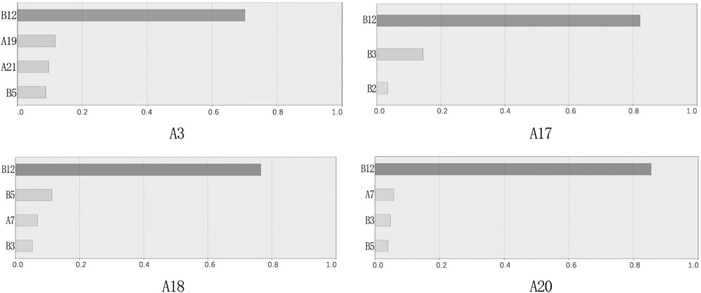
FIGURE 5. The independent effects of explanatory variables.
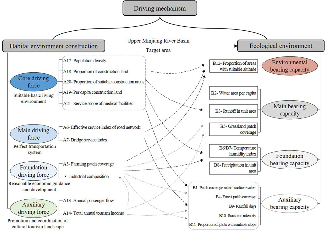
FIGURE 6. “Habitat-ecology” driving mechanism model.
Human settlements and ecology in the upper reaches of the Minjiang watershed are influenced by factors such as altitude, population, and construction land. Altitude has a strong impact on agricultural land, population density, construction land, the traffic network, and precipitation. Population density primarily relates to water distribution, altitude, precipitation, agricultural land, and construction land. The state of construction land will have potential impacts on traffic, vegetation distribution, and runoff.
In the upper reaches of the Minjiang watershed, the “human settlement-ecology” driving mechanism is influenced by a combination of factors. Several key elements are involved in this mechanism, such as altitude, population, construction land, etc. In contrast, each element has its own combination of influences. In the case of “construction land”, its combination of influence factors is “bridge traffic + runoff + grassland distribution + altitude".
It is of great importance for urbanization and development in the context of watersheds to study how elements interact with the ecological environment. At present, China’s urbanization is undergoing rapid growth, and it has transitioned from a spatially diffuse to a highly intensive development model. Considering the ecological environment, the construction concept of sustainability, environmental protection, and living balance is highlighted. In contrast to plain areas, watershed areas are still in the early stages of urbanization due to the influence of mountain altitudes and extreme weather conditions. In recent decades, a number of scholars have continuously explored how to conduct urban planning and design in such areas, achieving impressive results in the process. However, as a result of the constant changes in policies and the evolution of population needs, relevant research has been constantly re-examining the status quo of the watershed, particularly in regard to environmental variables. However, the mechanism of action and the corresponding model between the elements have not been systematically constructed. Therefore, in addition to constructing the index system and researching the driving mechanism based on the current situation, the research in this paper also proposes the extraction path of urban elements and variables within the research basin to provide a reference for future studies in this area.
It is emphasized in this paper that variables are extracted and relationships are explored between material and spatial elements. There has, however, been no effective interpretation of the interaction between human activities within the watershed and the related cities. There is no doubt that we have not studied the environmental impacts of population growth and decline and whether there are corresponding countermeasures. As a result, in future research, more dynamic research strategies will be proposed. Moreover, this study has not yet proposed the model for urban design based on the findings of this study, but only focuses on the driving relationship between the various elements. In the future, a follow-up study will be conducted.
The original contributions presented in the study are included in the article/supplementary material further inquiries can be directed to the corresponding author.
BL: Conceptualization, Methodology, Validation, Writing—original draft, Writing—Editing, Investigation, Data curation, Funding acquisition. ZW: Conceptualization, Methodology, Validation, Data curation. JH: Validation, Data curation, Investigation. JW: Data curation, Investigation. JS: Supervisor.
This work was supported by Natural Science Foundation of China, Chongqing (stc2021jcyj-msxmX0293).
The authors would like to acknowledge the support provided for this research by the Sichuan Provincial Architectural Design and Research Insititute for documents sharing.
Author JW was employed by the Da Sheng Assert management group Co., Ltd.
The remaining authors declare that the research was conducted in the absence of any commercial or financial relationships that could be construed as a potential conflict of interest.
All claims expressed in this article are solely those of the authors and do not necessarily represent those of their affiliated organizations, or those of the publisher, the editors and the reviewers. Any product that may be evaluated in this article, or claim that may be made by its manufacturer, is not guaranteed or endorsed by the publisher.
Adil, S., Sara, B., and El, O. B. (2020). Impacts and social implications of landuse-environment conflicts in a typical Mediterranean watershed. Sci. Total Environ. 764, 142853. doi:10.1016/j.scitotenv.2020.142853
Fang, C. L., Zhou, C. H., Gu, C. L., Chen, L. T., and Li, S. C. (2016). A theoretical framework and technical path to analyze the interactive coupling effect of urbanization and ecological environment in mega-city cluster areas. J. Geogr. 71 (04), 531–550.
Guo, B., Tao, H. P., Jiang, L., Shi, Z., and Song, C. F. (2013). Evaluation of ecological habitability of the upper Minjiang River under natural disaster stress. Soil Water Conservation Bull. 33 (01), 124–128+138. doi:10.13961/j.cnki.stbctb.2013.01.020
Hu, Z. B., He, X. Y., Li, Y. H., Zhu, X. J., and Li, S. Y. (2007). Analysis of landscape changes in the upper Minjiang River under the influence of human activities. J. Ecol. 5, 700–705.
Li, J. (2021). Research on the influence of urban green space landscape pattern, eco-social effects on public environmental perception and driving mechanism. Shanghai Normal University. doi:10.27312/d.cnki.gshsu.2021.002425
Li, M. J., Yang, B., Zhan, J. F., Gao, G. S., and Wang, S. J. (2016). GIS-based land use/cover change study in the upper Minjiang River basin. Surv. Mapp. Eng. 25 (06), 41–45. doi:10.19349/j.cnki.issn1006-7949.2016.06.010
Man, Z. Z., Su, C. J., Xu, Y., Liu, X. L., and Zhang, J. Y. (2007). Problems and countermeasures in the Minjiang upper reaches of the fallow forest project. Anhui Agric. Sci. 3, 825–826. doi:10.13989/j.cnki.0517-6611.2007.03.097
Mao, Q. Z. (2019). Theory and practice of the science of human settlements in China. Int. Urban Plan. 34 (04), 54–63. doi:10.22217/upi.2019.198
National Park Service (1993). Guiding principles of sustainable design. New York: National Park press.
Nick, B., Neil, W. A., and Mick Kellyc, P. (2005). The determinants of vulnerability and adaptive capacity at the national level and the implications for adaptation. Glob. Environ. Change 15 (15), 151–163. doi:10.1016/j.gloenvcha.2004.12.006
Peng, L., Su, C. H. J., Xu, Y., and Man, C. Z. B. (2007). The current situation, problems and management measures of the ecological environment in the upper reaches of Minjiang River. J. Jiangxi Agric. Univ. Soc. Sci. Ed. 1, 80–84. doi:10.16195/j.cnki.cn36-1328/f.2007.01.019
Pickett, S. T. A., Cadenasso, M. L., and McGrath, B. P. (2014). Resilience in ecology and urban design. China: Springer Verlag.
Razzaq, A., Liu, H., Zhou, Y., Xiao, M., and Qing, P. (2022a). The competitiveness, bargaining power, and contract choice in agricultural water markets in Pakistan: Implications for price discrimination and environmental sustainability. Front. Environ. Sci. 10, 917984. doi:10.3389/fenvs.2022.917984
Razzaq, A., Xiao, M., Zhou, Y., Anwar, M., Liu, H., and Luo, F. (2022b). Towards sustainable water use: Factors influencing farmers’ participation in the informal groundwater markets in Pakistan. Front. Environ. Sci. 10, 944156. doi:10.3389/fenvs.2022.944156
Razzaq, A., Xiao, M., Zhou, Y., Liu, H., Abbas, A., Liang, W., et al. (2022c). Impact of participation in groundwater market on farmland, income, and water access: Evidence from Pakistan. Water 14 (12), 1832. doi:10.3390/w14121832
Shi, Y. Q. (2005). Research on the evaluation system of road skeleton system in small and medium-sized cities. China: Xi'an University of Architecture and Technology.
Sun, H. T., Zhang, L. L., and Cai, X. D. (2014). Planning and construction of ecological spatial pattern of typical cities in the Songhua River basin. J. Archit. 2014 (S1), 138–142.
Sun, Y. W., Wang, R., Guo, Q. H., and Gao, C. (2021). Spatial and temporal variation of urban heat island intensity in China and its driving factors based on habitat scale. Environ. Sci. 42 (01), 501–512. doi:10.13227/j.hjkx.202006009
Tahir, M. A., Ma, D., Erfanian, S., and Ziaullah, M. (2021). How does justice matter in developing supply chain trust and improving information sharing - an empirical study in Pakistan. Int. J. Manuf. Technol. Manag. 35 (4), 354. doi:10.1504/ijmtm.2021.10045370
Tension, Y. (2018). Research on the optimization of town system structure in the upper Minjiang River basin based on water resources carrying capacity. China: Southwest University for Nationalities.
Wang, X. C. (2009). A review of foreign integrated watershed planning. Changjiang Publishing House. doi:10.16232/j.cnki.1001-4179.2010.08.008
Xu, J. (2022). Comparative study on the coordination of urban habitat environment and economic growth--a multivariate analysis based on 36 key cities. J. Yunnan Univ. Finance Econ. 38 (01), 12–24. doi:10.16537/j.cnki.jynufe.000753
Yang, B., Zhan, J. F., and Li, M. J. (2014). Environmental vulnerability assessment of the upper Minjiang River basin. Remote Sens. land Resour. 26 (04), 138–144.
Yu, C. L., and Zhou, R. Q. (2009). Type and environmental suitability evaluation of habitat environment in small watersheds in the gully area of Loess Plateau. New Archit. 2, 74–78.
Zhang, J., Guo, X. J., Chen, T. F., Chen, X. C., Sun, I. Q., and Li, S. (2021). A preliminary study on the calculation method of flooding in small watersheds in Wenchuan earthquake area. J. Nat. Hazards 30 (01), 155–164. doi:10.13577/j.jnd.2021.0116
Zhang, L. L., Zhao, Y. H., Yin, S., Fang, S., Liu, X. J., and Pu, M. M. (2014). Landscape pattern gradient analysis of the Minjiang Arid River Valley based on the moving window method. J. Ecol. 34 (12), 3276–3284.
Zhang, Z. Y., Li, F., Xu, C., and Li, S. (2017). A study on the adaptive management method of urban composite ecology--a case study of Zengcheng District, Guangzhou City. Environ. Prot. Sci. 43 (01), 105–110. doi:10.16803/j.cnki.issn.1004-6216.2017.01.022
Zhao, B. (2018). Ecological footprint analysis and habitat optimization study of the upper reaches of Minjiang River. Beijing: Science Press.
Zhao, B. (2009). Sensitivity analysis and post-disaster reconstruction of vulnerable ecological environment in the upper Minjiang River towns. J. Southwest Univ. Natl. Nat. Sci. Ed. 34 (01), 165–169.
Keywords: human settlement construction, ecological environment, driving mechanism model, correlation analysis, regression analysis
Citation: Liao B, Wang Z, He J, Wu J and Su J (2023) The driving mechanisms for human settlement and ecological environment in the upper minjiang watershed, China. Front. Environ. Sci. 11:1097801. doi: 10.3389/fenvs.2023.1097801
Received: 14 November 2022; Accepted: 30 January 2023;
Published: 20 February 2023.
Edited by:
Zeeshan Fareed, Huzhou University, ChinaReviewed by:
Muhammad Aamir, Huanggang Normal University, ChinaCopyright © 2023 Liao, Wang, He, Wu and Su. This is an open-access article distributed under the terms of the Creative Commons Attribution License (CC BY). The use, distribution or reproduction in other forums is permitted, provided the original author(s) and the copyright owner(s) are credited and that the original publication in this journal is cited, in accordance with accepted academic practice. No use, distribution or reproduction is permitted which does not comply with these terms.
*Correspondence: Jiafu Su, amlhZnUuc3VAaG90bWFpbC5jb20=
Disclaimer: All claims expressed in this article are solely those of the authors and do not necessarily represent those of their affiliated organizations, or those of the publisher, the editors and the reviewers. Any product that may be evaluated in this article or claim that may be made by its manufacturer is not guaranteed or endorsed by the publisher.
Research integrity at Frontiers
Learn more about the work of our research integrity team to safeguard the quality of each article we publish.