 Xiang Luo
 Jingjing Qin
 Chao Cheng
 Yue Pan2*
 Tiantian Yang
- 1School of Public Administration, Central China Normal University, Wuhan, China
- 2School of Civil Engineering and Architecture, Wuhan Institute of Technology, Wuhan, China
To integrate the concept of high-quality development into urban land use, this paper explores the spatial-temporal pattern characteristics of urban land intensive use (ULIU) in the Yangtze River Delta with a constructed evaluation index system, the comprehensive evaluation model and exploratory spatial data analysis based on the spatial panel data of 41 cities from 2010 to 2020. The paper also analyzes the spatial effects and influencing factors of ULIU with the spatial Durbin model and partial differential method. The results demonstrate that: 1) The ULIU in the Yangtze River Delta generally showed consistent growth from 2010 to 2020. However, there was significant spatial differentiation among different regions, as the land intensive use level was higher in cities along the Yangtze River and coastal cities around Hangzhou Bay, while relatively lower in the mountainous and hilly cities in Zhejiang and southwestern Anhui. 2) The ULIU level showed significant positive global spatial autocorrelations, while its local spatial characteristics mainly included four types dominated by high-high agglomeration and low-low agglomeration from 2010 to 2020. 3) Economic development, industrial structure and infrastructure could remarkably promote the ULIU of both local and neighboring cities. Scientific and technological innovation could significantly enhance the ULIU of local cities; population urbanization and government financial pressure showed significant negative effects on the ULIU of local cities; while all the above three factors had insignificant effects on the ULIU of neighboring cities. These findings are of great significance for revealing the internal mechanism underlying the spatial effect of land intensive use and provide some guidance for improving the level of ULIU in the Yangtze River Delta from the perspective of regional cooperation.
1 Introduction
High-quality development is an inevitable option to realize sustainable urban development under the constraint of resources and environment (Zhang et al., 2019). In 2017, China government proposed to transform high-speed economic development to high-quality economic development, and thereby the concept of high-quality development has influenced all aspects of economic and social transition. Since land is an important spatial carrier of urban economic and social activities, the establishment of an intensive, green and efficient land space is the basic prerequisite for high-quality development and construction of “beautiful China” in the new era (Yang et al., 2020a). The urbanization rate of permanent population in China had reached 64.72% at the end of 20211. With the continuous acceleration of urbanization, the conflict between the demand and supply of urban land resources has become increasingly prominent. The continuous agglomeration of population, capital and other factors into cities drives the rapid expansion of urban construction land, which is accompanied by dramatic decreases in agricultural and ecological space and greater pressure on natural environment (Luo et al., 2020). As a matter of fact, urban construction land use is relatively extensive in most cities, and 15%–30% of the land in built-up areas is still in an inefficient or idle state (Fang and Ma, 2013). The construction land has low economic and social output and huge resource consumption, pollution and emissions, which is not conducive to the high-quality development of cities. For a long time, Chinese government has paid great attention to the intensive use of land and has issued a series of related guidelines and regulation policies (Luo et al., 2021). The Suggestions on Construction Supervision and Implementation of a Land Spatial Planning System in 2019 clearly proposed to define the spatial boundaries such as ecological redline, permanent basic farmland and urban development boundary, to enhance the constraint of the bottom line and reserve space for sustainable development. Urban development boundary has become a control bottom line for the disorderly expansion of urban construction land, forcing local governments to stimulate the potential of existing land and achieve efficient and intensive use of urban construction land (Pan et al., 2017). In the context of territory development planning, the combination of high-quality development concept and urban land intensive use is critical for guiding the smart growth and realizing sustainable development of cities. High-quality development emphasizes innovation, coordination, greenness, openness and sharing. Among them, green development is fundamental. We should transform the traditional mode that only pays attention to economic benefits and ignores ecological and social benefits. Therefore, high-quality intensive use of land can be defined as a land use mode that implements the development concept of economy, efficiency, greenness and sharing in the process of land use, which can save land resources, and obtain economic, social and ecological benefits through scientific factor input.
Research on urban land intensive use has been a hot topic in academic community. The existing research has been mainly focused on the following five aspects. 1) Regarding the connotation of land intensive use, researchers generally believe that land intensive use is different from economical land use. Economical land use emphasizes the effect of land use, while land intensive use lays more emphasis on the ways of land use (Liu et al., 2006; Li et al., 2009). Land intensive use is to obtain higher outputs by increasing the inputs on existing land (Wang et al., 2017), and the outputs are usually measured by the use efficiency and economic benefits of the land (Lin et al., 2009). From the perspective of sustainable and green development, some scholars believe that the output of land intensive use should be evaluated comprehensively from economic, social and ecological aspects (Sun et al., 2015). 2) As for the evaluation of ULIU, most researchers proposed multi-factor evaluation systems involving land input level, utilization intensity, utilization efficiency, and utilization structure (Song et al., 2015; Tan et al., 2018) based on the conceptual connotation of land intensive use, and employed the comprehensive evaluation model, principal component analysis (Zhu and Cao, 2011), and stochastic Frontier model (Xu et al., 2021) to quantitatively evaluate the intensive use level of urban land. In addition, Xiong et al. (2017) and Wei et al. (2017) introduced the methods such as system dynamics and matter element analysis model into the measurement and evaluation of land intensive use, while Wang et al. (2019) proposed a model to evaluate land intensive use potential based on technical efficiency measurement. All these methods have greatly enriched the methodology for evaluating ULIU. With the diversification of quantitative analysis methods, many empirical studies have been carried out at the national (Yang et al., 2016), city cluster (Wang et al., 2010), provincial (Ye et al., 2015), microscopic city (Yang et al., 2012) and industrial park (Wu et al., 2020) levels. Besides, the spatio-temporal evolution characteristics of ULIU level have been explored in different dimensions and regions. 3) ULIU and other urban systems interact with and constrain each other. From the perspective of system theory, ULIU has coupling and coordinated development relationships with other systems such as city size (EddieHui et al., 2015), new urbanization (Li et al., 2017; Zhang et al., 2018), economic and social development (Gong, 2013), industrial structure (Zhang and Weng, 2022), carbon emissions (Wang, 2020), urban land price (Liang et al., 2019), and ecological security (Cen et al., 2015). In addition, ULIU has been found to have significantly positive effects on economic development (Yang, 2020), carbon emission efficiency (Xie et al., 2018), air pollutant emission (Liang et al., 2018), urban land expansion (Zhu et al., 2020), and transportation (Zhao et al., 2021). 4) It has been revealed that ULIU is affected by various including society, economy, nature and policy, such as the scale and structure of urban system, economic development level, urbanization level, industrial structure level and highways (Li et al., 2016; Zhao and Hu, 2016; Zhang et al., 2020; Liu et al., 2021; Pratama et al., 2022). 5) In addition, with the maturity and wide application of spatial measurement methods, the research on spatial spillovers of land intensive use has gradually received great academic attention. Previous studies have shown that land intensive use has significant spatial dependence and proximity radiation effects in China (Peng et al., 2014). In addition, some scholars have explored the spatial spillover effect of transportation networks (Zhao et al., 2020), ecological networks (Yang et al., 2020b), economic structure differences (Peng et al., 2017), urbanization quality (Fan et al., 2018), and producer service industry (Zhou and Tan, 2016) on intensive urban land use from the spatial geography perspective by means of spatial econometrics. In general, the concept and connotation, evaluation methods and influencing factors of ULIU have been extensively explored. However, most studies evaluated the land intensive use level from the perspective of input strength and economic efficiency, which have largely left the economic and ecological use of land out of the picture, as well as ignored the social benefits of land intensive use. Therefore, these studies have generally failed to comprehensively reflect the high-quality connotation of ULIU.
In consideration of the above analysis, this paper firstly constructs a comprehensive evaluation index system to measure the ULIU level in the Yangtze River Delta based on the concept of high-quality development by reference to existing related literature. Secondly, the kernel density estimation, trend-surface analysis, GIS visualization and exploratory spatial analysis are applied to systematically study the spatio-temporal evolution characteristics of ULIU in the Yangtze River Delta. Furthermore, the spatial panel Durbin model is used to analyze the influencing factors and the spatial effect of ULIU. Finally, some policy recommendations are proposed based on the research findings. The study aims to provide a methodological reference for revealing the influencing factors on ULIU and the internal mechanism underlying its spatial effects, as well as provide implications for the decision making to promote the efficiency and intensity of urban land use and for optimal allocation of land resources in the Yangtze River Delta.
2 Research area and data sources
2.1 Research area
The Yangtze River Delta is an important node of the Yangtze River Economic Belt as well as a significant functional area to support and lead the regional economic development in China. According to the “Yangtze River Delta Regional Integrated Development Plan” issued at the end of 2019, the Yangtze River Delta Region covers three provinces (Jiangsu, Zhejiang and Anhui) and one municipality (Shanghai), including a total of 41 cities. This region is the most highly urbanized with dense distribution of cities and towns in China, with a total land area of 358,000 km2, and accounts for about 3.7% of the land area as well as about 25% of total economic output and about 16% of permanent population in China. By the end of 2020, the urbanization rate of the Yangtze River Delta had reached 70.85% and the regional GDP reached 24.47 trillion RMB. The convergence of population, land, and capital in cities had boosted the continuous outward expansion of urban construction land. According to the statistical data of China Urban Construction Statistics Yearbook, the total area of urban construction land in 41 cities of the Yangtze River Delta was increased by nearly 40% from 7,222.74 km2 in 2010 to 10,051.70 km2 in 2020. The dramatic increase in urban construction land calls for the promotion of land use intensity in these cities. Therefore, with the transformation from high-speed urbanization to high-quality urbanization, it is extremely necessary to study the land intensive use level in this region. In addition, due to the high regional integration level regardless of great differences in development conditions and economic levels between cities in this region, exploration of the spatial and temporal effects of land intensive use and its influencing factors can provide important implications for formulating more accurate policies for land resource allocation.
2.2 Data sources
This paper selects data on land intensive use level in 41 cities of the Yangtze River Delta from 2010 to 2020 for the study. All data and indicators were obtained from the China City Statistics Yearbook, the China City Construction Statistics Yearbook and statistical yearbooks and statistical bulletins of various provinces and cities in the Yangtze River Delta. Individual outliers and missing data were replaced by mean values of adjacent years or their provinces. The data of administrative regional boundaries at all levels were obtained from the 1:4,000,000 national basic geographic information database (https://www.resdc.cn). The latitude and longitude data of each city were extracted with the ArcGIS10.6 software.
3 Research methods
3.1 Measurement of urban land intensive use level
ULIU level is generally measured by the intensity of capital and labor input to the land, and traditional measurement indicators usually include capital density, population density, land use intensity and land economic benefits. Evidently, the traditional conceptual connotation and evaluation of land intensive use lay excessive emphasis on the input intensity and economic benefits of land, while largely ignore the ecological and social benefits, which therefore cannot reflect the true level of land intensive use (Sun et al., 2015). Therefore, on the basis of existing literature (Yin et al., 2020; Zhang et al., 2022), this paper establishes an evaluation index system from five aspects, including land input intensity, land conservation use, land ecological use, and the economic and social benefits of the land. Among them, land input intensity reflects the effective use of land, which is mainly measured by capital and labor input. Land conservation use reflects the degree of saving land resources, which is mainly measured by indicators such as the proportion of built-up area and per capita construction land area. Land ecological use reflects the degree of green development, which is mainly measured by green coverage rate and industrial waste discharge. Economic and social benefits reflect the effect and efficiency of land use, which are mainly measured by GDP per square kilometer land and population density. Finally, the comprehensive evaluation model is adopted to measure the ULIU level in the Yangtze River Delta. The specific steps are as follows.
1) Firstly, the evaluation indictors are normalized. Since the scale and magnitude of the selected indicators are different, this paper adopts the extremum method to normalize the value of each indicator, in which the positive indicators are treated positively and the negative indicators are treated reversely.
2) Secondly, the weights of evaluation indicators are calculated. The entropy method measures the contribution of each indicator to the system by calculating the information of indicators. A lower entropy of the indicator manifests greater influence on the comprehensive evaluation, which is equal to a higher weight. The entropy method can effectively avoid the arbitrariness of subjective weight evaluation. Therefore, this paper adopts the entropy value to determine the weight of each indicator as shown in Table 1.
3) Finally, the comprehensive evaluation model is used to calculate the land intensive use level. The calculation formula is as follows:
where
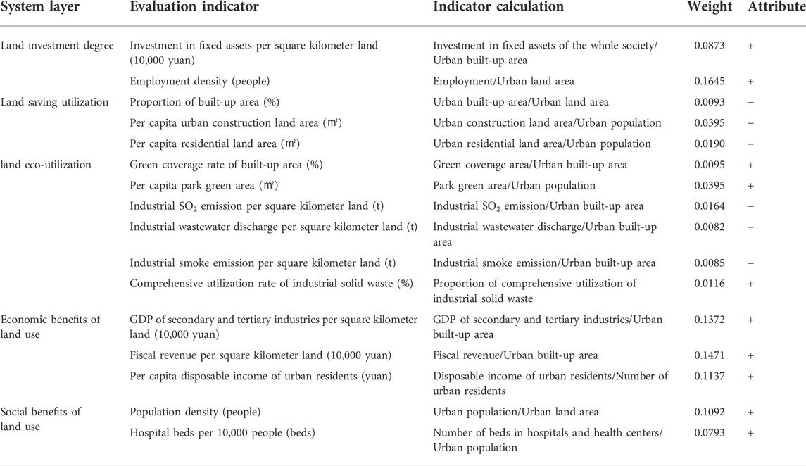
TABLE 1. Evaluation index system of ULIU.
3.2 Exploratory spatial analysis
Exploratory spatial data analysis (ESDA) is an analytical method for measuring the spatial correlation of attribute data, which usually includes global spatial autocorrelation and local spatial autocorrelation.
3.2.1 Global spatial autocorrelation
Global spatial autocorrelation is mainly used to analyze the association and clustering characteristics of attribute data in the whole region. In this paper, Global Moran’s I index is used to measure the global spatial correlation characteristics of ULIU level in the Yangtze River Delta. The calculation formula is as follows:
where
3.2 2 Local spatial autocorrelation
Local spatial autocorrelation is mainly used to measure the local spatial association characteristics of attribute data to analyze the local spatial imbalance, so as to discover the spatial heterogeneity characteristics of attribute data. In this paper, Local Moran’s I index is used to measure the local spatial correlation characteristics and heterogeneity of ULIU level in the Yangtze River Delta. The calculation formula is as follows:
3.2.3 Spatial weight matrix
Commonly used spatial weight matrices include adjacency weight matrix, distance weight matrix, economic weight matrix and nested weight matrix. According to the Tobler’s first law of geography, the interaction between regions decays with increasing distance. Due to the high degree of regional integration in the Yangtze River Delta, there are frequent factor flows and interactions even between cities that are not spatially adjacent to each other. By referring to the existing literature (Li et al., 2021), this paper chooses the spatial weight matrix of threshold distance to examine the spatial correlation characteristics of ULIU level in the Yangtze River Delta. The calculation formula is as follows:
When the distance between city
3.3 Spatial panel econometric model
The spatial panel econometric model can identify spatial interactions between geospatial units by incorporating the spatial effects into a normal panel regression model, and the estimation results are more accurate when the spatial dependence is measured (Yang and Lu, 2021). The frequently used spatial panel econometric models include the spatial panel Lag model (SPLM), the spatial panel Error model (SPEM) and the spatial panel Durbin model (SPDM). The calculation formula of the SPDM model is as follows:
In the formula, the subscripts
4 Spatio-temporal differentiation characteristics of urban land intensive use in the Yangtze River Delta
4.1 General characteristics of urban land intensive use level
Based on the panel data of 41 cities in the Yangtze River Delta, a comprehensive evaluation model was applied to measure the land intensive use level for each city from 2010 to 2020, and the standard deviation and variation coefficient were obtained (Table 2). From 2010 to 2020, the mean value of land intensive use level in the Yangtze River Delta was increased by about 54.14% from 0.165 to 0.278, generally changing from a lower intensive use level to a higher intensive use level. The lowest, highest and median value of land intensive use level increased from 0.165 to 0.278, from 0.472 to 0.760, and from 0.257 to 0.389, respectively, indicating that the land intensive use level of all cities in the Yangtze River Delta had been improved to different degrees with the further optimization of economic and industrial structures at the post-urbanization stage, but the majority of cities still had relatively low land intensive use levels. From 2010 to 2020, the standard deviation increased from 0.064 to 0.090, indicating that the absolute difference in land intensive use level among cities in the Yangtze River Delta was continuously expanded, which means a Matthew effect. The variation coefficient decreased from 0.2411 to 0.2185 with fluctuations, indicating that the relative difference in land intensive use between cities fluctuated during the study period with a generally decreasing tendency, which suggests that the cities with lower intensive use levels achieved significant advancement. This advancement may be ascribed to the spillover of industrial functions from the core cities in the Yangtze River Delta, which improves the land intensive use level of the cities themselves and at the same time promotes the rapid improvement of land intensive use in cities that take over the industries, thereby reducing the relative difference between cities.
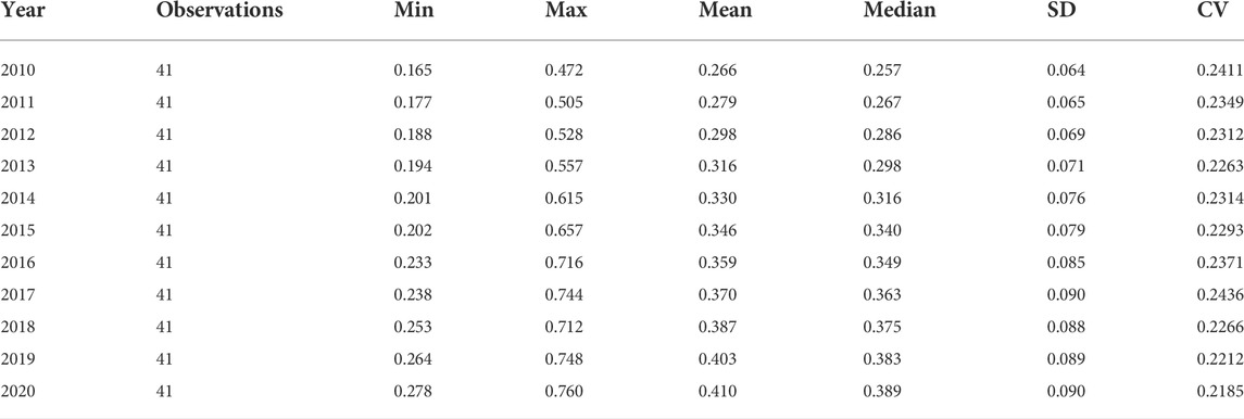
TABLE 2. Descriptive statistics and variation coefficients of ULIU in the Yangtze River Delta from 2010 to 2020.
4.2 Spatio-temporal pattern characteristics of urban land intensive use level
4.2.1 Temporal evolution of urban land intensive use level
As can be seen from Figure 1, from 2010 to 2020, the number of cities with extensive urban land use (
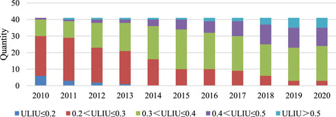
FIGURE 1. Temporal evolution characteristics of ULIU level in Yangtze River Delta from 2010 to 2020.
Furthermore, the ULIU levels in the Yangtze River Delta in 2010, 2015, and 2020 were selected for kernel density estimation to reflect the spatial evolution trend of relative development among cities (Figure 2). 1) In terms of location, the nuclear density curve shifted to the right in turn with narrowing intervals, indicating continuous improvement of ULIU level in the Yangtze River Delta during the study period, but the increase gradually slowed down over time. 2) In terms of shape, the nuclear density curve shows a “single peak” shape, and the wave peak exhibits a downward trend, indicating certain polarization in the ULIU level, but this polarization phenomenon is gradually alleviated. During the study period, the distribution range of the curve was significantly expanded, indicating that the absolute difference in land intensive use level among cities in the Yangtze River Delta was gradually expanded. 3) In term of the curve tail, the tail on the left side is continuously shortened, while that on the right side shows a trend of lengthening and thickening, indicating that there were continuous decreases in the proportion of cities with low values and increases in the number of cities with high values in terms of ULIU level.
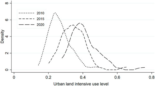
FIGURE 2. Kernel density estimation of ULIU level in Yangtze River Delta from 2010 to 2020.
4.2.2 Spatial differentiation of urban land intensive use level
With the geographic statistical analysis tool of arcgis 10.6 software, spatial interpolation was used to analyze the trend of discrete ULIU data, so as to reveal its spatial differentiation and development trend. As shown in Figure 3, there are generally obvious spatial differences in ULIU level (
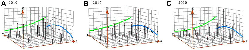
FIGURE 3. Trend surface analysis of ULIU level in Yangtze River Delta from 2010 to 2020.
Further, according to the above classification of land intensive use level, the spatial distribution of ULIU level in 2010, 2015, and 2020 was visualized (Figure 4), which can more clearly reveal the spatial differentiation characteristics of ULIU level in the Yangtze River Delta. As a whole, from 2010 to 2020, there was an obvious “circle” pattern of land intensive use level in the Yangtze River Delta. Cities along the Yangtze River and coastal cities around Hangzhou Bay showed significant improvement in land intensive use level, resulting in the formation of high-value agglomeration areas, while the mountainous and hilly cities in Zhejiang and southwestern Anhui had relatively low land intensive use levels. Specifically, the ULIU level in the Yangtze River Delta was generally low in 2010. The core cities with Shanghai as the center had significantly higher land intensive use levels than the peripheral cities, and the level follows an order of Shanghai > Jiangsu > Zhejiang > Anhui. In 2015, the ULIU in the Yangtze River Delta was dominated by medium levels. Among all cities, the land intensive use level increased rapidly in the provincial capital cities, and decreased gradually from coastal areas to inland. Shanghai was of a high level of ULIU; the core cities such as Hangzhou, Nanjing, Suzhou, Wuxi and Changzhou were of relatively high levels; while Lianyungang, Lishui and most cities in Anhui Province were still at low levels of land intensive use. In 2020, cities along the Yangtze River showed significant improvement in land intensive use level, with high-value regions gradually gathering along the Yangtze River and around the Hangzhou Bay. Shanghai, Hangzhou, Ningbo, Suzhou, Wuxi, Changzhou and other cities had high levels of intensive land use. The central and southern regions of Jiangsu, the central region of Anhui and the northern region of Zhejiang were at relatively high levels of land intensive use, while Lianyungang, Anqing and Huangshan were still at low levels. The spatio-temporal differentiation of ULIU level in the Yangtze River Delta region demonstrates that the provincial capital cities, economically developed cities and cities with good transportation location have more intensive and efficient land use. Moreover, they have a radiating and driving effect on the surrounding cities to contribute to the formation of high-value agglomeration areas. However, cities in southwestern Zhejiang and southern Anhui, which are located in mountainous and hilly areas, have relatively low land intensive use levels due to the constraints of terrain, landform and transportation location.
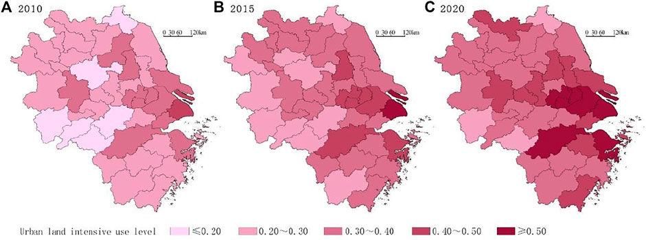
FIGURE 4. Spatial pattern characteristics of ULIU level in Yangtze River Delta from 2010 to 2020.
4.3 Spatial correlation analysis of urban land intensive use level
The ULIU level in the Yangtze River Delta shows an agglomeration trend in spatial pattern. The global Moran’s I index of the value of ULIU in the Yangtze River Delta from 2010 to 2020 was further calculated with the Stata 16 software (Table 3). The results show that the Moran’s I value of each year is greater than 0 and passes the significance level test of 1%, indicating a significant spatial positive correlation between ULIU level in the Yangtze River Delta. From 2010 to 2020, the value of Moran’s I index increased from 0.317 to 0.391, exhibiting a generally fluctuating upward trend, which indicates continuous enhancement of the spatial agglomeration of ULIU in the Yangtze River Delta.
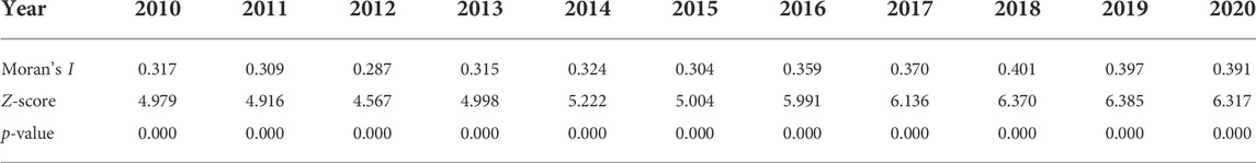
TABLE 3. Global Moran’s I index of ULIU in the Yangtze River Delta from 2010 to 2020.
Since the global Moran’s I index cannot reflect the spatial agglomeration characteristics of local areas, this paper uses the local Moran’s I index and Moran scatter map to draw the Lisa agglomeration map of ULIU level in the Yangtze River Delta in 2010, 2015, and 2020, with the aim to determine whether there is local spatial differentiation in ULIU. As shown in Figure 5, there are four types of local spatial characteristics of ULIU in the Yangtze River Delta, and the number of cities of each type is reported in parentheses. 1) The first type is “high-high” agglomeration (H-H). The land intensive use level of these cities and their neighboring cities is high with small spatial differences, exhibiting a typical high-level agglomeration. During the study period, the H-H agglomeration cities are mainly distributed in the eastern coastal area, and show a spatio-temporal evolution trend of gradually spreading to the periphery with Shanghai as the core with time. 2) The second type is the “low-low” agglomeration (L-L), with low land intensive use levels in both these cities and adjacent cities. During the study period, L-L agglomeration cities are mainly distributed in southwest Anhui, and show an increasing trend over time, indicating that the land intensive use of hilly cities in the southwest of the Yangtze River Delta shows a low-level agglomeration and spreading trend. 3) The third type is the “low-high” agglomeration (L-H). These cities have low land intensive use levels while the neighboring cities have high land intensive use levels, including Nanjing, Huzhou, Shaoxing and other cities in the core circle of the Yangtze River Delta. The number of cities with L-H agglomeration decreases with time. 4) The fourth type is the “high-low” agglomeration (H-L), in which cities with high land intensive use levels are agglomerated with neighboring cities of low levels, including Hefei and other cities. The H-L agglomeration pattern is stable in both space and quantity. As a whole, the number of H-H and L-L agglomeration cities accounts for a large proportion with continuous increases, indicating that the land intensive use level of adjacent cities in the Yangtze River Delta has similar characteristics in space, and the “high-level polar core” agglomeration in the eastern coastal region and the spreading pattern of “low-level trap” in the mountainous and hilly regions in southwest Anhui are generally stable in space. The main reason may be that the Yangtze River Delta has a high level of urban regional integration with frequent flow of factors between cities, and there are mutual learning and influencing effects in economic/industrial development model and land development/utilization policies, resulting in the convergence of land intensive use level.

FIGURE 5. LISA agglomeration map of ULIU level in the Yangtze River Delta from 2010 to 2020.
5 Spatial effects and influencing factors of urban land intensive use in the Yangtze River Delta
5.1 Variable selection and multicollinearity test
The ULIU level is affected by many factors. Based on the existing research, the actual situation of cities, and the availability of data, this paper analyzes the influencing factors of ULIU in the Yangtze River Delta from six aspects: economic development, population urbanization, industrial structure, infrastructure, scientific and technological innovation and government financial pressure. The level of economic development is the most important factor that influences the level of land intensive use by affecting the flow of capital and population factors. Population urbanization affects the level of land intensive use by promoting population agglomeration in cities and promoting the expansion of construction land. Compared with the primary and secondary industries, the tertiary industry has a higher utilization efficiency of construction land, and therefore the industrial structure is an important factor affecting the intensive use of urban land. Infrastructure can drive the expansion of construction land and support high-intensity land development, thereby affecting the level of land intensive use. Scientific and technological innovation affects land intensive use by improving production technology. Government intervention plays an important role in the process of urban land development, and financial pressure affects land intensive use through land transfer. To sum up, this paper correspondingly selects six explanatory variables (Table 4), including GDP per hectare (
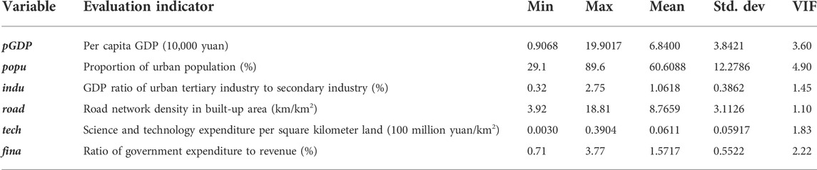
TABLE 4. Descriptive statistics and multicollinearity test of explanatory variables.
5.2 Verification and selection of spatial panel econometric model
The results of spatial autocorrelation analysis show that there are spatial correlations in the ULIU level in the Yangtze River Delta, which rejects the basic assumption based on the mutual independence of samples in traditional research. Therefore, it is necessary to introduce the spatial econometric model to analyze the internal mechanism of the spatial effect. Firstly, the LM test is used to select the spatial metrology model. As shown in Table 5, the LM lag and LM error both pass the significance level test of 1%, while the robust LM lag and robust LM error both pass the significance level test of 5%, indicating the simultaneous existence of spatial Lag model and spatial Error model. Hence, the spatial Durbin model is the priority. Secondly, in order to verify whether the spatial Durbin model will be degenerated into spatial Lag model or spatial Error model, the LR test and Wald test are further carried out. As a result, both the LR test and Wald test reject the original assumption that the spatial Durbin model can be simplified into spatial Lag model or spatial Error model at the 1% significance level. Moreover, the Hausman test results pass the 5% significance test, indicating that the original hypothesis of random effect should be rejected and the fixed effect should be accepted. Therefore, the spatial panel Durbin model with the fixed effect is finally selected in this paper.

TABLE 5. Spatial panel econometric model test results.
Table 6 presents the estimation results of the spatial panel Durbin model under the random effect and the fixed effect, respectively. The spatial regression coefficients of the explained variables are positive under the estimation of random effect or fixed effect, both of which pass the significance level test of 1% with relatively robust outcomes, further verifying a significant positive spatial spillover effect in ULIU in the Yangtze River Delta. In other words, the local ULIU level plays a positive role in promoting the land intensive use in neighboring cities.
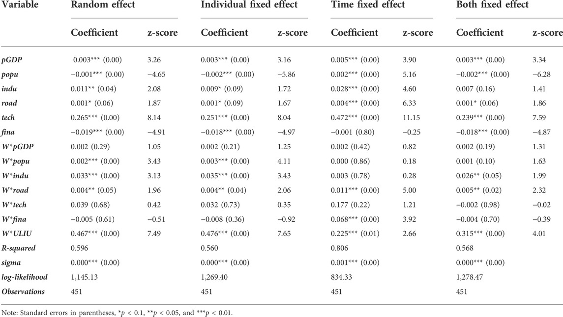
TABLE 6. Spatial panel durbin model regression results.
5.3 Influencing factors and spatial effects of land intensive use level
Among the estimates of three fixed effects, the goodness of fit (
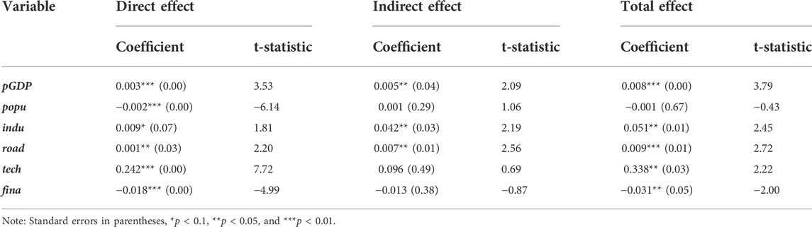
TABLE 7. Decomposition results of the spatial effects of spatial panel Durbin model.
1) The direct, indirect and total effect coefficients of economic development is 0.003, 0.005, and 0.008, respectively, all of which pass the significance level test of 5%, indicating that economic development has a significant positive impact on regional land intensive use. Improvement of economic development can not only promote the land intensive use level in local cities, but also have a positive spatial spillover effect on the land intensive use in neighboring cities. This is mainly because cities with higher economic development generally have better industrial structure and industrial development model and can attract more capital and labor, which can significantly promote their land intensive use. In addition, the economic development models among provinces and cities in the Yangtze River Delta all have their own unique characteristics, forming the nationally famous “Southern Jiangsu model” and “Wenzhou model.” The “mutual competition” relationship between cities is stronger than the “siphon” relationship, which means that the economic development of local cities is not at the expense of the economic development of neighboring cities. Instead, the relationships between cities are more cooperative, complementary and jointly promoted. Therefore, the improvement of economic development plays a significant role in promoting the land intensive use level of both the local cities and neighboring cities.
2) The direct effect coefficient of population urbanization is −0.002, passing the significance level test of 1%. The indirect effect coefficient and total effect coefficient of population urbanization are 0.001 and −0.001, respectively, both of which fail to pass the significance level test of 10%. These results indicate that population urbanization has an insignificant effect on regional land intensive use, but has a negative effect on local ULIU. This also indirectly reveals the practical problems of the current urbanization in the Yangtze River Delta, which focuses on the quantity while ignores the quality of population urbanization. For a long time, many cities are still following the traditional mode of promoting the expansion of urban construction land through population urbanization. The increase in urban population brings about increasing demand for residence, employment and public services, and promotes the continuous expansion of urban construction land. However, the driving effect of population urbanization on economy and society largely lags behind, resulting in a decrease in ULIU level to a certain extent.
3) The coefficients of direct effect, indirect effect and total effect of industrial structure level are 0.009, 0.042 and 0.051, respectively, all of which pass the 10% significance level test, indicating that industrial structure plays a significant positive role in promoting regional land intensive use. Compared with the secondary industry, the tertiary industry requires less construction land, resources and energy and has higher economic and social benefits and less environmental pollution. Therefore, an increase in the proportion of the tertiary industry can significantly promote intensive and efficient use of urban land. In recent years, the core cities in the Yangtze River Delta have gradually switched to a high-quality development path, with the continuous outflow of industrial functions. There has been an obvious trend of “shifting from the secondary industry to the tertiary industry,” which has greatly promoted the economic output and population agglomeration of urban construction land. This trend not only promotes the ULIU level, but also has a positive impact on the industrial layout of neighboring cities that take over the spillover industries, thus improving the land intensive use level in neighboring cities. In addition, with the further promotion of regional integration in the Yangtze River Delta, the industrial correlation between cities is becoming increasingly closer, and the regional industrial system and industrial structure are gradually optimized, which further promotes the land intensive use level. Therefore, the upgrading of industrial structure also plays a significant role in promoting land intensive use in both local cities and neighboring cities.
4) The coefficients of direct effect, indirect effect and total effect of infrastructure are 0.001, 0.007, and 0.009, respectively, all of which pass the significance level test of 5%. Therefore, infrastructure has a significant positive impact on regional land intensive use, whose improvement not only promotes the land intensive use level in local cities, but also promotes that in neighboring cities through the spatial spillover effect. Infrastructure is an important factor and driving force to support the land intensive use. For example, the increase in road network density can provide a driving force for more efficient use of urban land, and support more intensive economic and social activities in urban areas. Secondly, all kinds of production factors in the Yangtze River Delta migrate through the traffic network as an intermediary, and the traffic infrastructure construction between cities can promote each other with regional integration. Through road transportation, the “urban integration” between cities will be enhanced, which will also improve the land intensive use level of adjacent cities. For example, Shanghai has high degrees of integration on transportation network with Suzhou, Wuxi, Changzhou and other cities, and the flow and exchange of elements between cities are also more frequent. Therefore, these cities have relatively higher land intensive use levels.
5) The coefficients of direct and total effect of scientific and technological innovation are 0.242 and 0.338, respectively, both passing the significance level test of 5%, and the indirect effect coefficient is 0.096, which fails to pass the significance level test of 10%. Hence, the improvement of scientific and technological innovation can promote the ULIU level as well. Previous studies have demonstrated that increasing investment in scientific and technological innovation can effectively improve production efficiency, reduce energy consumption and pollution emissions of enterprises through new technologies, thereby improving the economic and ecological benefits of the land (Luo et al., 2022). The progress of science and technology in certain cities can spill over to neighboring cities, and promote the improvement of scientific and technological innovation of the neighboring cities, thus improving land intensive use level, but this spillover effect is not significant.
6) The coefficients of direct and total effect of government financial pressure are −0.018 and −0.031, respectively, both passing the significance level test of 5%, and the coefficient indirect effect is −0.013, which does not pass the significance level test of 10%. These results indicate that local financial pressure has a negative impact on ULIU, which also suggests that the economic development in most cities still heavily relies on “land finance.” Local governments tend to relieve financial pressure by transferring a large amount of land and obtaining land transferring fees, which leads to the disorderly expansion of urban construction land and decline of ULIU. This is consistent with the findings of Zhang et al. (2021). However, the spatial spillover effect of government financial pressure on land intensive use is not obvious.
6 Conclusion and implications
6.1 Conclusion
In the context of comprehensive land space management, it is extremely important to control the spread of urban construction land, promote the efficient and intensive use of stock land and realize high-quality development of urban land resources. Based on the connotation of high-quality land intensive use, this paper constructs a comprehensive evaluation index system to measure land intensive use from five dimensions, including land input intensity, land economical use, land ecological use, land economic and social benefits, and analyzes the spatio-temporal evolution characteristics and spatial correlation of ULIU level in the Yangtze River Delta. Moreover, the spatial effect of influencing factors is analyzed by the spatial panel Durbin model and partial differential method. The following conclusions can be drawn.
1) In terms of time, from 2010 to 2020, the average value of ULIU level in the Yangtze River Delta increased from 0.266 to 0.410, showing a generally continuous upward trend, and the absolute difference in land intensive use level among cities was continuously expanded, while the relative difference fluctuated with an overall downward trend and the polarization trend tended to be reduced. In terms of space, the ULIU level in the Yangtze River Delta is significantly different among cities. The land intensive use level in cities along the Yangtze River and coastal cities around Hangzhou Bay has been significantly improved, with the formation of high-value agglomeration areas, while the mountainous and hilly cities in Zhejiang and southwestern Anhui have relatively low land intensive use levels.
2) During the study period, there are significant positive spatial correlations in ULIU in the Yangtze River Delta, and the spatial agglomeration effect is continuously strengthened. With the function spillover and industrial transfer of core cities in the Yangtze River Delta, the intensive land use level in surrounding cities has been significantly improved and the spatial agglomeration degree has been continuously enhanced. In terms of local characteristics, there are four types of local spatial characteristics for ULIU in the Yangtze River Delta, which are dominated by H-H agglomeration and L-L agglomeration. The land intensive use level of adjacent cities in the Yangtze River Delta has similar characteristics in space, and the “high-level polar core” accumulation in the eastern coastal region and the “low-level trap” spreading pattern in the mountainous and hilly region in southwestern Anhui are somewhat stable in space.
3) In view of the estimation results of spatial panel Durbin model, the spatial regression coefficient of ULIU level of the explained variable is significantly positive, indicating that there are significant positive spatial spillover effects in the Yangtze River Delta, suggesting that the land intensive use levels between adjacent cities are not independent of each other, but are mutually dependent through spatial transmission. Therefore, it is necessary to include the spatial effect into the study of ULIU to better reveal its internal mechanism.
4) According to the spatial effect decomposition results of the spatial panel Durbin model, economic development, industrial structure and infrastructure can significantly promote the land intensive use level of both the local cities and adjacent cities. Scientific and technological innovation plays a significant role in promoting land intensive use in local cities, but has no obvious positive spillover effect on land intensive use in adjacent cities. Population urbanization and local government financial pressure have significant negative effects on local ULIU, but have no significant spillover effect on the ULIU of adjacent cities.
6.2 Policy inspiration
At present, most cities in the Yangtze River Delta still have rather low land intensive use levels with large spatial differentiation, indicating that the inefficient spread of construction land is still serious. With the integrated development of three provinces and one municipality in the Yangtze River Delta, contradiction between the supply and demand of land resources, excessive consumption of energy resources, pressure on ecological environment protection and other issues will become increasingly prominent, posing great challenges to the strategic goal of building an ecological and green integrated development demonstration area in the Yangtze River Delta urban agglomeration. Under the guidance of high-quality development, this study contributes certain reference for better understanding the urban land development in the Yangtze River Delta, optimization of land spatial development pattern and formulation of relevant land policies. Based on our research results, the following three policy recommendations can be proposed. 1) The spatial spillover effect of intensive land use should be fully recognized. By breaking the administrative restrictions, the local government is supposed to encourage cooperation and exchange between cities in land resource and economic and industrial development so as to build consensus and promote the high-quality utilization of regional national resources. 2) A “scientific and technological innovation community”3 in the Yangtze River Delta is to be built by making full use of the strategic opportunities, so as to transform the economic development mode, promote industrial upgrading, vigorously develop high-end and high-tech industries, improve land economic and social benefits and relieve local financial pressure. Besides, the “land finance” dependence mode should be changed to local economic development, so as to achieve the high-quality and intensive use of land resources. 3) It is necessary to strengthen the development path of new urbanization, shifting the focus from the quantity of urban population to the quality of urban population. Moreover, the local government should increase investment in infrastructure and scientific and technological research and improve economic and social benefits of the land. 4) The allocation of land resources is needed to be optimized. A mechanism that links incremental land use to existing land use should be established, which can associate incremental land indicators to the performance of existing land use, encourage the local governments to revitalize the inefficient existing land use, and promote the gradual transformation of land use from scale expansion to quality improvement.
This paper introduces the spatial effect into the study of land intensive use in the Yangtze River Delta, which has an important reference value for the rational use and high-quality development of urban land resources in the Yangtze River Delta. However, the high-quality development of land intensive use is a new concept, and its evaluation index system and measurement method need to be further refined with the enrichment of theoretical connotations for high-quality development. More importantly, the influencing factors of land intensive use are very complex. Due to the restriction of data availability, this paper only selects the most representative factors such as economic development, population urbanization, industrial structure, infrastructure, scientific and technological innovation and local financial pressure for research. There are still other factors to be further discussed. Finally, although the Yangtze River Delta is typical to some extent, it cannot represent other urban agglomerations. Therefore, the land intensive use of other urban agglomerations can be compared in the follow-up study, so as to explore the spatio-temporal characteristics and differentiation mechanism between different urban agglomerations.
Data availability statement
The original contributions presented in the study are included in the article/supplementary material, further inquiries can be directed to the corresponding authors.
Author contributions
Project administration, funding and review, XL; Conceptualization, methodology, formal analysis, writing-original draft preparation and visualization, CC; Data curation and software, YP; Validation, JQ; Writing-editing, TY. All authors have read and agreed to the published version of the manuscript.
Funding
This research was funded by the National Natural Science Foundation of China (71974071 and 42171286).
Conflict of interest
The authors declare that the research was conducted in the absence of any commercial or financial relationships that could be construed as a potential conflict of interest.
Publisher’s note
All claims expressed in this article are solely those of the authors and do not necessarily represent those of their affiliated organizations, or those of the publisher, the editors and the reviewers. Any product that may be evaluated in this article, or claim that may be made by its manufacturer, is not guaranteed or endorsed by the publisher.
Footnotes
1Data from Statistical Communiqué of the People’s Republic of China on the 2021 National Economic and Social Development issued by National Bureau of Statistics of China.
2In April, 2020, the Yangtze River Delta Regional Transportation Development Plan for Higher Quality Integration, which was issued by the National Development and Reform Commission of the People’s Republic of China, proposed to uniformly plan and build the transportation infrastructure in the metropolitan area so as to strengthen the connection between the central city and other cities on intercity and suburban railways, roads and bus lines in neighboring areas, and to accelerate the construction of Shanghai metropolitan area and 1-h commuter network covering Nanjing, Hangzhou, Hefei, Suzhou-Wuxi-Changzhou, and Ningbo.
3In December 2020, the Ministry of science and technology of the People’s Republic of China issued the construction and development plan for scientific and technological innovation community in the Yangtze River Delta, which proposed that the Yangtze River Delta region would be fully built into a world leading scientific and technological innovation community by 2035.
References
Cen, X., Wu, C., Xing, X., Fang, M., Garang, Z., and Wu, Y. (2015). Coupling intensive land use and landscape ecological security for urban sustainability: an integrated socioeconomic data and spatial metrics analysis in hangzhou city. Sustainability 7 (2), 1459–1482. doi:10.3390/su7021459
EddieHui, -C. M., Wu, Y., Deng, L., and Zheng, B. (2015). Analysis on coupling relationship of urban scale and intensive use of land in China. Cities 42, 63–69. doi:10.1016/j.cities.2014.09.002
Fan, J., Zhou, L., and Yu, X. (2018). Industrial structure evolution, urbanization quality and intensive land use: Spatial-temporal evolution and their relationship. Areal Res. Dev. 37 (4), 19–24. doi:10.3969/j.issn.1003-2363.2018.04.004
Fang, C., and Ma, H. (2013). New city district development and intensive land use in the context of new-type urbanization. China Land Sci. 27 (7), 4–9. doi:10.13708/j.cnki.cn11-2640.2013.07.004
Gong, S. (2013). Study on the coupled coordination degrees between urban land intensive use system and social economic development - a case of shandong province. Adv. Mat. Res. 1-6 726-731, 4827–4830. doi:10.4028/www.scientific.net/amr.726-731.4827
Li, M., Zheng, Z., and Chen, S. (2021). Development level of county digital inclusive finance: Spatial pattern evolution and influencing factors analysis: take hunan province as an example. Econ. Geogr. 41 (8), 136–143. doi:10.15957/j.cnki.jjdl.2021.08.016
Li, S., Guo, X. X., Yang, Y., Liu, Y., and Xu, T. R. (2016). Biological function of the small G protein rap. Sheng Li Ke Xue Jin Zhan 6, 14–20. doi:10.13239/j.bjsshkxy.cswt.160602
Li, X., Jiang, B., and Chu, N. (2017). Analysis of coupled coordination of intensive land use and new urbanization in three major coastal cities of China. Resour. Environ. Yangtze Basin 26 (7), 983–991. doi:10.11870/cjlyzyyhj201707004
Li, X., Jiang, D., and Qu, F., (2009). Metrical relationship between the marginal land use and economic growth. China Popul. Resour. Environ. 19 (3), 92. doi:10.3969/j.issn.1002-2104.2009.03.019
Liang, Y., Liu, C., and Cai, X. (2019). Coordination analysis of urban land price and land intensive use: a case study of heibei province. Geogr. Geo-Information Sci. 35 (3), 85–93. doi:10.3969/j.issn.1672-0504.2019.03.013
Liang, Z., Chen, W., and Zheng, J. (2018). Influence of land intensive use level on main atmospheric pollutants in the central urban area of Nanchang City, China. Chin. J. Appl. Ecol. 29 (5), 1705–1714. doi:10.13287/j.1001-9332.201805.031
Lin, J., Zhang, P., and Liu, S. (2009). Discussion on technical system and perspectives of evaluation on construction land saving and intensive use. China Land Sci. 23 (4), 4–10. doi:10.13708/j.cnki.cn11-2640.2009.04.003
Liu, J., Hou, X., Wang, Z., and Shen, Y. (2021). Study the effect of industrial structure optimization on urban land-use efficiency in China. Land Use Policy 105, 105390. doi:10.1016/j.landusepol.2021.105390
Liu, X., Zhang, L., and Li, M. (2006). Research on intensive utilization of land resources in China. Beijing: Geological Publishing House.
Luo, X., Lu, X., Zhang, Z., and Pan, Y. (2020). Regional differences and rural public expenditure cyclicality: evidence from transitory and persistent shocks in China. Ann. Reg. Sci. 65, 281–318. doi:10.1007/s00168-020-00985-5
Luo, X., Qin, J., Wan, Q., and Jin, G. (2021). Expenditure fluctuation and consumption loss: rural spatial poverty in China. Technol. Econ. Dev. Econ. 27 (6), 1357–1382. doi:10.3846/tede.2021.15374
Luo, X., Cheng, C., Pan, Y., and Yang, T. (2022). Coupling coordination and influencing factors of land development intensity and urban resilience of the yangtze River delta urban agglomeration. Water 14 (7), 1083. doi:10.3390/w14071083
Pan, Y., Cheng, C., and Hong, L. (2017). Research on the spatial control zoning in urban(county) based on multiple plans coordination. Urban Dev. Stud. 24 (3), 1–8.
Peng, C., Song, M., and Han, F. (2017). Urban economic structure, technological externalities, and intensive land use in China. J. Clean. Prod. 152, 47–62. doi:10.1016/j.jclepro.2017.03.020
Peng, C., Xiao, H., and Han, F. (2014). Analysis on the characters of spatial agglomeration evolvement and disparity of the intensive urban land use in China from 2003 to 2012. China Land Sci. 28 (12), 24–31. doi:10.13708/j.cnki.cn11-2640.2014.12.004
Pratama, A. P., Yudhistira, M. H., and Koomen, E. (2022). Highway expansion and urban sprawl in the jakarta metropolitan area. Land Use Policy 112, 105856. doi:10.1016/j.landusepol.2021.105856
Song, D., Miao, C., and Yang, R. (2015). Intensive land use indicators evaluation: A case of wuhan. China Popul. Resour. Environ. 25 (S1), 62–65.
Sun, P., Lv, F., and Xiu, C. (2015). Basic cognition and evaluation of urban economical and intensive land use under the new urbanization. Econ. Geogr. 35 (8), 178–183. doi:10.15957/j.cnki.jjdl.2015.08.025
Tan, Y., Xu, W., and Han, X. (2018). Evaluation of economical and intensive utilization of construction land in the new era: a case study of changsha meixihu area. Econ. Geogr. 38 (9), 200–205. doi:10.15957/j.cnki.jjdl.2018.09.023
Wang, Q., Wang, W., and Jin, W. (2017). New perspectives and new methods on the research of intensive urban land use in China: literature review and prospect. China Popul. Resour. Environ. 27 (S1), 95–100.
Wang, T. (2020). A study on the relationship between intensive land use and carbon emissions: A case study of beijing-tianjin-hebei urban agglomeration. Beijing, China: China University of Geosciences Peking. doi:10.27493/d.cnki.gzdzy.2020.001392
Wang, X., Liu, X., and Pei, T. (2019). Potential evaluation of urban land intensive use in Beijing-Tianjin-Hebei region based on measurement of technical efficiency. Acta Geogr. Sin. 74 (9), 1853–1865. doi:10.11821/dlxb201909011
Wang, Z., Fu, L., and Chen, W. (2010). Evaluation and empirical analysis of urban land intensive use in China -- a case study of three major urban agglomerations. Inq. into Econ. Issues 340 (11), 95–99.
Wei, N., Chen, H., and Xu, L. (2017). A comparative study on evaluation methods of land intensive utilization in development zone. Resour. Environ. Yangtze Basin 26 (10), 1556–1563. doi:10.11870/cjlyzyyhj201710008
Wu, S., Chen, W., and Zheng, J. (2020). Study on factors affecting industrial land use intensity of development zones based on Hierarchical Linear Model. China Land Sci. 34 (1), 53–60. doi:10.11994/zgtdkx.20191226.100321
Xie, H., Zhai, Q., Wang, Wei., Yu, J., Lu, F., and Chen, Q. (2018). Does intensive land use promote a reduction in carbon emissions? evidence from the chinese industrial sector. Resour. Conservation Recycl. 137, 167–176. doi:10.1016/j.resconrec.2018.06.009
Xiong, Y., Chen, Y., Peng, F., Li, J., and Yan, X. (2017). Analog simulation of urban construction land supply and demand in Chang-Zhu-Tan Urban agglomeration based on land intensive use. J. Geogr. Sci. 29 (8), 1346–1362. doi:10.1007/s11442-019-1663-5
Xu, W., Xu, Z., and Liu, C. (2021). Coupling analysis of land intensive use efficiency and ecological well-being performance of cities in the Yellow River Basin. J. Nat. Resour. 36 (1), 114. doi:10.31497/zrzyxb.20210108
Yang, F. (2020). The influence of urban land intensive use on economic development. Shenzhen, China: Harbin Institute of Technology. doi:10.27061/d.cnki.ghgdu.2020.000653
Yang, J., Huang, X., and Wang, Z. (2020). Re-understanding of some issues in urban land intensive use of China in the new era. China Land Sci. 34 (11), 31–37. doi:10.11994/zgtdkx.20201103.134814
Yang, J., Yang, Y., and Tang, W. (2012). Development of evaluation model for intensive land use in urban centers. Front. Archit. Res. 1 (4), 405–410. doi:10.1016/j.foar.2012.07.006
Yang, J., Zeng, C., and Cheng, Y. (2020). Spatial influence of ecological networks on land use intensity. Sci. Total Environ. 717, 137151. doi:10.1016/j.scitotenv.2020.137151
Yang, R., Wang, Y., and Xu, Q., (2016). Spatial characteristics of urban land use intensity level and optimization strategies analysis for China. J. Arid Land Resour. Environ. 30 (10), 53–58. doi:10.13448/j.cnki.jalre.2016.316
Yang, X., and Lu, X. (2021). Driving factors of urban land urbanization in China from the perspective of spatial effects. China Popul. Resour. Environ. 31 (1), 156–164. doi:10.12062/cpre.20200422
Ye, H., Zhuang, D., and Yang, L. (2015). Evaluation of urban land intensive use in guangdong province: Based on econometric model. J. Nat. Resour. 30 (10), 1664–1674. doi:10.11849/zrzyxb.2015.10.006
Yin, X., Li, Y., Yuan, T., and Jing, W. (2020). Quantitative measurement of economic development and land use intensity and their correlation characteristics in 109 sampled towns of Jiangsu province. J. Nat. Resour. 35 (3), 614. doi:10.31497/zrzyxb.20200309
Zhang, M., and Weng, A. (2022). Study on the coordination between industrial structure optimization and urban land use intensity in Northeast China. J. Nat. Resour. 37 (3), 734. doi:10.31497/zrzyxb.20220312
Zhang, N., Bai, Z., and Zhang, Z. (2022). Response of spatiotemporal change of intensive land use to land finance. J. China Agric. Univ. 27 (3), 229–239. doi:10.11841/j.issn.1007-4333.2022.03.24
Zhang, P., Yang, D., Qin, M., and Jing, W. (2020). Spatial heterogeneity analysis and driving forces exploring of built-up land development intensity in Chinese prefecture-level cities and implications for future Urban Land intensive use. Land Use Policy 99. doi:10.1016/j.landusepol.2020.104958
Zhang, S., Liu, X., and Du, S. (2021). Spatial-temporal differences and influencing factors of urban land use efficiency in central plains urban agglomeration. Resour. Environ. Yangtze Basin 30 (10), 2417–2429. doi:10.11870/cjlyzyyhj202110010
Zhang, W., Xu, J., Ma, R., et al. (2019). Basic connotation, current situation, and development orientation of high-quality development of Chinese cities: Based on the survey of residents. City Plan. Rev. 43 (11), 13–19. doi:10.11819/cpr20191104a
Zhang, Z., Zhou, M., and Jin, G., (2018). Coordination analysis of new urbanization and intensive land-use under the spatial pattern of “Two Circles Two Belts” in Hubei Province. World Reg. Stud. 27 (2), 65–75. doi:10.3969/j.issn.1004-9479.2018.02.007
Zhao, D., and Hu, Y. (2016). Quantitative study of the interaction between intensive land use and urbanization in three urban agglomerations of china. Geogr. Res. 35 (11), 2105–2115. doi:10.11821/dlyj201611008
Zhao, M., Li, L., Fang, Y., Zhang, L., Dong, W., Li, Z., et al. (2021). Optimization of intensive land use in blocks of Xi’an from the perspective of bicycle travel. Alexandria Eng. J. 60 (1), 241–249. doi:10.1016/j.aej.2020.07.018
Zhao, Z., Zeng, C., and Cheng, Y. (2020). The spillover effect of traffic network on intensive land use: aA case study in beijing-tianjin-hebei urban agglomeration. Econ. Geogr. 40 (7), 174–183. doi:10.15957/j.cnki.jjdl.2020.07.020
Zhou, Y., and Tan, G. (2016). The impacts of productive services agglomeration on the intensity of urban land use from the spatial perspective. China Land Sci. 30 (10), 37–46. doi:10.11994/zgtdkx.20161026.140620
Zhu, G., Wang, C., and Zhou, J. (2020). Industrial development, intensive land use and urban expansion. Resour. Environ. Yangtze Basin 29 (7), 1473–1485. doi:10.11870/cjlyzyyhj202007001
Keywords: high-quality development, urban land intensive use, spatial effect, spatial panel durbin model, the Yangtze River Delta
Citation: Luo X, Qin J, Cheng C, Pan Y and Yang T (2022) Spatial effects and influencing factors of urban land intensive use in the Yangtze River Delta under high-quality development. Front. Environ. Sci. 10:971466. doi: 10.3389/fenvs.2022.971466
Received: 17 June 2022; Accepted: 13 July 2022;
Published: 09 August 2022.
Edited by:
Qingsong He, Huazhong University of Science and Technology, ChinaReviewed by:
Siliang Wang, Hunan University, ChinaRui Qi, China University of Geosciences Wuhan, China
Min Zhou, Huazhong University of Science and Technology, China
Copyright © 2022 Luo, Qin, Cheng, Pan and Yang. This is an open-access article distributed under the terms of the Creative Commons Attribution License (CC BY). The use, distribution or reproduction in other forums is permitted, provided the original author(s) and the copyright owner(s) are credited and that the original publication in this journal is cited, in accordance with accepted academic practice. No use, distribution or reproduction is permitted which does not comply with these terms.
*Correspondence: Chao Cheng, MzYwMTgwMDAzQHFxLmNvbQ==; Yue Pan, cHk5NTM1MTcyMUAxNjMuY29t