 Zhaolin Wang
 Hao Ye
 Luyang Zhang
- 1Research Center for Economy of Upper Reaches of Yangse River, Chongqing Technology and Business University, Chongqing, China
- 2School of Public Administration, Chongqing Technology and Business University, Chongqing, China
- 3School of Geography and Tourism Shaanxi Normal University, Xi’an, Shaanxi, China
Land use transition results from economic and social transformations. Land use in the mountainous Chengdu-Chongqing region is disturbed by multiple natural factors and economic activities, contributing to the difficulty in space governance in this area. Clarifying the transformation process and mechanism of land use transition and proposing solutions for special regions can help achieve the goal of urban-rural integration development at the national level. This study applied the land use transfer matrix (LUTM), exploratory spatial data analysis (ESDA), and spatial centers of gravity (SCG) and spatial econometric models to explore the characteristics and mechanisms of land use transition in mountainous the Chengdu-Chongqing region. Our findings indicated that: 1) the characteristics of structural transition of land use in this region showed similarity in two phases. In both phases, the size of cultivated land decreased, while that of construction land increased. The increase in construction land area occurred primarily due to the transfer of cultivated land to construction land. The areas of woodland and unused land fluctuated, while the areas of grassland and water body decreased slightly. 2) The characteristics of spatial transition of land use in the Chengdu-Chongqing region showed significant spatial aggregation in different phases. In this period, the gravity center of land use types in the region changed frequently with time. The gravity center of cultivated land moved northwest, while those of woodland moved northeast first and then southwest, that of grassland moved northeast constantly, that of water bodies moved southeast first and then northwest and that of unutilized land moved northwest. 3) The land use transition in the Chengdu-Chongqing region was driven by many natural and socio-economic factors. The growth of construction land in this region was significantly impacted by the available resources, economic growth, urbanization rate, population migration, and policies. With the expansion of regional economic differences, economic growth and the evolution of industrial structures played crucial roles in the transition of construction land. The transfers from cultivated land to woodland and grassland were primarily affected by the policies regarding land use and ecological protection. 4) The mechanism of land use transition in the Chengdu-Chongqing region showed significant coupling. The land use transition in the Chengdu-Chongqing region was a transitional process from conflict to coordination guided by national and regional policies. The conflict in this process was mainly the change in land supply and demand caused by regional economic activities. The quantity of land supply in this region depended heavily on the land use policies for living, production, and ecology. The land use transition in this region was a dynamic coupling system resulting from the interdependence and restriction of natural conditions, social economies, and policy systems.
1 Introduction
Globally, the rapid advancements of industrialization and urbanization in developing countries have profoundly impacted land use activities (Kresse and van der Krabben, 2022; Delbecque et al., 2022). Land use/cover change (LUCC) is the most direct manifestation of the impacts of human activities on land surface systems. Since the 1990s, driven by the International Geosphere-Biosphere Program (IGBP), LUCC has become one of the core issues in geography (Seitzinger et al., 2015). Since the 21st century, the major developing countries across the world have been undergoing socio-economic transformations, contributing to impacts on regional land use (Liu et al., 2021). This land use transition has become a hot issue and frontier of LUCC research in recent years (Long and Qu, 2018). The term land use transition was first used by Grainger in his exploration of land use in forest-oriented countries. The term was defined as the spatio-temporal changes in land use patterns corresponding to regional socio-economic transformations (Grainger, 1986; Grainger, 1995; Grainger et al., 2003). Since the proposal of land use transition coincides with the socio-economic transformation of global emerging market countries, the international community has performed studies on land use transitions.
Studies on land use transitions generally involve the connotation and basic theory (Grainger, 1986; Grainger, 1995; Long et al., 2007), the driving mechanisms (Mather et al., 1999; Tian et al., 2020; Czekajlo et al., 2021), and the impacts of land use transitions on regional environments and ecosystems (Nuissl et al., 2009; Ojoyi et al., 2017; Qu and Long, 2018). In the early 21st century, the concept of land use transition was introduced in China (Long et al., 2007). Chinese scholars have achieved great progress in this field of research and assessment in the context of China’s rapid development. Studies on land use transitions in China have mainly focused on the evolution of spatial-temporal characteristics, drivers, the eco-environmental effects of land use transitions, and the relationships between land use transitions and rural transformations (Tian et al., 2020; Xu and Zhang, 2021; Xing et al., 2022; Feng et al., 2022).
Despite significant progress in the study of land use transitions, there remain significant shortcomings: 1) Existing studies generally overlook the original definition of land use transition proposed by Grainger (1986); that is, regional land use transition is the process and product of socio-economic transformation. Few studies have focused on the impacts of regional socio-economic transformations on land use transitions, leading to unconvincing research results. 2) In terms of driving mechanisms, most studies focused on the impacts of urbanization, industrialization, and population migration on land use transitions (Zhou et al., 2020; Tian et al., 2020; Xu and Zhang, 2021) and not on the impacts of policy factors on socio-economic transformation on land use transition. 3) In terms of study areas, few studies have focused on land use transitions in mountainous areas. In practice, due to the impact of topography, land use in mountainous areas is more constrained (Wang et al., 2020b; Xu et al., 2022) and the process of land transition is more complicated compared to that in plain areas. Consequently, studies are urgently needed on the process and mechanism of land use transitions in mountainous areas.
Over the past four decades of reform and opening-up, China has made remarkable progress in industrialization and urbanization and has also undergone profound economic and social transformations. In this process of these transformations, a series of problems have emerged in China’s land use, such as the constant reduction of cultivated land due to urbanization, the idleness of rural construction land and the abandonment of farmland due to the transfer of rural populations, and the degradation of land ecosystems due to rapid industrialization (Liu et al., 2010; Liu et al., 2013; Liu et al., 2021; Guo and Liu, 2021). Issues of land use caused by socio-economic transformation appear to be more acute in the mountainous areas of southwest China (Li et al., 2019; Wang et al., 2020a; Tan et al., 2021; Xu and Zhang, 2021). The Chengdu-Chongqing region is a major regional economic growth pole located in the mountainous areas of southwest China. The region has also experienced rapid urbanization in the past four decades. The process of urbanization occupied much high-quality farmland, which created an issue with farmland marginalization in this region (Wang et al., 2020a; Wang et al., 2020b). With the rapid advancement of urbanization, many farmers have moved to cities, resulting in idle farmhouses and abandoned farmland (Wu et al., 2022). Furthermore, the intensification of human activities, fragile ecologies, and rapid urbanization have aggravated ecological degradation in special areas (Zhang Q et al., 2020; Xiang et al., 2021). The main reason for these problems is that the land use in mountainous areas is more restrictive than that in plain areas and the transition process is longer. Furthermore, due to the impacts of landform, the land use form and the process and mode of urbanization and industrialization in mountainous areas are also quite different from those in plain areas. Mountainous areas are also ecologically fragile and are prohibited from development, which aggravates ecological degradation due to rapid urbanization in these areas.
To curb these problems, the Chinese government has enacted a series of new policies and measures to promote economic development and the sustainable use of land resources in mountainous areas, including the establishment of pilot zones for coordinated and integrated urban-rural reform, policies to balance the occupation and replenishment of cultivated land, policies to link the increase and decrease of urban and rural construction land, and policies for ecological restoration. These measures and policies have effectively alleviated the problems in the Chengdu-Chongqing region and profoundly impacted the socio-economic development in mountainous areas. Nevertheless, the impacts of socio-economic transformation on land use transitions in mountainous areas and the general mechanism of land use transitions in these areas remain unknown. Furthermore, the role of policy factors in this process and how they interact with socio-economic factors to drive the process of land use transitions in mountainous areas remain unclear. Consequently, exploring the characteristics of the land use transition in mountainous economic zones and clarifying the impact mechanisms of socio-economic transformation on land use transition in special areas are of great significance and an urgent demand has emerged for sustainable land use in mountainous areas in southwestern China.
In this context, we used the LUTM to explore the structural characteristics of land use transitions in different stages of development, applied ESDA and SCG to examine the spatial characteristics of land use transitions, and employed spatial econometric models to explore the influencing factors and mechanisms of land use transition in the mountainous Chengdu-Chongqing region of China. The contributions of this work include 1) summarization of the process of land use transitions in mountainous area based on measurements of the main characteristics of land use transitions in the Chengdu-Chongqing area and 2) the determination of the mechanism of land use transitions in mountainous areas by investigating the land use transitions in different phases of socio-economic transformation in the Chengdu-Chongqing area.
This study can be divided into five sections. Section 2 introduces the research area, research data sources, and research methods, including the establishment of the indicator framework. Section 3 uses Chengdu-Chongqing region as an example to quantitatively explore the structural and spatial characteristics of land use transitions and the processes of these transitions in mountainous areas. Section 4 applies a spatial econometric model to further examine the influencing factors and mechanism of land use transition in mountainous areas. Section 5 is the conclusion of the study.
2 Study area, data, and methodology
2.1 Study area
The Chengdu-Chongqing region, located in the mountainous area of southwest China, is an important economic center and growth pole in the upper reaches of the Yangtze River, known as the fourth growth pole of China. This area borders Shaanxi and Gansu provinces in the north, Yunnan and Guizhou provinces in the south, Hunan and Hubei provinces in the east, and Tibet province in the west (Figure 1). It covers 29 districts of Chongqing and 15 cities of Sichuan, with a total area of 206,000 km2. It is a major urban agglomeration, including population and industry, in China. The Chengdu-Chongqing region is dominated by low mountains and hills.
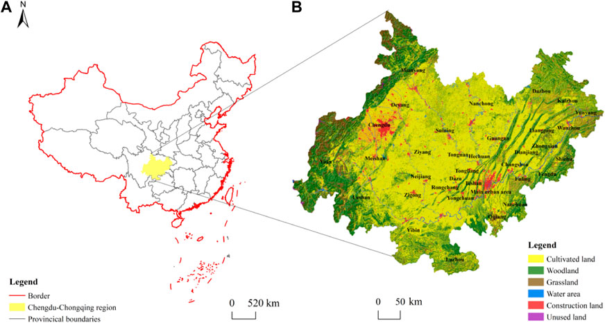
FIGURE 1. (A–B) are respective the maps of China and Chengdu-Chongqing region.
In January 2020, China put forward the strategy for the Chengdu-Chongqing Twin Cities Economic Zone, which has brought new opportunities and challenges for the development of the Chengdu-Chongqing region and will profoundly impact the land use in this region. To better examine the process of land use transition in the Chengdu-Chongqing region, we first discuss the regional socio-economic transformation. This paper divided the socio-economic transformation of the Chengdu-Chongqing region into two phases according to the evolution of the main indicators of regional economic development.
2.1.1 Initial phase of economic transformation (2000–2010)
Regional socio-economic development is closely associated with the support of national policies for regional development (Li et al., 2022). Since Chongqing became a municipality directly under China’s central government, it has grown into an important core to drive the internal economic development of urban agglomeration in the Chengdu-Chongqing region. The implementation of China’s western development strategy has further enhanced the leading position of Chengdu-Chongqing in western China. During 2000–2010, the economy of the Chengdu-Chongqing region developed rapidly, with a GDP growth rate higher than China’s average, although with fluctuations (Figure 2A). While the proportion of secondary industries in the Chengdu-Chongqing region grew steadily, it was lower than China’s average in the same period. The output value and employment of tertiary industries were growing and comparable to China’s average. The secondary industries remained an important engine to drive the economic development of the Chengdu-Chongqing region during this period. The urbanization rate of the Chengdu-Chongqing region rose from 29.8% in 2000 to 39.34% in 2010, which was below the national average (Figure 3). From the perspective of the industrial structure and GDP growth rate, while the economy developed rapidly in this stage, the quality of economic development was lacking.
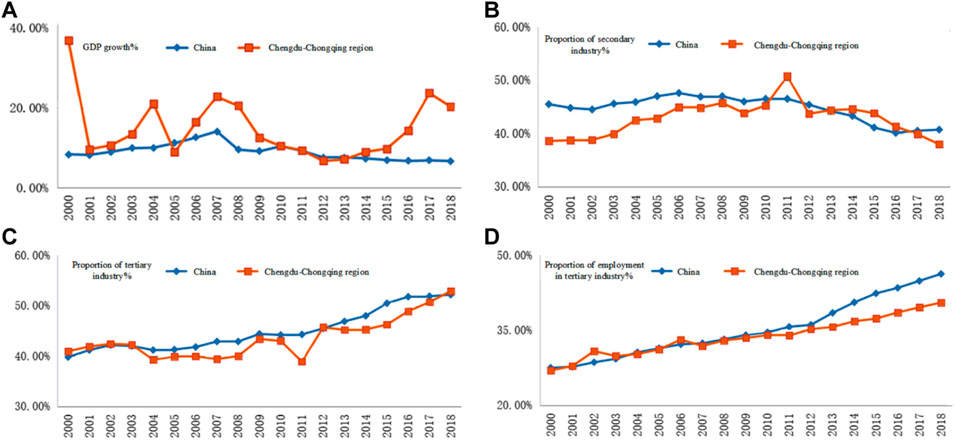
FIGURE 2. Main economic indicators in the Chengdu-Chongqing region, 2000–2018. (A–D) are respective the comparisons between the GDP growth rate, proportion of secondary industry, proportion of tertiary industry, proportion of employment in tertiary industry of Chengdu-Chongqing region and China.
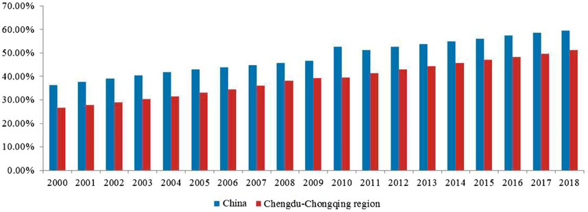
FIGURE 3. Urbanization rate in the Chengdu-Chongqing region, 2000–2018.
2.1.2 Accelerated phase of economic transformation (2010–2018)
In 2007, Chengdu and Chongqing were designated as a national pilot zone for coordinated and integrated urban-rural reform. Since then, the flows of urban-rural factors and the pace of economic transformation in the Chengdu-Chongqing region have been greatly accelerated. During 2010–2018, the GDP growth rate of the Chengdu-Chongqing region also accelerated rapidly. In this period, tertiary industries displaced secondary industries as the leading role and the proportion of employment in the tertiary industry decreased. The natural growth rate of the population in the region was in decline and the population development moved to a lower static stage (Figure 2B). Nevertheless, urbanization accelerated in this region (Figure 3), with increasing rural populations migrating to cities. The development of regional economies drove the urbanization process. Overall, although the GDP growth rate in the Chengdu-Chongqing region slowed in this phase, the industrial structure was constantly optimized and the quality of economic development was constantly improved.
2.2 Framework and variables
In the context of accelerated urbanization and industrialization, the land use patterns changed significantly in the Chengdu-Chongqing region due to the socio-economic transformation. The land use transition in this region is impacted by many factors, which disproportionately reshaped the spatial structure of land use (Figure 4). The changes in land use structure reflected the socio-economic transformation of this region. Specifically, regional land use transition is the process of changing land use due to the transformation and innovation of regional economies and societies in a given period. The land use transition is generally believed to be driven by natural environmental conditions, economic conditions, and human activities (Burra et al., 2021; Swette and Lambin, 2021). The drivers of land use transition also vary according to development stages due to the different productivity levels. In this context, we selected the major types of land use transitions (cultivated land–construction land, cultivated land–woodland, woodland–cultivated land, and waters–cultivated land) as the dependent variables to examine the key factors influencing land use transitions in the Chengdu-Chongqing region.
1) Socio-economic factors. Socio-economic development is the basis for the transformation of regional economies (Esposito et al., 2021; Mahmoud and Vogt, 2021). The Chengdu-Chongqing region is a traditional industrial base in southwest China.
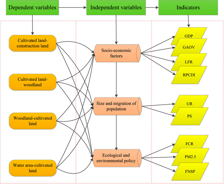
FIGURE 4. Indicator frameworks in the present study.
The Chengdu-Chongqing region is the engine of economic development in western China; with two national central cities, it is also a core growth pole of regional economic development. The economic development of core cities in the Chengdu-Chongqing region can better reflect industrial development and infrastructure layout, and profoundly impact land use transition in the region according to planning. In terms of quantity, the socio-economic transformation can drive the adjustment of the industrial structures in the Chengdu-Chongqing region. The level of regional economic development depends heavily on the degree of different industries’ development. Consequently, the growth of the regional GDP, the improvement of local fiscal revenue (LFR), and the decline of traditional gross agricultural output value (GAOV) are all important indicators of the socio-economic transformation in the Chengdu-Chongqing region. In terms of quality, farmers are the lowest-income group in China; thus, an increase in farmers’ income can reflect the results of socio-economic transformation in the Chengdu-Chongqing region. Therefore, the rural per capita disposable income (RPCDI) of farmers is an important indicator to measure regional socio-economic transformations.
2) Population size and migration. During economic and social development, populations play dual roles of producers and consumers of social material wealth (Stech et al., 2012). Population development and migration affect the level of regional economic development and change the pattern of regional land use. Population is also an important factor impacting the transitions of regional land use (Zhu et al., 2020). The rapid development of urbanization and the constant migration of urban-rural populations in the Chengdu-Chongqing region have greatly affected land use in this region. Land use in cause frequent variation in the Chengdu-Chongqing region is not only affected by planning and management at the regional economic level but is also impacted by population migration, in particular, by economic development. In the context of rapid urbanization, rural populations migrated to the core cities, which also caused a large number of ‘hollow villages’ in rural areas of the Chengdu-Chongqing region. The expansion of cities and the spread of industries to the countryside have led to the occupation of a large amount of farmland. Consequently, the change in population size was positively correlated with land use transition (Petrescu-Mag et al., 2022). The larger the population, the greater the intensity of land use. The changes in regional population cause frequent variations in the spatial structures of regional land use and also reshape the spatial and temporal patterns of land use. Therefore, due to the difficulty in quantifying population diffusion, this study used population size (PS) and urbanization rate (UR) to reflect population size and migration.
3) Ecological and environmental policies. Land can be generally defined as a natural synthesis of geological, geomorphic, climatic, hydrological, vegetation, and other natural elements in a certain section of Earth’s surface (Herrick et al., 2019). Due to the constraints of the natural condition in the region, land use pattern changes constantly and the scarcity of land is highlighted under the influence of natural conditions (Chen et al., 2021). To ensure the sustainability of land use and the ecological environment, governments tend to enact a variety of policies and measures to guide land use activities, alleviating the contradiction between land scarcity and urban sprawl (Zhang Y N et al., 2020). These include policies for farmland protection, spatial planning, ecological restoration, and environmental protection. To some extent, the regional land use transitions caused by these policies are even more influential than those caused by natural, demographic, and economic factors. Therefore, this study considered some variables impacted by eco-environmental policy, including the forest coverage rate (FCR), PM2.5 concentration, and fertilizer non-point source pollution (FNSP).
2.3 Data sources
Existing data on land use in the study area during the three periods (2000, 2010, and 2018) with an accuracy of >94% were obtained in vector format (30 m × 30 m) from the Resources and Environmental Data Center of the Chinese Academy of Sciences (available at http://www.resdc.cn.). DEM data at 30-m cell sizes were obtained from http://www.gscloud.cn/. Land use types are normally classified into cultivated land, garden, woodland, grassland, water area, rural settlement, urban land, and unused land according to the standards of China’s land use classification. ArcGIS was used to estimate the area of each land type in different years and the area transferred between different land types. A spatial analysis tool was used to examine the spatial characteristics of regional land use transitions.
The socio-economic data used in this study were primarily obtained from the China Statistical Yearbook (2001–2019), China Demographic Yearbook (2001–2019), China County/City Social and Economic Statistical Yearbook (2001–2019), Sichuan Statistical Yearbook (2001–2019), and Chongqing Statistical Yearbook (2001–2019).
2.4 Methods
Research on land use transition usually involves quantitative structural and spatial transitions (Long et al., 2014; Long and Qu, 2018). This study first explored the structural characteristics of land use transition by LUTM and then assessed the spatial characteristics, spatial agglomeration characteristics, and transfer rules of land use by ESDA and SCG and summarized the spatial characteristics of land use transition in the study area. Finally, the spatial lag model (SLM) and spatial error model (SEM) were used to analyze the factors influencing the land use transition in the study area.
2.4.1 Land use transfer matrix (LUTM)
LUTM reflects the dynamic changes of transferred areas among different land types in a certain area and a specific period (Table 1). In the matrix,
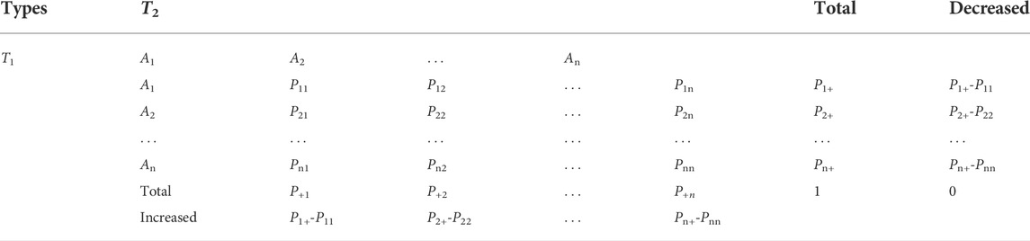
TABLE 1. Land use transfer matrix.
2.4.2 Exploratory spatial data analysis (ESDA)
ESDA is a set of spatial analysis methods used to test whether there exist significant correlations between socio-economic phenomena and their attribute values of the adjacent unit in space (Dou et al., 2016). ESDA can be divided into global spatial and local spatial autocorrelations.
First, we used Moran’s I index of global autocorrelation to examine the spatial correlation of regional land use changes, judged the aggregation, and explored the spatial correlation structure pattern of land use types in the study area. Moran’s I index was used to distinguish whether the distribution state of land spatial features was clustered, discrete, or random. Moran’s I index is generally >−1 or <1. An index value >0 indicates a positive correlation between two geographical phenomena; otherwise, a negative correlation exists between them. The larger the absolute value of Moran’s I index, the stronger the spatial correlation of land use type; that is, there exists a strong spatial aggregation or strong dispersion of land use types. Conversely, the smaller the absolute value, the smaller the correlation of the spatial distribution. An index value approaching 0 indicates a random spatial distribution of land use type at that time point.
Where,
Second, we used the local Getis-ORD
Where
2.4.3 Spatial Centers of Gravity (SCG)
SCG can be used to reflect the spatial agglomeration and transfer rules of factors during regional development (Kuwil et al., 2020). The present study applied SCG to calculate the gravity center changes in the spatial distribution of major land use types in the study area. The model can be structured as follows.
where
2.4.4 Spatial econometric model
Spatial econometric models include a variety of models. This study used the spatial lag model (SLM) and spatial error model (SEM) to examine the relationship between dependent and independent (influencing factors) variables according to the sectional data of the study area in different years. SLM has only a spatial weighting matrix and the explanatory variable contains a spatial lag term of the explained variable, which can be defined as follows.
where Y is the dependent variable; X is the independent variable; W is a spatial weight matrix;
SEM is also known as the spatial autocorrelation model, which includes an added spatial correlation error term; that is, the error term of a space element model is affected by the error term of the adjacent space element model. It can be structured as follows.
where
This study used GeoDa software to perform ordinary least squares (OLS), spatial lag model (SLM), and spatial error model (SEM) analyses, respectively. We selected the models according to the results of comparisons of the Lagrange multipliers of regression analysis and their robust forms (LMlag, LMerror, R-LMlag, and R-Lmerror).
3 Results
3.1 Structural characteristics of the land use transition
During 2000–2018, the size and structure of land use changed significantly in the Chengdu-Chongqing region (Table 2). Specifically, the cultivated land area decreased continuously, the construction land area increased continuously, and the areas of the other land types fluctuated. The total area of cultivated land in this region decreased by 302,100 hm2 due to the transfer of cultivated land to construction land and woodland during this period. The decline rate of cultivated land during 2000–2010 (−1.39%) was higher than that during 2010–2018 (−1.09%). The grassland and water areas decreased by 154,900 hm2 and 11,600 hm2, respectively, in this period. In summary, the areas of woodland, construction land, and unused land increased by totals of 70,400 hm2, 386,900 hm2, and 11,300 hm2, respectively, with the largest increase in construction land.

TABLE 2. Changes in land use types in the Chengdu-Chongqing region, 2000–2018.
We further used LUTM to examine the scale and direction of land use transition in the Chengdu-Chongqing region during 2000–2010 and 2010–2018, respectively. The results are shown in Tables 3, 4.
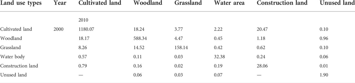
TABLE 3. Results of LUTM in the Chengdu-Chongqing region, 2000–2010 (104 hm2).
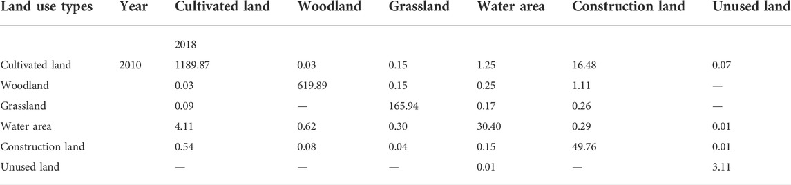
TABLE 4. Results of LUTM in the Chengdu-Chongqing region, 2010–2018 (104 hm2).
Table 3 shows that during the first phase, land use types in the Chengdu-Chongqing region changed significantly during 2000–2010. The transferred size of cultivated land, woodland, grassland, and construction land was larger, while that of water area and unused land was not significant. The transferred areas of cultivated land to woodland and cultivated land to construction land increased to 182,400 hm2 and 204,700 hm2, respectively. The transferred areas of cultivated land to grassland and to water bodies increased to 37,700 hm2 and 22,200 hm2, respectively. Furthermore, the transferred areas of woodland to cultivated land, grassland to cultivated land, and grassland to woodland remained constant at181,700 hm2, 82,600 hm2, and 145,200 hm2, respectively. The transferred areas from woodland to grassland and construction land were 44,700 hm2 and 11,800 hm2, respectively. In summary, the scale of transferred farmland was the largest, while the transferred directions varied. The transferred trends of forest land and grassland were significant, while the transferred scales of water area, construction land, and unused land were smaller. Among all pairwise transfers between different types of land use, that from cultivated land to construction land was the largest.
Table 4 shows that compared to the first phase, the transferred sizes of land use types in the Chengdu-Chongqing region weakened significantly during 2010–2018. Nevertheless, the transferred scale of cultivated land was still the largest among all land use types, and the transferred area from cultivated land to construction land reached 164,800 hm2, which was the largest. The transfer between cultivated land and water area was significant, at 12,500 hm2, while the transferred area from water area to cultivated land was 41,100 hm2. Meanwhile, the transferred area of woodland to construction land was 11,100 hm2.
In summary, in the second phase, the transfer between cultivated and construction land was the major land use transition, although the transferred area was less than that of 181,700 hm2 observed in the first phase (2000–2010). The pairwise transferred scale between other land use types was also smaller in this phase.
3.2 Spatial characteristics of land use transition
This section explores the spatial characteristics, spatial agglomeration characteristics, and transfer rules of land use by using SCG and ESDA. It also summarizes the spatial characteristics of land use transitions in the study area.
3.2.1 Transfer of gravity center (SCG)
SCG was used to gauge the changes in spatial barycenter of land use types in the Chengdu-Chongqing region. Analysis of the migration of the barycenter of land use types can roughly determine the direction of land transfer in this region to summarize the spatial characteristics of land use transitions based on the spatial transferred scale of major land use types in different periods.
The results showed that the distributive gravity centers of cultivated land in the Chengdu-Chongqing region constantly migrated to the northwest from 2000–2018 (Figure 5A). Although the transferred scale of woodland and grassland in this region was not as large as that of cultivated land, the transferred size of woodland and grassland was also enormous.
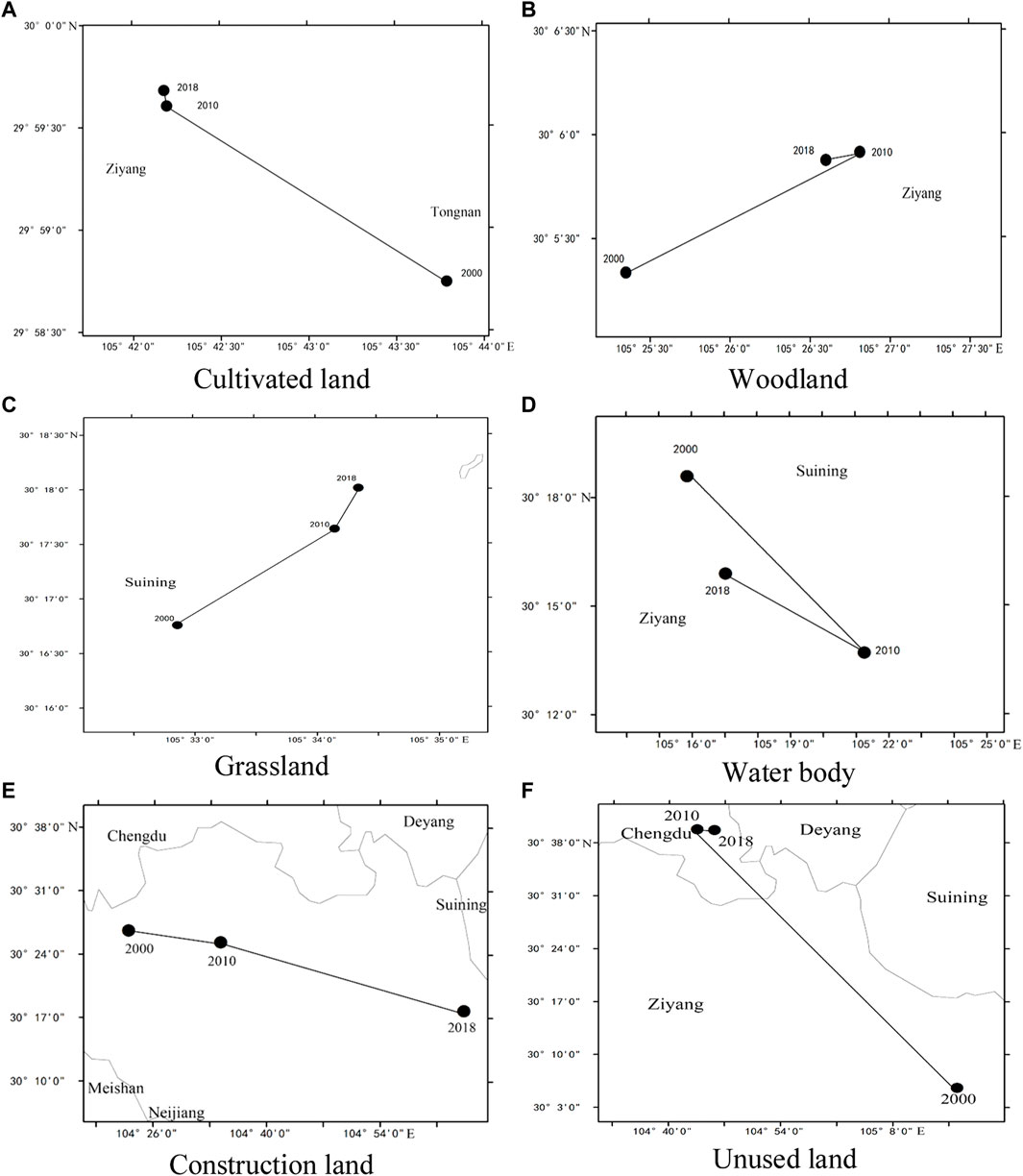
FIGURE 5. (A–F) are respective the changes of the gravity center of cultivated land, woodland, grassland, water body, construction land, and unused land in the study area, 2000–2018.
During 2000–2018, most woodlands were transferred to cultivated land, grassland, and construction land, whilst grassland was mainly transferred to cultivated land and woodland. During 2000–2010, the transfers of land use types were mainly the occupation of cultivated land, woodland, and grassland by construction land. Cultivated land–construction land was mainly distributed in Chengdu, Nanchong, and Yubei. Woodland–construction land was distributed in Zigong and Dazhou. Grassland–construction land was distributed in Kaizhou and Leshan (Figure 6A). During this period, the spatial distribution of woodland changed significantly with its gravity center shifting to the northeast (Figure 5B) due to the large-scale transfers of woodland in Zigong, Rongchang, Dazhou, and other regions (Figure 6A). During 2010–2018, the transfers of land use types involved the occupation of cultivated land by construction land, mainly in the suburbs of Chengdu-Chongqing urban agglomeration due to the rapid extension of urbanization (Figure 6B). In this period, the gravity center of woodland moved to the southwest (Figure 5B) due to the partial migration of woodland in Banan, Chengdu, and other regions. During 2000–2018, the gravity center of grassland constantly moved to the northeast (Figure 5C) due to the large-scale transfer of grassland to cultivated land and woodland in Yaan, Fuling, and Kaizhou and their adjacent areas (Figures 6A,B). During 2000–2010, the gravity center of the water area initially shifted to the southeast but shifted sharply to the northwest during 2010–2018 (Figure 5D). During this period, the gravity center of construction land moved to the southeast (Figure 5E), while the gravity center of unused land first moved to the northwest and then to the southeast (Figure 5F). Overall, the gravity centers of land use types in the Chengdu-Chongqing area changed frequently with different phases of social and economic development.
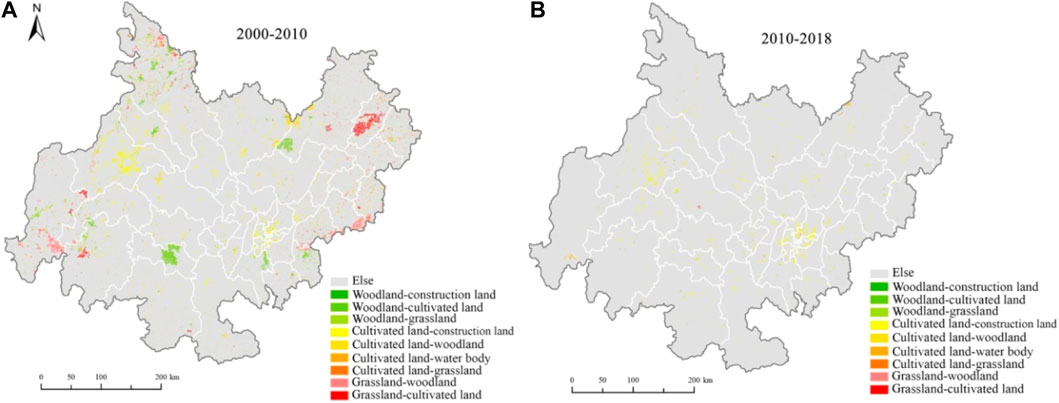
FIGURE 6. (A–B) represents the transfers of land use types of two phases in the Chengdu-Chongqing region.
3.2 2 Spatial correlations of land use types
The results of global autocorrelation analysis indicated that Moran’s Index values increased from 0.6891 in 2000–2010 to 0.8641 in 2010–2018, indicating that the process of land use transition in the Chengdu-Chongqing region was clustered in space. More specifically, the transfer of major land use types showed a strong aggregation in space (Table 5). During 2000–2010, the transfer trend of all land types was spatial aggregation. During 2010–2018, due to the impacts of different drivers, the transfer intensity of land use type was significantly lower and the transfer aggregation of land use type also decreased.
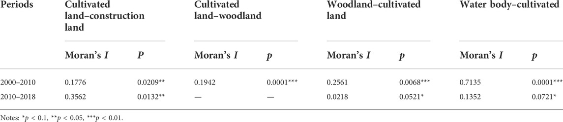
TABLE 5. Global Moran’s Index of the main land type transitions in different phases.
Figure 7 illustrates the significant hot spots of land use transitions in the Chengdu-Chongqing region from 2000–2018. During 2000–2011, the hot spots of land use transitions in this region were mainly distributed in Chengdu, Deyang, Mianyang, and Yubei, indicating the large scale of land use transition and the active change in land use types (Figure 7A). During 2011–2018, due to the weakened land use transition, the transferred scales of cultivated land to construction land and woodland to grassland decreased in the study area and the hot spots of land use transitions in Chengdu decreased significantly (Figure 7B).

FIGURE 7. (A–B) represents the spatial distributions of hot spots of land use transitions of two phase in the Chengdu-Chongqing region.
4 Discussion
4.1 Economic transformation profoundly impacted the land use transition in the region
In the initial phase of the economic transformation, the GDP and urbanization rate in the Chengdu-Chongqing region grew steadily, while the proportions of secondary and tertiary production increased rapidly. During the rapid industrialization and urbanization, many cultivated lands were occupied by construction. Table 3 and Figure 6 show that during 2000–2011, the total area of cultivated land in the Chengdu-Chongqing region decreased by 448,800 hm2, of which 204,700 hm2 was occupied by construction. During the same period, the construction land increased in this area by a total of 225,100 hm2, about 90.94% of which came from occupied farmland. The area of arable land occupied by construction was mainly distributed in the suburbs of Chengdu and Chongqing megacities, as well as Nanchong, which had more rapid urbanization faster and flatter terrain. In this stage, due to the overemphasis on the speed of economic development and urbanization, large numbers of both arable and ecological lands were reduced. During this period, the total woodland area decreased to 252,300 hm2, mainly in Neijiang and Dazhou, and the total grassland area decreased to 239,200 hm2, mainly in Kaizhou and Leshan.
In the accelerated phase of economic transformation, the growth rates of the GDP and urbanization in the Chengdu-Chongqing region slowed and the proportion of secondary industries decreased, while the output value and employment of the tertiary industry continued to increase, which reflected the constant optimization of the industrial structure in this region. During this period, the goal of economic development and urbanization in the Chengdu-Chongqing region changed from extensive growth to high-quality development. Due to the transformation and upgrading of the economic structure and the reduction of resource consumption, the decreased rate of cultivated land in the Chengdu-Chongqing area also slowed compared to the previous phase. Table 4 and Figure 6 show that from 2011–2018, the total reduced area of cultivated land in the Chengdu-Chongqing area was only 179,800 hm2, which was significantly lower than that in the primary stage of economic transformation from 2000–2011. Nevertheless, the cultivated land occupied by construction still accounted for 91.66% of the total decrease, with construction occupation still the main reason for the decrease in cultivated land in this phase. The cultivated land occupied by the construction was mainly distributed in the suburbs of the two megacities, as well as the connecting areas between the two cores. During this phase, due to the emphasis on ecological protection and sustainable development in the economic transformation, the reduction of ecological land in this region slowed significantly. Specifically, the woodland and grassland areas decreased by 15,400 hm2 and 50,200 hm2, respectively, significant reductions compared to those in the previous phase.
Consequently, the different phases of economic transformation show significant differences in the use of cultivated land and the protection of ecological land, which can deeply affect land use transition in the region. In the initial stage of economic transformation, the strong pursuit of rapid economic and urbanization rates can lead to a large reduction of cultivated and ecological lands; thus, the transfer speeds and distances of the center of gravity of cultivated land, woodland, and grassland are relatively large (Figure 5), which leads to unsustainable economic and social development in mountainous areas. During the stage of accelerated economic transformation, socio-economic development relies less on the consumption of traditional elements such as land and labor and more on capital investment and technological progress. Hence, the consumption of land resources is greatly reduced and the transfer speeds and distances of the center of gravity of cultivated land, woodland, and grassland are small (Figure 5). Overall, the socio-economic transformation of mountainous areas profoundly affects the land use transition in these regions.
4.2 Factors influencing the land use transition in the Chengdu-Chongqing region
Some economic and social factors have significantly impacted the different phases of the land use transition in the Chengdu-Chongqing area. As shown in Table 5, the global Moran’s index values of four types of land use transitions in the Chengdu-Chongqing region during 2000–2018 are all >0, implying a potential spatial effect of land use transition; that is, a significant spatial correlation among the transfers of major land use types in the Chengdu-Chongqing area. Hence we used a spatial econometric model to explore the factors influencing the land use transition.
To choose the right model, we first performed OLS by comparing LMlag and LMerror as well as R-LMlag and R-Lmerror. The results showed that LMlag was more statistically significant than LMerror in the transfer of cultivated land to construction land and woodland; therefore, SLM was selected in this transfer. In the transfer of woodland and water area to cultivated land, LMerror was more statistically significant than LMlag. Hence, SEM was chosen for this transfer. The results are shown in Tables 6, 7.
1) During 2000–2010, the Chengdu-Chongqing region was in a stage characterized by rapid economic development and reduced population growth and urbanization rates.
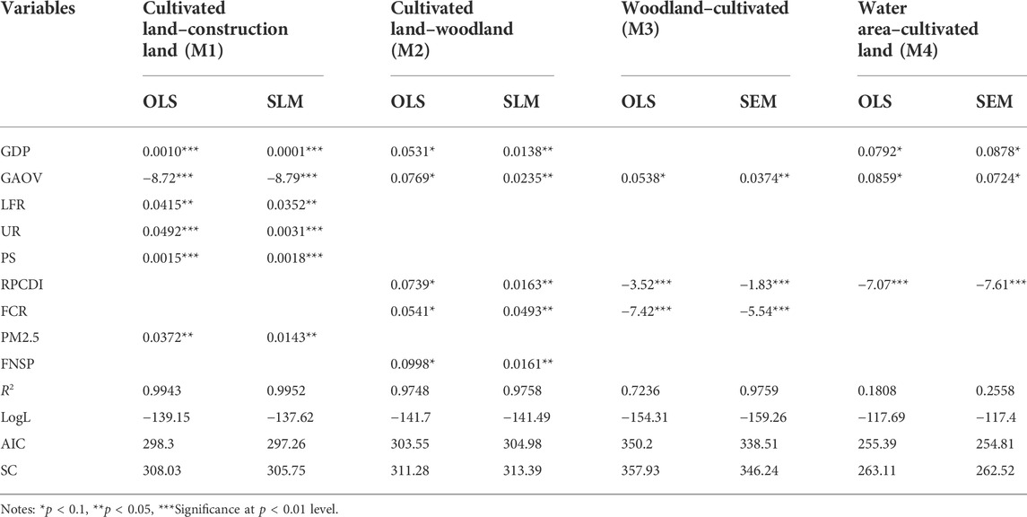
TABLE 6. Factors influencing land use transitions in the study area, 2000–2010.
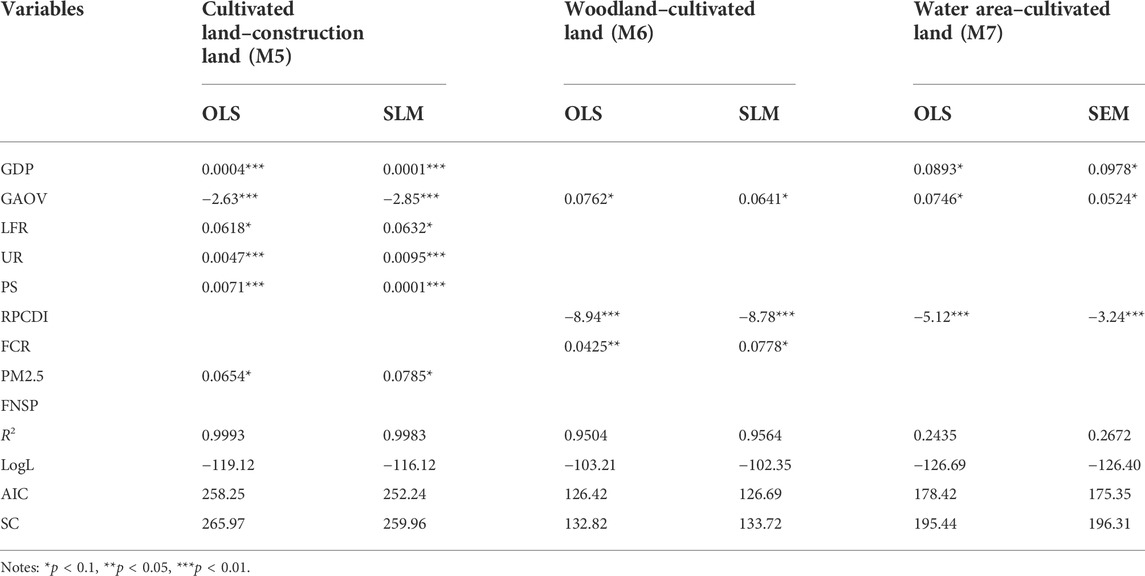
TABLE 7. Factors influencing land use transitions in the study area, 2010–2018.
M1 indicated that the regression coefficient of the transferred area from cultivated to construction land was positive with GDP, local fiscal revenue (LFR), urbanization rate (UR), population size (PS), and PM2.5 concentrations at the 5% confidence level, and negative with gross agricultural output value (GAOP) at the 1% level. Therefore, the growth of GDP, UR, PS, LFR, and PM2.5 were positively associated with the growth of the transferred area from farmland to construction land (Table 6).
During this period, China implemented the Western Development Strategy to develop western China, hence the demand for non-agricultural construction land in this area increased, and much cultivated land was occupied by construction land. Since 2000, rural populations have poured into the Chengdu-Chongqing city conglomeration, leading to the rapid growth of regional urbanization and industrialization. The expansion of cities and the spread of urban industries to rural areas contributed to the transfer from cultivated to construction land. Furthermore, with the expansion of the urban population and the acceleration of urbanization, the demands for urban, rural residential, traffic, and other construction land types increased rapidly, resulting in constant changes in regional land use. The results also showed that the changes in PS were positively correlated with land use transition in this region; that is, the larger the population size, the greater the disturbance to regional land use. The spatio-temporal pattern and structure of land use were reshaped with the population change in the study area. In contrast, with the rapid development of urbanization and industrialization, woodland reduction, urban construction site dust increase, population aggregation, and urban waste incineration destroyed the ecological environment, leading to the continuous rise of PM2.5 levels.
M2 indicated that the areas transferred from cultivated land to woodland were significantly positively correlated with GDP, gross agricultural output value (GAOV), rural per capita disposable income (RPCDI), forest coverage rate (FCR), and fertilizer non-point source pollution (FNSP) at the 5% confidence level. The “returning farmland to forestland” policy initiated in 2003 contributed to the transfer of farmland to woodland. In the context of this policy, farmland with a slope of >25° was converted to forestland, which resulted in a strong positive effect on the conversion of farmland to forest land. After 2007, this program was discontinued and the scale of the transferred area of farmland to woodland and grassland decreased. Furthermore, to alleviate the contradiction between the supply and demand of cultivated land caused by urbanization, China has established a strict system to protect cultivated land to ensure the dynamic stability of the quantity and quality of this land. China implemented projects for land consolidation and ecological restoration to control the supply of cultivated land and protect ecological land, transforming the methods of land use transition in the study area.
M3 and M4 showed that the areas transferred from woodland and water area to cultivated land were significantly positively correlated with GAOV at the 10% level and were negatively correlated with RPCDI at the 1% confidence level. The transfer of woodland to cultivated land was negatively correlated with FCR at the 1% confidence level, while the transfer of water area to cultivated land is significantly positively correlated with GDP at the 10% level. Since 2000, China has performed large-scale ecological restoration projects, such as “returning farmland to forestland” in the Chengdu-Chongqing region, to improve the regional ecological environment, contributing to a decreased cultivated land area. To ensure national food security, China began to implement financial subsidies for grain production in 2004, which encouraged farmers to grow grains and further impacted the structural adjustment of agriculture and land use. In 2005, China put forward a series of policies and measures to enhance agricultural production by increasing farmers’ enthusiasm for agricultural production. To further replenish cultivated land and improve agricultural ecological conditions, China launched land consolidation projects in 2009, which greatly promoted the transfer of woodland to cultivated land.
2) During 2010–2018, the Chengdu-Chongqing region was in a phase of sustained economic growth, with a per-capita GDP above the national average, reduced population growth, and increased urbanization rates.
M5 indicated that during this phase, the regression coefficient of the transferred area from cultivated land to construction land was positive with GDP, LFR, UR, PS, and PM2.5 at the 10% level and negative with GAOV at the 1% level. From 2007–2018, with economic development, the industrial structure of the Chengdu-Chongqing region changed constantly. The proportion of secondary industries decreased, while that of tertiary industries increased, which contributed to the accelerated change in land use patterns in this region. After 2010, with the increasing local government support of emerging industries, the demand for industrial land in the Chengdu-Chongqing region kept increasing due to the acceleration of urbanization and the transformation and upgrades to the regional industrial structure. The demand further aggravated the occupation of cultivated land for construction, increasing the pressure to protect cultivated land (Table 7).
M6 and M7 showed that the transferred areas of woodland and water areas to cultivated land were significantly positively correlated with GAOV at the 10% level and are negatively correlated with RCDI at the 1% confidence level. The transfer of woodland to cultivated land was negatively correlated with FCR at the 10% confidence level, while the transfer of water areas to cultivated land was significantly positively correlated with GDP at the 10% level. In this phase, to ensure regional food security and supplement cultivated land, the Chengdu-Chongqing region carried out more land consolidation projects. Many woodland and water areas were converted to cultivated land. The scale of cultivated land kept expanding and the conflicts between different land use patterns were greatly alleviated.
4.3 Mechanisms of land use transitions in the Chengdu-Chongqing region
The land use transition basically reflects the coordination process of regional man-land relationships; that is, the coupling relationship between economic development and natural resource utilization (Long et al., 2014; Li et al., 2019). The land use transition in the Chengdu-Chongqing region mainly involved the conversion between cultivated land and other land types, especially the transfer from cultivated land to construction land. The transitional quantity and relationship of land use types caused by socio-economic development reflected the potential change in land quantity structures and spatial characteristics in this region. In essence, the regional land use transition is a constant process of spatial evolution from conflict to coordination among different land use types. The root cause of land use conflict lies in the disharmony of land use and an imbalance of land supply and demand caused by rapid development in different phases (Figure 8).
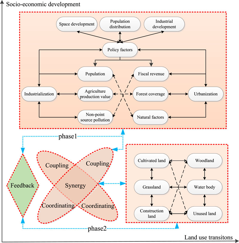
FIGURE 8. Mechanism of land use transitions in the Chengdu-Chongqing region.
The results of the present case study indicated that the land use transition in the Chengdu-Chongqing region was driven by many socio-economic factors. Different factors have different effects on the changes in land supply and demand. One key factor is national policy. National policies have significantly accelerated the speed of urban-rural integration in the Chengdu-Chongqing area, steadily improved the level of economic development, and allowed a more reasonable allocation of land resources. Hence, factors such as policies and institutions have directly driven the development of the economic society and the process of urbanization and industrialization in mountainous China, changing the direction and intensity of different land use transitions (Wu et al., 2022). For example, the policies for cultivated land protection and returning cultivated land to forestland have changed the direction of the transition of cultivated land use. The policy protecting cultivated land has reduced the speed of its transition and maintained its quantity and quality. Conversely, the policy of returning cultivated land to forestland (woodland and grassland) changed the structure of land use. In summary, the policies for national spatial development, population control, and regional industrial layout have disproportionately affected the development of the economy and population and have also contributed to the changes in land use patterns in the context of rapid urbanization and industrialization. Furthermore, due to the impacts of these policies, the contradiction between the protection of the ecological environment and socioeconomic development has exacerbated the imbalance between the supply and demand of land, leading to the large-scale transfers of land use types. For example, a large number of ecological lands are destroyed, resulting in the constant reduction of ecological land, which is not in line with the green and sustainable development advocated by local governments.
The mechanism of land use transition in the Chengdu-Chongqing region is the result not only of policy guidance to alleviate the conflict between ecological and environmental protection and socio-economic development but also the comprehensive effects of nature, the population, and the economy. The rapid growth and diffusion of the population and the acceleration of urbanization promoted the transformation of urban-rural development and changes in regional production and life, leading to the changes in regional land use function that contributed to the transition of land use. Furthermore, the differences in land use demand between ecological protection and spatial development policies have contributed to conflicts between economic development and natural resource protection. Specifically, the construction of infrastructure and the optimization of industrial layout depend heavily on an increased demand for land, while the protection of natural resources depends less on the unrestrained occupation and exploitation of land. The mechanism of land use transition in the Chengdu-Chongqing region results from the mutual dependence and restriction between natural and socio-economic factors, as well as a dynamic coupling process.
4.4 Limitations and prospects
Due to the guidance of regional policies, the industrialization and urbanization of mountainous areas have developed rapidly, and large amounts of cultivated land and woodland have been transformed into construction land. To maintain the dynamic balance of cultivated land, the Chengdu-Chongqing region reclaimed rural idle construction land to increase the cultivated land area, aiming to achieve the urban construction quota by compressing rural idle construction land. Although this measure alleviated the contradiction in the spatial allocation of land uses, it produced the spatial concurrence of land use in this region due to the mountainous terrain. Consequently, methods for alleviating the spatial conflict of “ecology, production and living” of land use should become a priority in future studies on the land use transition in the Chengdu-Chongqing region.
Furthermore, land use transitions generally involve not only the explicit transition of land quantity and spatial structure but also the implicit transition of land use function (Ge et al., 2018; Chen et al., 2020). Due to the unavailability of data, we only examined the dominant form of land use transition in the Chengdu-Chongqing region, including the spatial and structural transitions of land use types. If future studies can gather related tightness data, we can better gauge the comprehensive process and mechanism of land use transition in the Chengdu-Chongqing region at a larger spatio-temporal level.
5 Conclusion
This study examined the typical characteristics and mechanisms of the land use transition in the mountainous Chengdu-Chongqing region in southwestern China. Our findings indicated that with the development of socio-economic transformation since 2000, the Chengdu-Chongqing region has experienced a deep structural transition in land use. Specifically, during 2000–2018, the cultivated land area decreased, while the construction land area increased primarily from the transfer of cultivated land to construction land. The areas of woodland and unused land fluctuated, while the areas of grassland and water bodies decreased slightly. From 2000 to 2010, the land use types in the Chengdu-Chongqing region changed significantly, with a predominant transfer from cultivated land to construction land in the study area. However, compared to the period 2000–2011, the transferred scale of land use types in the Chengdu-Chongqing region weakened significantly from 2011 to 2018. The Chengdu-Chongqing region has also experienced a deep spatial transition in land use since 2000. Specifically, the gravity center of land use types in the region changed frequently with time. The gravity center of cultivated land moved northwest, while that of woodland moved northeast first and then southwest, that of grassland moved northeast constantly, that of water body moved southeast first and then northwest and that of unutilized land moved northwest. Land use transitions in the Chengdu-Chongqing region showed significant spatial aggregation in different phases. During 2000–2010, the land use transitions in Chengdu, Deyang, Mianyang, and Yubei showed large-scale spatial agglomerations, whilst the rest of the land use transitions showed small-scale spatial agglomerations. During 2010–2018, land use transitions in the northeastern Chengdu-Chongqing region and the Deyang, Meishan, and Luzhou regions showed small-scale agglomerations.
The socio-economic transformation of the Chengdu-Chongqing region has profoundly affected its land use transition, which was reflected in the structural and spatial transitions of land use in different transformation phases; moreover, its essence is the change in the demand for land use caused by economic transformation. Specifically, in the initial phase of economic transformation, the unilateral pursuit of rapid economic and urbanization development likely leads to reductions in cultivated and ecological land, which manifest in the larger transfer speed and distance of the center of gravity in cultivated land, woodland, and grassland, as well as in the accelerated phase of economic transformation, economic, and social development, which no longer rely solely on the consumption of traditional elements such as land and labor but rather increasingly rely on capital investment and technological progress. Thus, the consumption of land resources is greatly reduced, and the transfer speed and distance of the center of gravity of cultivated land, woodland, and grassland decreases.
Overall, this study provides a comprehensive overview of the mechanism and underlying impacts of land use transitions in the mountainous Chengdu-Chongqing region. Specifically, the growth of construction land in this region was significantly impacted by the amount of available resources, economic growth, urbanization rate, population migration, and policies. With the expansion of regional economic differences, economic growth and industrial structure evolution play crucial roles in the transition of construction land. The transfers from cultivated land to woodland and grassland are primarily affected by the policy for land use and ecological protection.
In summary, the land use transition in the Chengdu-Chongqing region was a process from conflict to coordination guided by national and regional policies. The conflict in this process was mainly due to the change in land supply and demand caused by regional economic activities. The quantity of land supply in the Chengdu-Chongqing region depends heavily on the land use policies for living, production, and ecology. Land demand aims to meet the needs for socio-economic development, which are indirectly regulated by policies for spatial development, population control, and regional industrial layout. The land use transition in the Chengdu-Chongqing region is a dynamic coupling system resulting from the interdependence and restriction of natural conditions, the social economy, and the policy systems. The methodology and conclusions of this study also provide a valuable reference for the study of land use transitions in mountainous economic zones undergoing different phases in other developing countries.
Data availability statement
The original contributions presented in the study are included in the article/Supplementary Material. Further inquiries can be directed to the corresponding authors.
Author contributions
ZW contributed to the original draft. HY and LZ contributed to the methods.
Funding
This research was partly supported by the National Natural Science Foundation of China (Award # 42271280) and National Social Science Foundation of China (Award # 20BJY120).
Acknowledgments
The authors thank the funder for their support.
Conflict of interest
The authors declare that the research was conducted in the absence of any commercial or financial relationships that could be construed as a potential conflict of interest.
Publisher’s note
All claims expressed in this article are solely those of the authors and do not necessarily represent those of their affiliated organizations, or those of the publisher, the editors, and the reviewers. Any product that may be evaluated in this article, or claim that may be made by its manufacturer, is not guaranteed or endorsed by the publisher.
References
Burra, D. D., Parker, L., Than, N. T., Phonepaseuth, P., Long, C. T. M., Ritzema, R. S., et al. (2021). Drivers of land use complexity along an agricultural transition gradient in Southeast Asia. Ecol. Indic. 124, 107402. doi:10.1016/j.ecolind.2021.107402
Chen, H. X., Chen, C., Zhang, Z. L., Lu, C., Wang, L. Y., He, X. Y., et al. (2021). Changes of the spatial and temporal characteristics of land-use landscape patterns using multi-temporal landsat satellite data: A case study of zhoushan island, China. Ocean Coast. Manag. 213, 105842. doi:10.1016/j.ocecoaman.2021.105842
Chen, K. Q., Long, H. L., Liao, L. W., Tu, S. S., and Li, T. T. (2020). Land use transitions and urban-rural integrated development: Theoretical framework and China’s evidence. Land Use Policy 92, 104465. doi:10.1016/j.landusepol.2020.104465
Czekajlo, A., Coops, N. C., Wulder, M. A., Hermosilla, T., White, J. C., and van den Bosch, Matilda (2021). Mapping dynamic peri-urban land use transitions across Canada using Landsat time series: Spatial and temporal trends and associations with socio-demographic factors. Comput. Environ. Urban Syst. 88, 101653. doi:10.1016/j.compenvurbsys.2021.101653
Delbecque, N., Dondeyne, S., Gelaude, F., Mouazen, A. M., Vermeir, P., and Verdoodt, A. (2022). Urban soil properties distinguished by parent material, land use, time since urbanization, and pre-urban geomorphology. Geoderma 413, 115719. doi:10.1016/j.geoderma.2022.115719
Dou, Y., Luo, X., Dong, L., Wu, C., Liang, H. W., and Ren, J. Z. (2016). An empirical study on transit-oriented low-carbon urban land use planning: Exploratory Spatial Data Analysis (ESDA) on Shanghai, China. Habitat Int. 53, 379–389. doi:10.1016/j.habitatint.2015.12.005
Esposito, G., Clement, J., Mora, L., and Crutzen, N. (2021). One size does not fit all: Framing smart city policy narratives within regional socio-economic contexts in Brussels and Wallonia. Cities 118, 103329. doi:10.1016/j.cities.2021.103329
Feng, R. D., Wang, F. Y., Zhou, M. J., Liu, S. H., Qi, W., and Li, L. (2022). Spatiotemporal effects of urban ecological land transitions to thermal environment change in mega-urban agglomeration. Science of the Total Environment, 156158.
Ge, D. Z., Long, H. L., Zhang, Y. N., Ma, L., and Li, T. T. (2018). Farmland transition and its influences on grain production in China. Land Use Policy 70, 94–105. doi:10.1016/j.landusepol.2017.10.010
Grainger, A., Francisco, H. A., and Tiraswat, P. (2003). The impact of changes in agricultural technology on long-term trends in deforestation. Land Use Policy 20 (3), 209–223. doi:10.1016/s0264-8377(03)00009-7
Grainger, A. (1986). The future role of the tropical rain forests in the world forest economy. Oxford: Department of Plant Sciences, University of Oxford.
Guo, Y. Z., and Liu, Y. S. (2021). Poverty alleviation through land assetization and its implications for rural revitalization in China. Land Use Policy 105, 105418. doi:10.1016/j.landusepol.2021.105418
Herrick, J. E., Shaver, P., Pyke, D. A., Pellant, M., Toledo, D., and Lepak, N. (2019). A strategy for defining the reference for land health and degradation assessments. Ecol. Indic. 97, 225–230. doi:10.1016/j.ecolind.2018.06.065
Kresse, K., and van der Krabben, E. (2022). Rapid urbanization, land pooling policies & the concentration of wealth. Land Use Policy 116, 106050. doi:10.1016/j.landusepol.2022.106050
Kuwil, F. H., Atila, Ü., Abu-Issa, R., and Murtagh, F. (2020). A novel data clustering algorithm based on gravity center methodology. Expert Syst. Appl. 156, 113435. doi:10.1016/j.eswa.2020.113435
Li, L., Ma, S. J., Zheng, Y. L., and Xiao, X. Y. (2022). Integrated regional development: Comparison of urban agglomeration policies in China. Land Use Policy 114, 105939. doi:10.1016/j.landusepol.2021.105939
Li, Y. R., Li, Y., Fan, P. C., and Long, H. L. (2019). Impacts of land consolidation on rural human–environment system in typical watershed of the Loess Plateau and implications for rural development policy. Land Use Policy 86, 339–350. doi:10.1016/j.landusepol.2019.04.026
Liu, J. J., Wang, J., Zhai, T. L., Li, Z. H., Huang, L. Y., and Yuan, S. H. (2021). Gradient characteristics of China's land use patterns and identification of the east-west natural-socio-economic transitional zone for national spatial planning. Land Use Policy 109, 105671. doi:10.1016/j.landusepol.2021.105671
Liu, Y. S., Liu, Y., Chen, Y. F., and Long, H. L. (2010). The process and driving forces of rural hollowing in China under rapid urbanization. J. Geogr. Sci. 20 (6), 876–888. doi:10.1007/s11442-010-0817-2
Liu, Y. S., Yang, R., and Li, Y. H. (2013). Potential of land consolidation of hollowed villages under different urbanization scenarios in China. J. Geogr. Sci. 23, 503–512. doi:10.1007/s11442-013-1024-8
Long, H. L., Liu, Y. Q., Hou, X. G., Li, T. T., and Li, Y. R. (2014). Effects of land use transitions due to rapid urbanization on ecosystem services: Implications for urban planning in the new developing area of China. Habitat Int. 44, 536–544. doi:10.1016/j.habitatint.2014.10.011
Long, H. L., and Qu, Y. (2018). Land use transitions and land management: A mutual feedback perspective. Land Use Policy 74, 111–120. doi:10.1016/j.landusepol.2017.03.021
Long, H. L., Tang, G. P., Li, X. B., and Heilig, G. K. (2007). Socio-economic driving forces of land-use change in Kunshan, the Yangtze River Delta economic area of China. J. Environ. Manag. 83 (3), 351–364. doi:10.1016/j.jenvman.2006.04.003
Mahmoud, M., and Vogt, J. (2021). Socio-economic transformation in rural areas: From agriculture to limestone in a Coptic village in middle Egypt. Extr. Industries Soc. 8 (3), 100946. doi:10.1016/j.exis.2021.100946
Mather, A. S., Fairbairn, J., and Needle, C. L. (1999). The course and drivers of the forest transition: The case of France. J. Rural. Stud. 15, 65–90. doi:10.1016/s0743-0167(98)00023-0
Nuissl, H., Haase, D., Lanzendorf, M., and Wittmer, H. (2009). Environmental impact assessment of urban land use transitions—A context-sensitive approach. Land Use Policy 26, 414–424. doi:10.1016/j.landusepol.2008.05.006
Ojoyi, M. M., Mutanga, O., Odindi, J., Kahinda, J.-M. M., and Abdel-Rahman, E. M. (2017). Implications of land use transitions on soil nitrogen in dynamic landscapes in Tanzania. Land Use Policy 64, 95–100. doi:10.1016/j.landusepol.2017.02.023
Petrescu-Mag, R. M., Petrescu, D. C., and Azadi, H. (2022). From scythe to smartphone: Rural transformation in Romania evidenced by the perception of rural land and population. Land Use Policy 113, 105851. doi:10.1016/j.landusepol.2021.105851
Qu, Y., and Long, H. L. (2018). The economic and environmental effects of land use transitions under rapid urbanization and the implications for land use management. Habitat Int. 82, 113–121. doi:10.1016/j.habitatint.2018.10.009
Seitzinger, S. P., Gaffney, O., Brasseur, G., Broadgate, W., Ciais, P., Claussen, M., et al. (2015). International geosphere–biosphere programme and earth system science: Three decades of co-evolution. Anthropocene 12, 3–16. doi:10.1016/j.ancene.2016.01.001
Stech, H., Peckham, B., and Pastor, J. (2012). Enrichment in a general class of stoichiometric producer–consumer population growth models. Theor. Popul. Biol. 81 (3), 210–222. doi:10.1016/j.tpb.2012.01.003
Swette, B., and Lambin, E. F. (2021). Institutional changes drive land use transitions on rangelands: The case of grazing on public lands in the American West. Glob. Environ. Change 66, 102220. doi:10.1016/j.gloenvcha.2020.102220
Tan, Y. Z., Chen, H., Xiao, W., Meng, F., and He, T. T. (2021). Influence of farmland marginalization in mountainous and hilly areas on land use changes at the county level. Sci. Total Environ. 794, 149576. doi:10.1016/j.scitotenv.2021.149576
Tian, J. F., Wang, B. Y., Zhang, C. R., Li, W. D., and Wang, S. J. (2020). Mechanism of regional land use transition in underdeveloped areas of China: A case study of northeast China. Land Use Policy 94, 104538. doi:10.1016/j.landusepol.2020.104538
Wang, Y. H., Li, X. B., Lu, D., and Yan, J. Z. (2020a). Evaluating the impact of land fragmentation on the cost of agricultural operation in the southwest mountainous areas of China. Land Use Policy 99, 105099. doi:10.1016/j.landusepol.2020.105099
Wang, Y. H., Li, X. B., Xin, L. J., and Tan, M. H. (2020b). Farmland marginalization and its drivers in mountainous areas of China. Sci. Total Environ. 719, 135132. doi:10.1016/j.scitotenv.2019.135132
Wu, Y. Z., Long, H. L., Zhao, P. J., and Hui, E. C. M. (2022). Land use policy in urban-rural integrated development. Land Use Policy 115, 106041. doi:10.1016/j.landusepol.2022.106041
Xiang, J. W., Li, X. M., Xiao, R. B., and Wang, Y. (2021). Effects of land use transition on ecological vulnerability in poverty-stricken mountainous areas of China: A complex network approach. J. Environ. Manag. 297. doi:10.1016/j.jenvman.2021.113206
Xing, L., Hu, M. S., and Xue, M. G. (2022). The effect of urban–rural construction land transition on ecosystem services: A theoretical framework and empirical evidence for China. Habitat Int. 124, 102576. doi:10.1016/j.habitatint.2022.102576
Xu, H. T., Song, Y. C., and Tian, Y. (2022). Simulation of land-use pattern evolution in hilly mountainous areas of north China: A case study in jincheng. Land Use Policy 112, 105826. doi:10.1016/j.landusepol.2021.105826
Xu, M. Y., and Zhang, Z. F. (2021). Spatial differentiation characteristics and driving mechanism of rural-industrial land transition: A case study of beijing-tianjin-hebei region, China. Land Use Policy 102, 105239. doi:10.1016/j.landusepol.2020.105239
Zhang, Q, Q., Wang, Y., Tao, S. Q., Bilsborrow, R. E., Qiu, T., Liu, C., et al. (2020). Divergent socioeconomic-ecological outcomes of China’s conversion of cropland to forest program in the subtropical mountainous area and the semi-arid Loess Plateau. Ecosyst. Serv. 45, 101167. doi:10.1016/j.ecoser.2020.101167
Zhang, Y. N, Y. N., Long, H. L., Li, Y. R., Ge, D. Z., and Tu, S. S. (2020). How does off-farm work affect chemical fertilizer application? Evidence from China’s mountainous and plain areas. Land Use Policy 99, 104848. doi:10.1016/j.landusepol.2020.104848
Zhou, Y., Li, X. H., and Liu, Y. S. (2020). Land use change and driving factors in rural china during the period 1995-2015. Land Use Policy 99, 105048. doi:10.1016/j.landusepol.2020.105048
Keywords: explicit land transition, characteristics and mechanisms of land use transition, mountainous economic zone, Chengdu-Chongqing region, southwestern China
Citation: Wang Z, Ye H and Zhang L (2022) Understanding the characteristics and mechanism of land use transition in mountainous economic zone: A case study of the Chengdu-Chongqing region in southwestern China. Front. Environ. Sci. 10:963197. doi: 10.3389/fenvs.2022.963197
Received: 09 June 2022; Accepted: 29 August 2022;
Published: 23 September 2022.
Edited by:
Salvador García-Ayllón Veintimilla, Technical University of Cartagena, SpainReviewed by:
Xiaofeng Wang, Chongqing Normal University, ChinaMaros Finka, SPECTRA CE EU at STU in Bratislava, Slovakia
Copyright © 2022 Wang, Ye and Zhang. This is an open-access article distributed under the terms of the Creative Commons Attribution License (CC BY). The use, distribution or reproduction in other forums is permitted, provided the original author(s) and the copyright owner(s) are credited and that the original publication in this journal is cited, in accordance with accepted academic practice. No use, distribution or reproduction is permitted which does not comply with these terms.
*Correspondence: Zhaolin Wang, d2FuZ3pobEBjdGJ1LmVkdS5jbg==; Luyang Zhang, emhhbmdsdXlhbmc2MjRAMTI2LmNvbQ==