 Cheng Gao
 Manqiu Hao1*
- 1College of Hydrology and Water Resources, Hohai University, Nanjing, China
- 2Yantai Hydrographic Bureau, Yantai, China
- 3Information Center, Ministry of Water Resources, Beijing, China
- 4School of Geography and Planning, Sun Yat-sen University, Guangzhou, China
- 5Nanjing Branch of Jiangsu Province Hydrology and Water Resources Investigation Bureau, Nanjing, China
- 6Nanjing Water Group, Nanjing, China
As the social economy is further developed, there have been increasingly severe ecological and environmental issues. For instance, rivers located in mountainous areas are often encountered with the issue of zero flow. The ecological base flow was put forward to ensure the continuous flow of rivers, to realize the minimum ecological function, and to meet the most fundamental requirements of sustaining the river ecosystem. Wulong River Basin in Yantai City of China was taken as example here. Based on the runoff data collected in the Tuanwang Hydrological Station from 1960 to 2016, the measured runoff data was restored to natural runoff sequence by adopting the item-by-item investigation method. The different ecological base flows of Wulong River were calculated by adopting the Tennant Method, the Qp90 Method, the Texas Method, the Base Flow Ratio Method, the Tessman Method, and Wetted Perimeter Method. The research findings have shown that the Base Flow Ratio Method proves to be the optimal approach for calculating the ecological base flow of Wulong River. Based on the analysis of the assurance degree of ecological base flow, the period from April to June is the period with the lowest assurance degree of ecological base flow.
Introduction
Keeping enough flowing water in the river is the premise of maintaining the basic ecological function of the river and the basis of ensuring the stability and dynamic balance of the ecosystem. This flow is defined as ecological base flow. Therefore, a certain basic flow should be reserved to prevent the river from cutting off or shrinking during the development of water resources. Human activities and the construction of water conservancy engineering facilities have reduced the self- repair ability of natural rivers, and the ecological environment of rivers has been damaged (Liu et al., 2020; Chen et al., 2021). In addition, the sustainability of natural rivers has been greatly affected by the over exploitation of water resources such as agricultural irrigation. Therefore, it is of practical significance to study and determine the ecological base flow of rivers.
Studies on the calculation of ecological base flow of rivers began in the 1940s and have experienced rapid developments since the 1970s. Judging from the statistics of 2003, over 200 methods are available for estimating the ecological water demands of the river. These methods are mainly divided into four categories, namely, the Hydrological Index Method, the Hydraulics Method, the Integral Analysis Method, and the Habitat Method (Sakke et al., 2018; Zhang et al., 2022). In addition, there are a few calculation methods other than the aforementioned approaches (Tharme, 2003). Hydrological method is based on observation data and mathematical statistical analysis, and most rivers in China have a long series of hydrological data, so it is efficient and simple. By analyzing the applicability of the four major methods, Zhong et al. (2006) believes that the Hydrological Index Method is the optimal method for studying the rivers in China. Given that the studies on ecological base flow began late in China, domestic scholars have mostly adopted overseas methods during the early stage (Zhang and Xiong, 2017; Singh et al., 2019; Chacko et al., 2021). Subsequently, some domestic scholars have improved their calculation methods based on the actual circumstances of the study area. For instance, Lin (2017) adopted the overclocking method to avoid the impact imposed by extreme events. Yang et al. (2016) resorted to the optimized method of hydrograph to improve the measured flow data, which can be directly applied to rivers subject to the influence of human activities. Wu et al. (2011) took into account of the process of annual runoff and the disparity between high flow, normal flow and low flow years, and adopted the Base Flow Ratio Method to calculate the ecological base flow. Huang et al. (2007) introduced the seasonal coefficient and the environmental gradient ration to reveal the silt-laden and seasonal features of the Yellow River. Liu et al. (2007) developed the Ecological Hydraulic Radius Model, avoiding the uncertainty derived from the calculation of the catastrophe point via the Wetted Perimeter Method. Neubauer et al. (2008) developed a minimum flows and levels (MFLs) method to simulate long-term system hydrology. Based on the features of seasonal rivers and the principle of determining ecological flow, Yang and Zhang (2018) measured the ecological flow of the river by stages, which effectively addressed the contradiction between ecological and economic uses of water. Huang et al. (2019) took into account the influence of hydrological variation and identified the significant impact imposed by water conservancy projects on ecological water level. Through the comparative analysis of the calculation results of each method, the suitable calculation method of the reach is selected and the ecological base flow value of each month is determined. The calculation results can provide reference for ecological management and protection of this river.
Overview of the study area
Yantai City is located in the east of Jiaodong Peninsula, and the city’s GDP ranks third in Shandong Province. With the per capita water resource amounting to less than 1/5 of that of China nationwide, Yantai City is faced with the severe shortage of water resources. The ecological water demands of local rivers can hardly be satisfied for a long time, and the local ecological environment is deteriorating increasingly. According to the survey of freshwater fish resources in Shandong Province (Cao et al., 2013), there are less than 10 freshwater fish species in Yantai City and its subordinate counties, ranking in the bottom of Shandong Province. It is necessary to properly allocate water resources and develop unconventional water sources in Yantai City, so as to meet the ecological water demands for both production and daily life. In this respect, the calculation of ecological base flow lays the foundation for relevant work.
In Yantai City, the local rivers are all mountainous ones and streams fed by rainwater, with the small basin, short river channel and often cutoff flow. In addition, the river channel cross-section is typically wide and shallow. In the region, the rivers with large basin areas include Huangshui River, Dagujia River and Wulong River, which all find their way to the sea. Due to the increase of water diversion and storage capacity, these rivers are faced with the no-flow issue on a frequent basis.
In this study, Wulong River Basin was selected, the largest basin, in Yantai City, as the research object. The basin (illustrated in Figure 1), a low mountainous and hilly area, lies in the central part of Jiaodong Peninsula. It features a main stream length of 130 km and a basin area of 2,810 km2. The annual average precipitation amounts to 698.1 mm, whereas the precipitation in the flood season accounts for 74.1% of the annual precipitation, which mostly takes place as rainstorm. Since the 1980s, the basin has been encountered with zero flow for numerous times, and the ecological environment of the river has increasingly deteriorated.
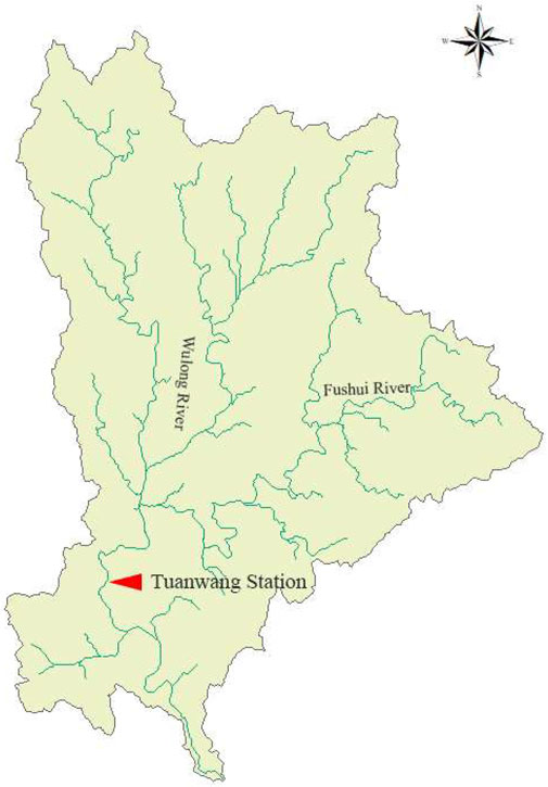
FIGURE 1. Wulong river basin.
Data of the study area
In this study, Tuanwang Hydrological Station locates in the Wulong River basin, of which control basin area amounts to 2,445 km2, accounting for 87.6% of the total basin area. Established in 1951, the Tuanwang Hydrological Station has collected the measured runoff data on a consecutive monthly scale from 1960 to 2016. Given that the runoff process in the basin is subject to significant impact imposed by human activities, it is necessary to conduct reduction calculation of the natural runoff.
Materials and methods
Natural runoff restoration
Given that the runoff process in the basin is subject to significant impact imposed by human activities, the measured runoff sequence is inconsistent. Therefore, it is necessary to conduct restoration calculation (Li and Wei, 2015; Zhang et al., 2019; Quan et al., 2021).
The item-by-item investigation method was adopted during the reduction of runoff. This method is based on the results of multiple hydrological surveys, and the water balance Equation 1 is applied to reduce the measured runoff sequence of the Tuanwang Hydrological Station from 1960 to 2016 to natural runoff sequence, which helps to reduce the impact imposed by various sorts of projects on natural runoff. Although the alteration of the underlying surface could also impose an impact on the formation of runoff, such impact on the study area is too limited to take into account during the reduction calculation,
where, WN refers to the reduced natural runoff; WM refers to the measured runoff; Wi refers to the reduction amount, including the loss derived from agricultural irrigation, industrial water use and urban living water use, the variable of reservoir water storage, the cross-basin (or cross-section) water diversion and the river flood diversion and flood loss of dam breach.
Methods of ecological base flow
1) Tennant Method. Researchers take a certain percentage (usually ranging between 10% and 30%) of the annual average natural runoff as the ecological base flow (Men and Liu, 2008; Li and Kang, 2014). When the percentage reaches 10%, the basic ecological function could be guaranteed for the river. When the percentage reaches 30%, a better habitat could be formed for the majority of creatures (Zhong et al., 2006; Tennant, 2011). In this study, in order to take into account the seasonal variation of river flow in the study area, the seasonal coefficient was given accordingly.
where, QDi refers to the monthly average flow of a typical year, QT refers to the annual average flow of multiple years under natural conditions, whereas the average value of multiple normal flow years is selected as the value of the typical year.
Description of river flow through the improved Tennant Method is shown in Table 1.
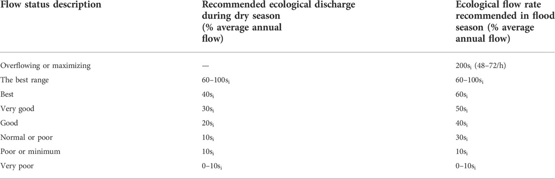
TABLE 1. Description of river flow through the improved tennant method.
2) Base Flow Ratio Method. The varying hydrological years could be divided into wet years, normal years, dry years and extremely dry years. In addition, based on the water conditions in different periods of the year, a specific year could be divided into high flow period, normal flow period and low flow period. Subsequently, the base flow ratios were calculated in varying periods, and Base Flow Ration Method was proposed (Wu et al., 2011).
Ecological base flow can be calculated by the following equations,
where, Ti refers to the known base flow ratio of typical year i; i refers to 1, 2, 3, 4, correspondingly to wet year, normal year, dry year and extremely dry year, usually Ti+1 > Ti; Qi refers to the average discharge of typical year I;μ refers to reduction coefficient, here is 0.4 (Arthington et al., 2006).
3) Qp90 Method. Based on the long-term runoff serials of natural monthly average flow, the average flow of the driest month of each year was selected and its frequency was obtained accordingly. In addition, the frequency at 90% of the driest month was chosen as the minimum ecological water demand. For seasonal rivers, the no-flow period caused by seasonal factors is excluded.
4) Wetted Perimeter Method. The relationship curve between wetted perimeter and the runoff was established (Ji et al., 2010). The flow in the vicinity of the inflection point of the curve represents the minimum ecological water demand. There are mainly two methods for determining the inflection point, namely, the Maximum Curvature Method and the Slope Method. The slope method may have subjective defects in determining the inflection point, while the maximum curvature method can avoid such defects and objectively determine the ecological base flow (Song et al., 2007).
5) Texas Method (Yu et al., 2013). In general, researchers select a certain percentage of the monthly runoff with the guaranteed rate of 50% as the ecological base flow, whereas 20% of monthly runoff is selected for the northern river.
6) Tessman Method (Karakoyun et al., 2016). The ecological base flow was calculated based on the ratio of monthly average flow to annual average flow. When the method is applied, the following three requirements should be followed.
1) When the monthly average flow amounts to less than 40% of the annual average flow, then the monthly average flow would be taken as the ecological base flow;
2) When the monthly average flow amounts to over 40% of the annual average flow, then 40% of the annual average flow would be taken as the ecological base flow;
3) When the monthly average flow exceeds the annual average flow, then 40% of the monthly average flow would be taken as the ecological base flow.
Result analysis
Restoration of runoff sequence
The measured runoff sequence of the Tuanwang Hydrological Station was restored to natural runoff sequence by adopting the item-by-item investigation method. The results of reduction are specified in Table 2.

TABLE 2. Comparison of the measured runoff and reduced runoff in 1960–2016 (Unit: million m³).
Subsequent to the application of the method, the reduced runoff has experienced significant increases compared with the measured runoff. The measured runoff is 67.52 million m3 less than the natural runoff, accounting for 15% of the total. If the measured runoff is taken to calculate the ecological base flow, such calculation would eventually result in huge errors.
Analysis of results of the ecological base flow
The Tennant Method is the most commonly used method for calculating the ecological base flow. For instance, Wang et al. (2017) adopted this method to determine the annual ecological base flow of the Tuanwang Hydrological Station. The annual ecological water demand amounted to 49.53 million m3, and variation existed between the flood season and the non-flood season. This study has taken into account the impact imposed by seasonal factors. Based on the Tennant Method, the seasonal coefficient was used to calculate the ecological base flow in different periods, and the approach is used as a reference for the calculation results of other methods.
Reduction coefficient μ is much more important while using Base Flow Ratio Method. In this study, 20% of the base flow ratio in the wet year was adopted to calculate the base flow ratio of other types of years, according to the range value of Tennant Method (Wu et al., 2011). Each μ was obtain by Eq. 3 in Table 3.
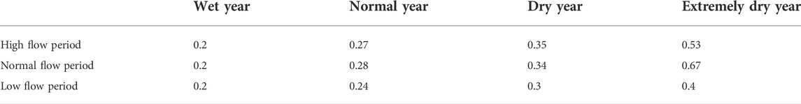
TABLE 3. Reduction coefficient (μ) in different typical years.
Other four additional methods were selected to calculate the ecological base flow of Tuanwang Hydrological Station. The results are specified in Table 4.
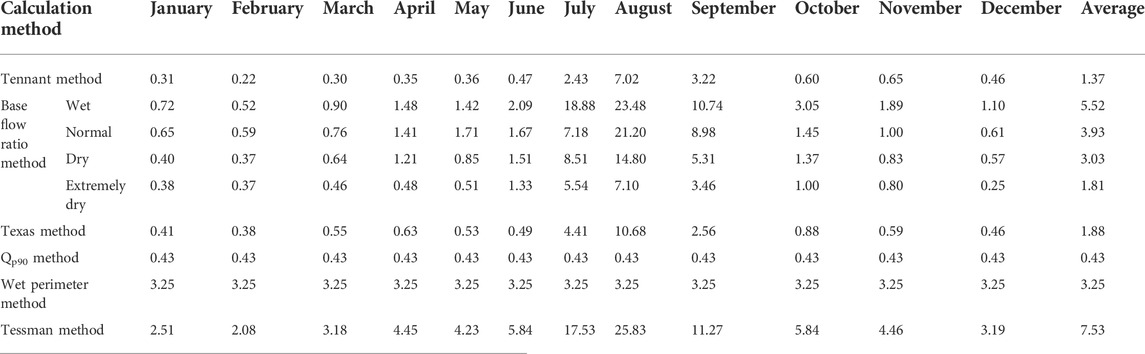
TABLE 4. Results of the ecological base flow with different calculation methods (Unit: m³/s).
The results show that the use of different calculation methods could lead to varying results of the ecological base flow to some extent. The values of ecological base flow calculated by Tennant method, Qp90 Method, Base Flow Ratio Method and Texas Method are smaller. These four methods can be preferred in areas with relatively less water resources. The ecological base flow calculated by Wetted Perimeter Method and Tessman Method is larger, which is suitable for determining ecological base flow in rivers with sufficient water resources. Judging from the flow in the flood season and the non-flood season, the ecological base flow calculated with the Qp90 Method and the Wetted Perimeter Method are often used as the minimum ecological base flow, failing to reflect the intra-annual variation of ecological base flow. Tennant Method has shown better results in that it has taken into account the impact imposed by seasonal factors and the seasonal coefficient was used to calculate the ecological base flow in high flow period and in dry season separately. The Base Flow Ratio Method, the Texas Method and the Tessman Method are adopted to calculate the ecological base flow based on monthly data, which can better reflect the varying results of the ecological base flow in different months. Judging from the annual flow hydrograph, the Base Flow Ratio Method and the Tessman Method are the optimal approaches, which are able to reflect the evident rising and falling water processes during the year. However, the base flow ratio method can better reflect the intra-annual variation of ecological base flow. Judging from the results of the calculation of ecological base flow, the value calculated by the Tennant Method is the smallest, indicating that the value deduced by other methods can meet the requirements of ecological base flow. However, the ecological base flow measured by the Qp90 Method amounts to 0.43 m3/s, which can merely be used as the minimum ecological flow to ensure the continuous flow of the river in the low water period, while failing to satisfy the other ecological functions of the river in the flood season. The ecological base flow measured by the Wetted Perimeter Method amounts to 3.25 m3/s, larger than the annual average flow in low flow period, which is unsuitable for the minimum ecological base flow. The ecological base flow measured by the other three methods is larger than that calculated with the Tennant Method. Specifically, the calculation results based on the Tessman Method are too large due to the influence of extreme value, and given that the study area is faced with water resource constraints, it is unsuitable to adopt the Tessman Method.
Additionally, significant differences exist in the flow of Wulong River basin among different target years. Therefore, rather than being the same for different target years, the ecological base flow ought to correspond with the variation for the varying years. The ecological base flow calculated with the Tennant Method proves to be comparable to that of the extremely dry year deduced by the Base Flow Ratio Method. The results for different target years based on the latter method could not only reflect the seasonal variation, but also meet the requirements of ecological base flow in different target years, which prove to be in better consistence with reality. Hence, the Base Flow Ratio Method is the most suitable approach for studying the significant intra-annual and inter-annual variation in the flow of the study area.
Guaranteed rate of the ecological base flow
Over the recent years, as the social economy is further developed, there have been growing demands for water resources. Consequently, the runoff of Wulong River has experienced gradual declines. Comparing the measured monthly flow in 57 years from 1960 to 2016 with the ecological base flow, the guaranteed rate of annual average flow was analyzed in different months of nearly 57 years as well as the guaranteed rate of ecological base flow over the past few decades respectively. In the study, the guaranteed rate was calculated by using the ratio of measured monthly average flow Q to ecological base flow QS,
where, QM measured monthly average flow.
The guaranteed rate of different months is shown in Table 5. The period with low guaranteed rate is neither the low flow period with little water nor the flood season with larger ecological base flow. Instead, it is the period between April and June of the normal flow period. Moreover, June is identified as the period with the lowest guaranteed rate. On the one hand, the study area has not ushered in the flood season from April to June, and consequently the rainfall is still relatively limited. On the other hand, this period happens to be the peak period of agricultural water use, and it is necessary to divert water for irrigation. As a result, the actual flow of the river is relatively small or even dry from April to June.
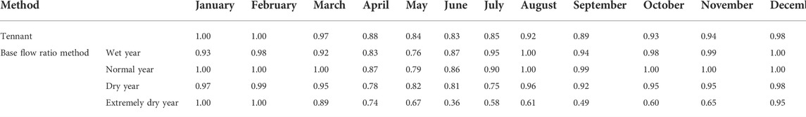
TABLE 5. Guaranteed rate of ecological base flow of each month by base flow ratio method and tennant method.
Judging from the guaranteed rate of ecological base flow from 1960 to 2016 (as shown in Figure 2), the rate was high prior to the year 1980, but has shown a significant downward trend ever since. Especially during the period from 1999 to 2000, when severe drought took place for two consecutive years, the guaranteed rate was rather low, which amounted to merely 30% in 1999, only to improve after 2004 overall. Two factors have led to the low guaranteed rate. First, the annual average flow from 1980 to 2004 was about 20% less than the annual average value of the entire research period. Second, since the reform and opening up, the water demands of Yantai City have surged with the rapid industrial and agricultural development.
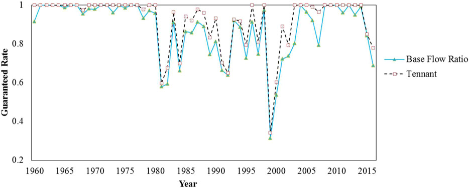
FIGURE 2. Guaranteed rate of ecological base flow over the study period.
There is little difference between the guaranteed rate calculated by the Tennant Method and the Base Flow Ratio Method. Compared with the conventional Tennant Method, the Base Flow Ratio Method can better reflect the variation of ecological base flow in different target years, lead to a better ecological environment, and promote the restoration of local river ecosystem. Therefore, the Base Flow Ratio Method is suitable for areas with uneven intra-annual and inter-annual distribution of water resources (Zhao et al., 2021; Liu et al., 2022).
Conclusion
1) The measured runoff sequence was restored to natural runoff sequence by adopting the item-by-item investigation method. From 1960 to 2016, the annual average value of the natural runoff reduction amounted to 67.52 million m3, justifying the necessity of the runoff restoration sequence.
2) The Tennant Method, the Qp90 Method, the Base Flow Ratio Method, the Wetted Perimeter method, the Texas Method and the Tessman Method were adopted respectively to calculate the ecological base flow of Tuanwang Hydrological Station in Wulong River basin. Our research findings have shown that the Tennant Method, the Base Flow Ratio Method, and the Texas Method are applicable to the calculation of the ecological base flow of Yantai, and in particular, the Base Flow Ratio Method proves to be the optimal approach. The Qp90 Method is more suitable for calculating the ecological base flow during the dry season. In addition, the Base Flow Ratio Method is suitable to calculate the ecological base flow in different target years of Tuanwang Hydrological Station, and the calculation results correspond with the uneven intra-annual and inter-annual distribution of water resources in the study area.
3) Based on the compare of the ecological base flow calculated by the Base Flow Ratio Method with the historical measured runoff sequence, the guaranteed rate of ecological base flow was analyzed for Tuanwang Hydrological Station. In terms of the monthly value, the guaranteed rate of ecological base flow from April to June is low, during which the ecological water demands are prone to contradict with the agricultural water demands. In terms of the period from 1960 to 2016, ever since 1980, the guaranteed rate of ecological base flow has experienced significant declines in the Tuanwang Hydrological Station. This results from the growing water demands for both production and life, which have even led to zero flow of the river. Therefore, it is necessary to properly allocate water resources in the area so as to improve the ecological environment.
Data availability statement
The original contributions presented in the study are included in the article/Supplementary Material, further inquiries can be directed to the corresponding authors.
Author contributions
CG and MH contributed to conception and design of the study. LS, WR, and SS organized the database. YH, YG, and XL performed the statistical analysis. CG wrote the first draft of the manuscript. MH wrote sections of the manuscript. All authors contributed to manuscript revision, read, and approved the submitted version.
Funding
This work was partially funded and supported by the Fundamental Research Funds for the Central Universities (Granted: B220202028), Jiangsu Provincial Water Resources Technology Project (Granted: 2017006).
Conflict of interest
XL was employed by Nanjing Water Group.
The remaining authors declare that the research was conducted in the absence of any commercial or financial relationships that could be construed as a potential conflict of interest.
Publisher’s note
All claims expressed in this article are solely those of the authors and do not necessarily represent those of their affiliated organizations, or those of the publisher, the editors and the reviewers. Any product that may be evaluated in this article, or claim that may be made by its manufacturer, is not guaranteed or endorsed by the publisher.
References
Arthington, A. H., Bunn, S. E., Poff, N. L., and Naiman, R. J. (2006). The challenge of providing environmental flow rules to sustain river ecosystems. Ecol. Appl. 16 (4), 1311–1318. doi:10.1890/1051-0761(2006)016[1311:TCOPEF]2.0.CO;2
Cao, Z. J., Li, X., Tong, C., Dong, J., and Wang, L. M. (2013). Survey on fresh water fishery resources in Shandong Province. J. Agric. 3 (7), 44–51. doi:10.3969/j.issn.1007-7774.2013.07.012
Chacko, S., Kurian, J., Ravichandran, C., Vairavel, S. M., and Kumar, K. (2021). An assessment of water yield ecosystem services in periyar tiger reserve, southern western ghats of India. Geol. Ecol. Landscapes 5 (1), 32–39. doi:10.1080/24749508.2019.1699988
Chen, X., Quan, Q., Zhang, K., and Wei, J. (2021). Spatiotemporal characteristics and attribution of dry/wet conditions in the Weihe River Basin within a typical monsoon transition zone of East Asia over the recent 547 years. Environ. Model. Softw. 143, 105116. doi:10.1016/j.envsoft.2021.105116
Huang, B., Jiang, H., Liao, X. H., and Qian, Z. (2019). Evaluation of ecological water-level in the Dongting Lake with hydrological alterations. China Rural Water Hydropower (3), 88–91+96.
Huang, Q., Li, Q., Zhang, Z. Z., Wang, Y. M., and Li, Y. B. (2007). Improvement Tennant method and application it to compute eco-environmental water requirement in Yellow River. J. Hydrodynamics (6), 774–781. doi:10.3969/j.issn.1000-4874.2007.06.016
Ji, L. N., Liu, S. X., and Wang, X. C. (2010). Wetted perimeter approach to estimate instream flow requirements: A case study in luanhe water system. Prog. Geogr. 29 (3), 287–291. doi:10.11820/dlkxjz.2010.03.005
Karakoyun, Y., Yumurtaci, Z., and Dönmez, A. H. (2016). Environmental flow assessment for energy generation sustainability employing different hydraulic evaluation methods: Çambaşi hydropower plant case study in Turkey. Clean. Technol. Environ. Policy 18 (2), 583–591. doi:10.1007/s10098-015-1023-9
Li, C., and Kang, L. (2014). A new modified Tennant method with spatial-temporal variability. Water Resour. manage. 28 (14), 4911–4926. doi:10.1007/s11269-014-0746-4
Li, X., and Wei, X. (2015). Runoff restoration method based on observability-controllability model of periphery. Water Resour. Hydropower Eng. 46 (1), 11–16.
Lin, S. G. (2017). Application of improved TENNANT model in ecological water demand assessment. Water Resour. Plan. Des. (2), 72–74+124. doi:10.3969/j.issn.1672-2469.2017.02.023
Liu, C. M., Men, B. H., and Song, J. X. (2007). Ecological Hydraulic Radius Model for ecological water demand in rivers. Prog. Nat. Sci. 1, 42–48. doi:10.3321/j.issn:1002-008X.2007.01.007
Liu, S., Liu, Y., Wang, C., and Dang, X. (2022). The distribution characteristics and human health risks of high- fluorine groundwater in coastal plain: A case study in southern laizhou bay, China. Front. Environ. Sci. 10, 901637. doi:10.3389/fenvs.2022.901637
Liu, Y., Zhang, K., Li, Z., Liu, Z., Wang, J., Huang, P., et al. (2020). A hybrid runoff generation modelling framework based on spatial combination of three runoff generation schemes for semi-humid and semi-arid watersheds. J. Hydrology 590, 125440. doi:10.1016/j.jhydrol.2020.125440
Men, B. H., and Liu, C. M. (2008). Modified calculative criterion of Tennant and its application. J. Harbin Inst. Technol. 40 (3), 479–482. doi:10.3321/j.issn:0367-6234.2008.03.033
Neubauer, C. P., Hall, G. B., Lowe, E. F., Robison, C. P., Hupalo, R. B., Keenan, L. W., et al. (2008). Minimum flows and levels method of the St. Johns River water management district, Florida, USA. Environ. Manag. 42 (6), 1101–1114. doi:10.1007/s00267-008-9199-y
Quan, Q., Gao, S., Shang, Y., and Wang, B. (2021). Assessment of the sustainability of Gymnocypris eckloni habitat under river damming in the source region of the Yellow River. Sci. Total Environ. 778, 146312. doi:10.1016/j.scitotenv.2021.146312
Sakke, N., Mapa, M. T., and Saudi, A. (2018). Analysis of several hydrological-drought duration parameters in mengalong River basin, sipitang, sabah. Malays. J. Geosci. 2 (2), 22–25. doi:10.26480/mjg.02.2018.22.25
Singh, S., Kanhaiya, S., Singh, A., and Chaubey, K. (2019). Drainage network characteristics of the ghaghghar River basin (GRB), son valley, India. Geol. Ecol. Landscapes 3 (3), 159–167. doi:10.1080/24749508.2018.1525670
Song, L. L., Lu, G. H., and Liu, L. (2007). Application and improvement of wetted perimeter method. Water Resour. Hydropower Eng. (10), 10–13. doi:10.3969/j.issn.1000-0860.2007.10.003
Tennant, D. L. (2011). Instream flow regimens for fish, wildlife, recreation and related environmental resources. Fisheries 1 (4), 6–10. doi:10.1577/1548-8446(1976)001<0006:IFRFFW>2.0.CO;2
Tharme, R. E. (2003). A global perspective on environmental flow assessment: Emerging trends in the development and application of environmental flow methodologies for rivers. River Res. Appl. 19 (5-6), 397–441. doi:10.1002/rra.736
Wang, Y., Bi, C. X., and Wang, Z. K. (2017). Analysis and guaranteed measures of ecological base flow for rivers in Yantai City. Regul. Huaihe River (8), 26–27. doi:10.3969/j.issn.1001-9243.2017.08.014
Wu, X. J., Li, H. E., Dong, Y., and Lin, Q. C. (2011). Calculation of ecological basic flow of Weihe River based on basic flow ratio method. Trans. CSAE 27 (10), 154–159. doi:10.3969/j.issn.1002-6819.2011.10.027
Yang, F. D., and Zhang, Y. S. (2018). Study on ecological water demand of seasonal rivers in Western China. Water Resour. Plan. Des. (8), 72–74. doi:10.3969/j.issn.1672-2469.2018.08.020
Yang, Y. H., Cao, S. L., Liu, Y., Li, J. Y., and Liu, C. T. (2016). Calculation of ecological base flow in Xiaoqing river based on improved Tennant method. J. Water Resour. Water Eng. 27 (5), 97–101. doi:10.11705/j.issn.1672-643X.2016.05.18
Yu, S. Y., Xu, Z. X., and Wu, W. (2013). Ecological base flow in the Guanzhong reach of the Wei River estimated by using different hydrological methods. J. Beijing Normal Univ. Nat. Sci. 49 (Z1), 175–179.
Zhang, K., Ali, A., Antonarakis, A., Moghaddam, M., Saatchi, S., Tabatabaeenejad, A., et al. (2019). The sensitivity of North American terrestrial carbon fluxes to spatial and temporal variation in soil moisture: An analysis using radar‐derived estimates of root‐zone soil moisture. J. Geophys. Res. Biogeosci. 124 (11), 3208–3231. doi:10.1029/2018JG004589
Zhang, K., Shalehy, M. H., Ezaz, G. T., Chakraborty, A., Mohib, K. M., Liu, L., et al. (2022). An integrated flood risk assessment approach based on coupled hydrological-hydraulic modeling and bottom-up hazard vulnerability analysis. Environ. Model. Softw. 148, 105279. doi:10.1016/j.envsoft.2021.105279
Zhang, O. Y., and Xiong, M. (2017). Calculate methods of ecological base flow based on the measured discharges. Yangtze River 48 (S2), 61–64.
Zhao, X., Xia, H., Pan, L., Song, H., Niu, W., Wang, R., et al. (2021). Drought monitoring over Yellow River basin from 2003–2019 using reconstructed MODIS land surface temperature in google earth engine. Remote Sens. 13 (18), 3748. doi:10.3390/rs13183748
Keywords: ecological base flow, natural runoff reduction, Wulong river, base flow ratio method, guaranteed rate
Citation: Gao C, Hao M, Song L, Rong W, Shao S, Huang Y, Guo Y and Liu X (2022) Comparative study on the calculation methods of ecological base flow in a mountainous river. Front. Environ. Sci. 10:931844. doi: 10.3389/fenvs.2022.931844
Received: 29 April 2022; Accepted: 11 July 2022;
Published: 04 August 2022.
Edited by:
Yuankun Wang, North China Electric Power University, ChinaReviewed by:
Haiming Lu, Nanjing Hydraulic Research Institute, ChinaXudong Zhou, The University of Tokyo, Japan
Copyright © 2022 Gao, Hao, Song, Rong, Shao, Huang, Guo and Liu. This is an open-access article distributed under the terms of the Creative Commons Attribution License (CC BY). The use, distribution or reproduction in other forums is permitted, provided the original author(s) and the copyright owner(s) are credited and that the original publication in this journal is cited, in accordance with accepted academic practice. No use, distribution or reproduction is permitted which does not comply with these terms.
*Correspondence: Cheng Gao, Z2Nob2hhaUAxNjMuY29t; Manqiu Hao, aGFvbWFucWl1QDE2My5jb20=