
95% of researchers rate our articles as excellent or good
Learn more about the work of our research integrity team to safeguard the quality of each article we publish.
Find out more
ORIGINAL RESEARCH article
Front. Environ. Sci. , 26 July 2022
Sec. Freshwater Science
Volume 10 - 2022 | https://doi.org/10.3389/fenvs.2022.927588
This article is part of the Research Topic Hydrological Connectivity and Sustainable Watershed Management in a Changing Environment View all 13 articles
 Dawei Zhang1,2
 Xiaolin Han3
 Qiang Zhong3,4*Shulei Wang5Liuqian Ding1Yuan Liu3Qigang Chen6Fujun Wang3,4
The middle route project (MRP) of the South to North Water Diversion Project is a significant infrastructure and alleviating water scarcity in Northern China. MRP suffered from untraditional siltation problems. Obvious siltation occurred in the regulating reservoir at the end of the channel and some locations with weak hydrodynamic conditions in the channel when the mineral siltation concentration in the flow is very low. To study the characteristics of the siltation and the siltation time period, an IoT based automatic siltation monitoring system using cloud was installed at the outlet of the inverted siphon project on Xiao River. Three years of online monitoring data since 2018 and the siltation samples at five sites for particle size analysis were collected. The monitoring data shows that siltation mainly occurs during March to October, and almost no siltation occurs in winter. The maximum siltation speed can reach 390 mm per day. The particle size of the siltation gradually increases from upstream to downstream, which mainly occurs in the range above 100 m. The organic matter contained in the siltation shows a significant increase from 40.3 to 86.4% at upstream and downstream sampling position, respectively. Monitoring results shows the main body of the siltation in the MRP is not the traditional siltation but the remnants of the algae that proliferate in large numbers. During March to October, the temperature is suitable for the proliferation of algae which attaches to the sediment particles and gradually grows downstream with the flow.
The South-to-North Water Diversion Project (SNWD) is a multi-decade infrastructure mega-project in China. The main purpose of the project is to alleviate the water shortage in the north area of China. According to the plan, the project is divided into three canal systems as shown in Figure 1 (Liu and Zheng, 2002): the eastern route through the course of the Grand Canal; the middle route from the upper reaches of Han River (the biggest tributary of Yangtze River) via the open channel to Beijing and Tianjin; the western route which goes from three tributaries of Yangtze River in Sichuan province to the northwest China. The east and the middle route have been completed and started operation, and the west route is still under planning. The middle route project (MRP) runs from Danjiangkou Reservoir on the Han River to Tuancheng Lake in the summer Palace in Beijing along approximately 1,277 km long open channel. The first phase of the MRP has been completed and started running from 12 December 2014 (Long et al., 2020). By the end of 2021, the MRP supplied a total of 4.41 × 10¹¹ m3 water to the four provinces of Henan, Hebei, Beijing and Tianjin along the project (Agency, 2021a), and it has played a huge role in supporting residential water and environmental improvement in the areas along the route (Long et al., 2020). For example, 70% of the water used by residents in Beijing comes from the water transfer of the MRP at present (Agency, 2021b).
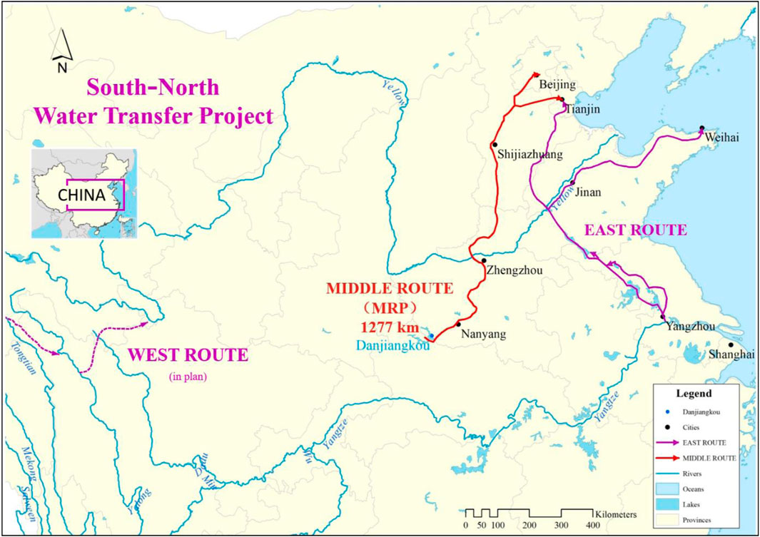
FIGURE 1. The eastern, middle and western route of the South-to-North Water Diversion Project.
After the operation of the MRP, unexpected siltation problem has occurred in areas with weak hydrodynamic conditions. Figure 2 shows the satellite images of Tuancheng Lake in the summer Palace in different years, which is the regulating reservoir between the end of the channel of the MRP and municipal water supply system of Beijing. Before the MRP started running, Tuancheng Lake was clear and there was basically no obvious siltation in 2010 (see Figure 2A). Since the MRP started operation in 2014, more and more siltation has accumulated in the lake as shown in Figures 2B–F.
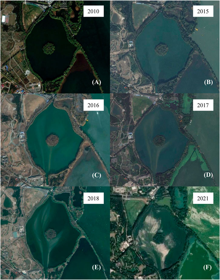
FIGURE 2. Satellite images of Tuancheng Lake from Google Earth over the past 10 years. (A) In 2010. (B) In 2015. (C) In 2016. (D) In 2017. (E) In 2018. (F) In 2021.
Various types of siltation have occurred frequently in the channels, the most common type is in the bends of rivers, where suspended sediment settles due to reduced flow velocity and sediment transport capacity (Nguyen, et al., 2013). Causes of other types of siltation include the influx of tributaries (Pan, et al., 2015; Lee, et al., 2019), rill/interrill erosion or gully/channel erosion (Ben Slimane, et al., 2016) and man-made land reclamation (Obodoefuna, et al., 2020). Siltation in MRP is found to be an unusual siltation problem different from them since there is no source of large amounts of mineral sediment along the channel. Firstly, the MRP introduces the clean water with extremely low siltation concentration (lower than 0.1 kg/m3) from the surface water body in Danjiangkou reservoir (see Figure 1), and the water quality there maintains at an “excellent” level that can be even directly consumed (Nong et al., 2020). Secondly, the MRP is a completely independent channel system of other rivers, thus there is no sediment entering the channel from the rivers along the way. Finally, the region through which the MRP channel passes is not an area where sandstorms frequently occur, and there is no such problem of a large amount of dust entering the channel. Therefore, most of published studies on MRP have focused on the water quality (Li et al., 2011; Tang et al., 2014; Nong et al., 2020), water resource scheduling and distribution (Wei et al., 2010; Zhao et al., 2017; Zhu et al., 2021) and the social and environmental impacts of the project (Long et al., 2020; Zhang et al., 2020; Zhang, 2009), with little attention paid to the problem of siltation.
This unconventional siltation problem has affected the normal operation of the project. The siltation of Tuancheng Lake weakens its regulating and storage function, and siltation of some channels has weakened their water carrying capacity, and the serious siltation before some water release gates brings hidden dangers to the safe and stable operation of the project. At present, the operation department of the project has to use a large number of equipment to continuously dredging in areas with serious siltation.
In order to solve this siltation problem of the MRP, we first need to study temporal and spatial characteristics of siltation and physical properties of siltation. This study developed an Internet of Things (IoT) based automatic siltation monitoring system using cloud and arranged it in the middle reaches of the channel of the MRP to monitor the siltation deposition rate in real time, and 3 years of observational data were collected. The siltation samples at five sites with significant siltation in the MRP were collected for the particle size distribution analysis. The following Methods Section introduces the equipment and data processing methods. Results Section presents the analysis of the data and the results. Finally, a summary is given in Cause of siltation Section.
In order to automatically monitor the siltation in the MRP, this study has developed an IoT based automatic siltation monitoring system using cloud similarly as (Sheng et al., 2020). The whole system is divided into three parts, the data collection device, the data transmission layer, and the data storage terminal on the cloud. The data collection device includes an ultrasonic probe, solar powered equipment and mounting bracket (see Figure 3C). The ultrasonic probe (ultrasonic underwater ranging probe, Anbuleila Ultrasonic Ltd., Figure 3A) measures the distance using the time it takes for the ultrasonic wave to arrive at the probe after it is emitted and reflected on the surface of the siltation. The measurement range of the probe is 0.3–8 m, and the measurement resolution is 5 mm. The solar powered equipment provide power to all other devices. The system can continue working for 5 days under the power of the battery fully charged when the solar panel cannot work (for example the continuous rainy days). The mounting bracket (Figure 3D) fixed the probe in the middle of the channel in front of the water release gate, and ensured that the probe height is fixed and will not shake with the flow.
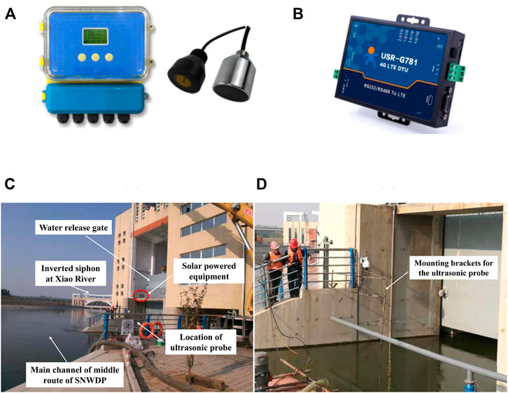
FIGURE 3. Online automatic monitoring system for the siltation in front of the water release gate on the Xiao River: (A) ultrasonic probe; (B) 4G data terminal unit module; (C) installation site of the online automatic monitoring system for siltation; (D) mounting bracket for the ultrasonic probe.
The data transmission layer includes a 4G data terminal unit module (4G DTU USR-G780 V2, USR IOT Technology Ltd., Figure 3B) and the 4G mobile phone signal network. The data storage terminal is a remote cloud platform (USR IOT cloud, USR IOT Technology Ltd.). The ultrasonic probe collects data once per 5 min, and the data is transmitted to the 4G DTU module through a RS485 serial port. Then the 4G DTU module sends the data to the cloud by the 4G mobile phone signal network. We can access the cloud through web access or smart phone client to view and download real-time and historical data. The collected data of distance d from the probe to the siltation surface needs to be converted to the thickness H of the siltation:
where hp is the distance from the probe to the channel bed, which was measured when the probe was mounted. The online monitoring system for siltation was installed in front of the water release gate of the inverted siphon project on Xiao River of the MRP (see Figure 5A), located in Shijiazhuang City in Hebei Province on 31 October 2018.
The original data of the siltation thickness H needs to be post-processed to remove the fluctuations caused by the influence of equipment and the environment noise. There are many fishes in the channel and the ultrasonic probe will report the distance of the fish from the probe rather than the distance between the siltation surface and the probe when the fish swims across the ultrasound transmission route. Hence, there are many sudden values of extreme large siltation thickness as the blue line in Figure 4, and these violent fluctuations should be removed before further analysis. The local standard deviation is used as a threshold to eliminate these noises:
in which N = 25 thus a total of 50 min of data before and after instantaneous i participated in the calculation; σi is the standard deviation of the 50 min data before and after instantaneous i, and μi is the average siltation thickness of the 50 min data. When Hi > μi + σi, the Hi will replace by μi. This process was executed twice, and the violent fluctuations are basically eliminated as shown by the black line in Figure 4. Then, the Fourier transform is performed on the data to filter out high-frequency noise and to obtain the main trend of the siltation. In spectral space, signals with a period less than 7 days are all set to 0, thus in the results the fluctuations with a period less than 7 days are all smoothed as the red line in Figure 4.
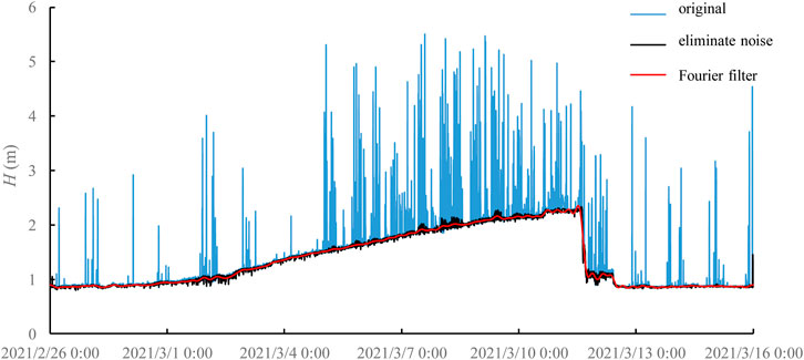
FIGURE 4. Data processing: the blue line is the original measurement data; the black line is the data after removing measurement noise; the red line is the general trend after removing small-scale fluctuations through Fourier filtering.
In September 2019, the siltation samples were collected at five different sites in the MRP, which are the inverted siphon at Qi River in Hebi city (Henan Province), the inverted siphon at Liyang River in Xingtai city (Hebei Province), the inverted siphon at Xiao River in Shijiazhuang city (Hebei Province), the water division at Xihei mountain in Baoding city (Hebei Province), and the outlet sluice at Waihuan River in Tianjin city from upstream to downstream, as shown in Figure 5A. A barrel with a diameter of 8 cm and a height of 20 cm is used for sampling (see Figure 5B and Figure 5C) The collected samples are dried and then the particle size distribution was obtained by the laser diffraction particle size analyzer (Mastersizer 3,000). Then the samples were burned to remove organic matter, and the particle size distribution was obtained again to compare the difference before and after burning.

FIGURE 5. The siltation sampling. (A) the position: 1. the inverted siphon at Qi River in Hebi city, Henan Province; 2. the inverted siphon at Liyang River in Xingtai city, Hebei Province; 3. the inverted siphon at Xiao River in Shijiazhuang city, Hebei Province; 4. the water division at Xihei mountain in Baoding city, Hebei Province; 5. the outlet sluice at Waihuan River in Tianjin. (B) Sampling site photo at the outlet sluice at Waihuan River in Tianjin and (C) the photo of the sample in the sampling barrel.
Figure 6 shows the siltation thickness of continuous observation from 31 October 2018. The meaning of the black and red solid lines in the figure are the same as in the Figure 4. It can be seen from Figure 6 that there was a rapid siltation from October 31 to the early morning of November 6 and the average siltation speed reached 80 mm/day at the measuring point. The siltation at the measuring point has basically stopped from November 6, which may be affected by the dredging operations in front of the gate in the area between the measuring point and the main channel. The dredging operation time is marked by the green color in Figure 6. As a result of the dredging operation at the measuring point, the thickness of the siltation was reduced by approximately 300 mm in a short time starting around 2 p.m. on November 12. Then, the thickness of the siltation at the measuring point showed a slow decreasing trend throughout the winter. The thickness of the siltation changed from approximately 2.54–2.27 m until 6 January 2019, and the decreasing speed of the thickness of the siltation was about 4.3 mm/day. There may be two possible reasons for this reduction. The first one is that the incoming siltation from upstream was reduced during the winter and the siltation in front of the gate was gradually carried downstream by the mainstream. The second possible reason is the siltation was gradually compacted by itself.
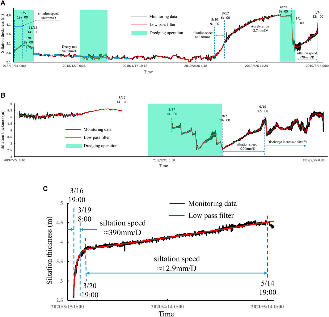
FIGURE 6. Changes in the thickness of the siltation. (A) Changes in the thickness of siltation from 31 October 2018 to 16 May 2019. (B) Changes in the thickness of siltation from 27 July 2019 to 25 September 2019; (C) Changes in the thickness of siltation from 15 March 2020 to 14 May 2019.
During the spring, the thickness of the siltation experienced a rapid increase. From March 10 to 17 March 2019, the increasing speed of the thickness of the siltation reached about 133 mm/day. From March 17 to April 29, the thickness of the siltation still increased rapidly, but the increasing speed gradually decreased, with an average acceleration of the siltation thickness is 2.7 mm/day, and the thickness of the siltation reached 4.66 m on April 29. The decay of siltation velocity may be due to the gradual decrease of the upstream incoming siltation during this period, or may be caused by the movement of the severely silted locations to the main channel after the thickness of the siltation at the measuring point is significantly higher than that of the main channel. The dredging operation at the measuring point on April 29 caused the thickness of the siltation to decrease to 2.9 m. After the dredging, the measuring point immediately entered a state of rapid siltation. The average siltation speed in the early stage reached 70 mm/day. As the siltation thickness gradually increased, the siltation speed gradually decreased again. The thickness of the siltation was up to the maximum value of 5.6 m in the monitoring data on August 15th, and the surface of the siltation is only 0.6 m away from the water surface. After that, due to continuous dredging operations, the thickness of the siltation dropped to 2.5 m on September 10. Throughout spring, summer and autumn, we can see that after dredging operations the thickness of the siltation reduced significantly, followed by a rapid siltation process until the siltation reaches a relatively high height. For example, the siltation speed reached 220 mm/day from September 6 to September 15.
Monitoring data for 2020 and 2021 are similar to 2019. Long-term monitoring results show that the siltation presents obvious seasonality. During the whole winter, there was no obvious siltation, and the thickness of the siltation is slowly decreasing. The period of rapid siltation is from March to October. During the 3-year monitoring period, the maximum and second largest siltation speed occurred during March 16–19, 2020 (Figure 6C) and September 7–15, 2019 (Figure 6B), respectively. The maximum siltation speed reached an astonishing 390 mm per day. This implies that there is a high density of siltation concentration in the mainstream of the MRP channel at the monitoring point in spring, summer and autumn. The siltation speed is related to the thickness of the siltation. If the thickness of the siltation is small, rapid siltation is prone to occur. In contrast, the siltation speed decreases. For example, the siltation speed gradually reduced to 12.9 mm per day after the serious siltation from March 16 to 19 March 2020 (Figure 6C). In addition, hydrodynamic condition can also affect the siltation speed. In order to reduce the flood control pressure of the water source Danjiangkou Reservoir and increase the water supply, the flow discharge at the head of the MRP has gradually increased by 50 m3/s from 12 September 2019 and the total flow discharge at last reached 350 m3/s for the first time. In Figure 6B, it can be seen that with the increase of hydrodynamic conditions, the siltation thickness decreased significantly after September 15, and the average siltation speed decreased after that.
Based on these test results, we can infer that throughout the spring, summer and winter, the flow in the main channel transports a large amount of siltation from upstream to downstream, and rapid siltation will occur in areas where local hydrodynamic conditions are weakened. It should be noted that due to the needs of equipment maintenance, dredging operations and the power outages caused by the continuous rain, the monitoring from May 16 to July 27 and August 17 to August 27 was interrupted, but from the monitoring data in the following years, the basic conclusions are consistent.
The median and average particle size analysis results of the siltation samples collected from different locations are shown in Table 1. From Table 1, it can be seen that the original median and average diameters roughly increase from upstream to downstream. The median and average diameters after burning are significantly smaller than the original ones and there is no significant change in the diameters of the burning samples from upstream to downstream. Since the burning of the sample removes the organic components and only the inorganic material remains, Table 2 analyzed the organic matter in siltation particles based on the median diameters before and after burning. From Table 2 the content of organic matter shows a significant increase from upstream to downstream. For the sample at Qi River which is the most upstream sampling point in this study, the organic ratio of the siltation particles is 40.3%, and the organic ratios at two points, Liyang River and Xiao River in the middle section are close to 70%, and the downstream point Xihei mountain reaches 86.4%. The results shown in Table 1 and Table 2 indicate that the siltation of MRP are composed by the tiny inorganic sand particles and a large amount of organic matter surrounding it. The volume of organic matter accounts for most of the particles, the organic matter content increases significantly from upstream to downstream. At the same time, there is no significant difference among the diameters of inorganic sand particles from upstream to downstream.
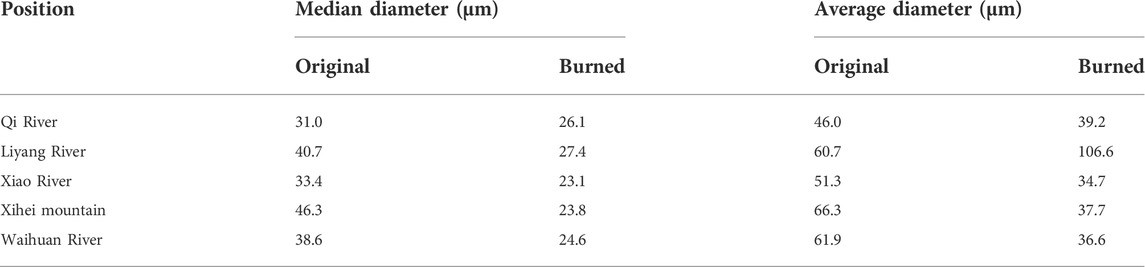
TABLE 1. Analysis of siltation particle size.
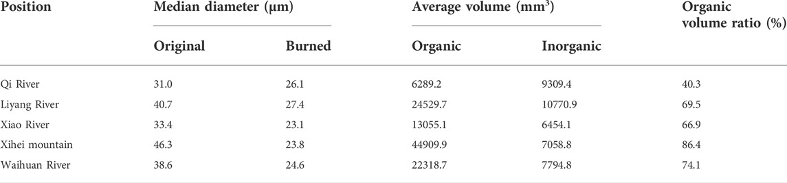
TABLE 2. Analysis of organic matter in siltation particles.
The median and average radius can only show the overall characteristics of the siltation particles. In order to further analyze the particle size composition of siltation particles, Figure 7 shows the particle size distributions from the laser diffraction particle size analyzer. Figure 7A plots the cumulative probability density curves of the diameter of the original samples from different locations. It can be seen that the curves generally move towards the direction of the larger particle size as the locations move from upstream to downstream, which is consistent with the median and average particle size results in Table 1. Figure 7B compares probability density curves of the diameter of the original samples from different locations. The probability density in the small diameter area gathered in 19 and 39 μm two positions, which are around the average particle size after burning as seen in Table 1. On the contrary, the probability density increases in the large diameter area from upstream to downstream. To further determine the cause of the change in particle size, Figure 7C plots the probability density curves of the diameter of the burned samples from different locations. It can be seen that all curves show a much better similarity than the curves in Figure 7B, which means there is no essential change in the size distribution of inorganic siltation particles from upstream to downstream. This indicates that the inorganic siltation in the water body from upstream to downstream should have the same source. Figure 7D compares the particle size distribution of the original and burned samples. Since the results at different locations are similar, only the result at the inverted siphon at Xiao River is plotted in Figure 7D. Unsurprisingly, the original sample curve shifted to the large particle size. It is worth noting that there are also more small particles of about 1 μm in the original sample than that in the burned sample. This may be organic matter shed from intact organic matter.

FIGURE 7. Particle size distribution of siltation samples in the MRP. (A) cumulative probability density curves of the diameter of the original samples; (B) probability density curves of the diameter of the original samples; (C) probability density curves of the diameter of the burned samples (D) cumulative probability density curves of the original and burned samples at Xiao river.
To investigate the cause of siltation, in the previous studies, (Pan, et al., 2015), analysed samples, but did not monitor the changes in siltation in real time. Lee et al. (2019) deployed two ADCPs to monitor the siltation flux at the entrance of a harbour over a month but ADCP is expensive, which is not suitable for long-term monitoring. Whereas, this study combines 3 years of monitoring data and analysis of multiple samples. The results of monitoring and sampling analysis strongly suggest that the main cause of siltation in the MRP is not the traditional siltation but the massively multiplying organisms. Since 2016, the project operators observed that rapid algae growth has occurred in areas of the main canal of MRP in the spring and autumn (Zhu et al., 2019). Then researchers started to focus on risk of water quality deterioration from algae growth (Jing et al., 2021; Nong et al., 2021; Wang et al., 2022). A model prediction results based on the principal component analysis shows that algal density along the canal differs to the greatest extent in summer, followed by spring and autumn, and is the weakest in winter (Jing et al., 2021). Changes in hydrodynamic conditions also affect algal density (Zhu et al., 2019). In addition, (Xu, et al., 2021; Long, et al., 2022), have also mentioned the algae problems in Middle Route of South-to-North Water Diversion Project.
Combined with previous algae study results and current research, the conclusion can be given that the siltation in the MRP is most likely the aquatic algae. In winter, the temperature is too low thus the algae reproduce slowly. Since the concentration of algae in the water body is low, there is basically no siltation. When the ambient temperature raises to a temperature suitable for algae growth during March, algae attach to the inorganic sediment particles in the water and begin to grow rapidly, then the concentration of algae in the water body increases sharply. The maximum siltation speed can reach 390 mm/day at the monitoring points. March to October is the period of vigorous algae blooming, and the concentration of algae residue in the water body maintained at a high level. The algae gradually grow in the process of migrating downstream with the flow. Therefore, the particle size of the original sample of the siltation increases from upstream to downstream.
The water quality from the Danjiangkou reservoir at the channel entrance of the MRP is pretty good and contains almost no siltation. However, during the operation of the MRP, a large amount of obvious siltation occurred in locations with weak hydrodynamic conditions in front of the outlet or the outlet gate. In order to study the time and particle size distribution characteristics of the siltation, an IoT based automatic siltation monitoring system using cloud was developed and installed in the water release gate of the inverted siphon project on Xiao River. Three years’ data are collected since 31 October 2018. The siltation at five sites was also collected for particle size analysis. The main findings are as follows:
1) The siltation mainly occurs from March to October, and almost no siltation occurs in winter. The maximum siltation speed can reach 390 mm per day at the monitoring points. The huge siltation speed indicates there is a high density of siltation concentration in the mainstream of the MRP channel at the monitoring point in spring, summer and autumn. The monitoring data also showed that hydrodynamic condition in the MRP channel can also affects the siltation speed.
2) The particle size of the siltation gradually increases from upstream to downstream, and this growth mainly occurs in the range above 100 μm. The particle size distribution after burning remains basically unchanged from upstream to downstream. The organic matter shows a significant increase from 40.3% at the inverted siphon at Qi River to 86.4% at Xihei mountain downstream.
3) Combining previous research and the results of this study, the main body of the siltation in the MRP is not the traditional siltation but the remnants of the algae that proliferate in large numbers.
The raw data supporting the conclusions of this article will be made available by the authors, without undue reservation.
QZ contributed to design of the study. DZ, SW, and LD finished the field experiments. YL performed the data analysis. XH wrote the first draft of the manuscript. QZ, DZ, and FW wrote sections of the manuscript. All authors contributed to manuscript revision, read, and approved the submitted version.
The study was supported by the National Natural Science Foundation of China (Grant Nos. 52179081, 51809268, 51879138) and the IWHR Research and Development Support Program (WH0145B022021, WH015B042021).
The authors declare that the research was conducted in the absence of any commercial or financial relationships that could be construed as a potential conflict of interest.
All claims expressed in this article are solely those of the authors and do not necessarily represent those of their affiliated organizations, or those of the publisher, the editors and the reviewers. Any product that may be evaluated in this article, or claim that may be made by its manufacturer, is not guaranteed or endorsed by the publisher.
Agency, X. N. (2021a). “The South-to-North Water Diversion Project has provided approximately 49.4 billion water for 140 million people in the past 7 years,” in Construction and administration bureau of South-to-North water diversion middle route project.
Agency, X. N. (2021b). “The South-to-North Water Diversion Project has transferred nearly 50 billion water to the north China in 7 years,” in Website of the central people's government of the people's Republic of China.
Ben Slimane, A., Raclot, D., Evrard, O., Sanaa, M., Lefevre, I. E. N., Le Bissonnais, Y., et al. (2016). Relative contribution of rill/interrill and gully/channel erosion to small reservoir siltation in Mediterranean environments. Land Degrad. Dev. 27 (3), 785–797. doi:10.1002/ldr.2387
Jing, Z., Chen, H., Cao, H., Tang, X., Shang, Y., Liang, Y., et al. (2021). Spatial and temporal characteristics, influencing factors and prediction models of water quality and algae in early stage of Middle Route of South-North Water Diversion Project. Environ. Sci. Pollut. Res. 29, 23520–23544. doi:10.1007/s11356-021-16917-5
Lee, G., Shin, H., Kim, Y. T., Dellapenna, T. M., Kim, K. J., Williams, J., et al. (2019). Field investigation of siltation at a tidal harbor: North port of incheon, korea. Ocean. Dyn. 69 (9), 1101–1120. doi:10.1007/s10236-019-01292-0
Li, S., Li, J., and Zhang, Q. (2011). Water quality assessment in the rivers along the water conveyance system of the Middle Route of the South to North Water Transfer Project (China) using multivariate statistical techniques and receptor modeling. J. Hazard. Mater. 195, 306–317. doi:10.1016/j.jhazmat.2011.08.043
Liu, C., and Zheng, H. (2002). South-to-north water transfer schemes for China. Int. J. Water Resour. Dev. 18 (3), 453–471. doi:10.1080/0790062022000006934
Long, D., Yang, W., Scanlon, B. R., Zhao, J., Liu, D., Burek, P., et al. (2020). South-to-North Water Diversion stabilizing Beijing's groundwater levels. Nat. Commun. 11 (1), 3665. doi:10.1038/s41467-020-17428-6
Long, Y., Feng, M., Li, Y., Qu, J., and Gao, W. (2022). Comprehensive risk assessment of algae and shellfish in the middle route of South-to-North water diversion project.
Nguyen, V., Zheng, J., and Zhang, J. (2013). Mechanism of back siltation in navigation channel in Dinh an Estuary. Vietnam. Water Sci. Eng. 6 (2), 178–188. doi:10.3882/j.issn.1674-2370.2013.02.006
Nong, X., Shao, D., Zhong, H., and Liang, J. (2020). Evaluation of water quality in the South-to-North Water Diversion Project of China using the water quality index (WQI) method. Water Res. 178, 115781. doi:10.1016/j.watres.2020.115781
Nong, X., Shao, D., Shang, Y., and Liang, J. (2021). Analysis of spatio-temporal variation in phytoplankton and its relationship with water quality parameters in the South-to-North Water Diversion Project of China. Environ. Monit. Assess. 193 (9), 593. doi:10.1007/s10661-021-09391-6
Obodoefuna, D. C., Fan, D., Guo, X., and Li, B. (2020). Highly accelerated siltation of abandoned distributary channel in the Yangtze Delta under everchanging social-ecological dynamics. Mar. Geol. 429, 106331. doi:10.1016/j.margeo.2020.106331
Pan, B., Pang, H., Zhang, D., Guan, Q., Wang, L., Li, F., et al. (2015). Sediment grain-size characteristics and its source implication in the Ningxia-Inner Mongolia sections on the upper reaches of the Yellow River. Geomorphology 246, 255–262. doi:10.1016/j.geomorph.2015.06.028
Sheng, Y., Zhang, J., Chen, W., Xie, Y., Sun, G., and Lin, H. (2020). Design of a big data platform for water quality monitoring based on IoT, paper presented at international conference on artificial intelligence and security. Springer.
Tang, C., Yi, Y., Yang, Z., and Cheng, X. (2014). Water pollution risk simulation and prediction in the main canal of the South-to-North Water Transfer Project. J. Hydrology 519, 2111–2120. doi:10.1016/j.jhydrol.2014.10.010
Wang, C., Zhang, H., Lei, P., Xin, X., Zhang, A., Yin, W., et al. (2022). Evidence on the causes of the rising levels of CODMn along the middle route of the South-to-North Diversion Project in China: The role of algal dissolved organic matter. J. Environ. Sci. 113, 281–290. doi:10.1016/j.jes.2021.06.003
Wei, S., Yang, H., Abbaspour, K., Mousavi, J., and Gnauck, A. (2010). Game theory based models to analyze water conflicts in the middle route of the South-to-North water transfer project in China. Water Res. 44 (8), 2499–2516. doi:10.1016/j.watres.2010.01.021
Xu, Y., Liang, J., Lin, J., Lei, X., Ding, G., Yuan, R., et al. (2021). A study on the phytoplankton community structure in the diaohe river section of the middle route of the South-to-North water diversion project in winter. Water Supply 21 (3), 959–970. doi:10.2166/ws.2020.247
Zhang, C., Duan, Q., Yeh, P. J. F., Pan, Y., Gong, H., Gong, W., et al. (2020). The effectiveness of the South‐to‐North water diversion middle route project on water delivery and groundwater recovery in North China plain. Water Resour. Res. 56 (10), e2019WR026759. doi:10.1029/2019wr026759
Zhang, Q. (2009). the South-to-North water transfer project of China: Environmental implications and monitoring strategy. JAWRA J. Am. Water Resour. Assoc. 45 (5), 1238–1247. doi:10.1111/j.1752-1688.2009.00357.x
Zhao, Z.-Y., Zuo, J., and Zillante, G. (2017). Transformation of water resource management: A case study of the South-to-North water diversion project. J. Clean. Prod. 163, 136–145. doi:10.1016/j.jclepro.2015.08.066
Zhu, J., Lei, X., Quan, J., and Yue, X. (2019). Algae growth distribution and key prevention and control positions for the Middle Route of the South-to-North water diversion project. Water 11 (9), 1851. doi:10.3390/w11091851
Keywords: south-to-north water diversion project, water quality, siltation problem, online monitoring, sampling analysis
Citation: Zhang D, Han X, Zhong Q, Wang S, Ding L, Liu Y, Chen Q and Wang F (2022) Online monitoring and sampling analysis of siltation in the middle route of the south-to-north water diversion project. Front. Environ. Sci. 10:927588. doi: 10.3389/fenvs.2022.927588
Received: 24 April 2022; Accepted: 28 June 2022;
Published: 26 July 2022.
Edited by:
Yang Yu, Beijing Forestry University, ChinaCopyright © 2022 Zhang, Han, Zhong, Wang, Ding, Liu, Chen and Wang. This is an open-access article distributed under the terms of the Creative Commons Attribution License (CC BY). The use, distribution or reproduction in other forums is permitted, provided the original author(s) and the copyright owner(s) are credited and that the original publication in this journal is cited, in accordance with accepted academic practice. No use, distribution or reproduction is permitted which does not comply with these terms.
*Correspondence: Qiang Zhong, cXpob25nQGNhdS5lZHUuY24=
Disclaimer: All claims expressed in this article are solely those of the authors and do not necessarily represent those of their affiliated organizations, or those of the publisher, the editors and the reviewers. Any product that may be evaluated in this article or claim that may be made by its manufacturer is not guaranteed or endorsed by the publisher.
Research integrity at Frontiers
Learn more about the work of our research integrity team to safeguard the quality of each article we publish.