 Hongfei Zhang1,2
 Yan Xu
- 1Land Use and Management Center, China Agricultural University, Beijing, China
- 2Inner Mongolia Autonomous Region Natural Resources Protection and Utilization Research Center, Hohhot, China
Land optimization is a necessary means to improve the land use efficiency and promote the sustainable use of land resources. How to fully consider the regional background conditions and scientifically and comprehensively achieve the sustainable and optimal utilization of land resources is a necessary means to promote the sustainable utilization of land resources, especially in semiarid sandy areas with fragile ecological environments. Therefore, based on the characteristics of a semiarid sandy area and by using existing research, with important water resources as the core, this study constructed an optimal land allocation method in a semiarid sandy area based on the soil moisture characteristics. By taking the Horqin Zuoyihou Banner in the semiarid sandy area of China as a typical case, we explored its soil moisture characteristics and influencing factors and put forward the distribution patterns and suggestions for optimal land use. The results show that it is effective to optimize the land space allocation in semiarid sandy areas based on the soil moisture characteristics, and the corresponding land use activities should be arranged according to the moisture conditions of each region, which is beneficial to achieve sustainable semiarid sandy land use. We hope that this study can provide valuable sustainable land optimization solutions for the efficient, sustainable use and protection of land resources in semiarid regions.
1 Introduction
Sustainable land optimization is a necessary means to improve land use efficiency and promote the sustainable use of land resources (Cao et al., 2012; Song and Chen, 2018). However, the effectiveness of land optimization is affected by many factors, including the development levels of social, economic, ecological, and environmental systems (Li et al., 2020; Gao et al., 2021). Therefore, there are many unreasonable land use schemes in land optimization research, which cause our research on land optimization to lack a certain degree of systematic organization and this work cannot propose practical and effective development schemes for decision-makers (Goldstein et al., 2012; Luo et al., 2019). At present, with the rapid development of industrialization and urbanization, land resources are facing the dual tasks of development and protection, dual contradictions between supply and demand, and the dual pressures of resource utilization and ecological protection are present, especially in semiarid areas with fragile ecological environments (Cui and Shi, 2012; Jiang et al., 2020; Deng, 2021). Therefore, how to scientifically achieve sustainable optimal utilization of land is not only an important topic in the land science field but is also a necessary means to improve the land use efficiency and promote the sustainable use of land resources (Cotter et al., 2014; Wang et al., 2021).
China’s arable land resources are insufficient, and the per capita arable land area is less than 0.1 hm2, which is less than 40% of the world (Lai et al., 2020). Cultivated land for the purpose of ensuring food safety and protecting the red line of cultivated land occupies a supplementary balance, and drought and semiarid areas have become an important replenish area for cultivated land in China (Ghabour et al., 2019). It is difficult to develop only without protection, and the use of land use is difficult to sustain; only the reality of protecting and non-development, the reality of the contradiction between human and land, and the growth of grain demand are not allowed (Song and Chen, 2018; Fan et al., 2020a). Meanwhile, groundwater resources are very valuable resources in drought and semiarid areas, which can determine the scope, scale, and form of land protection and utilization, and it is a necessary factor to meet the growth of non-ground vegetation growth in the semiarid area (Liu et al., 2022). Groundwater has a large impact on surface vegetation, and is also a quantitative relationship between groundwater levels, soil water content and plant ecological types (Maihemuti et al., 2021). Therefore, water resources have become an important condition for sustainable optimization and utilization of land resources in dry and semiarid areas (Jiang et al., 2020).
Fortunately, the existing research has conducted a wealth of research on land optimization, which can be roughly divided into three categories. The first group of methods consider the impacts of natural, economic, social and ecological factors on land space utilization from the perspective of the quantitative structure of land use and uses linear programming models, nonlinear programming, dynamic programming and other methods to calculate the allocation of cultivated land use, and an optimal solution for the macroscopic arable land use quantities and structures is obtained (Verhoeye and Wulf, 2002; Li et al., 2020). The second type of method begins with the spatial land use structure, comprehensively considers the natural conditions, quality conditions, spatial forms, and location conditions of the land, and uses multiple optimization models, cellular automata models, genetic algorithms, multiagent particle swarm optimizations, and water footprints to define constraints (such as the total water resources) and optimization goals (such as the maximum economic benefits) in combination with relevant policies to calculate an optimal allocation scheme for land space utilization in terms of the economic, social, and ecological benefits (Liu et al., 2015; Wang et al., 2020; Rahman and Szabó, 2021; Liao et al., 2022). The third type of method predicts the spatial optimization of different land use types, such as cultivated land, forestland, grassland, garden land, and construction land, under multiple future scenarios from the perspective of land use times, which provides a reasonable and effective sustainable development direction for land use in terms of quantitative structures and spatial distributions (Chakir and Gallo, 2013; Qiu et al., 2022; Rong et al., 2022).
The above analysis shows that the existing land optimization plan achieves the unification of land quantitative structures and spatial structure optimization patterns, can effectively coordinate the contradictions among the individual goals of land use and social goals, and has formed the optimization path of “objective function—numerical constraints - space transformation rules - optimization solution”. The research methods and technologies have been improved, which effectively ensure the rational, effective and comprehensive development of the optimal allocation of land space. However, most of the existing research scales are macroscopic, and few scholars have conducted research from the microscopic perspective of the background attribute characteristics of land and have rarely considered the influences of soil moisture characteristics and landform characteristics on the optimal allocation of land, especially in semiarid areas with fragile ecological environments with water shortages and obvious landform differentiation characteristics. Thus, our research on land optimization lacks a certain degree of systematic comprehensiveness and cannot propose practical and effective sustainable land use development measures for decision-makers.
Therefore, to propose a suitable sustainable land optimization scheme for semiarid areas, this study selects the sandy area of the Horqin Zuoyihou Banner, Inner Mongolia Autonomous Region, as the study area. First, we determined the typical year based on the precipitation of the research zone from 1980 to 2019 by using Pearson-III curve. Second, we observe the water dynamics in different soil layers in the soil profile located in the dune depression interphase area in typical years in the study area and clarify the soil water status and its influencing factors in different topographical parts of the growing season by using the time-domain reflectometry method and equidistant layering method. Finally, based on the soil moisture characteristics in the study area, the land use space in the study area is optimally allocated, and corresponding sustainable land optimization suggestions are proposed. We hope that this study can provide valuable sustainable land optimization solutions for the efficient, sustainable use and protection of land resources in semiarid regions.
2 Materials and Methods
2.1 Study Area
The Horqin Zuoyihou Banner is located southeast of Tongliao city, Inner Mongolia Autonomous Region in the central and southern part of the Horqin Sandy Land, between 121°30′-123°42′ E and 42°40′-43°42′N, and the total area is 11,500 km2, which includes 12 towns (Figure 1). The elevations in this region gradually decrease from southwest to northeast, and then to the southeast, most of the sandy meadows are interlaced, the dunes are rolling, and the depressions are distributed vertically and horizontally. The annual average temperature in this region is 5.6°C, the annual average precipitation is 428 mm, which is mainly concentrated from June to August. The annual average sunshine amount is 2,837–2,982 h, and the annual average wind speed is 4.6 m/s (Zhou et al., 2019). The eastern plain is a key grain-producing area, and most of the central and western areas are key animal husbandry areas, which mainly involve planting corn, rice, wheat, and soybeans, with grain outputs sufficient for approximately 2.2 billion heads of cattle and 1.68 million livestock pens (Zhou et al., 2017). In 2020, the regional GDP was 12.3 billion yuan, the registered population reached 395741, and the per capita disposable income reached 19681 yuan (Statistics Bureau of Inner Mongolia Autonomous Region, 2021).
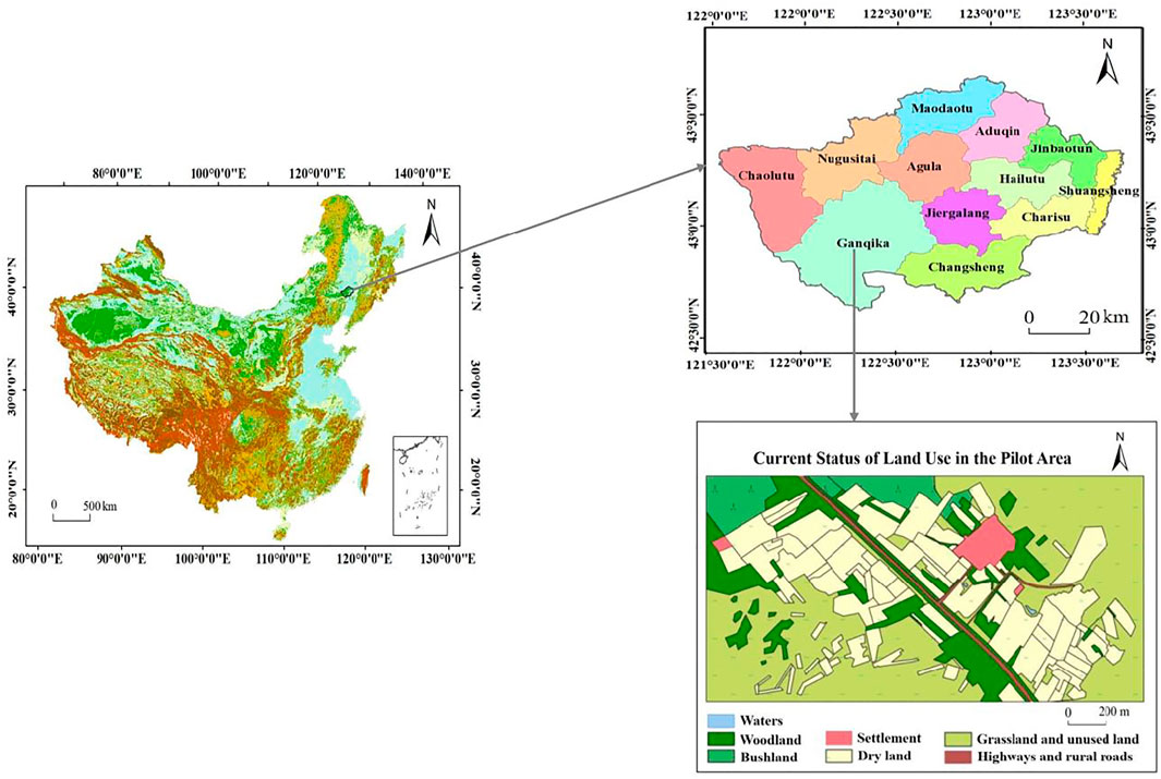
FIGURE 1. Study area location.
Because the Horqin Zuoyihou Banner is located in the hinterland of the Horqin Sandy Land (the largest sandy land in China), which belongs to the transition zone between arid and semiarid zones, the ecological environment is fragile, and the contradiction between water supply and demand is sharp, which is typical and representative, so the Horqin Left Front Banner in Inner Mongolia is selected as a typical case for empirical research (Li et al., 2012; Ge et al., 2015). The experimental area selected was the Wudantala Natural Village in Bulagacha, Ganqika Town, which is located in the central part of Kezuohou Banner, which is a typical dune depression area. The relatively flat land near the settlements has been mostly reclaimed as arable land surrounded by dune depressions. The management level of agricultural land is relatively extensive, and field management by farmers is sparse. The experimental area selected was the Wudantala Natural Village in Bulagacha, Ganqika Town, located in the central part of Kezuohou Banner, which is a typical area with dune depressions. The relatively flat land near the settlements has been reclaimed as arable land surrounded by dune depressions. The management level of agricultural land is relatively extensive, and field management by farmers is sparse. The current land use status in the experimental area is shown in Figure 1C.
2.2 Data Sources
The topographic data in this study are derived from the surveying and mapping data of the land consolidation project in the pilot area, 1:50,000 contour topographic map of the Horqin Zuoyihou Banner, 30-metre-precision DEM data of the Kezuohou Banner, and wetland GPS positioning data, which are combined with UAV aerial photography images. The geological landform and soil hydrology data are obtained from the land consolidation plan of Tongliao city, soil data of the Horqin Zuoyihou Banner, water resource sustainable development and utilization plan of the Kezuohou Banner, hydrological station data from 1980 to 2019, grid sampling data of the experimental area, and sample point profile sampling data. The meteorological data are obtained from the public meteorological data provided by the national stations. In addition, a small, automated weather station is set up in the test area, which automatically records and counts data such as temperature, wind speed, rainfall, and solar radiation at 30-minute intervals. The land use data are obtained from the land remediation plan of the Tongliao Municipal Bureau of Land and Resources and are obtained by visual interpretations combined with remote sensing images and UAV aerial images. The economic and social data are obtained from the 2020 Statistical Yearbook of the Inner Mongolia Bureau of Statistics.
2.3 Research Framework
After reviewing the main literature and theories, we divided the research ideas of this article into the following three parts: 1) This study uses Horqin Zuoyihou Banner as a typical case area for semiarid sand, investigating the precipitation of the area from 1980 to 2019, and using Pearson-III curve to determine the typical year for research. 2) Observations of the characteristics and causes of soil moisture differentiation in the dune depression interphase area: The basic landform of the semiarid area-dune depression interphase area was observed to determine the water dynamics of different soil layers in the soil profile and to understand the soil water statuses and their causes in different topographical areas in the growing season. 3) Propose a sustainable land use optimization model: Based on the above two research results, by referring to previous experience and lessons of land use in the region and combined with the regional economic and social development plan, a regional land use optimization plan based on the principles of conservation and sustainability is proposed. The research framework is shown in Figure 2.
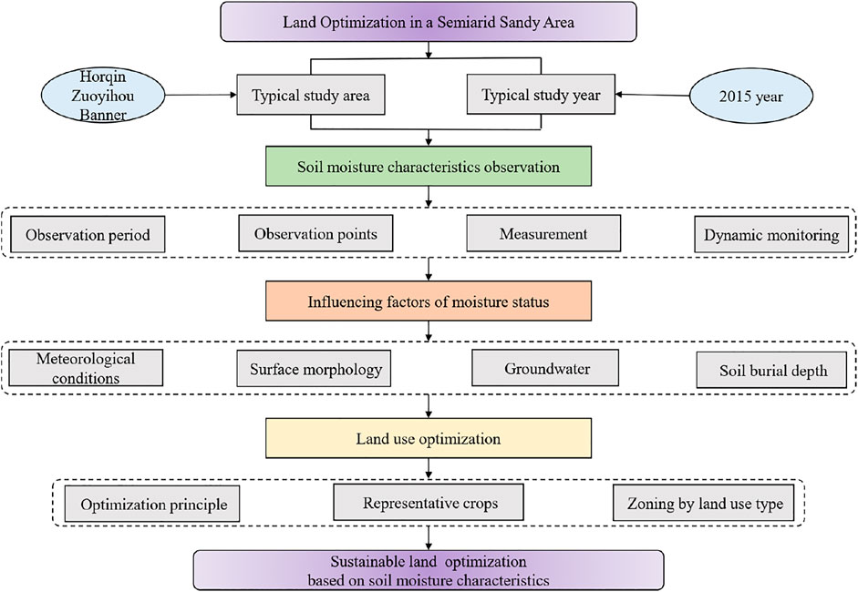
FIGURE 2. Research framework for sustainable research of land optimization in a semiarid sandy area based on soil moisture characteristics.
2.4 Research Methods
2.4.1 Determination of Typical Research Years
Since the precipitation amounts vary greatly among different years, it is necessary to consider the influence of different hydrological years when analysing the supply and demand characteristics of water resources and water consumption for crop irrigation. In this study, the Pearson-III curve was used to analyse the 30-year hydrological years of the Horqin Zuoyihou Banner from 1980 to 2019, and the representative year of the flat-water year (p = 50%) was determined to be 2015 (Ji et al., 1984).
2.4.2 Observation Methods to Determine the Soil Moisture Characteristics
2.4.2.1 Moisture Observation Period
The observation period for this research experiment extended from July 7 to October 21, which is divided into a hot and dry period, high temperature and rainy period, and low temperature and low rain period, which not only considers the typical climate in the region but also maintains continuity in time. At the same time, the arithmetic mean values of the data that are measured by most probes are used as the soil water content values of each section and layer, and the water status trends in areas with differing topography in the project area during this period are then summarized.
2.4.2.2 Layout of Moisture Observation Points
Due to the significant differences in the soil moisture conditions in the parts with differing topography in the dune depression interphase area, the distributions and growth of natural vegetation and crops are significantly different. To explore the crop site conditions in areas with differing topography and to then determine a reasonable design, two observational cross-section transects were selected, which are located on an undeveloped natural dune depression slope and on an adjacent slope that has been developed as a farmland dune depression slope. In addition, we extend from the greatest heights of the dune depressions in the two cross-section belts down to the depressions and select sampling points in different parts as the representatives of various dune depression landforms in the project area to measure the soil properties and monitor the water dynamics. See Table 1 below for a comparison of the sampling points.
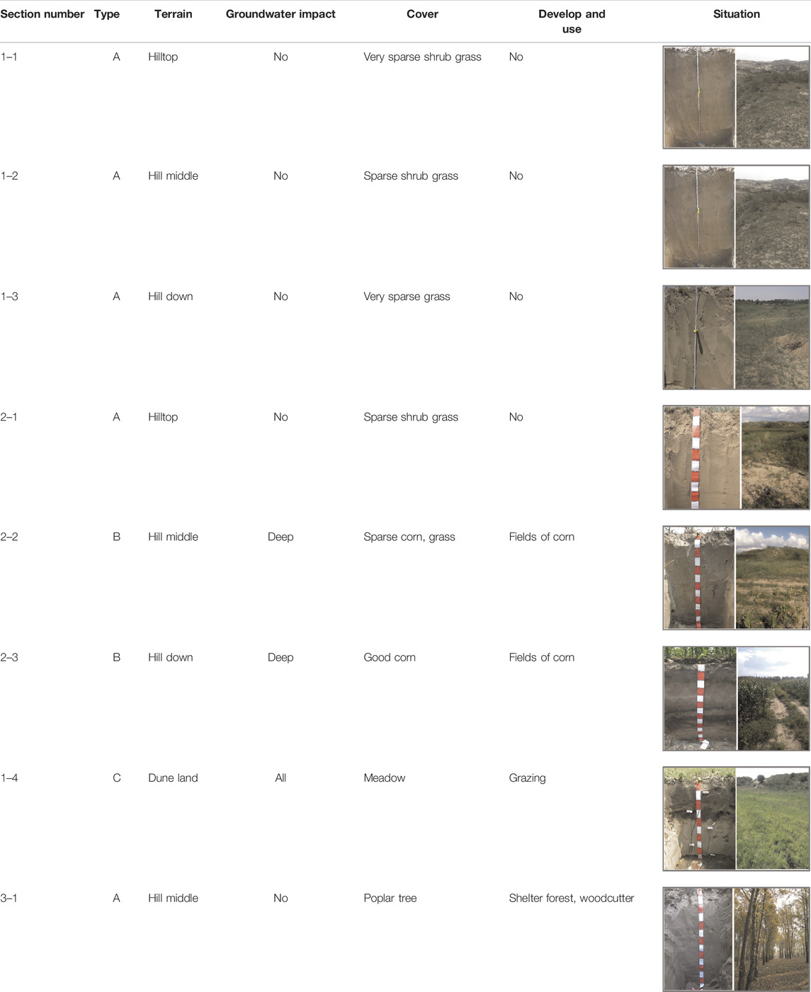
TABLE 1. Summary table of water observation sampling points.
According to the results of the initial measurements when the probe is set, the profile sampling points are roughly divided into three categories: “Type A” (the entire body is dry, profiles 1–1, 1–2, 1–3, 2–1, and 3–1); “Type B” (the deep layer is relatively wet, profiles 2–2 and 2–3); and “Type C” (the entire body is wet, profile 1–4).
2.4.2.3 Soil Moisture Measurement Method
To correctly evaluate the water supply capacity of the land, the soil water contents were measured in this experiment by using the time-domain reflectometry method to understand the dynamic change processes of the soil water contents over a long time period. The TDR100 time domain reflectometer host, manufactured by Campbell Scientific, was selected for the experiment, which can obtain automatic continuous measurements based on Datalogger. A specially customized CS630 three-pin probe sensor is used to act as a wave guide. The probe length is 15.0 cm, the probe diameter is 0.318 cm, and the probe dimensions are 5.75*4.0*1.25 cm. The SDI-12 sensor bus communication protocol is used between the probe and host, and the connection is made with RG-58 coaxial cable and a corresponding standard connector. The water measurement accuracy of the sensor is ±2.5% when measuring dry soils and ±0.6% when measuring saturated soils, which meet the requirements for the measurement accuracy of this experiment. Before burying the probe, the actual probe length is corrected by using the water immersion method to correct the errors that are caused by deformation of the needle. The test adopts a method that involves moving the host computer to obtain point-by-point readings at regular intervals and uses a COM2USB cable to connect a notebook computer with a host computer to form a portable field measurement device. The measurement results are manually read by the PC-TDR program, the waveform diagrams are checked at the same time, and the arithmetic means of the corrected readings of the three waveforms are taken as the results.
2.4.2.4 Dynamic Monitoring Method for Soil Moisture
After selecting the sample points, the section is excavated at each sample point, the equidistant layering method is used to take soil samples at 10, 30, 50, 70, 90, and 110 cm, and TDR probes are embedded to more accurately evaluate the overall conditions along the profile. Dynamic monitoring of the soil moisture in each profile was conducted over a 4-month period, which covered the most important precipitation period and main growing period of crops. The measurements are mainly conducted from approximately 9:00 to 10:00 in the morning, and in the case of rainfall, these are postponed until the next day to obtain a relatively stable moisture distribution trend.
2.4.3 Land Use Space Optimization Method
2.4.3.1 Optimization Principle
The sandy area in the Horqin Zuoyihou Banner is vast and sparsely populated, with low production and operation intensity, and the natural ecology of the region is relatively fragile. Large-scale, high-intensity land development can easily lead to ecological deterioration (Xu et al., 2018). Therefore, it is necessary to avoid damaging the self-regulating function of the ecosystem, protect and restore the ecological environment and fully guarantee the production, living and development needs of local residents. This study plans the land use space based on the four principles of adapting measures to local conditions, setting land with water, minimal disturbance and diversification.
2.4.3.2 Selection of Representative Crops
Based on a literature review and field visits and investigations, this study summarizes the main local land use types, determines the main vegetation types that are involved in each land use type, the habitat habits of crops, and the inputs and outputs of various management methods to analyse the needs and adaptations of each land use to the environmental and socioeconomic conditions (Alados et al., 2011; Fan et al., 2020b). The main representative crops that were selected include corn, rice, alfalfa, Leymus chinensis, Cinnamon japonica, Sadawang, reed, and Caragana.
2.4.3.3 Zoning by Land use Type
Based on the water condition characteristics mentioned above, the land in the experimental area is divided into the following types (Figure 3). The “insufficient flooded areas” with poor moisture conditions consist mainly of those areas with deep groundwater depths (e.g., over 235 m above sea level). “Suitable flooded areas” with better water conditions consist mainly of those areas with slightly higher terrain, such as low-lying land, that is, distributed in areas with high groundwater levels, and the altitudes are between 233 and 235 m. The “excess flooded area” with good water conditions and low-lying terrain is located mainly at the transition stage between seasonal flooded areas and suitable water areas and is not prone to flooding but does not require year-round irrigation. The “seasonal flooded areas” that are prone to water accumulation during the rainy season include wetlands with year-round water, lakes, seasonal wetlands, and seasonal lakes. The terrain mainly consists of depressions and deserts.
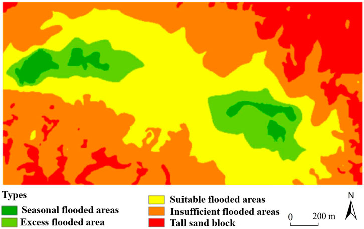
FIGURE 3. Water condition division of the test area.
3 Results
3.1 Analysis of Observation Results of Moisture Status
During the hot, dry period from July to early August, the test area continued to be hot and less rainy, with only a few rainfall events that were less than 10 mm. The water contents of the A, B, and C profiles were 9%–11%, 9%–20%, and 20–45%, respectively (Figure 4A). During the high temperature, rainy period from mid to late August, the rainfall in the experimental area was relatively concentrated, with a cumulative rainfall amount of 195.32 mm. During this period, the soil water contents fluctuated greatly, and the water contents of the A, B, and C profiles were approximately 14%, 15%–40%, and 40%, respectively (Figure 4B). In the period with low temperatures and little rainfall occurring after September, the test area entered autumn, with scarce rainfall and rapid temperature decreases. The measured soil moisture contents fluctuated only slightly, and their standard deviation was less than 1%. The water contents of the A, B, and C profiles were approximately 12%, 13%–30%, and 40%, respectively (Figure 4C).
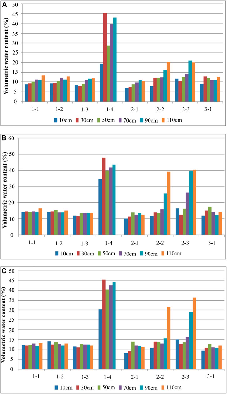
FIGURE 4. Horizontal comparisons of the water content of each section in different periods. (A) is the hot, dry period, (B) is the high temperature, rainy season, and (C) is the low temperature, rainy season.
3.2 Analysis of the Influencing Factors of Moisture Status
Based on the above test results, this study further analysed the influencing factors of soil water contents in the study area under different times and spaces from four aspects, including meteorological conditions, surface morphology, groundwater and soil burial depth. First, in the three stages with hot and dry conditions, high temperature and rainy conditions, and low temperature and little rain with different meteorological conditions, temperature and precipitation have different degrees of influence on the soil water content through water infiltration and water evapotranspiration, respectively. Second, different slope aspects and positive and negative topographies features (e.g., dunes and depressions) affect the soil water content by redistributing solar radiation and surface runoff. Third, groundwater, as a variable with a certain regional consistency, is a direct influencing factor for the water content variations observed in different sections. Finally, the soil in the study area consists mostly of unstructured sandy soil with a uniform top and bottom. The closer it is to the surface, the easier it is for water to evaporate into the atmosphere or be absorbed by the roots of vegetation, which thereby affects the soil water content.
3.3 Land Use Optimization Results Based on Soil Moisture Conditions
Based on the observation results and influencing factors of the above-mentioned soil moisture conditions, this study follows the principle of least disturbance and diversification and uses water to determine the land types associated with different soil moisture contents. According to the actual situation of the pilot area types according to local conditions, a corresponding land space utilization planning scheme is formulated. During the planning process, all existing roads, forestland and residential construction land remain unchanged, as shown in Figure 5A.
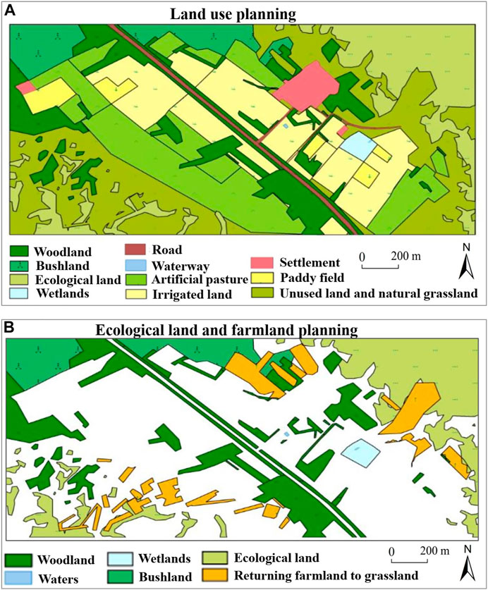
FIGURE 5. Land use planning, ecological land and farmland planning.
The current patches of arable land in the experimental area are relatively messy, and this distribution is not conducive to large-scale operations. Therefore, it is recommended to carry out land consolidation, rezone the plots, and adjust the planting types according to the water conditions during the land consolidation process. Specifically (Figure 5B), for seasonally flooded areas, their areas, shapes and locations should be adjusted accordingly, and appropriate engineering measures should be adopted to reclaim them as paddy fields or reserve them as wetland reserves. The water-excess area is the main area for grain crop production. In drought years, no irrigation is required to grow corn. Intensive management steps should be carried out to increase the yield per unit of crops. The area, that is, suitable for water is large, but in years with less rain, the cooperation of irrigation measures is needed to ensure the corn output. Therefore, those areas that are far from residential areas are defined as artificial pastures, and relatively drought-tolerant alfalfa, Leymus chinensis, and other crops are planted, while the areas closer to the settlements are still used as dry land, and water-saving irrigation measures such as drip irrigation or sprinkler irrigation are used. All of the cultivated land in the water-deficient area should be converted into artificial pastures, and these could also be enclosed for natural recovery if the conditions are suitable. The sporadic unused land in the settlements can be transformed into village greening, but outside of the settlements, if there is no need for transformation, the status quo can be retained. For road land, it is recommended to build ecological roads in the pilot area; that is, instead of building hardened pavements, shrubs with developed lateral roots and drought resistance should be used to stabilize both sides of the road, and the roads should be fixed through the action of root systems to bind the soil herbs.
4 Discussion
4.1 Effectiveness of Land Optimization Methods Based on Soil Moisture Characteristics
As a valuable resource type in arid and semiarid areas, groundwater resources determine the scope, scale and form of land protection and utilization to a certain extent (Mitter and Schmid, 2021). The vast, deep, sandy sedimentary layers of the Horqin Sandy Land have good connectivity, and the water infiltrating from various places gathers underground as a whole; even when there is no rainfall, the low-lying desert can still obtain a sufficient water supply. Therefore, groundwater provides a large reservoir in the Horqin Sandy Land. Groundwater is not only the main water source for natural vegetation and field crops but is also the domestic water source for the rural residents in this region (who live in a large number of scattered villages without centralized water supply conditions). However, due to the severe soil desertification in the Horqin Sandy Land, the water retention capacity is extremely poor, and the leakage of natural precipitation is extremely rapid (Zhao et al., 2018). The groundwater depths in this area are very shallow, and the direct supply of groundwater and indirect recharge of water vapour condensation constitute the main and most stable sources of soil moisture. Therefore, it is reasonable and necessary to optimize the land space allocation in semiarid sandy areas based on the soil moisture characteristics.
4.2 Limitations of Traditional Optimal Land Utilization
Due to the high population pressure, the pursuit of “the best use of the land” in land use, through highly intensive investments in capital, labour, water and fertilizer, to build a large area of high-yield farmland, that is, concentrated and contiguous, the traditional optimal allocation of land is mainly used in the relatively humid plains area. The core elements of this land optimization method are as follows: large-scale flat farmland constructed through land levelling, filling ditches and ravines, and land rezoning; moisture control by means of well-established irrigation and drainage systems; and high-input artificial methods such as fertilizers and pesticides being used to maintain farmland outputs.
In the Horqin Sandy Land, there are many limitations to this method of utilization (Zhu et al., 2020). 1) The Horqin area is vast and sparsely populated, and the contradiction between man and land is relatively lower. What is more important is the quality of the land rather than the quantity. 2) Large-scale land levelling will be a major blow to the already fragile ecological environment and will also lead to the loss of the only nutrients in the topsoil. 3) Since flood irrigation is difficult to carry out, the significance of land levelling is not great. It is only necessary to meet the requirements of mechanized farming by using simple engineering measures. 4) Since the average precipitation amount over many years is only 450 mm and the sand infiltration intensity is high, the water resource pressure from large-scale farming is very high. 5) The capital and labour inputs are relatively high and do not meet the actual local needs. These special natural characteristics mean that large-scale land levelling should not be carried out in this area, which will further aggravate land desertification (Bao et al., 2019; Duan et al., 2019).
4.3 Land Use Optimization Based on Soil Moisture Characteristics
For moisture-deficient areas, due to the harsh conditions, the yields in these areas are low after reclamation and there are even no harvests in drought years, which are the main locations where reclamation-abandonment cycles occur. Therefore, reclamation and planting should be avoided in moisture-deficient areas, and protection should be given priority, or drought-tolerant pastures and shrubs should be planted. For moisture-friendly areas, these areas are usually large, and the deeper layers can be recharged by groundwater, but the water content at the soil surface is slightly lower and the aeration is good. These areas can still support the growth of deep-rooted crops in dry years and will not see decreased crop yields due to stagnant water in wet years.
The suitable water area is the land with the best conditions and is most suitable for agricultural use. It can be used for field farming or for artificial pastures. The excess water area is also the area with low terrain and shallow groundwater depths. In dry years, the region can ensure the water supply of crops, and good harvests can be obtained without irrigation; in rainy years, the groundwater level in the region rises, the soil moisture content is high, the permeability decreases, and deep-rooted crops are susceptible to damage and yield reductions. Therefore, Mesophytes such as corn that are not tolerant to waterlogging can be planted in dry years, and moisture-loving crops such as rice can be planted in normal years and rainy years. The distribution of seasonally flooded areas is random, and these areas have uneven topography. Most of these areas are occupied by reeds because when these areas are not flooded, the groundwater depths are relatively shallow, and the soil water contents are high. After receiving long-term deposition, the soil is relatively fertile, with strong water and fertilizer retention capabilities. By taking advantage of the seasonal flooding in this area, paddy fields can be reclaimed, and rice can be grown.
4.3 Suggestions for Optimal Sustainable Land Use
First, water is the most important limiting factor in the Horqin Sandy Land. By studying the spatial differentiation of the soil moisture conditions and “determining land with water”, the corresponding land use activities are arranged according to the moisture conditions of each region, which are the basis for sustainable land use. Specifically, 1) for clumps with poor water conditions, cycles of random reclamation and abandonment will accelerate the degradation of land in the Horqin area, which requires long-term stable management (such as construction land and rotational pastures) to avoid cultivated land becoming the source of desertification. 2) For wetlands that have year-round water, it is necessary to increase the protection efforts to develop seasonally flooded areas to grow rice and to develop dry land with good water conditions to grow corn and other field crops. 3) In view of the two completely different environments that coexist in the small dune and depression areas, the land use activities should be arranged according to the characteristics of the two environments to reduce the damage to the natural landscape, protect biodiversity, and achieve an environmentally friendly and sustainable environment. 4) Based on the soil moisture conditions, the inputs into land use activities according to local conditions are conducive to long-term stable operation and less disturbance to the environment, which are conducive to ecological restoration and sustainable land use.
Second, under the condition that the total amount of water resources is constant and the ecology cannot be destroyed, the limited water resources can be used in those places with higher efficiency (that is, less water can be used to meet the needs of local residents for survival and development) to decrease the impact on the environment. pressure is necessary (Fraser et al., 2013; Dessu et al., 2019). This study believes that adjusting the industrial structure is an important method to develop the semiarid sandy land. If the industrial structure, that is, dominated by agriculture and animal husbandry is to meet the needs of local residents, it will exceed the carrying capacity of the water resources. Non-agricultural land use has a higher level of economic output per unit of water consumption and can meet the survival and development needs of local residents with less land pressure. At present, the primary industry, namely, agriculture and animal husbandry, accounts for a very high proportion of the industrial structure in the study area. Therefore, decreasing the proportion of agriculture in the local economy, increasing the degree of industrialization, creating more non-agricultural employment opportunities, encouraging non-agricultural employment and urbanization of the agricultural population, and reducing the pressure of agriculture on land are options. development way out.
Finally, in the land use process, care should be taken to protect the groundwater (Mitter and Schmid, 2021). The good connectivity of groundwater bodies will rapidly expand the areas that are affected by pollution, which will cause harm via the absorption of natural vegetation, crops, and domestic water intake. More importantly, groundwater is a vital water source in the Horqin area, and groundwater pollution will lead to serious consequences. Therefore, in agricultural production, water-saving irrigation methods should be used to avoid overexploitation while reducing the use of chemical fertilizers and pesticides to avoid pollution (because pollutants are difficult to completely remove once they enter water bodies). For industrial and mining activities, the pressure on groundwater should also be reduced through the selection of water-saving processes and reuse of reclaimed water, and sewage discharges should be strictly controlled.
5 Conclusion
This study took the sandy area of the Horqin Zuoyihou Banner as the study area, which was combined with the background conditions of the study area, determined the typical years of the study through the Pearson-III curve, observed the soil moisture dynamics, and analysed the influencing factors. Then, we divided the study area into four water characteristic areas and formulated different sustainable land use optimization schemes based on the principle of determining land by water and adapting measures to local conditions. The study found that the C profile has the most water content (45%), and the A profile has the least water content (9%); when the precipitation is relatively concentrated, the soil moisture fluctuation is larger; when the rainfall is less, the soil moisture fluctuation is small. The results show that the topography of the Horqin sandy area has a very high correlation with the spatial differentiation of soil moisture, which will lead to differences in plant community distributions and crop growth conditions in areas with different topographies.
Therefore, this study believes that sustainable land use should be based on the soil moisture conditions, and the corresponding land use activities should be arranged according to the moisture conditions of each region. It is also important to protect wetlands that have water all year round, develop seasonally flooded areas to grow rice, develop dry land with good water conditions to grow corn and other field crops, use water-deficient lands as construction land and rotational pastures, and take measures to enclose tall sand tusks to assist natural recovery. We hope that this research can provide practical sustainable land optimization methods for China and other parts of the world and can provide policy recommendations for the sustainable utilization of the cultivated land resources in arid sandy areas and regional sustainable development.
Data Availability Statement
The original contributions presented in the study are included in the article/supplementary material, further inquiries can be directed to the corresponding author.
Author Contributions
YX designed the research; HZ and ZC wrote the main manuscript text; JC performed the data analysis and made figures and tables; FZ provided conceptualization, investigation and methodology. All authors have reviewed the manuscript and approved it for submission.
Funding
This research was supported by the National Natural Science Foundation of China [grant number 41301614] and the Special Scientific Research of the Ministry of Land and Resources of China- Key Technology and Demonstration based on Protective Development of Sandy Land in Inner Mongolia [grant number 201411009].
Conflict of Interest
The authors declare that the research was conducted in the absence of any commercial or financial relationships that could be construed as a potential conflict of interest.
Publisher’s Note
All claims expressed in this article are solely those of the authors and do not necessarily represent those of their affiliated organizations, or those of the publisher, the editors and the reviewers. Any product that may be evaluated in this article, or claim that may be made by its manufacturer, is not guaranteed or endorsed by the publisher.
Acknowledgments
We are also grateful for the comments and criticisms of the journal’s reviewers and our colleagues.
References
Alados, C. L., Puigdefábregas, J., and Martínez-Fernández, J. (2011). Ecological and Socio-Economical Thresholds of Land and Plant-Community Degradation in Semi-arid Mediterranean Areas of Southeastern Spain. J. Arid Environ. 75 (12), 1368–1376. doi:10.1016/j.jaridenv.2010.12.004
Bao, Y. Z., Duan, L. M., Liu, T. X., Tong, X., Guo, Q., Wang, H. M., et al. (2019). Simulation of Evapotranspiration and its Components for the Mobile Dune Using an Improved Dual-Source Model in Semi-arid Regions. J. Hydrol. 592, 125796. doi:10.1016/j.jhydrol.2020.125796
Cao, K., Huang, B., Wang, S., and Lin, H. (2012). Sustainable Land Use Optimization Using Boundary-Based Fast Genetic Algorithm. Comput. Environ. Urban Syst. 36 (3), 257–269. doi:10.1016/j.compenvurbsys.2011.08.001
Chakir, R., and Le Gallo, J. (2013). Predicting Land Use Allocation in France: A Spatial Panel Data Analysis. Ecol. Econ. 92, 114–125. doi:10.1016/j.ecolecon.2012.04.009
Cotter, M., Berkhoff, K., Gibreel, T., Ghorbani, A., Golbon, R., Nuppenau, E.-A., et al. (2014). Designing a Sustainable Land Use Scenario Based on a Combination of Ecological Assessments and Economic Optimization. Ecol. Indic. 36, 779–787. doi:10.1016/j.ecolind.2013.01.017
Cui, L., and Shi, J. (2012). Urbanization and its Environmental Effects in Shanghai, China. Urban Clim. 2, 1–15. doi:10.1016/j.uclim.2012.10.008
Deng, S. (2021). Exploring the Relationship between New-type Urbanization and Sustainable Urban Land Use: Evidence from Prefecture-Level Cities in China. Sustain. Comput. Inf. Syst. 30, 100446. doi:10.1016/j.suscom.2020.100446
Dessu, S. B., Melesse, A. M., Bhat, M. G., Price, R. M., Seid, A. H., Debebe, S. A., et al. (2019). Development and Application of a Priority Rated Optimization Model (PROM) for Multi-Sector Water Resource Management Systems. Environ. Model. Softw. 113, 84–97. doi:10.1016/j.envsoft.2018.11.014
Duan, H., Wang, T., Xue, X., and Yan, C. (2019). Dynamic Monitoring of Aeolian Desertification Based on Multiple Indicators in Horqin Sandy Land, China. Sci. Total Environ. 650, 2374–2388. doi:10.1016/j.scitotenv.2018.09.374
Fan, J., Wang, L., Qin, J., Zhang, F., and Xu, Y. (2020a). Evaluating Cultivated Land Stability during the Growing Season Based on Precipitation in the Horqin Sandy Land, China. J. Environ. Manag. 276, 111269. doi:10.1016/j.jenvman.2020.111269
Fan, J., Xu, Y., Ge, H., and Yang, W. (2020b). Vegetation Growth Variation in Relation to Topography in Horqin Sandy Land. Ecol. Indic. 113, 106215. doi:10.1016/j.ecolind.2020.106215
Fraser, E. D. G., Simelton, E., Termansen, M., Gosling, S. N., and South, A. (2013). "Vulnerability Hotspots": Integrating Socio-Economic and Hydrological Models to Identify where Cereal Production May Decline in the Future Due to Climate Change Induced Drought. Agric. For. Meteorology 170, 195–205. doi:10.1016/j.agrformet.2012.04.008
Gao, P. P., Li, Y. P., Gong, J. W., and Huang, G. H. (2021). Urban Land-Use Planning under Multi-Uncertainty and Multiobjective Considering Ecosystem Service Value and Economic Benefit - A Case Study of Guangzhou, China. Ecol. Complex. 45, 100886. doi:10.1016/j.ecocom.2020.100886
Ge, X., Li, Y., Luloff, A. E., Dong, K., and Xiao, J. (2015). Effect of Agricultural Economic Growth on Sandy Desertification in Horqin Sandy Land. Ecol. Econ. 119, 53–63. doi:10.1016/j.ecolecon.2015.08.006
Ghabour, T. K., Ali, R. R., Wahba, M. M., El-Naka, E. A., and Selim, S. A. (2019). Spatial Decision Support System for Land Use Management of Newly Reclaimed Areas in Arid Regions. Egypt. J. Remote Sens. Space Sci. 22 (2), 219–225. doi:10.1016/j.ejrs.2018.04.001
Goldstein, J. H., Caldarone, G., Duarte, T. K., Ennaanay, D., Hannahs, N., Mendoza, G., et al. (2012). Integrating Ecosystem-Service Tradeoffs into Land-Use Decisions. Proc. Natl. Acad. Sci. U.S.A. 109 (19), 7565–7570. doi:10.1073/pnas.1201040109
Ji, X. W., Ding, J., Shen, H. W., and Salas, J. D. (1984). Plotting Positions for Pearson Type-III Distribution. J. Hydrol. 74, 1–29.
Jiang, S., Meng, J., and Zhu, L. (2020). Spatial and Temporal Analyses of Potential Land Use Conflict under the Constraints of Water Resources in the Middle Reaches of the Heihe River. Land Use Policy 97, 104773. doi:10.1016/j.landusepol.2020.104773
Lai, Z., Chen, M., and Liu, T. (2020). Changes in and Prospects for Cultivated Land Use since the Reform and Opening up in China. Land Use Policy 97, 104781. doi:10.1016/j.landusepol.2020.104781
Li, H. W., Li, Y. P., Huang, G. H., and Gao, P. P. (2020). Identifying Optimal Land-Use Patterns Using a Copula-Based Interval Stochastic Programming Model for Urban Agglomeration under Uncertainty. Ecol. Eng. 142, 105616. doi:10.1016/j.ecoleng.2019.105616
Li, M., Fu, Q., Singh, V. P., Liu, D., Li, T., and Zhou, Y. (2020). Managing Agricultural Water and Land Resources with Tradeoff between Economic, Environmental, and Social Considerations: A Multi-Objective Non-linear Optimization Model under Uncertainty. Agric. Syst. 178, 102685. doi:10.1016/j.agsy.2019.102685
Li, Y., Awada, T., Zhou, X., Shang, W., Chen, Y., Zuo, X., et al. (2012). Mongolian Pine Plantations Enhance Soil Physico-Chemical Properties and Carbon and Nitrogen Capacities in Semi-arid Degraded Sandy Land in China. Appl. Soil Ecol. 56, 1–9. doi:10.1016/j.apsoil.2012.01.007
Liao, G., He, P., Gao, X., Lin, Z., Huang, C., Zhou, W., et al. (2022). Land Use Optimization of Rural Production-Living-Ecological Space at Different Scales Based on the BP-ANN and CLUE-S Models. Ecol. Indic. 137, 108710. doi:10.1016/j.ecolind.2022.108710
Liu, X., Cai, Z., Xu, Y., Zheng, H., Wang, K., and Zhang, F. (2022). Suitability Evaluation of Cultivated Land Reserved Resources in Arid Areas Based on Regional Water Balance. Water Resour. Manage 36, 1463–1479. doi:10.1007/s11269-022-03093-5
Liu, Y., Tang, W., He, J., Liu, Y., Ai, T., and Liu, D. (2015). A Land-Use Spatial Optimization Model Based on Genetic Optimization and Game Theory. Comput. Environ. Urban Syst. 49, 1–14. doi:10.1016/j.compenvurbsys.2014.09.002
Luo, X., Lu, X., Jin, G., Wan, Q., and Zhou, M. (2019). Optimization of Urban Land-Use Structure in China's Rapidly Developing Regions with Eco-Environmental Constraints. Phys. Chem. Earth, Parts A/B/C 110, 8–13. doi:10.1016/j.pce.2019.03.001
Maihemuti, B., Simayi, Z., Alifujiang, Y., Aishan, T., Abliz, A., and Aierken, G. (2021). Development and Evaluation of the Soil Water Balance Model in an Inland Arid Delta Oasis: Implications for Sustainable Groundwater Resource Management. Glob. Ecol. Conservation 25, e01408. doi:10.1016/j.gecco.2020.e01408
Mitter, H., and Schmid, E. (2021). Informing Groundwater Policies in Semi-arid Agricultural Production Regions under Stochastic Climate Scenario Impacts. Ecol. Econ. 180, 106908. doi:10.1016/j.ecolecon.2020.106908
Qiu, J., Huang, T., and Yu, D. (2022). Evaluation and Optimization of Ecosystem Services under Different Land Use Scenarios in a Semiarid Landscape Mosaic. Ecol. Indic. 135, 108516. doi:10.1016/j.ecolind.2021.108516
Rahman, M. M., and Szabó, G. (2021). Multi-objective Urban Land Use Optimization Using Spatial Data: A Systematic Review. Sustain. Cities Soc. 74, 103214. doi:10.1016/j.scs.2021.103214
Rong, Q., Zeng, J., Su, M., Yue, W., and Cai, Y. (2022). Prediction and Optimization of Regional Land-Use Patterns Considering Nonpoint-Source Pollution Control under Conditions of Uncertainty. J. Environ. Manag. 306, 114432. doi:10.1016/j.jenvman.2022.114432
Song, M., and Chen, D. (2018). A Comparison of Three Heuristic Optimization Algorithms for Solving the Multi-Objective Land Allocation (MOLA) Problem. Ann. GIS 24, 19–31. doi:10.1080/19475683.2018.1424736
Statistics Bureau of Inner Mongolia Autonomous Region (2021). Inner Mongolia Statistical Yearbook. Inner Mongolia: Inner Mongolia Autonomous Region Statistics Press.
Verhoeye, J., and Wulf, R. D. (2002). Land Cover Mapping at Sub-pixel Scales Using Linear Optimization Techniques. Remote. Sens. Environ. 79, 96–104. doi:10.1016/s0034-4257(01)00242-5
Wang, G., Han, Q., and de vries, B. (2021). The Multi-Objective Spatial Optimization of Urban Land Use Based on Low-Carbon City Planning. Ecol. Indic. 125, 107540. doi:10.1016/j.ecolind.2021.107540
Wang, M., Zhu, C., Wang, F., Li, T., and Zhang, X. (2020). Multi-factor of Path Planning Based on an Ant Colony Optimization Algorithm. Ann. GIS 26, 101–112. doi:10.1080/19475683.2020.1755725
Xu, L., Tu, Z., Zhou, Y., and Yu, G. (2018). Profiling Human-Induced Vegetation Change in the Horqin Sandy Land of China Using Time Series Datasets. Sustainability 10, 1068. doi:10.3390/su10041068
Zhao, S., Xia, D., Jin, H., Jia, J., and Liu, B. (2018). A Multi-Proxy Late Holocene Climate Record from Aeolian Deposits of the Horqin Sandy Land, Northeast China and its Societal Implications. Aeolian Res. 35, 29–38. doi:10.1016/j.aeolia.2018.09.004
Zhou, J., Xu, Y., Gao, Y., and Xie, Z. (2019). Land Use Model Research in Agro-Pastoral Ecotone in Northern China: a Case Study of Horqin Left Back Banner. J. Environ. Manag. 237, 139–146. doi:10.1016/j.jenvman.2019.02.046
Zhou, J., Zhang, F., Xu, Y., Gao, Y., and Xie, Z. (2017). Evaluation of Land Reclamation and Implications of Ecological Restoration for Agro-Pastoral Ecotone: Case Study of Horqin Left Back Banner in China. Chin. Geogr. Sci. 27, 772–783. doi:10.1007/s11769-017-0907-5
Keywords: semiarid sandy regions, land resources, soil moisture, land optimization, sustainable land
Citation: Zhang H, Cai Z, Chen J, Xu Y and Zhang F (2022) Sustainable Research of Land Optimization in a Semiarid Sandy Area Based on Soil Moisture Characteristics. Front. Environ. Sci. 10:921345. doi: 10.3389/fenvs.2022.921345
Received: 15 April 2022; Accepted: 05 May 2022;
Published: 06 June 2022.
Edited by:
Jinlong Gao, Nanjing Institute of Geography and Limnology (CAS), ChinaReviewed by:
Zhang Yu, Inner Mongolia University, ChinaHongyan Chen, Shandong Agricultural University, China
Copyright © 2022 Zhang, Cai, Chen, Xu and Zhang. This is an open-access article distributed under the terms of the Creative Commons Attribution License (CC BY). The use, distribution or reproduction in other forums is permitted, provided the original author(s) and the copyright owner(s) are credited and that the original publication in this journal is cited, in accordance with accepted academic practice. No use, distribution or reproduction is permitted which does not comply with these terms.
*Correspondence: Yan Xu, eHlhbkBjYXUuZWR1LmNu