 Guanghui Jiang
 Tianqian Chen
 Ruijuan Zhang
 Yaya Tian
 Siduo Wu
95% of researchers rate our articles as excellent or good
Learn more about the work of our research integrity team to safeguard the quality of each article we publish.
Find out more
ORIGINAL RESEARCH article
Front. Environ. Sci. , 13 May 2022
Sec. Land Use Dynamics
Volume 10 - 2022 | https://doi.org/10.3389/fenvs.2022.902556
This article is part of the Research Topic Towards Greener Urbanization: Resource Environmental Effects and Sustainable Land Use View all 16 articles
Affected by rapid urbanization, the spatial layout of rural residential land (RRL) is facing urgent reconstruction and adjustment. The study of spatial change patterns of RRL can provide a basis for optimization and adjustment. The Pinggu of Beijing was chosen as the study area. Taking into account the layout characteristics of RRL from 2005 to 2015, a combination matrix method was developed to identify the spatial change patterns. The distribution characteristics of the change patterns under different environmental gradients were further analyzed. The study shows that the layout types of RRL in Pinggu in 2015 were dominated by the dispersion-regular-large scale cluster type and concentration-regular-large scale cluster type. The area of RRL patches in Pinggu increased by 686.89 hm2 from 2005 to 2015, which was approximately 12%. The main spatial change patterns of the RRL are the cluster leapfrog dispersion change pattern and cluster edge-expansion concentration change pattern. The distribution of the pattern of RRL shows a decreasing trend under the topography and location gradients set in this paper. And the spatial patterns of RRL are changing at an accelerated rate due to the advanced production environment represented. Our study analyzes the changing pattern of RRL from multiple environmental gradients and provides a basis for the formulation of RRL layout optimization strategies.
Rural residential land (RRL) is a central expression of rural human-land relations (Ottomano Palmisano et al., 2016), referring specifically to land that is primarily used for farmers’ residences or associated with nonagricultural activities. As rural development has become a global issue in recent years, the spiraling downward trend of rural development elements (e.g., farmers’ livelihoods, educational resources, and labor resources) has become a growing concern (Li et al., 2014; Turner et al., 2014; Liao et al., 2019; Tao et al., 2021). In developing countries represented by China, the movement of the population between urban and rural areas and the reorganization of regional socioeconomic development factor allocation have been accelerating (Elshof et al., 2017; Long et al., 2018; Tu et al., 2018). The layout of RRL is also undergoing drastic changes (Hoggart and Paniagua, 2001; Chen et al., 2017; Long et al., 2018). Villages and cities are an organic whole, and both must be sustainable to support each other (Bai et al., 2014). Liu and Li (2017) encourage the use of scientific methods such as big data monitoring and analysis to monitor rural communities and the environment and find solutions to local problems. Compared to the initial top-down strategy of insufficient public participation (Zhang et al., 2019), bottom-up initiatives can act as “social glue” (Elshof and Bailey, 2015; Li et al., 2016). Therefore, it is crucial to identify the changing patterns of RRL from the rural reality to understand the human-land interaction and its systemic effects.
RRL is an open system with an “element-structure-function” (Wu et al., 2016; Tu et al., 2018), and along with rural evolution, rural restructuring, or rural development transformation, and the layout of RRL is undergoing important changes (Wilczak, 2017). RRL in remote and backward areas is gradually declining, while RRL in areas with significant resource endowments is gradually growing, and playing the function of rural centers (Wang et al., 2016). There is a significant life cycle of RRL (Jiang et al., 2006), showing different forms of evolution, such as development, decline, vacancy, and disappearance, and concentration and dispersion are the two basic trends of RRL layout evolution (Xu et al., 2019).
In general, it is difficult to identify rural areas in remote sensing data and analyze their change patterns, especially since the classification of developed land in rural areas is not as accurate as in urban areas (Wickham et al., 2013). Existing studies mostly use image analysis and other auxiliary variables to determine RRL. Conrad et al. (2015) performed multiscale segmentation for the derivation of building contours, followed by random forest classification of spectral and spatial features of objects. Leyk et al. (2014) used auxiliary variables such as topography, road density, and road distance to identify rural development land. The development evolution of RRL layout is characterized by complexity and diversity due to the heterogeneity of regional natural and economic environments (Li et al., 2018; Qu et al., 2018). Therefore, it is necessary to analyze the layout of RRL as a premise to further identify RRL change patterns.
The evolution of RRL is a product of the evolving human-land relationship, which is a combination of spontaneous generative forces within the RRL system and external environmental context factors such as natural and socioeconomic factors (Zhang, 1998). Factors such as rural exodus, increasing rural unemployment, and the establishment of new development relationships between rural and urban areas are important factors in the evolution of RRL, showing both development and decline (Rey and Bachvarov, 1998; Paquette and Domon, 2001). The study of human-land interaction in rural areas and its systemic effects can create favorable conditions for achieving leapfrog development in rural areas (Newburn and Berck, 2011). Li et al. (2019) analyzes the evolution and transformation mechanisms of the spatial structure of RRLs from the perspective of long-term economic and social changes. Ge et al. (2019) construct a conceptual model of coupling farmland transformation and rural transformation development to propose corresponding land use policies based on the coupling relationship. Existing studies focus on the study of RRLs under a certain environmental factor or human-land relationship or mostly embody a combination of environmental factors (Ito et al., 2016; Hirons et al., 2018; Silva et al., 2019; Tebboth et al., 2019), lack a dynamic and comprehensive study of their change elements combined at multiple scales, and present an overall lack of comprehensive consideration of the natural and socioeconomic environment.
To fill this gap, we adopt a new method for identifying RRL change patterns and reveal the role of environmental background elements on the heterogeneous pattern of spatial change of RRL layout to clarify the mechanism of RRL spatial evolution. To study the change pattern of RRL is actually to obtain a black box composed of human-land interaction. The aim is not to identify specific mechanisms. Rather, it derives rules from it, such as managing the RRL and its environment to guide the development of the RRL. Specifically, the following aspects of work will be carried out: 1) analyze the RRL layout characteristics and RRL patch change processes in the village domain based on the RRL data of Pinggu, Beijing, China, in 2005 and 2015; 2) analyze the connotation and key characterization elements of the RRL layout and identify the RRL spatial change patterns; and 3) analyze the distribution pattern of RRL change patterns under the environmental gradients of topography, location, production conditions, public service, economy, and policy. The study provides a new method for the identification of RRL change patterns and integrates the natural and socioeconomic environments to enhance the understanding of human-land interaction and its systemic effects and provides support for RRL spatial optimization strategies, which can promote sustainable rural development.
Pinggu (40°02′–40°22′N, 116°55′21″–117°24′07″E) is a district 70 km east of Beijing, China (Figure 1). It is in the warm temperate monsoon climate zone, with the terrain sloping from northeast to southwest, forming three types of landforms: mountainous, semi mountainous and plain. The plain area is 34,500 hm2, accounting for approximately 1/3 of the total area. The semi mountainous and mountainous areas account for approximately 2/3 of the total area. The total land use area is 95,000 hm2, and the proportions of farmland, construction land, and other land areas are 80.15, 11.59, and 8.26%, respectively. Among them, the construction land is mainly RRL land, accounting for nearly 50%, and the scale of land use per capita is much larger than 150 m2 (the high limit of construction land area per capita stipulated by the Chinese government). The phenomenon of low-utility land, such as “small houses and large yards” and “hollow villages”, is more common. Therefore, the degree of intensive land use needs to be further improved. At the same time, due to the variability of the regional natural environment, resource endowment, and socioeconomic development, the regional RRL presents a variety of layout types (Zhang et al., 2015). The socioeconomic development of Pinggu is in a stage of rapid development, with a regional economic gross product of 19.7 billion yuan in 2015, maintaining a 7% rate of growth. The account of three industrial structures accounted is 9.5, 46.0, and 44.5%. The industrial structure was continuously optimized. The per capita disposable income level for urban and rural residents in that year was 35,000 yuan and 20,000 yuan, respectively, with the steady growth of urban and rural residents’ income and continuous improvement of consumption ability and quality of life.
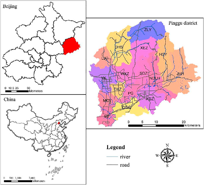
FIGURE 1. Location of Pinggu, Beijing, China (PG is Pinggu Town, the central town of Pinggu District, which is not the research object of this paper).
Land use change research requires a comparative analysis of the change process of specific land use types over a long time series, so the RRL study involves a comparative analysis of data information from different years. The study considers the availability of data, as well as the possible significant impact of regional socio-economic development stages and China’s rural development policies on RRL changes. this study identifies 2005 and 2015 as the time node. In 2005, the Fifth Plenum of the 16th Central Committee of the Communist Party of China proposed comprehensive construction of a new socialist countryside. The data required for this study mainly include the following four types, including remote sensing image, basic geographic data, socioeconomic data, and village research data. Remote sensing image and DEM belong to grid format data with spatial resolution of 30 × 30 m and 10 × 10 m respectively. Other specific data information is shown in Table 1.
TABLE 1. Explanation of the research data type and source.
RRL layout characteristics are an explicit spatial representation, which is the projection of inherent implicit RRL needs in space. RRL bureau spatial change patterns can be understood as a high abstraction and generalization of layout characteristic change information, reflecting the common features and regional differences of the layout change process. Most of the existing studies on RRL layout features and patterns focus only on the descriptive analysis of planar patterns (Yang et al., 2015), lacking in-depth analysis of the static distribution characteristics and dynamic change characteristics of RRLs. Therefore, our study identifies the change patterns of RRL based on the layout characteristics and patch changes of RRL (Figure 2).
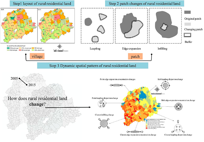
FIGURE 2. Combination matrix method of the dynamic spatial pattern of rural residential land.
This combination matrix method is divided into three steps: 1) identify the types of RRL layout; 2) determine the Spatial change process of RRL patches; 3) combine the results of the first two steps to determine the change pattern. It should be noted that the first step is based on the village, and the second step is based on the RRL patch. According to the barrel principle, the final result should be in units of RRL patches with smaller spatial resolution. In other words, the 2015 layout and 2005–2015 patch changes of a certain RRL can be obtained directly through the change mode name.
Our study uses villages in Pinggu as the study unit and uses the degree of aggregation and dispersion index, the size characteristic index, and the shape characteristic index to describe the layout characteristics of three dimensions, such as distribution, shape, and size Eqs 1–3, and classifies the RRL layout types according to the layout characteristics (Figure 3). Among them, the natural breakpoint method is used to determine two possible states of each feature, such as whether the distribution feature of each village belongs to the concentration or dispersion based on the size of the WAC.
where
where
where SI is the scale feature index;
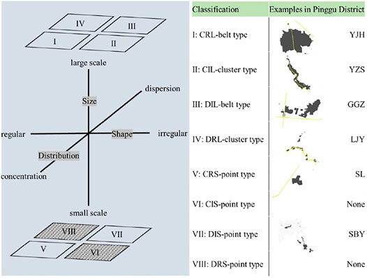
FIGURE 3. Identification method and layout classification of rural residential land.
The way in which the urban landscape is expanding can be judged by using the landscape expansion index (Liu et al., 2009). This method is also adapted to the determination of the change process of RRL. The change methods include infilling, edge-expansion, and leapfrog, which are expressed as three topological relationships: inclusion, intersection, and disconnection relationships (Figure 4). Based on the formation principle of the landscape sprawl index, a buffer zone of a certain distance is generated with the changing RRL patches as the center. The buffer zone is spatially overlaid with the original patches to determine the spatial topological relationship between the changing patches and the original patches (Eq. 4). Considering that most of the RRL are roughly flattened and have high privacy settings, the study uses the psychological distance as the criterion to determine whether the RRL patches are separated from each other and sets the buffer zone radius at 50 m.
where
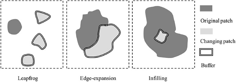
FIGURE 4. Diagram of RRL patch change process (where “RCI" = 0 means the change patch is separated from the original site, which is leapfrog; “0 < RCI≤50″ means the change patch is edge-adjacent to the original site patch, which is edge-expansion; “50 < RCI≤100″ means the change patch is in the original site patch, which is infilling).
RRL is the result of human-land interaction, and the environmental factors affecting its distribution are diverse, mainly from the natural environment, production environment, and socioeconomic, and cultural environment (Sevenant and Antrop, 2007; Wang and Zhang, 2021). The natural environment is the basis for the formation and development of RRL, and topography and rivers are the dominant factors among the natural environmental factors (Tian et al., 2012). The production environment is an artificial environmental system created through conscious social labor, and the production environment that affects the spatial layout of RRL is mainly the agricultural environment (Sevenant and Antrop, 2007), such as the cultivation radius and the richness of surrounding agricultural land (Qiao et al., 2013). Socioeconomic environmental factors give priority to the influence of transportation conditions. As an important transportation corridor in rural areas, the accessibility of roads is a bottleneck limiting the spatial development of rural areas, and the distribution of RRL shows obvious characteristics along roads (Zou and Wang, 2015). Distance from towns is another key factor influencing the land layout of RRL (Liu et al., 2019). In addition, deep-seated sociocultural factors such as neighborhood relations, farmers’ ideology, and clan power are also involved (Lotfi and Koohsari, 2009; Beilin et al., 2014; Zachrisson et al., 2021).
Each influencing factor is not isolated from each other but interconnected to influence the land use pattern of RRL (Wang and Zhang, 2021). Considering various environmental factors, five environmental types were selected, such as topography, location, production conditions, public service, and economy and policy (Table 2). The spatial change patterns of the RRL layout under different environmental gradients were analyzed. Specifically, the spatial overlay analysis method was used to spatially overlay the RRL spatial data and the environmental background factor data in the two periods of 2005 and 2015, and then the results of the factor grading were used to count the percentage of the number of RRLs with different spatial change patterns. The grading criteria of each environmental factor was developed based on the actual results of the study area using a combination of the natural intermittent point method and expert consultation method.
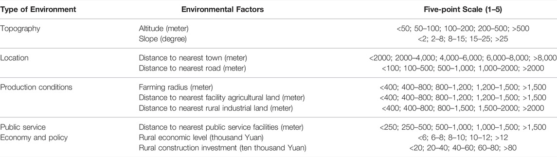
TABLE 2. Grading criteria for major environmental factors.
The RRL in Pinggu was classified into six layout types in 2005 and 2015, which consisted of 275 villages (Table 3 and Figure 5). The spatial distribution and quantitative characteristics of RRL layout types have some similarities. First, the distribution characteristics are relatively consistent, with DRL-cluster type and CRL-cluster type villages mainly distributed in plain areas. The layout types of RRLs in mountainous and semi mountainous areas are mostly dominated by CRS-point type, CIL-belt type, DIS-point type, and DIL-belt type. This is because in areas where the terrain is suitable for living, the agricultural infrastructure is often superior, which is conducive to the concentration of population and the formation of large-scale group-like and cluster-like RRL. This also reflects the impact of topographic and geomorphological conditions on the formation of RRL layout types.
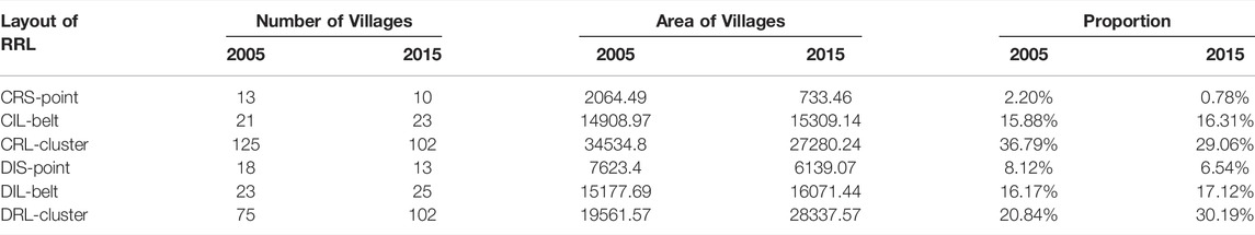
TABLE 3. The number and area of pattern types of rural residential land in Pinggu from 2005 to 2015.
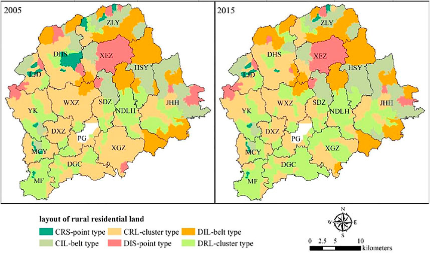
FIGURE 5. Spatial distribution of pattern types of rural residential land in Pinggu.
The differences in the number and scale of RRL layout types in the Pinggu between 2005 and 2015 are also obvious. The layout of RRL in 2005 had the highest proportion and size of the number of CRL clusters (36.79%; 34534.80 hm2), followed by DRL clusters (30.19%; 28337.57 hm2). From 2005 to 2015, the number and scale of villages in the layout of the CRL cluster type decreased most obviously. The number and size of villages in the layout of the DRL cluster type increased significantly.
The specific characteristics of the layout of RRL can be further identified by the different change modes of patches and their combinations, including the total area, number, average patch area, and scale growth contribution of patches with different change modes (Table 4). Overall, the RRL scale in the Pinggu increased by 686.89 hm2 from 2005 to 2015, accounting for approximately 12% of the increase. Among them, the scale growth contribution of edge expansion (59.2%) and leapfrog (39.25%) patches are the main types of site patch changes. There were regional differences in the change process of RRL patches influenced by the heterogeneity of regional environmental conditions (Figure 6).
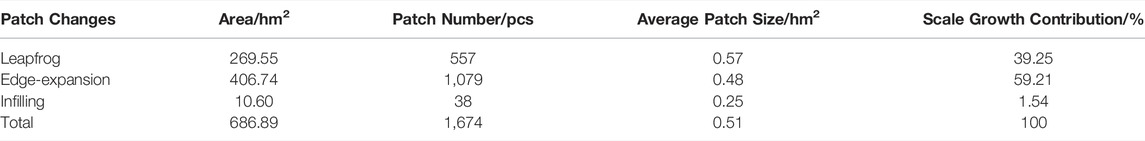
TABLE 4. Areas and numbers of different changing RRL patches in Pinggu from 2005 to 2015.
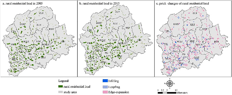
FIGURE 6. Dynamic modes of rural residential land in Pinggu 2005–2015. the spatial distribution of rural residential land patches and its change processes in Pinggu [(A) and (B) are the spatial distribution of rural residential land patches in 2005 and 2015; (C) is the spatial distribution of the three processes of change in rural residential land patches from 2005 to 2015].
The edge-expansion patches mostly rely on the original spatial base for expansion. The leapfrog patches have a good development base and potential, such as topography, natural resources, and location (in the hinterland of the central city). Leapfrog patches generate new scattered patches around the original RRLs, and this evolution will intensify the decentralized development of the RRL layout. Leapfrog patches are relatively scattered, and the number of distributions is relatively high in the periphery of the central city, which is an important urban function. In contrast, the infilling patches are relatively fragmented. Infilling patches rarely appear in the layout evolution of RRL, and this inward intensive development approach contributes to the clustering development of village layouts. The main location is close to the central urban area, the development of RRL is subject to the requirement of intensification to reduce arbitrariness and disorder, and the requirement of intensification of r RRL layout is significantly enhanced.
Based on the characteristics of clustering and dispersion evolution of the layout of RRL in the Pinggu, the spatial change pattern of the layout of RRL in the Pinggu is determined by the combination matrix method, which mainly shows the spatial clustering change pattern and the spatial dispersion change pattern (Figures 7, 8), including point leapfrog dispersion change, point edge-expansion concentration changes, belt leapfrog dispersion change, belt edge-expansion concentration change, cluster leapfrog dispersion change, cluster leapfrog concentration change, and cluster leapfrog dispersion change, point edge-expansion concentration changes, belt leapfrog dispersion change, belt edge-expansion concentration change, cluster leapfrog dispersion change, cluster edge-expansion concentration change, cluster infilling change, are seven other modes of change.
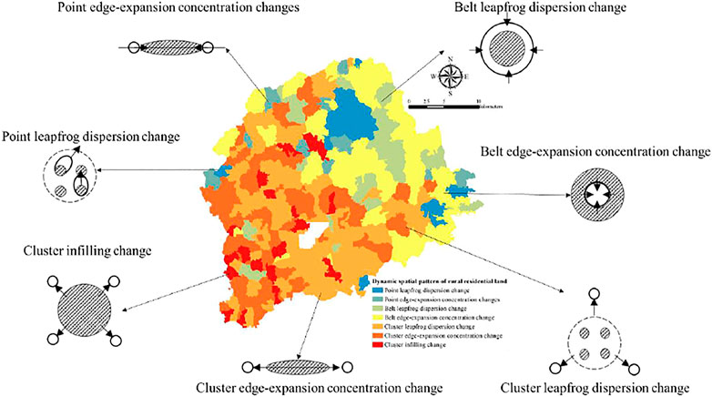
FIGURE 7. Distribution of dynamic spatial patterns of RRL in Pinggu.
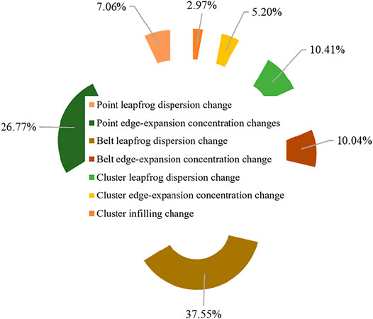
FIGURE 8. Proportion of dynamic spatial patterns of RRL in Pinggu.
The point edge-expansion concentration change pattern is scattered in mountainous and hilly areas, with a large number of land patches and small scale, but there are significant dominant patches. The trend of clustering change is to expand from the center to the edge. Belt edge-expansion concentration change is distributed in mountainous hilly areas, the boundary expansion is constrained by the topography, and the land is continuously extended along the ditches and roads in a linear pattern, resulting in dispersion change. Point leapfrog dispersion change is distributed in mountainous hilly areas in the form of beads, with the road as the axis of a jump-type dispersion change. Cluster infilling change is located near the center of the city, the number of patches is small, the scale is large, and the internal space is used to develop inwardly, resulting in a clustering change in layout. Cluster leapfrog dispersion change mode is located in the plain area, with better location conditions, driven by industrial transformation and spatial renewal, the land use type mainly of industrial enterprises and new communities show jumping dispersion change.
The degree of concentration of the RRL shows an obvious vertically decreasing law as the elevation and slope gradually increase (Figure 9). The high-altitude environment determines the prominent characteristics of small and scattered RRL. But due to the strong constraints on its spatial development, the evolution of RRL layouts instead shows concentration development. The number of RRLs with different spatial change patterns on each slope gradient shows that the change pattern of RRL below the 2° slope is dominated by the cluster leapfrog dispersion change pattern and cluster edge-expansion concentration change pattern. The slope size often determines the advantages and disadvantages of agricultural infrastructure, and gentle terrain conditions are conducive to the clustering of large-scale RRLs, while the slope advantage reduces the construction cost of outward development of RRLs, and the outward rough development of RRL is higher, often forming new residential clusters.
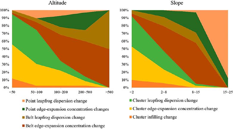
FIGURE 9. Distribution characteristics of the dynamic spatial pattern of RRL under the topography gradient.
The factors selected for the location environment gradient include town proximity and road accessibility (Figure 10). In the area less than 2000 m away from the town center, the main change pattern is cluster leapfrog dispersion change and cluster edge-expansion concentration change. The area is closer to the town, whose spatial development is restricted by the influence of town spatial development and industrial park construction, especially the increased requirement of intensification of RRL. With the gradual increase of the distance from the town, the spatial expansion of RRLs decreases significantly, which to a certain extent foreshadows the potential declining trend of rural spatial development in areas where the influence of town radiation is weak.
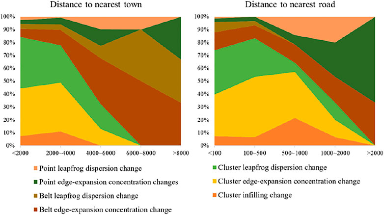
FIGURE 10. Distribution characteristics of the dynamic spatial pattern of RRL under the location gradient.
The RRL spatial changing pattern is greatly influenced by roads. The RRL near the road still shows a certain spatial accessibility dependence, and the new sites are mostly extended along the road axis on the basis of the original space. As the distance between the RRL and the road gradually increases, the spatial expansion scale of RRL shows a gradual decline. In the range of fewer than 100 m and 100–500 m from the road, the change patches mainly show the characteristics of edge expansion. With a distance of more than 500 m from the road, the RRL changing pattern shows the characteristic of mainly leapfrog. The new sites tend to expand in the direction of the road, which further leads to a more dispersed layout pattern of RRL.
The RRL is the main settlement place for the population engaged in agricultural production work, so three factors, farming radius, distance to the facility agricultural land, and distance to the rural industrial land, were selected to construct the production environment gradient. From the comparison of changing pattern in 2005 and 2015, the RRL shows a dispersion trend, with the increased distance to the facility agricultural land or the rural industrial land. In the farming radius gradient, the trend is the opposite (Figure 11). There is a strong spatial convergence between the concentration of arable land and the clustering of RRLs, and the clustering of RRL layout decreases as the concentration of arable land decreases. The degree of decentralization of the RRL layout evolves and weakens with the decrease in the concentration of farmland. In areas with concentrated arable land distribution, the decentralization of RRL layout evolves to a stronger extent, and the proportion of new RRL patches expanding through leapfrogging is higher.
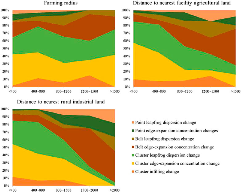
FIGURE 11. Distribution characteristics of the dynamic spatial pattern of RRL under the production condition gradient.
The range of 400–800 m from the agricultural land of facilities is the area with the largest number of RRL, the RRL layout is dominated by a cluster leapfrog dispersion change pattern and cluster edge-expansion concentration change pattern. The RRL layout is dominated by a cluster leapfrog dispersion change pattern and a cluster edge-expansion concentration change pattern. The cluster change pattern has a good development base of RRLs in general, and the high spatial proximity to rural enterprises makes the layout change very active and easily produces new clusters around rural enterprises. New clusters are easily created around rural enterprises, which in turn leads to the formation of clusters of RRLs. The linear and dotted RRLs attract scattered villages to relocate by virtue of the good location of rural enterprises and the employment and income opportunities they provide, further contributing to the development of marginal spatial clustering of linear and dotted RRLs.
With the deepening of the social division of labor and the diversification of rural residents’ living needs, the supply of public services has become a key element affecting the choice of residence, so the role of the accessibility of RRLs to living service facilities led by educational facilities, medical facilities and commercial facilities on the spatial change pattern of RRL layout is considered (Figure 12).
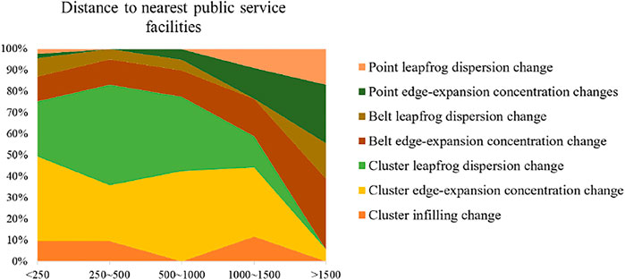
FIGURE 12. Distribution characteristics of the dynamic spatial pattern of RRL under the public service gradient.
The number of RRLs with different spatial change patterns in each distance class of living service facilities shows that the RRL layout change pattern within 1,000 m distance from living service facilities is dominated by the cluster leapfrog dispersion change pattern and the cluster edge-expansion concentration change pattern, while the point leapfrog dispersion change pattern and the belt leapfrog dispersion change pattern dominate the change in the layout of RRLs within 1,000 m distance from the amenities. The variability was dominated by the point leapfrog dispersion change pattern and the belt leapfrog dispersion change pattern. The reason for this variability may be that the configuration of living service facilities usually takes into account the scale of population served and operational efficiency and is often relatively well developed in town centers and urban areas with relatively high population sizes.
This study expressed the rural economic level and rural construction implementation intensity by rural per capita income and rural construction capital investment level, respectively. The level of capital investment and the degree of RRL layout clustering show roughly the opposite relationship. With the increasing per capita income level of villages, the stronger the demand for improving living space, the greater the possibility of changing the land use of RRLs from concentration to dispersion (Figure 13). At the same time, with the increase in the level of new rural capital investment, the decrease in the index of the degree of clustering and dispersal of RRL layout gradually shrinks, indicating that new rural construction management further plays a suppressive role in the development of RRL spatial decentralization.
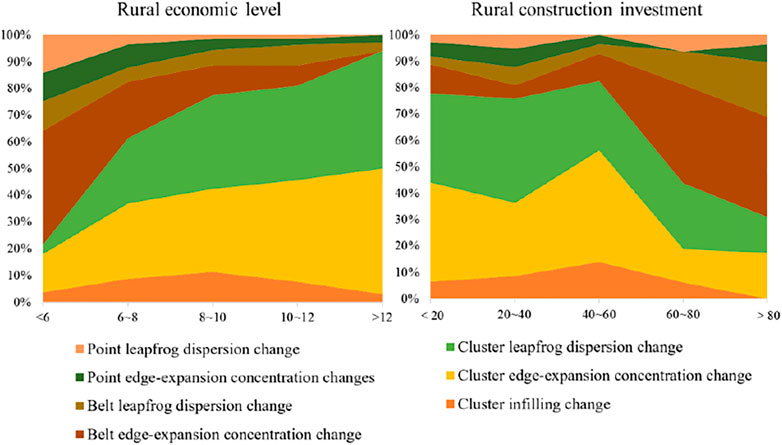
FIGURE 13. Distribution characteristics of the dynamic spatial pattern of RRL under the economic-political gradient.
The RRL with a per capita income level higher than 10,000 yuan is dominated by cluster leapfrog dispersion change pattern and cluster edge-expansion concentration change pattern. The layout change pattern of villages with an income level lower than 6,000 yuan is dominated by belt edge-expansion concentration change pattern and point edge-expansion concentration change pattern. This variability indicates that economic activities have an important influence on the spatial change pattern of RRL layout, and the dispersed change characteristics of RRL layout in areas with strong economic activities are obvious, while the RRL layout in economically backward areas is stable and retains more initial natural forms.
There is a correlation between the level of investment in new rural areas and the changing pattern of RRL layout. The RRL layout with a high level of investment in new rural areas is dominated by cluster edge-expansion concentration change pattern and belt edge-expansion concentration change pattern. Policies aimed at rural development and spatial management should not only focus on the improvement of the living environment of remote and dispersed villages but also pay attention to the need for pattern optimization of concentrated villages to prevent them from developing extensive and dispersed development from a regional perspective as a whole.
In this study, seven typical RRL change patterns in the Pinggu were identified by considering the layout of different villages and the change process of RRL patches. Different change patterns show different change processes and directions, but most of the RRLs show a change trend from “disorderly” to “orderly.” This is not possible without the administrative interventions implemented by the Chinese government in recent years, such as the new rural construction and rural revitalization strategies. Of course, policy measures do not affect all RRLs to the same extent and in the same direction, which is why the study was able to identify seven typical patterns of change.
The cluster leapfrog dispersion change pattern and cluster edge-expansion concentration change pattern are the main change patterns, the RRLs in these two patterns are usually located in the open plain area, and the expansion space is less restricted by the topography. However, the cluster edge-expansion concentration change pattern is characterized by outward clustering along the edge of villages, which can be interpreted as the “native growth” of villages and is mainly distributed in western YQ, southern MF and MCY. This pattern can be interpreted as the “local growth” of villages. Although they all show cluster changes and are located in the plain area, the cluster leapfrog dispersion change pattern is influenced by the production environment. Specifically, under the influence of both industrial spillover from the central urban area and the increase in the intrinsic development demand of villages, some new communities and industrial enterprise sites are developed in a leapfrog manner, further resulting in the loosening of the layout of RRLs. The number of RRLs conforming to this pattern is the largest, accounting for 37.55% of the total number in the region, mainly distributed in the villages of DX, DG, WX, and XG around the central urban area. The other five patterns are mainly distributed in hilly areas, which also indicates that the RRL change patterns are diversified by the influence of topography, location and production conditions in hilly areas.
Therefore, the RRL in the flat valley area shows orderly development as a whole, the RRL change pattern in the plain area is dominated by the cluster leapfrog dispersion change pattern and cluster edge-expansion concentration change pattern, and the RRL change pattern in the hilly area is more diverse. The RRL change pattern in the plains was dominated by the cluster leapfrog dispersion change pattern and cluster edge-expansion concentration change pattern, while the RRL change pattern in the hills was more diverse. Among the various change patterns, the cluster leapfrog dispersion change pattern is a kind of RRL change pattern driven by the gathering of multiple factors and inherent development demand. In the context of the implementation of a rural revitalization strategy in China, if the factor input strategy can be formulated to guide other change patterns to cluster leapfrog dispersion change patterns, the “high-quality growth” of villages can be promoted.
Understanding the intrinsic forces driving rural change allows scientific planning to guide the rural revitalization process and achieve sustainable development (Liu and Li, 2017). The environmental factors affecting the spatial distribution and changes in RRL mainly include the natural environment, production environment, and socioeconomic and cultural environment (Wang and Zhang, 2021). In this study, we analyze the relationship between people and land from five environmental gradients, including topographic and geomorphological environment, location environment, production environment, living service environment, and economic policy environment, and analyze the distribution pattern of RRL change patterns. There are significant differences in the regional environmental influences on RRL in different regions (Zou and Wang, 2015). The influence of altitude and slope on the RRL layout shows a relatively obvious vertically decreasing pattern, and the influence of the location environment represented by town proximity and road accessibility on the layout of the RRL shows a significant distance decay pattern. Rural economic development further promotes the active degree of RRL development (Tan and Li, 2013), and the higher the per capita income level is, the higher the degree of RRL spatial expansion, while the layout of RRLs with relatively low-income levels remains relatively stable. While improving the rural habitat, the rural development policy plays a great role in restraining its spatially disorderly decentralized development. It should be noted that arable land, as an important production resource, interacts with RRL (Liu et al., 2010; Su et al., 2011; Han and Lin, 2019; Li et al., 2021; Penghui et al., 2021). The traditional agricultural production environment plays an important role in the formation of the RRL layout, but with the transformation and upgrading of rural production methods, advanced forms of the production environment represented by facility agriculture and rural enterprises are accelerating the evolution of the RRL layout. In 2021, the FAO proposed to “ensure world food security and protect the earth”, and arable land protection is also an important national policy in China, so it is necessary to consider the production environment of traditional agriculture, facility agriculture and rural enterprises in the layout optimization of RRL to realize synergistic development with arable land protection. The development of RRL should be synergistic with the conservation of farmland (Gao et al., 2020).
Throughout the five stages of the influence of China’s policy system on RRL (Table 5), the practice of village improvement, mainly relocating and merging villages and linking urban and rural construction land, has profoundly changed the layout of RRL. The demand for production and living is the most direct driver of the change in the layout of RRL. Taking the layout changes of the village in JHH and HSY of Pinggu as an example, the villages have become neat and uniform after construction, with a staggered layout of new residential houses, which is in sharp contrast to the original loosely organized villages. The change in village layout is conducive to the transformation from a traditional village mainly for agricultural production to a service-oriented village mainly for tourism reception.
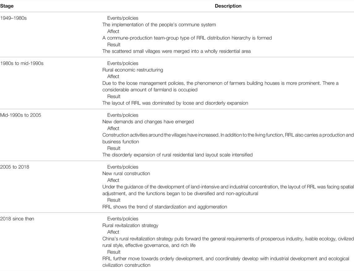
TABLE 5. The 5 stages of China’s policy system impact on RRL.
Therefore, the formulation of policies related to the layout adjustment of RRL should take into account both the needs of people and the carrying capacity of the land. In other words, we should fully consider the ecological function, the level of economic development and the carrying capacity of resources and environment, the flow of rural labor force, and the spatial development of land. There is the need to set reasonable “thresholds” and “ceilings.” It is necessary for the construction of infrastructure, public service facilities, and other hardware materials (e.g., planning a reasonable radius of agricultural production and living services). At the same time, decision-makers need to deal with the relationship between production and living space, as well as the preservation and protection of ecological and cultural resources. In addition, not only should the linkage between new construction and reclamation in scale be considered, but the coordination and orderliness of spatial patterns should also be considered to avoid aggravating the disorderly development of space.
In this study, combining remote sensing data and field research data, the layout types and spatial variation of patches of RRL were used to identify the changing patterns of RRL. It also analyzes their distribution patterns under different environmental gradients and provides a new perspective for analyzing the relationship between rural people and land. Therefore, the methodology and research results of this study provide support for the spatial optimization strategy of RRLs and are of reliable practical significance for promoting sustainable rural development. Compared with the field research data, which can only cover a few villages, and the low accuracy of identifying land types by remote sensing data, the method used in this study covers a wider spatial range, and is more accurate.
However, there are some limitations and uncertainties in this study. The differences in the changing patterns of RRL are formed under the influence of multiple environmental contextual factors that are jointly involved. Therefore, an integrated quantitative model is needed in the future to identify the combined effects of complex environmental factors on the spatial change patterns of RRL. Second, the research conducted in the Pinggu and the discovered RRL change patterns can only provide a direct reference for areas with similar natural and socioeconomic conditions; for different countries and regions, the spatial optimization strategy of RRL should be adjusted according to the specific change patterns.
This study explores the shape, distribution, size and change characteristics of RLL in the Pinggu and identifies the spatial change pattern of RRL. On this basis, the distribution characteristics of the change patterns under the environmental gradients of topography, location, production conditions, public service, economy and policy are analyzed to reveal the laws of spatial evolution of RRL layout in the area of rapid urbanization and rural transformation and development. The study shows that the DRL cluster type and CRL cluster type are the main types of RRL layouts in the Pinggu, and the area of RRL patches in the Pinggu increased by 686.89 hm2 from 2005 to 2015, represented by the cluster leapfrog dispersion change pattern and cluster edge-expansion concentration change pattern. The main spatial change patterns of the RRL layout are the belt leapfrog dispersion change pattern and point edge-expansion concentration change pattern. The regional variability of environmental background factors plays a different role in the generation of spatial change patterns of RRL. The distribution of the pattern of RRL shows a decreasing trend under the topography and location gradients set in this paper. The production environment changes the evolutionary tendency of the spatial pattern of RRL. As a next step, the policy should take into account the environmental conditions of villages, move to areas with higher economic strength, high development potential, and good location conditions, and plan a reasonable radius of agricultural production and living services. The retention and protection of ecological and cultural resources should also be done in a manner which contributes to the sustainable development of rural areas.
The raw data supporting the conclusion of this article will be made available by the authors, without undue reservation.
GJ: Conceptualization, Methodology, Data curation, Formal analysis, Writing–original draft. TC: Conceptualization, Data curation, Writing–review and editing. RZ: Conceptualization, Supervision, Writing–review and editing. YT: Writing–review and editing. SW: Writing–review and editing.
This research was supported by the National Natural Science Foundation of China (Grant Nos.42071249, 41671519, and 42001199), and the National Social Science Fund of China (20&ZD090).
The authors declare that the research was conducted in the absence of any commercial or financial relationships that could be construed as a potential conflict of interest.
All claims expressed in this article are solely those of the authors and do not necessarily represent those of their affiliated organizations, or those of the publisher, the editors and the reviewers. Any product that may be evaluated in this article, or claim that may be made by its manufacturer, is not guaranteed or endorsed by the publisher.
Bai, X., Shi, P., and Liu, Y. (2014). Society: Realizing China's Urban Dream. Nature 509, 158–160. doi:10.1038/509158a
Beilin, R., Lindborg, R., Stenseke, M., Pereira, H. M., Llausàs, A., Slätmo, E., et al. (2014). Analysing How Drivers of Agricultural Land Abandonment Affect Biodiversity and Cultural Landscapes Using Case Studies from Scandinavia, Iberia and Oceania. Land Use Policy 36, 60–72. doi:10.1016/j.landusepol.2013.07.003
Chen, C., Gao, J., and Chen, J. (2017). Institutional Changes, Land Use Dynamics, and the Transition of Rural Settlements in Suburban China: A Case Study of Huishan District in Wuxi City. Habitat Int. 70, 24–33. doi:10.1016/j.habitatint.2017.09.011
Conrad, C., Rudloff, M., Abdullaev, I., Thiel, M., Löw, F., and Lamers, J. P. A. (2015). Measuring Rural Settlement Expansion in Uzbekistan Using Remote Sensing to Support Spatial Planning. Appl. Geogr. 62, 29–43. doi:10.1016/j.apgeog.2015.03.017
Elshof, H., and Bailey, A. (2015). The Role of Responses to Experiences of Rural Population Decline in the Social Capital of Families. J. Rural Community Dev. 10 (1), 72–93. doi:10.2307/1526116
Elshof, H., Haartsen, T., van Wissen, L. J. G., and Mulder, C. H. (2017). The Influence of Village Attractiveness on Flows of Movers in a Declining Rural Region. J. Rural Stud. 56, 39–52. doi:10.1016/j.jrurstud.2017.07.004
Gao, J., Jiang, W., Chen, J., and Liu, Y. (2020). Housing-Industry Symbiosis in Rural China: A Multi-Scalar Analysis Through the Lens of Land Use. Appl. Geogr. 124, 102281.
Ge, D., Wang, Z., Tu, S., Long, H., Yan, H., Sun, D., et al. (2019). Coupling Analysis of Greenhouse-Led Farmland Transition and Rural Transformation Development in China's Traditional Farming Area: A Case of Qingzhou City. Land Use Policy 86, 113–125. doi:10.1016/j.landusepol.2019.05.002
Han, S. S., and Lin, W. (2019). Transforming Rural Housing Land to Farmland in Chongqing, China: The Land Coupon Approach and Farmers' Complaints. Land Use Policy 83, 370–378. doi:10.1016/j.landusepol.2019.02.001
Hirons, M., Robinson, E., McDermott, C., Morel, A., Asare, R., Boyd, E., et al. (2018). Understanding Poverty in Cash-Crop Agro-Forestry Systems: Evidence from Ghana and Ethiopia. Ecol. Econ. 154, 31–41. doi:10.1016/j.ecolecon.2018.07.021
Hoggart, K., and Paniagua, A. (2001). What Rural Restructuring? J. Rural Stud. 17, 41–62. doi:10.1016/s0743-0167(00)00036-x
Ito, J., Bao, Z., and Ni, J. (2016). Land Rental Development via Institutional Innovation in Rural Jiangsu, China. Food Policy 59, 1–11. doi:10.1016/j.foodpol.2015.12.005
Jiang, G. H., Zhang, F. R., Qin, J., Zhang, L., and Gong, P. (2006). Relationshio between Distribution Changes of Rural Residential Land and Environment in Mountainous Areas of Beijing. Trans. Chin. Soc. Agric. Eng. 11, 85–92. doi:10.3321/j.issn:1002-6819.2006.11.018 (In Chinese).
Leyk, S., Ruther, M., Buttenfield, B. P., Nagle, N. N., and Stum, A. K. (2014). Modeling Residential Developed Land in Rural Areas: A Size-Restricted Approach Using Parcel Data. Appl. Geogr. 47, 33–45. doi:10.1016/j.apgeog.2013.11.013
Li, G., Jiang, G., Jiang, C., and Bai, J. (2018). Differentiation of Spatial Morphology of Rural Settlements from an Ethnic Cultural Perspective on the Northeast Tibetan Plateau, China. Habitat Int. 79, 1–9. doi:10.1016/j.habitatint.2018.06.002
Li, H., Yuan, Y., Zhang, X., Li, Z., Wang, Y., and Hu, X. (2019). Evolution and Transformation Mechanism of the Spatial Structure of Rural Settlements from the Perspective of Long-Term Economic and Social Change: A Case Study of the Sunan Region, China. J. Rural Stud. doi:10.1016/j.jrurstud.2019.03.005
Li, L., Wang, L., and Qi, Z. (2021). The Spatiotemporal Variation of Farmland Use Transition and its Critical Influential Factors in Coordinated Urban-Rural Regions: A Case of Chongqing in Western China. Sustain. Cities Soc. 70, 102921. doi:10.1016/j.scs.2021.102921
Li, Y., Liu, Y., Long, H., and Cui, W. (2014). Community-Based Rural Residential Land Consolidation and Allocation Can Help to Revitalize Hollowed Villages in Traditional Agricultural Areas of China: Evidence from Dancheng County, Henan Province. Land Use Policy 39, 188–198. doi:10.1016/j.landusepol.2014.02.016
Li, Y., Westlund, H., Zheng, X., and Liu, Y. (2016). Bottom-up Initiatives and Revival in the Face of Rural Decline: Case Studies from China and Sweden. J. Rural Stud. 47, 506–513. doi:10.1016/j.jrurstud.2016.07.004
Liao, L., Long, H., Gao, X., and Ma, E. (2019). Effects of Land Use Transitions and Rural Aging on Agricultural Production in China's Farming Area: A Perspective from Changing Labor Employing Quantity in the Planting Industry. Land Use Policy 88, 104152. doi:10.1016/j.landusepol.2019.104152
Liu, X. L., Wang, Y., Li, Y., and Wu, J. S. (2019). Quantifying the Spatio-Temporal Process of Township Urbanization: A Large-Scale Data-Driven Approach. ISPRS Int. J. Geo-Inf. 8, 389. doi:10.3390/ijgi8090389
Liu, X. P., Li, X., Chen, Y. M., Qin, Y., Li, S. Y., and Chen, M. H. (2009). Landscape Expansion Index and its Applications to Quantitative Analysis of Urban Expansion. Acta Geogr. Sin. 64, 1430–1438. (In Chinese). doi:10.3321/j.issn:0375-5444.2009.12.003
Liu, Y., and Li, Y. (2017). Revitalize the World's Countryside. Nature 548, 275–277. doi:10.1038/548275a
Liu, Y. S., Wang, J. Y., and Long, H. L. (2010). Analysis of Arable Land Loss and its Impact on Rural Sustainability in Southern Jiangsu Province of China. J. Environ. Manag. 91, 646–653. doi:10.1016/j.jenvman.2009.09.028
Long, H., Ge, D., Zhang, Y., Tu, S., Qu, Y., and Ma, L. (2018). Changing Man-Land Interrelations in China's Farming Area under Urbanization and its Implications for Food Security. J. Environ. Manag. 209, 440–451. doi:10.1016/j.jenvman.2017.12.047
Lotfi, S., and Koohsari, M. J. (2009). Measuring Objective Accessibility to Neighborhood Facilities in the City (A Case Study: Zone 6 in Tehran, Iran). Cities 26, 133–140. doi:10.1016/j.cities.2009.02.006
Newburn, D., and Berck, P. (2011). Exurban Development. J. Environ. Econ. Manag. 62, 323–336. doi:10.1016/j.jeem.2011.05.006
Ottomano Palmisano, G., Govindan, K., Loisi, R. V., Dal Sasso, P., and Roma, R. (2016). Greenways for Rural Sustainable Development: An Integration between Geographic Information Systems and Group Analytic Hierarchy Process. Land Use Policy 50, 429–440. doi:10.1016/j.landusepol.2015.10.016
Paquette, S., and Domon, G. (2001). Trends in Rural Landscape Development and Sociodemographic Recomposition in Southern Quebec (Canada). Landsc. Urban Plan. 55, 215–238. doi:10.1016/s0169-2046(01)00154-2
Penghui, J., Dengshuai, C., and Manchun, L. (2021). Farmland Landscape Fragmentation Evolution and its Driving Mechanism from Rural to Urban: A Case Study of Changzhou City. J. Rural Stud. 82, 1–18. doi:10.1016/j.jrurstud.2021.01.004
Qiao, W. F., Wu, J. G., Zhang, X. L., Ji, Y. Z., Li, H. B., and Wang, Y. H. (2013). Optimization of Spatial Distribution of Rural Settlements at County Scale Based on Analysis of Farming Radius——a case study of Yongqiao District in Anhui Province. Resour. Environ. Yangtze Basin 22, 1557–1563. (In Chinese).
Qu, Y., Jiang, G., Yang, Y., Zheng, Q., Li, Y., and Ma, W. (2018). Multi-Scale Analysis on Spatial Morphology Differentiation and Formation Mechanism of Rural Residential Land: A case study in Shandong Province, China. Habitat Int. 71, 135–146. doi:10.1016/j.habitatint.2017.11.011
Rey, V., and Bachvarov, M. (1998). Rural Settlements in Transition – Agricultural and Countryside Crisis in the Central-Eastern Europe. GeoJournal 44, 345–353. doi:10.1023/a:1006850525893
Sevenant, M., and Antrop, M. (2007). Settlement Models, Land Use and Visibility in Rural Landscapes: Two Case studies in Greece. Landsc. Urban Plan. 80, 362–374. doi:10.1016/j.landurbplan.2006.09.004
Silva, J. V., Baudron, F., Reidsma, P., and Giller, K. E. (2019). Is Labour a Major Determinant of Yield Gaps in Sub-Saharan Africa? A Study of Cereal-Based Production Systems in Southern Ethiopia. Agric. Syst. 174, 39–51. doi:10.1016/j.agsy.2019.04.009
Su, S., Zhang, Q., Zhang, Z., Zhi, J., and Wu, J. (2011). Rural Settlement Expansion and Paddy Soil Loss Across an Ex-Urbanizing Watershed in Eastern Coastal China During Market Transition. Reg. Environ. Change 11, 651–662. doi:10.1007/s10113-010-0197-2
Tan, M., and Li, X. (2013). The Changing Settlements in Rural Areas Under Urban Pressure in China: Patterns, Driving Forces and Policy Implications. Landsc. Urban Plan. 120, 170–177. doi:10.1016/j.landurbplan.2013.08.016
Tao, Z., Guanghui, J., Wenqiu, M., Guangyong, L., Yanbo, Q., Yingying, T., et al. (2021). Dying Villages to Prosperous Villages: A Perspective From Revitalization of Idle Rural Residential Land (IRRL). J. Rural Stud. 84, 45–54. doi:10.1016/j.jrurstud.2021.02.010
Tebboth, M. G. L., Conway, D., and Adger, W. N. (2019). Mobility Endowment and Entitlements Mediate Resilience in Rural Livelihood Systems. Glob. Environ. Change 54, 172–183. doi:10.1016/j.gloenvcha.2018.12.002
Tian, G., Qiao, Z., and Zhang, Y. (2012). The Investigation of Relationship Between Rural Settlement Density, Size, Spatial Distribution and its Geophysical Parameters of China using Landsat TM Images. Ecol. Model. 231, 25–36. doi:10.1016/j.ecolmodel.2012.01.023
Tu, S., Long, H., Zhang, Y., Ge, D., and Qu, Y. (2018). Rural Restructuring at Village Level Under Rapid Urbanization in Metropolitan Suburbs of China and its Implications for Innovations in Land Use Policy. Habitat Int. 77, 143–152. doi:10.1016/j.habitatint.2017.12.001
Turner, M. D., McPeak, J. G., and Ayantunde, A. (2014). The Role of Livestock Mobility in the Livelihood Strategies of Rural Peoples in Semi-Arid West Africa. Hum. Ecol. 42, 231–247. doi:10.1007/s10745-013-9636-2
Wang, J., and Zhang, Y. (2021). Analysis on the Evolution of Rural Settlement Pattern and Its Influencing Factors in China from 1995 to 2015. Land 10 (11), 1137. doi:10.3390/land10111137
Wang, X. G., Xi, J. C., and Kong, Q. Q. (2016). Solid and Hollowed Villiges: Study on the Spatial Polarization of Tourist Villages' Land Use Pattern——A Case Study of two Villages in Yesanpo Tourism Area, Hebei Province. J. Nat. Resour. 31, 90–101. (In Chinese). doi:10.11849/zrzyxb.20141259
Wickham, J. D., Stehman, S. V., Gass, L., Dewitz, J., Fry, J. A., and Wade, T. G. (2013). Accuracy Assessment of NLCD 2006 Land Cover and Impervious Surface. Remote Sens. Environ. 130, 294–304. doi:10.1016/j.rse.2012.12.001
Wilczak, J. (2017). Making the Countryside More Like the Countryside? Rural Planning and Metropolitan Visions in Post-Quake Chengdu. Geoforum 78, 110–118. doi:10.1016/j.geoforum.2016.10.007
Wu, Y., Luo, J., Zhang, X., and Skitmore, M. (2016). Urban Growth Dilemmas and Solutions in China: Looking Forward to 2030. Habitat Int. 56, 42–51. doi:10.1016/j.habitatint.2016.04.004
Xu, F., Ho, H. C., Chi, G., and Wang, Z. (2019). Abandoned Rural Residential Land: Using Machine Learning Techniques to Identify Rural Residential Land Vulnerable to be Abandoned in Mountainous Areas. Habitat Int. 84, 43–56. doi:10.1016/j.habitatint.2018.12.006
Yang, R., Liu, Y. S., Long, H. L., and Zhang, Y. J. (2015). Research Progress and Prospect of Rural Transformation and Reconstruction in China: Paradigms and Main Content. Prog. Geogr. 34, 1019–1030. (In Chinese). doi:10.18306/dlkxjz.2015.08.009
Zachrisson, A., Bjärstig, T., Thellbro, C., Neumann, W., and Svensson, J. (2021). Participatory Comprehensive Planning to Handle Competing Land-Use Priorities in the Sparsely Populated Rural Context. J. Rural Stud. 88, 1–13. doi:10.1016/j.jrurstud.2021.09.031
Zhang, R. J., Jiang, G. H., Wang, M. Z., Ma, W. Q., and He, X. (2015). Layout Classification of Rural Settlement Based on Combination of Multi-Dimensional Characteristics. Trans. Chin. Soc. Agric. Eng. 31, 286–292. (In Chinese). doi:10.3969/j.issn.1002-6819.2015.04.040
Zhang, X. L. (1998). On Discrimination of Rural Definitions. Acta Geogr. Sin. 53, 365–371. (In Chinese). doi:10.11821/xb199804009
Zhang, Y., Long, H., Ma, L., Tu, S., Liao, L., Chen, K., et al. (2019). How Does the Community Resilience of Urban Village Response to the Government-Led Redevelopment? A Case Study of Tangjialing Village in Beijing. Cities 95, 102396. doi:10.1016/j.cities.2019.102396
Keywords: rural residential land, spatial pattern, environmental gradient, dynamic and multi-scale, pinggu
Citation: Jiang G, Chen T, Zhang R, Tian Y and Wu S (2022) A Spatial Patterns Identification Method of Rural Residential Land Change Integrating Dynamic and Multi-Scale Information. Front. Environ. Sci. 10:902556. doi: 10.3389/fenvs.2022.902556
Received: 23 March 2022; Accepted: 19 April 2022;
Published: 13 May 2022.
Edited by:
Wenqiu Ma, China Agricultural University, ChinaReviewed by:
Huawu Wu, Nanjing Institute of Geography and Limnology (CAS), ChinaCopyright © 2022 Jiang, Chen, Zhang, Tian and Wu. This is an open-access article distributed under the terms of the Creative Commons Attribution License (CC BY). The use, distribution or reproduction in other forums is permitted, provided the original author(s) and the copyright owner(s) are credited and that the original publication in this journal is cited, in accordance with accepted academic practice. No use, distribution or reproduction is permitted which does not comply with these terms.
*Correspondence: Ruijuan Zhang, emhhbmdydWlqdWFuMDcyMkB5ZWFoLm5ldA==
Disclaimer: All claims expressed in this article are solely those of the authors and do not necessarily represent those of their affiliated organizations, or those of the publisher, the editors and the reviewers. Any product that may be evaluated in this article or claim that may be made by its manufacturer is not guaranteed or endorsed by the publisher.
Research integrity at Frontiers
Learn more about the work of our research integrity team to safeguard the quality of each article we publish.