- 1Faculty of Geography, University of Belgrade, Belgrade, Serbia
- 2Departament of Geography, Tourism and Hotel Management, Faculty of Sciences, University of Novi Sad, Novi Sad, Serbia
- 3Belgrade Business and Arts Academy of Applied Studies, Belgrade, Serbia
- 4Faculty of Economics, University of Belgrade, Belgrade, Serbia
The key problem of rural settlements in the South Banat district lasted into the 21st century through the spread of depopulated areas. Considering that settlements give a cultural landscape its basic features, that they are the main bearers of functional organization, and the hotspots of geo-spatial transformation, based on quantitative-qualitative indicators this paper analyzes the spatial-demographic determinants of the development of 94 settlements, and the impact of depopulation on the changes in the surrounding forest cover. The time span included in the analytical-statistical research of the demographic components and forest dislocation lasted from 1990 to 2018. Geo-spatial data for forest areas were taken from the Corine Land Cover database. The data obtained were then turned into visual representations, or maps, using the GIS ArcMap 10.8. software. The results indicated that total depopulation has been an ongoing, 30-years process in this area on the one hand, while the forest cover in the depopulated settlements located on the outskirts of the Deliblato sands (a special nature reserve) has decreased, and the forest cover in the depopulated settlements in the zone of the Vršac mountains has increased, on the other. These analyses are useful for obtaining more detailed insight into the state of forested areas in this part of Serbia, which is the least afforested one.
Introduction
Forests are important as a climatic modifier, a natural air filter (Valjarević et al., 2021), habitat for game, source of timber for industry and for fuel, and as recreation and leisure areas (Boisvenue and Running, 2006; Bonan, 2008; Đerčan et al., 2012; Lubowiecki-Vikuk et al., 2021; Gatarić and Ðerčan, 2021). The preservation of forests depends on sustainable development, as well as the environmental progress of the planet (Achard et al., 2002; Valjarević et al., 2018).
The total forested surface of the world is 4,06 billion hectares (ha), which is 31 percent of the total land surface. This amounts to 0,52 ha per capita, even though forests are not equally distributed among countries geographically (FAO, 2020). An increase in the number of inhabitants and economic activity leads to the depletion of the forest fund. The increase in the number of inhabitants first and foremost leads to an increase in the expansion of agricultural surfaces at the expense of forests, as well as an increase in the consumption of wood as fuel, and then leads to industrialization and urbanization, leaving an impact on the forest cover (Angelsen, 1999; Alain, 2000; Foster and Rosenzweig, 2003; DeFries et al., 2010; Mmom and Mbee, 2013). Since 1990 the world has lost 178 million ha of forests, which is a surface the area of Libya. Despite that, the rate of net loss of the forest cover has significantly decreased from 1990 to 2020 due to a decrease in deforestation in some countries; however, there has been an increase in the forest cover in others through reforestation, and the natural expansion of forests (FAO, 2020). The main factors which contribute to deforestation in some parts of the world include poverty, low income, and population growth. The most important cause of deforestation is rapid population growth, which leads to an increase in the demand for crops and pastures, and timber for fuel and construction (Dyson, 1994; Geist and Lambin, 2002; Carr et al., 2005; Drummond and Loveland, 2010; Byerlee et al., 2014; Martínez-Valderrama et al., 2022).
The population and the environment are closely linked in a complex and dynamic way. This relationship depends on a series of socio-economic, cultural, political, and developmental aspects (Cropper and Griffiths, 1994; Frederick and Meyerson, 2003; De Souza et al., 2003). A large number of studies focused on the relationship between changes in both (Agrawal, 1995; Baumgartner, 2019). One of the more important questions of the modern age is the question of population growth and whether land resources could endure this rapid growth in most parts of the world (UNFPA, 1991; Debel et al., 2014). While population growth and density are undoubtedly related to the trends in forest cover changes (Williams, 2006), there is no simple way to describe or predict this link. It is not surprising that the relationship is as complex as the regional and cultural variations in human societies, and the changes in these societies over time.
Ecological principles and empirical findings which indicate population growth, social and economic development, and the quality of the environment are in a high and complex mutual dependence. In order to better understand this system, it is important to analyze it on a theoretical level. At the same time, it is necessary to focus on just a few of the numerous variables, so as to recognize the key cause and effect relationships.
Several theories have attempted to clarify how the population and development impact the quality of the environment. They could be classified into two categories: the first one includes theories which focus on the direct relationship between the population, development, and the environment, which is why they are also called direct effects theories, while the others are referred to as indirect effects theories (Winstein and Pillai, 2001).
One of the more popular direct effect theories of environmental degradation is the one based on Malthus’s work. Today’s neo-Malthusianism emphasizes the negative effects of population growth on the environment and on the quality of life in general (Ehrlich and Ehrlich, 1990; Myers, 1991; Abernathy, 1993). An extensive and growing population is considered the deciding factor for poverty, water pollution, deforestation, the decrease in air quality, and all other forms of pressure exerted on the environment. With population growth, renewable sources are spent quicker than they can be renewed. This kind of “race” results in a depopulation crisis. Malthus believed that such a crisis can manifest in war, epidemics, hunger, poverty. Today, however, this indicates an ecological collapse (UNFPA, 1991). With an increase in the mortality rate and the weakening of (bio)reproduction, the effect of an ecological breakdown is a fall in population growth, and thus, finally, a population decline, which lasts until the next cycle of population growth and crises.
The opposing school of thought, which is best represented by Julian Simon, claims that population growth is desirable. It points out that, throughout history, society has found the solutions to overcome the problems it has faced. What emerged from that point of view is that population growth will also mean a greater probability that a solution for our environmental problems will be found (Simon, 1981; Simon et al., 1983; Simon, 1990).
One of the theories which focuses on the indirect relationship between population, development, and the environment points out that the level of social-economic independence of a country is an important determiner of the impact its population will have on the environment (Jolly, 1991). The deforestation in Latin America and South-East Asia, the exploitation of fertile areas for mass and cheap production of industrial material are linked to considerable profits in developed countries. Another theory from the indirect effect group is that population growth increases the depletion of resources and exerts pressure on the ecosystem. Increased land cultivation can endanger the environment, leading to deforestation and soil degradation in particular. The pressure on natural resources over times encourages demographic changes, such as postponing marriage, a lower birthrate, and emigration, which is also reflected in the negative population growth. Thus, we can conclude that natural and demographic factors emerge together and lead to changes in the environment.
The study of the inverse relationships between the population and forest covers in scientific circles has been a point of interest for more than two centuries (Mather and Needle, 2000). Harrison (1992) cites that population growth is responsible for 79% of the global deforestation between 1973 and 1988.
Studies carried out in the 1980s and 1990s discovered a strong link between population growth and deforestation in Central America, East and West Africa, and South Asia, but a considerably less clear link in Amazonia (South America) and Central Africa (Pfaff, 1999; Rudel et al., 2000). On the other hand, in numerous developed countries, such as the US, China, and Russia, a recovery in the forest cover has been noted after previous extensive deforestation.
Based on existing studies on deforestation it is possible to make several generalizations. In the case of exceptionally low population density (less than one to two people per square kilometer), it is possible to maintain large areas of intact forests in places where the population can sustain itself by harvesting non-timber forest products, and not through agriculture. However, even in sparsely populated areas, external factors such as the demand for timber in other parts of the country or the world can lead to deforestation which is not closely linked to the growth of the local population.
Since the agricultural population density increases in the vicinity of woodland, a strong link is noted between population growth and deforestation, since the local population migrates towards the outskirts of woodland complexes and harvests forests to provide greater areas for agricultural production. When it comes to soil of poor quality, the lower the agricultural production per ha, the greater the probability that more forests will be destroyed per capita.
Meyerson (2004) cites that the situation is different in developed countries. The population relies less and less on agriculture as the source of its livelihood, while agriculture relies more and more on capital and technology, and less on the workforce. Furthermore, the need for food, fuel, and timber can be met by importing from other areas of the country and the world. Based on examples from the US, India, and China, it can be concluded that despite the significant population growth during the 1990s, there has been a greater net increase in forest coverage. The general principle derived from the experiences of these countries can be that after the transition from the initial phase of deforestation, a combination of a shortage of wood products and growing economic wealth can lead a society to establish its true values, reforestation, and forest management (Allen and Barnes, 1985).
Depopulation is an ongoing process on the European continent (Eberhardt, 1993; Lukić et al., 2012). It is particularly prominent in less developed and developing countries, and Serbia is no exception in that respect (Rikalović et al., 2016). Ediev (2001) used a mathematical model to precisely determine that population growth leads to a decrease in demographic potential. During the final decades of the 20th and beginning of the 21st century, even the settlements in the South Banat district were affected by depopulation. It has been the root cause of their complete devastation, not only in a demographic but also in a broader economic and social sense.
Even though it is quite clear that demographic changes impact the use of resources, population growth is only one variable from a greater group of important variables whose numerous interactions affect natural resources. The neo-Malthusian perspective on deforestation singles out an important fact—that there is a direct link between the increase in population density and deforestation. However, the strong correlation between these two phenomena leads us to conclude that population growth is the only significant variable which impacts forests, when this is clearly not the case. A compelling argument in favor of the neo-Malthusian perspective is based on theory and available evidence. The sudden decline in the rural population in certain provinces in Indonesia is not accompanied by a noticeable decrease in the deforestation rate and forest degradation (Kummer and Turner, 1994; Sunderlin and Resosudarmo, 1999).
Since most studies deal with the link between population growth and density and deforestation, this study poses the opposite question: what happens in cases when population growth and density are in decline? Is it possible to stop or slow down deforestation?
This paper studies the link between demographic movement and changes in the forest cover on a sample of 94 settlements in the South Banat district in Serbia over the past 30 years. The general aim of this study is to evaluate the effect of the population decline on forest resources in the area of the South Banat district in Serbia. The specific goals of this study include an analysis of the depopulation trend of the studied area, and an analysis of the changes in the forest cover in relation to negative demographic trends.
Study Area
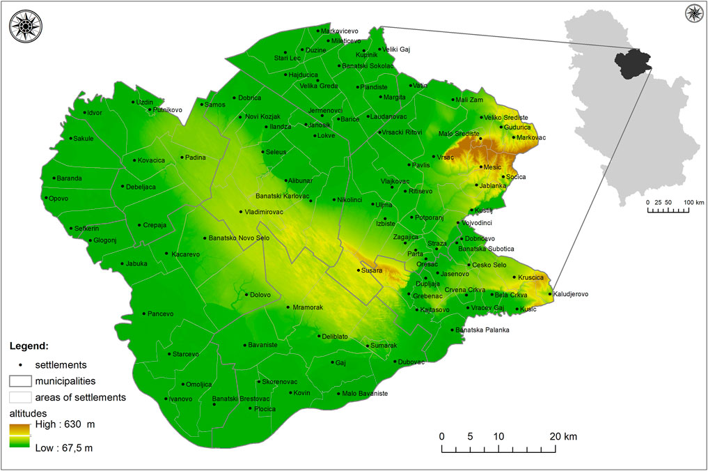
The South Banat district spans an area from the north of the Republic of Serbia to the south-east of the Autonomous province of Vojvodina (Figure 1). It is surrounded by the rivers Danube and Tamiš, to the east it borders Romania, and to the north it borders with the municipalities of the Central Banat district - Sečanj and Zrenjanin. In includes 8 municipalities: Bela Crkva, Vršac, Plandište, Alibunar, Kovin, Pančevo, Kovačica, and Opovo. It covers an area of 4,246 km2 of which 3,897 km2 are rural areas SORS (2021). The South Banat district includes 94 settlements, with 293,730 inhabitants, of which 125,444 or 42.7% live in rural settlements. The largest number of inhabitants live in Pančevo (76,203), which is also the administrative center of the district, while the fewest reside in the settlement of Laudonovac near Plandište (21 inhabitants). Accordingly, the greatest population density is in Pančevo (165 inhabitants per km2), which is almost double the national average (81.34 citizens).
In the South Banat district we find the Special national reserve “Deliblato sands”, which spans the area of the municipalities of Alibunar, Vršac, Bela Crkva, and Kovin, and covers an area of 34,829.32 ha (Vojvodinasume, 2022). It has been protected since 2002 and represents the greatest oasis of the sand-steppe and forest vegetation which had once dominated the Pannonian Plain1. Until the Second World War approximately 2400 of its hectares had been reforested. After the Second World War to this day there has been intense reforestation (Milenković et al., 2018).
The eastern part of the research area, along the border with Romania, is an area of extraordinary features, the Vršac mountains. Most of the mountain extends along the borders of Serbia, while a smaller part is found in Romania. The highest peak of the Vršac mountains is the peak Gudurički vrh (641 m.a.s.l.), which is at the same time the highest peak in Vojvodina. The Vršac mountains are spatially located in the municipality of Vršac. They have been under protection since 2005, and cover an area of 4,371 ha2.
Materials and Methods
For the analysis and construction of maps, the ArcGIS 10.8 by ESRI and Microsoft Excel software was used. The shapefiles used in the coordinate system of MGI Balkans 7 include: the state territory of Serbia, the South Banat district, its municipalities, and the settlement areas. The Digital elevation model of the terrain (DEM model), with a resolution of 10 m × 10 m (Figure 1), was used for the visualisation of the study area.
For data on the land cover, that is, the way in which land is being used, the Corine Land Cover database for 1990, 2000, 2006, 2012 and 2018 was used. Changes were expected based on the differences between the recorded years. In this study, the forests were divided into three categories according to the Land Cover—European Environmental Agency (CORINE) methodology. The total area was calculated by adding all three types of forests: broadleaf forests, mixed forests, and coniferous forests. Categories of the layers of forests were differentiated and categorized into a hierarchy of three levels. The classes of forests are marked as 311—Broadleaf, 312—Coniferous and 313—Mixed.
Data on the land cover for the research area during the studied years were obtained using the “Clip” tool. The “Merge” tool was used to combine the polygons of the broadleaf, coniferous and mixed forests, and these polygons of forests were used for analysis. In order to obtain a difference in the forest area between the initial and final year (1990 and 2018), data on the forests were converted into raster form using the “Polygon to Raster” tool, so that the “Raster Calculator” could be used (Nestorov and Protić, 2009; Spruce et al., 2020). Thus, maps were obtained which chart changes in the forest cover with three types of areas:
- areas where there were no forests in 1990, while there are forests in 2018 (an increase in forest areas)
- areas where there were forests in 1990, but there are none in 2018 (a reduction in forest areas)
- areas where there were no forests at both recorded points in time.
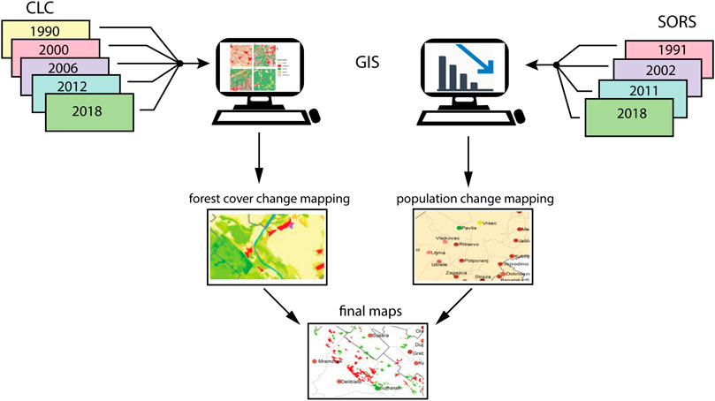
The “Tabulate Area” tool was used to obtain data on the areas on which an increase or decrease in the forest cover was noted for each settlement area in the South Banat district. The tool provided data on each settlement area in terms of forest growth, deforestation, and areas without change in the number of pixels. The data was then, using Excel and the settlement area, converted into hectares (Heymann et al., 1994). The overlap between these data and the demographic movement database provided the basis for Figures 5, 6. The flowchart of the applied methodology is shown in Figure 2.
The depopulation process was analyzed based on complex indicators. The demographic indicators used were actually data from the Statistical Office of the Republic of Serbia (SORS) regarding the number of inhabitants in each area included in the Census of 1991, 2002, and 2011 (SORS, 2011a). They are presented as relative values. The estimated number of citizens in mid-2018 (as of June 30, 2018) was calculated based on data from the population census, data on the population growth, and data on internal migrations.
Vital statistics data from the Statistical Office of the Republic of Serbia were also used to calculate the type of population movement. The calculations were made using the Clark model, based on which three types of population movement were identified in the South Banat district (Nejašmić, 2005; Vojković, 2007; Tošić et al., 2009; Jeftić, 2019). Types of settlements were determined depending on which components had the greatest impact on population growth or decline. These include emigration or exodus: total depopulation (dying out, E4), which indicates one negative migration balance and two immigration ones, regeneration through immigration (I2), and very weak regeneration through immigration (I4), with a positive migration balance but of varying intensity. The basic features of these types of settlements include:
E4—a negative natural change, negative movement determined by the census and a rate of natural change (decline) which is lower than the rate of decline recorded during the census, I2—a negative natural change, positive movement determined by the census and a rate of increase noted during the census which is greater than the rate of natural change (decline), I4—a negative natural change, negative movement determined by the census and a rate of decline determined during the census which is lower than the rate of natural change (decline) (Friganović, 1978; Nejašmić, 2005).
Data on the settlement area, on the total forest area, and the changes in the number of inhabitants were analyzed using SPSS (Statistical Software for Social Sciences) 23. The analysis used in the study is the ANOVA test and the Pearson correlation test.
Results
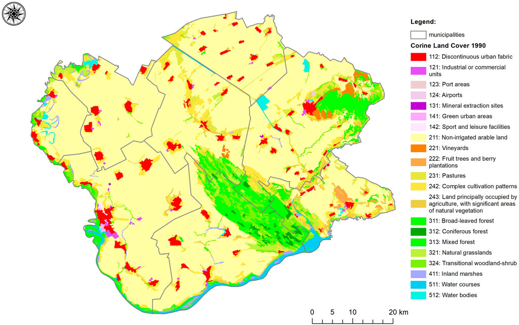
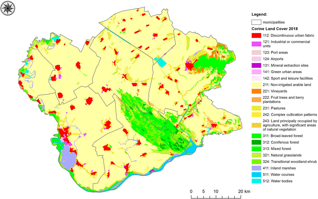
According to the Corine Land Cover data from 2018, in the South Banat district forests and forest areas covered approximately 32,700 ha, which represents 7.7% of the total district area, or only 0.1 ha per capita. Forests are predominantly of a mixed character (class 313) and stretch along the Vršac mountains, Deliblato sands and the valley of the Karaš river (Figures 3, 4). The monodominant forests of the Vršac mountains are covered in Black Locust (Robinia Pseudoacacia), Sessile Oak (Quercus Petraea), and Silver Lime (Tilia Argentea). In the Deliblato sands we find mixed broad-leaved forests consisting of: the Common Oak (Quercus Robur), the Sessile Oak, Black Locust, Poplar wood (Populus nigra, Populus alba), the Linden tree (Tilia cordata), Maple wood (Acer pseudoplatanus), and coniferous forests consisting of: the Black pine (Pinus nigra) and White pine (Pinus sylvestris). Freshwater swamp forests are composed predominantly of White ash (Fraxinus excelsior), Willow (Salix alba), Poplar wood (Populus nigra, Populus alba), and Elm trees (Ulmus minor). Poplars and willow trees are prevalent along the alluvial plains, around backwaters, ponds, swamps and canals. Around settlements we find forests of poplars and black locust, interspersed with white ash and maple2.
The area of the Deliblato sands is mostly covered by the forests classified as level III protection, as much as 14,870 ha, while the most valuable forests from the aspect of environmental protection are classified as levels I and II and cover an area of 2.1 ha. The forests are to the greatest extent the result of reforestation over the past two centuries.
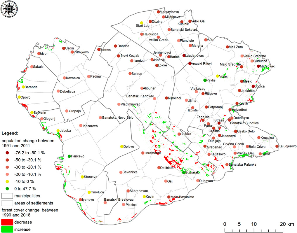
The forest area in the South Banat district from 1990 to 2018 has been reduced by approximately 20 ha. A decrease in the forest cover was noted in 17 settlements, and an increase in 33 settlements (Table 1). No changes to the forest cover were noted on the territory of most settlements during the studied period. The greatest decrease in the forest cover was noted for the settlements of Deliblato, Dubovac and Malo Bavanište. The greatest increase was noted for the settlements of Markovac, Kusić and Vračev Gaj.
From 1991 to 2011, the settlements from the South Banat district were characterized by continued demographic decline caused by migration and the constant population decline. From 1991 to 2002, of the total number of settlements (94), 3 had a positive population growth rate: Kusić, Crvena Crkva and Šumarak, while from 2002 to 2011, the rate was negative in all the settlements (Table 2).
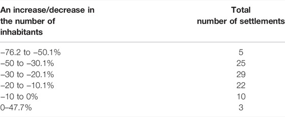
TABLE 2. The number of settlements based on the intensity of the inter-census changes from 1991 to 2011.
The rural population during the studied period (1991-2011) reduced numerically from 155,538 to 125,444 inhabitants, while at the same time the share of urban citizens increased from 52.6 % to 57.3%. Only the settlements of Pančevo, Pavliš and Šumarak showed an increase in the number of inhabitants, but due to resettlement and not population growth (Gatarić et al., 2016). Specifically, in addition to the settlement of Pančevo, which is a subsystem of the Belgrade agglomeration (Krunić, 2012), the settlement of Pavliš is a suburb of the town of Vršac whose individual parts have in a morphological sense merged with the city center. In that context, the population concentration and economic activities in cities significantly impacts the quality of the environment as well. All this endangers the process of sustainable urban development, and furthermore impacts the local social-economic and ecological systems (Morar et al., 2021). An increase in the number of inhabitants in the settlement of Šumarak, which is located on the territory of the municipality of Kovin, occurred when it morphed from a temporary weekend settlement into a permanent one. At the same time, the settlement saw an increase in the forest cover (Figure 5).
Analyzing the migration balance at the level of the settlements from 1991 to 2011, 78 settlements in the South Banat district had a negative migration balance. This means that these settlements are of the total depopulation type (E4), that is, are characterized by the population dying out. Their concentration is highest in settlements located on the territory of the following municipalities: Alibunar, Bela Crkva, Kovačica, Kovin, Opovo, Plandište and Vršac (Figure 6) (Gatarić et al., 2016). Long-term depopulation is reflected in the ageing of the population and the weakening of the biodynamic potential. Based on age, the population of the South Banat district is in a deep demographic ageing stage. According to the Census of 2011, the mean age for the district was 41.9, which is an increase from the mean age of 39.9 recorded in the Census of 2002 (SORS, 2011b). This value indicates that the South Banat district is affected by population ageing. The causes of the increase in the mean values of the population age include population decline, the extended life span, and migration. The oldest population was recorded in the municipality of Alibunar, whose inhabitants on average were 44.7 years old (42.2 is the national average). The analysis of the average age of the population at the level of the settlements has clearly indicated that the oldest population lives in the settlement of Vršački Ritovi on the territory of the City of Vršac (with an average age of 53.1 years), followed by Banatski Sokolac in the municipality of Plandište (51.1 years) (SORS, 2011b). Nejašmić (1992) cites that such an ageing population brings with it a decrease in economic activity as well. Over the past 30 years it has also been reflected in the forestry service employment rate.
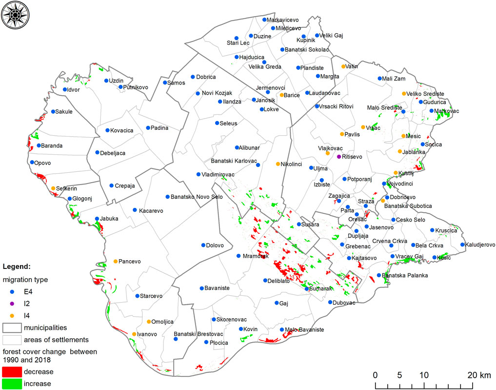
FIGURE 6. The link between the type of movement of the population, settlements, and the forest cover.
Discussion
Previous studies determined that deforestation highly correlates with the logarithm of population density (Pahari and Murai, 1999). However, this fact is negated by this study of the territory of the South Banat district. There are two zones in this district: one of increase and one of decrease in the forest cover in the depopulated settlements. Even though the settlements on the outskirts of the Deliblato sands are depopulated, the forest cover has decreased, while in the depopulated settlements in the Vršac mountains the forest cover has increased. In addition, the urban settlements of Pančevo and Šumarak recorded an increase in the number of inhabitants during the studied period, but also an increase in the forest cover. That means that we cannot make a general claim that a decrease in the forest cover is influenced solely by the increase in the number of inhabitants and vice versa.
The mutual dependence between the settlement area and the forest cover was tested by the ANOVA. The results indicated that there is a statistically significant difference (F = 11.051, p = 0.000) between the settlement area and changes in the forest cover. The LSD post hoc test indicated that settlements with the greatest area have undergone the greatest forest cover transformations. A significant correlation (r = 0.459, p = 0.000) was also noted between the settlement area and the change in the number of inhabitants. A statistically significant difference between the number of inhabitants and changes in the forest area has not been determined.
These relations are also visible on cartographic representations (Figures 5, 6). The greatest decrease in the forest cover was noted on the territory of the settlements in the Deliblato sands or its immediate vicinity—Deliblato (−680 ha), Dubovac (−160 ha), Kajtasovo (−80 ha). In addition, a significant decrease in the forest area was noted in the alluvial plains of the Danube river to the south and in the settlement area of Malo Bavanište (−310 ha), but also to the west of the research area, in the settlement areas of Sefkerin (−120 ha) and Opovo (−110 ha). At the same time, Deliblato, Dubovac, Kajtasovo, Malo Bavnište and Opovo belong to the group of settlements characterized by total depopulation (E4 on Figure 6), that is, depopulation. Only the settlement of Sefkerin belongs to the group of settlements characterized by very weak regeneration through immigration. These data speak in favor of the thesis that depopulation does not have a considerable impact on the decrease of forest exploitation.
In the east part of the research area, especially in the area of the Vršac mountains, we can note a different situation. There we find areas with a forest cover that has increased over the past 30 years. In the Vršac mountains we find the greatest increase in the forest cover, particularly in the settlement areas of Markovac (+250 ha), Vršac (+100 ha) and Mesić (+20 ha). At the very south-east, along the river Nera and the border with Romania, the greatest increase in the forest cover was noted on the territory of the settlements of Kusić (+140 ha), Vračev Gaj (+130 ha), and Banatska Palanka (+50 ha). When it comes to the demographic development of these settlements, most belong to the E4 type of settlement, which is characterized by complete depopulation. Only the settlements of Vršac and Mesić are settlements of the I4 type, and are characterized by very weak regeneration through immigration. These trends speak in favor of the thesis that depopulation does have an impact on the decrease in forest exploitation.
These notable differences in the changes to the forest cover on a relatively small area require that other factors, other than demographic ones, be taken into consideration. It was determined that the decrease in forest areas, in addition to demographic, are also influenced by anthropogenic factors. Considerable forest areas have been destroyed in fires as well. The greatest fire in the Deliblato sands lasted from August 10 to 16, 1996. At that time, fire destroyed 3.815,4 ha (247.206 m3 of timber, of which 230.895 m3 coniferous and 16.311 m3 broad-leafed trees) (Munćan et al., 2004). The greatest increase in the forest cover was noted on the territory of Markovac, Vršac, and Pančevo. In these settlements, except for Pančevo, a simultaneous decrease in the number of inhabitants was noted.
The decrease in the forest area in the South Banat district which was noted in the records dating from 2000 is a consequence of the fire which affected the area of the Deliblato sands in 1996. In the following years it was possible to monitor the recovery of the forest fund, and the rising trend of the forest cover growth. Contrary to that, 1991 and on saw a population decline (Figure 7).
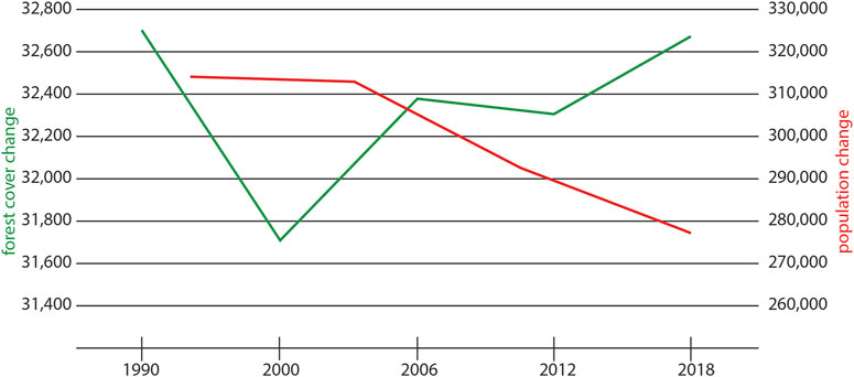
FIGURE 7. A comparative overview of the changes in the forest cover (1990-2018) and the number of inhabitants (1991-2018*). *Estimated number of inhabitants.
During the last inter-census period, no population growth was recorded in any of the settlements. What is alarming, but is a fact, is the emergence of depopulated areas. In certain years within the studied period, and in some settlements, no children had been born. Such is the case of the settlement of Laudonovac in the municipality of Plandište where only one child was born, and Vršački Ritovi on the territory of the City of Vršac where three children were born, etc. (Gatarić et al., 2016).
The population decline need not only be a consequence of the drop in population growth, but also of excessive migration. Juniwaty et al. (2019) cite that migrations, especially of the male workforce from rural to urban areas for the purpose of education, which additionally create costs for rural areas, can lead to the intensification of agriculture, and thus to deforestation. The longevity and intensity of the process of depopulation, which will continue into the foreseeable future, was indicated by the demographic projections that by 2030 the total population of the South Banat district would decrease by an additional 70,000 inhabitants (Nikitović, 2019).
Conclusion
This study has determined that changes in the forest cover correlate with demographic changes. When it comes to the changes in the forest cover, our analysis has identified differences between two zones: a zone of increase and a zone of decrease in the forest cover. On the other hand, the demographic indicators show that all settlements have been engulfed by the depopulation process and are in an advanced stage of deep demographic ageing. The settlements on the outskirts of the Deliblato sands are marked by depopulation, but have at the same time undergone a decrease in the forest cover, while in the depopulated settlements on the Vršac mountains there has been an increase in the forest cover. The main reason for the decrease in the forest cover in the Deliblato sands includes fire.
With only 7.7% of the forest area, the South Banat district is insufficiently forested, not only compared to other parts of Serbia but also in comparison to numerous regions throughout Europe. What is encouraging is the fact that lately a rising trend has been noted in the expansion of the forest cover, which is benefitting from the natural process of forest renewal and reforestation. Thanks to negative demographic changes which characterize this region, such as depopulation and emigration, the forest areas have increased since 2000. All the main trends and changes, in general, indicate the importance of anthropogenic influence, both in the deforestation process and in the reforestation process. What speaks in favor of the preservation of the forest complex is the fact that the Spatial Plan of the Special Purpose Area of the Special Nature Reserve “Deliblato sands” (2006) states that the forest area has reached 17.9% of the total land area. In addition, the Spatial Plan of the Republic of Serbia from 2021 to 20303 proposes that the Deliblato sands be added to the UNESCO list of natural biosphere reserves. Special treatment of this area (a special nature reserve and a biosphere reserve) requires various protection regimes and specific forms of business and economic activities. With an adequate system of protection and education, and conditions for the sustainable management of forests, an increase in the forest cover can be achieved in the future. At the same time, the local population must be active in spreading the findings of ecological research, as well as findings from other sciences which deal with forest preservation.
It was noted that there are several limitations in this research, which could be avoided in future work. First, as an addition to demographic indicators, future research should include variables such as economic activity, the rate of industrialization, deagrarization, and planned urbanization. Thus, further research focused on the impact of other social and cultural factors needs to be carried out if we want to achieve an adequate understanding of the processes which impact the use and/or degradation of forest resources. Second, the extent of the research could be expanded into other regions of Serbia. Considering that the Vršac mountains extend into nearby Romania, it would be interesting to conduct research in the part of Romania that borders the South Banat district. In addition, similar studies could be carried out in other countries in our surroundings, those which share the same or similar patterns of demographic and economic development (primarily in the countries of former Yugoslavia), as well as in other mid or less developed countries of Europe and the rest of the world.
However, this paper does provide a broad contribution to obtaining more detailed insight into the state of the forests in this area, and for the sustainable management of forests in the future. Further studies should also contribute to the increased use of digital technologies and the analysis of the complex phenomenon of the mutual relationship between the population and forest complexes.
Data Availability Statement
The original contributions presented in the study are included in the article/Supplementary Material, further inquiries can be directed to the corresponding author.
Author Contributions
The project design was developed by DG and BĐ. The project was implemented by DG with input from BĐ, MŽ, MO and TL. The article was drafted by DG and BĐ. The article was reviewed by SM, MS, TL, MJ, MlL and ML, revised and submitted by BĐ. All authors contributed to the article and approved the submitted version.
Funding
The authors acknowledge financial support of the Ministry of Education, Science and Technological Development of the Republic of Serbia (Grant No. 200091 and 451-03-68/2022-14/200125), and Provincial Secretariat for Higher Education and Scientific Research (Grant No. 142-451-2615/2021-01/1).
Conflict of Interest
The authors declare that the research was conducted in the absence of any commercial or financial relationships that could be construed as a potential conflict of interest.
Publisher’s Note
All claims expressed in this article are solely those of the authors and do not necessarily represent those of their affiliated organizations, or those of the publisher, the editors and the reviewers. Any product that may be evaluated in this article, or claim that may be made by its manufacturer, is not guaranteed or endorsed by the publisher.
Footnotes
1Author Anonymous (2006). Spatial Plan of the Special Purpose Area of the Special Nature Reserve “Deliblato Sands”. Novi Sad: Provincial Secretariat for Architecture, Urbanism and Construction. Official Gazette APV 8/06.
2Author Anonymous (2021a). Spatial Plan of the Special Purpose Area of the “Vršac Mountains”. Novi Sad: Provincial Secretariat for Urbanism and Environmental Protection. Official Gazette APV 9/21.
3Author Anonymous (2021b). Spatial Plan of the Republic of Serbia from 2021 to 2030. Belgrade: Ministry of Construction, Traffic, and Infrastructure.
References
Abernathy, V. (1993). Population Politics: The Choices that Shape Our Future. New York: Plenum/Insight.
Achard, F., Eva, H. D., Stibig, H.-J., Mayaux, P., Gallego, J., Richards, T., et al. (2002). Determination of Deforestation Rates of the World's Humid Tropical Forests. Science 297 (5583), 999–1002. doi:10.1126/science.1070656
Agrawal, A. (1995). Demographic Pressure = forest Degradation: An Oversimplistic Equation? Unasylva 181 (46), 50–58.
Alain, M. (2000). Population and the Environment: A Review and Concepts for Population Programmes. Part III: Population and Deforestation. Rome: FAO.
Allen, J. C., and Barnes, D. F. (1985). The Causes of Deforestation in Developing Countries. Ann. Assoc. Am. Geogr. 75 (2), 163–184. doi:10.1111/j.1467-8306.1985.tb00079.x
Angelsen, A. (1999). Agricultural Expansion and Deforestation: Modelling the Impact of Population, Market Forces and Property Rights. J. Develop. Econ. 58 (1), 185–218. doi:10.1016/S0304-3878(98)00108-4
Author Anonymous, (2006). Spatial Plan of the Special Purpose Area of the Special Nature Reserve “Deliblato Sands”. Novi Sad: Provincial Secretariat for Architecture, Urbanism and Construction. Official Gazette APV 8/06.
Author Anonymous, (2021a). Spatial Plan of the Special Purpose Area of the "Vršac Mountains". Novi Sad: Provincial Secretariat for Urbanism and Environmental Protection. Official Gazette APV 9/21.
Author Anonymous, (2021b). Spatial Plan of the Republic of Serbia from 2021 to 2030. Belgrade: Ministry of Construction, Traffic, and Infrastructure. Draft.
Baumgartner, R. J. (2019). Sustainable Development Goals and the Forest Sector-A Complex Relationship. Forests 10 (2), 152. doi:10.3390/f10020152
Boisvenue, C., and Running, S. W. (2006). Impacts of Climate Change on Natural forest Productivity - Evidence since the Middle of the 20th century. Glob. Change Biol. 12 (5), 862–882. doi:10.1111/j.1365-2486.2006.01134.x
Bonan, G. B. (2008). Forests and Climate Change: Forcings, Feedbacks, and the Climate Benefits of Forests. Science 320 (5882), 1444–1449. doi:10.1126/science.1155121
Byerlee, D., Stevenson, J., and Villoria, N. (2014). Does Intensification Slow Crop Land Expansion or Encourage Deforestation? Glob. Food Security 3 (2), 92–98. doi:10.1016/j.gfs.2014.04.001
Carr, D. L., Suter, L., and Barbieri, A. (2005). Population Dynamics and Tropical Deforestation: State of the Debate and Conceptual Challenges. Popul. Environ. 27 (1), 89–113. doi:10.1007/s11111-005-0014-x
Cropper, M., and Griffiths, C. (1994). The Interaction of Population Growth and Environmental Quality. Am. Econ. Rev. 84 (2), 250–254.
De Souza, R. M., Williams, J., and Meyerson, F. A. B. (2003). Critical Links: Population, Health, and the Environment. Popul. Bull. 58 (3), 3–42.
Debel, F., Tilahun, U., and Chimdesa, D. (2014). The Impact of Population Growth on Forestry Development in East Wollega Zone: the Case of Haro Limu District. J. Nat. Sci. Res. 4 (18), 85–91.
DeFries, R. S., Rudel, T., Uriarte, M., and Hansen, M. (2010). Deforestation Driven by Urban Population Growth and Agricultural Trade in the Twenty-First century. Nat. Geosci. 3, 178–181. doi:10.1038/ngeo756
Đerčan, B., Lukić, T., Bubalo-Živković, M., Đurđev, B., Stojsavljević, R., and Pantelić, M. (2012). Possibility of Efficient Utilization of wood Waste as a Renewable Energy Resource in Serbia. Renew. Sustain. Energ. Rev. 16 (3), 1516–1527. doi:10.1016/j.rser.2011.10.017
Drummond, M. A., and Loveland, T. R. (2010). Land-use Pressure and a Transition to forest-cover Loss in the Eastern United States. BioScience 60 (4), 286–298. doi:10.1525/bio.2010.60.4.7
Dyson, T. (1994). Population Growth and Food Production: Recent Global and Regional Trends. Popul. Develop. Rev. 20 (2), 397–411. doi:10.2307/2137524
Eberhardt, P. (1993). Depopulation Processes in the Rural Areas in East-central Europe (1950- 1990). East. Eur. Countryside 0, 31–40.
Ediev, D. (2001). Application of the Demographic Potential Concept to Understanding the Russian Population History and Prospects. DemRes 4 (9), 289–336. doi:10.4054/demres.2001.4.9
Ehrlich, R. P., and Ehrlich, H. A. (1990). The Population Explosion. New York: Touchstone, Simon and Schuster, Inc.
Foster, A. D., and Rosenzweig, M. R. (2003). Economic Growth and the Rise of Forests. Q. J. Econ. 118 (2), 601–637. doi:10.1162/003355303321675464
Frederick, A., and Meyerson, B. (2003). Population, Biodiversity and Changing Climate. Adv. Appl. Biodiversity Sci. 4, 83–90.
Gatarić, D., and Ðerčan, B. (2021). “Sustainable Development of Rural Tourist Settlements in Serbia: Building A Better Future for All,” in Handbook of Sustainable Development and Leisure Services. Editors A. Lubowiecki-Vikuk, B. M. Barbosa de Sousa, B. M. Đerčan, and W. Leal Filho (Cham: Springer), 171–183. doi:10.1007/978-3-030-59820-4_12
Gatarić, R. D., Vrbnik, A., and Ivanišević, M. (2016). Demographic Development of Settlements in the South Banat County/District. Forum Geogr. 15 (1), 91–96. doi:10.5775/fg.2016.011.i
Geist, H. J., and Lambin, E. F. (2002). Proximate Causes and Underlying Driving Forces of Tropical Deforestation. BioScience 52 (2), 143–150. doi:10.1641/0006-3568(2002)052[0143:pcaudf]2.0.co;2
Harrison, P. (1992). The Third Revolution: Population, Environment and a Sustainable World. Harmondsworth: Penguin.
Heymann, Y., Steenmans, Ch., Croissille, G., and Bossard, M. (1994). CORINE Land Cover – Technical Guide. Luxembourg: Official Publications of the EC.
Jeftić, M. (2019). Funkcionalno Urbani Region U Prostornom Planiranju. Beograd: Geografski fakultet.
Jolly, C. (1991). “Four Theories of Population Change and the Environment,” in The Population Association of America Annual Meeting, Washington, DC, 21-23 March.
Juniwaty, K. S., Basnett, B. S., Thung, P. H., Sanjaya, I. M., and Busra, M. I. (2019). Connecting the Dots in the Forest-Migration Nexus: A Case Study from Malinau, Indonesia. Working Paper 250. Bogor, Indonesia: Center for International Forestry Research, CIFOR. doi:10.17528/cifor/007306
Krunić, N. (2012). Demografski Aspekti Savremene Prostorno-Funkcijske Organizacije Mreže Naselja Vojvodine. Demografija 9, 121–146.
Kummer, D. M., and Turner, B. L. (1994). The Human Causes of Deforestation in Southeast Asia. Bioscience 44 (5), 323–328. doi:10.2307/1312382
Lubowiecki-Vikuk, A., Đerčan, B. M., and de Sousa, B. M. B. (2021). “Sustainable Development and Leisure Services: Changes and Trends,” in Handbook of Sustainable Development and Leisure Services. Editors A. Lubowiecki-Vikuk, B. M. Barbosa de Sousa, B. M. Đerčan, and W. Leal Filho (Cham: Springer), 1–20. doi:10.1007/978-3-030-59820-4_1
Lukić, T., Stojsavljević, R., Ðurdev, B., Nađ, I., and Ðerčan, B. (2012). Depopulation in the Western Balkan Countries. Eur. J. Geogr. 3 (2), 6–23.
Martínez-Valderrama, J., del Barrio, G., Sanjuán, M. E., Guirado, E., and Maestre, F. T. (2022). Desertification in Spain: A Sound Diagnosis without Solutions and New Scenarios. Land 11, 272. doi:10.3390/land11020272
Mather, A. S., and Needle, C. L. (2000). The Relationships of Population and forest Trends. Geograph. J. 166 (1), 2–13. doi:10.1111/j.1475-4959.2000.tb00002.x
Meyerson, F. A. B. (2004). Population Growth and Deforestation: A Critical and Complex Relationship. Washington: Population Reference Bureau. Available at: https://www.prb.org/resources/population-growth-and-deforestation-a-critical-and-complex-relationship/.
Milenković, M., Munćan, S., and Babić, V. (2018). Dva Veka Pošumljavanja Deliblatske Peščare: Problem Šumskih Požara. Šumarstvo 3–4, 1–24.
Mmom, P. C., and Mbee, D. M. (2013). Population Pressure and Forest Resources Depletion in Gele – Gele Forest Reserve of Edo State, Nigeria. Inter. J. Phy. Hum. Geo. 1 (3), 31–42.
Morar, C., Lukić, T., Basarin, B., Valjarević, A., Vujičić, M., Niemets, L., et al. (2021). Shaping Sustainable Urban Environments by Addressing the Hydro-Meteorological Factors in Landslide Occurrence: Ciuperca Hill (Oradea, Romania). Int. J. Environ. Res. Public Health 18 (9), 5022. doi:10.3390/IJERPH18095022
Munćan, S., Tomović, Z., Munćan, M., and i Milenković, M. (2004). Najveći Šumski Požar U Istoriji Deliblatske Peščare. Specijalni Rezervat Prirode “Deliblatska Peščara”, Zbornik Radova VII, Javno Preduzeće “Vojvodinašume” Novi Sad, Šumsko Gazdinstvo “Banat” Pančevo. str, 251–260.
Myers, N. (1991). “The World's Forests and Human Populations: The Environmental Interconnections,” in Resources, Environment, and Population: Present Knowledge, Future Options. Editors K. Davis, and M. Bernstam (New York: Oxford University Press).
Nejašmić, I. (1992). Promjene U Dobno-Spolnom Sastavu Stanovništva Istočnojadranskog Otočja (1953-1991). Acta Geograph. Croatica 27 (1), 15–34.
Nejašmić, I. (2005). Demogeografija: Stanovništvo U Prostornim Odnosima I Procesima. Zagreb: Školska knjiga.
Nestorov, I., and Protić, D. (2009). CORIN Kartiranje Zemlјišnog Pokrivača U Srbiji. Beograd: Građevinska knjiga.
Nikitović, V. (2019). U Susret Regionalnoj Depopulaciji U Srbiji. Beograd: Institut društvenih nauka.
Pahari, K., and Murai, S. (1999). Modelling for Prediction of Global Deforestation Based on the Growth of Human Population. ISPRS J. Photogram. Remote Sensing 54 (5–6), 317–324. doi:10.1016/S0924-2716(99)00032-5
Pfaff, A. S. P. (1999). What Drives Deforestation in the Brazilian Amazon? J. Environ. Econ. Manage. 37 (1), 26–43. doi:10.1006/jeem.1998.1056
Rikalović, G., Molnar, D., and i Mikić, H. (2016). “Ruralni Razvoj I Kreativna Ekonomija,” in U Stanje I Perspektive Agroprivrede I Sela U Srbiji (Beograd: Univerzitet u Beogradu Ekonomski fakultet).
Rudel, T. K., Flesher, K., Bates, D., Baptista, S., and Holmgren, P. (2000). Tropical Deforestation Literature: Geographical and Historical Patterns. Unasylva 203 (51), 11–18.
Simon, J. L., Reisler, W., and Gobin, R. (1983). 'Population Pressure' on the Land: Analysis of Trends Past and Future. World Develop. 11 (9), 825–834. doi:10.1016/0305-750x(83)90094-3
Simon, J. (1990). Population Matters: People, Resources, Environment and Integration. New Brunswick, NJ: Transaction Publishers.
SORS (2011a). Census of Population, Households and Dwellings in the Republic of Serbia, Comparative Overview of the Number of Population 1948, 1953, 1961, 1971, 1981, 1991, 2002, 2011, Data by Settlements. Available at: http://www.stat.gov.rs/ (Accessed January, 2022).
SORS (2011b). Census of Population, Households and Dwellings in the Republic of Serbia. Age and Sex, Data by Settlements. Available at: http://www.stat.gov.rs/ (Accessed Jan, 2022).
SORS (2021). Municipalities and Regions of the Republic of Serbia, Belgrade: Statistical Office of the Republic of Serbia.
Spruce, J., Bolten, J., Mohammed, I. N., Srinivasan, R., and Lakshmi, V. (2020). Mapping Land Use Land Cover Change in the Lower Mekong Basin from 1997 to 2010. Front. Environ. Sci. 8, 21. doi:10.3389/fenvs.2020.00021
Sunderlin, W., and Resosudarmo, I. A. P. (1999). The Effect of Population and Migration on Forest Cover in Indonesia. J. Environ. Develop. 8 (2), 152–169. doi:10.1177/107049659900800204
Tošić, D., Krunić, N., and i Milijić, S. (2009). Istraživanje Prostorne Organizacije Mreže Naselja U Funkciji Izrade Prostornog Plana Opština Južnog Pomoravlja. Demografija 6, 173–194.
UNFPA (1991). Population Resources and Environment: The Critical Challenges. New York: United Nations Fund for Population Activities.
Valjarević, A., Djekić, T., Stevanović, V., Ivanović, R., and Jandziković, B. (2018). GIS Numerical and Remote Sensing Analyses of forest Changes in the Toplica Region for the Period of 1953–2013. Appl. Geogr. 92, 131–139. doi:10.1016/j.apgeog.2018.01.016
Valjarević, A., Morar, C., Živković, J., Niemets, L., Kićović, D., Golijanin, J., et al. (2021). Long Term Monitoring and Connection between Topography and Cloud Cover Distribution in Serbia. Atmosphere 12 (8), 964. doi:10.3390/atmos12080964
Vojković, G. (2007). Stanovništvo Kao Element Regionalizacije Srbije. Beograd: Srpsko geografsko društvo.
Vojvodinasume (2022). Internet 1. Available at: https://www.vojvodinasume.rs/ (Accessed Feb, 2022).
Keywords: forest, GIS, spatial analysis, settlements, land cover changes, spatial-demographic transformation
Citation: Gatarić D, Đerčan B, Živković MB, Ostojić M, Manojlović S, Sibinović M, Lukić T, Jeftić M, Lutovac M and Lutovac M (2022) Can Depopulation Stop Deforestation? The Impact of Demographic Movement on Forest Cover Changes in the Settlements of the South Banat District (Serbia). Front. Environ. Sci. 10:897201. doi: 10.3389/fenvs.2022.897201
Received: 15 March 2022; Accepted: 28 March 2022;
Published: 14 April 2022.
Edited by:
Cezar Morar, University of Oradea, RomaniaReviewed by:
Valentina Nikolova, University of Mining and Geology “Saint Ivan Rilski”, BulgariaSvemir Gorin, Saints Cyril and Methodius University of Skopje, North Macedonia
Copyright © 2022 Gatarić, Đerčan, Živković, Ostojić, Manojlović, Sibinović, Lukić, Jeftić, Lutovac and Lutovac. This is an open-access article distributed under the terms of the Creative Commons Attribution License (CC BY). The use, distribution or reproduction in other forums is permitted, provided the original author(s) and the copyright owner(s) are credited and that the original publication in this journal is cited, in accordance with accepted academic practice. No use, distribution or reproduction is permitted which does not comply with these terms.
*Correspondence: Bojan Đerčan, Ym9qYW4uZGplcmNhbkBkZ3QudW5zLmFjLnJz
 Dragica Gatarić1
 Bojan Đerčan
 Milka Bubalo Živković
 Miloš Ostojić
 Mikica Sibinović
 Marija Jeftić