 Xiaoke Guan
 Xiuli Wang2
- 1Social Development Research Center of Zhengzhou University of Light Industry, Zhengzhou, China
- 2College of Resource and Environmental Sciences, Henan Agricultural University, Zhengzhou, China
The marginalization of farmland is the progression of farmland utilization from high to low net profit, and the abandonment of farmland is its extreme form, and cultivated land marginalization is an important problem that needs to be properly controlled in the process of economic and social development. In this paper, cultivated land was extracted from the land database and evaluated from the aspects of natural suitability, farming convenience and farming opportunity cost, etc. By setting the combined weight of the three evaluation results and stacking them with the forest land extracted from remote sensing images, the potential risk range of cultivated land marginalization was identified, and an empirical study was carried out in Mengjin County, Henan Province. Results showed that: 1) the natural factors of cultivated land were stable and not easy to change, and the natural suitability was the basic condition that affected the marginalization of cultivated land. There was a spatial correlation between the natural suitability of cultivated land and the cultivation convenience, and the risk of marginalization of cultivated land with poor natural suitability and inconvenient cultivation conditions was higher. 2) The high-opportunity cost areas are mainly distributed in the inner suburbs of cities, and the cultivated land in this area is highly likely to be adjusted to high-benefit agriculture such as flowers, vegetables and sightseeing agriculture. Therefore, the risk of abandonment of cultivated land is less. 3) Adjusting cultivated land with poor natural suitability and inconvenient tillage conditions to forest land is conducive to the restoration of regional fragile ecology. Comprehensive improvement of cultivated land with high natural suitability but inconvenient tillage is an important way to delay the marginalization of cultivated land. This study provides a new idea for the formulation of farmland marginalization prevention and control policies at county level.
1 Introduction
The marginalization of farmland is the progression from high to low net profit of farmland utilization, and the abandonment of farmland is its extreme expression (Aide and Grau, 2004). Since the reform and opening up of China and with rapid urbanization, job opportunities for farmers have increased substantially, and non-farm incomes have increased rapidly, these increases have led to increased migration of the workforce from rural to urban areas and non-farming sectors (Xin et al., 2011). From 2002 to 2013, the average reduction in the agriculture workforce in China was 11.33 million persons (Li et al., 2017). Due to the influences of both a continuous increase in non-farm incomes and a gradually declining proportion of farm income to the total income of rural families, the opportunity cost of farming has increased extensively. This phenomenon is especially pronounced in remote mountainous regions that have been experiencing significant migration of young workers from farming villages to non-agriculture sectors. Because the agricultural sector is labor intensive, the decline and aging of the workforce and the continuous marginalization of low-quality farmland exemplified by hillside farmland have led to the abandonment of farmland with poor production quality and yield (Rudel et al., 2005; Edward et al., 2010; Baumann et al., 2011; Strijker, 2005; Li and Zhao, 2011).
The marginalization and abandonment of farmland is a common phenomenon in developed countries in Europe and North America. This trend has attracted the attention of many scholars and governments. In the early 1990s, Mather (1992) coined the term “forest transition,” which refers to situations in which the forested area of a country or a region transitions from net reductions to net increases in a U-shape trend. This phenomenon was first observed in developed countries in Europe and North America and was subsequently observed in Latin America and Southeast Asia (Sklenicka et al., 2014; Ruskulea et al., 2013; Romero-Calcerrada and Perry, 2004; Sayadi et al., 2009; Terres et al., 2015). Alcantara et al. (2012) Using MODIS time series data, Alcatraz et al. Studied the abandonment of farmland in Central and Eastern Europe and found that in 2005, approximately 1/5 of local farmland was abandoned. Studies in Europe, America and new industrial countries have proved that economic growth creates a large number of non-agricultural employment opportunities, which is an important reason for the transformation of inferior farmland into forest land (Li et al., 2017).
China has a large mountainous area and a large proportion of sloping farmland. Restricted by terrain in mountainous areas, mechanization development is blocked. With the massive transfer of labor force in mountainous areas, farmland abandonment in mountainous areas is becoming more and more serious. Shao et al. (2015) made a systematic analysis on the characteristics of farmland marginalization in mountainous areas of China on a large scale based on sampling survey data, and believed that the rise of agricultural labor price increases the cost of farming. In the case of relatively stable agricultural product prices, agricultural production profits are compressed, leading to the marginalization of farmland. Many scholars chose different research regions to conduct empirical analysis (Yan et al., 2016; Li et al., 2017; Li and Li, 2017). The above studies have provided an in-depth understanding of farmland abandonment and forest transformation in mountainous areas of China (Li and Li, 2019). From the microcosmic layer, to give up farming is each family decisions, Zhang et al. (2014) used Wulong county peasant household survey data to prove that the unit land area of agricultural labor less farmers, the higher probability of abandoned. Based on the case of Chongqing, Shi et al. (2016) proved that farmers’ abandonment rate of farmland increased with the increase of cultivation distance, plot elevation and plot slope. In recent years, in the process of agricultural industrial structure adjustment, induced some areas of cultivated land “non-grain” tendency. In some places, the adjustment of agricultural structure is simply understood as reducing grain production, some operators illegally plant trees and dig ponds on basic farmland, and some industrial and commercial capital transfer farmland to non-food crops. Represented by functional decline, the use of cultivated land in many places presents adverse trends such as “marginalization” and “abandonment of farmland” (Li and Li, 2016; Wu et al., 2019; Xue and Zhang, 2017; Zhang, 2016).
Through the above analysis it can be seen that the current research on factors affecting farmland marginalized identification mainly concentrated in two aspects: First, on a macro scale, the development trend of farmland abandonment and forest transformation in mountainous areas was confirmed by using the change rate of mountainous area NDVI and farmland, and it was considered that the limitation of mountainous terrain conditions was the main factor leading to farmland marginalization. This kind of research can effectively reflect the overall situation of farmland marginalization in mountainous areas, but it cannot accurately identify the parcel level and explain the causes of farmland marginalization in plain areas. The second is to examine the impact of parcel and families on farmland abandonment by using household survey data at the micro scale, and to conclude that lack of household labor and lack of farmland transfer are the main factors leading to farmland marginalization. Based on the survey data, this kind of research concludes that if there are too few samples, it is suspected of overgeneralization. If there are too many samples, it is time-consuming, laborious, and not economically feasible. Moreover, it cannot effectively predict the potential risk range of farmland marginalization, and it is easy to form unenforceable “air policy” in specific prevention and control operations.
China has attached great importance to the protection of cultivated land, and established a relatively perfect cultivated land protection system (Liu et al., 2020; Lu et al., 2021; Zhou et al., 2021). However, due to the gradual, complex, and unstable characteristics of cultivated land marginalization, Furthermore, many factors influence this process, such as environmental conditions, workforce characteristics, the development level of the agricultural sector, geographic conditions, the level of economic development, and agricultural policies. Therefore, the extent of farmland marginalization is expected to vary among villages, types of farmers, and farmland parcels within the same landform unit, resulting in the increasingly serious trend of cultivated land non-grain conversion (Su et al., 2020; Yang and Zhang, 2021; Wang and Hou, 2021). The General Office of the State Council has made it clear that the limited cultivated land resources must be given priority to grain production, and the conversion of cultivated land to forest land, garden land and other types of agricultural land should be strictly controlled. At present, with the upgrading of consumption and the tightening of resources and environment, China’s grain production and demand will maintain a tight balance for a long time. The marginalization of cultivated land is an important symbol of the degradation of cultivated land resources. The disorderly development of cultivated land marginalization is bound to impact on food security. Under the influence of the COVID-19 pandemic and the conflict between Russia and Ukraine, international food prices have been rising. With the alarm of the food crisis sounding, issues related to farmland protection and food security have been escalating again. Therefore, it is of positive and practical significance to identify the potential risk range of future marginalization of cultivated land and formulate targeted prevention and control policies for maintaining food security.
Farmland protection is among the top priorities for the Chinese government (Li, 2019). The “Dynamic Balance of Total Farmland Area Policy” (DBTFA) in the land management system was created to ensure the stability of farmland area in china. Under the enormous pressure to conserve farmland, as one of their performance evaluation criteria, local governments often disregard the actual utilization of farmland in their data on farmland statistics, although some farmland has been abandoned or adjusted to forest land, it is still counted as farmland in the farmland database. Therefore, this study extracted farmland data from the land database, and evaluated the natural suitability of farmland, cultivation convenience and opportunity cost of farmland in a multi-dimensional manner. The weights of different evaluation dimensions were set, and different combination schemes were simulated, which were superimposed with the forest land extracted from remote sensing images to identify the main controlling factors affecting the marginalization of farmland, so as to provide a reference for the formulation of reasonable and effective policies of farmland protection and utilization.
2 Theoretical Framework
2.1 Identification of Farmland Marginalization Factors
Using a stepwise algorithm and taking into account natural suitability, farming conditions, and opportunity cost, we perform a multidimensional analysis of the spatial distribution of farmland marginalization. First, the level of natural suitability is the foundation for the identification of farmland marginalization. Historically, people have selected for use as farmland land that has natural conditions conducive to cultivation. Farmland with poor natural conditions is only cultivated to sustain food supply, and the level of natural suitability even in modern society remains the key consideration in determining whether farmland will be marginalized. Second, as the labor cost of farming continuously grows, adopting large-scale farming and intensified cultivation and replacing manual labor with mechanization are crucial ways to maintain the profitability of the agricultural sector. However, limitations, such as basic infrastructure and farmland parcel size, may render impossible the use of large-scale operations to improve labor productivity. As labor cost increases, areas with small parcels and farmland with inferior farming conditions are likely to be marginalized. Third, in the market economy, the utilization of farmland is also influenced by the level of regional economic development and the efficiency of farmland utilization. The opportunity cost of farming increases as non-farm income and job opportunities increase. When the profitability of the farm equals zero or is negative, a rational farmer will lose the motivation to continue farming. Therefore, farmland in regions with a higher opportunity cost is likely to be marginalized and abandoned. Next, combining the previously described evaluation system and using the integrated weighted model to calculate the total value of single evaluation units, the total value of each evaluation unit is calculated using the frequency histogram of the total score of the evaluation units. Using a natural breakpoint method, we divide the interval for the level of farmland marginalization under the perspective of each dimension.
Last, by assigning different weights to various evaluation dimensions, we simulate the potential risk of marginalization under different scenarios. Using remote sensing images, we analyze the spatial distribution of the reforestation of farmland. Subsequently, using an overlay analysis of remote sensing images, we systematically identify the main factors that contribute to farmland marginalization (Figure 1).
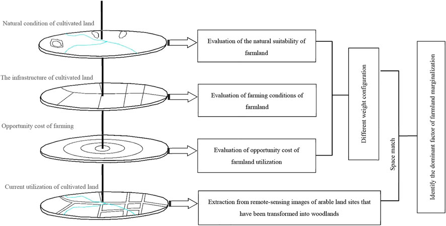
FIGURE 1. Conceptual framework for the identification of marginal factors of farmland.
2.2 Evaluation of the Natural Suitability of Farmland
High-quality farmland is capable of fulfilling the basic elements required for crops to grow, such as sunlight, water, and nutrients, and its soil quality is stable and static and can reveal its basic land conditions. In a traditional agricultural society, the pressure from continuous population growth has led to the cultivation of land with lower natural suitability. As society transforms and labor productivity increases, farmland with lower natural suitability is likely to be marginalized. Classification of agricultural land diagnostic index is to select factors that have a significant impact on the quality of agricultural land. The diagnostic index is divided into different grades or levels to evaluate the natural suitability of cultivated land, which has been included in the national standards. Referring to the agricultural land grading standards where the research area is located, we consider the terrain slope, surface soil quality, soil thickness, organic matter content, and soil structure of the selected area as the evaluation criteria to assess the natural suitability of farmland.
2.2.1 Evaluation Indicators of Natural Suitability
Terrain slope—an important basis for determining farmland quality. Terrain slope is a crucial factor that influences the degree of natural suitability. A higher likelihood of soil degradation exists in an area with a steeper slope. At the same time, fertility and the moisture retention rate will be poorer.
Surface soil quality—has a significant impact on various composite crop growth reactions. Mengjin County is in the transitional zone of the second and third steps. There is also a substantial difference in soil quality within this region, throughout which alluvial soil, cinnamon soil, and red clay are found. Surface quality is one of the most important factors that influences natural suitability.
Soil thickness—thick soil is not only beneficial for crop growth but also provides better moisture retention and fertility.
Organic matter content—for soil, the distribution of nutrients is highly related to its organic matter, and soil with higher organic matter content has better fertility and aggregate structure. Therefore, the level of organic matter content is an important indicator of soil fertility.
Soil structure—an important indicator of soil development. Well-developed soil tends to show a regular and systematic structure, coupled with sufficient thickness and absence of an obstructive layer.
2.2.2 Factor Scoring and Weight Allocation
Using the likelihood of farmland marginalization as the basis of our evaluation, the indicators for the natural suitability of land are categorized into 5 grades, using 5, 4, 3, 2, and 1 to represent the level of natural suitability, where areas with lower natural suitability are more likely to be marginalized. Using agricultural land classifications and grading results as our reference and employing quantitative and qualitative methods, we quantify each factor and determine its weight (Table 1).
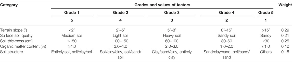
TABLE 1. Evaluation indicators of natural suitability of farmland.
2.3 Evaluation of Farming Conditions of Farmland
Farming conditions are crucial to the condition and utilization level of the farmland. Improving farming conditions can promote higher and more stable agricultural productivity and serves as an effective and important path that ensures higher production and efficiency. Through a series of engineering measures, people attempt to improve the farming conditions of farmland parcels, which increases agricultural efficiency and lowers the cost of farming. Hence, areas with less ideal farming conditions tend to be marginalized. With the increasing popularity of mechanized farming, the convenience of farming should not only consider the farming distance, but also fully consider the suitability of mechanized farming field. Combining data availability and considering the attributes of the research area, this study selects farming distance, connectivity of the roads throughout the farmland, size of the farmland parcels, level of centralization and contiguity of the farmland parcels, and irrigation condition as the criteria with which to evaluate whether farming conditions are ideal.
2.3.1 Indicators of Farming Conditions
Farming distance—Farming distance is the distance between farmland parcels and a farmer’s residential area. Because a certain symbiotic relationship exists in the spatial distribution of the village dwelling and the farmland, there has to be a certain farming radius between the farmland and the farmer’s village of residence. Once a reasonable farming radius is exceeded, the convenience of the farmland will decline drastically.
Interconnectivity of the roads among parcels—The roads among parcels serve as the transport paths for agricultural supplies, mechanized farming, and other agricultural activities. A farming unit with a more convenient road network can provide the basis for higher agricultural productivity. Greater numbers of interconnected roads among farmland parcels lower the cost of mechanization. The connectivity of the road network between parcels is calculated using Formula 1 as follows:
In Formula 1, K is the road connectivity index; m is the number of farmland parcels within the village area with interconnected roads; and M is the total number of farmland parcels within the village area.
Size of the farmland parcels—Farmland parcel size is the unit area of a farmland parcel. Farmland parcels that are small and dispersed have significant negative impacts on the efficiency of mechanized farming, the composite output rate of the farmland, and the efficiency of agricultural production technology. Here, we incorporated the conditions of farmland parcels in Mengjin County to assign values to farmland parcels of different sizes.
Centralization and contiguity level of farmland parcels—The centralized and contiguous nature of the farmland parcels affects the level of agricultural mechanization and its efficiency. This research uses the village as the measurement unit, with the level of farmland centralization as a reflection of contiguity. A higher value means a higher degree of farmland fragmentation or division; in contrast, a lower value shows a lower division and, hence, higher farmland contiguity. The centralization and contiguity of the farmland are calculated using Formula 2 as follows:
In Formula 2, P is the level of farmland centralization and contiguity, L is the total perimeter of the farmland within the village area, and A is the sum of the farmland area within the village.
Irrigation condition—Farmland with good irrigation conditions has higher productivity and, thus, higher profit from operations. Taking into consideration the availability of basic farming infrastructure in the research area as well, we have assigned different values to different types of farmland parcels.
2.3.2 Factor Scoring and Weight Allocation
Combining the actual situation in the research area and the objective of our evaluation, as well as consideration of the level of influence of varying farming conditions on farmland marginalization, we assign values 5, 4, 3, 2, and 1 to score the quality of the evaluation factors. In this way, we are quantifying and grading the farming conditions. For factors that have fewer grades, intermediate values, such as 4 and 2, can be eliminated. An analytic hierarchy process is used to verify the weight allocated to the evaluation factors of the farming conditions (Table 2).
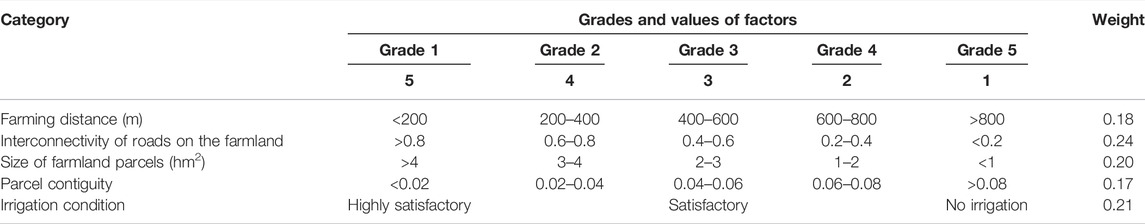
TABLE 2. Evaluation indicators of farmland marginalization based on farming conditions.
2.4 Evaluation of Opportunity Cost of Farmland Utilization
In the urbanization process, the shift of the farming workforce to non-farming sectors is an inevitable trend, and job opportunities in the non-farming sector increase continuously. In turn, this increases the opportunity cost of farming, reduces agricultural investment, and causes extensive usage or even abandonment of farmland. In the current stage, due to the lack of a calculation method to accurately estimate the opportunity cost of farming, combined with the research objective and data availability, this research chooses to use per-capita income, distance to the city, labor allocation, farming scale, and other factors as proxy indicators to collectively represent the opportunity cost of farming in the area.
2.4.1 Evaluation Indicators of the Opportunity Cost of Farming
Per-capita income—as the income in a rural household continues to increase, the percentage of the net income generated from the primary industry continues to decline. Therefore, in a high-income region, the capital and labor invested in farming are declining, and the utilization frequency of farmland is falling. In a low-income region, due to the lack of alternatives to increase their income, farmers tend to more highly value farmland utilization.
Distance to the city—as the city expands, the basic infrastructures in the surrounding rural areas continue to improve, villages that are closer to the city have a higher possibility of benefiting from industry and capital transfer, and as non-farming job opportunities increase, there is a higher likelihood that farmers will find a livelihood outside of agriculture. Consequently, the opportunity cost of farming increases, and thus, the likelihood of farmland marginalization increases.
Labor allocation ratio—in an area in which non-farming job opportunities are more abundant, there is usually almost no excess labor in the rural household. Therefore, the ratio of the village population employed in the agricultural sector can reflect the opportunity cost of farming. Lower farming labor to the total population ratio results in a higher opportunity cost of farming in the said village. Consequently, farmland in villages is more likely to be marginalized. Here, using the village as the unit of measurement, we can calculate the labor allocation ratio using Formula 3 as follows:
In Formula 3, I is the labor allocation ratio; J is the number of people in the village employed in the agricultural sector, referring to individuals who perform agricultural work or businesses; and S is the total population of the village, referring to the total population size of the village.
Dominance index of the farming scale—in large-scale farmland utilization, there will be a scale effect. An area with a higher dominance index of the farming scale has a lower opportunity cost of farming, which lowers the risk of farmland marginalization, and vice versa. The index of the farming scale is calculated using Formula 4 as follows:
In this formula, Qi is the dominance index of the farming scale in village i; Gi and Gz respectively indicate the total farmland area in village i and throughout the entire county; and Ti and Tz respectively indicate the total land area in village i and throughout the entire county.
2.4.2 Factor Scoring and Weight Allocation
In consideration of the complexity of the opportunity cost of farming and the diversity of the factors that influence it and given the identification of the likelihood of farmland marginalization as the basis of scoring, we quantify and grade the factors that influence the opportunity cost of farming. The Delphi method is used to determine the weight of each evaluation factor (Table 3).
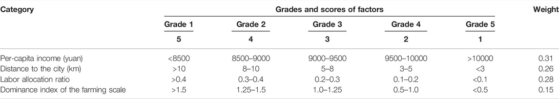
TABLE 3. Evaluation factor of farmland marginalization based on the opportunity cost.
2.5 The Total Value of Individual Evaluation Units
Combining the previously described evaluation system and using the integrated weighted model to calculate the total value of single evaluation units, we obtain Formula 5 as follows:
In Formula 5, Z is the total score of the evaluation units; n is the number of evaluation factors; Wk is the weight of evaluation factor k; and Vk is the quantified value of evaluation factor k.
The total value of each evaluation unit is calculated individually using the frequency histogram of the total score of the evaluation units. Using a natural breakpoint method, we divide the interval for the level of farmland marginalization under the perspective of each dimension.
2.6 Verification Based on Remote Sensing Images
The marginalization of farmland is the outcome of the interplay among multiple factors, such as natural suitability, farming conditions, and opportunity cost. To identify the main factors that contribute to farmland marginalization, this research formulates three weight allocation schemes based on land capacity-oriented, farming conditions-oriented, and opportunity cost-oriented perspectives. Then, the main factors that influence farmland marginalization are identified (e.g., Table 4).
TABLE 4. Weighted verification scheme based on different combinations.
First, using the Image Classification tool in ArcGIS10.2, we utilize the maximum likelihood classification to obtain remote sensing images of forested land in Mengjin County in 2017. Subsequently, we perform spatial superposition of the farmland in the current and forested areas obtained from remote sensing images, thereby obtaining the spatial distribution of the current farmland reforestation. Last, we analyze the evaluation outcomes of schemes with different orientations and their degree of fit with land reforestation.
3 Materials and Methods
3.1 Study Area
Mengjin County is located in the west of Henan Province in a transitional area of China’s second and third terrain steps on the southeast border of the Loess Plateau. Yanshi City and Gongyi City lie to the county’s east, Xin’an County to its west, Luolong District of Luoyang City to its south, and Jili District of Luoyang City, Jiyuan City, and Mengzhou City to its north, on the other side of the Yellow River (Figure 2). As a typical county in the middle and lower reaches of the Yellow River, Mengjin County has a unique geographical environment, and the evolution of cultivated land resources in the region is rapid. In the north of the county is Xiaolangdi Reservoir, a reservoir of the Yellow River. Since the dam was intercepted in 1997, the main channel of the Yellow River has been controlled in a fixed channel. In the northwest is the loess gully area, along the edge of Xiaolangdi Reservoir. In the south, the urban area of Luoyang is adjacent to the county. The traditional modes of development neglect the influence of cultivated land exploitation and utilization on regional ecological security and lead to instability in the area and quality of cultivated land, presenting concerns for food security. In the region, clarification of the main factors contributing to farmland marginalization is of significant importance for assuring local crop safety.
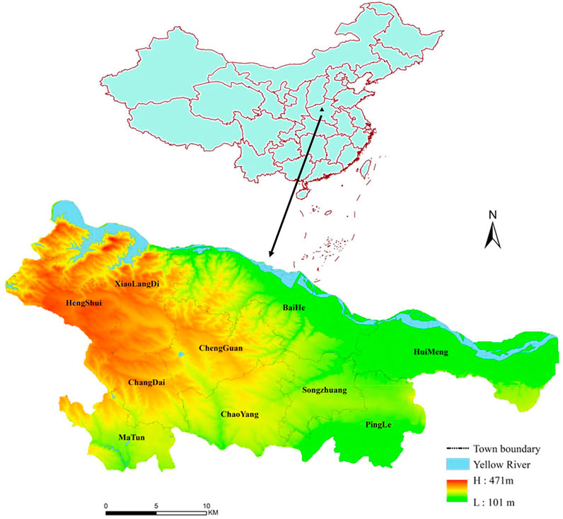
FIGURE 2. Map of mengjin county.
3.2 Data
The main sources of data used in this research are 1) statistical data, such as population and average population income, generally from the Mengjin County Statistical Yearbook (2018); 2) data on land utilization, which are based on the data from the Second National Land Survey of Mengjin County, which was updated in 2018 (1:5000); 3) remote sensing data from Google Earth (0.98*0.98 m); 4) soil data from Henan Province’s soil database (1:5000).
4 Results
4.1 The Natural Suitability of Cultivated Land
Based on natural breakpoints, the natural suitability of farmland throughout the county is divided into three intervals: high natural suitability (HNS), medium natural suitability (MNS), and low natural suitability (LNS).
As shown in Figure 3, farmland with HNS is distributed across Chaoyang, Songzhuang, the northern part of Pingle, and southwest of Huimeng. These areas have relatively flat terrains, the soil is mainly alluvial and cinnamon soil, and the soil layer is thick. Hence, most of these areas are considered ideal parcels with stable production. The total area of farmland with HNS is 189.00 km2, representing approximately 45.06% of the total farmland area. From the perspective of natural suitability, the risk of marginalization is low for this type of farmland. Farmland with MNS is mainly distributed along the southern part of Pingle, the northern part of Chengguan, central Hengshui, and southwest of Baihe, whereby the terrains are relatively inclined, and the soil is composed of calcareous cinnamon soil with high viscosity, thus posing certain limitations to farmland utilization. The farmland area with MNS totals 141.64 km2, representing approximately 33.77% of the total farmland area. From the perspective of natural suitability, the risk of farmland marginalization for this type of farmland is moderate. Farmland with LNS is mainly dispersed around Xiaolangdi, the northern part of Hengshui, and the Yellow River floodplain area in Huimeng. Farmland around Xiaolangdi and Hengshui has soil that is mainly composed of clay, and the topography poses immense limitations on them. Farmland in the northern part of Huimeng has soil that is mainly composed of silty sand, with severe leakage of moisture and fertilizer. The area of farmland with LNS is 88.81 km2, representing approximately 21.17% of the total farmland area. From the perspective of natural suitability, this type of farmland faces a higher risk of marginalization.
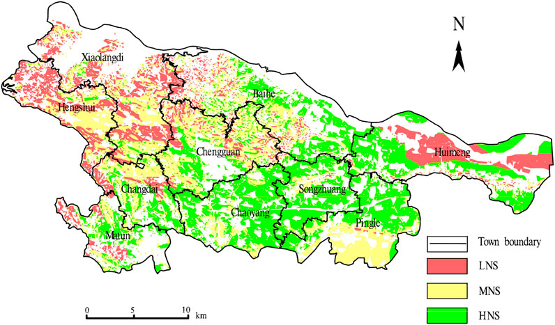
FIGURE 3. Map of spatial distribution of natural suitability of farmland in Mengjin County.
The natural suitability of farmland land is mainly based on soil and topographic elements, which are relatively stable and not easy to change. Based on the natural suitability, the higher risk of marginalization farmland in Mengjin is mostly cultivated land with large topographic relief, shallow soil and poor soil. These cultivated land have poor natural endowment and fragile ecology as a whole. With the acceleration of urbanization and industrialization, more non-agricultural employment opportunities have been created, and a large number of rural households have transferred to other places for employment, which has created social and economic conditions for returning farmland to forest and grass vegetation in LNS areas.
4.2 The Farming Conditions of Farmland
Using natural breakpoints, the farming conditions in the entire county can be divided into three intervals: highly convenient area (HCA), moderately convenient area (MCA), and inconvenient area (ICA).
As shown in Figure 4, the overall farming condition of the entire county is fragmented and spatially distributed in a scattered manner. Farmland with HCA is concentrated in Chaoyang, Songzhuang and Huimeng. These areas are characterized by flat terrain, large farmland parcels, high levels of centralization and contiguity, and the availability of comprehensive basic farming infrastructures. The total farmland area with HCA is 103.69 km2, representing approximately 24.72% of the entire farmland area. Having high and stable productivity, this type of farmland is less likely to be marginalized than are other types. Farmland with MCA is concentrated in Xiaolangdi, Hengshui, Chengguan, Matun, and the eastern part of Baihe. These areas are limited by the topography and have small farmland parcels and insufficient basic agricultural infrastructure. Consequently, they are not suitable for mechanized agriculture and large-scale farming. The size of the areas with MCA is 214.05 km2, representing approximately 51.03% of the total farmland area. From the perspective of farming conditions, this type of farmland faces a moderate risk of marginalization. Farmland with ICA is mainly located to the west of Xiaolangdi, to the west of Baihe, in the central and east parts of Chengguan, in the southern part of Matun, and north of Pingle. The topography has limited farmland most severely in Xiaolangdi and Baihe, which have highly fragmented farmland parcels and lack basic agriculture infrastructure. Farmland in Chengguan, Matun, and Pingle has highly fragmented parcels, a high rate of intersection between farmland and building zones, and small farmland parcels with irregular shapes due to urban diffusion. As such, it barely fulfills any requirement for large-scale farming. The total size of the farmland areas with ICA is 101.71 km2, which accounts for approximately 24.25% of the total farmland area. From the perspective of farming conditions, this type of farmland has a high risk of marginalization.
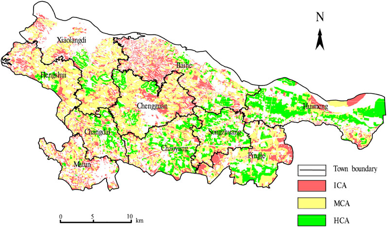
FIGURE 4. Map of the spatial distribution of farming conditions in Mengjin County.
The distribution of farmland in Mengjin is fragmented and sporadic, which includes not only poor connectivity and inconvenient cultivation caused by natural factors such as topography and landform cutting, but also inconvenient cultivation caused by human factors such as unreasonable layout of roads and drainage and irrigation systems, as well as ownership cutting caused by farmers’ contracting. Because the natural conditions of farmland are difficult to change, it is an important way to postpone the marginal utilization of farmland to improve the farmland with high natural suitability but not convenient cultivation.
4.3 The Opportunity Cost of Farmland Utilization
Using natural breakpoints, the opportunity cost of farming in the entire county is divided into three intervals: low opportunity cost (LOC), moderate opportunity cost (MOC), and high opportunity cost (HOC).
As shown in Figure 5, regions with HOC of farming are mainly dispersed around the southern part of Matun, the central and southern parts of Chaoyang, the southern part of Pingle, the central part of Chengguan, and the west of Baihe Town. These core regions of Mengjin County’s “Double Wing” program have numerous non-farming job opportunities and high per-capita income, but scattered farmland parcels and poor farming conditions. Consequently, farmers need to rely on transferring their farmland management rights to maximize their profitability. The total size of farmland with HOC is 119.32 km2, accounting for approximately 28.45% of the total farmland. From the perspective of opportunity cost, this type of farmland has a high risk of marginalization. Farmland with MOC is mainly distributed in Songzhuang, the north of Chaoyang, the northwest part of Chengguan, the north of Pingle, and the west of Huimeng. These regions are under the influence of urban radiation, and their farmland is centralized and contiguous and has superior farming conditions, making them well suited for large-scale farming. The total size of farmland with MOC is 164.57 km2, accounting for approximately 39.23% of the total farmland area. From the perspective of opportunity cost, this type of farmland faces a moderate risk of marginalization. Regions with LOC are mainly dispersed around Hengshui, Xiaolangdi and east of Huimeng. These regions are far from the city, the farmers have few non-farming job opportunities, the ratio of income from the agriculture sector is high, and the cultivation of farmland is highly valued by the farmers. The total size of farmland with LOC is 119.32 km2, accounting for approximately 28.45% of the total farmland area. From the perspective of opportunity cost, the risk of marginalization of this type of farmland is low.
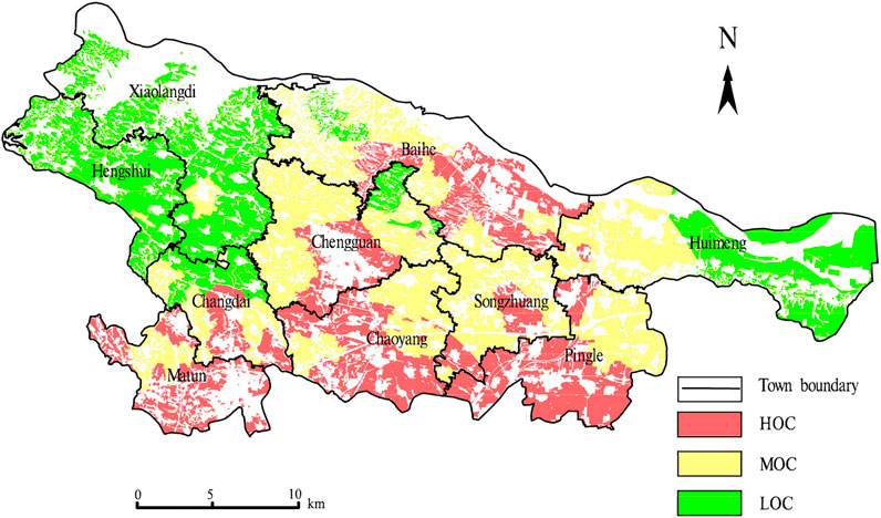
FIGURE 5. Map of the spatial distribution of opportunity cost of farming in Mengjin County.
In suburban areas, farmers can obtain higher economic benefits by adjusting their cultivated land to flowers, fruits and trees, etc. In addition, most of the farmers in this area have the expectation that their cultivated land will be occupied by construction, and arid farmland occupied the compensation price is low, therefore, Mengjin high opportunity costs less farmers give up farming.
The impact of opportunity cost on farmland marginalization varies with context, in contrast to conventional perception. Farmland with high opportunity cost is usually located in suburban areas with high levels of non-agricultural employment opportunities. In these areas, farmland usage tends towards floraculture, vegetable growing, sightseeing agriculture, and other agricultural practices. Furthermore, farmers living in suburban areas typically anticipate crop compensation in case of land expropriation. Both of these conditions induce farmers to fully utilize their farmland or to operate farming-related plantation/industries. Furthermore, farmers living in suburban areas typically anticipate crop compensation in case of land expropriation. Both of these conditions induce farmers to fully utilize their farmland or to operate farming-related plantation/industries.
4.4 Verification of Results
The interpretation of the results of the remote sensing images shows that, of the current 419.45 km2 of farmland throughout the county, the areas that have been reforested total 36.47 km2, which accounts for approximately 8.69% of the total farmland area. As shown in Table 5, there is a low degree of fit between the size of the reforested part of the farmland evaluated through a high, medium, and low risk of marginalization and an opportunity cost-oriented evaluation, of which farmland reforestation has been more strongly influenced by the natural suitability and farming conditions. In this case, farmers abandon their farmland as a rational choice to maximize their profit; therefore, farmland with poorer natural suitability is more likely to be abandoned. In addition, the increase in agriculture mechanization or capital investment is less likely to reduce the labor cost for farmland with inconvenient farming conditions. As such, when the labor cost continues to increase, this farmland is more likely to be abandoned.
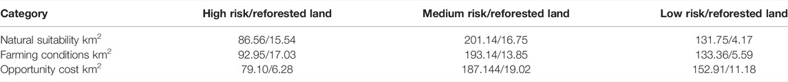
TABLE 5. Area distribution of reforested farmland under different evaluation dimensions.
5 Discussion
5.1 Large-Scale Grain Crop Cultivation is an Important Way to Reduce the Marginalization of Cultivated Land
With the advancement of urbanization in China and the increase in wages in non-farming sectors, the balance between labor allocation and farmland utilization has been disrupted. In addition, the disparity between grain price control and the rising costs of agricultural means of production, such as chemical fertilizers, seeds, and equipment, have reduced the average profit potential of farmland with low cultivation suitability. As a result, increasing numbers of rural laborers have transitioned into secondary and tertiary industries to maintain family income. Farmland parcels with poor land capacity and low profitability are the first to be marginalized. Although the abandonment of farmland is decided by farmers’ families, large-scale grain crop cultivation can also bring profits. Large-scale farmland transfer is regarded as the prerequisite for the development of modern agriculture or scaled-up agriculture production (Zou et al., 2019). If farmers are guided to conduct land transfer in an orderly manner, not only can their income be increased, but also the marginalization of cultivated land can be reduced. In most cases, it takes much more labor to grow non-food crops than food crops. Moreover, the average patch area of non-food cropland is small and the aggregation degree is low, which cannot produce economies of scale. Therefore, for the cultivated land planting non-food crops, we should improve the industrial layout planning, combined with the types of non-food crops, to guide the agglomeration effect of cash crops planting. Agricultural authorities should speed up the mechanization of farmland in hilly and mountainous areas, support the construction of grain processing facilities, extend the industrial chain, carry out large-scale and brand projects, and improve the efficiency of grain operation. In the future, we should strengthen the improvement of cultivated land with high natural suitability but medium and low cultivation conditions, appropriately merge land plots, cooperate with the popularization of small agricultural machinery, and create conditions for large-scale operation, so as to reduce the risk of marginal utilization of cultivated land.
5.2 There Is Little Difference in Farming Opportunity Cost at the County Level
The opportunity cost of labor force farming is an important factor affecting farmers’ land use decision-making. The gradient difference of economic development among the eastern, central and western regions of China is very significant, but the difference of economic development level within a county is not particularly significant. Therefore, the difference in the opportunity cost of farming has a relatively small impact on the abandonment of cultivated land within the county, but the impact of opportunity cost of cultivated land will be particularly large if it is compared on a national scale. The evaluation result of opportunity cost of farming selected in this paper is a relative value, which can only reflect the relative difference within Mengjin, As farmers move in a comprehensive range, more in-depth studies are needed to select the evaluation index of opportunity cost of farmland utilization.
5.3 Withdrawal of Inferior Cultivated Land From Cultivation is Beneficial to Ecological Restoration
The goal of the DBTFA policy is to guarantee national food security. Over the more than 30 years of implementation of this policy, the stability of the cultivated land area has been maintained, but the utilization of cultivated land has lacked effective management. In China, most land suitable for reclamation has been reclaimed. Presently, the land that can be developed into arable land is mainly ecologically fragile land, such as barren mountain or beach areas with poor soil quality and challenging conditions for cultivation. The improper development and utilization of land can easily cause ecological problems. In addition, there is a high risk that cultivated land with poor conditions will be abandoned due to economic considerations.
In the past period, the relevant national authorities lacked a systematic understanding of ecological civilization construction, and took improving forest coverage rate as the policy focus to promote ecological civilization construction. Under the guidance of relevant policies, large-scale land space greening projects have been carried out on both sides of highways, which to some extent promotes the “non-grain” conversion of cultivated land. At present, the work of national spatial planning in various regions should reflect the requirements of national spatial development strategy, coordinate the relationship between food security, ecological civilization and sustainable development, take the same national spatial management and control concept as the work direction, reasonably delimit ecological space, urban construction space and agricultural development space, and optimize the management and control mode of spatial resources.
From the perspective of ecological restoration, the removal of poor-quality farmland from farming will support the recovery of a regionally weakened ecology. At the same time, such a removal can provide the space required to nurture biodiversity. However, from the perspective of food safety, the intensifying marginalization of farmland may threaten the region’s food safety. Therefore, further study is required to understand the developmental pattern of farmland marginalization and its influencing factors to formulate more rational and effective regulatory policies.
6 Conclusion
1) Soil, slope and other natural factors in the evaluation index of natural suitability of cultivated land are stable and not easy to change. Natural suitability is the basic condition that affects the marginal utilization of cultivated land. Interconnectivity of roads on the farmland, Parcel contiguity, irrigation condition index and the moderating effect of terrain factors, such as natural suitability and cultivation convenience has certain spatial correlation, but, in the spatial distribution of the natural suitability is not entirely agree with farming convenience degree. For example, the farmland soil quality is relatively poor in the yellow river beach, but flat belt land, Road accessibility and cultivated land contiguity are high, so the risk of marginal use of cultivated land in beach area is low.
2) From the verification results of remote sensing images, it can be seen that poor natural suitability and inconvenient farming conditions are the main influencing factors of cultivated land marginalization in Mengjin County, which is also a high-risk area of cultivated land marginalization utilization. Due to the poor natural suitability and inconvenient farming conditions of the region, its food production capacity and ecological environment conditions are relatively poor. As a result, the natural suitability poor tillage and inconvenience of cultivated land adjustment back to forest land, help regional fragile ecological restoration, the impact on the food security is also very limited.
3) The areas with high opportunity cost of cultivation are mostly in the urban suburbs, while the suburban areas are also relatively concentrated areas with high quality cultivated land, and the non-grain utilization of regional cultivated land is relatively common. From the actual situation of Mengjin, the abandoned land utilization in the areas with high opportunity cost cultivation is less. Because through the adjustment of industrial structure also can get high profits, This is also related to the relatively small differences in opportunity costs of farming within counties.
4) The research method in this paper is a basic method to reflect the evolution law of cultivated land marginalization, but it will show inadequate adaptability for areas with special phenomena. For example, when identifying the leading factors of cultivated land marginalization, only conversion of cultivated land to forest land is used as a reference, which also leads to the inability to give a reasonable explanation for typical situations. For example, in some areas, farmers are forced to plant trees in cultivated land in order to improve the landscape effect. If there are a large number of landscape trees in a place, the applicability of such research methods would appear unconvincing (Wang and Hou, 2021).
Data Availability Statement
The original contributions presented in the study are included in the article/supplementary material, further inquiries can be directed to the corresponding author.
Author Contributions
In this paper, XG processed the data and wrote the main contents of the paper. XW and WC provided ideas for the paper. All the authors discussed the results and implications and commented on the manuscript at various stages.
Funding
This work was supported by the Humanities and Social Science Project of Ministry of Education (Grant No. 20YJCZH037), Henan Provincial Key Young Teachers project (Grant No. 2019GGJS134) and Henan Provincial Scientific and Technological Innovation Talents Support Program (Grant No. 2021-CX-052).
Conflict of Interest
The authors declare that the research was conducted in the absence of any commercial or financial relationships that could be construed as a potential conflict of interest.
Publisher’s Note
All claims expressed in this article are solely those of the authors and do not necessarily represent those of their affiliated organizations, or those of the publisher, the editors and the reviewers. Any product that may be evaluated in this article, or claim that may be made by its manufacturer, is not guaranteed or endorsed by the publisher.
References
Aide, T. M., and Grau, H. R. (2004). Globalization, Migration, and Latin American Ecosystems. Science 305, 1915–1916. doi:10.1126/science.1103179
Alcantara, C., Kuemmerle, T., Prishchepov, A., and Radeloff, V. (2012). Mapping Abandoned Agriculture with Multi- Temporal MODIS Satellite Data. Remote Sens. Environ. 124, 334–347. doi:10.1016/j.rse.2012.05.019
Baumann, M., Kuemmerle, T., and Elbakidze, M. (2011). Patterns and Drivers of Post-socialist Farmland Abandonment in Western Ukraine. Land Use Policy 28, 552–562. doi:10.1016/j.landusepol.2010.11.003
Edward, B., Joanne, C., and Alan, G. (2010). The Forest Transition: Towards a More Comprehensive Theoretical Framework. Land Use Policy 27, 98–107. doi:10.1016/j.landusepol.2009.02.001
Li, M. (2019). The Effect of Land Use Regulations on Farmland Protection and Non-agricultural Land Conversions in China. Aust. J. Agric. Resour. Econ. 63, 643–667. doi:10.1111/1467-8489.12311
Li, S., Li, X., Xin, L., Tan, M., Wang, R., et al. (2017). Extent and Distribution of Cropland Abandonment in Chinese Mountainous Areas. Resour. Sci. 10, 1801–1811. (in Chinese). doi:10.18402/resci.2017.10.01
Li, S., and Li, X. (2016). Progress and Prospect on Farmland Abandonment [J]. Acta Geogr. Sin. 71 (3), 370–389. (in Chinese). doi:10.11821/dlxb201603002
Li, S., and Li, X. (2017). Global Understanding of Farmland Abandonment: A Review and Prospects. J. Geogr. Sci. 27, 1123–1150. doi:10.1007/s11442-017-1426-0
Li, S., and Li, X. (2019). The Mechanism of Farmland Marginalization in Chinese Mountainous Areas: Evidence from Cost and Return Changes. J. Geogr. Sci. 29, 531–548. doi:10.1007/s11442-019-1613-2
Li, X., and Zhao, Y. L. (2011). Forest Transition, Agricultural Land Marginalization and Ecological Restoration. China Popul. Resour. Environ. 10, 91–95. (in Chinese). doi:10.3969/j.issn.1002-2104.2011.10.014
Liu, L., Zhou, D., Chang, X., and Lin, Z. (2020). A New Grading System for Evaluating China's Cultivated Land Quality. Land Degrad. Dev. 31, 1482–1501. doi:10.1002/ldr.3547
Lu, X., Zhang, Y., and Zou, Y. (2021). Evaluation the Effect of Cultivated Land Protection Policies Based on the Cloud Model: A Case Study of Xingning, China. Ecol. Indic. 131, 108247. doi:10.1016/j.ecolind.2021.108247
Romero-Calcerrada, R., and Perry, G. L. W. (2004). The role of land abandonment in landscape dynamics in the SPA 'Encinares del rı́o Alberche y Cofio, Central Spain, 1984-1999. Landsc. Urban Plan. 66, 217–232. doi:10.1016/s0169-2046(03)00112-9
Rudel, T. K., Coomes, O. T., Moran, E., Achard, F., Angelsen, A., Xu, J., et al. (2005). Forest Transitions: towards a Global Understanding of Land Use Change. Glob. Environ. Change 15, 23–31. doi:10.1016/j.gloenvcha.2004.11.001
Ruskule, A., Nikodemus, O., Kasparinskis, R., Bell, S., and Urtane, I. (2013). The Perception of Abandoned Farmland by Local People and Experts: Landscape Value and Perspectives on Future Land Use. Landsc. Urban Plan. 115, 49–61. doi:10.1016/j.landurbplan.2013.03.012
Sayadi, S., González-Roa, M. C., and Calatrava-Requena, J. (2009). Public Preferences for Landscape Features: The Case of Agricultural Landscape in Mountainous Mediterranean Areas. Land Use Policy 26, 334–344. doi:10.1016/j.landusepol.2008.04.003
Shao, J. a., Zhang, S., and Li, X. (2015). Farmland Marginalization in the Mountainous Areas: Characteristics, Influencing Factors and Policy Implications. J. Geogr. Sci. 25, 701–722. doi:10.1007/s11442-015-1197-4
Shi, T., Li, X., and Xin, L. (2016). Analysis of Farmland Abandonment at Parcel Level: A Case Study in the Mountainous Area of China. Sustainability 8, 1–19. doi:10.3390/su8100988
Sklenicka, P., Janovska, V., Salek, M., Vlasak, J., and Molnarova, K. (2014). The Farmland Rental Paradox: Extreme Land Ownership Fragmentation as a New Form of Land Degradation. Land Use Policy 38, 587–593. doi:10.1016/j.landusepol.2014.01.006
Strijker, D. (2005). Marginal Lands in Europe-Causes of Decline. Basic Appl. Ecol. 6, 99–106. doi:10.1016/j.baae.2005.01.001
Su, Y., Qian, K., Lin, L., Wang, K., Guan, T., and Gan, M. (2020). Identifying the Driving Forces of Non-grain Production Expansion in Rural China and its Implications for Policies on Cultivated Land Protection. Land Use Policy 92, 104435. doi:10.1016/j.landusepol.2019.104435
Terres, J.-M., Scacchiafichi, L. N., Wania, A., Ambar, M., Anguiano, E., Buckwell, A., et al. (2015). Farmland Abandonment in Europe: Identification of Drivers and Indicators, and Development of a Composite Indicator of Risk. Land Use Policy 49, 20–34. doi:10.1016/j.landusepol.2015.06.009
Wang, G., and Hou, S. (2021). Ensuring China’s Food Security in the Global COVID-19 Crisis: Contradictions and Resolutions. J. Xinjiang Normal Univ. (Philosophy Soc. Sci. 42 (1), 120–133. (in Chinese). doi:10.14100/j.cnki.65-1039/g4.20200722.001
Wu, S., Yu, H., and Chu, Y. (2019). Limitation and Breakthroughs in the Study of “Non Grain” in Cultivated Land under Agricultural Scale Management [J]. J. Northwest A&F Univ. Soc. Sci. Ed. 19 (3), 142–151. (in Chinese). doi:10.13968/j.cnki.1009-9107.2019.03.17
Xin, L., Li Xiu, B., Tan, M., and Hao, H. (2011). The Rise of Ordinary Labor Wage and its Effect on Agricultural Land Use in Present China. Geogr. Res. 8, 1391–1400. doi:10.11821/yj2011080005
Xue, X., and Zhang, Y. (2017). Current Situation, Causes and Countermeasures Regarding Non-grain Growing of Farmland in Major Grain-Producing Counties [J]. Acad. J. Zhongzhou 8, 40–45. (in Chinese). doi:10.3969/j.issn.1003-0751.2017.08.008
Yan, J., Yang, Z., Li, Z., Li, X., Xin, L., and Sun, L. (2016). Drivers of Cropland Abandonment in Mountainous Areas: A Household Decision Model on Farming Scale in Southwest China. Land Use Policy 57, 459–469. doi:10.1016/j.landusepol.2016.06.014
Yang, Q., and Zhang, D. (2021). The Influence of Agricultural Industrial Policy on Non-grain Production of Cultivated Land: A Case Study of the "one Village, One Product" Strategy Implemented in Guanzhong Plain of China. Land Use Policy 108, 105579. doi:10.1016/j.landusepol.2021.105579
Zhang, O. (2016). Research on Countermeasures of Preventing Circulation-Land "Non-grain" under the Perspective of Peasant Households Differentiation[J]. Acad. J. Zhongzhou 4, 49–54. (in Chinese). doi:10.3969/j.issn.1003-0751.2016.04.010
Zhang, Y., Li, X., and Song, W. (2014). Determinants of Cropland Abandonment at the Parcel, Household and Village Levels in Mountain Areas of China: A Multi-Level Analysis. Land Use Policy 41, 186–192. doi:10.1016/j.landusepol.2014.05.011
Zhou, Y., Li, X., and Liu, Y. (2021). Cultivated Land Protection and Rational Use in China. Land use policy 106, 105454. doi:10.1016/j.landusepol.2021.105454
Keywords: farmland, marginalization, natural suitability, farming conditions, opportunity cost
Citation: Guan X, Wang X and Chen W (2022) Risk Assessment and Regulation Strategy of Farmland Marginalization: A Case Study of Mengjin County, Henan Province. Front. Environ. Sci. 10:892665. doi: 10.3389/fenvs.2022.892665
Received: 09 March 2022; Accepted: 23 June 2022;
Published: 12 July 2022.
Edited by:
Wenqiu Ma, China Agricultural University, ChinaReviewed by:
Liu Yu, Beijing Research Center for Information Technology in Agriculture, ChinaWenping Liu, Huazhong Agricultural University, China
Copyright © 2022 Guan, Wang and Chen. This is an open-access article distributed under the terms of the Creative Commons Attribution License (CC BY). The use, distribution or reproduction in other forums is permitted, provided the original author(s) and the copyright owner(s) are credited and that the original publication in this journal is cited, in accordance with accepted academic practice. No use, distribution or reproduction is permitted which does not comply with these terms.
*Correspondence: Xiaoke Guan, Z3VhbjEwMTRAMTYzLmNvbQ==