 Owen Fenton
 Paul Rice1
 John. G. Murnane
 Patrick Tuohy
- 1Environmental Research Centre, Teagasc Johnstown Castle Co., Wexford, Ireland
- 2School of Engineering, University of Limerick, Limerick, Ireland;
- 3Animal and Grassland Research and Innovation Centre, Teagasc Moorepark ,Cork, Ireland
Internal farm roadways are connectors within agricultural landscapes, which act as sub-components of the nutrient transfer continuum (NTC). On dairy farms, roadway surface runoff dissolved and particulate phosphorus (P) sources stem from a combination of cow excreta deposited at locations that impede animal flow, soil deposited from cow hooves or machinery tyres, run-on from up-gradient fields, public roadways or farmyards and incidental spill of organic/inorganic fertilizers. The present study investigates the storage and potential release of P from the underlying roadway material (i.e. composite of soil and stone aggregates) as this source component is not considered in the NTC framework or documented in the literature. Herein, farm roadway materials were sampled (to 1 cm depth) at 17 locations avoiding fresh cow excreta. Multiple location types were selected e.g. straight roadway sections, roadway junctions, before and adjacent standoff areas associated with cattle underpasses, with all locations varying in distance from the farmyard. Roadway samples were analysed for phosphorus (P) and metals (Al, B, Ca, Co, Cu, Fe, K, Mg, and Mn) content. Results showed that the soil component of roadway materials are significant P legacy sources and are in themselves a P-storage component that merits inclusion in the NTC framework. All sampled locations, when compared with fresh roadway stone aggregates or surrounding fields, had highly elevated P with plant available Morgans P > 8 mg L-1 (Index 4, ranging from 10 – 110 mg L-1). Sampling points within 100 m of the farmyard together with roadway junctions and underpasses beyond this distance had highest P concentrations. Critical source areas, where source, mobilisation and transport of P to waters coincided, formed at three locations. Possible mitigation measures are a) divert roadway runoff into fields using low-cost surface water breaks, b) disconnect cattle underpass tanks from receiving waters and c) change roadway infrastructure to improve cow flow and minimise source build-up. Future research should examine P loads in runoff from roadway sections across farm typologies and roadway material types.
1 Introduction
The impairment of fresh waters due to phosphorus (P) and nitrogen (N) emissions from agricultural landscapes remains a key environmental issue (Fenton et al., 2019). Nutrient losses from agricultural landscapes are an aggregate of a number of source and transport interactions (Reid et al., 2018; Harrison et al., 2019). Runoff from roadways and ditches impact on water quality at catchment scale. These areas are described as spatially distributed nonpoint sources by Buchanan et al. (2013). Farm roadways and tracks are defined as “semi-pervious areas” by Srinivasan and McDowell (2009), which contribute significant nutrient losses at catchment scale when connected to waters. Their impact is distinct from other diffuse losses (e.g. from fields) during dry seasons when below average rainfall occurs. These semi pervious areas also represent active subsurface pathways of loss and given the amount of time animals spend on these surfaces load losses are significant at catchment scale along both surface and subsurface pathways (Monaghan and Smith, 2012).
Recently, a nutrient transfer continuum (NTC) framework was applied to farmyards by Vero and Doody (2021). Only when information and knowledge on nutrient sources, mobilisation, delivery and impact are gathered, can the correct mitigation options for farmyard N and P losses be identified (Vero and Doody, 2021). Dairy farm roadways are also a sub-component of the NTC and a similar conceptualisation exercise is needed to apply the NTC framework to P and N losses from dairy farm roadways to watercourses to establish their significance within the continuum. In a recent review of farm roadway runoff (RR), the source component was identified (faeces, urine, run-on from fields, roadways and farmyards) and its nutrient (N and P) and pathogen profile was equated to that of dilute slurry or dairy soiled water (Fenton et al., 2021). In the European Union (EU), the Nitrates Directive (European Council, 2000), is a principle legislative instrument designed to protect water quality through reducing the input of agriculturally-derived nutrients into waters and to promote the adaptation of good farming practices, through programmes of measures. In recent iterations of the Nitrates Directive (S.I. No. 605 of 2017) in Ireland, the risk of potential pollution from farm roadways is acknowledged and mitigation is legislated for by a stipulation that decrees “There shall be no direct runoff of soiled water from farm roadways to waters from 1 January 2021’’. Roadway research on dairy farms has focused on characterisation of fresh cow deposits (faeces and urine) (Monaghan and Smith, 2012; McDowell et al., 2020); however to date, no information is available on nutrient storage, specifically P, within the roadway materials and this source has not been considered as a component of the NTC. A roadway section receives deposits at different locations over time and therefore during rainfall all areas that contribute a source to an eventual runoff delivery point need consideration. As the milking routine of standard twice a day milking, sees each paddock of the grazing area grazed in rotation (Dillon et al., 1995); this typically (occasionally different paddocks are grazed in the morning and evening) necessitates that a given farm roadway is used 4 times in a 24 hr period between the grazing area and the milking parlour. Cow behaviour dictates that as cow movement becomes impeded or slowed, an opportunity arises for them to increase excretions (Fenton et al., 2021). This, in turn results in some roadway sections becoming more heavily soiled relative to other roadway sections where excretions occur only sporadically. In separate studies which documented the P content of deposits and examine subsequent load losses of P in runoff on dairy farms, Monaghan and Smith, 2012 and McDowell et al. (2020) found that P load losses varied spatially and temporarily but were highest within the first 100 m of the farmyard and dissipated with increasing distance away from the farmyard. In terms of identifying connectivity of RR to waters (directly or indirectly) on dairy farms, a collection of visual indicators map delivery points (i.e. the point at which runoff enters a watercourse) and sections of roadway where sources are likely to be large due to cow flow issues (Teagasc, 2017). The presence of open ditches that discharge directly to waters and zones within 100 m of farmyards have been classified as high risk (Moloney et al., 2020). Therefore, any roadways that are connected directly/indirectly to open ditches (i.e. waters) within 100 m of a farmyard need to be identified and investigated as potential critical source areas (CSAs).
Common agricultural soil tests have previously identified legacy P hotspots in drainage ditch sediments (Daly et al., 2017; Mattila and Ezzati, 2021). In Ireland, the P index (Wall and Plunket, 2021) system is the basis from which fertiliser P recommendations for grassland and other crops are made. The soil P index depends on the level of available P for plant growth and is determined by measuring the amount of P that is extracted by Morgan’s solution. The target index for P in grassland soils is Index 3 (Morgan’s P 5.1 to 8.0 mg L-1). Soils at P Index 4 (Soil P > 8.0 mg L-1) have excess available P and can pose a risk of nutrient losses in runoff. The Morgan’s P test, as an indicator of available P, examines roadway materials as a P source, where values exceeding 8.0 mg L-1 would indicate elevated P concentrations.
The objective of this field study was to identify runoff mitigation options for farm roadways by applying the NTC to the roadway network on an intensive dairy farm in south-east Ireland. To meet this objective, this study measured the available P concentrations in farm roadway surface material and identified locations where high P source coincided with hydrological connectivity on the farm.
2 Materials and methods
2.1 Study site
The research was conducted on the dairy farm at Johnstown Castle Research Centre in southeast Ireland (52˚17’30” N, 6˚29’50” W). The dairy herd comprises 140 Holstein Friesian cows, farmed on a grazing area of 70 ha. The site receives an annual average mean precipitation of 1100 mm. Soil drainage classes on site range from excessively to poorly drained. Artificially drained fields comprise groundwater drainage systems at depths of approx. 1 m discharging to a second order stream (Ezzati et al., 2020), which is piped for a section of the farm. While there is no surface runoff from fields to this stream (Kurz et al., 2005), there is direct connectivity between the stream, open ditches, the farmyard and the farm roadway network (3.4 km in total) (Figure 1, Table 1). There are two cattle underpasses under public roadways and these provide connectivity and delivery of nutrients from underpasses to waters (both surface and groundwater) if tanks are not maintained (Figure 2). A detailed description of the surface and sub-surface drainage system network installed on the farm and its connectivity and impact on a second order stream is available in Clagnan et al. (2019) and Ezzati et al. (2020).
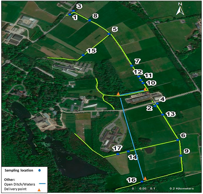
FIGURE 1. Roadway network and sampling locations.
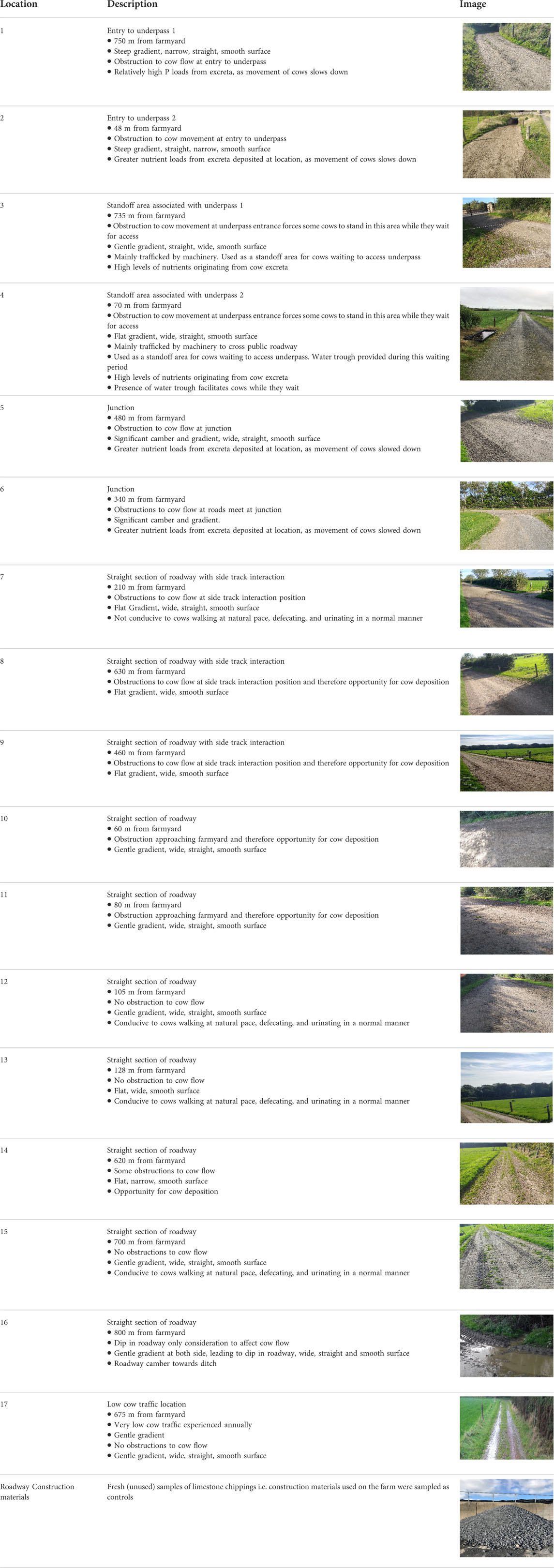
TABLE 1. General descriptions of sampling locations.
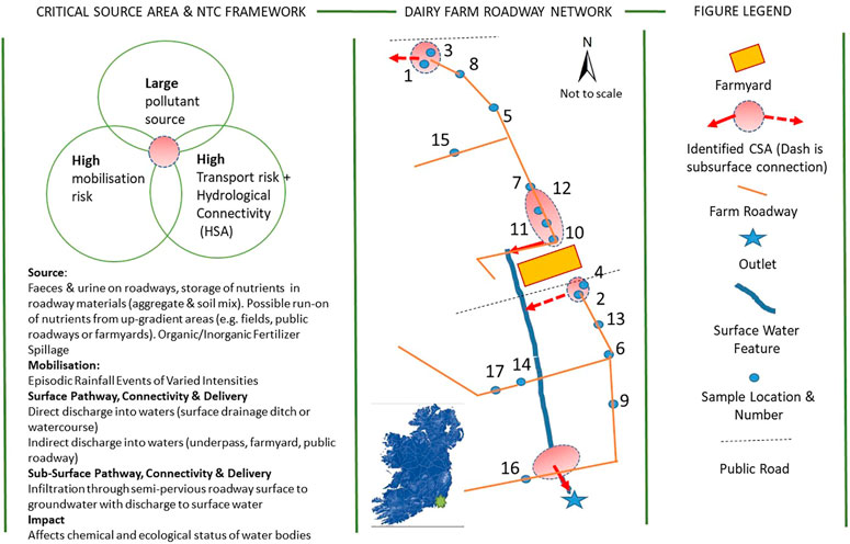
FIGURE 2. Roadway network and sampling locations with associated critical source areas (CSA's) and nutrient transfer continuum (NTC) framework.
2.2 Sampling and analyses
Roadway material was bulk sampled at 17 locations that incorporated a variety of roadway characteristics and associated cow movement in September and October (Figure 1, Table 1). This time of year marks the beginning of the housing season (i.e. closed period) on dairy farms in Ireland. The housing season ends in late January and therefore direct deposition of organic waste diminishes on roadway networks but leaves the roadway materials exposed (and nutrients stored therein) to the hydrologically active period of the year. The distance from the farmyard (Table 1) of each individual location along the extent of farm roadway as outlined in Figure 1, was measured in GIS (ArcGIS; Esri, 2020) and mapping was carried out using digitisation at a scale of 1:3000.
Each location was sampled outside of milking times by walking in a zig-zag pattern and extracting roadway at regular intervals to 1 cm depth using a hand held corer (avoiding fresh urine and faeces where present, ∼10 samples). The samples from each location were composited and transported to the soil laboratory. Previously unused roadway construction materials, which were stockpiled on the farm, were also sampled and analysed for comparative purposes. All samples were oven dried (40 °C), passed through a 2 mm sieve, and stored at room temperature prior to analysis. Soil pH was determined using a 1:2.5 soil-to-water ratio (Bryne, 1979).
Two-gram samples were shaken on a reciprocating shaker for 5 min and the supernatant was filtered (0.45 µm) and tested for Mehlich 3-P (M3-P), aluminium (Al), iron (Fe), calcium (Ca), boron (B), cobalt (Co), copper (Cu), potassium (K), magnesium (Mg), manganese (Mn), sodium (Na), sulphur (S) and zinc (Zn) using a soil solution ratio of 1:10 in Mehlich 3 reagent (0.2 M CH3COOH + 0.25MNH4NO3 + 0.015 M NH4F + 0.13 M HNO3 + 0.001 M EDTA. Plant available P (Pm) and K (Km) were determined by Morgan analyses (extraction in 1:5 v/v in 0.5 M sodium acetate + 0.5 M acetic acid; pH 4.8, shaken for 30 min and analysed coluorimetrically) (Morgan 1941).
3 Results and discussion
3.1 Location based results
The unused road surface stone aggregate showed high mean pH (8.76) and high Ca content (∼40,000 mg kg-1) indicative of limestone geology. All metal concentrations were very low to negligible. Phosphorus concentrations in the unused road surface stone aggregate (See photo in Table 1) were insignificant (mean Morgan’s P 0.77 mg L-1). These materials did not introduce a P source when used in the making of the internal roadways.
From visual observations, roadway surface materials are an agglomeration of stone aggregate, soil from cow hooves and machinery, organic material from cow faeces and urine and a tiny fraction from organic or inorganic fertilizer that may spill onto the surface from farm activities. The focus here is on the composite roadway material and not fresh deposits on top of the roadway. Results show that P concentrations for all sampling locations were comparable for both time points September (Table 2), October (Table 2). The high P concentrations were consistent with repeated deposition of sources over time leading to an accumulation of significant amounts of available and labile P. Values of Morgan P ranged from 9.54 to 110 mg P L-1, and Mehlich 3 extractable P values followed a similar pattern with values ranging from 25.09 to 319.26 mg P kg-1. Both tests measure plant available P in soil for agronomic fertiliser recommendation and the values recorded along the road network exceeded the agri-environmental thresholds for soil. Morgan’s P values above 8 mg L-1, and Mehlich 3 P values above 75 mg kg-1, indicate a source risk of P loss from soil (Dunne et al., 2021a), however the values recorded along the roadway network in this study were up to 10 times higher than the agri-environmental thresholds for soils (Wall and Plunket, 2021), and represent a significant source of soluble and available P that could connect to a pathway. This source merits inclusion in the NTC framework. Dunne et al.,(2021a) derived a modified P Index for soil using Morgan P and created a P saturated category that identified soils that have received excessive P applications over time. All of the sample points along the road network in this study fall into the P saturated class in Dunne et al.,(2021a) and represent a significant P loss risk if connected to a pathway.
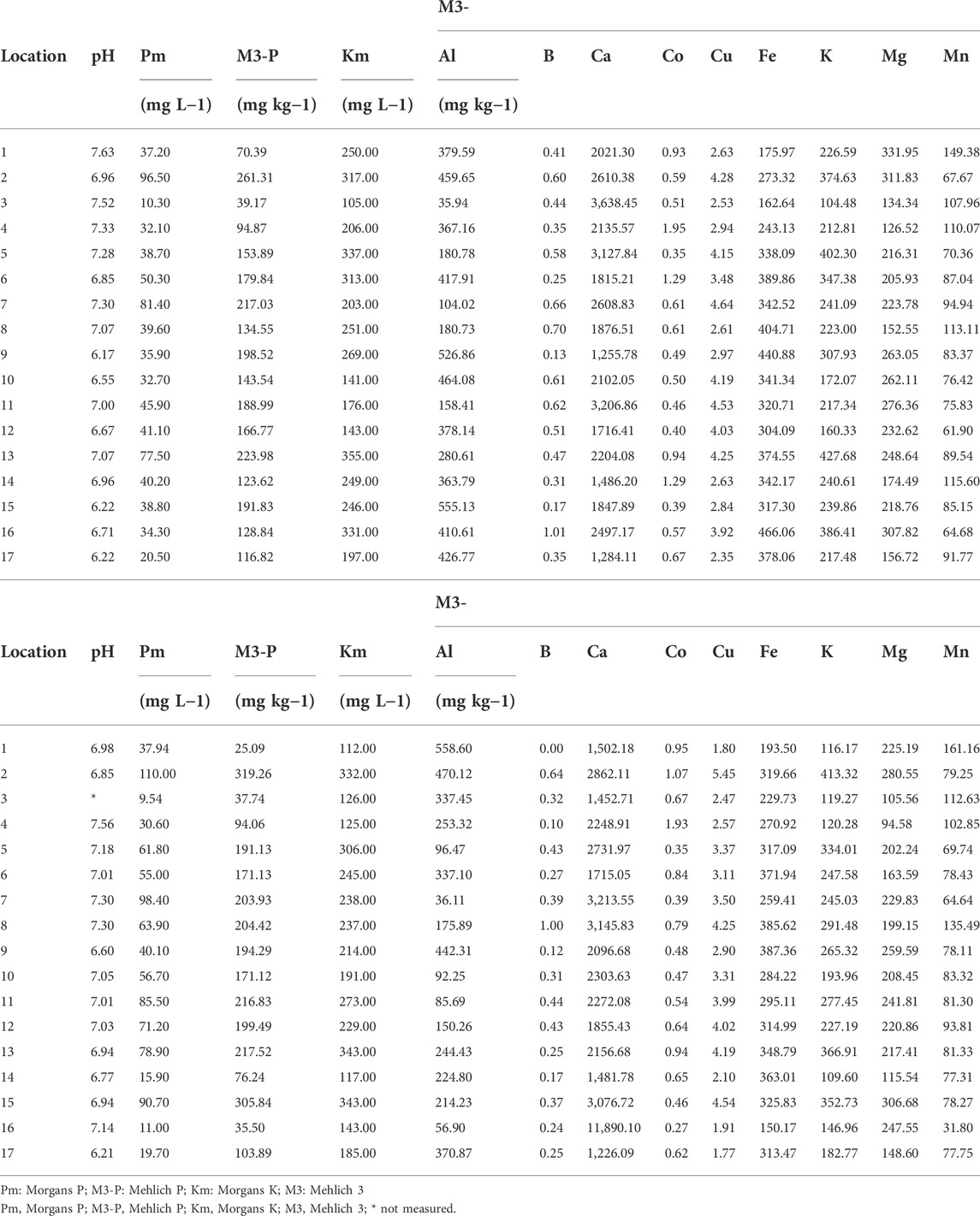
TABLE 2. Chemical properties of roadway samples collected on September 2021 (Panel A). Chemical properties of roadway samples collected on October 2021 (panel B).
The pH of samples taken along the road network were moderately alkaline in nature, ranging from 6.2 to 7.6, possibly due to the limestone nature of the stone aggregate used to surface the network. Mehlich 3 extractable metals such as Al, Fe were lower than those measured in Irish agricultural soils and associated with P sorption (Dunne et al., 2021b), leaving little scope for any binding or sorption of P by the material. Mehlich 3 extracts of metals such as Cu and Zn along the network were in line with those reported in the literature for cattle slurry (Provolo et al., 2018) and there was no evidence of heavy or trace metal accumulation in samples taken along the roadway network.
3.2 NTC framework
Table 3 presents results of the entire farm roadway network indicating elevated P concentrations regardless of location, cow flow conditions or proximity to the farmyard. This shows that the entire network is a P store, which merits inclusion in the NTC framework. This has implications for management of roadway networks during both open (cows are outside and not housed) and closed (housed during hydrologically active period) periods as the source of P on the roadway network is present throughout the year. The nutrient (P and N) transfer continuum framework (Haygarth et al., 2005) links source to impact on agricultural landscapes and was used by Wall et al. (2011) and Shore et al. (2014a) to examine nutrient source and impact while assessing national action programmes at meso-catchment scale. To apply the continuum to dairy farm roadways, information on source-mobilisation-transport and hydrological connectivity-delivery and impact must be conceptualised and collated. A delivery point or area is where runoff enters waters. This approach has been applied at sub-catchment scale to nutrient losses and impact from farmyards (Vero and Doody, 2021) and drainage ditch networks to waters (Moloney et al., 2020).
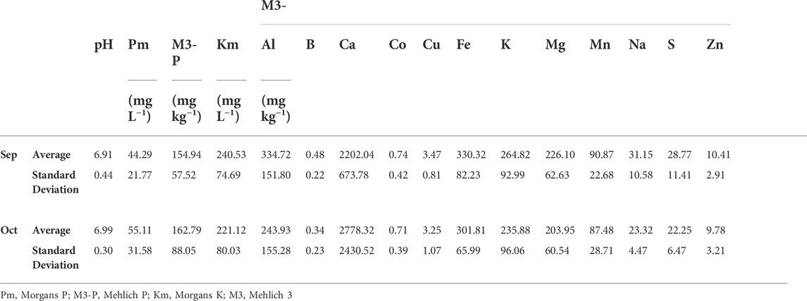
TABLE 3. Whole farm average concentrations for all roadway sampling locations across the two sampling occasions.
The following information applies to farm roadways (Figure 2):
• P sources (dissolved and particulate fractions) originate from cow faeces and urine deposited on roadway surfaces (Fenton et al., 2021), P in soil becomes incorporated around stone aggregates from animal hooves and machinery. Limited amounts of organic and inorganic fertilizer from farm activities may fall on these surfaces. In some cases run-on will move nutrients from higher elevated areas to the roadway network e.g. from fields or public roadways or farmyards (Fenton et al., 2021). Phosphorus originating from these composite sources/deposits becomes stored and are available for release as legacy P sources from roadway materials (present study) during rainfall. High P-concentration is likely because slow downward mobility of P is expected to occur in the roadway materials (due to the influence of highly compacted roadway material, alkaline pH and limestone content).
• Mobilisation occurs during precipitation (dominated by rainfall and dependent on timing, magnitude and intensity) (Fenton et al., 2021).
• Transport is controlled by connectivity of the roadways to waters (directly into open drainage ditches or a surface water body or indirectly into public roadways, farmyards and underpasses (can be connected to surface or groundwater) (Fenton et al., 2021; present study)). Subsurface leached losses to groundwater from these semi pervious areas have also been documented (Srinivasan and McDowell, 2009).
• The loss of nutrients to water bodies can negatively affect the chemical and ecological status of waters, with significant impact distinct from other sources at catchment scale occurring during summer months of the year (Srinivasan and McDowell, 2009; Monaghan and Smith, 2012). In rivers, N and particularly P loss can result in excessive plant and algal growth. This growth and decay cycle reduces the amount of oxygen in the river and suffocates sensitive fauna. Excessive fine sediment in a river can smother the streambed habitat and clog the gills of many sensitive mayfly species. From a human health perspective, bacterial contamination of watercourses is a significant issue, particularly in the context of drinking water and bathing water quality. To safeguard impact, soiled farm roadway runoff must be prevented from directly or indirectly entering waters (Teagasc, 2017).
• To break connectivity before delivery of RR to waters, mitigation measures include those mentioned in Fenton et al. (2021), which include a mixture of cow management (e.g. increase cow flow) and on-off roadway options e.g. low cost water diversion bars and roadway camber adjustments. The mitigation measure deployed should also consider managing the P source.
3.3 Critical Source Area and mitigation
Farm roadways can provide connectivity at delivery points within diffuse CSAs. However, in the absence of breakthrough points the roadway itself becomes a CSA. The source is present on the roadway surface and in the roadway materials, the transport potential is high, after rainfall mobilisation of overland flow begins on the roadway surface due to the physical characteristics of the roadway (Fenton et al., 2021), which if connected to waters through a delivery point has an impact on water quality. In reality, many locations along a roadway combine to form a potential CSA where a source of pollutants coincides with an area of high mobilisation and hydrologically sensitive areas (HSAs) that have the highest propensity for generating surface runoff and transporting pollutants (Thomas et al., 2016). Identification of CSAs and delivery points to waters on roadways for the present study was conducted visually for each of the locations (Table 4).
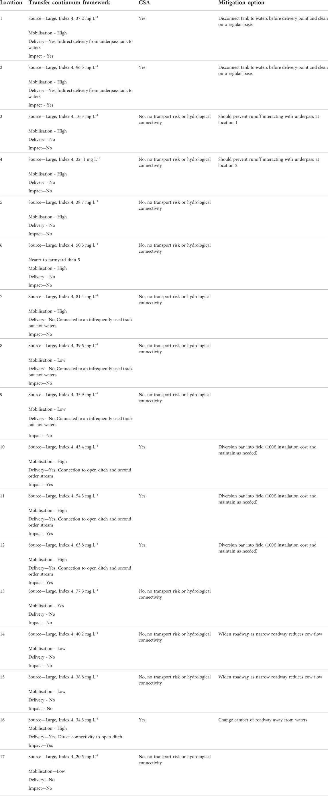
TABLE 4. Phosphorus component of Nutrient Transfer Continuum Framework for each location, Critical Source Area (CSA) and Mitigation Options. All concentrations refer to Morgan’s P.
A CSA approach will be more effective in terms of mitigation than simply treating these areas as point sources. Therefore, it will be important to manage large P sources (in terms of animal deposits and materials) in areas of the farm roadway network that have a high transport potential (Shore et al., 2014b). The following areas are CSAs and are in need of mitigation to avoid impact:
• Location 10, 11 and 12 combine to create a source area, mobilisation is high throughout these locations due to the road gradient. The entire area is a transport and hydrologically sensitive area with delivery to waters through an open ditch, which discharges directly to a second order stream at the back of the farmyard.
• The underpass and adjacent standoff area (Locations 2 and 4) combine to create a large source, mobilisation is high during rainfall due to the gradient of these roadway sections into the underpass structure with transport to a collection tank at the base of the underpass. There is evidence that this underpass tank discharge is delivered to waters along underground piping to a second order stream (Figure 2).
• Location 16 and the adjacent roadway sections combine to create a source area, mobilisation is high due to the gradient of the roadway sections, which becomes a transport and hydrologically sensitive area with delivery directly to a second order stream at the lowest point of the roadway.
• The cattle underpass and adjacent standoff area (Locations 1 and 3) can be classified as a point source with connectivity to groundwater and further management is needed here to empty underpass collection tanks regularly to avoid overflow through shattered rock to groundwater. Mitigation options suggested for CSA and point locations are in Table 4. These typically aim to than minimise the source and divert RR away from a delivery point into a buffer area such as field. For cattle underpasses, no connection or overflow of storage tanks should occur. This could create a discharge opportunity thereby contaminating surface or groundwater. In terms of non-CSA areas, although not connected to waters in any way, management options should aim to minimise the P sink and future infrastructural change should be mindful as to not create connectivity.
4 Conclusion
Cow movement tends to slow down at specific locations along dairy farm roadway networks, leading to these locations inturn experiencing increased rates of excreta deposition. Repeated excretions become a source of P build-up on the roadway surface and creates a P store in the roadway materials underneath. Roadway materials to a depth of 1 cm tested before underpasses, adjacent overflow areas associated with cattle underpasses, at roadway junctions and along straight sections within 100 m of the farmyard all showed elevated levels of P in roadway materials when compared with fresh (unused) roadway construction materials and with adjacent fields. High P-concentrations in runoff are likely because slow downward mobility of P is expected to occur in the roadway materials (due to the influence of highly compacted roadway materials, alkaline pH and limestone content). The P transfer continuum on roadway networks combines these sources with mobilisation during rainfall and delivery either directly or indirectly to waters with impact at catchment scale. Although all locations sampled had elevated P sources in roadway surface materials, only three of the locations sampled could be regarded as a CSA, where a high source, high mobilisation, high transport and hydrological sensitive areas coincided to deliver nutrient rich roadway runoff to waters. Implementation of mitigation options at these locations to manage the source and intercept the flow before delivery to waters would reduce impact. Future mitigation of roadway runoff must also consider roadway materials as part of the P transfer continuum framework.
Data availability statement
The original contributions presented in the study are included in the article/Supplementary Material, further inquiries can be directed to the corresponding author.
Author contributions
OF, KD contributed to conception of the study and OF, KD and PR contributed to design of the study. OF organised the database. OF and KD interpreted the data. OF and KD wrote the first draft of the manuscript. OF, PR, JM, PT, KD wrote sections of the manuscript. All authors contributed to manuscript revision, read, and approved the submitted version. OF received funding for the project and is PI.
Funding
This project 5173: Roadway Runoff and Nutrient-loss Reduction was co-funded by EPA/DAFM.
Conflict of interest
The authors declare that the research was conducted in the absence of any commercial or financial relationships that could be construed as a potential conflict of interest.
Publisher’s note
All claims expressed in this article are solely those of the authors and do not necessarily represent those of their affiliated organizations, or those of the publisher, the editors and the reviewers. Any product that may be evaluated in this article, or claim that may be made by its manufacturer, is not guaranteed or endorsed by the publisher.
References
Buchanan, B. P., Archibald, J. A., Easton, Z. M., Shaw, S. B., Schneider, R. L., and Todd Walter, M. (2013). A phosphorus index that combines critical source areas and transport pathways using a travel time approach. J. Hydrology 486, 123–135. doi:10.1016/j.jhydrol.2013.01.018
Clagnan, E., Thornton, S. F., Rolfe, S. A., Wells, N. S., Knoeller, K., Murphy, J., et al. (2019). An integrated assessment of nitrogen source, transformation and fate within an intensive dairy system to inform management change. PloS one 14 (7), e0219479. doi:10.1371/journal.pone.0219479
Daly, K., Tuohy, P., Peyton, D., Wall, D. P., and Fenton, O. (2017). Field soil and ditch sediment phosphorus dynamics from two artificially drained fields on poorly drained soils. Agric. Water Manag. 192, 115–125. doi:10.1016/j.agwat.2017.07.005
Dillon, P., Crosse, S., Stakelum, G., and Flynn, F. (1995). The effect of calving date and stocking rate on the performance of spring calving dairy cows. Grass Forage Sci. 50, 286–299. doi:10.1111/j.1365-2494.1995.tb02324.x
Dunne, K. S., Holden, N. M., and Daly, K. (2021a). A management framework for phosphorus use on agricultural soils using sorption criteria and soil test P. J. Environ. Manag. 299, 113665. doi:10.1016/j.jenvman.2021.113665
Dunne, K. S., Holden, N. M., and Daly, K. (2021b). Predicting phosphorus sorption isotherm parameters in soil using data of routine laboratory tests. Pedosphere 31 (5), 694–704. doi:10.1016/S1002-0160(21)60012-7
Ezzati, G., Fenton, O., Healy, M. G., Christianson, L., Feyereisen, G. W., Thornton, S., et al. (2020). Impact of P inputs on source-sink P dynamics of sediment along an agricultural ditch network. J. Environ. Manag. 257, 109988. doi:10.1016/j.jenvman.2019.109988
Fenton, O., Mellander, P-E., Daly, K., Wall, D. P., Jahangir, M. M. R., Jordan, P., et al. (2019). Integrated assessment of agricultural nutrient pressures and legacies in karst landscapes. Agric. Ecosyst. Environ. 239, 246–256. doi:10.1016/j.agee.2017.01.014
Fenton, O., Tuohy, P., Daly, K., Moloney, T., Rice, P., and Murnane, J. G. (2021). A review of on-farm roadway runoff characterisation and potential management options for Ireland. Water Air Soil Pollut. 232 (3), 89–22. doi:10.1007/s11270-021-05027-0
Harrison, S., McAree, C., Mulville, W., and Sullivan, T. (2019). The problem of agricultural ‘diffuse’ pollution: Getting to the point. Sci. Total Environ. 677, 700–717. doi:10.1016/j.scitotenv.2019.04.169
Haygarth, P. M., Condron, L. M., Heathwaite, A. L., Turner, B. L., and Harris, G. P. (2005). The phosphorus transfer continuum: Linking source to impact with an interdisciplinary and multiscaled approach. Sci. Total Environ. 344, 5–14. doi:10.1016/j.scitotenv.2005.02.001
Kurz, I., Coxon, C., Tunney, H., and Ryan, D. (2005). Effects of grassland management practices and environmental conditions on nutrient concentrations in overland flow. J. Hydrology 304, 35–50. doi:10.1016/j.jhydrol.2004.07.022
Mattila, T., and Ezzati, G. (2021). A common agricultural soil test can identify legacy P hotspots in a drainage ditch network. J. Environ. Manage. 302, 113876. doi:10.1016/j.jenvman.2021.113876
McDowell, R. W., Daly, K., and Fenton, O. (2020). Mitigation of phosphorus, sediment and Escherichia coli losses in runoff from a dairy farm roadway. Ir. J. Agric. Food Res. 59. doi:10.15212/ijafr-2020-0117
Mehlich, A. (1984). Mehlich 3 soil test extractant: A modification of Mehlich 2 extractant. Commun. soil Sci. plant analysis 15 (12), 1409–1416. doi:10.1080/00103628409367568
Moloney, T., Fenton, O., and Daly, K. (2020). Ranking connectivity risk for phosphorus loss along agricultural drainage ditches. Sci. Total Environ. 703, 134556. doi:10.1016/j.scitotenv.2019.134556
Monaghan, R. M., and Smith, L. C. (2012). Contaminant losses in overland flow from dairy farm laneways in southern New Zealand. Agric. Ecosyst. Environ. 159, 170–175. doi:10.1016/j.agee.2012.07.022
Morgan, M. F. (1941). Chemical soil diagnosis by the Universal soil testing system. Connecticut, USA: Connecticut Agricultural Experimental Station. Bulletin, 450.
Provolo, G., Manuli, G., Finzi, A., Lucchini, G., Riva, E., and Sacchi, G. A. (2018). Effect of Pig and cattle slurry application on heavy metal composition of maize Grown on different soils. Sustainability 10 (8), 2684. doi:10.3390/su10082684
Reid, K., Schneider, K., and McConkey, B. (2018). Components of phosphorus loss from agricultural landscapes, and How to incorporate them into risk assessment Tools. Front. Earth Sci. (Lausanne) 6. doi:10.3389/feart.2018.00135
Shore, M., Jordan, P., Mellander, P-E., Kelly-Quinn, M., and Melland, A. R. (2014b). An agricultural drainage channel classification system for phosphorus management. Agric. Ecosyst. Environ. 199, 207–215. doi:10.1016/j.agee.2014.09.003
Shore, M., Jordan, P., Mellander, P-E., Kelly-Quinn, M., Wall, D. P., Murphy, P. N. C., et al. (2014a). Evaluating the critical source area concept of phosphorus loss from soils to water-bodies in agricultural catchments. Sci. Total Environ. 490, 405–415. doi:10.1016/j.scitotenv.2014.04.122
Srinivasan, M. S., and McDowell, R. W. (2009). Identifying critical source areas for water quality: 1. Mapping and validating transport areas in three headwater catchments in Otago, New Zealand. J. Hydrology 379, 54–67. doi:10.1016/j.jhydrol.2009.09.044
Teagasc (2017). Farm Roadways – design and construction. Available at: https://www.teagasc.ie/publications/2017/dairy-farm-infrastructure-handbook.php.
Thomas, I. A., Jordan, P., Mellander, P.-E., Fenton, O., Shine, O., Ó Huallacháin, D., et al. (2016). Improving the identification of hydrologically sensitive areas using LiDAR DEMs for the delineation and mitigation of critical source areas of diffuse pollution. Sci. Total Environ. 556, 276–290. doi:10.1016/j.scitotenv.2016.02.183
Vero, S., and Doody, D. (2021). Applying the nutrient transfer continuum framework to phosphorus and nitrogen losses from livestock farmyards to watercourses. J. Environ. Qual. 50, 1290–1302. doi:10.1002/jeq2.20285
Wall, D., Jordan, P., Melland, A. R., Mellander, P-E., Buckley, C., Reaney, S. M., et al. (2011). Using the nutrient transfer continuum concept to evaluate the European union Nitrates directive national action programme. Environ. Sci. Policy 14, 664–674. doi:10.1016/j.envsci.2011.05.003
Keywords: Agriculture, Water Quality, environment, Nitrogen, Phosphorus
Citation: Fenton O, Rice P, Murnane JG, Tuohy P and Daly K (2022) Dairy farm roadway surface materials as a P-source within the nutrient transfer continuum framework. Front. Environ. Sci. 10:878166. doi: 10.3389/fenvs.2022.878166
Received: 17 February 2022; Accepted: 29 September 2022;
Published: 13 October 2022.
Edited by:
Haiyan Wang, Zhejiang University, ChinaReviewed by:
Tamer A. Elbana, National Research Centre (Egypt), EgyptBingqian Fan, Chinese Academy of Agricultural Sciences (CAAS), China
Copyright © 2022 Fenton, Rice, Murnane, Tuohy and Daly. This is an open-access article distributed under the terms of the Creative Commons Attribution License (CC BY). The use, distribution or reproduction in other forums is permitted, provided the original author(s) and the copyright owner(s) are credited and that the original publication in this journal is cited, in accordance with accepted academic practice. No use, distribution or reproduction is permitted which does not comply with these terms.
*Correspondence: Owen Fenton, b3dlbi5mZW50b25AdGVhZ2FzYy5pZQ==