 Zelian Guo
 Yecui Hu
 Yuping Bai
 Lei Yang3
94% of researchers rate our articles as excellent or good
Learn more about the work of our research integrity team to safeguard the quality of each article we publish.
Find out more
ORIGINAL RESEARCH article
Front. Environ. Sci. , 16 May 2022
Sec. Land Use Dynamics
Volume 10 - 2022 | https://doi.org/10.3389/fenvs.2022.876414
This article is part of the Research Topic Solutions to High-Quality Development: Theories and Practices in Ecological Aspects View all 21 articles
Due to its fragile ecological environment and superior natural and location conditions, coastal areas are receiving extensive attention all over the world. Scientific space control is needed to ensure the harmonious development of the “human-land-ocean” system in this region. The monitoring index system is a crucial grasp of the national territory use control; it is also one of the main contents in the reform of China’s planning system in the new era. Therefore, based on the strategic idea of land–sea overall management and the concept of “life community of human, mountains, rivers, forests, farmlands, lakes, grasslands, and ocean”, this study puts forward three connotations of the index system of coastal spatial planning from the perspective of “function-structure-elements.” Then, adopting the methods of “multiple planning integration” and expert consultation and using the research idea of “setting control objectives, contents, and indicators,” an index system suitable for coastal space control is constructed. The results show that the index system puts forward 33 sub-indexes for coastal ecological space, living space, and production space and provides a basis for the high-quality development of coastal space through the restrictions and requirements on the total amount, bottom line, boundary, conversion, and quality of various spatial elements. This study can provide a basis for formulation, implementation, and later monitoring of coastal spatial planning and provide an index reference for the management of coastal areas in other countries in the world.
The coastal zone, located at the junction of land and sea ecosystems, is rich in natural resources. It has been the link of foreign exchange between countries for a long time because of its superior geographical location, which is of great strategic significance (Bax et al., 2021; Yan et al., 2021; Yu et al., 2021). In China, since the reform and opening up in 1978, coastal areas have attracted many people and capital, leading to rapid development of the region as China’s valuable shoreline (Wang et al., 2018). In 2018, coastal areas accounted for 12.93% of the national area, carrying 43.96% of the population and creating 53.47% of the GDP. However, like other countries around the world, there are a series of problems affecting sustainable development due to rapid urbanization and industrialization in this region (Alam et al., 2021; Smith et al., 2021). The problems of China’s coastal zone are mainly reflected in the rough use of coastal zone production space resources and unreasonable industrial structure (Chen and Qian, 2020; Nie et al., 2021; Su and Liang, 2021), increased environmental pollution and impaired ecological functions in coastal zone eco-spaces (Lin and Yu, 2018; Zhao et al., 2021), and the lack of living space infrastructure in the coastal zone, leading to a poor level of living (Zhang et al., 2021).
The developed countries in the world have studied the coastal zone since the 1950s and made provisions on shoreline construction and coastal protection through coastal zone laws and regulations. In 1972, the United States promulgated the coastal zone management act, which was the world’s first comprehensive coastal zone management regulation and marked the beginning of modern integrated coastal zone management (Humphrey et al., 2000). Since then, countries all over the world have carried out comprehensive management of coastal zones (Goodhead and Aygen, 2007; Batista et al., 2017; Yuan and Chang, 2021). The Netherlands attaches great importance to the functional connection of land and sea, so they implemented unified management of this area (Vanalphen, 1995). In 1998, South Korea formulated and implemented the National Coastal Management Plan, which covers the coastal waters and offshore land. Through the coastal zone survey conducted every 5 years, the problems realized in the implementation of the plan can be found in time (Lee, 1998). England introduced the East Inshore and Offshore Marine Plans in 2014, which proposes 11 goals and sets monitoring indicators for each goal. By calculating the completion rate of each index, the implementation effect of the plan is reviewed every 3 years (Guo, 2020). Japan divided the coastal zone into coastal preservation zone, general public coast, and other coastal zones and defined the management subject of each zone. Although many departments manage the coastal zone space, zoning can make the authority between departments and the spatial scope clear. It can be seen that the formulation and implementation of coastal zone spatial planning has become the focus of coastal zone management all over the world (Grafton et al., 2019). Reasonable land space use control of the coastal zone can promote the harmonious development of different functional spaces, which is an urgent problem to be solved in China at this stage.
Before 2018, the functions of China’s coastal zone use control were administered by different departments, which issued multiple spatial control plans for different control objectives. These plans provide basic contents and valuable experience for the construction of coastal zone spatial planning. At the same time, they also had problems such as overlapping control contents and low management efficiency, which cannot control the coastal zone accurately. Although Guangdong, Shandong Province, and other regions have successively formulated coastal zone protection plans in recent years, relevant work was carried out before the establishment of the Ministry of Natural Resources. Therefore, in terms of specific management actions and decisions, they cannot play a supporting role in coastal zone spatial planning. In 2013, the concept of “life community of mountains, rivers, forests, farmlands, lakes, and grasslands” was put forward in China, which emphasizes the natural law within the life community and shows that all elements are generally connected and interact with each other. In this case, it is urgent for a department to be responsible for the control of all space uses within the territory and carry out unified protection and systematic management of mountains, rivers, forests, farmlands, lakes, and grasslands. In 2018, China established the Ministry of Natural Resources and the Department of Territorial Space Use Control. Later, the government issued a document entitled “several opinions on establishing a territory planning system and supervising its implementation.” It is pointed out that in the future, China will implement territorial use control on all land space zoning and classify it based on territorial space planning. This study marks the full development of the construction of China’s territory planning system and shows that the use control in the new era emphasizes the control of land and sea, all elements of natural resources, and all types of land use.
In the context of the reform of the space control system, an important task in coastal areas is to formulate coastal zone planning. As the only special plan involving the sea, this spatial planning needs to get rid of the ideal of land and sea respective control and promote the realization of land and sea overall planning. Therefore, we should not only consider the relationship between land and sea and combine it with land spatial planning but also meet the administrative requirements of the marine coastal zone so as to balance and integrate the information from multiple stakeholders of land and sea. Coastal zone planning involves different aspects of the “human-land-ocean” system, and the concept of “life community of mountains, rivers, forests, farmlands, lakes, and grasslands” has been most fully reflected in this region. The contents of control include coastline management and control and ecological restoration, fishery space supply and management, coastal zone industrial parks and marine economy, marine disaster prevention, special management and control of rivers entering the sea, improvement of coastal human settlements, etc. It has great strategic significance for coastal areas and national development.
Execution is the source of vitality of spatial planning. As an important basis for spatial planning management and implementation evaluation, the index system is the quantitative embodiment of the core ideas and key tasks of planning (Zhou et al., 2018; Gun et al., 2020) and is considered to be the transmission tool with the best execution effect (Li et al., 2019). If operational monitoring indicators cannot be found, the spatial planning of land and sea is bound to stay at the theoretical level. Therefore, under the background of compiling the special plan of the coastal zone area, it is urgent to build a set of scientific control index systems to provide supervision and guarantee for the implementation of control in this area.
Based on the elements of the life community contained in the coastal zone and from the perspective of system theory, this study aims to design a set of index systems that can not only serve the reasonable protection and utilization of single elements but also reasonably control the structure and relationship between elements. The government can monitor the spatial utilization of the coastal zone effectively; understand the impact of land space utilization on the society, economy, and ecology of the region; and correct the unreasonable utilization direction timely, improving the implementation effect of coastal zone spatial planning. The research results can serve the use control of China’s coastal zone; provide the basis for the formulation, implementation, and later monitoring of coastal zone land spatial planning; and provide index reference for the management of coastal zone areas in other countries in the world.
The coastal zone space is a huge and complex life system. The concept of “human-land-ocean” composite system and “life community of mountains, rivers, forests, farmlands, lakes, and grasslands” are fully reflected in this area. 1) In 2003, “land–ocean interactions in the coastal zone” (LOICZ) were listed as the core program of the International Geosphere Biosphere Program (IGBP) and the national human dimension of global environmental change (IHDP) (LOICZ working document, 2003). Studies have shown that the impact of human activities on the global environment is more intense than natural changes (Linton and Warner, 2003; Bullimore, 2014). Therefore, the second stage of LOICZ takes human activities and their impact on land–sea interaction as a new central theme. In densely populated coastal areas, the classical L–O interaction framework is replaced by the L–O–H interaction framework (Figure 1) to reflect the great impact of human activities on land and sea systems. Among them, the L–O–H interaction includes the H–L interaction reflecting the relationship between man and earth, H–O interaction reflecting the relationship between man and sea, and L–O interaction reflecting the relationship between land and sea (Xu et al., 2016). These three relationships converge in coastal areas to build a complex system. 2) Similarly, China has also proposed the concept of “life community of mountains, rivers, forests, farmlands, lakes, and grasslands” in 2013. This concept fully absorbs the ideas of sustainable development theory and ecosystem management theory, discusses the natural law in the community of life, provides an important theoretical basis for the overall cognition of nature and the treatment of the relationship between man and ecological environment, and has become an important methodology for promoting the construction of ecological civilization in China at present and in the future. Combined with the characteristics of coastal areas, this study extends the concept to “human, mountains, rivers, forests, farmlands, lakes, grasslands, and ocean life community” and uses this idea to guide the construction process of the index system.
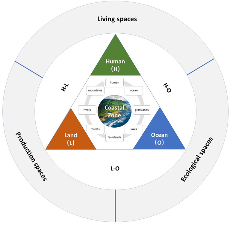
FIGURE 1. Theoretical basis of the index system construction.
Based on the aforementioned ideas, the coastal zone space is a huge and complex life system, so it conforms to the theoretical logic of “function-structure-element”. Among them, elements such as human, sea, and land (including mountains, rivers, forests, farmlands, lakes, and grasslands) are not only the basic constituent unit of the system but also the basis and carrier of the system. There are certain connections between the elements. The interrelated elements form the system according to a certain structure. The change of elements and structure will cause the change of system function, indicating that both elements and structure serve functional purpose. Conversely, at the beginning of the formation of the structure, it is necessary to clarify the functional objectives of the system so as to adopt the corresponding structure and control the elements. Therefore, based on these ideas, this study starts to construct the index system.
To build the index system, we first need to clarify the object of coastal zone use control, that is, the territorial space of the coastal zone so that the index system can be clearly implemented. A territorial space is a cross complex integrating entity space, function space, and management space (Yue and Wang, 2019). According to the theoretical viewpoint of “function-structure-element” in system theory, it can be seen that function space is the fundamental object of territorial space use control, and the structure comprising system elements is the basis of system function realization.
From the perspective of function, space utilization can be divided into three categories: production space, living space, and ecological space. Among them, production space is an area that provides industrial products, agricultural products, and service products, which pursues intensive land use and efficient output. Living space is an area that provides human living, consumption, leisure, and entertainment and pursues the convenience of service and livability. Ecological space is an area that provides ecological products and services. It plays an important role in regulating, maintaining, and ensuring regional ecological security and pursues the good development of ecological environment. The policy points out that by 2035, China should “basically form a space pattern with intensive and efficient production space, livable and appropriate living space, and beautiful ecological space”, which is the strategic goal of the Chinese government in the territorial space use control at the present stage and also the ultimate goal of the index system of this study. The policy objectives determine the key direction of the monitoring system. Therefore, this study divides the index system into three subsystems: ecological space, living space, and production space, also known as “ecological–production–living space” (Cui et al., 2018).
From the perspective of elements, territory use is reflected in more specific land/sea use types that constitute the ecological–production–living space, that is, the space utilization types of mountains, rivers, forests, farmlands, lakes, grasslands, seas, and cities in the concept of life community. Separately, the ecological space comprises forest land, grassland, wetland, and other ecological elements; production space consists of various spatial elements used in agriculture, fishery, industry, service industry, and other industries; living space comprises spatial elements closely related to human life. These specific land/sea use categories occupy a certain area in space and are staggered, showing a specific spatial structure, and there will be conversion among the elements. Generally, the ecological element types are often occupied by the element types of the other two spaces because the benefits cannot be directly expressed. Cultivated land in the production space is also an element type that is easy to be occupied. These phenomena will lead to the transformation of the internal structure of ecological–production–living space and affect the harmony of its functions, so the specific spatial elements that are in a weak position are often strictly protected. Therefore, this study infers from the theory of “element structure function”, and it holds that in order to achieve the functional goal of “production, ecology, and living space”, we need to refine from two major elements: element and structure.
The coastal zone is a strip area with a certain width extending from the coastline to both sides of the land and sea, and the scope of it has not been uniformly defined so far. The Millennium Ecosystem Assessment Project points out that the coastal zone is “the interface between the ocean and the land, extends to the middle of the continental shelf, and includes all areas affected by marine factors in the continental direction (Millennium Ecosystem Assessment, 2005). LOICZ defines the coastal zone as extending from 200 m land elevation to 200 m isobath (LOICZ working document, 2003). Alves et al. (2013) hold the view that the coastal zone takes the high tide line as the center, extends 2 km to the land area, and then extends to the sea area to the territorial sea boundary (the territorial sea baseline extends 12 nautical miles to the sea). However, Awosika and Marone (2000) and Glavovic et al. (2015) considered that the extension of the coastal zone to the sea side should reach the boundary line of the exclusive economic zone (the baseline of the territorial sea extends 200 nautical miles to the sea). At present, the view from the Environmental Council of the Organization for International Economic Cooperation and Development (OECD) is widely accepted internationally. It proposes that the definition and scope of the coastal zone need to be changed according to the problems dealt with and the objectives of management. In China, the national conditions with prominent contradiction between human and territorial space determine that the scope of coastal zone use control cannot be too broad but needs fine management. Considering China’s administrative system and population density, it is practical to take the township scale as the basic unit for the control of the coastal zone. Townships are widely distributed in the coastal zone, which is not only conducive to scientific research of the researchers but also convenient for managers to make overall arrangements and take action (Wen and Liu, 2019). For example, the Regulations on the Administration of Coastal Zone Protection and Utilization implemented in 2018 in Fujian Province states that the coastal zone refers to the intersection zone between the sea and the land, including the coastal land extending to the areas within the administrative divisions of the township and the nearshore sea extending to the baseline of the territorial sea. For the convenience of management, the coastal zone in this study also follows this scope.
In the process of territorial space use control in China, many departments have issued spatial plans for different control objectives. These plans are important means of national space governance and space policy tools for effectively regulating social, economic, and environmental factors. At present, China’s spatial planning system is a complex “planning matrix” comprising multi-type and multilevel spatial planning, mainly including major function-oriented zoning planning (including ocean) issued by the Development and Reform Commission; territorial planning and land use master planning issued by the Ministry of Land and Resources; urban planning issued by the Ministry of Housing and Urban–Rural Department; marine functional zoning and marine ecological environment protection planning issued by State Oceanic Administration; ecological environment protection planning issued by the Ministry of Environmental Protection; grassland protection, construction, and utilization planning and fishery planning issued by the Ministry of Agriculture; forest land protection and utilization planning and wetland protection planning issued by the State Forestry Administration; and special plans such as port planning issued by the Ministry of Transport. On the basis of these plans, a network space planning system of “horizontal juxtaposition and vertical to the end” has been formed (Liu and Wang, 2016). These plans have played a vital role in each stage of national land use control in China, and their index system provides a reference for the construction of the coastal spatial planning index system. Figure 2 shows the planning orientation, control objectives, and core indicators of China’s spatial planning. These are also the realistic basis and data source for “multiple planning integration” to build the coastal zone spatial planning index system.
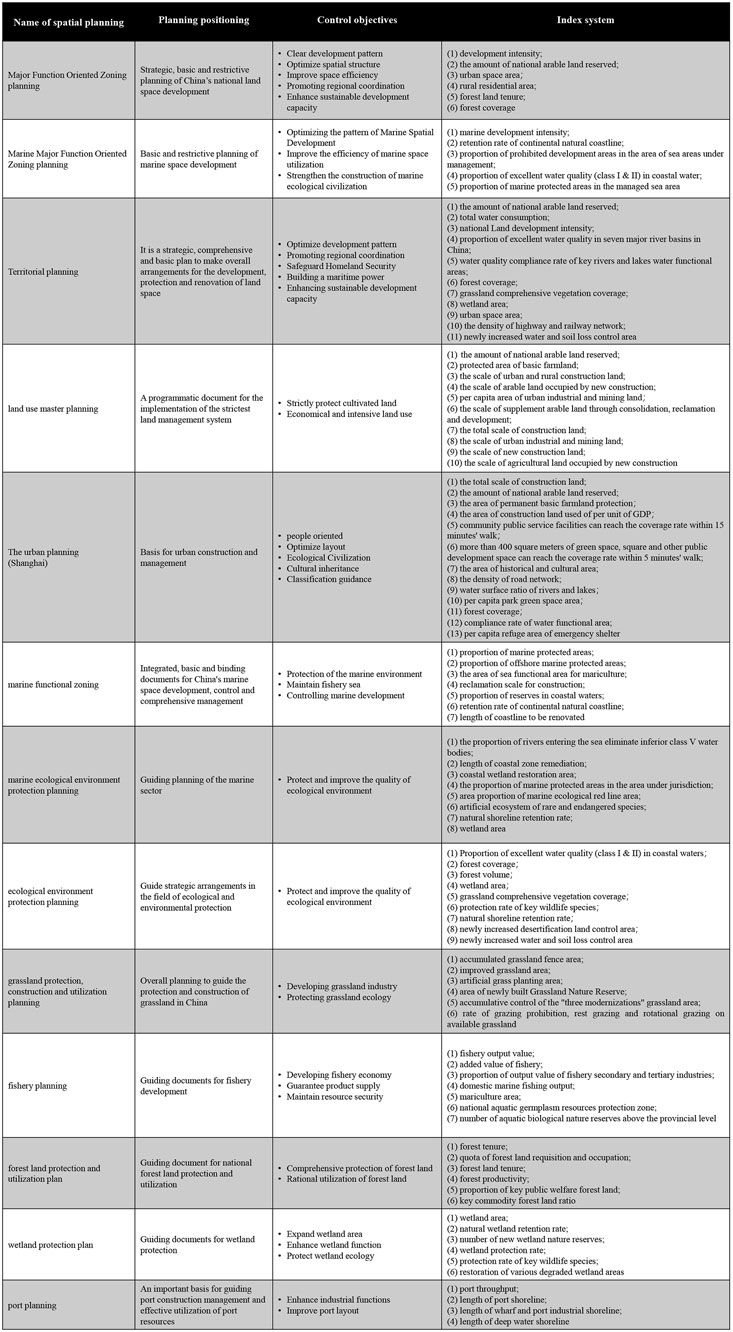
FIGURE 2. China’s existing spatial planning index system.
Due to the differences of regulation subjects, value orientation, and regulation objectives, there are two principal problems in China’s existing spatial planning index system (Figure 2). First, there are overlapping control contents among different plans. For example, for the control of arable land, the indicator of “the Amount of Cultivated Land Reserved” is set in the major function-oriented zoning planning, territorial planning, land use master planning, and urban planning; for the control of forest land, the indicator of “forest coverage” is set in the major function-oriented zoning planning, territorial planning, and ecological environment protection planning; for grassland control, territorial planning and ecological environment protection planning have set the indicator of “grassland comprehensive vegetation coverage” and so on. Second, there are different values of the same index. For example, for the index of “the amount of national arable land reserved”, the land use master plan (2006–2020) stipulates that it will reach 120.33 million hectares by 2020, while the national land planning outline (2016–2030) requires this value to be 124.33 million hectares. This situation can not only show the importance of the index, but it also leads to management contradictions and reduces control efficiency. Meanwhile, there are control gaps in these planning index systems. For example, these spatial planning index systems rarely involve controlling coastal living space and tourism land. For the spatial control gap, we should deeply understand its control connotation and determine the corresponding control indicators.
Based on the theoretical basis and connotation of coastal zone territorial spatial control, this study constructs the coastal zone spatial planning index system according to the path of “setting control objectives, setting control contents, and then setting control indicators” (Figure 3).

FIGURE 3. Construction idea of the coastal zone spatial control index system.
First, this study needs to determine the goal of the coastal zone monitoring index system, that is, to serve the high-quality development of the coastal zone. Second, starting from the territorial space function undertaken by ecological–production–living space, this study explores the classification system and its elements of ecological–production–living spaces in the coastal zone, and it constitutes the control content of the index system together with the structure of ecological–production–living spaces.
Among them, in order to realize the function of ecological-production-living spaces, the main control of elements is their total amount, bottom line, and quality; for the structure, it is to control the boundaries of different elements and the conversion between them. 1) Boundary is the spatial relationship between territorial space elements. It is divided according to different purposes to ensure that development, utilization, and protection activities can only be carried out in a specific space. 2) Conversion represents the dynamic conversion process between different territorial space types. Abandoning the previous concept of focusing only on the conversion of agricultural land use, we need to pay attention to the mutual conversion within the “mountains, rivers, forests, farmlands, lakes, grasslands, and sea” life community at this stage. 3) The total quantity is the control of the quantity state of specific elements and the expected target value. 4) The bottom line is the minimum standard and minimum defense line that must be maintained for land types with an important protection value. Breaking this standard will affect the country’s food security or ecological security and cause irreparable losses. 5) Quality is a kind of index that reflects the environmental quality, the quality of people’s life, and socioeconomics in the coastal space. The purpose is to evaluate the impact caused by the implementation of the index.
Finally, combined with the existing “multiplanning” index system in China, this study supplements the content of the control gap, determines the core indicators applicable to ecological–production–living spaces, and then constructs the coastal zone spatial control index system to serve the high-quality development of the coastal zone space.
Due to the overlapping and other contradictions in the index system of multiple departments, the National Development and Reform Commission, the Ministry of Land and Resources, the Ministry of Environmental Protection, and the Ministry of Housing and Urban–Rural Development of China jointly proposed to carry out the pilot work of “multiregulation integration” throughout the country in 2014. Since then, under the leadership of the government, all sectors of society have begun to explore “multi-compliance and integration”, with the purpose of absorbing the core points of various plans, coordinating the conflicts between plans, and building a unified land and space planning to allocate space resources more effectively.
As the coastal zone involves land–sea space, the life community of “landscape, forest, field, lake, grass, and sea” is fully reflected here. Generally, this area is regarded as the “main battlefield” to realize the land–sea overall management and “multiregulation integration”. At present, Chinese scholars have practiced the construction of a terrestrial multi-compliance index system (Bai and Tian, 2016; Wu et al., 2018); some scholars also explore the integration of marine spatial planning into a land-based multiplanning system (An et al., 2019; Yue et al., 2019), and they also developed and constructed the overall framework of comprehensive coastal zone planning (Jiang et al., 2018). However, the research on monitoring indicators of coastal space use control is still blank. Therefore, based on the existing spatial planning index system, this study constructs the spatial monitoring index system of land and sea overall management (Figure 4).
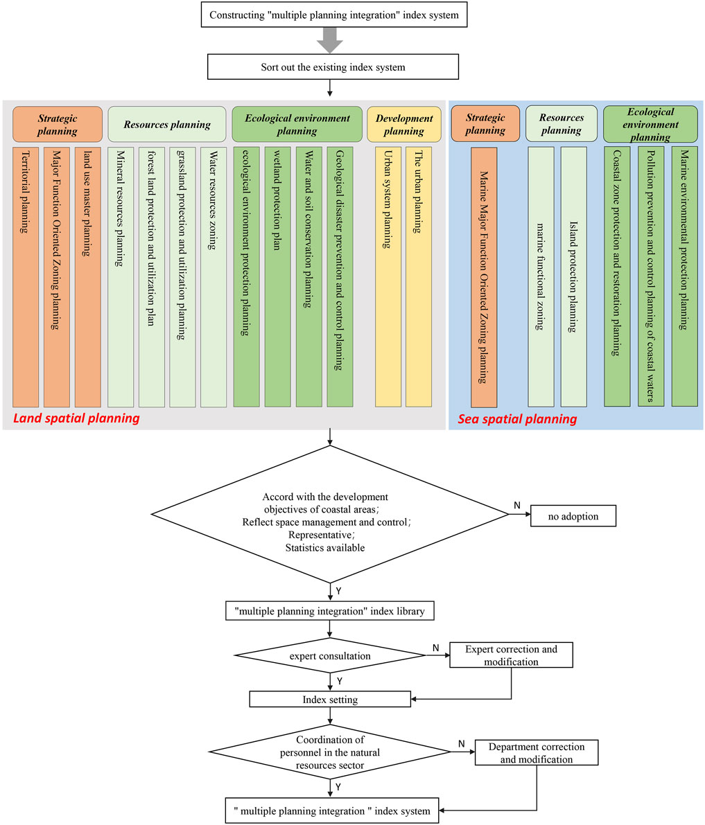
FIGURE 4. Schematic diagram of the “multiple planning integration” method.
After analyzing the “multiple planning” index system, this study first screened the key indexes according to the index selection principle and obtained the preliminary scheme of the “multiple planning” index database, including 55 basic indexes. In order to further screen the key indicators that play a practical role in coastal zone space control, this study further carries out expert consultation. In total, 12 experts from institutions of universities, local natural resource departments, enterprises in coastal areas, and other units were invited to determine the priority of monitoring indicators by understanding the stakeholders’ cognition of coastal zone use control, and it supplements the key contents in urgent need of supervision in the actual development of coastal zone areas through consultation.
Considering the overall structure and constituent elements of production–living–ecological spaces, the control content can cover all elements of the coastal zone. Chinese scholars have made many useful explorations on the classification of it (Huang et al., 2017; Liu et al., 2017; Cui et al., 2018; Huang et al., 2020). Referring to the research of Hu et al. (2020) and Zou et al. (2018), this study comprehensively classifies production–living–ecological spaces in the coastal zone involving 16 key-controlled land types (Table 1).

TABLE 1. Classification of “production-living-ecological spaces” in the coastal zone and its controlled land types.
Among them, the coastal production space is related to the industrial structure. It is an area with the leading function of providing industrial products, agricultural products, and service products, mainly including agricultural land, land for forestry, land for animal husbandry, sea for fishery production, industrial and mining land, and land for transportation. The coastal living space is related to carrying and ensuring human settlement. It is an area with the leading function of providing human residence, consumption, leisure, and entertainment, and it mainly includes land for urban construction, land for tourism and entertainment, and land for special purpose. The coastal ecological space is an area providing ecological products and ecological services, mainly including ecological land of prohibited construction, ecological land allowed for moderate construction, and ecological land of nurturing protective.
The indicators of the existing spatial planning are connected with the core management land-sea types of production-living-ecological spaces, and a coastal zone control index database is built, as shown in Figure 5.
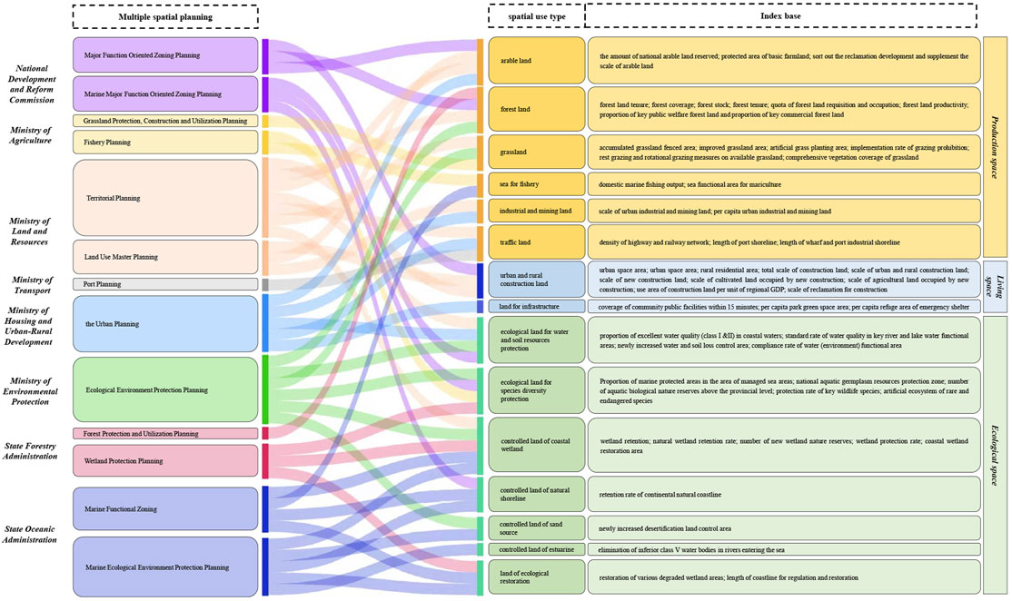
FIGURE 5. The index system of spatial planning is connected with production-living-ecological spaces. Notes for Figure 5: (1) we use different colors to represent the government departments of spatial planning in the column of “multiple spatial planning”; (2) three colors are used to distinguish the “production, ecology, and living space” and its elements on the right side; (3) the lines indicates the flow direction of the existing spatial planning index system.
It can be found that the control content of the existing spatial planning index system can cover all land–sea types of national land space. The index system of the Development and Reform Commission, the Ministry of Land and Resources, the Ministry of Housing and Urban-Rural Department, and the State Oceanic Administration can fully cover production–living–ecological spaces which are the four main departments of national land spatial use control in China’s coastal zone.
The indexes with high frequency and key control effects in the index library were preliminarily screened and then 20 key spatial types of indexes were determined through expert consultation. In addition, 13 key indicators are supplemented according to expert opinions. The coastal zone monitoring index system includes 33 monitoring indicators, as shown in Table 2.
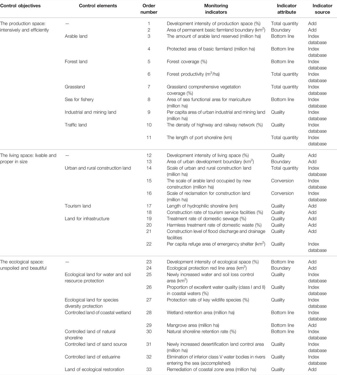
TABLE 2. Construction results of the coastal zone spatial planning monitoring index system.
1) Index system of production space in the coastal zone: ensures the total quantity of resources and the efficiency of production land.
In order to maintain China’s food security and ensure a controllable scale and quality of cultivated land, “the amount of arable land reserved” and “protected area of basic farmland” are proposed. In order to ensure the sustainable development of forestry, animal husbandry, fishery, and mining, indicators such as “forest coverage,” “forest productivity,” “grassland comprehensive vegetation coverage,” “area of sea functional area for mariculture,” and “per capita area of urban industrial and mining land” are set respectively. For the traffic land, two indicators of “the density of highway and railway network” and “the length of port shoreline” are set to ensure the regional traffic convenience of the coastal zone and promote the development of the industrial economy.
2) Index system of living space in the coastal zone: ensuring human security and people’s happiness.
For land for urban construction, the area and structure of urban and village space should be reasonably arranged, and the occupation of cultivated land and ecological land by new construction should be strictly limited; we set the indicators of “scale of urban and rural construction land,” “scale of arable land occupied by new construction,” and “scale of reclamation for construction land.” Tourism and entertainment space focuses on enhancing tourist experience and maintaining the scenic spot environment. This study combines scholars’ research on tourism (Liang and Ding, 2002; Zhang and Tan, 2002; Papageorgiou, 2016; Yang et al., 2021), constructed “length of hydrophilic shoreline,” and “construction rate of tourism service facilities” to improve the convenience and quality of coastal tourism activities. Special living land mainly refers to the control of infrastructure land (including waste disposal and another related land). Its control connotation is to ensure residential safety and environmental friendliness of the coastal zone. This study inherits the index of “per capita refuge area of emergency shelter” and supplements the three indexes of “construction level of flood discharge and drainage facilities,” “treatment rate of domestic sewage,” and “armless treatment rate of domestic waste,” in order to maintain the residential safety of the coastal zone and strictly control the treatment of urban waste.
3) Index system of ecological spatial in the coastal zone: maintaining coastal zone ecological security.
Prohibited ecological land refers to the land that is indispensable to maintaining ecological security and prohibited from any commercial development activities. This study inherits the indicators of “newly increased water and soil loss control area,” “proportion of excellent water quality (class I and II) in coastal waters,” and “protection rate of key wildlife species” in the index database, focusing on the strict protection of species resources in water and soil ecologically fragile areas and coastal zones. Controlled ecological land refers to the land that mainly plays ecological functions and allows humans to make appropriate or conditional use. This study inherits the index of “wetland retention area” in the index library. At the same time, due to the importance of mangroves for maintaining the coastal wetland ecosystem, the index of “mangrove area” is supplemented. In addition, this study adopts three indexes in the index library, such as “natural shoreline retention rate,” “newly increased desertification land control area,” and “elimination of inferior class V water bodies in rivers entering the sea,” in order to control the spatial types of natural shoreline, sand source, and estuary. Ecological conservation land refers to the land with degraded natural ecological functions but plays a key role in maintaining regional ecological balance. For the ecological restoration of the coastal zone, the existing spatial planning often uses the index of “length of remediation and restoration of the coastal zone”. Since the coastal zone area involves a range of space from the coastline to the sea and land, this index is adjusted to “remediation of the coastal zone area” to monitor the ecological restoration of land. By improving the stability and resilience of ecological patches, the purpose of unspoiled and beautiful in ecological space can be achieved.
The report’s “several opinions on establishing and supervising the implementation of the national land spatial planning system” clearly points out that it is necessary to “scientifically and orderly coordinate the layout of ecological, agricultural, urban, and other functional spaces; delimit the spatial control boundaries such as ecological protection red line, permanent basic farmland, and urban development boundary; and various sea area protection lines, in order to strengthen the bottom-line constraints”. Therefore, based on the index base with factor control as the core, this study supplements the indicators related to the regional control boundary of production–living–ecological spaces, and the intensity of land–sea development and implements the land space use control transmission mechanism of “ zoning + index”. Finally, we suggest that the management department controls the coastal territorial space according to the attribute of indicators. That is, government departments should strictly restrict the indicators of bottom line, boundary, and conversion and further improve the indicators of total amount and quality on the basis of reaching the expected objectives so as to make the control of the indicators more efficient and achieve the goal of high-quality development of coastal territorial space.
At present, Chinese governments are actively promoting the preparation and implementation of national land spatial planning. It is a major deployment made by the Chinese central government to establish a land spatial planning system and supervise its implementation, integrate spatial planning such as main functional area planning, land use planning, and urban and rural planning into a unified land spatial planning, and realize “multi-compliance and integration”. It is a major deployment made by the Chinese central government to achieve “multi-regulation integration” and establish a national land spatial planning system and supervise its implementation.
From the perspective of systems theory, this study puts forward an idea of constructing the monitoring index system of coastal use control. By connecting with the research hotspot of “production–living–ecological spaces,” the index system can be implemented. Specifically, taking the monitoring index system of coastal zone spatial planning as the research object, this study explores the new requirements for territorial spatial planning from the perspective of land–sea planning. From the perspectives of “zoning + indicators,” using the method of “multi-regulation integration,” this study puts forward the overall construction idea of controlling” objectives-contents-monitoring indicators,” constructs a systematic and hierarchical coastal zone spatial planning index system, which can make intensive and efficient production space, livable living space, and beautiful ecological space in coastal areas. First, it divides the production-living-ecological spaces in the coastal zone and determines the key spatial type of control, that is, the main contents of the control. By sorting out the existing spatial planning index system, the key controlled land types correspond to the existing index basis one by one, the duplicate indexes are deleted, and the blank indexes are supplemented to construct the coastal zone spatial planning index system. This study finds that some spatial elements play a prominent role in China’s territory use control, such as arable land, forest land, urban construction land, ecological land, and marine aquaculture functional area. This situation shows that under the previous separation of land and sea, the focus of China’s coastal zone space control is to protect inland food production land and ecological land. Moreover, due to the different natural nature of land and sea, the control of land area is more refined, and the control of sea area and living space quality is relatively lacking. At present, the main contradiction in the Chinese society has become the contradiction between the people’s growing need for a better life and unbalanced and insufficient development. Therefore, on the premise of paying attention to food security and ecological security in coastal areas, the construction of living land for people’s high-quality needs to be enhanced in the future. This study can provide theoretical reference for the coastal zone spatial planning and enrich the coastal zone use control system. In the future management process, policy executors should manage coastal zone areas according to local conditions and add characteristic indicators or delete invalid indicators for specific areas, which will have a better effect.
This study only provides an idea of constructing the index system. However, the classification of production–living–ecological spaces is still in the exploratory stage at present, which means that the relationship between “function” and “element” is still unclear in the construction idea of the index system. In reality, a spatial use element may correspond to more than one function. For example, cultivated land mainly not only plays the function of food production, but it also plays ecological function. In the future, the classification and index determination of ecological–production–living spaces still need to be further explored in order to enhance the practicability of the research. In addition, the indicators applicable to territorial space under different scales are different. In the future, the indicator system of different administrative levels should be determined from the coastal zone of national, provincial, city, county, and township. The construction of an index system is a complex systematic project. It is necessary to clarify the responsibilities and positioning in land and space planning as soon as possible, jointly promote the research on land and space planning indicators in coastal zone, provide strong support for land and space monitoring and early warning mechanism in coastal zone, and comprehensively build a safe, efficient, harmonious, competitive, and sustainable coastal zone space.
The original contributions presented in the study are included in the article/Supplementary Material, further inquiries can be directed to the corresponding authors.
ZG, JW, and YH: conceptualization, methodology, writing—original draft preparation, formal analysis, and visualization. ZG, LY, and YB: investigation, resources, and data curation. JW and YH: writing—review and editing, supervision, project administration, and funding acquisition. All authors have read and agreed to the published version of the manuscript.
This work was supported by the National Natural Science Foundation of China (grant number 41877034), the Fundamental Research Funds for the Central Universities (grant number 2652018036), and a projected entitled “Construction of Monitoring Indicators for Space Use Control in Coastal Zone” funded by the National Marine Data and Information Service, Ministry of Natural Resources of People’s Republic of China.
The authors declare that the research was conducted in the absence of any commercial or financial relationships that could be construed as a potential conflict of interest.
All claims expressed in this article are solely those of the authors and do not necessarily represent those of their affiliated organizations, or those of the publisher, the editors, and the reviewers. Any product that may be evaluated in this article, or claim that may be made by its manufacturer, is not guaranteed or endorsed by the publisher.
Alam, M. W., Xiangmin, X., Ahamed, R., Mozumder, M. M. H., and Schneider, P. (2021). Ocean Governance in Bangladesh: Necessities to Implement Structure, Policy Guidelines, and Actions for Ocean and Coastal Management. Reg. Stud. Mar. Sci. 45, 101822. doi:10.1016/j.rsma.2021.101822
Alves, F. L., Sousa, L. P., Almodovar, M., and Phillips, M. R. (2013). Integrated Coastal Zone Management (ICZM): a Review of Progress in Portuguese Implementation. Reg. Environ. Change 13 (5), 1031–1042. doi:10.1007/s10113-012-0398-y
An, T. T., Zhu, Q. L., Yue, Q., and Liu, N. N. (2019). Exploring the Questions and Approaches about Multiple Spatial Planning’s Integration on marine Spatial Planning in China. Trans. Oceanology Limnology 3, 28–35. (in Chinese). doi:10.13984/j.cnki.cn37-1141.2019.03.004
Awosika, L., and Marone, E. (2000). Scientific Needs to Assess the Health of the Oceans in Coastal Areas: a Perspective of Developing Countries. Ocean Coastal Manage. 43 (8-9), 781–791. doi:10.1016/S0964-5691(00)00062-4
Bai, W., and Tian, Z. Q. (2016). Establishment of the Indicator System for Yulin Land Space Planning. J. Land Resour. Inf. 3, 41–45. (in Chinese).
Bax, N., Novaglio, C., Maxwell, K. H., Meyers, K., McCann, J., Jennings, S., et al. (2021). Ocean Resource Use: Building the Coastal Blue Economy. Rev. Fish. Biol. Fish. 32, 189–207. doi:10.1007/s11160-021-09636-0
Bullimore, B. (2014). Problems and Pressures, Management and Measures in a Site of marine Conservation Importance: Carmarthen Bay and Estuaries. Estuarine, Coastal Shelf Sci. 150, 288–298. doi:10.1016/j.ecss.2014.05.005
Chen, X., and Qian, W. (2020). Effect of marine Environmental Regulation on the Industrial Structure Adjustment of Manufacturing Industry: An Empirical Analysis of China's Eleven Coastal Provinces. Mar. Pol. 113, 103797. doi:10.1016/j.marpol.2019.103797
Cui, J. X., Gu, J., Sun, J. W., and L, J. (2018). The Spatial Pattern and Evolution Characteristics of the Production, Living and Ecological Space in Hubei Provence. China Land Sci. 32 (08), 67–73. (in Chinese). doi:10.11994/zgtdkx.20180723.121720
Glavovic, B., Limburg, K., Liu, K.-K., Emeis, K.-C., Thomas, H., Kremer, H., et al. (2015). Living on the Margin in the Anthropocene: Engagement Arenas for Sustainability Research and Action at the Ocean-Land Interface. Curr. Opin. Environ. Sustainability 14, 232–238. doi:10.1016/j.cosust.2015.06.003
Goodhead, T., and Aygen, Z. (2007). Heritage Management Plans and Integrated Coastal Management. Mar. Pol. 31 (5), 607–610. doi:10.1016/j.marpol.2007.03.005
Grafton, R. Q., Doyen, L., Béné, C., Borgomeo, E., Brooks, K., Chu, L., et al. (2019). Realizing Resilience for Decision-Making. Nat. Sustain. 2 (10), 907–913. doi:10.1038/s41893-019-0376-1
Guo, Y. C. (2020). Experience Learned from English East Inshore and Offshore Marine Plans. Ocean Develop. Manage. 37 (02), 19–25. (in Chinese).
Guo, Z., Hu, Y., and Zheng, X. (2020). Evaluating the Effectiveness of Land Use Master Plans in Built-Up Land Management: A Case Study of the Jinan Municipality, Eastern China. Land Use Policy 91, 104369. doi:10.1016/j.landusepol.2019.104369
Hu, H., Huang, P. Y., and Zhang, M. M. (2020). Classification System of Ecological-Living-Industrial Spaces in Coastal Zone Based on the Coordinated Land-Sea Development. Ocean Develop. Manage. 37 (05), 14–18. (in Chinese).
Huang, A., Xu, Y., Lu, L., Liu, C., Zhang, Y., Hao, J., et al. (2020). Research Progress of the Identification and Optimization of Production-Living-Ecological Spaces. Prog. Geogr. 39 (03), 503–518. (in Chinese). doi:10.18306/dlkxjz.2020.03.014
Huang, J. C., Lin, H. X., and Qi, X. X. (2017). A Literature Review on Optimization of Spatial Development Pattern Based on Ecological-Production-Living Space. Prog. Geogr. 36 (03), 378–391. (in Chinese). doi:10.18306/dlkxjz.2017.03.014
Humphrey, S., Burbridge, P., and Blatch, C. (2000). US Lessons for Coastal Management in the European Union. Mar. Pol. 24 (4), 275–286. doi:10.1016/S0308-597x(00)00003-8
Jiang, Y. M., Li, J. L., Ma, R. F., Wu, D. D., Wang, T. F., and Ye, M. Y. (2018). Integrated Control of Coastal Zone Based on the Multiple Planning Integration. China Land Sci. 32 (02), 34–39. (in Chinese). doi:10.11994/zgtdkx.20180224.145740
Lee, J. (1998). Policy Issues and Management Framework of Chinhae Bay, Republic of Korea. Ocean Coastal Manage. 38 (2), 161–178. doi:10.1016/S0964-5691(97)00071-9
Li, B., Wang, Z., Chai, J., and Zhang, D. (2019). Index System to Assess Implementation of Strategic Land Use Plans in China. Land Use Policy 88, 104148. doi:10.1016/j.landusepol.2019.104148
Liang, X. C., and Ding, D. S. (2002). Trends of Overseas Studies of Ocean and Coastal Tourism. J. Nat. Resour. 06, 783–791. (in Chinese).
Lin, Q., and Yu, S. (2018). Losses of Natural Coastal Wetlands by Land Conversion and Ecological Degradation in the Urbanizing Chinese Coast. Sci. Rep. 8, 15046. doi:10.1038/s41598-018-33406-x
Linton, D. M., and Warner, G. F. (2003). Biological Indicators in the Caribbean Coastal Zone and Their Role in Integrated Coastal Management. Ocean Coastal Manage. 46 (3-4), 261–276. doi:10.1016/S0964-5691(03)00007-3
Liu, J. L., Liu, Y. S., and Li, Y. R. (2017). Classification Evaluation and Spatial-Temporal Analysis of "Production-Living-Ecological" Spaces in China. Acta Geographica Sinica 72 (07), 1290–1304. (in Chinese). doi:10.11821/dlxb201707013
Liu, Y. S., and Wang, J. Y. (2016). Theoretical Analysis and Technical Methods of "multiple Planning Integration" in the Rural to Urban Transition Period in China. Prog. Geogr. 35 (5), 529–536. (in Chinese). doi:10.18306/dlkxjz.2016.05.001
LOICZ working document (2003). Version II: LOICZ Future-Beyond 2002.04. Den Burg, Netherlands: LOICZ.
Milanés Batista, C., Suárez, A., and Botero Saltarén, C. M. (2017). Novel Method to Delimitate and Demarcate Coastal Zone Boundaries. Ocean Coastal Manage. 144, 105–119. doi:10.1016/j.ocecoaman.2017.04.021
Millennium Ecosystem Assessment (2005). Ecosystems and Human Well-Being: Wetlands and Water Synthesis. Washington, DC: World Resource Institute. Available at: http://www.millenniumassessment.org/en/index.html.
Nie, X., Wu, J., Zhang, W., Zhang, J., Wang, W., Wang, Y., et al. (2021). Can Environmental Regulation Promote Urban Innovation in the Underdeveloped Coastal Regions of Western China? Mar. Pol. 133, 104709. doi:10.1016/j.marpol.2021.104709
Papageorgiou, M. (2016). Coastal and marine Tourism: A Challenging Factor in Marine Spatial Planning. Ocean Coastal Manage. 129, 44–48. doi:10.1016/j.ocecoaman.2016.05.006
Smith, A. J., Barber, J., Davis, S., Jones, C., Kotra, K. K., Losada, S., et al. (2021). Aquatic Contaminants in Solomon Islands and Vanuatu: Evidence from Passive Samplers and Microtox Toxicity Assessment. Mar. Pollut. Bull. 165, 112118. doi:10.1016/j.marpolbul.2021.112118
Su, H., and Liang, B. (2021). The Impact of Regional Market Integration and Economic Opening up on Environmental Total Factor Energy Productivity in Chinese Provinces. Energy Policy 148, 111943. doi:10.1016/j.enpol.2020.111943
van Alphen, J. (1995). The Voordelta Integrated Policy Plan: Administrative Aspects of Coastal Zone Management in the Netherlands. Ocean Coastal Manage. 26 (2), 133–150. doi:10.1016/0964-5691(95)00018-W
Wang, B., Xin, M., Wei, Q., and Xie, L. (2018). A Historical Overview of Coastal Eutrophication in the China Seas. Mar. Pollut. Bull. 136, 394–400. doi:10.1016/j.marpolbul.2018.09.044
Wen, C. X., and Liu, J. X. (2019). Review and Prospect of Coastal Zone Planning Based on Land and Sea Integration. Planners 7, 5–11. (in Chinese).
Wu, J., Song, Y., Lin, J., and He, Q. (2018). Tackling the Uncertainty of Spatial Regulations in China: An Institutional Analysis of the "Multi-Plan Combination". Habitat Int. 78, 1–12. doi:10.1016/j.habitatint.2018.07.002
Xu, X., Li, X., Chen, M., Li, X., Duan, X., Zhu, G., et al. (2016). Land-ocean-human Interactions in Intensively Developing Coastal Zone: Demonstration of Case Studies. Ocean Coastal Manage. 133, 28–36. doi:10.1016/j.ocecoaman.2016.09.006
Yan, D., Yao, X., Li, J., Qi, L., and Luan, Z. (2021). Shoreline Change Detection and Forecast along the Yancheng Coast Using a Digital Shoreline Analysis System. Wetlands 41 (4), 47. doi:10.1007/s13157-021-01444-3
Yang, W., Cai, F., Liu, J., Zhu, J., Qi, H., and Liu, Z. (2021). Beach Economy of a Coastal Tourist City in China: A Case Study of Xiamen. Ocean Coastal Manage. 211, 105798. doi:10.1016/j.ocecoaman.2021.105798
Yu, G., Liao, Y., Liao, Y., Zhao, W., Chen, Q., Kou, J., et al. (2021). Research on Integrated Coastal Zone Management Based on Remote Sensing: A Case Study of Guangxi Beibu Gulf. Reg. Stud. Mar. Sci. 44, 101710. doi:10.1016/j.rsma.2021.101710
Yuan, W., and Chang, Y.-C. (2021). Land and Sea Coordination: Revisiting Integrated Coastal Management in the Context of Community Interests. Sustainability 13 (15), 8183. doi:10.3390/su13158183
Yue, Q., Xu, W., Li, Y. N., Teng, X., Dong, Y. E., and Hu, H. (2019). Integrating marine Functional Zoning into ‘Multiple-Plan Integration’ from the Perspective of Territorial Space. J. Mar. Dev. Manag. 36 (06), 3–6. (in Chinese).
Yue, W. Z., and Wang, T. Y. (2019). Rethinking on the Basic Issues of Territorial and Spatial Use Control in China. China Land Sci. 33 (08), 8–15. (in Chinese). doi:10.11994/zgtdkx.20190722.151305
Zhang, M., Chen, Y., Hu, W., Deng, N., and He, W. (2021). Exploring the Impact of Temperature Change on Residential Electricity Consumption in China: The 'crowding-Out' Effect of Income Growth. Energy and Buildings 245, 111040. doi:10.1016/j.enbuild.2021.111040
Zhang, R. Q., and Tan, Y. Y. (2002). Study on Development and protection of Coastal Tourism. Coastal Eng. 04, 60–65. (in Chinese).
Zhao, X., Zhang, Q., He, G., Zhang, L., and Lu, Y. (2021). Delineating Pollution Threat Intensity from Onshore Industries to Coastal Wetlands in the Bohai Rim, the Yangtze River Delta, and the Pearl River Delta, China. J. Clean. Prod. 320, 128880. doi:10.1016/j.jclepro.2021.128880
Zhou, S. T., Zhai, G. F., and Shi, Y. J. (2018). Indicator-based Monitoring Framework of Spatial Planning in England and its Inspirations. Int. Urban Plann. 33 (05), 126–131. (in Chinese). doi:10.22217/upi.2017.245
Keywords: coastal zone space use control, monitoring index system, land–sea overall management, multiple planning integration, China’s coastal areas
Citation: Guo Z, Hu Y, Bai Y, Yang L and Wang J (2022) How to Control Coastal Zone Through Spatial Planning? Taking the Construction of the Spatial Monitoring Index System of the Coastal Zone in China as an Example. Front. Environ. Sci. 10:876414. doi: 10.3389/fenvs.2022.876414
Received: 15 February 2022; Accepted: 01 April 2022;
Published: 16 May 2022.
Edited by:
Jinyan Zhan, Beijing Normal University, ChinaReviewed by:
Yanxu Liu, Beijing Normal University, ChinaCopyright © 2022 Guo, Hu, Bai, Yang and Wang. This is an open-access article distributed under the terms of the Creative Commons Attribution License (CC BY). The use, distribution or reproduction in other forums is permitted, provided the original author(s) and the copyright owner(s) are credited and that the original publication in this journal is cited, in accordance with accepted academic practice. No use, distribution or reproduction is permitted which does not comply with these terms.
*Correspondence: Yecui Hu, aHV5Y0BjdWdiLmVkdS5jbg==; Jieyong Wang, d2p5QGlnc25yci5hYy5jbg==
Disclaimer: All claims expressed in this article are solely those of the authors and do not necessarily represent those of their affiliated organizations, or those of the publisher, the editors and the reviewers. Any product that may be evaluated in this article or claim that may be made by its manufacturer is not guaranteed or endorsed by the publisher.
Research integrity at Frontiers
Learn more about the work of our research integrity team to safeguard the quality of each article we publish.