 Enxiang Cai
 Qingsheng Bi1
- 1School of Resources and Environment, Henan Agricultural University, Zhengzhou, China
- 2College of Forestry, Henan Agricultural University, Zhengzhou, China
Studies on urban expansion in megacities are essential for managing urban sprawl to promote high-quality development. In this study, we have selected the emerging megacity of Zhengzhou as the research area, used the spatial analysis method to quantify the spatiotemporal characteristics of urban expansion from 1990 to 2020, and evaluated the rationality of urban expansion on the basis of the elasticity index and a comparison with other megacities. Results demonstrated that 1) Zhengzhou experienced great urban expansion from 1990 to 2020 and showed a trend of “steady–fast–slow,” with steady expansion from 1990 to 2000, fast expansion from 2000 to 2010, and slow expansion after 2010; 2) Zhengzhou’s urban expansion has obvious imbalance and spatial disorder, mainly concentrated in the urban central area, and is characterized by sprawl or a leap in space; 3) the occupation of cultivated land by urban expansion in Zhengzhou has gradually decreased, but the occupation of ecological land such as water areas has increased significantly, which may lead to a series of negative ecological effects; 4) Zhengzhou’s urban expansion was inefficient, while the utilization intensity and economic benefits of Zhengzhou’s urban construction land have improved, but relatively lower than those of other megacities in China. The findings have important reference that is significant for promoting the sustainable urban expansion of megacities and achieving sustainable regional development.
1 Introduction
Rapid economic and population growth have led to an unprecedented increase in urban construction land, and urban expansion has become a global geographic phenomenon in the process of urbanization (Schneider and Woodcock, 2014; Tayyebi et al., 2014). As the carrier of social and economic activities, the expansion of urban construction land not only meets the growing social needs of urban residents but also provides important support for sustainable regional development (Bagan and Yamagata, 2014). However, in recent decades, the rapid urbanization in the world, especially in developing countries, has triggered the disorderly sprawl of urban construction land, which has a profound negative impact on resources (Hu et al., 2017; Lafortezza and Sanesi, 2019), the environment (Hamidi and Ewing, 2014), geographic processes (Liu et al., 2008; Xu et al., 2009), biodiversity (Kovács et al., 2019), etc. and has become one of the most important factors that hinder sustainable regional and even global development (He et al., 2018). Exploring the mechanism of urban expansion, proposing strategies to prevent urban sprawl, and realizing sustainable development have become core topics of urban research.
In the middle of the twentieth century, many scholars began to conduct systematic research on urban expansion (Dai et al., 2010). A large number of scholars have used spatial analysis tools to conduct quantitative research on urban expansion from a geographic perspective (Buyantuyev et al., 2015; Hecht et al., 2020), mainly focusing on measuring urban expansion from the characteristics of land scale and spatial form, and building a series of index models such as expansion intensity index (Yue et al., 2016), expansion steady state index (Zhao et al., 2017), expansion elasticity index (Rusk, 1993), and sprawl index (Tian et al., 2017). With the technological innovation of geographic information systems and spatial statistics, the driving forces, prediction, and simulation of urban expansion have become research hot spots (Kantakumar et al., 2016; Zhang et al., 2018; Zhong et al., 2020; Liu et al., 2022). With the increasing pressure on resources and the environment, the sustainability of urban expansion needs to be discussed, and the rationality of urban expansion has attracted growing interest from urban planners and managers (Tong, 2020). Urban expansion can cause complex changes in regional natural systems. Whether it will lead to ecological degradation (Chien and Saito, 2021), food security issues (Gren and Andersson, 2018), and climate change (Khamchiangta and Dhakal, 2021) has become an important criterion for judging the rationality of urban expansion. Analyzing the coordination between urban expansion, population growth, and economic development by using the decoupling model (Cai et al., 2020) and the elastic coefficient (Jiao et al., 2016) is an important way of evaluating urban expansion. Although previous research generated an impressive body of work, urban expansion research mainly focuses on mature megacities and less on not well-known emerging megacities that have important regional influence and are undergoing rapid socioeconomic transformation. In addition, the urban expansion evaluation is mainly based on the expansion scale and effects of the city itself, and comparative analysis with similar cities is lacking. These comparisons have an important reference for judging the rationality of urban expansion.
Since the implementation of the reform and opening-up policy, China has made world-renowned urban development achievements, and a number of world-influential megacities such as Beijing, Shanghai, and Shenzhen have emerged. The seventh national census in 2020 shows that 21 megacities in China have a population of more than 5 million in central urban areas (CNBS, 2020). These megacities are not only clusters of job creation and population living but also core areas that support economic development and participate in international competition (Sassen, 1994). However, under the traditional urban development model oriented by economic growth in the past, Chinese megacities have seen a wave of blind expansion, which has caused problems such as loss of arable land, traffic congestion, skyrocketing land prices, and environmental pollution (Chen et al., 2013; Li et al., 2014). Megacities occupy a pivotal position in socioeconomic development, and the resource and environmental problems faced by their urban expansion are more serious than those faced by small- and medium-sized cities. Unlike the urbanization of mature megacities, which has stagnated, the urbanization of emerging megacities is still developing rapidly, and the demand for urban expansion continues to be strong. The expansion of emerging megacities has obvious diversity and differences, and the problems encountered in urban management are more complex (Yao et al., 2009). Therefore, a systematic study needs to be conducted on the characteristics and rationality of urban expansion in China’s emerging megacities, and high-quality and sustainable urban expansion needs to be achieved.
This study takes Zhengzhou, a city in central China, as the research area to study the urban expansion of emerging megacities. The main purposes of this work are 1) to measure the spatiotemporal characteristics of urban expansion from 1990 to 2020; 2) to judge the rationality of urban expansion through the coordination of urban expansion, economy, and population, and a comparison with other megacities; and 3) to propose targeted suggestions for urban expansion management and provide a reference for the development of emerging megacities.
2 Materials and Methods
2.1 Study Area
Zhengzhou is the capital of Henan Province in central China (34°16′–34°58′N and 112°42′–114°14′), adjacent to the lower Yellow River in the north. Zhengzhou covers an area of 7446.2 km2, of which the central urban area covers 1181.51 km2. As the core city of China’s central plains urban agglomeration, one of the eight national central cities and an important national comprehensive transportation hub (NDRC, 2017), Zhengzhou is experiencing rapid economic growth and urbanization. In 2020, the permanent population was 12.6 million, of which the non-agricultural population accounted for 78.4%. Furthermore, its GDP was 1200.3 billion RMB (Zhengzhou Bureau of Statistics, 2021). Zhengzhou had a population of 5.34 million in the central urban area in 2020, becoming one of the 21 cities in China with a population in the central urban area exceeding 5 million, and it is an emerging megacity in China. Zhengzhou has 12 administrative districts, including 6 districts [Jinshui (JS), Zhongyuan (ZY), Erqi (EQ), Guancheng (GC), Huiji (HJ), and Shangjie (SJ)], 5 county-level cities [Xinzheng (XZ), Xinmi (XM), Xingyang (XY), Gongyi (GY), and Dengfeng (DF)], and 1 county [Zhongmo (ZM)] (Figure 1).
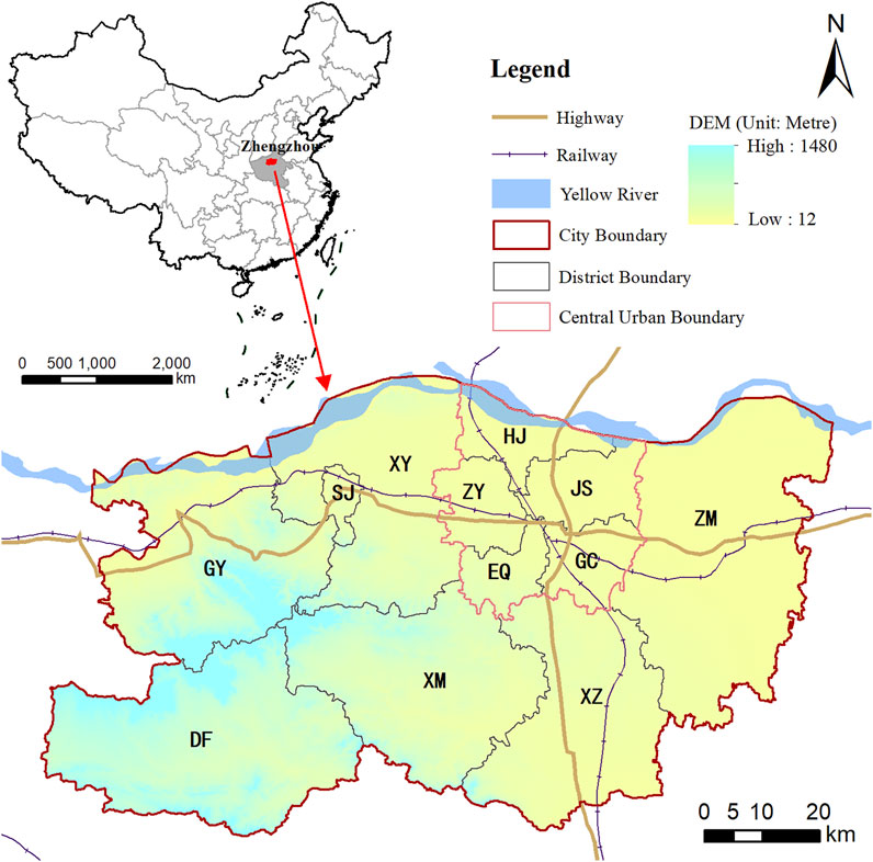
FIGURE 1. Location and administrative districts of Zhengzhou.
From 1990 to 2020, Zhengzhou’s socioeconomic status experienced rapid development. The urban population and GDP increased significantly. The urban population increased from 2.38 million to 9.89 million, an increase of 3.15 times. Meanwhile, the urbanization rate increased from 42.7 to 78.4%, an increase of 35.7 percentage points. GDP increased from 11.64 billion yuan to 1,200 billion yuan, an increase of 102.12 times (Figure 2). Furthermore, the urban population and GDP growth continue to accelerate, and Zhengzhou’s urbanization is still in the stage of rapid development.
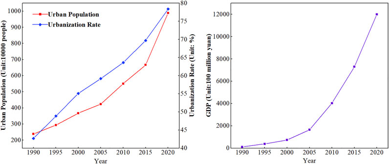
FIGURE 2. Socioeconomic development of Zhengzhou from 1990 to 2020.
2.2 Data
This study collected multi-temporal remote sensing images (Landsat TM/ETM+) and obtained land use and land cover (LUCC) data at the time nodes of 1990, 1995, 2000, 2005, 2010, 2015, and 2020, with a spatial resolution of 30 m. According to the LUCC classification system proposed by the Institute of Geographic Sciences and Natural Resources Research of the Chinese Academy of Sciences, with the use of supervised classification and human–computer interaction interpretation to extract information, the interpreted land use types were divided into 6 categories and 25 subcategories (Liu et al., 2003). After quality inspection and data integration, the comprehensive evaluation accuracy of land use types reached more than 94.3%. The urban construction land defined by this research refers to the urban land used for construction such as industrial and mining land, residential land, and roads. The urban expansion monitoring process of Zhengzhou was based on LUCC maps from 1990 to 2020 (Figure 3). The socioeconomic data used were mainly derived from the annual socioeconomic statistics published by the official websites of the national-, provincial-, and prefecture-level municipal statistical departments.
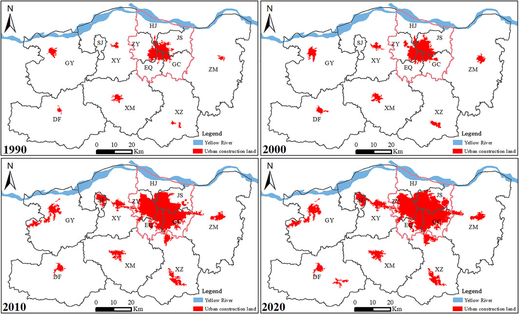
FIGURE 3. Spatial allocation of urban construction land in 1990, 2000, 2010, and 2020.
2.3 Methods
2.3.1 Average Annual Expansion Index
The urban expansion index refers to the percentage of the growth area of urban construction land in its original urban construction land area within a certain period. A large index value corresponds to fast urban expansion. This study uses the average annual urban expansion index (AAEI) to analyze the characteristics of urban expansion in Zhengzhou. The specific calculation formula is as follows:
where I refers to the AAEI; Ui and Uj represent the area of urban construction land in the base period and the end period of the study period, respectively; and n is the number of years in the period.
The AAEI was used to analyze the three phases of urban expansion in the various districts of Zhengzhou from 1990 to 2000, 2000 to 2010, and 2010 to 2020. According to the urban expansion characteristics of each district, urban expansion was divided into three types: low-, medium-, and high-speed expansion based on the AAEI value ranges of 0–5, 5–10, and >10, respectively.
2.3.2 Urban Expansion Elasticity Index
The urban expansion elasticity index is mainly divided into the man-land elasticity index and the economic-land elasticity index. Urban construction land is the carrier of urban residents’ life and economic activities. The carrying population and economic scale are important indicators to measure the rationality of urban expansion. The urban expansion man-land elasticity index refers to the ratio of the growth rate of the urban construction land area to the growth rate of the urban population during the study period; the urban expansion economic-land elasticity index refers to the ratio of the regional GDP growth rate to the growth rate of the urban construction land area within the study period. The specific calculation formulas are as follows:
where PEI and GEI refer to the man-land elasticity index and the economic-land elasticity index, respectively; Pi and Pj are the number of urban permanent residents in the base and end of the study period, respectively; and Gi and Gj are the GDP in the base and end of the study period, respectively.
2.3.3 Indexes of Urban Expansion Efficiency
The efficiency of urban expansion was mainly analyzed from two aspects: urban construction land intensive use and economic benefits. Per capita urban construction land area and per capita GDP are the most important indicators to measure urban construction land intensive use and economic benefits, respectively, and can also provide an important reference for evaluating whether urban expansion is reasonable. The index’s calculation formulas are as follows:
where PA and PE refer to the per capita urban construction land area and per capita GDP, respectively; UCLA is the urban construction land area; UP is the urban population; and GDP is the gross domestic product.
3 Results
3.1 Spatiotemporal Characteristics of Urban Expansion
3.1.1 Temporal Characteristics of Urban Expansion
According to the statistical results of land use data from Landsat TM/ETM + image interpretation, from 1990 to 2020, the area of urban construction land in Zhengzhou increased from 168.23 to 751.26 km2, with an increase rate of 346.57% and an average annual increase of 19.43 km2. During the study period, Zhengzhou’s urban construction land showed a “steady-fast-slow” expansion trend (Figure 4). The growth rate from 1990 to 2000 was relatively stable, with an average annual growth rate of 5.36%; from 2000 to 2010 was a period of rapid growth, with an average annual growth rate of 14.4%; and from 2010 to 2020, the growth rate gradually slowed down, with an average annual growth rate of 1.91%. Especially during 2015–2020, the average annual growth rate is only 0.38%, which was the lowest in 1990–2020.
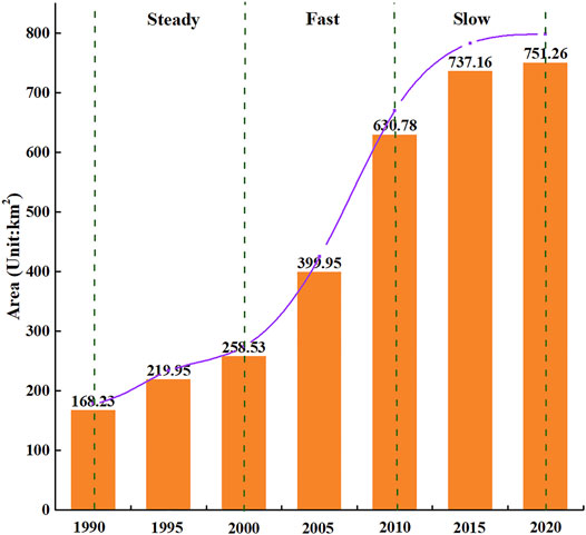
FIGURE 4. The process of urban construction land expansion from 1990 to 2020.
3.1.2 Spatial Characteristics of Urban Expansion
The data on urban construction land in Zhengzhou in 1990, 2000, 2010, and 2020 were extracted, and the expansion of urban construction land in Zhengzhou from 1990 to 2020 was obtained by the spatial overlay analysis (Figure 5). The urban expansion in Zhengzhou has obvious spatial differences. The urban expansion of the central city was mainly in three directions: east, south, and west, with the east and south having a larger expansion and being the main areas of urban development in Zhengzhou. The urban development space was limited, and the expansion was small during the study period because of the obstruction of the Yellow River in the north. In Xinzheng, Xinmi, Xingyang, and Zhongmu, which are adjacent to the central urban area, the urban expansion direction was mainly toward the central urban area, indicating that the urban development in these areas was obviously driven by the central urban area, and their urban development space was gradually integrated with the central urban area. The urban expansion direction of Gongyi in the outer suburbs was mainly to the west. The urban expansion directions were diverse, and new urban spaces appeared in the later stage of the study because of the influence of the mountains in Dengfeng. The north and southwest of the central urban area were difficult to develop because of the restrictions by geological factors such as the Yellow River basin and the mountainous terrain. Most of the available areas in the central urban area have been developed, and the urban expansion space is faced with a shortage.
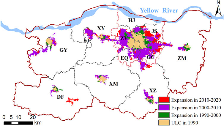
FIGURE 5. Distribution of urban construction land (UCL) expansion from 1990 to 2020.
From 1990 to 2020, Guancheng and Jinshui had the largest urban expansion areas of 116.57 and 101.29 km2, respectively. Except for Shangjie, the largest average annual expansion indexes were those for Xinzheng and Guancheng, reaching 27.96 and 20.44, respectively. Seven high-speed expansion regions, three medium-speed expansion regions, and two low-speed expansion regions were developed during this period (Table 1). The urban expansion rate in the central urban area was generally low, and the areas with a larger expansion rate were mainly in the outer suburbs. Most of the districts experienced rapid urban expansion, among which the central urban area had the largest expansion, and its urban expansion area accounted for 63% of Zhengzhou.
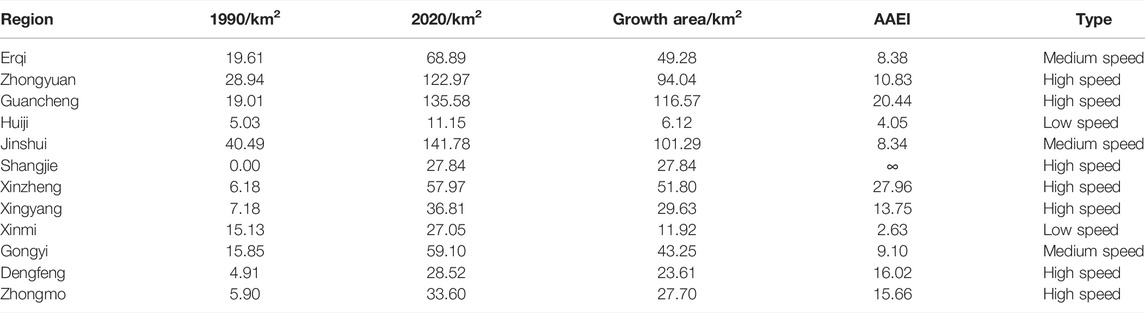
TABLE 1. Characteristics of urban construction land expansion from 1990 to 2020.
3.1.3 Land Use Effects of Urban Expansion
From 1990 to 2020, the urban expansion area of Zhengzhou was 587.84 km2. The land occupied by urban expansion was mainly arable land, with an area of 471.88 km2, accounting for 80.27%; followed by construction land with an occupied area of 77.02 km2, accounting for 13.1%; and then followed waters, with an occupied area of 20.19 km2, accounting for 3.44%. Spatially, in addition to arable land, a large amount of waters (mainly rivers and lakes) in the northeast and west of the central urban area is occupied (Figure 6). The conversion of rural residential land to urban construction land was mainly concentrated in Shangjie and Gongyi.
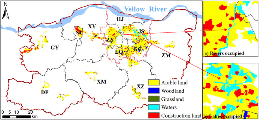
FIGURE 6. Distribution of the land occupied by urban expansion.
Although arable land was the main type of land occupied by urban expansion, its proportion dropped from 88.89% in 1990–2000 to 69.44% in 2010–2020; the proportion of construction land occupied by urban expansion increased from 10.34% in 1990–2000 to 17.62% in 2010–2020. The proportion of occupied waters grew the fastest, from 0.69% in 1990–2000 to 15.8% in 2010–2020. This finding shows that with the strengthening of cultivated land protection, urban expansion reduces the occupation of cultivated land, and more land is converted from village land to urban land (Table 2). However, the occupation of water bodies has increased rapidly, indicating that the erosion of ecological land by urban expansion has intensified, and caution needs to be taken to avoid damage to the natural ecology, especially water ecology.
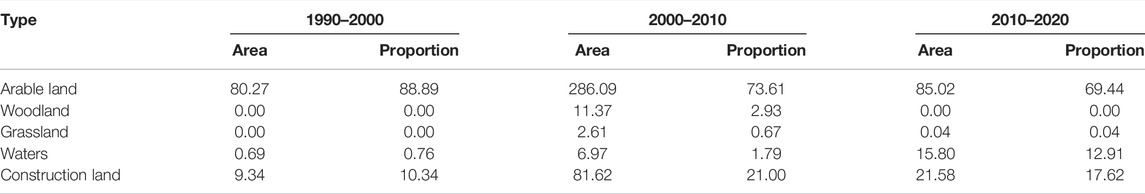
TABLE 2. Changes in the structure of the urban expansion sources (Units: km2, %).
3.2 Rationality of Urban Expansion in Zhengzhou
3.2.1 Elasticity Indexes of Urban Expansion
As shown in Figure 7, the man-land elasticity index of urban expansion increased from 1.32 to the peak of 3.52 in 2000–2005 and then continued to decrease, indicating that Zhengzhou’s urban expansion was generally too rapid relative to the population growth from 1990 to 2010, and urban land use was relatively extensive. After 2010, the elasticity index was lower than 1 and reached a very low value of 0.04 in 2015–2020. The urban expansion rate began to be lower than the urban population growth rate, the population density of urban land gradually increased, and land use tended to be intensive. The economic land elasticity index of urban expansion showed a “U” shape. During the study period, Zhengzhou’s GDP growth rate was always greater than the urban expansion rate. The elasticity index dropped from 7.55 to 2.34 during 1990–2005 and then began to grow slowly, increasing to 33.54 during 2015–2020. This finding shows that the economic benefits of urban land use continued to improve. Although the rate of improvement declined during 1990–2005, it began to accelerate significantly thereafter, and the economic benefits of urban land use increased significantly in the later period.
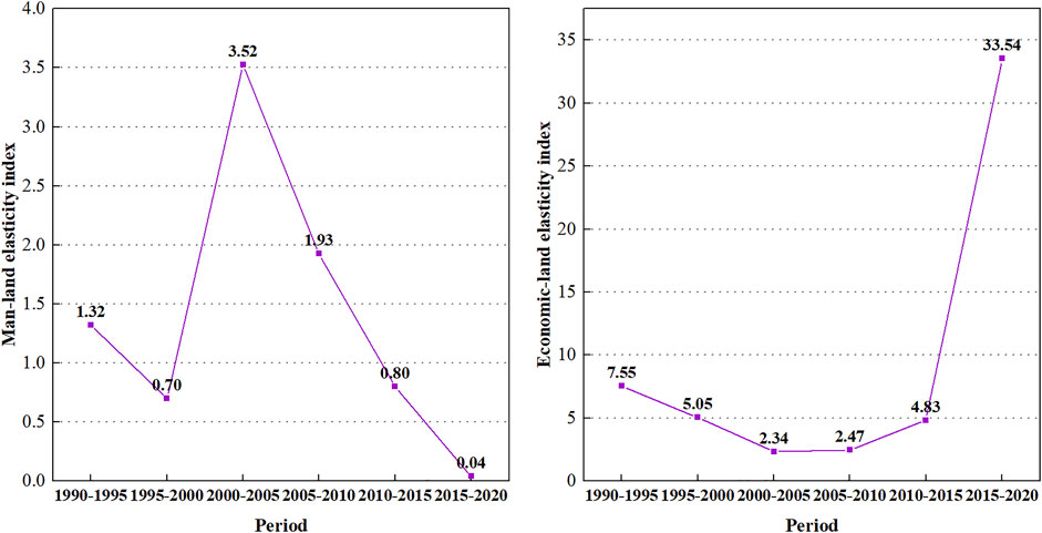
FIGURE 7. Variation of elastic coefficient of urban expansion from 1990 to 2020.
3.2.2 Comparative Analysis Among Similar Megacities
According to China’s urban classification standards, cities with a population of more than 5 million in the central urban area are considered megacities (SCC, 2014). In 2020, China had 21 megacities, which are mainly located in central and eastern China (Figure 8). These megacities account for 7.5% of China’s area, but they carry 20.7% of the population and generate 33.1% of the GDP. These megacities are the core force that supports China’s economic development and participates in international competition.
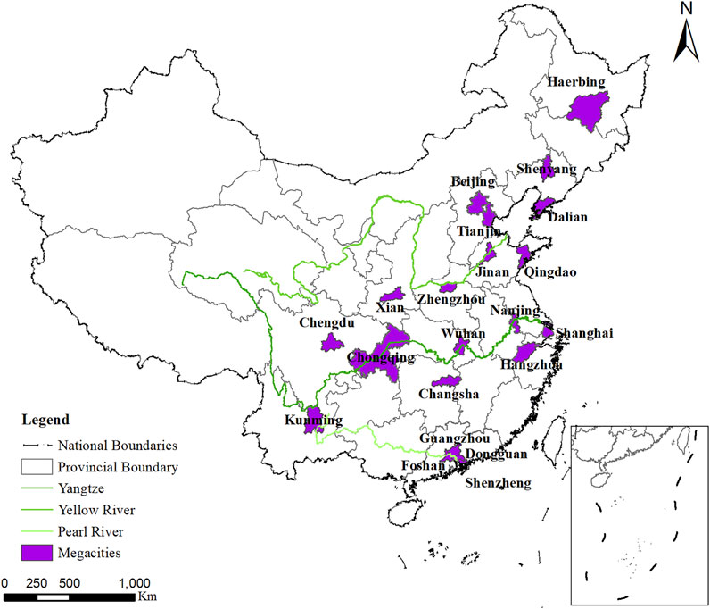
FIGURE 8. Location of China’s megacities.
3.2.2.1 Area of Urban Construction Land Expansion
From 1990 to 2020, Zhengzhou’s urban construction land area has always been in the middle of 21 megacities, but the ranking continues to increase, from 14th in 1990 to 10th in 2020 (Figure 9). This finding shows that the growth rate of urban construction land in Zhengzhou is higher than the average growth rate of China’s megacities. During the study period, Zhengzhou’s urban construction land area increased by 583.03 km2, which was 13% higher than the average growth area of 515.97 km2 in megacities. The expansion of urban construction land in Zhengzhou was growing rapidly in megacities.
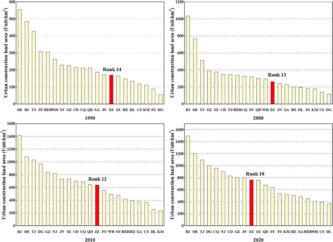
FIGURE 9. Urban construction land area of China’s megacities from 1990 to 2020. BJ, Beijing; SH, Shanghai; GZ, Guangzhou; SZ, Shenzhen; TJ, Tianjin; DG, Dongguan; NJ, Nanjing; CQ, Chongqing; SY, Shenyang; FS, Foshan; JN, Jinan; CD, Chengdu; ZZ, Zhengzhou; XA, Xian; HZ, Hangzhou; WH, Wuhan; QD, Qingdao; KM, Kunming; HEB, Haerbing; DL, Dalian; CS, Changsha.
3.2.2.2 Efficiency of Urban Construction Land
In 2020, Zhengzhou’s per capita urban construction land area was 77.21 m2, and the per capita GDP was 1.574 billion yuan/hm2, ranking 13th and 15th among China’s megacities, respectively (Figure 10), which are significantly lower than the ranking of construction land area. Although Zhengzhou has experienced relatively rapid expansion among China’s megacities, its land use efficiency has lagged behind the average level. The intensive use and economic benefits of urban construction land in Zhengzhou reached only 50.97 and 41.22% of the top megacities in China, respectively, indicating that the urban land use efficiency remains unsatisfactory. Under the increasing pressure of land supply and environmental protection faced by urban development, the urban expansion model of Zhengzhou needs to transform from the past spatial sprawl to one with improved land use efficiency.
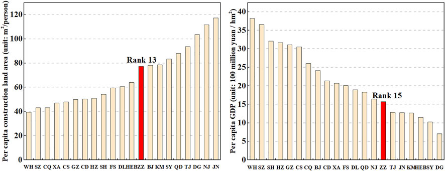
FIGURE 10. Efficiency of urban construction land of China’s megacities in 2020. BJ, Beijing; SH, Shanghai; GZ, Guangzhou; SZ, Shenzhen; TJ, Tianjin; DG, Dongguan; NJ, Nanjing; CQ, Chongqing; SY, Shenyang; FS, Foshan; JN, Jinan; CD, Chengdu; ZZ, Zhengzhou; XA, Xian; HZ, Hangzhou; WH, Wuhan; QD, Qingdao; KM, Kunming; HEB, Haerbing; DL, Dalian; CS, Changsha.
4 Discussion
4.1 Climate Effects of Urban Expansion
Previous studies on the negative effects of urban expansion mainly focused on the loss of arable land, landscape destruction, and deterioration of human settlements, often ignoring the climatic lag effects of urban expansion (Camacho-valdez et al., 2014). The occupation of arable land by urban expansion has been curbed because of China’s increasingly stringent arable land protection policy. However, wetlands and grasslands were usually regarded as unused land by urban managers without protection and were freely occupied by urban expansion. The spatial analysis of Zhengzhou urban expansion shows that a large number of rivers and lakes in Zhengzhou, especially in the central urban area, have been occupied. The area of waters in the central urban area of Zhengzhou decreased from 95.58 km2 in 1990 to 66.89 km2 in 2020, with a reduction rate of 42.89%. The substantial reduction of the water body area has destroyed the urban permeable surface, which not only further aggravates the water shortage in Zhengzhou as a city in arid regions of the northern hemisphere but also weakens the city’s ability to withstand floods.
Zhengzhou experienced a historically rare catastrophic rainstorm and urban waterlogging in the summer of 2021, which brought major property losses and casualties (Zhang et al., 2021). In addition to the natural extreme rainstorm factors, the occupation of rivers and lakes by urban expansion made the rainwater unable to be discharged in time, which may also play an important role in the worsening of this disaster. Emerging megacities are still in the stage of rapid urban development, and the negative climate effects of urban expansion may not yet appear. Research on the prediction of climate disasters that may be caused by improper urban expansion should be carried out to take appropriate countermeasures in advance. The climate effects of urban expansion should also attract the attention of managers and planners of other emerging megacities in the world.
4.2 Urban Expansion Evaluation System
Rapid population and economic growth in emerging megacities have driven urban expansion, while also making urban land use more intensive and efficient. Therefore, if the urban expansion is evaluated based on the city’s conditions only, then the results of urban expansion evaluation are mostly satisfied, and finding the problem of urban expansion is difficult (Tan et al., 2010). As megacities face greater difficulty with land supply and more severe environmental constraints, there should be higher standards for urban land-use. Comparative analysis with similar or higher-level megacities may have different conclusions from the evaluation based on the city’s conditions.
This study adopts an urban expansion evaluation method that combines socioeconomic coupling analysis with a comparison of similar cities. The socioeconomic coupling analysis shows that the economic benefits and intensive utilization of Zhengzhou’s urban land use have improved, and urban land use has developed in a positive direction in the process of urban expansion. However, in comparison with other similar megacities in China, Zhengzhou’s urban expansion was too fast, and its economic benefits and intensive utilization were relatively low. This comprehensive urban expansion evaluation method facilitates the detection of urban expansion problems and avoids the one-sidedness of the evaluation conclusion, which provides important insights into the urban management of emerging megacities.
4.3 Recommendations for Future Study
By analyzing the spatiotemporal characteristics and rationality of urban expansion in Zhengzhou, this study strengthens the cognition of urban expansion in emerging megacities and provides significant reference for cities undergoing rapid development and growth. However, some problems need to be explored in future research. First, systematic research should be conducted on megacity groups, rather than just a single or a few cities. The expansion of megacities at different development stages shows obvious differences, and the study of the urban expansion of megacity groups is helpful for exploring the urban expansion mechanism of megacities. Second, research on the relationship between urban expansion and meteorological disasters should be strengthened. Unreasonable human activities in the process of urban expansion may be the cause of meteorological disasters. Understanding the relationship between the two can help in the implementation of countermeasures.
5 Conclusion
Taking Zhengzhou as an example, this study analyzes the spatiotemporal characteristics of urban expansion in China’s emerging megacities and the rationality for urban expansion on the basis of the man-land elasticity index, the economic-land elasticity index, and a comparison with other megacities. It then summarizes urban expansion problems and presents relevant suggestions. These findings have important reference significance for curbing the disorderly sprawl of megacities, realizing smart management of megacities and promoting regional sustainable development. The main conclusions were as follows:
1) During the study period, the urban expansion of Zhengzhou showed a trend of “steady–fast–slow.” From 1990 to 2000, the urban expansion of Zhengzhou was relatively stable, and from 2000 to 2010, it entered a stage of rapid expansion. After 2010, the urban expansion of Zhengzhou entered a slow stage due to the constraints on the expansion of the central urban area.
2) Zhengzhou urban expansion has obvious imbalance and spatial disorder. The growth area of urban construction land in the central urban area, which accounts for only 13.44% of Zhengzhou, accounts for 63% of the city’s total. The suburban urban expansion was more disorderly, and the central urban area expansion was limited by the Yellow River in the north and the mountainous areas in the southwest. The space for urban development is insufficient. In the future, urban development should transform from single-core development of the central urban area to coordinated development of the central urban area and the suburbs.
3) Urban expansion has gradually increased the occupation of water bodies, and the ecological problems of urban expansion have become prominent. Although the area occupied by waters was relatively small during the urban expansion of Zhengzhou, its proportion has since increased significantly. With Zhengzhou being a rapidly developing emerging megacity with relative water shortage, the occupation of ecological land such as waters may damage the carrying capacity of urban water resources and cause a series of natural ecological problems.
4) Zhengzhou’s urban expansion was inefficient. Although the utilization intensity and economic benefits of Zhengzhou’s urban construction land have continued to improve, compared with other megacities in China, Zhengzhou’s urban expansion was too fast, and the urban construction land utilization intensity and economic benefits were relatively low.
Data Availability Statement
The original contributions presented in the study are included in the article/Supplementary Material, further inquiries can be directed to the corresponding author.
Author Contributions
Conceptualization and writing: EC and HH; methodology and software: EC and QB; data acquisition: QB; and analysis and interpretation of data: JL.
Funding
This research was funded by the Henan Philosophy and Social Science Planning Project (no. 2019CHH078), Humanities and Social Sciences Research Projects of Higher Education Institutions in Henan Province (no. 2011-ZZJH-157), Zhengzhou Soft Science Research Project (no. 2020RKXF0104), and Major consulting and research projects of institute local cooperation of Chinese Academy of Engineering(no. 2021HENZDA04).
Conflict of Interest
The authors declare that the research was conducted in the absence of any commercial or financial relationships that could be construed as a potential conflict of interest.
Publisher’s Note
All claims expressed in this article are solely those of the authors and do not necessarily represent those of their affiliated organizations, or those of the publisher, the editors, and the reviewers. Any product that may be evaluated in this article, or claim that may be made by its manufacturer, is not guaranteed or endorsed by the publisher.
References
Bagan, H., and Yamagata, Y. (2014). Land-cover Change Analysis in 50 Global Cities by Using a Combination of Landsat Data and Analysis of Grid Cells. Environ. Res. Lett. 9 (6), 064015. doi:10.1088/1748-9326/9/6/064015
Buyantuyev, A., Wu, J., and Gries, C. (2015). Multiscale Analysis of the Urbanization Pattern of the Phoenix Metropolitan Landscape of USA: Time, Space and Thematic Resolution. Landscape Urban Plann. 94 (3-4), 206–217. doi:10.1016/j.landurbplan.2009.10.00.5
Cai, E., Liu, Y., Li, J., and Chen, W. (2020). Spatiotemporal Characteristics of Urban-Rural Construction Land Transition and Rural-Urban Migrants in Rapid-Urbanization Areas of Central China. J. Urban Plann. Dev. 146 (1), 05019023. doi:10.1061/(ASCE)UP.1943-5444.0000551
Camacho-Valdez, V., Ruiz-Luna, A., Ghermandi, A., Berlanga-Robles, C. A., and Nunes, P. A. L. D. (2014). Effects of Land Use Changes on the Ecosystem Service Values of Coastal Wetlands. Environ. Manage. 54 (4), 852–864. doi:10.1007/s00267-014-0332-9
Chen, M., Liu, W., and Tao, X. (2013). Evolution and Assessment on China's Urbanization 1960-2010: Under-urbanization or Over-urbanization? Habitat Int. 38 (4), 25–33. doi:10.1016/j.habitatint.2012.09.007
Chien, H., and Saito, O. (2021). Evaluating Social-Ecological Fit in Urban Stream Management: The Role of Governing Institutions in Sustainable Urban Ecosystem Service Provision. Ecosystem Serv. 49, 101285. doi:10.1016/j.ecoser.2021.101285
China National Bureau of Statistics (CNBS) (2020). Major Figures on 2020 Pupulation Census of China. AvaliableAt: http://www.stats.gov.cn/tjsj/pcsj/rkpc/d7c/202111/P020211126523667366751.pdf (Retreved December 22, 2021).
Dai, J., Gao, X., and Du, S. (2010). Expansion of Urban Space and Land Use Control in the Process of Urbanization: An Overview. Chin. J. Popul. Resour. Environ. 8 (3), 73–82. doi:10.1080/10042857.2010.10684994
Gren, Å., and Andersson, E. (2018). Being Efficient and green by Rethinking the Urban-Rural divide-Combining Urban Expansion and Food Production by Integrating an Ecosystem Service Perspective into Urban Planning. Sust. Cities Soc. 40, 75–82. doi:10.1016/j.scs.2018.02.031
Hamidi, S., and Ewing, R. (2014). A Longitudinal Study of Changes in Urban Sprawl between 2000 and 2010 in the United States. Landscape Urban Plann. 128, 72–82. doi:10.1016/j.landurbplan.2014.04.021
He, C., Liu, Z., Gou, S., Zhang, Q., Zhang, J., and Xu, L. (2018). Detecting Global Urban Expansion over the Last Three Decades Using a Fully Convolutional Network. Environ. Res. Lett. 14 (3), 034008. doi:10.1088/1748-9326/aaf936
Hecht, R., Behnisch, M., and Herold, H. (2020). Innovative Approaches, Tools and Visualization Techniques for Analysing Land Use Structures and Dynamics of Cities and Regions (Editorial). J. Geovisualization Spat. Anal. 4 (2), 1–4. doi:10.1007/s41651-020-00060-9
Hu, X., Zhou, W., Qian, Y., and Yu, W. (2017). Urban Expansion and Local Land-Cover Change Both Significantly Contribute to Urban Warming, but Their Relative Importance Changes over Time. Landscape Ecol. 32 (4), 763–780. doi:10.1007/s10980-016-0484-5
Jiao, L., Dong, T., and Yanyan, G. U. (2016). The Spatial Resilience of Prefecture-Level Cities in China from 2000 to 2012. Resour. ence 38 (7), 1254–1265. doi:10.18402/resci.2016.07.07
Kantakumar, L. N., Kumar, S., and Schneider, K. (2016). Spatiotemporal Urban Expansion in Pune metropolis, India Using Remote Sensing. Habitat Int. 51, 11–22. doi:10.1016/j.habitatint.2015.10.007
Khamchiangta, D., and Dhakal, S. (2021). Future Urban Expansion and Local Climate Zone Changes in Relation to Land Surface Temperature: Case of Bangkok Metropolitan Administration, Thailand. Urban Clim. 37, 100835. doi:10.1016/j.uclim.2021.100835
Kovács, Z., Farkas, Z. J., Egedy, T., Kondor, A. C., Szabó, B., Lennert, J., et al. (2019). Urban Sprawl and Land Conversion in post-socialist Cities: The Case of Metropolitan Budapest. Cities 92, 71–81. doi:10.1016/j.cities.2019.03.018
Lafortezza, R., and Sanesi, G. (2019). Nature-based Solutions: Settling the Issue of Sustainable Urbanization. Environ. Res. 172, 394–398. doi:10.1016/j.envres.2018.12.063
Li, J., Zhang, W., Sun, T., and Zhang, A. (2014). Characteristics of Clustering and Economic Performance of Urban Agglomerations in China. Acta Geographica Sinica 69 (4), 474–484. doi:10.11821/dlxb201404004
Liu, G., Li, J., and Nie, P. (2022). Tracking the History of Urban Expansion in Guangzhou (China) during 1665-2017: Evidence from Historical Maps and Remote Sensing Images. Land Use Policy 112, 105773. doi:10.1016/j.landusepol.2021.105773
Liu, J., Liu, M., Zhuang, D., Zhang, Z., and Deng, X. (2003). Study on Spatial Pattern of Land-Use Change in China during 1995–2000. Sci. China 46, 374–384. doi:10.1360/03yd9033
Liu, M., Tian, H., Chen, G., Ren, W., Zhang, C., and Liu, J. (2008). Effects of Land-Use and Land-Cover Change on Evapotranspiration and Water Yield in China during 1900-20001. J. Am. Water Resour. Assoc. 44 (5), 1193–1207. doi:10.1111/j.1752-1688.2008.00243.x
Naitonal Development, and Reform Commission (NDRC) (2017). Reply of the National Development and Reform Commission on Supporting Zhengzhou to Build a National central City. AvaliableAt: https://www.ndrc.gov.cn/xwdt/ztzl/xxczhjs/ghzc/201701/t20170125_972047.html?code=&state=123 (Retreved December 23, 2021).
Schneider, A., and Woodcock, C. E. (2014). Compact, Dispersed, Fragmented, Extensive? A Comparison of Urban Growth in Twenty-Five Global Cities Using Remotely Sensed Data, Pattern Metrics and Census Information. Urban Stud. 45 (3), 659. doi:10.1177/0042098007087340
State Council of China (2014). Circular of the State Council on Adjusting the Classification Standards of the City Size. AvaliableAt: http://www.gov.cn/zhengce/content/2014-11/20/content_9225.htm (Retreved December 29, 2021).
Tan, K. C., Lim, H. S., MatJafri, M. Z., and Abdullah, K. (2010). Landsat Data to Evaluate Urban Expansion and Determine Land Use/land Cover Changes in Penang Island, Malaysia. Environ. Earth Sci. 60 (7), 1509–1521. doi:10.1007/s12665-009-0286-z
Tayyebi, A., Perry, P. C., and Tayyebi, A. H. (2014). Predicting the Expansion of an Urban Boundary Using Spatial Logistic Regression and Hybrid Raster–Vector Routines with Remote Sensing and GIS. InternationaL J. Geographical Inf. Sci. 28 (3-4), 639–659. doi:10.1080/13658816.2013.845892
Tian, L., Li, Y., Yan, Y., and Wang, B. (2017). Measuring Urban Sprawl and Exploring the Role Planning Plays: A Shanghai Case Study. Land Use Policy 67, 426–435. doi:10.1016/j.landusepol.2017.06.002
Tong, L. (2020). A Review on Definitions and Measurements for Urban Expansion. World Reg. Stud. 29 (4), 762–772. doi:10.17576/geo-2021-1702-10
Xu, H., Ding, F., and Wen, X. (2009). Urban Expansion and Heat Island Dynamics in the Quanzhou Region, China. IEEE J. Sel. Top. Appl. Earth Observations Remote Sensing 2 (2), 74–79. doi:10.1109/JSTARS.2009.2023088
Yao, S., Chen, S., Wu, J., Zhang, Y., and Chan, R. (2009). Spatial Expansion Patterns of Chinese Big Cities the Case of Suzhou. Scientia Geographica Sinica 29 (1), 15–21. doi:10.1007/978-3-642-00205-2_9
Yue, W., Zhang, L., and Liu, Y. (2016). Measuring Sprawl in Large Chinese Cities along the Yangtze River via Combined Single and Multidimensional Metrics. Habitat Int. 57, 43–52. doi:10.1016/j.habitatint.2016.06.009
Zhang, W., Liao, Q., Yang, S., Zhang, X., Zhang, C., Xiang, M., et al. (2021). Thoughts and Inspirations: Urban Flood Risk Management Inferred from Zhengzhou Flood Model. China Flood Drought Manag. 31 (9), 1–4. doi:10.16867/j.issn.1673-9264.2021251
Zhang, Z., Liu, F., Zhao, X., Wang, X., Shi, L., Xu, J., et al. (2018). Urban Expansion in China Based on Remote Sensing Technology: A Review. Chin. Geographical Sci. 28 (05), 727–743. doi:10.1007/s11769-018-0988-9
Zhao, G., Zheng, X., Liu, Y., and Liu, F. (2017). Urban Expansion Steady-State index of Urban Expansion Based on Remote Sensing and GIS and its Applications. Trans. Chin. Soc. Agric. Eng. 33 (11), 272–281. doi:10.11975/j.issn.1002-6819.2017.11.035
Zhengzhou Bureau Of Statistics (2021). Zhengzhou City's Annual Statistics. AvaliableAt: http://tjj.zhengzhou.gov.cn/ndsj/index.jhtml (Retreved December 23, 2021).
Keywords: sustainable development, spatiotemporal characteristics, urban expansion, emerging megacity, Zhengzhou
Citation: Cai E, Bi Q, Lu J and Hou H (2022) The Spatiotemporal Characteristics and Rationality of Emerging Megacity Urban Expansion: A Case Study of Zhengzhou in Central China. Front. Environ. Sci. 10:860814. doi: 10.3389/fenvs.2022.860814
Received: 23 January 2022; Accepted: 21 March 2022;
Published: 26 April 2022.
Edited by:
Ding Ma, Shenzhen University, ChinaReviewed by:
Hao Zhang, Fudan University, ChinaLuyi Tong, China University of Geosciences Wuhan, China
Qingsong He, Huazhong University of Science and Technology, China
Copyright © 2022 Cai, Bi, Lu and Hou. This is an open-access article distributed under the terms of the Creative Commons Attribution License (CC BY). The use, distribution or reproduction in other forums is permitted, provided the original author(s) and the copyright owner(s) are credited and that the original publication in this journal is cited, in accordance with accepted academic practice. No use, distribution or reproduction is permitted which does not comply with these terms.
*Correspondence: Heping Hou, MjAwOTIwMjA1MDAyN0B3aHUuZWR1LmNu