 Pei Huang
 Yonggen Sun
 Donggi Gu1,2
 Yong Chen
- 1First Institute of Oceanography, Ministry of Natural Resources, Qingdao, China
- 2Key Laboratory of Coastal Science and Integrated Management, Ministry of Natural Resources, Qingdao, China
- 3College of Environmental Science and Engineering, Ocean University of China, Qingdao, China
Seawater desalination water intake site selection has an important impact on the investment, water production cost, stable operation, and safety of seawater desalination plants. Site selection is affected by many factors, such as the natural geography, ecological environment, and social economy of coastal zones; some constraints can be directly identified as unsuitable areas for these construction projects. For the shallow water intake method of seawater desalination, this study selects suitability evaluation indicators for seawater desalination water intake site selection from the three influencing factors of basic geography, water environment, and industrial development and constructs a suitability evaluation model based on the multifactor spatial overlay analysis of the Geographic Information System platform. This model carries out a quantitative suitability evaluation of the seawater desalination water intake site selection and realizes the suitable spatial zoning for spatially selecting the water intake, thus forming a scientific, quantitative, and spatial suitability evaluation system for this process. The evaluation method was applied in the Rongcheng city offshore area of China and analyzed. The evaluation results showed that the suitable areas for seawater desalination water intake site selection comprised 304.8 square kilometers, which were mainly distributed in the offshore areas in northern Rongcheng city and near the coastline areas of its central and southern regions. The unsuitable areas covered 292.4 square kilometers, mainly distributed in the marine ecological red line areas and the coastal aquaculture areas of Rongcheng city. The evaluation results met the site selection needs of the seawater desalination water intake project in Rongcheng city. This study improves upon the existing method of seawater desalination intake site selection at the theoretical and technical levels and provides a scientific basis for the location selection and planning for water intake in large spatial ranges of coastal waters.
1 Introduction
Seawater desalination is an important strategic solution to the contradiction between water resource supply and demand. Additionally, desalination can optimize the structure of water resources, and ensure the security of the water supply in coastal areas around the world. Thus, desalination plays an important role in ensuring the sustainable utilization of water resources and promoting the transformation of the economic development model (Glueckstern, 2003; Elabbar and Elmabrouk, 2005; Elabbar, 2008; Ramírez et al., 2019; Dawoud et al., 2020; Elsaid et al., 2020; Zhang et al., 2020). Seawater desalination technologies are grouped into two categories: membrane desalination, mainly Reverse Osmosis (RO), and thermal desalination, mainly Multiple Stage Flashing (MSF) and Multiple Effect Distillation (MED) (Ahmad et al., 2020; Ahmed et al., 2020; Eke et al., 2020; Lin et al., 2021). As an important part of a desalination plant, seawater intake ensures that sufficient, continuous, and suitable raw water is provided throughout the life cycle of the plant. The selection of a water intake location has important impacts on the investment in the seawater desalination plant, water production cost, stable operation of the system, and ecological environment (KRESHMAN, 1985; Morton et al., 1996; Gille, 2003; Andrianne and Ftlix, 2004; Tsiourtis, 2008; Darwish et al., 2016; Shahabi et al., 2017; Missimer and Maliva, 2018; Al-Kaabi and Mackey, 2019; Aydin and Sarptas, 2019). The water intake methods of seawater desalination include indirect water intake, such as beach well and seabed filtration water intake, shallow water intakes, such as direct water intake on the shore and artesian open channel water intake, and deep-sea water intake, of which shallow water intake is the most widely used (Gille, 2003; Lin et al., 2021).
Suitable site selection is an optimistic way to minimize stress on the ecosystem, enhance productive harvests, and mitigate conflicts between different water users (Yin et al., 2018; Wei et al., 2021). Studies of the spatial location selection of seawater desalination intakes have been performed worldwide. Site selection for a desalination plant is a very challenging task, as various aspects need consideration, such as technical criteria, costs, schedule, environmental impacts, and political-social-human factors (Andrianne and Ftlix, 2004). Tsiourtis (Tsiourtis, 2008) has designed a criterion and procedure for selecting a site for a desalination plant; the selection of an environmentally, technically, socially, and economically accepted site should reduce the risks involved in the design, construction, operation, and maintenance of the project and generally decrease the cost of desalination. The Texas Water Development Board conducted a large-scale desalination demonstration project that included row identification, site selection, and other research work. Consideration of the geographic conditions allowed for engineering costs, potential benefits, policy support, engineering demonstration value, optimization indexes, and weights to be considered during this process, which led to the selection of three alternatives for desalination demonstration projects. Shahabi et al. (Shahabi et al., 2017) constructed an optimal desalination planning framework customizable by intake type, staging, and location of the infrastructure by considering environmental, different land-use, and economic policies.
There are many factors affecting seawater desalination water intake site selection. In multifactor comprehensive spatial analysis, Geographic Information System (GIS) technology combined with the construction of mathematical models plays an important role. Dawoud et al. (Dawoud et al., 2020) employed a GIS-based Multi-Criteria Analysis (MCA) approach to plan and manage the existing and proposed community-scale brackish-water desalination plants in Gaza Strip, Palestine. When Melbourne Water selected the site for the Melbourne seawater desalination plant, the GIS-INCA model was applied to first evaluate the environmental, social, planning, and natural attributes of the land and ocean, then determine the scope of site selection. The alternative sites were then evaluated in terms of the corresponding technological, risk, environmental, and societal impacts to identify the best alternative sites. This method has been widely used in other desalination projects in Australia. Aydin et al. (Aydin and Sarptas, 2019) developed a GIS-based Multi-Criteria Evaluation (MCE) model to assess the site suitability for solar desalination plants of coastal regions in Turkey using six criteria, such as seawater temperature, seawater salinity, solar radiation, precipitation, population, and water unit price.
The combination of GIS and the data model also fully shows its advantages in other spatial site selections of coastal zones. Stelzenmüller et al. (Stelzenmüller et al., 2017) highlighted the advances in GIS-based Decision Support Systems (DSS) regarding their capability for aquaculture site selection and their integration into multiple-use Marine Spatial Planning (MSP). Yin et al. (Yin et al., 2018) demonstrated a locally oriented approach to selecting suitable locations for mussel cultivation in the Menai Strait by conducting Multi-Criteria Decision Analysis (MCDA), which considers environmental and socioeconomic factors. The sensitivity simulation indicated that the developed systematic analytical GIS-based Multi-Criteria Evaluation (MCE) model was effective and stable and delivered an efficient solution for complex spatial challenges for the mariculture site selection process (Divu et al., 2021). The GIS methodology for site selection was developed to be easily adaptable to the demands of diverse artificial reef programs (Jha et al., 2022). Tekin et al. (Tekin et al., 2021) identified the potential best renewable energy site alternatives using the maximum entropy model (MaxEnt) and GIS. Díaz et al. (Díaz et al., 2022) used the Analytic Hierarchy Process (AHP) and Multiple Attribute Decision Analysis (MADA) to assess different selection approaches for floating offshore wind farms site selection. Marsh et al. (Marsh et al., 2021) conducted a more holistic approach to site selection using an MCE process for Australian tidal energy sites. Flocard et al. (Flocard et al., 2016) presented a geospatial multicriteria evaluation approach to identify optimal locations to deploy a wave energy farm while minimizing potential conflicts with other coastal and offshore users.
In summary, the existing index systems for evaluating seawater desalination site selection are not perfect because such systems are affected by many factors, including construction cost related to offshore distance from coastline, pretreatment cost caused by seawater quality, suspended sediment content, a stable operation associated with the coast type and water depth, the needs of economic and social development, and consistency with relevant planning. Most studies have not obtained regional-scale spatial evaluation results and thus cannot provide feasible quantitative and spatial support for the selection and planning of the spatial locations of seawater desalination intakes. In this study, a GIS-based multifactor comprehensive evaluation model and the AHP method are used to evaluate the suitability for seawater desalination water intake site selection. Based on an analysis of the factors that influence seawater desalination water intake, this study selects representative evaluation indexes to build a suitability evaluation model for seawater desalination water intake site selection and obtains the suitability spatial partitioning results. This process outlines a scientific, quantitative, and spatial suitability evaluation system for seawater desalination water intake site selection, that can provide research ideas and technical method support for seawater desalination water intake site selection.2. Suitability evaluation method.
2 The quantitative suitability evaluation method for seawater desalination water intake site selection
2.1 Research framework
When selecting a water intake site, consideration must be given to the fact that membrane desalination and thermal desalination are not suitable for the same natural environment conditions. Reverse osmosis membranes have a very high desalination rate, hence, they are widely used throughout the world (Morton et al., 1996; Darwish et al., 2016; Saeed et al., 2019; Ahmad et al., 2020; Al-Kaabi et al., 2021; Yusefi et al., 2021). Therefore, this study mainly focuses on selecting the spatial location for reverse osmosis membrane desalination water intake projects.
Based on an analysis of the factors that influence seawater desalination water intake site selection, this study constructs a corresponding suitability evaluation system for seawater desalination water intake site selection and then selects a pilot sea area to apply the suitability evaluation method. In the construction process of the suitability evaluation system, the influencing factors analyzed include basic geographical conditions, seawater environmental conditions, industrial development conditions, and constraint conditions. This study selects representative suitability evaluation indexes from basic geographical conditions, seawater environmental conditions, and industrial development conditions, calculates the weights of evaluation indexes, and then constructs a suitability evaluation model to obtain preliminary evaluation results. Constraint conditions are directly used to adjust the preliminary evaluation results to obtain the final evaluation result. In the application of the suitability evaluation method, the main processes include the selection of the evaluation sea area, data collection and collation, vectorization of evaluation indicators and constraints, operation of the suitability evaluation model and spatial analysis via the GIS platform. This method yields suitable spatial zoning results for seawater desalination water intake site selection. It realizes the whole process for seawater desalination water intake site selection from theoretical methods and technological development to practical applications. The technical process is shown in Figure 1.
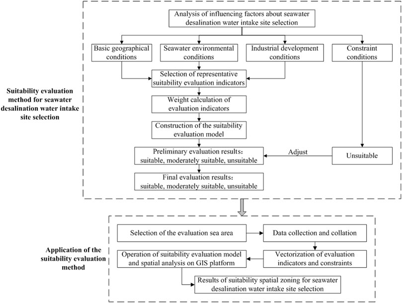
FIGURE 1. Technical flow chart for the suitability evaluation method for seawater desalination water intake site selection.
2.2 Analysis of the factors that influence seawater desalination water intake site selection
Based on the construction cost of desalination water intakes, the water demand, the stable operation of the system, and the goal of minimizing the impact on the marine ecological environment, this paper analyzes the factors that affect seawater desalination water intake site selection from four aspects: basic geographical conditions, seawater environmental conditions, industrial development conditions and various constraints (Dawoud et al., 2020).
2.2.1 Basic geographical conditions
1) Distance from coastline. The distance from the coastline to a seawater desalination water intake directly affects the capital investment in a seawater desalination project. The closer the water intake area is to the shore, the lower the cost.
2) Water depth condition. To ensure that the water intake at a seawater desalination plant is effective, a certain depth criterion must be met (Gille, 2003). Generally, sea areas with water depths greater than 2 m at the lowest tide are suitable for the construction of desalination projects of various scales. Sea areas with depths of 0–2 m are suitable for small- and medium-sized desalination projects. Sea areas with depths less than 0 m are not suitable for the construction of desalination plants (Tsiourtis, 2008).
3) Coast/sediment type. Coast types are mainly divided into bedrock coasts, sandy coasts, and muddy coasts. The engineering and geological bearing capacities of bedrock coasts are high, the underwater topography is stable, and the construction conditions are relatively good for water intake projects. The seabed foundation bearing capacity of sandy coasts is low, and the underwater topography is easily affected by waves; thus, the water intake project conditions are generally acceptable but not ideal. The foundation-bearing capacity of muddy coasts is poor, and siltation problems can be serious during excavation; notably, the construction costs are high because mechanisms are needed to prevent sediment from entering the water intake structure. The marine sediment type also affects the sediment content in a water body; thus, the sediment type is a key factor in the selection of seawater desalination water sources. Generally, gravel, sand, and clay contents in the sediment influence the effectiveness of seawater desalination, with gravel preferred over sand and clay as the least favored.
2.2.2 Seawater environmental conditions
1) Suspended sediment content. The content of suspended sediment is the main factor that influences the water intake process at seawater desalination plants. For seawater with a low suspended sediment content, complex pretreatment is generally not needed. For seawater with a high suspended sediment content, pretreatment is needed, which increases the treatment cost. According to “Seawater desalination engineering design for distillation” (Marine trade standards of China, HY/T 115-2008), the content of suspended solids in seawater entering a distillation desalination unit should be less than 50 mg/L.
2) Seawater quality. Seawater quality is one of the important factors related to the cost of desalination. The quality of seawater is related to the choice of the pretreatment method. The better the water quality is, the simpler the pretreatment process, the lower the cost, and the better the economic achievement (Elabbar and Elmabrouk, 2005; Ghosh et al., 2018; Saeed et al., 2019; Al-Kaabi et al., 2021). According to the “Technical specification for delineating source seawater protection areas for desalination” (Marine trade standards of China, HY/T 220–2017), seawater desalination water source protection areas should be established. The water quality indicators in the first-level protection areas should meet the Class II seawater quality standard (National standards of China, Sea water quality standard, GB 3097-1997), and the second-level protection areas should meet the Class III seawater quality standard.
3) Tidal current velocity. According to relevant research, to protect fish, avoid sediment entrainment, and prevent debris and other materials from becoming trapped in vortices, the maximum velocity at the seawater desalination inlet should be limited to 0.25–0.3 m/s (National standards of China, Technical guidelines for environmental impact assessment of seawater multipurpose utilization engineering, GB/T 22413-2008.). The design of water intake facilities should be controlled within this velocity range to minimize the corresponding effects.
4) Biological density. The impact of seawater desalination water intake on the marine ecological environment is mainly due to the entrainment and sweeping effect of the intake process, which reduces the quantities of larvae, juveniles, fish eggs, and plankton in adjacent local waters (Missimer and Maliva, 2018). Water intakes should be set at positions with low marine biomass and biological density to reduce the impact of water intake operations on marine organisms. The “Guidelines for marine biodiversity assessment in nearshore areas” (Marine trade standards of China, HY/T 215-2017) are used to assess the biological density.
2.2.3 Industrial development conditions
1) Distance from industrial coastline. Coastal thermal power plants, nuclear power plants, and industrial parks have high demands for seawater desalination. The closer a water intake area is to an industrial coastline, the lower the cost of desalination, and the better the economic benefit.
2) Distance from pollution sources. According to HY/T 115-2008, the location of a seawater intake should be far from pollution sources. According to the “Health management standard of centralized water supply units for desalination of drinking water” (Local standards of Shandong Province, China, DB 37/T 3683—2019), a sea area with a radius of 1,000 m around the seawater desalination water intake should not receive discharges from industrial wastewater and domestic sewage. Therefore, the farther an intake is from a pollution source, the better the water quality, and the lower the cost of desalination treatment (Tsiourtis, 2008).
3) Planning compliance. The water intake area of a seawater desalination plant should conform to regional economic and social development strategies (Tsiourtis, 2008). According to the requirements of sea area use control, the compliance categories for seawater desalination planning can be divided as follows: consistent (industrial and transportation sea areas), compatibility (fishery, tourism, and entertainment sea areas), and exclusion (special and other sea areas).
2.2.4 Constraints
For areas that are directly identified as unsuitable for the construction of desalination water intake projects, the constraints on desalination can be divided into two types: ecological constraints and status constraints.
1) Ecological constraints. Due to the impact of seawater desalination water intake projects on the marine ecological environment, important ecological areas or special protection areas are directly defined as ecological constraints. Such areas mainly include marine ecological redline areas that delimit important marine ecological function areas, ecologically sensitive areas, and ecologically vulnerable areas; important habitat areas, such as spawning grounds, feeding grounds, wintering grounds, and migration channels; and special target protection areas, such as protected areas of base points of the territorial sea. In the above areas, strict control and mandatory protection strategies must be implemented, and the construction of desalination water intake projects should be prohibited.
2) Status constraints. Island areas and reclamation areas within the scope of an evaluation are direct status constraints that may limit the construction of desalination water intake projects.
2.3 Suitability evaluation for seawater desalination water intake site selection
The suitability of seawater desalination water intake site selection refers to the suitability of a sea area for a proposed desalination water intake project considering the natural conditions and socioeconomic conditions. According to the analysis of the factors that influence seawater desalination water intake site selection, a suitability evaluation index system for seawater desalination water intake site selection is established from three aspects: basic geography, seawater environment, and industrial development. According to the relevant regulations, standards, and available information, the quantitative classification standard for every evaluation indicator is determined, and the weights of the evaluation indicators are calculated by the Analytic Hierarchy Process (AHP) (Saaty, 2008; Tang, 2021) and expert scoring method. The suitability of seawater desalination water intake site selection is evaluated by using a multifactor comprehensive evaluation model, and preliminary evaluation results are obtained. All constraints are identified as unsuitable areas, and the preliminary evaluation results are revised using these constraints to obtain the final evaluation results. The evaluation indexes and results are used to divide evaluation areas into three levels: suitable, moderately suitable, and unsuitable.
2.3.1 Establishment of the evaluation index system and quantitative classification standard
The evaluation indexes for basic geographical conditions include distance from coastline, water depth condition, and coast/sediment type. The evaluation indexes for seawater environmental conditions include suspended sediment content, seawater quality, tidal current velocity, and biological density. The evaluation indexes for industrial development conditions include distance from industrial coastline, distance from pollution sources, and planning compliance. According to the suitability of each evaluation index for seawater desalination water intake site selection, quantitative classification standards were established, as shown in Table 1.
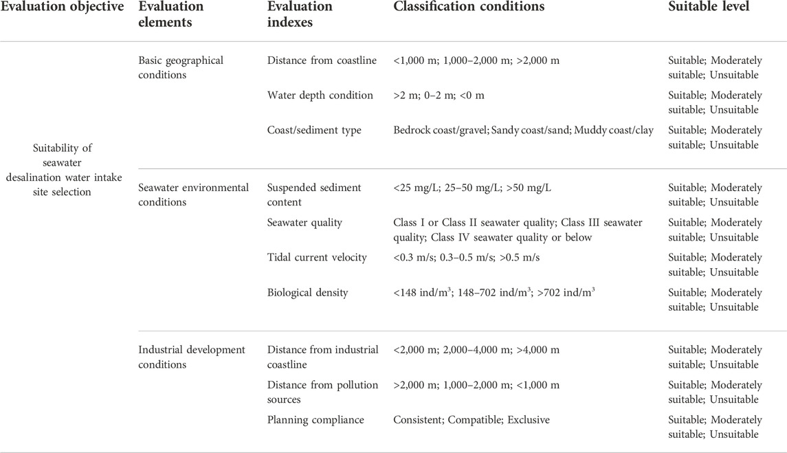
TABLE 1. Suitability evaluation index system and quantitative classification standard for seawater desalination water intake site selection.
2.3.2 Computing method for evaluation index weights
This study used the AHP combined with expert scoring to calculate the weights of the evaluation indexes (Mu and Pereyra-Rojas, 2018; Zhang et al., 2020).
First, the importance of each layer index relative to the upper layer index is determined, and the values are compared. Then, this study constructs a comparative judgment matrix
In the formula, n is the number of evaluation indexes,
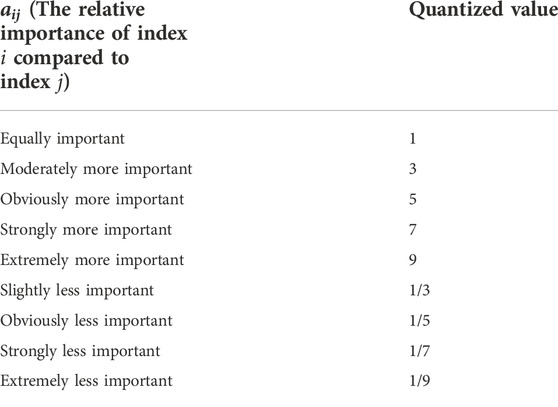
TABLE 2. The relative importance of evaluation indexes.
For the comparative judgment matrix
Where
In this study, the square root method is used to solve the regularized eigenvector and the maximum eigenvalue. First, the nth root of the product of the elements in each row of the judgment matrix
Then, the square root vector is normalized to obtain the ith component
The maximum eigenvalue
After calculating the weight of each evaluation index, it is necessary to test the consistency of the judgment matrix
In the formula,
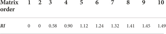
TABLE 3. RI value of average random consistency index.
When
Then, the weight values from the element layer to the target layer and from the index layer to the element layer are calculated, and a consistency test is performed:
Where
2.3.3 Suitability evaluation model
A multifactor comprehensive evaluation model is used to evaluate the suitability for seawater desalination water intake site selection:
Where S is the suitability evaluation index for seawater desalination water intake site selection;
The suitability levels of seawater desalination water intake site selection are divided into three categories: suitable, moderately suitable, and unsuitable. The evaluation results show that “suitable” refers to good economic benefit or low difficulty for the construction of desalination water intake; “moderately suitable” refers to acceptable economic benefit or moderate difficulty for the construction of desalination water intake; and “unsuitable” refers to sites that are not suitable due to constraints or for which the construction of water intake is difficult or not economical.
3 Application of the suitability evaluation method and discussion
3.1 Overview of the study area
Rongcheng city is located in the easternmost part of Shandong Province in China, between east longitudes 122° 08′ to 122° 42′ and north latitudes 36° 45′ to 37° 27′. The city is surrounded by the Yellow Sea to the north, east, and south. The area has a warm and humid temperate continental monsoon climate. Rongcheng city lacks freshwater because it is surrounded by seas on three sides. Recent years have seen the continuous development of industries, industrial parks, and economic and technological development zones in Rongcheng city, and the dependence on freshwater resources has increasingly risen. The freshwater resource shortage problem must urgently be solved with seawater desalination.
The coastline of Rongcheng city is tortuous, with 10 bays and 72 islands distributed along the coast, belonging to the bedrock harbor-type coast. The water quality of the Rongcheng offshore area has reached the national class II standard or above. The coast of Chengshan town in Rongcheng city is the wintering habitat of swans, and a Rongcheng swan national nature reserve has been established to protect swans and other rare and endangered birds. In addition, to protect the marine ecosystem of Chengshantou and all base points of the territorial sea in Rongcheng city, Chengshantou nature reserve and protected areas have been established around the base points of the territorial sea. Three marine fishing grounds near Rongcheng city have been named Yanwei, Shidao, and Lianqingshi. They are the primary means by which many kinds of fish and shrimp migrate. They are rich in aquatic resources and have marine pastures in Sanggou Bay and Ailian Bay.
In this paper, the coastal area of Rongcheng city is selected to perform applied research on the suitability evaluation method for selecting the spatial location for seawater desalination water intakes. The coastline extracted from remote sensing images in 2019 is taken as the landside boundary. The main coast is extended 5 km outward to create the seaside boundary. On both sides, the administrative boundary of the Rongcheng sea area approved by the State Council is used as another boundary; it starts from Maozicaokou at the junction of Boyu town, Huancui District, Weihai city in the north and ends at Caiguan estuary near Wendeng city in the south. The length of the coastline within the evaluation scope is 493.2 km, and the area of the evaluation scope is 1,049.7 km2, as shown in Figure 2.
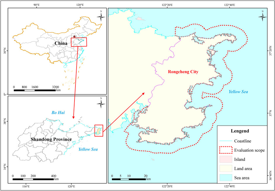
FIGURE 2. Study area and evaluation scope.
3.2 Evaluation process and results
3.2.1 Data sources and processing methods
According to the suitability evaluation index system and quantitative classification standard for seawater desalination water intake site selection constructed in Table 1, when carrying out sustainability evaluation in Rongcheng city, it is necessary to obtain the spatial distribution data of each evaluation index within the evaluation scope. Due to the large extent of the study area, this study cannot simultaneously obtain the latest survey data of all evaluation indicators. However, the suitability evaluation for seawater desalination water intake site selection focuses on the spatial distribution difference of each evaluation index. The data content of these evaluation indexes is different, and different indexes will not affect each other. Moreover, the spatial distribution of many evaluation indexes, such as coast/sediment type, water depth condition, tidal current velocity, and other evaluation indexes, does not change much with time. For each evaluation index, this study collected the latest survey data and information as much as possible, but there are still some data from earlier years. However, these data meet the needs of suitability evaluation for seawater desalination water intake site selection and ensure the accuracy of evaluation results in Rongcheng city. The data sources of this study mainly include coastline survey data of Rongcheng city in 2020, survey data of the Shandong coastal zone in 2018, hydrological observation data of Rongcheng coastal waters in 2018, the marine environment status bulletin of Rongcheng city in 2017, ecological survey data of Rongcheng coastal waters in 2016, the China Electronic Chart (Rongcheng sea area, chart No. C1412110), Rongcheng sea area use planning data (planning period: 2013–2020). See Table 4 for the detailed processing method of the original data and the corresponding evaluation index data obtained. The classification conditions of all evaluation indexes adopt the classification standard in Table 1.

TABLE 4. Data sources and processing methods.
3.2.2 Suitability evaluation for seawater desalination water intake site selection
The suitability evaluation of seawater desalination water intake site selection requires spatial analysis and calculations involving large quantities of spatial data; thus, a GIS platform with spatial data management and spatial analysis functions is used. The ArcToolbox in ArcGIS software (developed by ESRI Company, United States) provides many directly usable spatial data processing tools. Therefore, ArcGIS software was selected as the platform for the suitability evaluation of seawater desalination water intake site selection. In this study, all the layers adopt the China Geodetic Coordinate System 2000 (CGCS 2000), the Gauss-Kruger projection, a central longitude of 123°, and a grid data resolution of 50 m. The scope of all evaluation index layers is consistent with the evaluation scope.
1) Layering the evaluation indexes
ArcGIS software uses layers for the spatial analysis and processing of spatial data. Data were collected and used to create GIS layers, including vector and grid layers, which represent the spatial distribution information for each evaluation index. The data sources and data processing methods for each evaluation index are shown in Table 4. The classification conditions of all evaluation indexes adopt the classification standard in Table 1. When carrying out suitability evaluation on the ArcGIS platform, it is necessary to run the multifactor spatial overlay analysis tool. The tool requires that all evaluation index layers be grid layers with the same spatial range and spatial resolution. Therefore, all the vector layers should be converted to grid layers. The suitable levels “suitable”, “moderately suitable” and “unsuitable” for each evaluation index were represented by suitability scores of 2, 1, and 0, respectively.
For distance-type indicators, such as “distance from coastline”, “distance from industrial coastline” and “distance from pollution sources”, first, the Euclidean distance tool was used to generate a distance grid layer. Then, the grid layer was reclassified according to the index classification conditions to generate a grid layer based on the suitability score. For other indicators, such as “water depth condition”, “coastal/sediment type” and “suspended sediment content”, first, the polygon vector layer was generated according to the classification conditions. Then, the suitability score attribute was added, and the polygon vector layer was converted to a raster layer according to the suitability score. After the above spatial analysis and processing steps, grid layers of each evaluation index with the same spatial range and grid resolution were obtained, as shown in Figure 3.

FIGURE 3. The suitable level of evaluation indicators.
2) Calculation of the weights of evaluation indexes
This study used the AHP combined with expert scoring to calculate the weights of the evaluation indexes. Twenty-five experts in seawater desalination, environmental science, marine science, and related fields were consulted regarding the relative importance of each element layer and index layer in Table 1 for the suitability evaluation index system for seawater desalination water intake site selection. We considered the suggestions of these experts comprehensively. The quantitative judgment results are shown in Tables 5–8. Additionally, the calculated evaluation index weights are shown in Table 9.
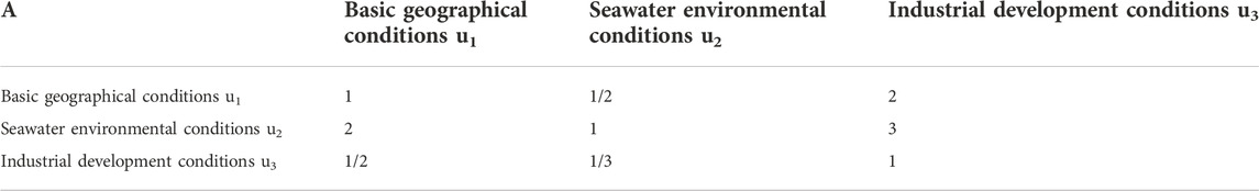
TABLE 5. Quantitative judgment of the relative importance of the element layer.
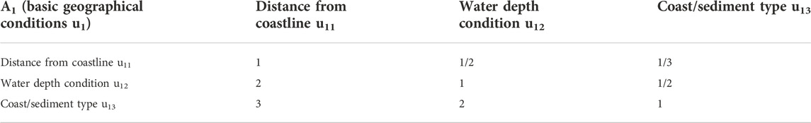
TABLE 6. Quantitative judgment of the relative importance of indexes for basic geographical conditions.
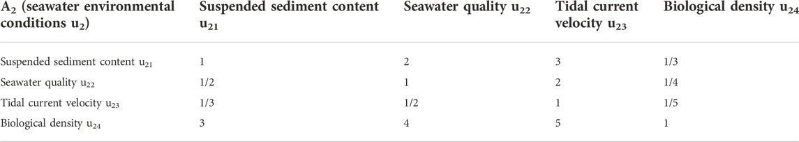
TABLE 7. Quantitative judgment of the relative importance of indexes for seawater environmental conditions.

TABLE 8. Quantitative judgment of the relative importance of indexes for industrial development conditions.
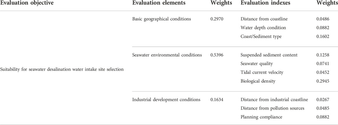
TABLE 9. Weight calculation results for the evaluation indexes.
3) Implement the evaluation model
The multifactor spatial overlay analysis (weighted sum) tool was used on the ArcGIS platform to perform weighted overlap calculations. Each evaluation index raster layer and its corresponding weight value were input, and each pixel in the output raster layer was the result of the overlap addition operation for all evaluation index layers. This value was a single-precision value between 0 and 2. The raster layer was reclassified according to the classification conditions of 0–1 for unsuitable, 1–1.3 for moderately suitable, and 1.three to two for suitable. Then, this layer was converted to a vector polygon layer (raster to polygon) to obtain preliminary spatial zoning of the suitability for seawater desalination water intake site selection. There were three types of suitable spatial zones, namely “suitable areas”, “moderately suitable areas” and “unsuitable areas”, as shown in Figure 4 (left figure).
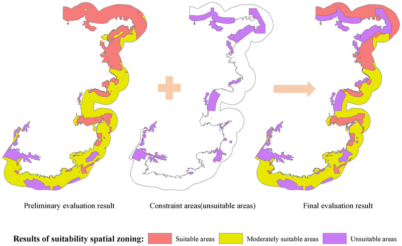
FIGURE 4. The results of suitability spatial zoning.
3.2.3 Obtain the vector layer for the constraint regions
As mentioned above, the constraints on desalination can be divided into two types: ecological constraints and status constraints. The ecological restraint areas in Rongcheng city mainly include marine ecological redline areas, such as the Whooper swans marine nature reserve, Chengshantou marine ecosystem nature reserve, and Sanggouwan nature reserve, and the protected areas around the five base points of territorial sea in Rongcheng city, including Shandong Gaojiao (1), Shandong Gaojiao (2), Moye Island (1), Moye Island 2) and Moye Island (3). The status constraint areas in Rongcheng city mainly include reclamation areas and island land areas, such as Jiming Island, Moye Island, and Hailu Island, within the assessment scope obtained by vectoring remote sensing images. The ecological constraints and status constraints in Rongcheng city were merged into a vector layer of constraints, identified as directly unsuitable areas, as shown in Figure 4 (middle figure).
3.2.4 Obtain the final evaluation results
In the preliminary spatial zoning for the suitability of seawater desalination water intake site selection, all areas that overlapped with the vector layer generated using the above constraints were adjusted to unsuitable areas, regardless of their original types. After correction, the final suitability spatial zoning for seawater desalination water intake site selection was obtained. The final evaluation results for seawater desalination water intake site selection were also divided into three categories, namely “suitable areas”, “moderately suitable areas” and “unsuitable areas”, as shown in Figure 4 (right figure).
The final evaluation results show that “suitable areas” refers to good economic benefit or low difficulty for the construction of desalination water intake; “moderately suitable areas” refers to acceptable economic benefit or moderate difficulty for the construction of desalination water intake; and “unsuitable areas” refers to sites that are not suitable due to constraints or for which the construction of water intake is difficult or not economical.
3.2.5 Analysis and discussion
According to the suitability evaluation spatial zoning for seawater desalination water intake site selection, statistics were obtained considering the sea area and coastline length for three levels: suitable, moderately suitable, and unsuitable. The results are shown in Table 10. From the perspective of the occupied sea area, the suitable sea area is 304.8 square kilometers, accounting for 29% of the total region. Such suitable areas are mainly distributed in the offshore waters north of Rongcheng city, with continuous large patches; suitable areas in the central waters are mainly located near the coast, with medium-sized zones, and suitable areas in the southern seas are mainly located near the coastline, with small zones. The moderately suitable sea area is 452.5 square kilometers, accounting for 43% of the total region, and such areas are mainly distributed in the central and southern waters of Rongcheng city. The unsuitable sea area is 292.4 square kilometers, accounting for 28% of the total region, and such areas are mainly distributed in the marine ecological redline area near the northern coast of Rongcheng city and the marine aquaculture area near the Qinglong River mouth in the south.
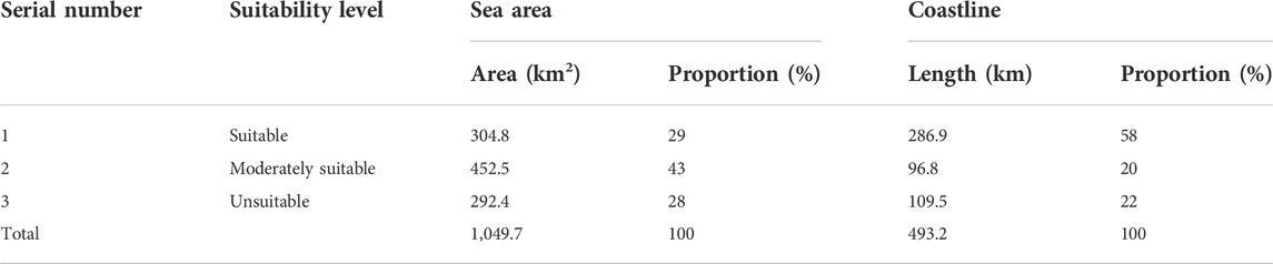
TABLE 10. Statistics for the Rongcheng offshore area evaluation results.
In terms of the length of the coastline occupied, the suitable coastline length is 286.9 km, accounting for 58% of the total coastline length, which is mainly located along the central and southern coastlines of Rongcheng city. The moderately suitable coastline length is 96.8 km, accounting for 20% of the total coastline length, which is mainly distributed along the central coastline of Rongcheng city. The length of the unsuitable coastline is 109.5 km, accounting for 22% of the total coastline length, which is mainly distributed along the coastlines of the marine ecological redline area and the coastal aquaculture area in Rongcheng city.
Rongcheng is a city short of water. As it is surrounded by the sea on three sides and lacks freshwater sources, the excavation of groundwater will cause seawater to recharge. In previous years, affected by drought and water shortages, many enterprises were in a state of shutdown or semi-shutdown. To ensure social stability and the minimum domestic water needs for residents, it is urgent to use the local rich seawater resources for desalination and implement the seawater desalination project to ensure the normal water supply in Rongcheng city. Therefore, a suitability evaluation of this area for seawater desalination water intake site selection is of great significance. The seawater desalination water intake project of the Shidao Bay nuclear power plant built in Rongcheng city is located in suitable areas for the suitability evaluation results, which shows the effectiveness and feasibility of the suitability evaluation method for seawater desalination water intake site selection in this study.
In the future, consideration should be given to the development and utilization strategies in Rongcheng city and the spatial distribution of resources, as its southern waters are dominated by traditional fish farming and support aquatic product processing, shipbuilding, fishing ports, and wharf construction; these waters are mainly industrially-oriented. The northern waters are mainly used for tourism development and utilization, with a general preference for protection and development. The eastern part of the area includes fishery, industry, and tourism functions and is in a state of balanced protection and development. In general, the southern and eastern parts of Rongcheng city urgently need freshwater; with the exception of the Qinglong Estuary, which is unsuitable for desalination sites, most areas are suitable and moderately suitable for seawater desalination water intake site selection. The low demand for fresh water in the northern region has much to do with the protective development strategy in this area, with an emphasis on tourism; hence, most of these areas are unsuitable for desalination.
4 Conclusion
In this study, the influencing factors of seawater desalination water intake site selection are analyzed from four aspects: basic geographical conditions, water environmental conditions, industrial development conditions, and constraint conditions. Representative evaluation indicators, such as distance from coastline, water depth condition, suspended sediment content, seawater quality, and planning compliance are selected, and the quantitative classification standards of each evaluation indicator are determined according to relevant standards, specifications, and research basis. The suitability evaluation model of seawater desalination water intake site selection is constructed based on the GIS platform, and the suitability spatial zoning results are generated by multifactor spatial superposition analysis and correction by constraints. The research results improve the existing spatial location selection and planning method for seawater desalination intake from the theoretical method and technical level and form an evaluation system with scientific, quantitative, and spatial characteristics, which can provide research ideas and technical support for the spatial location selection of seawater desalination intake.
The suitability evaluation system for seawater desalination water intake site selection constructed in this study has perfect methods, comprehensive evaluation indicators, a simple construction process, efficient operation, strong operability, and universality, which can be popularized and applied in the spatial selection for seawater desalination water intakes. The suitability evaluation method has been applied in the coastal waters of Rongcheng city, Shandong Province, China. In this application, based on the impact analysis of three evaluation elements on seawater desalination water intake site selection, the impact of seawater environmental conditions is the largest, followed by the impact of basic geographical conditions, and the impact of industrial development conditions is the smallest; the evaluation element weights are 0.5396, 0.2970, and 0.1634 respectively. Based on the impact analysis of evaluation indexes on seawater desalination water intake site selection, the evaluation indexes with greater impact are biological identity, coast/sediment type, and suspended sediment content; the evaluation index weights are 0.2945, 0.1602, and 0.1258 respectively. The evaluation indexes with less impact are distance from industrial coastline, tidal current velocity, and distance from pollution sources; the evaluation index weights are 0.0267, 0.0452, and 0.0485 respectively. The evaluation results conform to the natural and socioeconomic characteristics of Rongcheng city and meet the needs for seawater desalination water intake site selection in Rongcheng city.
The results show that the evaluation method has a strong scientific nature, applicability, and operability and can better meet the needs of practical applications. When applying this suitability evaluation method in other coastal areas, according to the local natural environment characteristics and socioeconomic development needs, and in combination with the availability of spatial data, the evaluation indicators can be appropriately increased or decreased, and the quantitative classification standards of the evaluation indicators can be adjusted. The weight calculation of the evaluation indicators and the classification of the evaluation results can be set according to the local status and needs, and then the suitability evaluation method for seawater desalination water intake site selection can be established to meet these requirements while being further improved and optimized throughout the application process.
Data availability statement
The data analyzed in this study is subject to the following licenses/restrictions: This is the application dataset for a Chinese region. Requests to access these datasets should be directed to Pei Huang, hp@fio.org.cn.
Author contributions
PH: Data acquisition, constructing the suitable evaluation index system, writing original draft, making maps. YS: Data acquisition, constructing the suitable evaluation index system. DG: Data acquisition, constructing the suitable evaluation index system. WY: Constructing the suitable evaluation index system. YC: Constructing the suitable evaluation index system. EW: Data acquisition.
Funding
This study was funded by the National Key Research and Development Program of China (2018YFC0408001).
Conflict of interest
The authors declare that the research was conducted in the absence of any commercial or financial relationships that could be construed as a potential conflict of interest.
Publisher’s note
All claims expressed in this article are solely those of the authors and do not necessarily represent those of their affiliated organizations, or those of the publisher, the editors and the reviewers. Any product that may be evaluated in this article, or claim that may be made by its manufacturer, is not guaranteed or endorsed by the publisher.
References
Ahmad, N. A., Goh, P. S., Yogarathinam, L. T., Zulhairun, A. K., and Ismail, A. F. (2020). Current advances in membrane technologies for produced water desalination. Desalination 493, 114643. doi:10.1016/j.desal.2020.114643
Ahmed, F. E., Hashaikeh, R., and Hilal, N. (2020). Hybrid technologies: The future of energy efficient desalination – a review. Desalination 495, 114659. doi:10.1016/j.desal.2020.114659
Al-Kaabi, A., Al-Sulaiti, H., Al-Ansari, T., and Mackey, H. R. (2021). Assessment of water quality variations on pretreatment and environmental impacts of SWRO desalination. Desalination 500, 114831. doi:10.1016/j.desal.2020.114831
Al-Kaabi, A. H., and Mackey, H. R. (2019). Environmental assessment of intake alternatives for seawater reverse osmosis in the Arabian Gulf. J. Environ. Manage. 242, 22–30. doi:10.1016/j.jenvman.2019.04.051
Andrianne, J. A., and Ftlix, A (2004). Desalination site selection on North-African coasts. Desalination 165, 231–239. doi:10.1016/s0011-9164(04)00267-x
Aydin, F., and Sarptas, H. (2019). Spatial assessment of site suitability for solar desalination plants: A case study of the coastal regions of Turkey. Clean. Technol. Environ. Policy 22 (2), 309–323. doi:10.1007/s10098-019-01783-0
Darwish, M. A., Abdulrahim, H. K., Hassan, A. S., and Shomar, B. (2016). Reverse osmosis desalination system and algal blooms part II: Seawater intake technologies. Desalination Water Treat. 57 (54), 25881–25917. doi:10.1080/19443994.2016.1159619
Dawoud, O., Ahmed, T., Abdel-Latif, M., and Abunada, Z. (2020). A spatial multi-criteria analysis approach for planning and management of community-scale desalination plants. Desalination 485, 114426. doi:10.1016/j.desal.2020.114426
Díaz, H., Loughney, S., Wang, J., and Guedes Soares, C. (2022). Comparison of multicriteria analysis techniques for decision making on floating offshore wind farms site selection. Ocean. Eng. 248, 110751. doi:10.1016/j.oceaneng.2022.110751
Divu, D. N., Mojjada, S. K., Pokkathappada, A. A., Sukhdhane, K., Menon, M., Mojjada, R. K., et al. (2021). Decision-making framework for identifying best suitable mariculture sites along north East Coast of arabian sea, India: A preliminary GIS-MCE based modelling approach. J. Clean. Prod. 284, 124760. doi:10.1016/j.jclepro.2020.124760
Eke, J., Yusuf, A., Giwa, A., and Sodiq, A. (2020). The global status of desalination: An assessment of current desalination technologies, plants and capacity. Desalination 495, 114633. doi:10.1016/j.desal.2020.114633
Elabbar, M. M., and Elmabrouk, F. A. (2005). Environmental impact assessment for desalination plants in Libya. Case study: Benghazi North and Tobrouk desalination plants. Desalination 185 (1-3), 31–44. doi:10.1016/j.desal.2005.02.074
Elabbar, M. M. (2008). The Libyan experimental on the environmental impact assessment for desalination plants. Desalination 220 (1-3), 24–36. doi:10.1016/j.desal.2007.01.020
Elsaid, K., Kamil, M., Sayed, E. T., Abdelkareem, M. A., Wilberforce, T., and Olabi, A. (2020). Environmental impact of desalination technologies: A review. Sci. Total Environ. 748, 141528. doi:10.1016/j.scitotenv.2020.141528
Flocard, F., Ierodiaconou, D., and Coghlan, I. R. (2016). Multi-criteria evaluation of wave energy projects on the south-east Australian coast. Renew. Energy 99, 80–94. doi:10.1016/j.renene.2016.06.036
Ghosh, P. K., Akber, M. A., and Islam, M. A. (2018). Water quality of small-scale desalination plants in southwest coastal Bangladesh. Water Supply 18 (5), 1606–1616. doi:10.2166/ws.2017.222
Gille, D. (2003). Seawater intakes for desalination plants. Desalination 156, 249–256. doi:10.1016/s0011-9164(03)00347-3
Glueckstern, P. P., M., and Priel, M. (2003). Potential cost reduction of seawater desalination. Water Supply 3, 39–47. doi:10.2166/ws.2003.0148
Huang, J. J. (2021). Analytic hierarchy process with the correlation effect via WordNet. Mathematics 9 (8), 872. doi:10.3390/math9080872
Jha, D. K., Pandey, V., Santhanakumar, J., Sathish Kumar, P., Venkatnarayanan, S., Jebakumar, J. P. P., et al. (2022). Evaluation of site suitability for artificial reefs deployment in southeast coast of India using geographical information system as a management tool. Front. Mar. Sci. 8, 817975. doi:10.3389/fmars.2021.817975
Kreshman, S. A. (1985). Seawater intakes for desalination plants in Libya. Desalination 55, 493–502. doi:10.1016/0011-9164(85)80093-x
Lin, S., Zhao, H., Zhu, L., He, T., Chen, S., Gao, C., et al. (2021). Seawater desalination technology and engineering in China: A review. Desalination 498, 114728. doi:10.1016/j.desal.2020.114728
Liu, F., Peng, Y., Zhang, W., and Pedrycz, W. (2017). On consistency in AHP and fuzzy AHP. J. Syst. Sci. Inf. 5 (2), 128–147. doi:10.21078/jssi-2017-128-20
Marsh, P., Penesis, I., Nader, J. R., and Cossu, R. (2021). Multi-criteria evaluation of potential Australian tidal energy sites. Renew. Energy 175, 453–469. doi:10.1016/j.renene.2021.04.093
Missimer, T. M., and Maliva, R. G. (2018). Environmental issues in seawater reverse osmosis desalination: Intakes and outfalls. Desalination 434, 198–215. doi:10.1016/j.desal.2017.07.012
Morton, A. J., Callister, I. K., and Wade, N. M. (1996). Environmental impacts of seawater distillation and reverse osmosis processes. Desalination 108, 1–10. doi:10.1016/s0011-9164(97)00002-7
Mu, E., and Pereyra-Rojas, M. (Editors) (2018). “Group decision-making in AHP,” in Practical decision making using super decisions v3: An Introduction to the Analytic Hierarchy Process. Cham: Springer International Publishing, 81–89. doi:10.1007/978-3-319-68369-0_8
Ramírez, Y., Kraslawski, A., and Cisternas, L. A. (2019). Decision-support framework for the environmental assessment of water treatment systems. J. Clean. Prod. 225, 599–609. doi:10.1016/j.jclepro.2019.03.319
Saaty, T. L. (2008). Decision making with the analytic hierarchy process. Int. J. Serv. Sci. 1 (1), 83–98. doi:10.1504/ijssci.2008.017590
Saeed, M. O., Al-Nomazi, M. A., and Al-Amoudi, A. S. (2019). Evaluating suitability of source water for a proposed SWRO plant location. Heliyon 5 (1), e01119. doi:10.1016/j.heliyon.2019.e01119
Shahabi, M. P., McHugh, A., Anda, M., and Ho, G. (2017). A framework for planning sustainable seawater desalination water supply. Sci. Total Environ. 575, 826–835. doi:10.1016/j.scitotenv.2016.09.136
Stelzenmüller, V., Gimpel, A., Gopnik, M., and Gee, K. (2017). “Aquaculture site-selection and marine spatial planning the roles of GIS-based tools and models,” in Aquaculture perspective of multi-use sites in the open ocean: The Untapped Potential for Marine Resources in the Anthropocene. Editors B. H. Buck, and R. Langan (Cham: Springer International Publishing), 131–148. doi:10.1007/978-3-319-51159-7_6
Tang, J. (2021). Prioritizing user requirements based on analytic hierarchy process. J. Phys. Conf. Ser. 1861, 012021. doi:10.1088/1742-6596/1861/1/012021
Tekin, S., Guner, E. D., Cilek, A., and Unal Cilek, M. (2021). Selection of renewable energy systems sites using the MaxEnt model in the Eastern Mediterranean region in Turkey. Environ. Sci. Pollut. Res. 28 (37), 51405–51424. doi:10.1007/s11356-021-13760-6
Tsiourtis, N. X. (2008). Criteria and procedure for selecting a site for a desalination plant. Desalination 221 (1-3), 114–125. doi:10.1016/j.desal.2007.01.073
Wei, B., Li, Y., Suo, A., Zhang, Z., Xu, Y., and Chen, Y. (2021). Spatial suitability evaluation of coastal zone, and zoning optimisation in ningbo, China. Ocean Coast. Manag. 204, 105507. doi:10.1016/j.ocecoaman.2020.105507
Yin, S., Takeshige, A., Miyake, Y., and Kimura, S. (2018). Selection of suitable coastal aquaculture sites using multi-criteria decision analysis in Menai Strait, UK. Ocean Coast. Manag. 165, 268–279. doi:10.1016/j.ocecoaman.2018.08.022
Yusefi, F., Zahedi, M. M., and Ziyaadini, M. (2021). Evaluation for the optimization of two conceptual 200, 000 m3/day capacity RO desalination plant with different intake seawater of Oman Sea and Caspian Sea. Appl. Water Sci. 11, 12. doi:10.1007/s13201-020-01338-5
Keywords: seawater desalination, water intake site selection, suitability evaluation, quantitative, spatial zoning
Citation: Huang P, Sun Y, Gu D, Yan W, Chen Y and Wang E (2022) Quantitative suitability evaluation and spatial zoning for seawater desalination water intake site selection. Front. Environ. Sci. 10:842253. doi: 10.3389/fenvs.2022.842253
Received: 23 December 2021; Accepted: 04 November 2022;
Published: 18 November 2022.
Edited by:
Paolo Perona, Swiss Federal Institute of Technology Lausanne, SwitzerlandReviewed by:
Marwa Elkatory, City of Scientific Research and Technological Applications, EgyptMurat Eyvaz, Gebze Technical University, Turkey
Copyright © 2022 Huang, Sun, Gu, Yan, Chen and Wang. This is an open-access article distributed under the terms of the Creative Commons Attribution License (CC BY). The use, distribution or reproduction in other forums is permitted, provided the original author(s) and the copyright owner(s) are credited and that the original publication in this journal is cited, in accordance with accepted academic practice. No use, distribution or reproduction is permitted which does not comply with these terms.
*Correspondence: Yonggen Sun, c3lnQGZpby5vcmcuY24=