 Shengjun Xiao
 Lin Yi2
 Huiyu Liu
 Zhaoyuan Yu
- 1School of Geography, Nanjing Normal University, Nanjing, China
- 2College of Earth Sciences, Chengdu University of Technology, Chengdu, China
- 3Faculty of Geomatics, Lanzhou Jiaotong University, Lanzhou, China
Considering the embarrassments related to inadequate safety monitoring detection and chaotic development order during the current ecological development of coastal tidal mudflat, we put forward a remote sensing image-based comprehensive monitoring detection platform integrating image data acquisition, mechanism analysis, comprehensive evaluation, and intelligent monitoring detection for coastal tidal mudflat ecological development. The platform includes imaging and data fusion technology, comprehensive evaluation and spatial layout optimization technology, and dynamic safety monitoring and early warning technology. A case study on Dafeng coastal tidal mudflat was conducted. The results show that our research can provide substantial reference for the coordination, dynamic management, and comprehensive regulation for the ecological development of coastal tidal mudflat.
1 Introduction
The ecosystem of coastal tidal mudflat is characterized by diversification in influencing element, complex processes, strong environmental sensitivity, and vulnerability and has a wide range of impacts derived from multiple channels (Turner, 2000; Dauvin, 2008; Wang, 2013). The existing development process for coastal tidal mudflat has many problems, such as the chaotic development pattern, the lack of comprehensive integration, and dynamic monitoring (Zhao et al., 2009; Liang et al., 2011). Furthermore, high-intensity development has also led to the aggravation of regional habitat destruction, biodiversity reduction, pollution, and resource degradation (Paoli et al., 2008; Hua et al., 2012). Considering the rational and coordinated development for coastal tidal mudflat, a batch of investigators have carried out multidimensional studies on the aspects of the comprehensive investigation and management of coastal tidal mudflat, relevant monitoring methods and technologies, analysis models and evaluation systems, regulation mechanisms and early warning platforms, etc. (Lee, 1999; Wang and Zou, 2009). With the transformation from an early single-objective management to a multi-objective, multi-scale, and multilevel coordinated and unified comprehensive management in coastal zones (Zhang, 1999; Pickaver et al., 2004; Hou et al., 2005), multiple elements including ecological, environmental, population, social, economic, and legal factors should also be considered in the dynamic regulation of coastal tidal mudflat. Under the constraints of ecology, environment, security, and other comprehensive factors, high-precision and high-resolution dynamic continuous monitoring of the development process should be realized, and the spatiotemporal pattern characteristics and dynamic evolution mechanism of coastal tidal mudflat should also be explored so as to carry out suitability evaluation for ecological development (Brommer and Bochev-van der Burgh, 2009; Li et al., 2011; Harvey et al., 2012). In view of urgent requirement for environmental safety and economic development, dynamic monitoring, evaluation, and regulation analysis in the development process of coastal tidal mudflat should be appreciated and the transformation from traditional static management to dynamic comprehensive monitoring detection should be realized (Zhang, 1999; Henocque, 2003; Wang and Li, 2006). Besides the community of scholars, supervision departments of government also emphasized on the trend that the management method of coastal ecosystem should transform to dynamic management and comprehensive regulation (Long et al., 2016).
Currently, there are many reports on land use monitoring detection platform, such as the mobile law enforcement and online analysis (Chen et al., 2009), regional land information-integrated management model (RLI2M) (Zhu and Huang, 2010), post-processing monitoring for land use (Xu et al., 2010), and “one map” for the land resources (Zhang, 2010). Despite these, there is still a lack of system platform that can support the integrated management and integration of ecology, environment, land, society, and economy, in terms of comprehensive monitoring detection of ecological development in coastal tidal mudflat. Moreover, the existing platforms of information management for coastal tidal mudflat are mostly targeted at a single-user group, therefore, lacking the cooperative participation management mechanism between the public and government departments and industries. It is necessary to construct the comprehensive coordinated information dynamic management mode of coastal zones with multi-scale, multi-objective and multilevel, in order to develop the information management of coastal tidal mudflat from the single-field to multi-field comprehensive open service stage. Subsequently, the network sharing intelligent regulation and real-time warning mechanism driven by the analysis results of the coupling effect and evolution law need to be formed (Liu et al., 2017; Zhang et al., 2021). Finally, a dynamic monitoring detection system and platform should be established to support the demand of mass data transmission, scheduling and analysis, realize the comprehensive integration of monitoring detection system and business process, dynamically supervise the development process of coastal tidal mudflat, and comprehensively coordinate the interests of all parties.
Based on the research approach of “data acquisition–process mechanism–comprehensive evaluation–intelligent monitoring detection,” we constructed a technical system for the comprehensive supervision of ecological development of coastal tidal mudflat. Furthermore, we designed a comprehensive analysis model, involving a business process-driven data collection and integration system, security evaluation of coastal tidal mudflat ecological development, identification and analysis of sensitivity factors of ecological security, and the landscape optimization method of coastal tidal mudflat ecological development. Based on the this, a system platform for comprehensive supervision of coastal tidal mudflat development was further put forward. Our study aims to break through the traditional single-perspective and single-objective framework, realizing the conversion from the management mode based on remote sensing resources monitoring and summary evaluation to the intelligent management mode based on internal driving mechanism mining and simulation reasoning research. Finally, an integrated monitoring and analysis platform with multi-scale, multi-objective, multilevel, and comprehensive research was constructed.
2 Methods
2.1 Research Scheme of Detection Platform for Ecological Development
It is of great significance to establish an information monitoring detection platform on coastal tidal mudflat development for realizing overall coordination, dynamic management, and comprehensive control of the ecological development process of coastal tidal mudflat (Christensen et al., 2008). In view of the demand for comprehensive supervision of the ecological development of coastal tidal mudflat, the comprehensive supervision of coastal tidal mudflat needs to integrate the data of multisource coastal tidal mudflat ecological environment and the current situation of development and utilization. From the perspective of coordinated development of resources, environment, industrial development, population, and output, the comprehensive evaluation index system and evaluation model for the ecological development of coastal shoal flats were established. Based on the this, we can identify the different development modes such as the stress index, ecological environment influence mechanism, analysis of the ecological development of safety factors, and different types of tidal flat-suitable development intensity, and solve the different development needs and constraints, to establish an ecology suitable for the coastal shoal development of the early warning and decision-making mechanism.
Based on methods mentioned previously, the ideas for constructing the monitoring detection platform for the ecological development of coastal tidal mudflat are shown in Figure 1. With respect to the conceptual design, it is mainly guided by the national coastal development strategy, marine spatial planning, and ecological management and based on the development concepts of ecological development, sustainable development, pattern optimization, and security development. The research is based on multilevel, high-resolution, and high-precision status perception systems and data analysis technology, comprehensive evaluation technology of coastal tidal mudflat ecological development, analysis technology of the coastal tidal mudflat development process and mechanism, and optimization technology of the spatial layout of coastal tidal mudflat ecological development and utilization. Subsequently, through the setting and implementation of relevant data standards, standardization, business processes, and analysis models, the system implementation and business integration of the aforementioned key technologies were carried out, and a comprehensive monitoring detection platform for the ecological development of coastal tidal mudflat was finally formed.
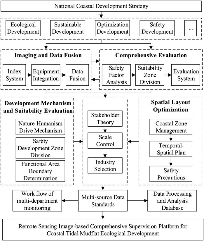
FIGURE 1. Research scheme of ecological development and monitoring detection of coastal tidal mudflat.
2.2 Platform Architecture and Functional System
Based on the existing research results, we summarized the general ideas for establishing a comprehensive coordination and comprehensive monitoring detection platform for the ecological development of coastal tidal mudflat. To be specific, it is the path of differentiation, evolution, and reconfiguration of the goal of comprehensive monitoring detection. This process is similar to the continuous division of human embryonic cells in the process of gestation, differentiation into skin, viscera, bone, hair, and other different directions of evolution of the basic cells, each of the basic cells independently evolving into a fully functional organ, and finally all organs work together to form a complete human body. Concretely, the differentiation refers to the process of decomposing various business units of comprehensive supervision based on the boundaries of various business objectives involved in comprehensive supervision; evolution refers to the process of further development and strengthening of the functions of individual business units; and reconstruction refers to the process of coordination and integration of fully evolved business units on a unified platform. Among them, the evolution process of larger and more complex business units can be divided into the process of differentiation, evolution, and reconstruction. Through the nesting and iteration of this process, the construction of a comprehensive regulatory platform can be realized through the coupling of layers of underlying technologies. Underlying technologies with repeatability or generality need to be implemented only once, while functional implementations with expertise can evolve independently. Compared with the construction of the traditional monitoring detection platform for individual businesses, the functions and objectives of a specific business can be realized in the comprehensive monitoring detection platform, but its realization process relies on the power of the comprehensive monitoring detection platform to mobilize other functions. Overall, there are two advantages to this approach. First, the implementation of a single business can focus more on its essence, eliminating the construction of functions supporting its operation. Second, each business can be made compatible with the platform and presented in a unified, comprehensive, and coordinated way.
According to the dynamic monitoring detection requirements of the ecological development process and business of coastal tidal mudflat, a dynamic monitoring and early warning platform system of coastal tidal mudflat development was constructed based on service-oriented architecture (SOA) and component-based development ideas (Figure 2). Due to the problems of data decentralization and ineffective cooperative supervision in multi-department management before, during, and after the ecological development of coastal tidal mudflat, it is necessary to base on the idea of “one map” for coastal areas. Based on the business flow model, module development, and network development technology, the comprehensive regulatory business process of coastal resource security-influencing factor (natural disasters, shoreline changes, and reclamation project security) supervision, development process monitoring and detection, business monitoring and detection, and forecast and early warning were studied. Then, a comprehensive monitoring detection platform for information visualization of coastal beach ecological development was developed, which integrates on-site monitoring, comprehensive information management, decision and early warning supports, and network sharing for coastal beach ecological development. In addition, we have also realized the network space information dissemination and formed a visual and comprehensive monitoring detection system that integrates on-site monitoring, integrated information management, decision and early warning supports, and network sharing. We finally achieved the goal of fast, real-time, and dynamic supervision of “painting by drawing pipe and dynamic monitoring.”
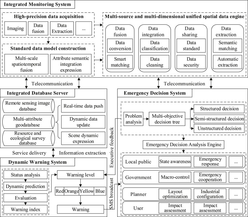
FIGURE 2. Functional system of the dynamic monitoring and warning platform for ecological development, monitoring and detection of coastal tidal mudflat.
2.3 Key Technologies
The comprehensive monitoring detection platform is composed of three subsystems: stereo monitoring system, dynamic early warning system, and emergency decision system, which has the functions of dynamic updating, monitoring detection and management, searching and querying, statistical analysis, online publishing, and system maintenance of the supervision data of coastal shoal development and construction projects. In view of the basic concept and application requirements of comprehensive supervision for ecological development of coastal tidal mudflat, some breakthroughs should be made in the following key technologies.
2.3.1 Multisource Data Adaptive Integration and Data Push Technology
The ecological development of coastal tidal mudflat is characterized by numerous influencing factors and the obvious coupling effect of multiple layers. In recent years, it has developed and formed a high-precision continuous observation system, which covers the ecological platform, airborne remote sensing, medium- and short-range ground wave radar observation, offshore array buoy observation, and underwater monitoring and observation. How to carry out unified management of the previous data and push the data for business process has become the primary problem that must be solved for the ecological supervision of coastal tidal mudflat. Therefore, a process of adaptive integration and data push of multisource data for coastal tidal flat was constructed, which is based on the geometric algebra spatiotemporal unified data model, and a multisource data integration and transformation engine was built by using GDAL/OGR. Based on the business process of ecological supervision of coastal tidal mudflat, the monitoring data are classified and supervised. By formulating unified data metadata standards for the coordinate system, data format, attribute semantics, and other information, a multisource, multi-scale, and heterogeneous data fusion technology based on data transformation and intelligent matching was constructed. Aiming at the problems of coupling between the existing geographical analysis model, the multisource complex geological data, and the complexity of the processing process of the model operation data, an automatic processing and pushing method of multisource geographical data based on model-demand template matching was constructed. In addition, we used the data push template to achieve automatic matching and extraction of observation data and the analysis model. According to different needs, two different ways of service transmission and information extraction were adopted to realize the real-time push of monitoring data of natural disasters and reclamation projects, as well as the dynamic update of relevant data of the ecological environment, development, and utilization.
2.3.2 Ecological Security Evaluation and the Sensitivity Factor Analysis Model
A coastal zone is an area with strong human-land interaction, which is strongly influenced by natural and human activities. Therefore, ecological security assessment should take into account all kinds of resources and ecosystems in the ecological environment to comprehensively evaluate and quantitatively express the regional ecological security state. Remote sensing data have the advantages of rapid acquisition, wide range of searchable, sustainable updates, and so on. The collection of remote sensing data and other data to build a comprehensive ecological security assessment system can enhance the integrity, comprehensiveness, and accuracy of ecological security assessment. Based on the characteristics of ecology, environment, security and high-precision remote sensing data, the ecological security evaluation index system of comprehensive development needs to be established. The relevant indicators cover the resources combination, natural conditions, geological conditions, socio-economic, technology and other background elements, associated with the interaction of the development and utilization of the key resources. On this basis, we integrated a variety of comprehensive evaluation models, such as TOPSIS, gray system, fuzzy, and situation decision, to realize the impact evaluation of land carrying capacity, ecological carrying capacity, land resource quantity, land resource quality, land environmental pressure, and other factors under different development strategies. Then, the economic benefits and environmental effects of development and utilization were evaluated by combining the pressure–state–response, DEA, and econometric models. This study analyzes the ecological and environmental impact caused by the development strategy of coastal areas, its strategic space, and the choice of leading industries.
2.3.3 Process Mechanism and Pattern Optimization Model
The long-term goal of the ecological development of coastal tidal mudflat is to realize the optimal allocation of resources under the constraints of comprehensive factors such as ecology, environment, and security. By evaluating the suitability of different regional card methods, different development modes were extracted, so as to provide technical guarantee for the sustainable development of social economy in coastal tidal mudflat. In this system, the pattern optimization and emergency decision of coastal tidal mudflat were built on the basis of the analysis of the development process and mechanism of coastal tidal mudflat. Starting from the process of planning, development, protection, and monitoring, we established an identification and sensitivity analysis model of influence factors. In addition, we used spatial statistics, spatiotemporal Markov chain, and multivariate stochastic simulation methods to reveal the coupling mechanism of processes related to the ecological environment and human survival and safety, and to explore the overall pattern, structure, and change the driving forces on coastal tidal flat. On this basis, decision tree, situation model, projection pursuit regression, and other methods were introduced to express and describe the spatial and temporal continuous process of coastal tidal flat development, to study its natural evolution process, human activity-driven evolution law, and internal response mechanism, and to analyze the process and evolution mechanism of coastal tidal flat development. Based on the analysis of land use change pattern by using the CLUE-S model, the key areas, ecological corridors, and ecological nodes of landscape ecological function were identified and evaluated. Based on the multi-objective optimization approach, resistance surface, and cumulative cost path analysis method, the ecological circulation index (F), overall connectivity index (IIC), and possible connectivity index (PC) were used to analyze the impact and optimization effect of landscape connectivity, and then the spatial allocation was optimized.
2.3.4 Emergency Decision-Making and Dynamic Early Warning Model
The development of coastal tidal flat needs to deal with the possible problems such as ecological security and environmental events at the same time, and it needs to study the early warning and decision-making mechanism for different user groups under different industrial structure types, different environmental background types, different land use types, and different development modes. For this reason, we analyzed the economic, social, ecological, resource, environmental, and human factors in the process of ecological development of coastal tidal mudflat, and established a data set of influencing factors for development security. On the basis of studying the process rules of shoreline evolution, ecological evolution, reclamation engineering construction, industrial structure allocation, spatial pattern evolution, and the disaster response process and damage degree of large-scale, long-period, and strong disturbance coastal shoreline development, combined with the econometric model and prediction method, the future development trend of shoreline development was predicted. Based on the ecology, resource, environment, economy, and society of the index system of comprehensive assessment of risk, development of the ecological development standard of disaster-warning hierarchy and clear warning category of different stakeholders evaluates the warning issued strong pertinence, storm surge, and reclamation to the danger of short-term destructive disasters, such as spontaneous preparation of an emergency plan. According to the early warning needs of different user groups, the emergency decision model analysis engine will act on structured, unstructured, and semi-structured decision services based on the intelligent network.
3 Case Study
3.1 Overview of the Research Area and Research Data
As a typical region with coastal ecological environment, Dafeng is located in the coastal areas north of the Yangtze River, east of the Jiangsu Province, and adjacent to the Yellow Sea of China in the east. This region has rich ecological resources of tidal flats, with a coastline of 112 km and a total area of 5,400 km2 of sea area outside the coastline. The existing tidal flats cover a total area of 1,175,900 mu, making it one of the largest cultivated land reserve resources in China. Dafeng is one of the few high-quality ecological areas in eastern China, which has the largest nature reserve for elk and is also a national scenic spot. Dafeng is located in the zone where the ocean and land interact with each other, and the ecological environment composition is complicated. In recent years, the coastal area of Dafeng has developed intensively. A large number of tidal flats have been reclaimed for agricultural land, and harbors and industrial parks have been established along the coast one after another. The coastal ecological environment has greatly changed, and the research and evaluation of ecological security has become extremely urgent. It is worth emphasizing that human activities such as reclamation of tidal flats and construction of industrial zones have the strongest impact on regional ecological environment. Starting from the particularity of typical ecological environment and resources in Dafeng, the core demonstration area of ecological environment was selected as the representative area of coastal ecological security assessment. The selected evaluation area (Figure 3) is located in the eastern coast of Dafeng, including agricultural land, tidal flats, factories, roads, residential buildings, and other spatial units. The area is a typical coastal tidal flat with crispy soil and water network, which can well reflect the natural ecological environment and the interaction between the nature and humanity in the coastal area of Dafeng.
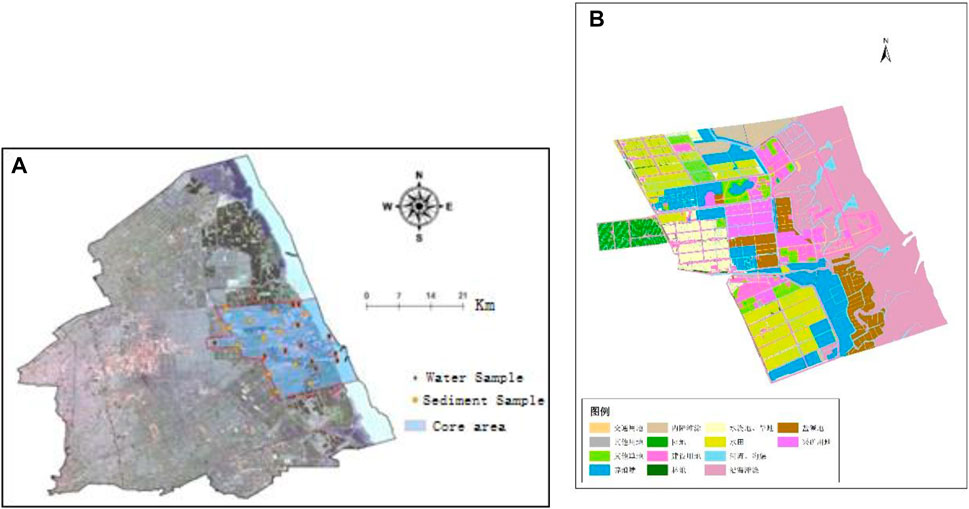
FIGURE 3. Location of the evaluation area (A) and land use type (B).
The remote sensing data employed in this study are the environmental satellite CCD remote sensing data (HJ1a-CCD2) that includes the following four bands: 0.43 ∼ 0.52, 0.52 ∼ 0.60, 0.63 ∼ 0.69, and 0.76 ∼ 0.90 μm. Remote sensing data are used to extract the spatial changes of coastal mudflats and mudflat farmlands and quantify them as evaluation indexes, with a spatial resolution of 30 m. In addition, Landsat ETM + remote sensing data were used to calculate NDVI, GVI, WI, and other evaluation indexes, and the spatial resolution was again 30 m. Furthermore, the measured data of heavy metals from the internal water and surface sediments sampled in the study area in 2014 were used to illustrate the pollution situation of heavy metals and quantify it as an evaluation index. The social and economic data of Dafeng in 2014 were used to reflect the degree of economic activities and the number of population within the research area, which were quantified as an evaluation index. Finally, the soil type distribution data were used to construct the soil type evaluation index.
3.2 Data Integration and Push
The multisource geographic data used in this case include vector data of tidal flat of Dafeng in 2000, and remote sensing image classification and interpretation data of land use, landscape pattern, population, and area of Dafeng in 1995, 2000, and 2005. The main analysis models used in this paper include the following: 1) the evolution of Dafeng tidal flat through the classification and interpretation of remote sensing data, and the changes of tidal flat structure over the years were obtained; 2) analysis of land use ratio per capita in Dafeng; and 3) landscape pattern analysis and the landscape index, using the classified landscape grid data and statistics of each unit value .
The model requirement template is shown clearly in Figure 4. The operation templates for different requirements are selected to construct the operation flow in line with the model data requirements by comparing the multisource data in the database (Figure 4). Subsequently, the vector data of tidal flat, remote sensing data, and attribute data were extracted from the original database by using the model demand template matching and processed by the model data operation flow (Figure 5).
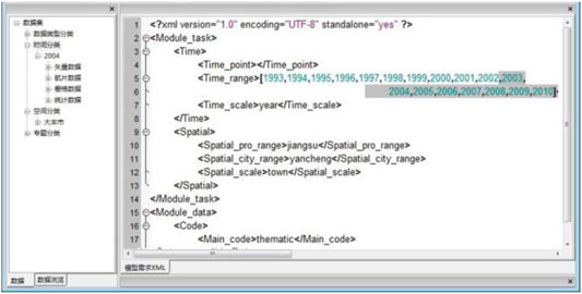
FIGURE 4. Template of models and data manipulating flows.
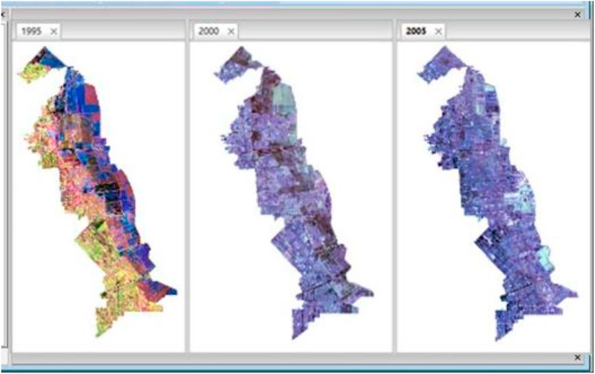
FIGURE 5. Results of the automatic push.
3.3 Safety Evaluation
Based on the remote sensing images and field observation data of the Dafeng region in 2014, we constructed an evaluation index system for coastal ecological security assessment for the purpose of fine-scale ecological security assessment. The objective layer of the evaluation system was the impact degree of ecological security status, and the criterion layer includes three aspects: population and economic pressure, ecological environment, and human–environment interaction. The indicator layer contains 10 types of indicators with a total of 16 specific quantitative indicators (Table 1). Specifically, the population, economy, tidal flat change, highway, industrial park, and ecosystem are macroscopic indexes, while the soil type, heavy metals in surface sediments, and heavy metals are microscopic indexes. Based on the criteria of population and economic pressure, ecological environment status, and human–environment interaction, the analytic hierarchy process (AHP) was used to assign the subjective weight of each quantitative index (of which, heavy metals in water body and heavy metals in surface sediments were treated as different categories, and the overall weight was determined before the internal equalization was carried out) (Figure 6), and the finally determined AHP weights of each index are presented in Table 2. Based on the ecological evaluation model to calculate comprehensive weight of each indicator, it was found that the larger the final index number, the worse the ecological security status of the evaluation unit.
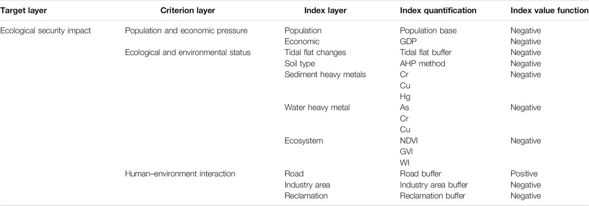
TABLE 1. Index system of comprehensive assessment of ecological security.
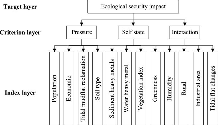
FIGURE 6. AHP weight structure hierarchy.
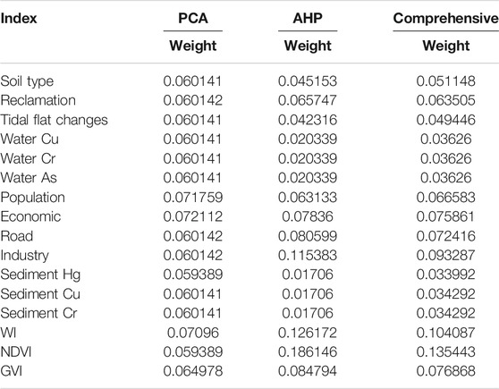
TABLE 2. Result of the weight index.
The comprehensive evaluation value of the ecological security degree of the evaluation unit (i.e., the pixel of remote sensing image) can be obtained by multiplying each quantitative index by the corresponding comprehensive weight after standardization. Considering that the difference between the evaluation value and the adjacent evaluation value is small, this article classifies the comprehensive evaluation value. We classified the evaluation value by a quantile based on R, set the quantile to 20, and assigned values from 1 to 20 to each category in order from the smallest to the largest, that is, the evaluation results were divided into 20 categories. The larger the assigned number, the worse the ecological security status of the evaluation unit (Figure 7).
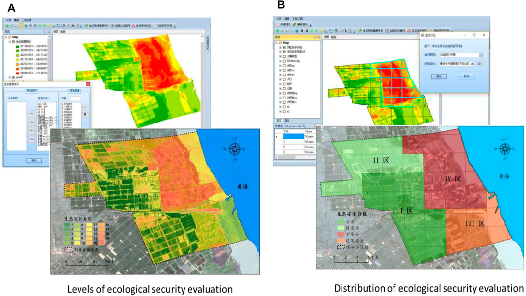
FIGURE 7. Publication of ecological security evaluation illustrated as levels (A), and levels can be transformed into zones (B).
3.4 Optimization of the Ecological Development Pattern
First, according to the ecological type and ecological value per unit area of the demonstration area, the Costanza model was selected to evaluate the ecosystem service value. Second, the patch density (PD), average patch area (AREA_MN), average shape index (SHAPE_MN), average proximity index (PROX_MN), connectivity degree (CONNECT), and so on were selected to dig deeply the relationship among various landscape types, and the spatial distribution of ecological function value of the demonstration area was consequently obtained. Furthermore, natural landscape types such as water and woodland with high service value per unit area and patches with an area greater than 40 hm2 were selected as the ecological source areas. Ecological source and cost (ecological resistance, determined by the value proportion of ecosystem service functions) were determined to obtain the cumulative cost distance surface of landscape ecological functions. Finally, based on the above results, the adjacent areas of mining, construction, and traffic lands with high ecological resistance were allocated with grassland, garden land, woodland, and other landscape types. According to the characteristics of the soil around the aquaculture ponds, low cost and high efficiency salt-tolerant plants and protective woodland were allocated in the adjacent coastal tidal mudflat to prevent pollutants from discharging into the coastal tidal mudflat. In order to optimize the allocation of ecological resources in the whole study area, woodland and grassland should be allocated around the farmland, and salt-tolerant cash crops such as sea-buckthorn, Chinese wolfberry and jujube should be selected for ecological desalination (Figure 8).
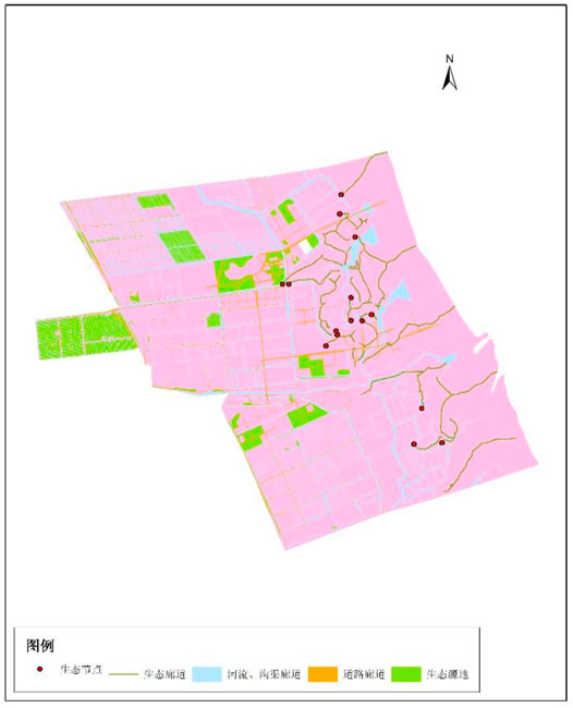
FIGURE 8. Results of pattern optimization.
3.5 Comprehensive Monitoring and Prescient Warning
The comprehensive monitoring detection platform is composed of three subsystems: monitoring, dynamic early warning, and emergency decision-making systems. It has the functions of dynamic update, supervision and management, retrieval and query, statistical analysis, online publication, and system maintenance of the supervision data of coastal tidal flat development and construction projects (Figure 9). Based on the idea of “one map” for coastal areas, a comprehensive supervision business flow coordinated by multiple departments was constructed, and a data model of ecological management and protection business flow serving coastal tidal mudflat was constructed using unified modeling language (UML). We integrated techniques to identify the relationship between changes in geomorphological, hydrological, and soil factors and the evolution of natural and artificial vegetation. According to different types of tidal flats wetland landscape reconstruction, land management, biodiversity maintenance and plant community building technology, as well as community stability and long-term management, the platform support series of functions: data acquisition and integration, dynamic update, query, statistical analysis, and publication, etc.
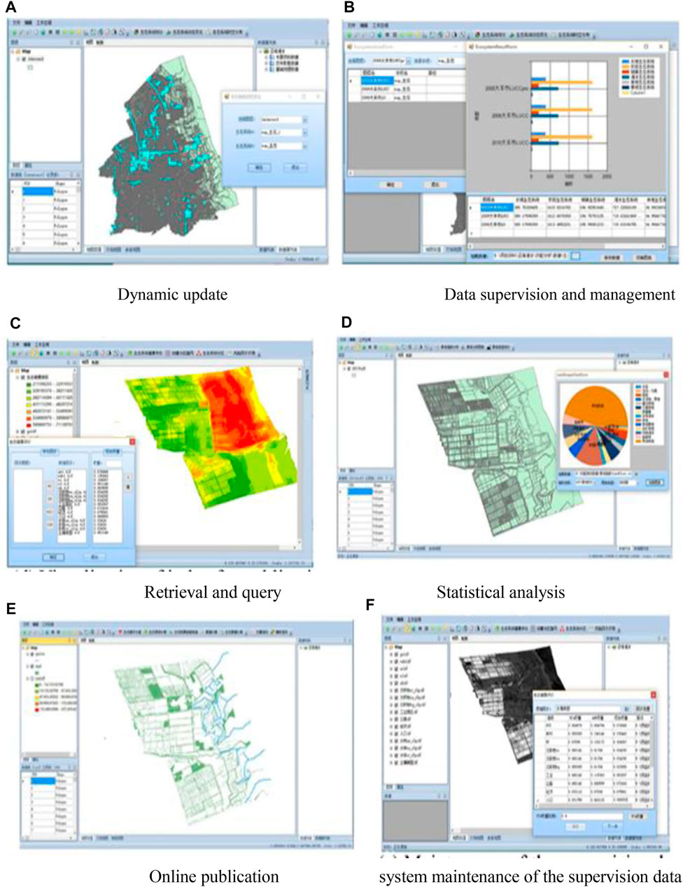
FIGURE 9. Demonstration of dynamical monitoring detection platform. (A) Dynamic update, (B) data supervision and management, (C) retrieval and query, (D) statistical analysis, (E) online publication, and (F) system maintenance of the supervision data.
4 Discussion
Due to the adoption of the adaptive integration technology of multisource data and based on the unified metadata standard, the comprehensive monitoring detection platform has already transformed, matched, and fused the multisource, multi-scale, and heterogeneous data in the data I/O and integration stage, which greatly shortened the data processing cycle. Through the adaptive data integration, the process of compatibility between old and new data was greatly shortened, so as to ensure that the updated data play a role more quickly and in real time. Meanwhile, the form of terminal data presented to users through data push technology has been combined with the timeliness of new data. Moreover, data push technology can not only be implemented according to the needs of the analysis model but also can be flexibly mastered according to the specific needs of the business so as to ensure the timeliness of the actual use of data at the client end. Application of the platform can help government departments to supervise and control the coastal ecosystem and analyze changes comprehensively.
Supported by data integration and push technology, the calculation and result presentation of the analysis model for monitoring, evaluation, optimized configuration, and early warning were all based on real-time updated data, and the presented analysis results are constantly changing over time. The comprehensive monitoring detection platform realized the integration of dynamic data update and supervision business process. The use of multiple sources of data in the process of supervision, coordination of various interests, ecological, environmental, land, social, and economic aspects was achieved.
On the basis of supporting data, we realize data collection and management and finally achieve the purpose of coordination and intelligent monitoring detection. The whole operation process from the bottom to the top is inter-associative. At the same time, due to the diversity of data and the multifaceted nature of the evaluation process, there are still some uncertainties in the analysis results in the process of mechanism analysis and comprehensive evaluation, such as the selection of some thresholds.
5 Conclusion
Integrated coastal zone management has always been one of the most important national development plans, but there are still issues that neglect the internal systematic research in various fields and neglect the multidisciplinary comprehensive research at the national macro level. The system structure and key technologies still need to be further improved and breakthrough. The ecological development and management of coastal tidal mudflat should be systematic and can be comprehensively improved from the perspectives of multidisciplinary comprehensive application, comprehensive data integration, model integration and sharing, and multifactor coupling analysis so as to establish relevant monitoring and supervision mechanisms and realize the overall improvement of the coastal zone management level. The construction of a comprehensive monitoring and detection platform for the ecological development of coastal tidal mudflat can provide support for the study of the development process of coastal tidal mudflat and supervision of human activities.
This article discusses the remote sensing image-based framework, functions, implementation ideas, and methods of the dynamic monitoring and analysis system, which can provide reference for the further development in the dynamic management of the overall coordination and comprehensive regulation of the coastal zone. The future highlights are as follows: 1) carrying out the research on the multidimensional unified data model and data assimilation based on six elements of location, attribute, semantics, geometry, time, and constraint, and solve the integrated dynamic management of multisource, multi-scale, multi-domain, and multi-resolution data; 2) model sharing and the integration mechanism oriented to resources, pattern structure, and process events support the construction of model coupling analysis platform integrating multidisciplines and multi-fields; and 3) study the warning and control mechanism of different levels for the public and government affairs, realizing the scientific guidance of social and government behaviors, and the coordination of interest conflicts (Brommer and Bochev-van der Burgh, 2009; Zhao et al., 2009; Li et al., 2011; Liang et al., 2011; Harvey et al., 2012).
Data Availability Statement
The raw data supporting the conclusions of this article will be made available by the authors, without undue reservation.
Author Contributions
SX and LY designed the ideas and methods. ZW, HL, and HG classified the data and drew the graphs. SX, LY, and ZY wrote the article with considerable input from ZW, HL, and HG. ZY revised and checked the language of the article.
Funding
This study is funded by the National Natural Science Foundation of China (No. 41971404). This work was also supported by the National Natural Science Foundation of China (No. 41801223) and the National Key Research and Development Foundation of China (No. 2017YFE0100700).
Conflict of Interest
The authors declare that the research was conducted in the absence of any commercial or financial relationships that could be construed as a potential conflict of interest.
Publisher’s Note
All claims expressed in this article are solely those of the authors and do not necessarily represent those of their affiliated organizations, or those of the publisher, the editors, and the reviewers. Any product that may be evaluated in this article, or claim that may be made by its manufacturer, is not guaranteed or endorsed by the publisher.
References
Brommer, M. B., and Bochev-van der Burgh, L. M. (2009). Sustainable Coastal Zone Management: a Concept for Forecasting Long-Term and Large-Scale Coastal Evolution. J. Coastal Res. 251 (1), 181–188. doi:10.2112/07-0909.1
Chen, J., Guan, W., and Sun, Y. (2009). Research on Dynamic Monitoring System for Land Use with 3S Technology. Geomatics World 7 (4), 60–65. (in Chinese with English abstract). doi:10.3969/j.issn.1672-1586.2009.04.012
Christensen, S. M., Tarp, P., and Hjortsø, C. N. (2008). Mangrove forest Management Planning in Coastal Buffer and Conservation Zones, Vietnam: a Multimethodological Approach Incorporating Multiple Stakeholders. Ocean Coastal Manage. 51 (10), 712–726. doi:10.1016/j.ocecoaman.2008.06.014
Dauvin, J. C. (2008). The Main Characteristics, Problems, and Prospects for Western European Coastal Seas. Mar. Pollut. Bull. 57 (1-5), 22–40. doi:10.1016/j.marpolbul.2007.10.016
Harvey, N., Clarke, B., and Nursey-bray, M. (2012). Australian Coastal Management and Climate Change. Geographical Res. 50 (4), 356–367. doi:10.1111/j.1745-5871.2011.00734.x
Henocque, Y. (2003). Development of Process Indicators for Coastal Zone Management Assessment in France. Ocean Coastal Manage. 46 (3-4), 363–379. doi:10.1016/s0964-5691(03)00013-9
Hou, Y., Chen, X., and Li, Y. (2005). Application of 3s Technologies in Integrated Coastal Zone Management. Hydrographic Surv. Charting 25 (3), 24–27. (in Chinese with English abstract). doi:10.3969/j.issn.1671-3044.2005.03.007
Hua, Z., Geng, Y., and Gu, L. (2012). Research Progress on Environmental Impact and Ecological Effect of Tidal Flat Reclamation. J. Econ. Water Resour. 30 (3), 66–69. (in Chinese). doi:10.3969/j.issn.1003-9511.2012.03.017
Lee, P. P. V. (1999). Providing Public Access to the Shore: The Role of Coastal Zone Management Programs. Coastal Manage. 27 (2-3), 219–237. doi:10.1080/089207599263848
Li, S., Huang, J., Shao, X., and Zhang, Y. (2011). Regional Ecological Compensation and Land Ecological Security. China Land Sci. 25 (5), 39–41. (in Chinese with English abstract). doi:10.3969/j.issn.1001-8158.2011.05.008
Liang, J., Song, P., Cui, T., Ren, G., and Zhao, W. (2011). Design and Implementation of HY-1 B CZI Coastal Zone Dynamic Monitoring System. Mar. Sci. Bull. 30 (1), 94–99. (in Chinese with English abstract). doi:10.3969/j.issn.1001-6392.2011.01.015
Liu, P., Zhang, H., and Eom, K. B. (2017). Active Deep Learning for Classification of Hyperspectral Images. IEEE J. Sel. Top. Appl. Earth Observations Remote Sensing 10 (2), 712–724. doi:10.1109/jstars.2016.2598859
Long, X.-h., Liu, L.-p., Shao, T.-y., Shao, H.-b., and Liu, Z.-p. (2016). Developing and Sustainably Utilize the Coastal Mudflat Areas in China. Sci. total Environ. 569-570, 1077–1086. doi:10.1016/j.scitotenv.2016.06.170
Paoli, C., Vassallo, P., and Fabiano, M. (2008). An Emergy Approach for the Assessment of Sustainability of Small Marinas. Ecol. Eng. 33 (2), 167–178. doi:10.1016/j.ecoleng.2008.02.009
Pickaver, A. H., Gilbert, C., and Breton, F. (2004). An Indicator Set to Measure the Progress in the Implementation of Integrated Coastal Zone Management in Europe. Ocean Coastal Manage. 47 (9-10), 449–462. doi:10.1016/j.ocecoaman.2004.06.001
Turner, R. K. (2000). Integrating Natural and Socio-Economic Science in Coastal Management. J. Mar. Syst. 25 (3-4), 447–460. doi:10.1016/s0924-7963(00)00033-6
Wang, G. (2013). Conditions and Innovation of Environmental Management on Tidal Flat in Coastal China. China Land Sci. 27 (4), 46–52. (in Chinese with English abstract). doi:10.3969/j.issn.1001-8158.2013.04.008
Wang, J., and Zou, X. (2009). Study on Environment Early Warning System of Coastal Zone in Yancheng. Adm. Tech. Environ. Monit. 21 (3), 19–23. (in Chinese with English abstract). doi:10.3969/j.issn.1006-2009.2009.03.006
Wang, Y., and Li, R. (2006). Landscape Ecological Planning in Southeast Coastal Zone in Hainan Island. Areal Res. Dev. 25 (5), 103–107. (in Chinese with English abstract). doi:10.3969/j.issn.1003-2363.2006.05.023
Xu, S., Du, R., and Wang, X. (2010).Research of post-approval Supervision System Based on GIS, Proceeding of the 2010 18th International Conference on Geoinformatics, June 2010, Beijing, China. IEEE, 1–5. doi:10.1109/geoinformatics.2010.5568079
Zhang, L. (1999). Comprehensive Management System and Operation Mechanism of Regional Coastal Zone — Taking Yuhuan County as an Example. Mar. Sci. Bull. 18 (3), 68–76. (in Chinese with English abstract).
Zhang, A. (2010). Design and Research of Land Resources" A Map" Data Management and Service Platform. Mod. Surv. Mapp. 33 (4), 41–42. (in Chinese with English abstract). doi:10.3969/j.issn.1672-4097.2010.04.014
Zhang, L., Liu, P., Zhao, L., Wang, G., Zhang, W., and Liu, J. (2021). Air Quality Predictions with a Semi-supervised Bidirectional LSTM Neural Network. Atmos. Pollut. Res. 12 (1), 328–339. doi:10.1016/j.apr.2020.09.003
Zhao, Z., Hua, Y., Wu, C., and Zhao, J. (2009). Dynamic Monitoring Techniques for the Implementation of Township Land Use Plan: A Case Study of Tangxi Town, Yuhang District, Hangzhou. China Land Sci. 23 (7), 43–48. (in Chinese with English abstract).
Keywords: remote sensing image, ecological development, monitoring detection platform, coastal tidal mudflat, data analysis
Citation: Xiao S, Yi L, Wang Z, Liu H, Gao H and Yu Z (2022) Remote Sensing Image-Based Comprehensive Monitoring Detection Platform for Coastal Tidal Mudflat Ecological Development. Front. Environ. Sci. 10:799027. doi: 10.3389/fenvs.2022.799027
Received: 21 October 2021; Accepted: 19 January 2022;
Published: 25 February 2022.
Edited by:
Peng Liu, Institute of Remote Sensing and Digital Earth (CAS), ChinaReviewed by:
Qinjun Qiu, China University of Geosciences Wuhan, ChinaFei Li, National Marine Environmental Monitoring Center, China
Copyright © 2022 Xiao, Yi, Wang, Liu, Gao and Yu. This is an open-access article distributed under the terms of the Creative Commons Attribution License (CC BY). The use, distribution or reproduction in other forums is permitted, provided the original author(s) and the copyright owner(s) are credited and that the original publication in this journal is cited, in accordance with accepted academic practice. No use, distribution or reproduction is permitted which does not comply with these terms.
*Correspondence: Zhaoyuan Yu, eXV6aGFveXVhbkBuam51LmVkdS5jbg==